United States Department of the Interior
|
|
|
- Cameron Day
- 5 years ago
- Views:
Transcription

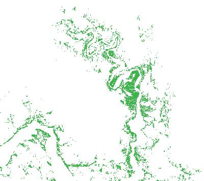
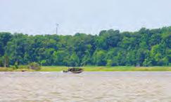
1 United States Department of the Interior NATIONAL PARK SERVICE Chesapeake Bay Office Chesapeake Bay ateways and Watertrails Network Captain John Smith Chesapeake National Historic Trail Star-Spangled Banner National Historic Trail 410 Severn Avenue, Suite 314 Annapolis, MD September 18, 2014 Mr. Randy Steffey U.S. Army Corps of Engineers Norfolk District 803 Front Street Norfolk, Virginia Re: Section Dominion Virginia Power s Surry - Skiffes Creek - Whealton Project Dear Mr. Steffey: Thank you for your recent regarding additional information on the Captain John Smith Chesapeake National Historic Trail. With this letter and attachments we are providing information that should assist you in assessing affects of Dominion Virginia Power s Surry - Skiffes Creek - Whealton Project on the trail. We provided a substantial portion of this information to you in prior correspondence, but are supplementing it here with additional points and graphic materials. 1. The Captain John Smith Chesapeake National Historic Trail (Captain John Smith Trail) commemorates Smith s voyages of exploration of the Chesapeake in , shares knowledge of the American Indian societies and cultures he interacted with during these journeys, and interprets the past and present natural history of the Chesapeake Bay. Congress designated the trail in 2006 through an amendment to Section 5(a) of the National Trails System Act (16 U.S.C. 1244(a)); it is the first nationally designated water trail under the Act. The trail route is found throughout the portions of the tidal Chesapeake explored by Smith, including the James and Chickahominy rivers; the trail was further extended by the Secretary of the Interior in May (See attachment A (John Smith Voyage Routes) and attachment B (Route of Captain John Smith Trail)) 2. The National Trails Systems Act identifies several elements of a national historic or scenic trail, which combine to determine the feasibility and desirability of designation of such trails. These elements include characteristics of nationally significant, well-preserved properties that can contribute or connect to the trail, which should be utilized for scenic, historic, natural, cultural or developmental purposes. Prior to establishment of the Captain John Smith Trail by Congress in December 2006, the trail route was determined by the National Park System Advisory Board in March 2006 to be nationally significant. ( While the trail route is not formally listed on the National Register of Historic Places (NRHP), it is treated by the National Park Service and the Virginia State Historic Preservation Officer as eligible for listing on the NRHP and as nationally significant. The trail clearly meets National Register criteria A, B and D. It is associated with events that have made a significant contribution to the
2 broad patterns of our history (criterion A); Smith s voyages and explorations of the Chesapeake Bay are among the most well known aspects of early colonial history that led to the formation of this nation. The trail is associated with the lives of significant persons in or past (criterion B); in addition to Smith himself, the trail is also associated with Powhatan and Pocahontas, two iconic figures in American history. The trail has yielded, and may be likely to yield, information important in history or prehistory (criterion D); recent and ongoing research along the trail on American Indian cultures, communities and indigenous cultural landscapes has and continues to yield significant new findings that inform knowledge of our collective history. 3. You asked whether the Captain John Smith Trail was purely commemorative in function. The answer is no. Seven years of trail planning, development and conservation activities make this clear. The National Park Service completed a Comprehensive Management Plan (CMP; for the trail in The CMP states: The promise of the Captain John Smith Chesapeake National Historic Trail, then, is to help the millions of people in the region and elsewhere experience, envision, come to understand, and care to protect what the explorers and the inhabitants of the region saw 400 years ago: by expanding access to the Bay and rivers; by protecting special places reminiscent or evocative of those times; by educating the public of the importance and exceptional nature of the region, its people, and its resources; by providing recreational experiences throughout the region; by creating partnerships amongst the many citizens, groups and jurisdictions to realize the vision; by instilling awe and reverence for the special places in the Chesapeake region. Visitor experiences on the trail will include journeys on land walking, bicycling, motoring and sojourns on water paddling, sailing and cruising, in craft large and small. The trail will provide national park quality experiences through NPS partnerships with state and local governments, and non profit and for profit organizations. (emphasis added) 4. Trail management focuses on providing visitors with experiences of trail-related resources and on conserving those resources. The CMP identifies seven principle types of trail-related resources: (1) John Smith voyage stops: Locations where Smith and his crew stopped during the voyages. (2) Evocative landscapes: Visible shoreline generally evocative of the seventeenth century encompassing stretches where the shoreline is relatively free from intrusion by modern development and offers visitors an opportunity to vicariously share the experience of Smith and his crew. Such shorelines are primarily composed of wetland and forest vegetation. (3) Indigenous cultural landscapes: Landscapes generally encompassing cultural and natural resources that would have likely been associated with, and supported, the historic lifestyle and settlement patterns of American Indians and that exhibited their cultural or esthetic values at the time of early European contact. (4) Historic American Indian town sites: Historic American Indian town sites including, but not limited to, those mapped in John Smith s Chesapeake Voyages (Rountree et al. 2007), John Smith in the Chesapeake (Haile 2008), and others. (5) Significant seventeenth-century American Indian archeological sites: Sites listed on the National Register of Historic Places, or determined to be eligible for listing, which offer an opportunity to tell important stories of the native peoples who lived in the Chesapeake when John Smith arrived.
3 (6) Landscape features and cultural sites of significance to modern American Indian tribes: Sites which consultation or scholarly research has documented as culturally significant to modern Chesapeake Bay tribes, having an historical connection to a 17 th century tribe and in proximity to the Smith voyage route. (7) Cross sites: Twenty-five general locations in proximity to the trail where Smith s maps indicate that he or others placed a brass cross, marking the limits of their exploration. These sites are generally known on the basis of interpretation of Smith s maps, his journal writings, and scholarly research. (8) Public access sites: Places where the public can view Smith s voyage routes from the land or gain physical access to the water along voyage routes for boating, fishing, swimming, or other recreational use. Several of these resources are addressed in more detail below. Copies of two maps published in the CMP to depict some of these resources in the vicinity of the James segment of the trail are attached (see attachments C and D). 5. The CMP identifies initial high potential route segments and high potential historic sites as required by the National Trails System Act (NTSA). All segments of the trail have the potential to provide important opportunities for visitors to experience the world encountered by John Smith and his crew as they explored the Chesapeake Bay. Those trail segments or sites along the trail that meet criteria for designation as high-potential historic sites and high-potential route segments offer exceptional opportunities for visitors to vicariously share the experience of John Smith and his crew. Because these sites and segments are exceptional, trail management actions would place priority on protecting their associated resources and values that are fundamental to the trail and on enhancing the opportunities which visitors have to experience those resources and values. The tidal James from its mouth to Richmond is identified as a high potential route segment. High potential route segments as defined in the NTSA means those segments of a trail which would afford high quality recreation experience in a portion of the route having greater than average scenic values or affording an opportunity to vicariously share the experience of the original users of a historic route. (see attachments C, D and E for maps depicting high potential route segments) 6. The trail corridor, as identified in A Conservation Strategy for the Captain John Smith Chesapeake National Historic Trail (NPS 2013; is the composite of evocative landscapes, indigenous cultural landscapes and other trail-related resources along the trail route. 7. The National Park Service, working with many local and regional partners and through a public process, completed A Plan for the James Segment ( of the trail in 2011, as called for in the CMP. The segment plan identifies focus areas for enhancing and expanding visitor experiences in the time period. Two focus areas are identified in the vicinity of the proposed James power line crossing: the Jamestown/Powhatan Creek Focus Area, and the Chippokes Plantation State Park and Hog Island Wildlife Management Area Focus Area. (see attachments F,, H, I). The proposed Surry-Skiffes Creek crossing originates in and cuts through the Chippokes Plantation State Park and Hog Island Wildlife Management Area Focus Area. (This crossing is also within view of the Jamestown/Powhatan Creek Focus Area.) The James segment plan
4 identifies a series of visitor experiences in the Chippokes/Hog Island focus area, including boating and wildlife viewing in an evocative landscape. The plan cites visitors launching boats, canoes and kayaks from a boat ramp below Lawnes Creek and exploring Hog Island WMA from the James. The proposed Surry-Skiffes Creek line would cut directly through this route. The segment plan also identifies the Jamestown and Powhatan Creek focus area (just up river from Hog Island) as a destination for sail or power boaters following the trail on longer cruising experiences. The vicinity around Hog Island, where the Surry-Skiffes Creek line is proposed is the functional entrance to Jamestown Island, one of the most significant sites along the trail. 8. Visitor experiences along a water trail are defined by the view of land and waterscapes from a river, creek or the Bay. As noted in 4(2) above, the trail CMP defines evocative landscapes as a core trail resource upon which visitor experiences depend. Evocative landscapes are places possessing a feeling that expresses the aesthetic or historic sense of a particular period of time. This feeling results from the presence of physical features that, taken together, convey a landscape s historic character. The CMP further defines this as visible shoreline generally evocative of the 17 th century - primarily composed of forests and wetlands. The presence of evocative landscapes is one component for identifying high potential route segments noted in 5 above. The National Park Service performed an initial identification of the trail s evocative landscape as viewed from the water when developing the CMP. Trail-wide maps were developed and published in the CMP. Since that time, the National Park Service has performed more detailed mapping of evocative landscapes along the trail route in several locations, including in the vicinity of the proposed crossing route. This uses IS data to map shoreline composed of forest and wetlands visible from the trail. This analysis indicates that the vast majority of the shoreline (greater than 85%) along this portion of the trail route is composed of evocative landscapes. In July 2014 the National Park Service traveled this section of the James on a boat to field check the IS mapping. National Park Service staff documented on-water views of shorelines along the trail route in the vicinity of the project area and confirmed the magnitude of evocative landscapes. (see attachment J for 2013 Evocative Landscapes Map with 2014 photo documentation.) 9. The proposed Surry-Skiffes crossing is in the midst of an approximately fifty-one mile stretch of the James with no overhead crossings; this constitutes a substantial viewshed resource of the John Smith Trail. In contrast to much land-based development which often has the potential for being screened from the view of visitors traveling by water, structures crossing a river, including towers in the water and powerlines, are effectively un-screenable. Moreover, along a water trail these crossings do not simply intrude on the view from a distance; overhead crossings are experienced continuously from a distance to close up to overhead. They constitute major impacts on the visitor experience. Neither Dominion nor the USACE have provided analysis or modeling of the visual impacts of the Surry-Skiffes crossing from the national historic trail visitor perspective. Modeling of the impacts as viewed from boaters traveling to and exploring Hog Island WMA, and as viewed from cruising boaters traveling along the trail up the James to Jamestown is necessary. This will be essential information to accurately assess the impacts this potential project could have on trail resources. 10. Resources and values important to American Indians are central to the Captain John Smith Trail. The trail and its resources provides an opportunity for helping visitors and citizens understand the long history of indigenous stewardship of the Chesapeake region prior to European contact, the early interactions with English colonists, and the values of tribes and descendent communities today. This is at the core of instilling awe and reverence for the special places in the Chesapeake region as noted in item 3 above. The CMP lists several types of trail-related resources associated
5 with American Indians, as noted in item 4 above. Some of these have been identified and mapped, but many have not. To support interpretation and conservation of American Indian resources along the trail, the National Park Service, in partnership with tribes and other organizations, has initiated steps for documenting Indigenous Cultural Landscapes (ICLs), noted above in 4(3) above. A methodology has been developed (see Report-of-ICL-Methodology-and-Recommendations-Final.pdf) and mapping is underway in several locations along the trail. Such documentation and mapping has not yet occurred along the James in the general vicinity of the proposed Surry-Skiffes Creek crossing. However, it is reasonable to assume there is a likelihood that ICLs exist within this area, given the patterns of known indigenous use during the contact era, existing archeologic sites, historic agricultural soil information and the presence of natural resources important to indigenous peoples; (note the existing presence of sturgeon today). Further consultation with American Indian tribes should be conducted to outline and identify these ICLs and other resources important to American Indians. I hope the information above is helpful in communicating some of the resources, historic properties, and concerns relative to conserving visitor experiences and the landscape along the Captain John Smith Chesapeake National Historic Trail. I and my staff would be happy to talk with you further and provide additional information as this matter proceeds. Jonathan Doherty, Assistant Superintendent, will participate in the September 25 consulting parties meeting. Thank you very much for your attention. Sincerely, Charles Hunt Superintendent c: Julie Langan, Virginia Department of Historic Resources Roger Kirchen, Virginia Department of Historic Resources John Eddins, Advisory Council on Historic Preservation Attachments: A through J
6 A N o r t h eas t R iv er Susquehanna R iv er Elk R iv er MARYL A N D Sassafras R iv er B al ti mo re Dover Patapsc o A nnap o l is Was hi ng to n A l e x a n d ri a D E L AWA R E Patuxent Cambridge N an t ic o ke R iv er F re de r i c ks b u rg Po to mac R iver Pocomoke R iv er Rappahannock R iver V IRINIA Chesapeake Bay Mattaponi Atlantic Ocean Ri c hm o n d Pamunkey Chickahominy Piankat an k York Cape Ch arles Figure 1.2: Voyage Routes James Voyage Stop John Smith Voyages Composing the Trail John Smith Voyage 1 John Smith Voyage 2 John Smith Other Voyage Nansemond Norfolk Eliz ab et h R iv er National Park Service U.S. Department of the Interior Miles
7 Captain John Smith Chesapeake National Historic Trail National Park Service Chesapeake Bay Office Legend Captain John Smith Chesapeake National Historic Trail N e w Y o r k Cooperstown West Branch Susquehanna P e n n s y l v a n i a Susquehanna Harrisburg N e w J e r s e y M a r y l a n d Baltimore W e s t V i r g i n i a Washington, DC Annapolis Chester D e l a w a r e Potomac V i r g i n i a Nanticoke Rappahannock James York Richmond Miles Jamestown A t l a n t i c O c e a n 4


 Smith s maps indicate that he or his crew set a")

 Rappahannock Ri ve r CINQUOTEK Cross Sites")


8 Figure 2.7f: High Potential Historic Sites, High MORAUHTACUND Potential Route Segments, and 1,2 Other Trail Related Resources C Lower Bay (5 of 5) High Potential Historic Sites Significant Voyage Stops within a Setting that is Highly Evocative of the 17th Century Significant 17th Century American Indian Archeological Sites (including sites listed on or determined eligible for the National Register of Historic Places) Kilm arnoc k Indigenous Cultural Landscapes or Sites that are Culturally Significant to Modern Chesapeake Bay Tribes (to be determined) 17 Sites along the Voyage Routes that are Highly Evocative of the 17th Century3 High Potential Route Segments Rappahannock OPISCOPANK James CUTTATAWOMEN I Other Trail-Related Resources Other Voyage Stops (including all other voyage stops that do not meet criteria for designation as a high potential historic site) Smith s maps indicate that he or his crew set a brass cross marking the upriver limit of their voyage route) Historic American Indian Town Sites Visible Shoreline enerally Evocative of the 17th Century High Pot en tial Rou t e Segmen t (see Figu re 1.4d for u pstream limit ) Rappahannock Ri ve r CINQUOTEK Cross Sites (general locations in close proximity to the trail where PAYANKATANK ACCOHANOCK Existing Public Access Sites Designated Water Trails (including water trails managed by a trail partner who provides water trail mapping and marking, and ideally some interpretive media/programming and trail facilities) 1 13 E xmore Chesapeake Bay Scenic Byways, Auto Routes, and Land Trails Protected Lands that are Open to the Public (including federal, state, local lands, and private lands, exclusive of military lands and wildlife refuges that are closed to the public) Protected Lands that are Closed to the Public (generally including private land protected by conservation easements) Chesapeake Bay ateways and Watertrails Network Partner WEROWOCOMOCO See Section 2.4 of the CMP text for criteria used for designation In the future, further research and/or changing resource conditions along the trail could support decisions by the NPS to add or delete one or more high potential historic sites. 2 Yor k As part of the CMP planning process, the NPS has applied high potential historic site criteria to eight segments of the trail. Further site-specific analyses of the remainder of the voyage routes are needed to identify additional high potential historic sites that meet designation criteria. 3 Mobjack Bay National Park Service U.S. Department of the Interior Hog Island Bay 12 Miles KISKIACK Willia msb u rg Cape Charl es Mockhorn Bay ACCOWMACK Magothy Bay Po q uoson James Rive r H am pton At l an t i c O c ean KECOUHTAN 60 S mit h fie l d NANDSAMUND Na nse mond Ri ve r Suffo lk Norf ol k 664 John Smith Voyage 1 John Smith Voyage 2 John Smith Other Voyage Map Stop High Poten t ial Rou te Segmen t (see Figu re 1.4d for u pst ream limit) WARRASKOYACK E l iza b e t h Ri v e r 64 Po rtsmouth Che sapeake Vi rgi ni a Beach CHESAPEACK


")


 Cross Sites")


9 CECOMOCOMOCO M AR MARYL RYL RY YLL A N Y ND D CUTTATAWOMEN II Rappahannock, York and James s area (4 of 5) High Potential Route Segment (see Figure 1.4e for downstream limit) Figure 2.7e: D High Potential Historic Sites, High Potential Route Segments, and 1,2 Lexington Park Other Trail Related Resources High Potential Historic Sites Significant Voyage Stops within a Setting that is Highly Evocative of the 17th Century P o to ma c Significant 17th Century American Indian Archeological Sites (including sites listed on or determined eligible for the National Register of Historic Places) NANDTAUHTACUND YOACOMOCO V IR R IN IA A PISSASECK Indigenous Cultural Landscapes or Sites that are Culturally Significant to Modern Chesapeake Bay Tribes (to be determined) ONAWMANIENT Sites along the Voyage Routes that are Highly Evocative of the 17th Century3 High Potential Route Segments Rappahannock James and Chickahominy Other Trail-Related Resources Other Voyage Stops (including all other voyage stops that do not meet criteria for designation as a high potential historic site) Cross Sites (general locations in close proximity to the trail where Smith s maps indicate that he or his crew set a brass cross marking the upriver limit of their voyage route) Historic American Indian Town Sites Visible Shoreline enerally Evocative of the 17th Century Warsaw Existing Public Access Sites CEKAKOWAN Designated Water Trails (including water trails managed by a trail partner who provides water trail mapping and marking, and ideally some interpretive media/programming and trail facilities) Tappah an n ock Scenic Byways, Auto Routes, and Land Trails TOPPOHANOCK Protected Lands that are Open to the Public (including federal, state, local lands, and private lands, exclusive of military lands and wildlife refuges that are closed to the public) Protected Lands that are Closed to the Public (generally including private land protected by conservation easements) Chesapeake Bay ateways and Watertrails Network Partner 1 See Section 2.4 of the CMP text for criteria used for designation In the future, further research and/or changing resource conditions along the trail could supportmorauhtacund decisions by the NPS to add or delete one or more high potential historic sites. 2 As part of the CMP planning process, the NPS has applied high potential historic site criteria to eight segments of the trail. Further site-specific analyses of the remainder of the voyage routes are needed to identify additional high potential historic sites that meet designation criteria. 3 Rappahannock National Park Service U.S. Department of the Interior 0 Mattaponi Ri v e r Miles OPISCOPANK Pam unkey Ri v er High Potential Route Segment (see Figure 1.4e for downstream limit) MENAPUCUNT KUPKIPCOCK Rich m o nd CINQUOTEK PAYANKATANK POWHATAN High Potential Route Segment ARROHATECK WEROWOCOMOCO Yo rk H o p e w e ll WEANOCK Chickahominy James Ri v er 5.21, 1607 PASPAHEH Wi l l i amsbu rg KISKIACK Peters b u rg QUIYOUHCOHANOCK Ja m e st o w n N ew port N ew s John Smith Voyage 1 John Smith Voyage 2 John Smith Other Voyage


10 Figure i 2. The Trail s High Poten al Routes and High Poten al Sites 4
11 Focus Area Locations The illustration below shows the five focus areas described in this section. Each contains solid resources and stories associated with Smith s explorations, American Indian cultures of the time, and significant, evocative 17 th century landscapes. Each focus area provides a series of different immersive visitor experience opportunities associated with the trail. Chickahominy and front Park James Oxbows Jamestown and Powhatan Creek Chippokes Plantation State Park and Hog Island Wildlife Management Area Pagan and Town of Smithfield 14
12 Focus Areas in Relation to the Trail s Major Journey Themes The map below depicts the five initial focus areas in relation to several major themes associated with John Smith's journeys on the James. These represent major themes only; a series of more detailed stories are associated with each focus area. Smith s explorations on the James and its major tributaries tributaries meeting with tribes, bartering and exchanging in hostilities Jamestown Island as location of first permanent English colony and home base for Smith's explorations and other activities and other activities to sustain the colony Smith s departure and return routes of his exploratory voyages of the Chesapeake yg 15
13 Indian Tribes Associated with Focus Areas Each of the focus areas has an association with one or more Indian Tribes. This graphic briefly summarizes several main associations. There are numerous more specific stories and resources associated with each. Arrohateck The Arrahateck Indians occupied this area during Smith s visits. Years later, Pocahontas was taken to Henricus after having been captured by the English. Features supporting these stories include: the recreated Arrahateck town at Henricus Historical Park and associated interpretive programs convey some aspects of life during the 17 th century; wildlife and fish throughout the area, especially at Presquile t il National Wildlife Refuge convey the importance of these resources to Virginia Indians. Chickahominy In the early 17 th century, the Chickahominy lived in many towns on both sides of the Chickahominy. All the food, shelter, medicine, and materials needed for tools and transportation were available from the river area s many resources, including its Paspahegh The area was the territory of the Paspahegh Indians at the time of English settlement. The Paspahegh had fertile agricultural soil. multiple towns along the James on both sides of towns the on sides of Quiyoughcohannock Smith and Jamestown colonists explored this area of the James and met with Chippokes, a leader of the Quiyoughcohannock Tribe, in the vicinity of the state park. Although Chippokes remained supportive of the English, others of the Quiyoughcohannock resisted the colony so close to their territory. l t t it Warraskoyack The Warraskoyeck Indians inhabited the area and Smith traveled up the Pagan to visit with and trade with the tribe. In his later writings, Smith claimed to have been warned by the leader of the by the leader of the Warraskoyack in late 1608 that the paramount chief Powhatan intended harm to him. the mouth of the Chickahominy. They were resistant of the English intrusion onto their land, and this discordance was the cause of much of the colony s early troubles. 17


 Turkey Island Creek Launch")


14 James Segment Focus Areas & Anchors Captain John Smith Chesapeake National Historic Trail National Park Service Chesapeake Bay Office Chapel Island Launch Legend Focus Area for Near-Term Trail Development Anchor Site CAJO Kiosks/Sign Panels Near-term and Completed Public Access Development Osborne Park CAJO kiosk James Oxbows Drewry s Bluff Water Access (YCC) Turkey Island Creek Launch Chickahominy Henricus -- Dutch ap Launch CAJO Kiosk Presquile NWR CAJO signage Lawrence Lewis Jr. Park Boat Launch & Beach Access (YCC) Chickahominy WMA Morris Creek Launch CAJO Kiosk CAJO Panel Jamestown & Powhatan Creek College Creek Launch (YCC) Jamestown Beach Park CAJO signage Eco-Discovery Park Launch (YCC) & Sign CAJO Kiosk Chippokes & Hog Island CAJO Kiosk Pagan & Smithfield Huntington Park CAJO kiosk Fort Monroe NM Route 10/258 Launch CAJO Kiosk Henricus Historical Park Morris Creek Jamestown Settlement Chippokes State Park Pagan Fort Monroe Mill Creek Access CAJO Kiosk Sleepy Hole Park Launch Nansemond Constance Wharf Launch Bennett s Creek Park CAJO kiosk


15 CARTERS ROVE APPROXIMATE CROSSIN LOCATION APPROXIMATE CROSSIN LOCATION JULY 2014
Captain John Smith Chesapeake National Historic Trail CMP
 National Park Service U.S. Department of the Interior Captain John Smith Chesapeake National Historic Trail CMP November, 2010 Briefing Overview Purpose Management Alternatives Management framework Next
National Wilderness Steering Committee
 National Wilderness Steering Committee Guidance White Paper Number 1 Issue: Cultural Resources and Wilderness Date: November 30, 2002 Introduction to the Issue Two of the purposes of the National Wilderness
MASTER PLAN EXECUTIVE SUMMARY
 Biscuit Run State Park Scottsville Road (State Route 20) Charlottesville, VA 22902 Biscuit Run State Park MASTER PLAN EXECUTIVE SUMMARY Department of Conservation and Recreation Division of Planning and
JOSLIN FIELD, MAGIC VALLEY REGIONAL AIRPORT DECEMBER 2012
 1. Introduction The Federal Aviation Administration (FAA) recommends that airport master plans be updated every 5 years or as necessary to keep them current. The Master Plan for Joslin Field, Magic Valley
Lower Susquehanna River Segment Implementation Plan
 National Park Service U.S. Department of the Interior A partnership for enhancing the National Trails along the Lower Susquehanna River Lower Susquehanna River Segment Implementation Plan 2018 Prepared
Blueways: Rivers, lakes, or streams with public access for recreation that includes fishing, nature observation, and opportunities for boating.
 Parks, Open Space and Trails PRINCE WILLIAM COUNTY 2008 COMPREHENSIVE PLAN TRAILS PLAN CONTENTS The components of the trails plan are: Intent Definitions Goals, Policies, and Action Strategies Trails Map
UNITED STATES DEPARTMENT OF THE INTERIOR BUREAU OF LAND MANAGEMENT MANUAL TRANSMITTAL SHEET
 Form 1221-2 (June 1969) UNITED STATES DEPARTMENT OF THE INTERIOR BUREAU OF LAND MANAGEMENT MANUAL TRANSMITTAL SHEET Release 8-83 Date Subject 8353 Trail Management Areas Secretarially Designated (Public)
April 10, Mark Stiles San Juan Public Lands Center Manager 15 Burnett Court Durango, CO Dear Mark,
 Mark Stiles San Juan Public Lands Center Manager 15 Burnett Court Durango, CO 81301 Dear Mark, We are pleased to offer the following comments on the draft San Juan Public Lands Center management plans
Rogue River Access and Management Plan Draft Alternatives
 Rogue River Access and Management Plan Draft Alternatives The Rogue River Access and Management Plan was initiated in December, 2011 and is being led by Jackson County Parks (JCP) and Oregon Department
Washington Township MASTER PLAN. Addendum: Washington Township Master Plan
 Washington Township MASTER PLAN Addendum: Washington Township Master Plan CHAPTER XI RECREATION CORE DISTRICT Introduction The Recreation Core District generally encompasses the areas north of 30 Mile
The Vision for the San Juan Islands Scenic Byway
 The Vision for the San Juan Islands Scenic Byway 2 Judd Cove, Orcas Island, Courtesy of Kurt Thorson (kurtthorson.com) and San Juan County Land Bank Vision for the San Juan Islands Scenic Byway The San
North Shore Lacamas Lake
 North Shore Lacamas Lake January 27, 2017 A Vision for Conservation and Recreation Acknowledgements Funding Funding for this planning effort was provided by the City of Camas and the Columbia Land rust
Continental Divide National Scenic Trail Legislative History and Planning Guidance
 Continental Divide National Scenic Trail Legislative History and Planning Guidance Legislation, Policy, and Direction Regarding National Scenic Trails The National Trails System Act, P.L. 90-543, was passed
Section 106 Update Memo #1 Attachment D. Traffic Diversion & APE Expansion Methodology & Maps
 Section 106 Update Memo #1 Attachment D Traffic Diversion & APE Expansion Methodology & Maps I-65/I-70 North Split Interchange Reconstruction Project (Des. Nos. 1592385 & 1600808) Traffic Diversion and
WEKIVA WILD AND SCENIC RIVER ACT OF 2000
 PUBLIC LAW 106 299 OCT. 13, 2000 WEKIVA WILD AND SCENIC RIVER ACT OF 2000 VerDate 11-MAY-2000 01:59 Oct 20, 2000 Jkt 069139 PO 00000 Frm 00001 Fmt 6579 Sfmt 6579 E:\PUBLAW\PUBL299.106 APPS27 PsN: PUBL299
CITY OF VAUGHAN EXTRACT FROM COUNCIL MEETING MINUTES OF OCTOBER 30, 2012
 CITY OF VAUGHAN EXTRACT FROM COUNCIL MEETING MINUTES OF OCTOBER 30, 2012 Item 36, Report No. 39, of the Committee of the Whole, which was adopted without amendment by the Council of the City of Vaughan
Appendix L Technical Memorandum Aesthetics
 Technical Memorandum Aesthetics 1.0 AESTHETICS This section provides a discussion of the aesthetic resources in the vicinity of ARTIC. Aesthetics pertain to the elements that make a certain view pleasing
NOTE: the Potomac Heritage Trail corridor is not included on any of our maps, as it was not finalized as of the printing of the draft.
 Lardner/Klein Landscape Architects, P.C. Memorandum: To: Beth Clark (Charles County), Cathy Hardy (Charles County), Teri Wilson (St. Mary s County) From: Jim Klein Date: May 30, 2008 [Updated July 23,
RE: Access Fund Comments on Yosemite National Park Wilderness Stewardship Plan, Preliminary Ideas and Concepts
 September 30, 2016 Superintendent Yosemite National Park Attn: Wilderness Stewardship Plan P.O. Box 577 Yosemite, CA 95389 RE: Access Fund Comments on Yosemite National Park Wilderness Stewardship Plan,
Rule Governing the Designation and Establishment of All-Terrain Vehicle Use Trails on State Land
 Rule Governing the Designation and Establishment of All-Terrain Vehicle Use Trails on State Land 1.0 Authority 1.1 This rule is promulgated pursuant to 23 V.S.A. 3506. Section 3506 (b)(4) states that an
RUSHMORE CONNECTOR TRAIL PROPOSAL
 PURPOSE AND NEED Background The U.S. Forest Service, Black Hills National Forest (Forest Service) has received a special use permit application from the State of South Dakota Department of Game, Fish and
A CASE FOR COMPLETING THE JORDAN RIVER PARKWAY: A
 A CASE FOR COMPLETING THE JORDAN RIVER PARKWAY: A safe crossing at 9000 South and 850 West Proposed 9000 South Underpass Parkway Timeline Parkway, Trail, and Tourism Facts Blueprint Jordan River 1971 1973
Segment 2: La Crescent to Miller s Corner
 goal of the USFWS refuges is to conserve, protect and enhance fish, wildlife and plants and their habitats for the continuing benefit of the American people. Refuge lands are used largely for fishing,
Rappahannock River Crossing Project; Ms. J. V. Langan; May 28, 2015 Page 2 of 6
 Page 2 of 6 VDOT engaged the consultant firm McCormick Taylor to conduct the historical research and Phase I and Phase II field investigations necessary to identify and assess the significance of archaeological
Citrus Heights Creek Corridor Trail Project. Trail Advisory Group Meeting #3 July 8, 2013
 Citrus Heights Creek Corridor Trail Project Trail Advisory Group Meeting #3 July 8, 2013 Agenda Introductions Recap: Community Workshop, Survey Findings, and TAG Field Trip Community Concern Discussion:
Classifications, Inventory and Level of Service
 Classifications, Inventory and Level of Service Section 3 Kenmore Park, Recreation and Open Space Plan 1 P a g e Classifications and Inventory Park Classifications Kenmore classifies its parks based upon
Environment and Natural Resources Trust Fund 2019 Request for Proposals (RFP)
") Environment and Natural Resources Trust Fund 2019 Request for Proposals (RFP) Project Title: Glacial Edge Trail and Downtown Pedestrian Bridge Category: G. Land Acquisition for Habitat and Recreation ENRTF
Environment and Natural Resources Trust Fund 2019 Request for Proposals (RFP) Project Title: Glacial Edge Trail and Downtown Pedestrian Bridge Category: G. Land Acquisition for Habitat and Recreation ENRTF
Wilderness Stewardship Plan Scoping Newsletter Winter 2013
 Olympic National Park National Park Service U.S. Department of the Interior Wilderness Stewardship Plan Scoping Newsletter Winter 2013 Dear Friends and Neighbors, The Olympic Wilderness was established
PROUDLY BRINGING YOU CANADA AT ITS BEST. Management Planning Program NEWSLETTER #1 OCTOBER, 2000
 PROUDLY BRINGING YOU CANADA AT ITS BEST VUNTUT NATIONAL PARK Management Planning Program NEWSLETTER #1 OCTOBER, 2000 INTRODUCTION This newsletter launches the development of the first management plan for
Mt. Hood National Forest
 United States Department of Agriculture Forest Service Mt. Hood National Forest Zigzag Ranger District 70220 E. Highway 26 Zigzag, OR 97049 503-622-3191 Fax: 503-622-5622 File Code: 1950-1 Date: June 29,
I. PREFACE II. THE PARTNERSHIP
 I. PREFACE This document is the "local" plan for the management of the Appalachian Trail in Maine from Maine Highway 26 in Grafton Notch to the summit of Katahdin. It is a part (the other being the Appalachian
Inholdings within Wilderness: Legal Foundations, Problems, and Solutions
 In the western United States, land inholdings in wilderness are largely a result of five legislative acts: the 1872 Mining Law (17 Stat. 91), the 1862 Homestead Act (12 Stat. 392), the 1864 and 1870 Land
Final Environmental Impact Statement for the Merced Wild and Scenic River. Comprehensive Management Plan, Yosemite National Park, Madera and Mariposa
 This document is scheduled to be published in the Federal Register on 02/26/2014 and available online at http://federalregister.gov/a/2014-04061, and on FDsys.gov DEPARTMENT OF THE INTERIOR 4312-FF NATIONAL
National Recreation Trail Application for Designation
 National Recreation Trail Application for Designation Introduction Thank you for your interest in the National Recreation Trail (NRT) program. Completed NRT application packages must be submitted by December
NATIONAL PARK SERVICE CERTIFICATION OF COMPLETED SEGMENTS OF THE NORTH COUNTRY NATIONAL SCENIC TRAIL
 NATIONAL PARK SERVICE CERTIFICATION OF COMPLETED SEGMENTS OF THE NORTH COUNTRY NATIONAL SCENIC TRAIL Completed trail segments that (1) follow the route identified in the 1982 National Park Service (NPS)
Potomac River Commuter Ferry Feasibility Study & RPE Results
 1.1 Introduction The Prince William County Department of Transportation conducted a route proving exercise (RPE) and feasibility study of a proposed commuter ferry service on the Potomac River between
Proposal to Redevelop Lower Kananaskis River-Barrier Lake. Bow Valley Provincial Park. Frequently Asked Questions
 Proposal to Redevelop Lower Kananaskis River-Barrier Lake Bow Valley Provincial Park Frequently Asked Questions What is being proposed? What are the details of the proposal? Where is the project area located?
DAKOTA CULTURE UPPER SIOUX COMMUNITY: AREA CHARACTER ANALYSIS ALIGNMENT STRATEGY
 UPPER SIOUX COMMUNITY: AREA CHARACTER ANALYSIS ALIGNMENT STRATEGY 51 AREA CHARACTER ANALYSIS: OPPORTUNITIES & CONSTRAINTS RECREATIONAL VEHICLE PARK: A recreational vehicle park will be built to accommodate
Proposal to Redevelop Lower Kananaskis River-Barrier Lake. Bow Valley Provincial Park
 Frequently Asked Questions Proposal to Redevelop Lower Kananaskis River-Barrier Lake Bow Valley Provincial Park Frequently Asked Questions What has been decided? What are the details of the plan? What
POLICY DCS-04: Tourism Directional Sign Policy. Development and Cultural Services
 DCS-04 Page 1 of 8 POLICY DCS-04: Tourism Directional Sign Policy Development and Cultural Services Approval Date: March 11, 2008 Approval Authority: Council, Resolution No. 7 Effective Date: March 11,
2. Goals and Policies. The following are the adopted Parks and Trails Goals for Stillwater Township:
 D. PARKS AND TRAILS 1. Introduction Stillwater Township s population is relatively low, with most residents living on rural residences on large lots. The need for active park space has been minimal in
The Chu property is a 6.57 acre parcel located in the Town of Superior on the west side of McCaslin Boulevard. In 2014, the Town of Superior acquired
 1 The Chu property is a 6.57 acre parcel located in the Town of Superior on the west side of McCaslin Boulevard. In 2014, the Town of Superior acquired the Chu property for open space with a contribution
Lost Colony of Roanoke
 Lost Colony of Roanoke Lesson Number: 3 Title: The Lost Colony of Roanoke Grade Level: 5 th Time: 50-60 minutes Materials: Per Student: Roanoke: The Lost Colony short story Roanoke Theories worksheet Evidence
Exploring State Water Trail Programs
 National Park Service U.S. Department of the Interior Rivers, Trails, and Conservation Assistance Program Exploring State Water Trail Programs Barbara Nelson- Jameson Corita Waters Jessie Egan E X P E
PURPOSE AND NEED. Introduction
 Public Scoping: Allocation of Recreation Capacity for Commercial Outfitter Guide Services on North Kruzof Island Trails (Kruzof Island Outfitter Guide) PURPOSE AND NEED Introduction The U.S. Department
O REGON TRAILS SUMMIT. Oregon Trails Summit. Rogue River National Forest
 O REGON TRAILS SUMMIT Oregon Trails Summit 2014 Rogue River National Forest OREGON TRAILS 2015: A VISION FOR THE FUTURE The 2015-2024 Oregon Statewide Trails Plan Why do a trails plan? 2005-2014 Oregon
The beautiful Chesapeake Bay, with its
 15 Harbor View Circle Colonial Beach, VA 22443 Ranger Station: (804) 224-8164 General Delivery, Colonial Beach, VA 22443. The beautiful Chesapeake Bay, with its many historic towns, is at your doorstep
Preferred Recreation Recommendations Stemilt-Squilchuck Recreation Plan March 2018
 Preferred Recreation Recommendations Stemilt-Squilchuck Recreation Plan March 2018 Below are the recommended recreation ideas and strategies that package together the various recreation concepts compiled
Sawtooth National Forest Fairfield Ranger District
 United States Department of Agriculture Forest Service Sawtooth National Forest Fairfield Ranger District P.O. Box 189 Fairfield, ID. 83327 208-764-3202 Fax: 208-764-3211 File Code: 1950/7700 Date: December
National Scenic Byways Program US Department of Transportation
 1 2 National Scenic Byways Program US Department of Transportation Abstract The Cowlitz-Wahkiakum Council of Governments in partnership with Cowlitz, Skamania and Lewis Counties and the U.S. Forest Service,
Wilds. Headwaters. Lakes. Oxbows. Falls
 56 5 4 3 Wilds Headwaters Lakes Oxbows Falls 57 Zones It could be said the on-the-ground essence of this master plan appears within the next 6 pages of this report. As we learned in the preceding Cultural
Trinity River Vision Update
 Trinity River Vision Update Presented to the City Council by: Mark Rauscher, Program Manager Planning & Development Department / Program Management Office August 23, 2011 1 Purpose of the Briefing Overview
TONGASS NATIONAL FOREST
 TONGASS NATIONAL FOREST UNITED STATES DEPARTMENT OF AGRICULTURE-FOREST SERVICE Contact: Dennis Neill Phone: 907-228-6201 Release Date: May 17, 2002 SEIS Questions and Answers Q. Why did you prepare this
NOTE: YOU MAY COMPLETE THIS SURVEY ONLINE (USING THIS DOCUMENT TO VIEW MAPS AND GRAPHICS) AT:
 AT:") for completing the Town of Beech Mountain Comprehensive Planning Survey. The information you provide in reply to the following questions will be used to help the Town develop a plan that will guide our
for completing the Town of Beech Mountain Comprehensive Planning Survey. The information you provide in reply to the following questions will be used to help the Town develop a plan that will guide our
Chair and Members of Harbour East - Marine Drive Community Council. Brad Anguish, Director, Parks and Recreation
 P.O. Box 1749 Halifax, Nova Scotia B3J 3A5 Canada Item No. 15.1.1 Harbour East-Marine Drive Community Council December 3, 2015 TO: SUBMITTED BY: Chair and Members of Harbour East - Marine Drive Community
PROTECT Outlines Vision for Forest Preserve Classification of 69,000 Acres of former Finch/TNC Lands to be Purchased by the State
 PRESS RELEASE January 5, 013 PROTECT Outlines Vision for Forest Preserve Classification of 69,000 Acres of former Finch/TNC Lands to be Purchased by the State DEC also released its Conceptual Plan for
Economic Development and Tourism
 SECTION 4 SECTION 4 Economic Development and Tourism 4. Economic Development and Tourism Tourism plays a very important role in Niagara s economy, providing employment and generating business for support
Susitna-Watana Hydroelectric Project (FERC No ) Recreation Resources Study Study Plan Section Study Implementation Report
 Recreation Resources Study Study Plan Section Study Implementation Report") (FERC No. 14241) Recreation Resources Study Study Plan Section 12.5 2014 Study Implementation Report Prepared for Prepared by AECOM November 2015 TABLE OF CONTENTS 1. Introduction... 4 2. Study Objectives...
(FERC No. 14241) Recreation Resources Study Study Plan Section 12.5 2014 Study Implementation Report Prepared for Prepared by AECOM November 2015 TABLE OF CONTENTS 1. Introduction... 4 2. Study Objectives...
June 22, Superintendent Jock Whitworth Zion National Park Springdale, UT Re: Wild and Scenic River Management Plans
 Nathan Fey Colorado Stewardship Director 1601 Longs Peak Avenue Longmont, Colorado 80501 nathan@americanwhitewater.org June 22, 2010 Superintendent Jock Whitworth Zion National Park Springdale, UT 84767-1099
Decision Memo Ice Age Trail Improvement (CRAC 37)
") Decision Memo Ice Age Trail Improvement (CRAC 37) U.S. Forest Service Chequamegon-Nicolet National Forest, Medford-Park Falls Ranger District Taylor County, Wisconsin T32N, R2W, Town of Grover, Section
Decision Memo Ice Age Trail Improvement (CRAC 37) U.S. Forest Service Chequamegon-Nicolet National Forest, Medford-Park Falls Ranger District Taylor County, Wisconsin T32N, R2W, Town of Grover, Section
Arthur Carhart National Wilderness Training Center s Wilderness Investigations High School
 Arthur Carhart National Training Center s Investigations High School 101/Lesson 2 (OPTION 2B) Introducing the Act Goal: Students will understand the difference between wild spaces and federally designated
Docket ID: NPS ; NPS-PERI-25774; [PPMWPERIS0 PPMPSPD1Z.YM0000]
![Docket ID: NPS ; NPS-PERI-25774; [PPMWPERIS0 PPMPSPD1Z.YM0000]](/thumbs/95/126332341.jpg "Docket ID: NPS ; NPS-PERI-25774; [PPMWPERIS0 PPMPSPD1Z.YM0000]") This document is scheduled to be published in the Federal Register on 09/25/2018 and available online at https://federalregister.gov/d/2018-20693, and on govinfo.gov DEPARTMENT OF THE INTERIOR National
This document is scheduled to be published in the Federal Register on 09/25/2018 and available online at https://federalregister.gov/d/2018-20693, and on govinfo.gov DEPARTMENT OF THE INTERIOR National
SENATE, No STATE OF NEW JERSEY. 217th LEGISLATURE INTRODUCED FEBRUARY 8, 2016
 SENATE, No. STATE OF NEW JERSEY th LEGISLATURE INTRODUCED FEBRUARY, 0 Sponsored by: Senator ROBERT W. SINGER District 0 (Monmouth and Ocean) Senator JOSEPH F. VITALE District (Middlesex) SYNOPSIS Establishes
CHAPTER FIVE ENVIRONMENTAL CONSEQUENCES
 CHAPTER FIVE ENVIRONMENTAL CONSEQUENCES Pursuant to the environmental documentation requirements of FAA Order 1050.1E, Environmental Impacts, Policies and Procedures, this chapter describes the reasonably
CHAPTER 4 -- THE LAND USE PLAN: DESCRIPTIONS AND POLICIES FOR THIRTEEN PLANNING AREAS
 CHAPTER 4 -- THE LAND USE PLAN: DESCRIPTIONS AND POLICIES FOR THIRTEEN PLANNING AREAS NORTH CENTRAL CAC PLANNING AREA 4.4 FORT BRAGG CITY LIMIT TO HARE CREEK PLANNING AREA (Includes Noyo) The Noyo community
Jackson Miles Abbott Wetlands Refuge/Fort Belvoir
 Jackson Miles Abbott Wetlands efuge/fort Belvoir Over the course of millions of years the Potomac iver has gradually shifted its course and sediments have filled-in its old river bed. The main river once
Madison Metro Transit System
 Madison Metro Transit System 1101 East Washington Avenue Madison, Wisconsin, 53703 Administrative Office: 608 266 4904 Fax: 608 267 8778 TO: FROM: SUBJECT: Plan Commission Timothy Sobota, Transit Planner,
Lake Myra County Park. Wake County, North Carolina Community Forum #2 June 12, 2008
 Lake Myra County Park Wake County, North Carolina Community Forum #2 June 12, 2008 Welcome and Introduction Meeting Agenda Welcome Introductions of Project Team Master Plan Process Community Forum #1 Updates
National Recreation Trail Update Form
 National Recreation Trail Update Form Introduction Thank you for taking the time to complete this form. Your assistance will help ensure that the National Recreation Trail (NRT) database is complete and
APPENDIX A1. NATIONAL TRAILS SYSTEM
 APPENDIX A1. NATIONAL TRAILS SYSTEM Acts of October 2, 1968 (PL 90-543), Nov. 10, 1978, March 28, 1983 (PL 98-11), Dec. 11, 1987 (PL 100-187), Oct. 4, 1988 (PL 100-470), 2006 (PL 109-418). 16 USC 1241-1251.
COASTAL CONSERVANCY. Staff Recommendation June 5, 2008 GUALALA BLUFF TRAIL OPERATIONS AND MAINTENANCE
 COASTAL CONSERVANCY Staff Recommendation June 5, 2008 GUALALA BLUFF TRAIL OPERATIONS AND MAINTENANCE File No. 08-047-01 Project Manager: Deborah Hirst RECOMMENDED ACTION: Consideration and possible Conservancy
METROPOLITAN COUNCIL 390 North Robert Street, St. Paul, MN Phone (651) TDD (651)
 TDD (651)") DATE: March 27, 2012 METROPOLITAN COUNCIL 390 North Robert Street, St. Paul, MN 55101 Phone (651) 602-1000 TDD (651) 291-0904 TO: Metropolitan Parks and Open Space Commission FROM: Arne Stefferud, Planning
DATE: March 27, 2012 METROPOLITAN COUNCIL 390 North Robert Street, St. Paul, MN 55101 Phone (651) 602-1000 TDD (651) 291-0904 TO: Metropolitan Parks and Open Space Commission FROM: Arne Stefferud, Planning
AGENDA ITEM 5 D WAKULLA ENVIRONMENTAL INSTITUTE (WEI) TRAIL FEASIBILITY STUDY
 TRAIL FEASIBILITY STUDY") March 19, 2018 AGENDA ITEM 5 D WAKULLA ENVIRONMENTAL INSTITUTE (WEI) TRAIL FEASIBILITY STUDY TYPE OF ITEM: Action STATEMENT OF ISSUE The Wakulla Environmental Institute (WEI) Trail is one of several trails
March 19, 2018 AGENDA ITEM 5 D WAKULLA ENVIRONMENTAL INSTITUTE (WEI) TRAIL FEASIBILITY STUDY TYPE OF ITEM: Action STATEMENT OF ISSUE The Wakulla Environmental Institute (WEI) Trail is one of several trails
South Lake Union History Trail
 South Lake Union History Trail Seattle Starts Here: Welcome to the History Trail Travel through 150 years of history, from wilderness to world city, right at the water s edge and the city s heart. Explore
FINAL TESTIMONY 1 COMMITTEE ON RESOURCES UNITED STATES HOUSE OF REPRESENTATIVES. July 13, 2005 CONCERNING. Motorized Recreational Use of Federal Lands
 FINAL TESTIMONY 1 STATEMENT OF DALE BOSWORTH CHIEF Of the FOREST SERVICE UNITED STATES DEPARTMENT OF AGRICULTURE Before the SUBCOMMITTEE ON FORESTS AND FOREST HEALTH And the SUBCOMMITTEE ON NATIONAL PARKS,
Wilderness Research. in Alaska s National Parks. Scientists: Heading to the Alaska Wilderness? Introduction
 Wilderness Research in Alaska s National Parks National Park Service U.S. Department of Interior Scientists: Heading to the Alaska Wilderness? Archeologist conducts fieldwork in Gates of the Arctic National
Appalachian Trail Community
 Harpers Ferry, West Virginia Appalachian Trail Community A Designation Program of the Appalachian Trail Conservancy The Appalachian Trail Conservancy (ATC) mission is to preserve and manage the Appalachian
112th CONGRESS. 1st Session H. R. 113 IN THE HOUSE OF REPRESENTATIVES
 HR 113 IH 112th CONGRESS 1st Session H. R. 113 To provide for additions to the Cucamonga and Sheep Mountain Wilderness Areas in the Angeles and San Bernardino National Forests and the protection of existing
National Park Service Wilderness Action Plan
 National Park Service U.S. Department of the Interior National Park Service Wilderness Action Plan National Wilderness Steering Committee National Park Service "The mountains can be reached in all seasons.
H. R IN THE HOUSE OF REPRESENTATIVES
 I 113TH CONGRESS 1ST SESSION H. R. 1776 To establish the Clear Creek National Recreation Area in San Benito and Fresno Counties, to designate the Joaquin Rocks Wilderness in such counties, to designate
(apr l(x)irrnr. brttctx5~~ (H+H J )TVH~HTH. national Seaside. sjludu rora.
irrnr. brttctx5~~ (H+H J )TVH~HTH. national Seaside. sjludu rora.") r sjludu rora. national Seaside IU Inc/uatitq (H+H J )TVH~HTH brttctx5~~ (apr l(x)irrnr BRAnOfOFPLflnninG-nflTIOIlAL. PARK SERVICE D E PflRT m E n T OF TH E I n T E RIOK. NATIONAL SEASHORE PJSCriiATIOIIAL
r sjludu rora. national Seaside IU Inc/uatitq (H+H J )TVH~HTH brttctx5~~ (apr l(x)irrnr BRAnOfOFPLflnninG-nflTIOIlAL. PARK SERVICE D E PflRT m E n T OF TH E I n T E RIOK. NATIONAL SEASHORE PJSCriiATIOIIAL
GLASS HOUSE MOUNTAINS PEAKS WALK, BEERBURRUM TRAILHEAD DRAFT CONCEPT PLAN
 GLASS HOUSE MOUNTAINS PEAKS WALK, BEERBURRUM TRAILHEAD DRAFT CONCEPT PLAN GLASS HOUSE Figure 1 REGIONAL WALK/RIDE OVERVIEW Aspirational Goal Create an interconnected nature-based recreation trail network
S Central Coast Heritage Protection Act APRIL 21, 2016
 STATEMENT OF GLENN CASAMASSA ASSOCIATE DEPUTY CHIEF, NATIONAL FOREST SYSTEM U.S. FOREST SERVICE U.S. DEPARTMENT OF AGRICULTURE BEFORE THE UNITED STATES SENATE COMMITTEE ON ENERGY AND NATURAL RESOURCES
Lewis & Clark Return Home
 Lewis & Clark Return Home On March 23, 1806, Meriwether Lewis, William Clark, and their team started for home. At first they took the same path. But after they crossed the Rocky Mountains, the group split
Florida National Scenic Trail 5-Year Strategic Plan. Barbara Bowen
 Florida National Scenic Trail 5-Year Strategic Plan 2012 Barbara Bowen Florida National Scenic Trail M. Timothy O Keefe M. Timothy O Keefe Mike Knox 20-mile Planning Corridor Florida National Scenic Trail
Chapter 6: POLICY AND PROCEDURE RECOMMENDATIONS
 Chapter 6 POLICY AND PROCEDURE RECOMMENDATIONS FOR SRRA Below are seven policy elements that should be considered for adoption by the Southwest Regional Recreation Authority of Virginia: 1. Develop strategies
Superintendent David Uberuaga June 27, 2011 Grand Canyon National Park P.O. Box 129 Grand Canyon, AZ 86023
 Superintendent David Uberuaga June 27, 2011 Grand Canyon National Park P.O. Box 129 Grand Canyon, AZ 86023 Dear Superintendent Uberuaga, Thank you for the opportunity to provide scoping comments on Grand
LOUISIANA Department of Culture, Recreation, & Tourism
 Management Plan Louisiana LOUISIANA Department of Culture, Recreation, & Tourism National Park Service U. S. Department of the Interior Management Plan Newsletter 2 Public Comment Summary for Dear Friends,
Wilderness Process #NP-1810: Your letter ID is NP September 5, 2018
 Wilderness Process #NP-1810: Your letter ID is NP-1810-2602-96 September 5, 2018 RE: GMUG Wilderness Evaluation Revised Evaluation Criteria and Draft Report Forest Revision Planning Team: The Continental
PORT GAMBLE HERITAGE PARK
 PORT GAMBLE HERITAGE PARK PARTNERS A Kitsap County Project with non-profit partners: Kitsap County Parks Foundation, administered by Kitsap Community Foundation Visit Kitsap Peninsula Evergreen Mountain
Redesigning The Waterfront
 San Francisco Maritime National Park Service U.S. Department of the Interior National Historical Park California Redesigning The Waterfront A Self-Guided Walking Tour Then & Black Point Cove, ca. 1910.
White Mountain National Forest Saco Ranger District
 United States Department of Agriculture Forest Service White Mountain National Forest 33 Kancamagus Highway Conway, NH 03818 Comm: (603) 447-5448 TTY: (603) 447-3121 File Code: 1950 Date: February 26,
Re: Environmental Subcommittee Hearing; Senate Bill S.522; Dorchester County/Coastal Zone
 April 1, 2015 Senate Agricultural and Natural Resources Committee Environmental Subcommittee Gressette Building 1101 Pendleton Street Columbia, South Carolina 29201 Re: Environmental Subcommittee Hearing;
PREFACE. Service frequency; Hours of service; Service coverage; Passenger loading; Reliability, and Transit vs. auto travel time.
 PREFACE The Florida Department of Transportation (FDOT) has embarked upon a statewide evaluation of transit system performance. The outcome of this evaluation is a benchmark of transit performance that
Fort Christanna Historical and Recreational Park
 Brunswick County, Virginia 2012 Virginia Association of Counties Achievement Award Submission Parks and Recreation Fort Christanna Historical and Recreational Park Brunswick County Fort Christanna Historical
Southern Shenandoah Valley Chapter
 Southern Shenandoah Valley Chapter June 7, 2018 Members of the State Water Control Board c/o Office of Regulatory Affairs, Department of Environmental Quality P.O. Box 1105 Richmond, Virginia 23218 citizenboards@deq.virginia.gov
Wilderness Areas Designated by the White Pine County bill
 Wilderness Areas Designated by the White Pine County bill SEC. 321. SHORT TITLE. This subtitle may be cited as the `Pam White Wilderness Act of 2006'. SEC. 322. FINDINGS. Congress finds that-- The White
Regional Wayfinding Sign Strategy Thurston County Trails 2017
 Regional Wayfinding Sign Strategy Thurston County Trails 2017 Partners: Members and partnering organizations of the Thurston Thrives Community Design Action Team City of Lacey, City of Olympia, City of
The Future of the Road to Revolutions. A Battle Road Scenic Byway Public Forum November 9, 2010
 The Future of the Road to Revolutions A Battle Road Scenic Byway Public Forum November 9, 2010 Who is the Battle Road Scenic Byway? Four Towns: Arlington, Lexington, Lincoln, Concord Minute Man National
CHAPTER III: TRAIL DESIGN STANDARDS, SPECIFICATIONS & PERMITS
 CHAPTER III Trail Design Standards, Specifications & Permits This chapter discusses trail standards, preferred surface types for different activities, permits, and other requirements one must consider