Lower Susquehanna River Segment Implementation Plan
|
|
|
- Daniela Hood
- 5 years ago
- Views:
Transcription


1 National Park Service U.S. Department of the Interior A partnership for enhancing the National Trails along the Lower Susquehanna River Lower Susquehanna River Segment Implementation Plan 2018


2 Prepared by: National Park Service Chesapeake Bay Office (NPS Chesapeake) 410 Severn Ave., Suite 314 Annapolis, MD In Cooperation with: The State of Maryland, the Commonwealth of Pennsylvania, Susquehanna Heritage, Lower Susquehanna Heritage Greenway, and the Chesapeake Conservancy Lower Susquehanna River Segment Implementation Plan Planning Team Project Manager/Lead Planner Jackie Kramer, Outdoor Recreation Planner, NPS Chesapeake Robert Campbell, Program Manager, Planning and Development, NPS Chesapeake Brigitte Carty, Project Manager, Lower Susquehanna Heritage Greenway Carly Dean, Project Manager, Chesapeake Conservancy Mike Domin, Senior Planner, Lancaster County Planning Commission Zachery Flaharty, Visitor Services Assistant, Susquehanna Heritage Janet Gleisner, Project Manager, Lower Susquehanna Heritage Greenway Kate Gonick, Director of Land Protection/In House Counsel, Lancaster County Conservancy Matt Jagunic, Outdoor Recreation Planner, NPS Chesapeake Mary Ann Lisanti, Executive Director, Lower Susquehanna Heritage Greenway Jonathan Pinkerton, Vice President, Susquehanna Heritage Mark Platts, President, Susquehanna Heritage Kelly Rossiter, Rivers Program Specialist, Pennsylvania Department of Conservation & Natural Resources John Wilson, Associate Director, Land Acquisition & Planning, Maryland Department of Natural Resources Lori Yeich, Recreation and Conservation Manager, Pennsylvania Department of Conservation & Natural Resources And many thanks to the individuals and organizations who contributed to this document. Cover: School students paddle the Susquehanna River (Allison Aubrey, Susquehanna Heritage)
3 Table of Contents Executive Summary...i Chapter 1 Chapter 2 Chapter 3 Chapter 4 Chapter 5 The Lower Susquehanna Region & its Trails Introducing the Lower Susquehanna Region...1 The Captain John Smith Chesapeake National Historic Trail...2 Additional National Trails in the Lower Susquehanna Region...3 Role of the National Park Service...6 Health of the Susquehanna River and Chesapeake Bay...6 Recreational Opportunities and Visitor Experiences...8 Creating the Lower Susquehanna Segment Plan Purpose of the Segment Plan...12 The Planning Team & its Research...12 A Vision and Goal for the Lower Susquehanna Segment...13 Elements of the Segment Plan...15 Orientation and Interpretation...16 Trail Promotion and Support Services...17 Public Access and Connectivity...18 Resource Protection and Land Conservation...19 Cross-Cutting Recommendations Key Messages...25 Orientation and Interpretation...25 New/Enhanced (Physical) Connectivity...27 Trails Promotion and Services...28 Land Protection and Conservation...28 Site-Specific Recommendations River Section 1 / Upper Bay Focus Area...30 River Section 2 / River Country at Lake Aldred Focus Area...40 River Section 3 / River Towns Focus Area...47 River Section 4 / Capital Area Focus Area...58 Coordination and Implementation A Collaborative Approach...66 Building Partnerships...66 Management and Implementation...66 Existing and Potential Partnerships...67 Potential Trail Development Funding Sources...68 Legacy of the Segment Plan...70

4

5 Executive Summary The primary purpose of the Lower Susquehanna River Segment Implementation Plan is to illustrate how the Captain John Smith Chesapeake National Historic Trail could be enhanced in the lower Susquehanna region. The plan identifies methods for making the trail more visible and meaningful for visitors. Varied and compelling hands-on experiences are highlighted as a way to advance the trail and adjoining conserved landscapes as educational, recreational, and tourism assets for the region. The Susquehanna River is a major tributary to the Chesapeake Bay, representing 43 percent of the Bay s drainage area and 50 percent of its freshwater flow. The Susquehanna supports abundant fish and wildlife species and forested landscapes, and the region as whole provides important economic, recreational, and educational resources. American Indians inhabited the lower Susquehanna region for thousands of years prior to European settlement. As a result, the area has significant American Indian archeological sites and is well known for its concentrations of petroglyphs. In 1608, Captain John Smith became the first European explorer known to travel the river, venturing as far as the fall line. The Captain John Smith Chesapeake National Historic Trail takes its name and many portions of its route from Smith s explorations of the Bay and its tributaries from 1607 to Established in 2006 as the first water-based national historic trail, it spans approximately 3,000 miles of waterways between Cooperstown, NY, and Norfolk, VA, and from Appalachian headwater streams to the Eastern Shore of the Bay. Its purpose is to: Interpret the natural history and contemporary state of the Bay and its tributaries Share knowledge about the American Indian societies and cultures of the seventeenth century and their modern descendants Commemorate Smith s exploratory voyages on the Bay and its tributaries These goals are being accomplished by promoting and expanding water-based recreation in coordination with landbased sites along the trail and by conserving important landscapes and resources that support visitor experiences. The on-going effort includes the creation of this plan for the lower Susquehanna segment of the trail. For the purposes of this plan, the lower Susquehanna region is defined as being located within a 74-mile river corridor, beginning with the confluence of the Susquehanna and Juniata rivers, just north of Harrisburg, and continuing south to the Susquehanna s mouth at the Chesapeake Bay near Havre de Grace, MD. It also includes a portion of the upper Bay that extends to Swan Harbor Farm in Harford County, MD, and Mill Creek in Cecil County, MD. The planning team that created this report included representatives from the National Park Service Chesapeake, Maryland Department of Natural Resources, Pennsylvania Department of Conservation and Natural Resources, Lower Susquehanna Heritage Greenway, Susquehanna Heritage, Chesapeake Conservancy, and the Susquehanna Riverlands Conservation Landscape, represented by staff from the Lancaster County Conservancy and Lancaster County Planning Commission. Their research included many meetings, site visits, and interviews involving tourism officials; local, state, and federal government representatives; site managers; private sector tour operators; and non-governmental organizations. They found that several overarching conditions and activities are needed to make the trails more visible and meaningful for visitors: Cultivate the areas with significant trail-related resources and existing visitor services and operational capacity. Connect people to trail-related places, stories, and Above: Turkey Hill overlook (Susquehanna Heritage) Opposite: Satellite view of the Chesapeake Bay centered on the Susquehanna River. i

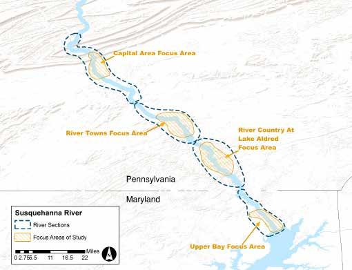
6 View from Highpoint Scenic Vista near Wrightsville, PA (Lara Lutz) ii themes through technology, integrated signage, and interactive and immersive experiences. Use events and promotional tools to raise the trail s visibility and encourage visitors to experience related sites and resources. Conserve lands to preserve natural and cultural features and to link and buffer existing sites. Complete and market early project successes to build momentum and generate additional funding for trail development. Create a regional story to encourage partnerships and promotion of resources between Maryland and Pennsylvania organizations. The planning team gave special attention to the presence of two other national trails that cross the lower Susquehanna region the Star-Spangled Banner National Historic Trail and the Washington-Rochambeau Revolutionary Route National Historic Trail. Opportunities to coordinate trail promotions and provide clarity for visitors is addressed in this plan where appropriate. For planning purposes, the river corridor was divided into four river sections. Each section contains one focus area, targeted for trail enhancements within two to five years. These sections are defined as follows: Section 1/Upper Bay Focus Area: From the Bay, including the area from Swan Harbor Farm to Mill Creek, to the Maryland/Pennsylvania line Section 2/River Country at Lake Aldred Focus Area: From the Maryland line to south of Fishing Creek and the Turkey Hill Overlook Section 3/River Towns Focus Area: From Long Level and the Turkey Hill Preserve to York Haven and Falmouth Section 4/Capital Area Focus Area: From York Haven and Falmouth to the confluence of the Juniata and Susquehanna Within the focus areas, anchor sites serve as primary locations for orienting visitors to the trails and for dispersing them to related opportunities. Site-specific recommendations for each of the river sections include: Trail destinations that offer public access to the water and basic visitor amenities and that have the potential for significantly contributing to trail-related experiences Linking routes on both land and water that currently or potentially connect visitors to resources and experiences along the trails Support services such as gas stations, boat ramps, restaurants, grocery stores, hotels, etc. Key messages that can be illustrated across the lower Susquehanna region include: Historic migration of fish and birds Landscapes that supported substantial Indian communities Crossroad for cultures (of Native American and European interactions) The Susquehanna as a transportation route Iconic viewsheds and evocative landscapes Innovative partnerships will be essential to realizing the full potential of this plan. The partnerships may involve activities ranging from marketing, fundraising, and program design to resource protection, technical assistance, and facility development. The Lower Susquehanna River Segment Implementation Plan is intended to be a living document, dynamic in adding new content and updating progress over the next two to five years. The implementation of the action items identified in the plan will create momentum along the trails and spur additional conservation, interpretation, and public river access at partner sites along the lower river and portions of the upper Bay.

7 Havre de Grace, MD (NPS Chesapeake) Chapter 1 The Lower Susquehanna Region & its Trails Introducing the Lower Susquehanna Region... 1 The Captain John Smith Chesapeake National Historic Trail... 2 Additional National Trails in the Lower Susquehanna Region... 3 Role of the National Park Service... 6 Health of the Susquehanna River and Chesapeake Bay... 6 Recreational Opportunities and Visitor Experiences... 8
8


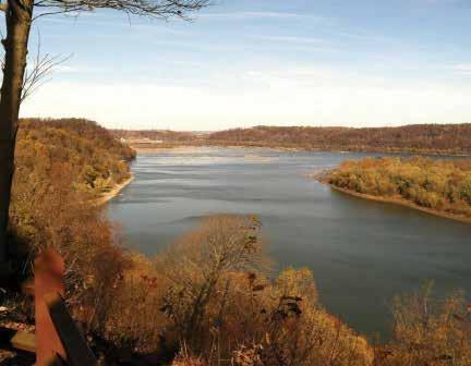
9 Chapter 1 The Lower Susquehanna Region & its Trails Introducing the Lower Susquehanna Region For the purposes of this plan, the lower Susquehanna region is defined as being located within a 74-mile river corridor, beginning with the confluence of the Susquehanna and Juniata rivers, just north of Harrisburg, and continuing south to the Susquehanna s mouth at the Chesapeake Bay near Havre de Grace, MD. It also includes a portion of the upper Bay that extends to Swan Harbor Farm in Harford County, MD, and Mill Creek in Cecil County, MD. The Susquehanna River is a major tributary to the Chesapeake Bay, representing 43 percent of the Bay s drainage area and 50 percent of its freshwater flow. The origins of the Chesapeake Bay can actually be traced to the river itself the Bay formed when the ancient Susquehanna River was gradually flooded by the Atlantic Ocean. Today, the Chesapeake Bay is the largest estuary in North America and one of the most productive in the world. It supports more than 3,600 species of plants and animals, including fish and shellfish, migratory waterfowl, and an array of mammals. Habitats within the 64,000-square-mile watershed range from upland forests to tidal marshes and swamps. The Susquehanna mirrors other Bay tributaries with its abundant fish and wildlife species and forested landscapes; the region provides many important economic, recreational, and educational resources for those who live, work, and travel here. first European explorer known to travel the river. He quickly found it unnavigable above the fall line and abandoned his plan to journey further upriver. The lower Susquehanna River also played an important role in American history. It protected the Continental Congress from the British during the American Revolution; during the War of 1812, British troops raided Maryland communities along its banks. The river slowed the advance of the Confederate Army in Pennsylvania during the Civil War and supported a canal system that helped fuel the economic development of the nation. Railroads along much of the river s eastern shoreline eventually replaced the canals, further expanding the economy. The development of four hydropower dams on the lower Susquehanna signaled a new era of power generation that began in the early 1900s and has forever changed the landscape in some stretches by creating lakes behind the dams, resulting in sections of limited access for visitors and challenging habitat for migratory fish. Despite changes in the surrounding landscape, the Susquehanna still The Sasquesahanocks inhabit up the chiefe Spring of these foure branches of the Bayes head, two dayes journey higher then our barge could passe for rocks yet we prevail with the interpreter to take with him another interpreter, to perswade the Sasquesahanocks to come visit us, for their language are different... The Sasquesahanocks river we call Smiths falls... Captain John Smith s journal July 1608 For thousands of years prior to European settlement, American Indians inhabited the lower Susquehanna region in temporal communities that became relatively permanent with the advent of agriculture. As a result, the region has significant American Indian archeological sites and is well known for its concentrations of petroglyphs in the lower Susquehanna River. In 1608, Captain John Smith became the Opposite: Urey Overlook along the Susquehanna River (Susquehanna Heritage) Left: National Trails Day at Conowingo Visitor Center (Lower Susquehanna Heritage Greenway) 1

10 Heaven and earth have never agreed better to frame a place for man s habitation, were it fully manured and inhabitated by industrious people. Here are mountains, hills, plaines, valleyes, rivers, and brookes, all running into a faire bay, compassed for the mouth, with fruitful and delightsome land. Captain John Smith, excerpted from a publication referencing his maps and observations while exploring the Chesapeake Bay, This illustration is an artist s depiction of Werowocomoco, an important American Indian site when the English arrived to establish the Virginia colony in the early 1600 s. Werowocomoco was home to the native leader Powhatan. (Rob Wood) 2 offers an abundance of iconic viewsheds, opportunities for fishing and boating, important habitat for migratory birds, and protected landscapes of cultural and natural significance. Largely because of the river, the lower Susquehanna region supports a myriad of land- and water-based recreational opportunities. It s a favorite spot for anglers and birders. Boaters enjoy the upper Bay, and the dam reservoirs provide additional opportunities for motorized boating and paddle craft. For example, the Conowingo Dam reservoir covers more than 8,600 acres and extends 14 miles upstream. The establishment of the Lower and Middle Susquehanna River Water Trails, as well as the Captain John Smith Chesapeake National Historic Trail, highlights the importance of boating and paddling to the region. Land trails also provide miles of hiking and biking experiences. More than 23 miles of recreational land trails are already in place in Maryland s Harford and Cecil counties. In Pennsylvania, Lancaster and York counties provide more than 22 miles of trails along the river corridor. The Mason-Dixon Trail follows the river from Manchester Township in York County, PA, to Havre Grace, MD, then crosses the river to Cecil County, adding another 80 miles of trail to the region. The Captain John Smith Chesapeake National Historic Trail The Captain John Smith Chesapeake National Historic Trail (Chesapeake Trail) takes its name and many portions of its route from the explorations of Captain John Smith on the Bay and its tributaries from 1607 to Established in 2006 as the first water-based national historic trail, it spans approximately 3,000 miles of waterways between Cooperstown, NY, and Norfolk, VA, and from Appalachian headwater streams to the Eastern Shore of the Bay.


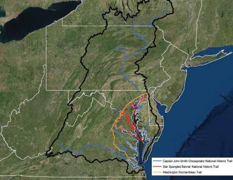
11 The promise of the trail is to help the region s residents and visitors experience, envision, understand and protect present-day resources that are reminiscent of what explorers and native inhabitants of the region may have experienced over 400 years ago. Specifically, its purpose is to: Top: Flag ceremony during War of 1812 celebration in Havre de Grace, MD (NPS Chesapeake) Bottom: Pinnacle Overlook in Lancaster County, PA (NPS Chesapeake) Interpret the natural history and contemporary state of the Bay and its tributaries Share knowledge about the American Indian societies and cultures of the seventeenth century and their modern descendants Commemorate Smith s exploratory voyages on the Bay and its tributaries in These goals are being accomplished by promoting and expanding water-based recreation in coordination with landbased sites along the trail and by conserving important landscapes and resources that support visitor experiences. Additional National Trails in the Lower Susquehanna Region Portions of two other national trails have a footprint in the Lower Susquehanna region. The Star-Spangled Banner National Historic Trail was established in 2008 to commemorate the people, places and events that led to the birth of the National Anthem during the War of The trail, coupled with the Star-Spangled Banner Scenic Byway, traverses approximately 560 miles of land and water routes in Virginia, the District of Columbia, and Maryland, along which British forces and American defenders traveled and fought. It traces the Chesapeake Bay and the Potomac, Patuxent, Patapsco, Susquehanna, Elk and Sassafras rivers, along with land routes stretching from Solomons Island to Washington, DC to North Point State Park in Maryland. The trail commemorates a historic travel route of significance to the entire nation; its land and water routes offer outstanding recreational opportunities along the historic roads and scenic waters of the Chesapeake Bay and its tributaries. The Washington Rochambeau Revolutionary Route National Historic Trail was established in 2009 as a network of land and water routes, traversing nine states and the District of Columbia, over which the American and French armies and navies traveled during the American Revolution. Sites and experiences along the route highlight its significance as both a domestic cross-cultural experience and a manifestation of the international war effort, integral to the birth of our nation. 3
12 4
13 National Trails in the Lower Susquehanna Region Captain John Smith Chesapeake National Historic Trail Takes its name and many portions of its 3,000-mile route from the explorations of Captain John Smith on the Chesapeake Bay and its tributaries from 1607 to Star-Spangled Banner National Historic Trail Commemorates the people, places, and events that led to the birth of the National Anthem during the War of Coupled with the Star-Spangled Banner Scenic Byway, it traverses approximately 560 miles. Washington-Rochambeau Revolutionary Route National Historic Trail Follows the routes of the allied American and French forces during the American Revolution at different times between June 1781 and December Summary of Trail Themes Summary of Trail Themes Summary of Trail Themes 1. Natural history and contemporary state of the Chesapeake: The Bay region of the 1600s was intensely rich and fertile, with abundant resources to support its native inhabitants. The Bay and its tributaries remain a significant natural and economic resource. Since the 1600s, the Bay and its rivers have suffered from the effects of natural and human impacts, but opportunities for restoration and preservation remain. 2. American Indians of the 1600s, who: Used sophisticated governmental systems, cooperative systems, political and military alliances, and elaborate trade routes; practiced the arts and architecture; and carried deeply held spiritual beliefs. Substantially influenced the fate of, and were dramatically influenced by, European explorers and the colonization of the region. 3. Smith s voyages on the Bay and its rivers: Smith s time in the Chesapeake is a story of adventure and survival, as Smith, his crew, and the colonists dealt with great hardships. Smith was employed by England and the Virginia Company to seek profits. Smith s detailed writings and maps spread the news of North America s abundant resources, accelerating European colonization. 1. Almost 30 years after gaining independence, Americans resisted an invasion by Great Britain, and military events in the Bay region became central to the outcomes of a three-year struggle that established a foundation for the United States economic independence and military strength. 2. During the War of 1812, citizens of the Bay region endured great political, economic, and emotional upheaval and faced personal choices that profoundly impacted domestic life, influenced the evolution of the national government and commerce, and had ramifications far beyond the battlefield. 3. In the early 1800s, the Bay region due to its central location on the eastern seaboard, network of navigable waterways, robust natural resources and fertile agricultural lands served as a hub for trade, industry, and government, making it a prime target for the British. 4. The United States flag and The Star-Spangled Banner anthem symbolizing the resilience of the new nation and the American character inspired a renewed sense of nationalism and endure today as icons of the United States. 1. The route is significant as a domestic cross-cultural experience: A critical time in the development of an American national identity. As a prime illustration of the American Revolution as a diverse effort. As a visible expression of the hope for independence and the gratitude that greeted the returning French Army on its march north in the summer of The route is significant as a manifestation of the international war effort: A symbol of the global character of the American War for Independence. The culmination of the critical contributions of France in the achievement of American independence. An example of joint Franco-America cooperation under Washington s overall leadership The first true acknowledgment of America as a sovereign nation. 5

14 Native Lands Park Trailhead at the Zimmerman Center for Heritage (Susquehanna Heritage) 6 Role of the National Park Service The National Park Service is responsible for leading the development of national trails and is an active partner in several Bay-related efforts, including land conservation, outdoor recreation, and stewardship outreach. Supporting federal legislation and agreements include the following. The National Trails System Act of 1968 [82 Stat. 919, Public Law ], as amended, creates a national system of trails to provide for the outdoor recreational needs of an expanding population and to promote the preservation of and access to the outdoor areas and historic resources of the nation. The act declares that trails should be established primarily near urban areas of the nation and secondarily within scenic areas and along historic travel routes. The purpose of the act is to provide the means for attaining these objectives by instituting a national system of recreation, as well as scenic and historic trails, and by prescribing the methods and standards by which additional components may be added to the system. The Chesapeake Bay Initiative Act authorizes the National Park Service to 1) identify, conserve, restore, and interpret natural, recreational, historical, and cultural resources within the Bay watershed; 2) identify and use collective resources sites for enhancing public education of and access to the Bay; 3) link sites with trails, tour roads, scenic byways, and other connections; and 4) develop and establish water trails comprising routes and connections to sites and other land resources within the Chesapeake watershed. Planning Documents: The National Park Service has produced Comprehensive Management Plans for the Chesapeake Trail and the Star-Spangled Banner Trail, which provide guidance for the Park Service and its partners to achieve the legislative mandates and visions for the trails and for Maryland s Star-Spangled Scenic Byway. Interpretive plans have also been completed for all three national trails that cross the lower Susquehanna region. The Washington-Rochambeau Trail has a strategic plan to guide the Park Service and its partners. Chesapeake Bay Watershed Agreement: The Chesapeake Bay Program has led and directed the restoration of the Bay since Bay Program partners include federal and state agencies, local governments, nonprofit organizations, and academic institutions. Several written agreements have guided these efforts. The Chesapeake 2014 Agreement established 10 related goals, including the addition of 300 new public access sites to the region s waterways and the protection of an additional 2 million acres of land. The National Park Service is responsible for fostering interjurisdictional collaboration for both of these goals and supports other initiatives that advance the Bay restoration. The role of the National Park Service is unique when dealing with national trails because many of the sites along the trail are not directly owned or managed by the federal government. They include parks, wildlife areas, museums, and historic sites that are under the jurisdiction of local governments and nonprofit organizations. Therefore, partnerships are crucial. Coordination with the management, development, and conservation strategies for these sites is essential in order to identify partnership opportunities for mutually beneficial projects and this is especially true for the lower Susquehanna region. Health of the Susquehanna River and Chesapeake Bay The health of the Chesapeake Bay and Susquehanna River has drawn much attention. The Chesapeake Bay Foundation s 2016 report card gave the Bay a C-minus. However, the report notes that the three indicator categories of pollution, habitat, and fisheries have improved, and the iconic blue crab score leapt the most dramatically. According to the Chesapeake Bay Program s Bay Barometer, between 2015 and 2016, the abundance of adult female blue crabs in the Chesapeake Bay increased 92 percent, from 101 million to


15 194 million. The 2015 Chesapeake Bay Watershed Report Card, issued by the University of Maryland, gives the Upper Western Shore (including portions of the Susquehanna River) a grade of C. The report notes that the shore has moderate ecosystem health, improved the most in total nitrogen and aquatic grasses and had a perfect oxygen score and states that the region is showing a significantly improving trend. The Susquehanna Flats near Havre de Grace, MD, is one of the largest beds of underwater grasses in the region and will continue to play a role in improving the health of the Bay: Because underwater grasses provide food and shelter for fish and wildlife, add oxygen to the water, absorb nutrient pollution, reduce shoreline erosion and help suspended particles of sediment settle to the bottom, their restoration will dramatically improve the health of the Bay ecosystem (Bay Barometer, ). However, few beds have been mapped in the Susquehanna River itself. Small areas of underwater grasses have been found below the Conowingo Dam at creek mouths and the islands between the dam and Port Deposit. The Susquehanna River has a large influence on the Bay, because it provides 50 percent of the Bay s fresh water. As a result, the Susquehanna is a large source of the nutrients that enter the Bay. Because the river falls rapidly within the Susquehanna Gorge and led to the development of four power plants, hydropower generation is a major factor in the river s health. The Conowingo Dam reservoir had historically trapped sediment and nutrients flowing downstream and prevented them from entering the Bay; however, recent studies indicate that the reservoir is now only trapping sediment for the short term. Sediment with attached nutrients now flow over the dam during large storm events and enter the Bay. Tropical Storm Lee in 2011 brought this issue to the forefront when an estimated 2 million tons of sediment came down the river into the Bay. Scientists assert that reducing upstream nutrient and sediment will have a more positive impact on the Bay than dredging the reservoir (Lower Susquehanna River Watershed Assessment, March 2016). In 2016, Pennsylvania s Department of Environmental Protection (DEP) declared a 4-mile section of the river where the river flows through parts of Cumberland and Dauphin counties from the mouth of the Conodoguinet Creek to the The impact of the Susquehanna River has on the Bay is hard to overestimate. Starting in Cooperstown, NY, and flowing 444 miles to the Chesapeake Bay, the Susquehanna River basin drains 27,500-square miles of land and contains more than 49,000 miles of rivers and streams. By the time it reaches the Bay, the river has an average of 18 million gallons per minute flowing in it State of the Bay Report Chesapeake Bay Foundation 7

16 The Susquehanna River Basin Commission formed the Lower Susquehanna Source Water Protection Group in 2013 to promote a collaborative approach to protecting sources of drinking water. More than 1.9 million people reside in the lower Susquehanna River sub-basin, with more than 4 million in the Susquehanna basin as a whole. These residents rely on the river as their primary or back-up source of drinking water. The partnership is focused on improving spill responses, promoting innovative solutions to stormwater issues, connecting best management practices to source water protection, enhancing water quality monitoring efforts, and assessing contamination risks. 8 The Susquehanna River, part of the Captain John Smith Chesapeake National Historic Trail, gives the public an opportunity to experience firsthand the connection with this magnificent watershed and its rich historical and ecological treasures. It provides the framework for DCNR to link the trail to our mission: enhancing recreation and tourism opportunities, conserving the ecologically sensitive habitats and forested buffers, and supporting the historical and cultural history of the Commonwealth s significant American Indian cultural landscapes. In partnership with County and local governments, land trusts, watershed organizations and our partners at the Susquehanna Heritage Area, the Susquehanna Greenway and the Susquehanna Riverlands Conservation Landscape; DCNR provides financial and technical assistance resources to enhance recreation facilities, conservation areas, and historical landmarks. Above: The Susquehanna River as it enters the Bay (Emily Myron) Lauren Imgrund, Deputy Secretary Pennsylvania Department of Conservation & Natural Resources mouth of the Yellow Breaches as impaired for recreation. DEP has also designated all 347 miles of the river in Pennsylvania impaired for fish consumption due to high levels of bacteria found in the water. The Pennsylvania Fish and Boat Commission continues to support the designation of impairment so that the US Environmental Protection Agency will require DEP to develop a restoration plan. Many federal, state, and local planning documents outline strategies for evaluating and improving the health of the Bay and the lower Susquehanna, including scientific analysis, zoning and development restrictions, and implementation of best management practices. The Lower Susquehanna River Segment Implementation Plan can contribute to the health of the river by enhancing residents and visitors connections to the river and encouraging a stewardship ethic. Recreational Opportunities and Visitor Experiences The lower Susquehanna region offers a range of visitor opportunities that embrace both land and water resources. Important visitor-related resources include: State-designated heritage areas Developed water trails throughout the region Existing sites that provide boat launches, swimming, fishing, camping, and wildlife viewing Hiking trails and bicycling routes Scenic byways and auto tour routes Heritage tourism sites Federal, state, and local parks/protected areas Visitor centers and contact stations Visitor support services including lodging, food service, rental equipment, etc. Chesapeake Bay Interpretive Buoy System (one buoy is located near Havre de Grace)

 Lower Susquehanna Heritage Greenway trail in Perryville, MD (Lower Susquehanna Heritage Greenway) Susquehanna Heritage: Part of the")
17 Two state-designated heritage areas bring attention to the varied visitor experience in the region: Lower Susquehanna Heritage Greenway: Part of the Maryland system of heritage areas, the Lower Susquehanna Heritage Greenway creates greater public access to the upper Bay for recreation and economic opportunity by encouraging a greater understanding of the significant role the upper Bay and its people have played in human history and by fostering links among heritage attractions of the waterfront communities. Anglers at the Bay (Lower Susquehanna Heritage Greenway) Lower Susquehanna Heritage Greenway trail in Perryville, MD (Lower Susquehanna Heritage Greenway) Susquehanna Heritage: Part of the Pennsylvania system of heritage areas, Susquehanna Heritage is focused on the river corridor in York and Lancaster counties. The mission of the organization is to enhance the region s quality of life and economic vitality by promoting the preservation, conservation, and interpretation of the river s cultural and natural heritage. Susquehanna Heritage s Zimmerman Center for Heritage serves as a visitor contact station for the Chesapeake Trail, as well as a trailhead for the Mason-Dixon Trail and Lower Susquehanna River Water Trail. The water trail, which is also managed by Susquehanna Heritage, extends from Harrisburg to the Broad Creek Access in Maryland. It provides a series of interpretative panels at many of the access locations, delineates points at which boaters and paddlers can access the river, and offers safety information about exploring the waterway with its hydro-electric dams. The Susquehanna Riverlands Conservation Landscape is implemented through a partnership of nonprofit organizations, businesses, and communities within York and Lancaster counties that share the Susquehanna River as a boundary. Designated by the Pennsylvania Department of Conservation & Natural Resources, a conservation landscape is a nontraditional strategy for government to target investment and engage with communities for the benefit of resource conservation and community revitalization. The Lancaster County Conservancy is the lead local agency. While public water access sites and private marinas dot the Susquehanna River and the upper Chesapeake Bay, some stretches of the river look as if they have been relatively undisturbed for generations. Susquehannock State Park, which includes Pinnacle Overlook, in Lancaster County, PA, is well known for its scenic overlooks. Susquehanna State Park in Harford County, MD, hosts portions of the Lower Susquehanna Heritage Greenway and several historic structures, including the Rock Run Mill, which is home to a new exhibit on the Bald Friar petroglyphs. The recent expansion of land trails has provided new opportunities for visitors and local residents to hike or bike along scenic segments of the river where access can be challeng- 9


18 Top: Chiques Creek Bridge on the Northwest River Trail (Susquehanna Heritage) Bottom: Lower Susquehanna Heritage Greenway Trail (Lower Susquehanna Heritage Greenway) ing. In Pennsylvania, the new Northwest Lancaster County River Trail has become a popular destination for bicycling and walking that also brings new attention to the local river towns. The Enola Low Grade Rail Trail offers hikers and bikers 5.25 miles to view the Susquehanna River in Manor Township. Hikers can also enjoy the river views from the less developed Mason-Dixon Trail on the York County side. The Mason-Dixon Trail offers opportunities to view and, in some cases, traverse lands that once supported the Susquehannock Indians. The Lower Susquehanna Heritage Greenway includes more than 23 miles of land trails in Harford and Cecil counties. The Lower Susquehanna Scenic Byway travels 33 miles on local and state roadways linking Havre de Grace to Perryville on the opposite shore. Many of these trails provide access to Important Birding Areas. Birders travel from all over the world to photograph bald eagles feeding at the base of the Conowingo Dam and migratory birds resting at Conejohela Flats. The river towns of the lower Susquehanna region offer public access to the river, visitor support services, and interpretive and educational opportunities. The three waterfront communities in Maryland also represent river-centric culture. The marinas, riverfront dining, river-related festivals, Havre de Grace promenade, and iconic bridges are all huge components of local cultural identity and major economic drivers. Havre de Grace offers opportunities to explore the Star-Spangled Banner Trail with interpretative signage at key sites. The Havre de Grace Maritime Museum s exhibit, Beyond Jamestown: Life 400 Years Ago, highlights Smith s 1608 voyage and his interaction with the Susquehannock. Perryville, site of Rodgers Tavern, has a connection to both the Star-Spangled Banner and Washington-Rochambeau trails. Port Deposit s new visitor center partners with Towson University on programming about the endangered map turtle. Susquehanna Heritage, based at the Zimmerman Center located near Wrightsville, provides programs about the Susquehannock Indians at adjoining Native Lands Park. Columbia Crossing offers a variety of programs ranging from environmental issues to local history. Visitor-related resources can also be found in Harrisburg, Pennsylvania s state capital and the largest city along this portion of the Chesapeake Trail. Harrisburg provides a unique opportunity to explore the themes of the trail through the Pennsylvania Historical and Museum Commission s cultural resources and exhibits, some of which relate to the earliest inhabitants of the Susquehanna River valley. 10

19 Lake Clarke, Lancaster County, PA (Susquehanna Heritage) Chapter 2 Creating the Lower Susquehanna Segment Plan Purpose of the Segment Plan The Planning Team and its Research A Vision and Goal for the Lower Susquehanna Segment Elements of the Segment Plan Orientation and Interpretation Trail Promotion and Support Services Public Access and Connectivity Resource Protection and Land Conservation... 19

20 Chapter 2 Creating the Lower Susquehanna Segment Plan Stakeholder meeting (Susquehanna Heritage) 12 Purpose of the Segment Plan The primary purpose of the Lower Susquehanna River Segment Implementation Plan is to illustrate how the Captain John Smith Chesapeake National Historic Trail could be enhanced along the portion of the trail that exists in the lower Susquehanna region. The plan identifies methods for making the trail more visible and meaningful for visitors, including the effective interpretation of diverse stories. Varied and compelling hands-on experiences are highlighted as a way to advance the trail and adjoining conserved landscapes as educational, recreational, and tourism assets for the region. Key to this planning effort is the recognition that the Chesapeake Trail is one of three national historic trails in the lower Susquehanna region; the others are the Star-Spangled Banner National Historic Trail and the Washington-Rochambeau National Historic Trail. These two trails also have the potential to provide greater opportunities for new and enhanced visitor experiences and would benefit from a more detailed planning effort. Both have Comprehensive Management Plans that focus on broad strategies for the entire length of the trails (collectively many thousands of miles), but the Washington- Rochambeau trail would especially benefit from more detailed, local-level plans. Therefore, where appropriate, this Segment Plan for the Chesapeake Trail also includes enhancement opportunities for the Star-Spangled Banner and Washington- Rochambeau trails. The Segment Plan is a planning document and does not represent final development or management decisions of the National Park Service or other site managers. It represents a consensus on trail-wide and site-specific recommendations, but does not pre-determine final decisions related to individual projects. It assumes new ideas will surface and projects will come to the fore in the fullness of time. Innovative partnerships are essential to realizing the full potential of this plan. The partnerships may involve activities ranging from marketing, fundraising, and program design to resource protection, technical assistance, and facility development. The Planning Team and its Research The Lower Susquehanna Segment of the Chesapeake Trail is defined as the Susquehanna River from its confluence with the Juniata River just north of Harrisburg, to its mouth at the Chesapeake Bay near Havre de Grace, MD, and the northern portion of the upper Bay from Mill Creek to Swan Harbor Farm. The team that conducted the planning process and created this report included representatives from the National Park Service Chesapeake, Maryland Department of Natural Resources, Pennsylvania Department of Conservation and Natural Resources, Lower Susquehanna Heritage Greenway, Susquehanna Heritage, Chesapeake Conservancy, and the Susquehanna Riverlands Conservation Landscape, represented by staff from the Lancaster County Conservancy and Lancaster County Planning Commission. The team held a series of meetings and interviews with


21 stakeholders to gather insight and ideas. Interviewees included tourism officials; local, state, and federal government representatives; site managers; private sector tour operators; and non-governmental organizations. Interviewees concluded that to make the trails more visible and meaningful for visitors, several conditions and activities are necessary: Cultivate the areas with significant trail-related resources that already have visitor services and operational capacity. Connect people to trail-related places, stories, and themes through technology, integrated signage, and interactive and immersive experiences. Use events and other promotional tools to raise the trails visibility and encourage visitors to experience the resources associated with each trail. Conserve lands to preserve natural and cultural features or landscapes and to link and buffer existing sites. Complete and market early project successes to build momentum and help generate additional funding for trail development. Create a regional story to encourage partnerships and promotion of resources between Maryland and Pennsylvania organizations. The team also assessed resources within the river corridor and made numerous site visits. Based on this assessment, the following planning approaches were taken to identify potential near-term enhancements to the trails along the lower Susquehanna: Identify river sections with distinct characteristics, demographics, and jurisdictional boundaries. Within each section, define one or more focus areas targeted for relatively rapid trail enhancements. Outline a set of strategies for enhancing these focus areas and connecting, promoting, interpreting, protecting, and further developing the trails. Address additional areas for trail enhancements. Recognize associated locations that can provide support services. A Vision and Goal for the Lower Susquehanna Segment The planning team developed vision and goal statements for improving the visitor experience along the Lower Susquehanna Segment of the Chesapeake Trail. Vision: The Chesapeake Trail in the lower Susquehanna Left: Chesapeake Trail Visitor Contact Station at the Zimmerman Center for Heritage in Wrightsville, PA (Susquehanna Heritage) Right: Havre de Grace Maritime Museum (Havre de Grace Maritime Museum) 13

22 region is first and foremost graced by the river itself a spectacular resource with extensive, intrinsic recreational value. The trail helps maximize its recreational potential through enhancement of access sites, orientation, and interpretation that guides residents and visitors in their enjoyment of the river. Recreation and recreational learning experiences cultivate a sense of place and love of community; they deepen people s connection with the river and increase their interest in its stewardship. By providing better physical and interpretive infrastructure and by harnessing the region s rich history through a storied experience, we help shape a vibrant future for the lower Susquehanna region. The Chesapeake Trail provides an economic stimulus for local communities and aids in the protection of resources important to local quality of life. It connects scenic and historical sites along the river and shoreline, crossing geographic boundaries, for the recreation and educational benefit of paddlers, boaters, cyclists, hikers, and motorists. Serving as a regional outdoor classroom, the trail promotes awareness of the natural and cultural attributes through memorable, sensory-rich experiences that enhance community pride in the Susquehanna River and Chesapeake Bay. Goal: This Segment Plan presents a shared vision for enhancing the Chesapeake Trail in the lower Susquehanna region, including collaborative opportunities with the Star-Spangled Banner and Washington-Rochambeau trails, in order to elevate their stories and advance the trails as assets for the region. This plan outlines specific recommendations to expand visitor experiences, land conservation, and public access to the water. 14 Implementation is predicated on coordinated recommendations from regional partners fully cognizant of existing conditions, assets, and opportunities. The recommendations envision the trails being brought to life through interpretation, programming, and public information at river access sites, beautiful vistas, recreational resources, and ecologically and historically significant sites. Attractive linear parks, pathways, and scenic driving routes will connect and provide access to the important places along the trail. Land conservation should take place to support these goals and preserve the regional story; visitors anywhere in the lower


23 Notes on the Segment Plan Recommendations All of the recommendations outlined herein are based on site analyses, focus group meetings, and input from stakeholders. Individual park and site manager recommendations for proposed actions also informed the Segment Plan. The actions were identified as being potentially viable within the next two to five years. This is not an all-inclusive list of potential enhancements, and the list is not static; new ideas and opportunities will develop over time. Also, while the river should be viewed as a whole, actions are often locally based; therefore, the trails should be considered in their entirety and as well as how each action builds on the entire trail experience. The National Park Service does not own any parcels of land in the project area. Therefore, these recommendations are not directly for Park Service actions; rather, they are actions that partners might undertake to enhance the trails along the lower Susquehanna River. This plan is meant to enhance the physical and virtual connections of many publicly accessible lands along both shorelines, which include federal, state, county, municipal, utility companies, and nonprofit partners. All action items in the plan should be understood to be reflective of the individual site s mission and objectives, which are subject to the political and financial shifts that impact staffing and funding. While all of these proposed actions have the potential to enhance the trails, some might also negatively impact historic properties and native vegetation through ground disturbance and the addition of non-historic elements to historic settings and cultural resources. Serious consideration of site resources and characteristics should be weighed against increased public use, land conservation opportunities, and other cumulative impacts. Any recordation or survey of sites, archeological, architectural, or cultural landscapes should be filed with the appropriate state historic preservation office. In all cases, care should be taken to ensure the avoidance of archeologically sensitive areas, populations of state-listed rare plant species, and globally rare plant communities. Susquehanna region should recognize that they are experiencing a larger landscape of cultural, natural, and historic significance. Elements of the Segment Plan For planning purposes, the Susquehanna river corridor was divided into four distinct river sections based on shared geography, visitor usage patterns, jurisdictional boundaries, and existing transportation infrastructure: Section 1: From the Bay, including the area from Swan Harbor Farm to Mill Creek, to the Maryland/Pennsylvania line Section 2: From the Maryland line to south of Fishing Creek and the Turkey Hill Overlook Section 3: From Long Level and the Turkey Hill Preserve to York Haven and Falmouth Section 4: From York Haven and Falmouth to the confluence of the Juniata and Susquehanna rivers Each river section contains one focus area, targeted for trail enhancements within two to five years. Focus areas already contain resources and stories associated with the trails and, in some cases, significant, trail-evocative landscapes. Each focus area provides a variety of immersive visitor experiences opportunities for people to fully engage in the environment and/or an activity. Within the focus areas, anchor sites serve as primary locations for orienting visitors to the stories and resources associated with the trails and for dispersing visitors to related opportunities. These sites are staffed, provide visitor amenities and often public access to the water, receive high visitation, and have the potential to offer trail-related experiences via existing and/or expanded programming and development. Additional elements of this plan include: Top: Havre de Grace, MD (Susquehanna Heritage) Middle: Tappahannock kiosk (NPS Chesapeake) Bottom: Susquehanna State Park, MD (Susquehanna Heritage) 15

 16 Trail destinations that offer public access to the water and basic visitor amenities and that have the potential for significantly contributing to trail-related experiences via")
24 In 2013, the Star-Spangled Banner bicentennial was celebrated throughout the Chesapeake Bay with a series of programs and events along the Susquehanna, including the reenactment of the engagement with British soldiers at Havre de Grace. (NPS Chesapeake) 16 Trail destinations that offer public access to the water and basic visitor amenities and that have the potential for significantly contributing to trail-related experiences via existing or expanded programming and development Linking routes on both land and water that currently or potentially connect visitors to resources and experiences along the trails Support services that include commercial services and supplies (mass transit operations, private marinas, boat ramps, restaurants, grocery stores, hotels, etc.) and may currently or potentially offer public access to the water, immersive visitor experiences, and/or information pertaining to local destinations Orientation Orientation serves travelers before and during their trail visits. Web-based resources (such as FindYourChesapeake. com) provide basic site information, directions, maps, visitor opportunities, and pertinent regulations. Publications, printed maps, kiosks, and contact stations provide overviews of visitor facilities, services, programs, and safety information. Staffed visitor centers offer similar information, along with personalized assistance, orientation programs, films, and exhibits. Wayfinding devices include trail identifier signs along roadways and directional signs leading to and within the sites. The National Park Service has developed a Guide to Terminology for the Captain John Smith Chesapeake National Historic Trail to assist partners developing brochures, waysides, exhibits, and other media for the public. To maximize efficiency and consistency along the national trails, the Park Service has also developed standardized orientation panels for the Chesapeake and Star-Spangled Banner trails; one panel provides an overview of the trail, while a second conveys more detail related to trail themes and/or visitor opportunities. In many locations, a third panel conveys regional or site-specific information. Interpretation Interpretive services and products further involve visitors in the stories, resources, and experiences associated with the trails. Further investments are needed to develop placebased, trail-related concepts and stories to provide holistic interpretive experiences that reflect the richness and diversity of the region s natural and cultural heritage. Interpretive programs and self-guided experiences help visitors learn about historical features and events, various cultures, wildlife and the environment, and the principles of conservation. Personal interpretation, including guided tours, presentations, workshops, demonstrations and living history programs, actively engage visitors in learning and discovery. For example, the National Park Service has partnered with the National Park Conservation Association and Susquehanna Heritage to give fifth-graders a canoeing experience with a Chesapeake Trail interpretative program. According to tourism officials and a membership survey conducted by the American Canoe Association (March 2014), some travelers prefer suggested routes ; therefore, this plan includes trail itineraries. Itineraries suggest specific routes and describe associated landscapes, prominent sites, and visitor amenities. They also provide practical information regarding water access, travel distances, area conditions, and visitor safety. The plan suggests opportunities to create new itineraries or update/expand existing itineraries in coordination with trail sites and nearby communities. Guide training and supporting materials would optimize visitor opportunities within the trail corridors. Guided tours may be provided by agencies, nonprofit organizations, or businesses. The plan describes the development of shared training and materials that would support such tours. The

25 National Park Service has initiated a Visitor Readiness Training Program for the Chesapeake and Star-Spangled Banner trails; the program will target staff at trail sites, outfitters, and hospitality venues. NOAA s smart buoy system provides water and weather data along with trail-related interpretive narratives. The buoy on the Susquehanna River near Havre de Grace provides a summary of Smith s voyage up the Susquehanna to the falls and interaction with American Indians; geographic, flora, and fauna details; and links to local resources. Visitors using a brochure about the Lafayette Trail for a self-guided tour, can see many of the historical homes and buildings in Havre de Grace. In addition, the city offers a brochure featuring structures that existed at the time of the War of Across the river, Perryville has a signed walking trail detailing events there during the War of Trail Promotion Raising awareness of the national trails with varied audiences is an important, on-going effort. Effectively communicating with potential visitors involves: A visible trail presence at key sites and along travel routes, as well as on the Internet and mobile devices Events and programs designed to draw targeted audiences to the trails Strategic marketing and promotional activities by agencies, tourism organizations, and the private sector The trails presence on the Internet is established through their links to The National Park Service promotes trail sites, events, trip ideas, and planning tools through The Chesapeake Conservancy promotes events and trip planning through Trips and Tips, found at Susquehanna Riverview ( a 360-degree virtual tour of the river, provides detailed view of launch areas, scenery, and river hazards. The Park Service, Chesa- peake Conservancy, and local partners are also developing a new website called Paddle the Susquehanna. The website, expected to launch in 2018, will consolidate information on paddling the river that is currently found on a myriad of websites. Further investments in social media, blogs, and apps are important to advancing the national trails. The Chesapeake Roving Ranger, a joint program between the National Park Service and Chesapeake Conservancy, serves as the mobile visitor contact center for the Chesapeake Trail. The purpose of the vehicle is to raise awareness of Bay resources and Chesapeake Trail through exhibits and interpretive programs and to provide an avenue to reach new potential trail users, stewards, and donors. Visitors can collect a National Park passport stamp, pick up a trail brochure, participate in interpretive programs, or become a Junior Ranger. The vehicle will appear at Chesapeake Trail locations and at public events and festivals related to the natural and cultural heritage of the Chesapeake Bay. The National Park Service and its many trail partners have also developed numerous programs and special events to draw visitors to the trails. Festivals, river sojourns, regattas, and challenge events are among them. Strategic marketing and promotional efforts will be most effective when organized and led by tourism officials along the Susquehanna, in collaboration with other trail partners. Support Services A variety of services are needed to augment visitor experiences along the trails. Residents and travelers often require guides, food, lodging, equipment rentals, and other ameni- Susquehanna Heritage and NPS Chesapeake collaborate with a local outfitter to provide Every Kid in the Park, a full-day field trip for fourth graders. The trip provides a guided tour of Native Lands County Park, an introduction to the 18th-century home that serves as headquarters for Susquehanna Heritage, and a stream study on a tributary of the Susquehanna River. Mary Jo Moczulski, principal of Canadochly Elementary School, called the field trip a gift to the community as it focuses on the special resources in the students own backyard. (Susquehanna Heritage) 17


26 Top: Susquehanna Museum at the Lockhouse, Havre de Grace, MD (NPS Chesapeake) Bottom: David R. Craig Park, Havre de Grace, MD (NPS Chesapeake) 18 ties. A robust network of providers ensures more holistic visitor experiences and may result in repeat and/or lengthier trail visits. Commercially guided outings for boating, paddling, hiking, cycling, and heritage tours offer opportunities for people to experience the national trails particularly visitors who may be unable or reluctant to do so on their own. Several touring companies already provide these services in the lower Susquehanna region. Public and private marinas provide launches, dock facilities, boat slips and moorings, fuel, boat repairs, rentals, and information that enable people to access and enjoy various sections of the national trails. Conveniently-located overnight accommodations are an essential component of the national trails network. They include hotels, motels, bed-and-breakfast establishments, and campgrounds. Stakeholder discussions identified a need for additional water-accessible camping areas. Many trail users will benefit from other commercial services, including restaurants, grocery stores, equipment sales, rentals and repairs, and general merchandise. Public transportation services, including buses, ferries, and shuttles, are also important. These types of transportation can cultivate cross-river experiences. Public Access and Connectivity Along the Susquehanna, expanded or enhanced access to the trail, the river, and its shorelines will broaden the array of opportunities for visitors and likely increase overall use and attract new audiences. Increased land-based options can be achieved through the development of new or expanded hiking, biking and/or equestrian trails, site-specific driving tours and associated trailheads, parking areas, and other amenities. Reaching the opposite shore by land or water transportation is challenging in many sections of the lower Susquehanna. Pedestrian access on existing bridges is either non-existent or, in most cases, unsafe. Water taxi service between river towns does not exist but was frequently mentioned during the stakeholder process as one way to increase river town tourism in both Pennsylvania and Maryland. Initiatives are underway to study this issue. A water taxi workgroup has been formed with the municipalities associated with the Lower Susquehanna Heritage Greenway. The Lower Susquehanna Heritage Greenways and others are also working with Amtrak on the plan to replace the railroad bridge between Havre de Grace and Perryville and the opportunities to support water taxi service through that project. Finally, Susquehanna Heritage has received funding for a water taxi feasibility study within the River Towns Focus Area. Many areas lack water-accessible camping facilities, hindering extended paddling excursions. The development of new or expanded soft and hard launches and landings, dock slips, floating docks, boat-in camping areas, and associated amenities will facilitate paddling, boating, and overnight use. New or expanded piers and shoreline fishing areas will increase access for anglers. Additional observation platforms and overlooks are necessary to extend visual access to the water. Increased connectivity will enhance the national trail network along the Susquehanna. Seamless visitor experiences, with numerous physical linkages between various destinations and services, will provide optimal opportunities for trail users. Strategies for improving connectivity include: Improving sections of existing trails (through rerouting, widening, or resurfacing) to allow for more varied use as appropriate or developing new trails to close gaps in existing land routes Establishing new water trail segments to connect national trail components and/or link them with local water trails Acquiring properties or easements in order to connect key sites Supporting development of expanded or improved connector roads and multiple transit options including mass transit

27 Supporting the development of water based transportation systems Resource Protection and Land Conservation Resource conservation encompasses a broad set of actions intended to conserve or restore historic, cultural, and natural sites contributing to the quality of visitor experiences associated with the national trails. The identification of the special places that enrich the visitor experience will be part of a resource protection and conservation strategy. However, the national trails have varying purposes, significance, and users, thus requiring a range of protected resources and landscapes. Kayakers on the Chesapeake Trail may be looking for take-out points where they can explore nature preserves and wildlife areas, while a bus-tour group may be interested in the historic sites in river towns associated with the Star-Spangled Banner or Washington-Rochambeau trails. Visitors on the Susquehanna will encounter tracts of relatively undeveloped shoreline that contribute to their trail High-Potential Trail Segments The Chesapeake Trail s Comprehensive Management Plan defines high-potential route segments as those that have a greater than average aggregation of trail-related resources within the trail corridor. The lower Susquehanna segment is identified among them. Trail-related resources include the following: High potential historic sites Visible shoreline generally evocative of the early 1600s Other voyage stops Indigenous Cultural Landscapes Additionally, a high potential route segment must have the following: Sites with public access to the water Capacity to support a high quality recreation experience, defined as combining water-and-landbased recreation experiences. However, much of this land is privately owned and not open to the public; it is also vulnerable to land use change and development. Utility-owned lands, some of which are open to the public, may see a change in land use as the result of the relicensing process for Conowingo Dam. In either case, additional landscape conservation within the Susquehanna corridor would help safeguard the visitor experience. Existing strategies As summarized in Chapter 1, the National Trails System Act and supporting planning documents provide guidance for protection and conservation of trail-related resources. The act also recognizes the importance of state and metropolitan trails, as well as the relevance of protection strategies in both national and regional contexts. Policy guidance for resource protection is also provided in other federal legislation such as the National Historic Preservation Act, National Environmental Policy Act, and Endangered Species Act. Several additional documents recommend protection strategies for national trails and outline areas where natural resources should be protected, including the Comprehensive Historic American Indian town sites Cross-marker sites, where Smith reportedly placed brass crosses to mark the extent of his exploration Presence of protected lands Proximity to Chesapeake Bay Gateways and Trails partner sites The long-standing public demand for increased access to the water in the region is addressed in the Chesapeake Bay Watershed Public Access Plan, developed in 2011 by the National Park Service in collaboration with watershed states. The plan outlines ways to increase public access to the Bay and its tributaries, with a target of creating 300 new access sites by Feedback related to the draft plan indicated people want more places along the water to walk, sit, play, picnic, camp, swim, fish, watch wildlife, and launch canoes, kayaks, paddleboards, sailboats, and powerboats. 19

28 associated with the battle at Yorktown during the Revolutionary War; and relevant archeological sites. Trail-related protection strategies within the plans include: Conserving local and regional natural resources and open space in rapidly developing areas Providing connections between ecological islands or hubs Preserving cultural landscapes Protecting archeological resource and historic sites, and high potential historic sites and (land and water) segments Providing public access to evocative places and offering recreational opportunities The Chesapeake Large Landscape Conservation Partnership engages dozens of organizations and local, state, and federal agencies to advance conservation efforts. Milestones include creating Landscope Chesapeake ( chesapeake), a mapping tool reflecting conservation priorities, and advancing Indigenous Cultural Landscapes, an effort to document landscapes evocative of the natural and cultural resources supporting American Indian lifeways and settlement patterns. 20 Management Plans that the National Park Service created for the trails. The Comprehensive Management Plans for the Chesapeake and Star-Spangled Banner trails embrace historic, cultural, and natural resources, and promote resource conservation combined with providing quality outdoor recreational opportunities. They describe significant resources, including evocative landscapes and high potential route segments and historic sites, and prescribe recommended protection strategies. Nationally significant resources associated with one or more of the national trails include: the route of Smith s voyages and places cited by him; sites of American Indian towns of the 1600s; original routes of travel, battlefields, and historic structures associated with the War of 1812 in the Chesapeake region; original routes of travel and historic structures The Indigenous Cultural Landscape The concept of an Indigenous Cultural Landscape (ICL) is outlined in the Chesapeake Trail s Comprehensive Management Plan. ICLs comprise the cultural and natural resources that supported the historic lifestyles and settlement patterns of an Indian group in its totality, as well as the places important to contemporary tribes culture and heritage. The term attempts to recognize that American Indian places were not confined to the sites of houses, towns, or settlements, and that their view of one s homeland is transient and holistic rather than fixed in time and compartmentalized. Two projects were undertaken to define a High Probability ICL in the lower Susquehanna River region. Contact Period Landscapes of the Lower Susquehanna River mapped cultural resources along the lower Susquehanna. An ICL was defined for the Susquehannock and Shenks Ferry peoples that covered the river corridor from above Harrisburg to the Muddy Run Reservoir. Two areas were identified in Maryland, one from the former site of the Bald Friar petroglyphs to about Smith s Falls and the second around Garrett Island. The report also recommended sites where Chesapeake Trail interpretation could take place and identified several overarching themes: the richness of the

29 ecosystem; convergence and exchange; and the river corridor as a landscape of change. Kayakers on the Susquehanna River (Susquehanna Heritage) A second project, led by Dr. Katie Faull of Bucknell University, resulted in the report Indigenous Cultural Landscapes Study for the Captain John Smith National Historic Trail: the Lower Susquehanna Area. This report further refined the ICL of the lower Susquehanna as two ICL landscapes: one within the viewshed from the Conowingo Dam and the Susquehannock Fort Mennock in Maryland, and the second within the viewshed of Highpoint Scenic Vista and Recreation Area in Pennsylvania. Conservation Strategy The Conservation Strategy developed for the Chesapeake Trail in 2013 assesses resources contributing to the trail experience and uses a scorecard to identify focus areas for resource protection. It also describes a partnership action model as a guiding framework for resource protection initiatives. This strategy can serve as the foundation for developing a resource protection strategy for the lower Susquehanna region that can address high priority protection goals and specific initiatives in detail. Multiple Property Documentation Form The National Historic Preservation Act of 1966 created the National Register of Historic Places, a listing of properties that meet established criteria and have documented regional and/or national significance. A Multiple Property Documentation Form (MPDF) can be developed to provide an overall framework for the nomination of individual properties or groups of properties that relate to historic patterns or trends within a particular geography. The National Park Service is working to identify properties or groups of properties associated with the Chesapeake Trail that could inform the development of an MPDF. Evaluation of the trail s eligibility for the National Register could facilitate Section 106 of the National Historic Preservation Act and inform project planners about resources that should be considered in project alternatives so as to avoid or minimize adverse impacts on the resources. Viewshed Analysis The size of the river and the fact that much of its shoreline is still very rural can give the impression of a large, protected landscape. In reality, the views and natural areas seen on much of the lower river corridor could easily be erased through development. The National Park Service, in collaboration with the Chesapeake Conservancy, has conducted two viewshed analyses for the lower river. The first evaluated forest and wetland cover along the shoreline. The lower Susquehanna in Maryland, for example, has only 5.1 percent of the shoreline protected by forests or wetlands. The second analysis evaluated the viewshed of overlooks along the river. The review included an overlay on a GIS parcel layer to determine which parcels of land can be seen from a particular overlook. The analysis showed a significant number of undeveloped parcels not permanently protected, but on which these iconic views depend. Many are within Indigenous Cultural Landscapes. Visual access to undisturbed lands in lieu of public recreation access can provide a connection between the user, conservationist, and cultural resources in the landscape. Protection of these viewsheds could provide this connection, create additional opportunities for interpretation, and positively impact the health of the river and the Bay. The Envision the Susquehanna initiative conducted a telephone survey as part of its community engagement process. The survey revealed that in almost every region, more than half of the residents reported relaxing in or next to the river, visiting a park, biking or walking, and viewing wildlife within the last year. Numerous groups working across the watershed agree that recreation and public access provide a connection between residents, visitors, and the natural and cultural resources of the Susquehanna, building appreciation for, and therefore stewardship of the river. 21

30 Rodgers Tavern, Perryville, MD (Susquehanna Heritage) Envision the Susquehanna The Chesapeake Conservancy is the backbone organization for Envision the Susquehanna. The resulting document, A Vision for the Susquehanna River Watershed, provides cross-cutting recommendations for the Susquehanna River that address several of the purposes of the Chesapeake Trail and could be applied to the lower Susquehanna region: 1. American Indian Priority Work with active American Indian communities nearby to build a voice for American Indian history and culture. Document and protect the petroglyphs. Encourage the stewardship and celebration of the region s American Indian history and culture through K-12 education programs and cultural heritage tourism. Protect key viewsheds to preserve interpretive opportunities. 2. Recreation and Public Access Priority Connect river communities physically with greenways and trails and contextually with consistent interpretive messaging for a cohesive visitor experience. Support local visitor contact centers with locally relevant interpretive materials. 3. Wildlife Habitat Priority Evaluate and prioritize habitat connectivity improvements. Work with utility companies to prioritize fish passage for keystone and iconic aquatic species. Celebrate the lower Susquehanna as an important migratory bird flyway and migratory fish route by increasing public access for birding and fishing. Local Conservation Planning Conservation in the lower Susquehanna River region has also received significant attention from state and regional organizations. State and local planning efforts continue to support opportunities for resource protection and land conservation. As a result of this ongoing attention, multiple planning documents have been published about the lower Susquehanna. Where appropriate, these plans were reviewed as part of the segment planning process to ensure that local initiatives would be incorporated. Heritage Areas: Both states support heritage area programs, supported by strategic plans. Two heritage areas exist in the lower Susquehanna: Susquehanna Heritage Area in Pennsylvania and Lower Susquehanna Heritage Greenway in Maryland. Both have strategic plans that outline strategies for resource protection and improving the visitor experience. Statewide Outdoor Recreation Plans: Both states have developed Outdoor Recreation Plans that include guidance on land conservation and development of recreational assets. Plans are developed every five years and qualify the states for Land and Water Conservation funds. County Open Space and Recreation Plans: Several county-level documents address land preservation, natural resource protection, and recreation goals for counties and local communities in the region. Lancaster, Dauphin, Cumberland, Perry, and York counties have open space, greenways, and recreation plans that outline goals for protecting critical landscapes and evaluate recreational needs. Other county-level plans include Harford County s comprehensive plan, called Harford Next; the Harford County Parks and Recreation Department s Land Preservation, Parks and Recreation Plan; and Cecil County s Land Preservation Parks & Recreation Plan. Other resource and conservation strategies developed or endorsed by the partners engaged in this planning process should be consulted in an effort to assist in the attainment of resource conservation goals within the Chesapeake watershed. 22
 Connectivity... 27 Trails Promotion and Services.")
31 Flatwater Challenge at Indian Steps Museum, Airville, PA (Susquehanna Heritage) Chapter 3 Cross-Cutting Recommendations Key Messages Orientation and Interpretation New/Enhanced (Physical) Connectivity Trails Promotion and Services Land Protection and Conservation... 38
32 24


33 Chapter 3 Cross-Cutting Recommendations This chapter provides guidance on broad-based actions intended to raise the visibility and usability of the Chesapeake trail along the lower Susquehanna River, as well as the Star-Spangled Banner and Washington-Rochambeau trails where appropriate. It considers the lower Susquehanna region as a whole and proposes cross-cutting actions that affect all four geographic sections of the river. These cross-cutting actions could be applied throughout the river corridor as appropriate. Chapter 4 describes site-specific recommendations for each of the river sections. The recommendations in this chapter include both key messages and actions. For ease in implementation and tracking, they are presented in five categories: 1) Orientation and interpretation 2) New/enhanced (physical) connectivity 3) New/enhanced public access 4) Trails promotion and services 5) Land protection and conservation Key Messages The Chesapeake Trail has several key messages that can be illustrated across the lower Susquehanna segment of the trail. These include: Historic migration of fish and birds Landscapes that supported substantial Indian communities Crossroad for cultures (of Native American and European interactions) The Susquehanna as a transportation route Iconic viewsheds and evocative landscapes Orientation and Interpretation This plan does contain recommendations for interpretive and orientation signs which will help bring the trails to life. However, signs must be considered in the context of existing signage and how additional information might best be presented. A common issue expressed at all of the stakeholder meetings was a concern over too much signage. Some sites already have an abundance of signs. Adding more could be both distracting and confusing for visitors. Decisions regarding signage are at the discretion of the site managers who will consider where best to place new signs; the potential of combining information, where appropriate, onto the same display panel or kiosk; the use of electronic or public art as signage; eliminating outdated signage; and/or exploring other forms of media as a means of sharing information. It is important that all displayed information accurately reflect the history, stories, and resources of the site. Orientation kiosks: Multi-paneled kiosks, introducing the three trails, could be installed at prominent sites within the river corridor. (Note: Many kiosks are already in place for the Star-Spangled Banner Trail.) Sites could include federal, state, and local parks; wildlife refuges, historic sites, and private marinas, campgrounds, and other facilities open for public use. Interpretive panels highlighting each of the parks in a river section could give context to how the individual sites fit into the larger stories of the three national trails, as well as referring visitors to additional sites in the area. Interpretive signs: Single-panel interpretive signs, reflecting the natural and cultural richness of the area and keyed back to the trails, could be installed at important observation sites, smaller historical sites and parks, boat launch areas, and at publicly accessible private facilities. Top: View from Turkey Hill trail, Lancaster, PA (Susquehanna Heritage) Bottom: Historic mill at Susquehanna State Park, Hartford County, MD (NPS Chesapeake) 25


34 Top: A trail marker paired with water access signage, Seaford, DE (NPS Chesapeake) Bottom: Washington-Rochambeau Trail banner, Philadelphia, PA (NPS) 26 Wayfinding signs: To help visitors locate trail segments, sites, and other amenities, and to easily follow travel routes, wayfinding signs should be installed at appropriate locations. In coordination with state departments of transportation and local governing bodies, such signs may be located at key intersections. They could also be installed within smaller trail sites where kiosks and other interpretive signs may not be appropriate. A coordinated on-road and off-road wayfinding system would solidify the region with a broader identity rather than a collection of interesting sites. Maps and guides: Maps and guides for each trail could be made available at the anchor sites and at select trail destinations, outfitter locations, and local community facilities. The Susquehanna Riverlands and Lower Susquehanna Heritage Greenway maps cover river sections 1-3. The lower and middle Susquehanna River Water Trail maps and guide cover river sections 2-4 but are in need of an update. Paddle the Susquehanna River, an initiative of the National Park Service and Chesapeake Conservancy, will provide coverage for the entire segment plan area. The initiative is currently underway and looking for additional partner engagement. Exhibits: Visitor center exhibits throughout the region could be enhanced with information related to the national trails. Other permanent and/or temporary exhibits could be placed at federal, state, and local parks; national wildlife refuges; historic sites; and regional and local information centers. Audio tours/podcasts: Audio tours/podcasts could be developed or revised. Potential topics include bird species, historical and contemporary fishing techniques, significant historical events, and American Indian cultures. On-site interpretation: Many of the region s parks, historical sites and museums offer interpretive programs. By partnering with the National Park Service, these programs could be expanded to include national trail themes. Off-site interpretation: To help visitors gain an understanding of significant cultural and historical resources and events related to non-accessible lands, stories could be told from nearby accessible properties. For example, the story of the village site that was occupied by the Susquehannock during the time of Smith s voyages could be told at Blue Rock Heritage Center and Native Lands Park. The Pennsylvania State Museum and the Maryland Historical Trust have resources and exhibits that could make the trail more visible and meaningful for visitors at off-site locations. Boating/paddling itineraries: Itineraries for paddlers and small power boats could be developed or expanded for both guided and self-guided trips along the river. Such itineraries would allow people to journey through time, departing from state parks, local parks, or accessible facilities along the river corridor. Itineraries could be developed (or modified from existing ones) to engage the growing number of stand-up paddle boarding (SUP) enthusiasts. Paddling itineraries are proposed for inclusion on the Paddle the Susquehanna website. Guided boating/paddling tours: Guided boating and paddling tours could provide opportunities to explore the region s natural and cultural keystones. Such tours could connect multiple sites in an area and tell stories related to any of the trails themes. Chickies Rock Outfitters and Shanks Mare Outfitters offer tours for youths and adults. The Pride of the Susquehanna Riverboat Company offers educational programs, sightseeing tours, and private charters on the Susquehanna at Harrisburg. Upon completion of its restoration, the skipjack Martha Lewis will again offer tours of the Bay from its base in Havre de Grace. The Havre de Grace Marine Center offers a two-hour eco-tour using kayaks or paddleboards. These existing organizations and others could be approached to offer additional tours that address the themes of the trails. Motor vehicle/bicycle itineraries: A series of guides/ itineraries (possibly in an app or other electronic form) could be developed for motor vehicle and bicycle tours. Guides using local road networks and developed bicycle routes could highlight access to key sites, trailheads, and other opportunities for enjoying the trails. Guided walking tours: Many opportunities exist to develop guided walking tours that provide new perspectives on stories related to the trails at parks, historic sites, and other resources areas.


35 Private marinas and waterfront restaurants: Developing rack cards or placemats could help highlight the trail to customers at marinas and waterfront restaurants. Tourism/visitor training: The National Park Service could partner with other organizations to train frontline staff and tour guides to ensure that accurate and high quality trail-related information is being shared. Starter kits: The National Park Service, Susquehanna Heritage, and Lower Susquehanna Heritage Greenway staff could develop a starter kit for organizations that are interested in promoting the Chesapeake Trail. The kit would provide a regional perspective to trail themes, help organizations understand their location as part of the larger narrative, and suggest ways to share those themes with visitors. New/Enhanced (Physical) Connectivity Trail linkages: Opportunities should be explored to enhance the linkages between facilities along the lower Susquehanna River corridor. Such linkages could create continuous routes between important resources by developing new tail segments that link existing trails and resource areas. This could include the development of new land or water trail components. New/enhanced public water access: Although public water access is adequate along many stretches of the Susquehanna, there are areas, particularly along lower portions of the river, where access is limited. For instance, on the eastern shore of the river, between Columbia River Park and the Maryland line a distance of about 27 miles there are only three public boat ramps. The utility companies located along the river are required to have approved recreation plans to mitigate the impact of the dams on the river. Plans are updated typically when the dams are relicensed and in some cases have resulted in improvements to recreational facilities owned and operated by the utility companies. Hydro-electric dams have created lakes for motorized boating, but these impoundments create stretches where the river cannot be boated due to the hazards associated with these types of facilities. In the Maryland stretch of the river, boat ramps are concentrated at the river towns and Susquehanna State Park, creating limited access to the section of the river from the Pennsylvania line to the river towns. Railroads are also an impediment to river access in Lancaster County, Pennsylvania. New opportunities to provide additional paddle craft and trailer boat launches should be explored whenever appropriate. Enhancing public fishing access should also be explored where feasible. This includes both land-to-water and water-to-land public access. Boat-in camping: Participants attending stakeholder meetings identified the expansion of boat-in camping facilities on the river islands as a way to encourage extended paddling ex- The Maryland Department of Natural Resources strives to create future stewards of the State s valuable natural, cultural and recreational resources by connecting people to the outdoors. Land and water trails provide that physical connection as well as giving the visitor a sense of place by telling the stories of the area. John Wilson, Associate Director Land Acquisition & Planning, MD Department of Natural Resources 27


36 Top: Fishing pier at Pequea, PA (NPS Chesapeake) Bottom: David R. Craig Park, Havre de Grace, MD (NPS Chesapeake) 28 cursions. Such sites are important for those wishing to make multi-day trips along the water routes of the national trails. Opportunities to provide such sites should be explored on both existing public lands and on appropriate private lands in the corridor. Camping platforms and houseboat hostels could also be explored in suitable locations. Trails Promotion and Services Event promotion: Many festivals and special events are celebrated along the lower Susquehanna corridor. Opportunities should be explored to tie trail themes into these events as appropriate. Trail stories, displays, or other forms or marketing and interpretation should be included whenever feasible. Rental equipment: Partners could work with public and private providers to expand the availability of rental equipment for people wishing to explore the trails by bike or water craft. This may be particularly feasible through concession or other partnership activities at existing public access sites or commercial marinas. Electronic marketing: All trail partners need to look at opportunities to utilize the Internet, mobile apps and website hosting to better promote the significant sites and features in the region and connect visitors to additional sites in the area. Communication strategy: The National Park Service will look at the development of a communication strategy to keep stakeholders throughout the lower Susquehanna River segment aware of progress made on plan implementation as well as on opportunities to advance trail development. Stakeholders within each of the four sections should develop a communication network to leverage and promote their work in advancing the trails within their area of interest. Land Protection and Conservation All interested parties must be alert to opportunities to conserve and protect critical shorelines and viewsheds and, wherever feasible, make them available for public access. The National Park Service may not necessarily be interested in or able to acquire new lands in the lower Susquehanna region and may elect not to have a role in conservation efforts due to federal or trail management regulations. However, the agency will do what it can to support public and private entities interested in owning and managing land for conservation purposes. This segment of the Susquehanna River is unique because of the historical role utility companies have in holding large tracts of land. They hold land on which their operations are located as well as recreational lands to mitigate their impact. Some of these lands are managed by other entities, such as the Pennsylvania Game Commission, with large tracts of open space used for hunting or passive recreation. While these lands are not permanently protected, the federal licensing process has historically kept the utilities from developing these lands for anything other than recreational purposes. Recently, however, utility companies have become interested in selling lands that are not directly needed for plant operations. Several trail destinations highlighted later in this document are the result of a transfer of utility-owned recreation lands to governmental or nonprofit entities. While there is a need to protect important viewsheds, particularly those that include sensitive lands, there is also a need to conserve lands for visitor use. One of the biggest challenges for each of the national trails is having a land base. It is a fundamental necessity for the connectivity of national scenic trails and a critical component for their management. Everything else, from interpretive facilities to trailheads to docks and boat ramps, depends on it. Thus, properties that could serve to link together trail resources should be identified and efforts made to conserve them. Land protection and conservation: Land trusts, governmental entities, or a conservation organization in the region could protect important properties and landscapes, including Indigenous Cultural Landscapes, through public acquisition, purchase of a protective easement, or by assuming management responsibilities. Viewshed analysis: Most of the mapping of evocative, trail-related landscapes occurred prior to Updating this coverage through the use of new, high-resolution land cover data is currently underway. Partners could use this data to help set land preservation priorities.

37 Concord Point Lighthouse in Havre de Grace, MD (NPS Chesapeake) Chapter 4 Site-Specific Recommendations River Section 1 / Upper Bay Focus Area River Section 2 / River Country at Lake Aldred Focus Area River Section 3 / River Towns Focus Area River Section 4 / Capital Area Focus Area... 58

38 Chapter 4 Site-Specific Recommendations As noted in Chapter 2, each of the four river sections has various components: Anchor sites: primary locations for orienting visitors to the stories and resources associated with the national trails Trail destinations: sites that offer basic visitor amenities, public access, and have the potential to contribute to trail-related experiences Linking routes (on both land and water): routes that currently or potentially connect visitors to resources and experiences Support services: commercial services and supplies, and locations that provide public access, general visitor information, and experiences A vision has been defined for each river section as context for the action items described in the pages that follow. Sunset in Havre de Grace, MD (Lower Susquehanna Heritage Greenway) 30 River Section 1 Upper Bay Focus Area The Maryland section of the lower Susquehanna segment from the mouth of the Susquehanna River at the Bay, including the area from Swan Harbor Farm (Harford County) to Mill Creek (Cecil County), to the Maryland/ Pennsylvania line. Overview River Section 1 encompasses all three national trails and is enriched with many layers of history. The communities in this section are focused on potential heritage tourism through their partnership in the Lower Susquehanna Heritage Greenway, and many of their envisioned enhancements would benefit trail experiences. River Section 1 includes the sites and resources located on both sides of the river from the Maryland line to the mouth of the Susquehanna River where it ends its 444-mile journey and enters the Bay. This section offers both conserved landscapes and a rich history. The area supports eight designated state historic districts, including the Lower Deer Creek Valley Historic District, one of the state s largest and best preserved rural historic districts. Mature forests, agricul- tural land, and rocky steep slopes make up this picturesque landscape that frames the Susquehanna. The granite cliffs of the river valley are unique to Harford and Cecil counties. Part of the 66,700 acre Deer Creek Rural Legacy Area, this section has 35,348 acres of preserved land, including 717 acres of the 1900-acre Broad Creek Memorial Boy Scout camp. Garrett Island, part of the Black Water National Wildlife Refuge, is known for its remnants of an ancient volcano and cultural resources that date back more than 5,000 years. While much of the shoreline is undeveloped, River Section 1 is not without man-made structures. These include Conowingo Dam, an Amtrak bridge, Route 95, and three waterfront communities. The communities of Havre de Grace, Perryville, and Port Deposit have a lot to offer, from unique museums to support services. Boating the entire length of this section requires portage around the dam. The dam, constructed in 1928, provides a significant fishing spot where anglers catch bass, shad, catfish, and walleye. This fishing spot also creates excellent feeding for birds, including bald eagles and blue herons. In-

39 Key sites in River Section 1 Upper Bay Focus Area Listed by Owner Cecil County, MD Conowingo Community Park at Octoraro Creek Concord Point Lighthouse and Keepers House Exelon Conowingo Fishermens Park/ Shures Landing Conowingo Visitors Center Rock Run Landing Harford County, MD Swan Harbor Farm Havre de Grace Concord Point Park David Craig Park Havre de Grace Decoy Museum Havre de Grace Promenade Havre de Grace Visitors Center Heritage Park Hutchins Park Jean Roberts Park North Park/Susquehanna Museum at the Lock House Tydings Park Veterans Park* Havre de Grace Maritime Museum Maryland Lapidum Landing Rock Run Grist Mill/Jersey Toll House* Susquehanna State Park Perryville Ice House Park Lower Ferry Park & Pier Perryville Boat Launch Perryville Community Park Rodgers Tavern Port Deposit Jacob Tome Visitor Center Marina Park Skipjack Martha Lewis Steppingstone Farm Museum United States Garrett Island Veterans Administration *not shown on map 31


40 Top: Overlook at Perryville, MD (NPS Chesapeake) Middle: Port Deposit, MD (NPS Chesapeake) Bottom: Havre de Grace Maritime Museum (Susquehanna Heritage) 32 terstate 95, Route 40, and Route 1 provide vehicular connections to the two shorelines; however, water-based transportation connections do not exist. Vision Physical access improvements serve all three of the national historic trails, with interpretation focused on any of the trails as appropriate. Interpretation, programming, and public information help unfold trail stories. Established attractions serve as anchor sites; new destinations emerge and develop into significant tourism attractions. Anchor sites help greet visitors, market opportunities, and direct them to trail destinations. Travel itineraries and directional signage support confident visitor exploration. Waterfront parks, water trails, pathways, and scenic driving routes connect the communities and provide access to the important places along the trails. Existing waterfront parks offer an enticement to visitors with opportunities to stroll along the Bay and river in a small-town atmosphere. Improved walking routes and tours help link local parks and highlight the stories of the trails. The towns of Havre de Grace, Perryville, and Port Deposit offer a variety of restaurants, retail stores, lodging, and other services. Water-based recreation is central to the local lifestyle, and all three towns offer marinas that support motor- and sailboat pleasuring on the wide waters of the Susquehanna and near reaches of the Bay. Enhancements for paddle-craft access boost recreational opportunities, and the water trail emerges as a known regional attraction. Fishing, wildlife watching, trail hiking, picnicking, and camping are offered at numerous sites along the river, such as Susquehanna State Park and Fisherman s Park at the Conowingo Dam. Trail Components The following trail components have been identified to support strategic planning within River Section 1. The anchor sites are first-tier locations for trail development efforts, as they already contain significant visitor support facilities. The next level of development would include additional trail components such as destinations and linking routes, when resources and opportunities become available. Upper Bay Focus Area: Susquehanna State Park to Tydings Park then crossing the Bay to Perryville Community Park to Rock Run Landing. Anchor Sites: Proposed anchor sites are the Havre de Grace Maritime Museum and Susquehanna State Park. The Havre de Grace Maritime Museum offers educational programs, self-guided tours, and an introduction to the Chesapeake Trail with its Jamestown exhibit. Susquehanna State Park offers boating, land trails, picnic facilities, and hosts several historic structures. The Rock Run Mill s petroglyphs exhibit adds to the interpretive kiosk about the Chesapeake Trail located in the park. Trail Destinations: Conowingo Community Park at Octoraro Creek, Conowingo Fishermans Park/Shures Landing, Rock Run Landing, Marina Park, Perryville Boat Launch, Veterans Administration Park, Steppingstone Farm Museum, Susquehanna Museum at the Lock House/North Park, Rodgers Tavern, Concord Point Park, Concord Lighthouse and Keeper s House, Skipjack Martha Lewis, Havre de Grace Promenade, Swan Harbor Farm, Jacob Tomb Gas House Visitor Center and Garrett Island. Linking Routes: The Lower Susquehanna Heritage Greenway is 22 miles of land trail in Cecil and Harford counties. The Lower Susquehanna Scenic Byway is 33 miles on state and local roads. The Mason-Dixon Trail provides about 28 miles of trail from the Pennsylvania-Maryland line to Havre de Grace, then restarts in Perryville and continues onto the Principio Furnace. Support Services/Cecil County: The town of Perryville (population: 4,360) is located at the mouth of the Susquehanna River on the east shore. It offers a variety of restaurants, retail stores, lodging, marinas, Amtrak train service, and gas stations. The town of Port Deposit (population: 650) is located less than 5 miles from the mouth of the Susquehanna River. It offers restaurants, a marina, and limited lodging. Support Services/Harford County: The Town of Havre

41 de Grace (population: 13,500) is located at the mouth of the Susquehanna River on the west shore. The Havre de Grace Visitor Center provides information on local historical and cultural resources as well as visitor support services. The town also offers a variety of restaurants, retail stores, museums, lodging, marinas, and gas stations. Trail Stories and Resources Chesapeake Trail Captain John Smith and his crew spent time in the upper Bay with the Tochwogh on the Sassafrass River. He sailed across the Susquehanna Flats to the mouth of the Susquehanna River and then up river to the falls. A cross was placed at the falls to mark their final stop. The falls and the rocky riverbed prevented them from travelling further. After learning that many of the Tochwogh weapons had come from the Susquehannock, Smith convinced the Tochwogh to send a party to the Susquehannock village, reached by a two-day journey upriver, to persuade the Susquehannock to visit with them. The Tochwogh succeeded, and Smith s journal details his meeting with the Susquehannock, who he described as giant-like people. Some historians believe the meeting with the Susquehannock may have taken place on what is now Garrett Island. The Bald Friar petroglyphs on display at Rock Run Mill were once located along the river above the present-day Conowingo Dam and were removed when the dam was constructed. The petroglyphs illustrate the presence of an indigenous people for thousands of years prior to Smith s arrival. Migratory fish and birds inhabit this section of the river and the bay. The Susquehanna Flats provides a significant food source and shelter for fish and blue crabs. Underwater grasses at the Susquehanna Flats provide a picture of the health of the Bay. Features that support these stories include evocative landscapes, Susquehanna State Park, Garrett Island, Susquehanna Flats, Havre de Grace Maritime Museum, and multiple land trails. Star-Spangled Banner Trail Havre de Grace was invaded by the British and the majority of the town was burned. Perryville is home to the famous naval hero Commodore John Rodgers. The Principio Furnace and Iron works, located outside of Perryville, was destroyed by the British. Features that support these stories include Concord Point Park and Rodgers Tavern. Washington-Rochambeau Trail Both the Continental and French armies crossed the Susquehanna River at what is today Perryville and Harve de Grace during their march to Yorktown. Features that support these stories include the Lower Susquehanna River Scenic Byway and Rodgers Tavern. Garrett Island (NPS Chesapeake) 33
42 River Section 1 / Upper Bay Focus Area Proposed Trail Enhancements and Implementation Strategies In addition to the cross cutting strategies which apply to all river sections, this river section provides or has near-term potential to provide a wide variety of desired visitor experiences for different types of trail users. Action items listed come from a variety of sources including site managers, stakeholder meeting attendees, and previously developed feasibility studies or master plans. The ability to implement these actions will be dependent on requirements such as funding, permitting, and staffing. Providing optimal trail-related visitor experiences in a way that highlights this area s resources, primary features and key stories could be best achieved as follows: Site Trail Component Assets & Actions Description Havre de Grace Maritime Museum Spring-Summer: Wed.-Sat., 10 a.m. - 5 p.m. Fall-Winter: Hours vary Susquehanna State Park Open 7 days a week from 9 a.m. to sunset; some on-site facilities have limited hours 34 Anchor Site Existing Assets: museum, event facilities, parking, restroom Existing Visitor Services & Information: brochures, guided & self-guided tours, visitor center Proposed Actions Educational programming Develop additional Chesapeake Trail programs that utilize the Jamestown exhibit and new Environmental Center. Partnership opportunity Connect with the Blackwater Wildlife Refuge on programming around Chesapeake Trail themes. Partnership opportunity Connect with Maryland Commission on Indian Affairs on Chesapeake Trail American Indian theme. Anchor Site Existing Assets: boat launch, campgrounds, event facilities, fishing, historic structures, land trails, museum, paddle craft launch, parking, pavilions, picnic facilities, restrooms Existing Visitor Services & Information: interpretive programs,interpretive kiosk (Chesapeake Trail) and signs (Star-Spangled Banner Trail), self-guided tours Proposed Actions Interpretive signage Install interpretive panels that address specific Captain John Smith Chesapeake trail themes at appropriate locations. Educational programs Evaluate how to incorporate petroglyph exhibit into comprehensive Chesapeake Trail educational programming. Swan Harbor Farm Trail Destination Existing Assets: event facilities, fishing pier, gardens, historic structure, land trails, paddle craft launch, parking, pavilions, restrooms, transit boat docks Existing Visitor Services & Information: No visitor services Proposed Action Interpretive Signage Evaluate site for interpretive panels that address specific Chesapeake Trail or Washington-Rochambeau themes. Tydings Park Trail Destination Existing Assets: boat launch, fishing, historic structures, land trails, paddle craft launch, pavilions, picnic facilities, playground, restrooms Existing Visitor Services & Information: No visitor services Proposed Action Enhance public use Develop walking tours that link the park with other trail destinations and highlight stories of the Chesapeake and Star-Spangled Banner trails. Skipjack Martha Lewis Future Trail Destination Existing Assets: historic skipjack Existing Visitor Services & Information: educational programs Proposed Action Partnership opportunity Create partnerships with other organizations providing educational programs about the health of the Bay.
43 Site Trail Component Assets & Actions Description Havre de Grace Promenade Trail Destination Existing Assets: fishing pier, land trail, pavilion, parking Existing Visitor Services & Information: Chesapeake and Star-Spangled Banner trails interpretive signage Proposed Action Interpretive signage Undertake review of existing signage to determine if any signs need updated or replaced. Concord Point Park Trail Destination Existing Assets: fishing, land trail, parking Existing Visitor Services & Information: Star-Spangled Banner Trail interpretive signage Proposed Actions Educational Programs Additional programs with schools could be developed to highlight Star-Spangled Banner Trail resources at the Park. Partnership opportunity Partner with Star-Spangled Banner Trail and Fort McHenry on commemorative programs and events. Concord Point Lighthouse and Keepers House Trail Destination Existing Assets: event facilities, fishing, historic structures, land trails, parking, restrooms Existing Visitor Services & Information: gift shop, interpretive exhibits and signage Proposed Actions Educational Programs Additional programs with schools could be developed to highlight Star-Spangled Banner Trail resources at the Park. Partnership opportunity Partner with Star-Spangled Banner Trail and Fort McHenry on commemorative programs and events. Decoy Museum Trail Destination Existing Assets: event facilities, museum, parking, restrooms Existing Visitor Services & Information: brochures, gift shop, guided and self-guided tours Proposed Action Interpretive programs Develop interpretive programs around Chesapeake Trail natural history. Hutchins Park Trail Destination Existing Assets: parking, pavilion, picnic facilities, transit boat docks, restrooms Existing Visitor Services & Information: No visitor services Proposed Action Enhance Public Use Develop walking tours that links this local park and highlight the stories of the national trails where appropriate. Havre de Grace Visitors Center Trail Destination Existing Assets: parking, restrooms Existing Visitor Services & Information: brochures, maps, Chesapeake Trail and Star-Spangled Banner Trail passport stamps Proposed Action Partnership opportunity Driving itineraries that highlight key sites between river communities. Jean Roberts Park Trail Destination Existing Assets: parking, restrooms Existing Visitor Services & Information: No visitor services Proposed Action Enhance public use Develop master plan for the park that evaluates ADA accessible boating and fishing opportunities. David Craig Park Future Trail Destination Existing Assets: None Existing Visitor Services & Information: No visitor services Proposed Action Planning Develop master plan for park to evaluate ADA accessible boating and fishing opportunities. 35
44 Site Trail Component Assets & Actions Description Heritage Park Future Trail Destination Existing Assets: None Existing Visitor Services & Information: No visitor services Proposed Actions Enhance public access Implement master plan components, which include ADA accessible canoe/kayak launch, boat launch, overlook, and fishing piers. Interpretive signage Develop a master interpretive plan to address the Chesapeake Trail. Paddle itineraries Itineraries could be developed for paddling excursions for this section of the Susquehanna River and Chesapeake Bay. Susquehanna Museum at the Lock House & North Park Trail Destination Existing Assets: boat docks, event facilities, fishing, historic structures, land trails, museum, parking, playground Existing Visitor Services & Information: guided and self-guided tours, gift shop, interpretive signage Proposed Actions Educational programs Additional programs with schools could be developed to highlight Star-Spangled Banner Trail resources. Partnership opportunity Partner with Star-Spangled Banner Trail and Fort McHenry on commemorative programs and events. Steppingstone Farm Museum Trail Destination Existing Assets: event facilities, historic structures, land trails, museum, parking, restrooms Existing Visitor Services & Information: guided and self-guided tours, gift shop, interpretive signage Proposed Actions Interpretive master plan Consider a master plan to evaluate whether interpretation of any of the three national trials is appropriate at this site. Recommendations should be developed in cooperation with Susquehanna State Park. Educational programs New programs for school-age children related to the Susquehanna River could be developed at this site. Partnership opportunity NPS Chesapeake could support collaborative work between the museum, Susquehanna State Park, and Lower Susquehanna Heritage Greenway (SHG) to enhance visitor experiences. Conowingo Visitors Center & Community Pool Trail Destination Existing Assets: land trail, parking, picnic facilities, pool, restrooms Existing Visitor Services & Information: brochures, visitor center Proposed Action Educational Programs Determine if new programming or exhibits related to health of the Bay and its tributaries would be appropriate at this location. Conowingo Fishermans Park Trail Destination Existing Assets: boat launch, fishing, land trails, parking, pavilions, picnic facilities, restrooms Existing Visitor Services & Information: No visitor services Proposed Action Interpretive Signage Install Chesapeake Trail natural history theme signage regarding birds and migratory fish if appropriate. Perryville Community Park Trail Destination Existing Assets: boat launch, fishing, land trails, parking, pavilions, picnic facilities, restrooms Existing Visitor Services & Information: No visitor services Proposed Action Paddle Itineraries Itineraries could be developed for paddling excursions for this section of the Susquehanna River and Chesapeake Bay. Veterans Administration Park Trail Destination Existing Assets: boat launch, fishing, land trails, parking, pavilions, picnic facilities Existing Visitor Services & Information: No visitor services Proposed Action Master planning Consider undertaking a master plan process to determine how to use these facilities to create a visitor experience for the Chesapeake Trail. 36
45 Site Trail Component Assets & Actions Description Rodgers Tavern & Lower Ferry Pier Trail Destination Existing Assets: historic structure, land trail, parking Existing Visitor Services & Information: No visitor services Proposed Action Enhance Public Use Determine feasibility of expanding the hours Rodgers Tavern is open to the public. Develop walking tours linking the tavern to local parks highlighting the stories of the Star Spangled Banner and Washington-Rochambeau trails. Partnership opportunity Partner with Star-Spangled Banner Trail sites and Fort McHenry on commemorative programs and events. Lower Ferry Park Trail Destination Existing Assets: band shell, restrooms Existing Visitor Services & Information: No visitor services Proposed Action Enhance public use Evaluate park for wayside or interpretive signage relative to themes of the Chesapeake or Washington-Rochambeau trails. Ice House Park Future Trail Destination Existing Assets: fishing, picnic facilities, parking Existing Visitor Services & Information: No visitor services Proposed Action Educational Programs Develop walking tours that links this local park to Rodgers Tavern and Lower Ferry Park relative to themes of the Star-Spangled and Washington Rochambeau trails. Perryville Boat Launch Trail Destination Exiting Assets: boat launch, fishing, land trails, parking, restrooms, transit boat docks Existing Visitor Services & Information: No visitor services Proposed Action Paddle Itineraries Itineraries could be developed for paddling excursions for this section of the Susquehanna River. Garrett Island Trail Destination Existing Assets: land trail, transit boat dock Existing Visitor Services & Information: No visitor services Proposed Action Partnership Opportunity Partners such as the Maryland Historical Trust, Maryland Commission on Indian Affairs, NPS Chesapeake, and LSHG could work with Blackwater National Refuge to develop an interpretive plan for Garrett Island. Marina Park Trail Destination Existing Assets: boat launch, fishing, land trails, parking, pavilions, restrooms, transit boat docks Existing Visitor Services & Information: No visitor services Proposed Actions Interpretive Signage Determine appropriate Chesapeake Trail signage at this site. Paddle Itineraries Itineraries could be developed for paddling excursions for this section of the Susquehanna River. Jacob Tomb Gas House Visitor Center Trail Destination Existing Assets: historic structure, museum, observation deck, parking, restrooms Existing Visitor Services & Information: brochures, maps, visitor center Proposed Actions Educational Programming NPS Chesapeake and others could work with Towson University on programs about the northern map turtle to highlight the health of the Bay and its tributaries theme of Chesapeake Trail. Partnership Opportunity NPS Chesapeake and LSHG could work with Port Deposit to provide visitor maps and guides relative to Chesapeake Trail and LSHG trails. 37
46 Site Trail Component Assets & Actions Description Rock Run Landing Trail Destination Existing Assets: boat launch, fishing, land trails, parking, picnic facilities, restrooms Existing Visitor Services & Information: No visitor services Proposed Actions Interpretive Signage Evaluate site to determine whether Chesapeake Trail or Washington-Rochambeau Trail signage would be appropriate. Paddle Itineraries Itineraries could be developed for paddling excursions for this section of the Susquehanna River. Conowingo Community Park at Octoraro Creek Trail Destination Existing Assets: boat launch, fishing, land trails, parking, picnic facilities, restrooms Lower Susquehanna Heritage Greenway Existing Visitor Services & Information: No visitor services Proposed Action Interpretive Signage Evaluate location for interpretive signage relative to the Chesapeake Trail themes. Linking Route Existing Assets: land trails, parking Existing Visitor Services & Information: wayfinding signage, visitor services at Conowingo Visitor Center Proposed Actions Partnership Opportunity Identify partnership opportunities within the LSHG Management Plan to enhance the national trails. Expand trail route Continue implementation of LSHG master plan along routes designated for future development to complete the trail. Interpretive Signage Evaluate trails for appropriate interpretive and wayfinding signage relative to the Chesapeake and Washington Rochambeau trails. Lower Susquehanna Scenic Byway Linking Route Existing Assets: designated roadways, parking Existing Visitor Services & Information: wayfinding signage Proposed Actions Itineraries Driving itineraries could be developed to highlight various resources of the Star-Spangled Banner and Washington-Rochambeau trails. Partnership opportunity Pursue National Scenic Byway designation. Public Transportation Linking route Existing Assets: railroad, interstate highways Existing Visitor Services & Information: wayfinding signage Proposed Actions Partnership Opportunity Multiple partners have been meeting on how to improve pedestrian and bicycle crossing of the Susquehanna River as a result of the Susquehanna River Rail Bridge project. Discussions have included the feasibility of a water taxi system. Coordination with this effort as it continues should take place to determine if partner sites related to the national trails or partnership opportunities could be leveraged to help create these new land- and water-based connections. Lower Susquehanna Water Trail Linking Route Existing Assets: boat launch, parking Existing Visitor Services & Information: wayfinding signage Proposed Actions Partnership Opportunity Extend water trail to include the Susquehanna River from the Broad Creek Landing to the Bay. Enhance Public Use Undertake feasibility study to determine additional locations for paddle-in camp sites including the section from Broad Creek Landing to the Bay. 38
47 Site Trail Component Assets & Actions Description Mason Dixon Trail Linking Route Existing Assets: land trails, parking Existing Visitor Services & Information: wayfinding signage Proposed Actions Enhance public use Continue to evaluate trail for sections that need relocation due to safety concerns or accessibility. Develop or enhance parking areas as needed. Interpretive Signage Evaluate trail for appropriate wayfinding signage relative to the Chesapeake and Star-Spangled Banner trails. Perryville Support Services Existing Assets: restaurants, retail stores, lodging, marinas, Amtrak train service, and gas stations. Existing Visitor Services & Information: visitor center, wayfinding signage Proposed Action Visitor Readiness Training Offer visitor readiness training to frontline staff working at establishments that interact with visitors. Havre de Grace Support Services Existing Assets: of restaurants, retail stores, lodging, marinas, and gas stations. Existing Visitor Services & Information: visitor center, wayfinding signage Proposed Action Visitor Readiness Training Offer visitor readiness training to frontline staff working at establishments that interact with visitors. Port Deposit Support Services Existing Assets: restaurants, a marina, and limited lodging Existing Visitor Services & Information: visitor center, wayfinding signage Proposed Action Visitor Readiness Training Offer visitor readiness training to frontline staff working at establishments that interact with visitors. 39
 and the Turkey Hill Overlook (Lancaster County) Overview River section 2 includes the sites and resources located on both sides of the river from")

48 River Section 2 River Country at Lake Aldred Focus Area Top: House Rock Overlook (Lancaster County Conservancy) Bottom: Holtwood Dam (NPS Chesapeake) 40 From the Maryland/Pennsylvania line moving north to just south of Fishing Creek (York County) and the Turkey Hill Overlook (Lancaster County) Overview River section 2 includes the sites and resources located on both sides of the river from the Maryland/Pennsylvania line, moving north to just south of Fishing Creek in York County and the Turkey Hill Overlook in Lancaster County. Of the four river sections, this one is the most rural and remote. Public access to the river is limited due to this rural character, steep cliffs, and power plants. It features some of the most iconic overlooks on the lower Susquehanna River. Lancaster County Conservancy preserves dot the landscape, as well as a state park and Pennsylvania Game Commission lands. PPL Electric Utilities and its subsequent owners began the process of divesting some of its recreational lands to the Lancaster County Conservancy in 2013, resulting in hundreds of acres being permanently protected by this transfer. The landscape in River Section 2 is impacted by the Holtwood Dam, creating the eight-mile Lake Aldred, Muddy Run Pump Storage Facility, and Peach Bottom Nuclear Power Plant. The Conowingo Dam in Maryland creates the 18-mile Conowingo Pond. Licenses for all these facilities are issued by the Federal Energy Regulatory Commission (FERC), and recreation plans are part of those licenses. The Norman Wood Bridge on Route 372 is the only bridge that crosses the Susquehanna in this section. This landscape continues to be the focus of large-scale land protection efforts, resulting in thousands of acres of publicly accessible lands. Connections between the preserved landscape and the Chesapeake Trail have been expanded and the Conestoga and Mason-Dixon trails have been rerouted onto protected lands and have become more accessible with increased directional signage. Vision Interpretation of this landscape and the themes it encompasses is ongoing, with emphasis on the Susquehannock and Shenks Ferry peoples and their use of the pre-dam river and its shores. Creating connections between protecting our water and protecting our natural lands includes new interpretive signage at anchor sites and boat and paddle craft launches. Anchor sites expand to provide enhanced direction through the landscape and along the trail. These anchor sites market opportunities, greet visitors, provide background and educational opportunities, and direct visitors to trail destinations. Enhanced itineraries and directional signage support confident visitor exploration. Working with local, state, and national groups and utilities, riverfront recreational opportunities for the visiting public are expanded. These innovative partnerships, which began with large land protection efforts in the 1990s, are an essential part of implementation of the Segment Plan. The private-public partnerships include marketing and outreach, fundraising and program design for resource protection, technical assistance, facility development, and enhanced landscape preservation and public access. Water and land trails, pathways, and scenic driving routes connect communities and visitors to scenic overlooks and campgrounds and provide access to important places along the trail. Existing hiking trails provide ample opportunity for passive recreation on land, and paddle launches provide recreational opportunities on water. The preserves of the Lancaster County Conservancy, utility-owned paddle launches and campgrounds, Susquehannock State Park, county parks, and state game lands provide a variety of opportunities for fishing, boating, hunting, hiking, bird watching, camping, and picnicking. Campgrounds and small towns provide places to camp, stay, eat, rent a canoe or kayak, and learn more about the resources of this incredible landscape.
 Lock 15 Muddy Creek Boat access Muddy Run Recreational Park Indian Steps Museum Lancaster County Conservancy Ferncliff Nature Preserve Holtwood Nature Preserve Kelly s")
49 Key sites in River Section 2 River Country at Lake Aldred Focus Area Listed by Owner Brookfield Renewables Pequea Creek Boat Launch Safe Harbor Park Lock 12 York Furnace Pequea Creek Campground Exelon Dorsey Park (not on map) Lock 15 Muddy Creek Boat access Muddy Run Recreational Park Indian Steps Museum Lancaster County Conservancy Ferncliff Nature Preserve Holtwood Nature Preserve Kelly s Run Nature Preserve Shenk s Ferry Wildflower Preserve Pinnacle Overlook House Rock Nature Preserve Climbers Run Nature Preserve & Susquehanna Riverlands Research & Education Center Face Rock Overlook Tucquan Glen Nature Preserve & Pyfer Nature Preserve Peach Bottom Township Cold Cabin Park Pennsylvania Susquehannock State Park Urey Overlook York County Apollo Park 41


50 Top: Petroglyphs on the Susquehanna River (Susquehanna Heritage) Bottom: Indian Steps Museum, Airville, PA (NPS Chesapeake) 42 Trail Components The following trail components have been identified to support strategic planning within River Section 2. The anchor sites are first-tier locations for trail development efforts, as they already contain significant visitor support facilities. The next level of development would include additional trail components such as destinations and linking routes, which would occur when resources and opportunities become available. Focus Area: In Lancaster County, Safe Harbor Park to Susquehannock State Park then crossing the river to Lock 15 then to Apollo Park in York County. Anchor Sites: Proposed anchor sites are Susquehannock State Park in Lancaster County and Indian Steps Museum in York County. Susquehannock State Park offers views of the Susquehanna River, interpretive signage, picnic areas, group camping, and 5.6 miles of hiking trails. Urey Overlook in York County and Pinanncle Overlook in Lancaster County are part of the Susquehannock State Park. Both offer spectacular views of the river. Indian Steps Museum, while having limited hours, is an important visitor destination in this focus area. The museum offers programming, guided and self-guided tours, picnic facilities, limited interpretive signage and a primitive canoe/kayak launch. Trail Destinations: Pinnacle Overlook, Urey Overlook, Apollo Park, Shenks Ferry Wildflower Preserve, York Furnace Boat Launch, House Rock Overlook, Lock 15 and Muddy Creek Boat Launch, Pequea Creek Boat Launch, and Tuquan Glenn Preserve. Linking Routes Mason-Dixon Trail: An 80-mile hiking trail that follows the Susquehanna River from Manchester Township in York County to Havre Grace, MD. Enola Low Grade Trail: A 12-mile multi-use trail that follows the Enola low-grade railroad line from Manor Township to Quarryville. Portions follow the Susquehanna River in Manor and Conestoga townships. Turkey Hill Trail: A 12.3-mile trail that begins at the Enola Low Grade trailhead in Manor Township. An overlook provides spectacular views of the Susquehanna River. Lower Susquehanna River Water Trail: A 53-mile water trail from Harrisburg to the Broad Creek access in Harford County, MD. Support Services: Pequea Creek Campground, Otter Creek Campground, and Muddy Creek Recreational Park. Trail Stories & Resources The following stories associated with the Chesapeake Trail in River Section 2: Archaeological evidence indicates indigenous occupation for more than 11,000 years. The Safe Harbor petroglyphs are a unique form of rock art left by the indigenous peoples that lived along the lower Susquehanna River prior to the arrival of the Susquehannock. Archaeologists believe the Shenks Ferry people inhabited this area from approximately Iconic overlooks in this section provide visitors a unique opportunity to view forested sections of the river that have not changed for generations. Steep cliffs create sections of undeveloped landscape that support bald eagles and other species. The Conowingo Islands and the Upper Bear, Lower Bear, and Big Chestnut islands are bedrock islands that support old growth trees and rare plant species. These islands also are home to many bird species, including bald eagle, osprey, and great blue heron. Features that support these stories include evocative landscapes, the Indigenous Cultural Landscape, Susquehannock State Park, Susquehanna Gorge, numerous river islands, Lancaster County Conservancy preserves, Apollo Park, Lower Susquehanna River Water Trail, Mason-Dixon Trail, Enola Low Grade Trail, Turkey Hill Trail, Kellys Run Trail, and the petroglyphs.
51 River Section 2 / River Country at Lake Aldred Focus Area Proposed Trail Enhancements and Implementation Strategies In addition to the cross cutting strategies which apply to all river sections, this river section provides or has near-term potential to provide a wide variety of desired visitor experiences for different types of trail users. Action items listed come from a variety of sources including site managers, stakeholder meeting attendees, and previously developed feasibility studies or master plans. The ability to implement these actions will be dependent on requirements such as funding, permitting, and staffing. Providing optimal trail-related visitor experiences in a way that highlights this area s resources, primary features and key stories could be best achieved as follows: Site Trail Component Action Description Indian Steps Museum Mid-April to Mid-October Thurs. - Fri., 10 a.m. - 4 p.m. Sat. - Sun., 10 a.m. - 5 p.m. Susquehannock State Park Open 7 days a week sunrise to sunset Anchor Site Existing Assets: fishing, historic structure, land trail, museum, paddle craft launch (informal), parking, pavilion, picnic facilities, restrooms Existing Visitor Services & Information: brochures, guided and self-guided tours, interpretive sign Proposed Actions Enhance Public Access Work with Conservation Society of York County on their DCNR-funded Master Site Plan, including developing plans for an improved river access facility. Educational Programs Work with Conservation Society to develop educational programs relative to Chesapeake Trail themes. Anchor Site Existing Assets: land trail, museum, parking, pavilion, picnic facilities, restrooms Existing Visitor Services & Information: guided and self-guided tours, interpretive signs Proposed Actions Interpretative Signage Install interpretive panels which give context to how the park fits into the larger stories of the Chesapeake Trail, as well as refer visitors to additional significant sites in the area. Trail Markers Trails could be marked with numbers so visitors can more easily determine their location if they need help or assistance Partnership Opportunity NPS, Susquehanna Heritage, and other partners could collaborate with the park and DCNR to provide educational programs relative to Chesapeake Trail themes. Lock 15 and Muddy Creek Boat Launch Trail Destination Existing Assets: boat launch, fishing, land trail, parking, picnic facilities, restrooms Existing Visitor Services & Information: interpretive signs Proposed Action Interpretive Signage Install interpretive panels that give context as to how the site fits into the stories of Chesapeake Trail, as well as refer visitors to additional significant sites in the area. Lock 12 Trail Destination Existing Assets: fishing, land trail, parking Existing Visitor Services & Information: interpretive sign Proposed Action Enhance Public Access Improve parking area and signage for the Mason-Dixon Trail. York Furnace Boat launch Trail Destination Existing Assets: boat launch, fishing, parking, restroom Existing Visitor Services & Information: interpretive sign Proposed Actions Interpretive Signage Install interpretive panels which give context as to how the site fits into the stories of Chesapeake Trail, as well as refer visitors to additional significant sites in the area. Paddle Itineraries Itineraries could be developed for paddling excursions for this section of the Susquehanna River. 43
52 Site Trail Component Action Description Urey Overlook Trail Destination Existing Assets: land trail, overlook, parking Existing Visitor Services & Information: brochures Proposed Action Interpretive Signage Install interpretive signage covering topics related to the Chesapeake Trail natural history theme. Apollo County Park Trail Destination Existing Assets: fishing, land trail, parking Existing Visitor Services & Information: brochures Proposed Action Signage Wayfinding signage that directs visitors to other sites in the focus area. Face Rock Overlook Trail Destination Existing Assets: land trail, overlook, parking Existing Visitor Services & Information: interpretive sign Proposed Action Interpretive Signage Install interpretive signage related to the Chesapeake Trail natural history theme. Holtwood Nature Preserve Potential Trail Destination Existing Assets: land trail, parking, picnic facilities Existing Visitor Services & Information: no visitor services Proposed Action Master planning process Undertake a master planning process to determine future use of the recreation area and whether the site can help make the Chesapeake Trail more real for visitors. Kelly s Run Nature Preserve Trail Destination Existing Assets: land trails, parking Existing Visitor Services & Information: wayfinding signage Proposed Action Interpretive Signage Install appropriate signage relative to Chesapeake Trail themes. Pinnacle Overlook Nature Preserve Trail Destination Existing Assets: picnic facilities, land trails, overlook, parking, restrooms Existing Visitor Services & Information: interpretive signs, brochures Proposed Action Interpretive Signage Install or update interpretive panels that describe how the overlook provides context to the natural history and American Indian stories of the Chesapeake Trail, as well as direct visitors to additional significant sites in the area. Tucquan Glen Nature Preserve & Pyfer Nature Preserve Trail Destination Existing Assets: land trails, parking Existing Visitor Services & Information: brochures Proposed Action Enhance Public Access Undertake a master plan to address parking and capacity-related issues. House Rock Nature Preserve & Overlook Trail Destination Existing Assets: land trails, parking Existing Visitor Services & Information: interpretive sign Proposed Actions Interpretive Signage Install interpretive panels that give context as to how the preserve fits into the stories of Chesapeake Trail, as well as refer visitors to additional significant sites in the area. Enhance Public Access As resources permit, improve parking facilities and consider additional visitor amenities. Pequea Creek Boat Launch Trail Destination Existing Assets: boat launch, fishing, parking, restroom Existing Visitor Services & Information: safety signage Proposed Action Signage Work with PENNDOT and local municipality to install signage directing visitors to the launch site. 44
53 Site Trail Component Action Description Shenk s Ferry Wildflower Preserve Trail Destination Existing Assets: land trails, parking Existing Visitor Services & Information: informational sign, self-guided tours Proposed Action Enhance public access Improve access road and parking. Safe Harbor Nature Preserve Trail Destination Existing Assets: land trails, parking Existing Visitor Services & Information: informational sign Proposed Action Interpretive Signage Install interpretive panels that give context as to how the preserve fits into the stories of Chesapeake Trail and refer visitors to additional sites in the area. Safe Harbor Park Trail Destination Existing Assets: land trails, parking, picnic facilities Existing Visitor Services & Information: wayfinding signage Proposed Actions Enhance Public Access An improved river access with ADA accessible parking to the Conestoga River could be developed, providing additional paddling opportunities in the area. Interpretive Signage Local partners should determine if this site is appropriate for interpretive signage about the petroglyphs. Itineraries Itineraries could be developed for paddling excursions for this section of the Susquehanna River and the Conestoga River. Mason-Dixon Trail Linking Route Existing Assets: land trails, parking Existing Visitor Services & Information: wayfinding signage Proposed Actions Educational Programs Outreach to the Mason-Dixon Trail System Board and Volunteers to provide information and training on how their trail fits into the larger stories of Chesapeake Trail, as well as to refer visitors to additional significant sites in the area. Enhance Public Access Create better connections between the Chesapeake Trail and the Mason-Dixon Trail, especially the segment which is a designated National Recreation Trail. Turkey Hill Trail Linking Route Existing Assets: land trails, parking Existing Visitor Services & Information: wayfinding signage Proposed Action Interpretive Signage Install appropriate signage relative to Chesapeake Trail themes. Lower Susquehanna River Water Trail Linking Route Existing Assets: boat launches, parking Existing Visitor Services & Information: interpretive and wayfinding signage Proposed Action Partnership Opportunity Update trail map and guide including a web-based application Muddy Run Recreational Park Support Services Existing Assets: boating, campsites, fishing, land trails, parking, pavilions, picnic facilities, restrooms Existing Visitor Services & Information: brochures, gift shop Proposed Action Outreach and communication Outreach to the concessionaire is needed to provide information and training on how the campground fits into the stories of Chesapeake Trail and to refer visitors to additional significant sites in the area. Otter Creek Campground Support Services Existing Assets: campsites, parking, restrooms Existing Visitor Services & Information: wayfinding signage Proposed Action Outreach and Communication Outreach to the concessionaire is needed to provide information and training on how the campground fits into the stories of Chesapeake Trail and to refer visitors to additional significant sites in the area. 45
54 Site Trail Component Action Description Pequea Creek Campground Support Services Existing Assets: campsites, boating, parking, restrooms Existing Visitor Services & Information: wayfinding signage Proposed Action Outreach and Communication Outreach to the concessionaire is needed to provide information and training on how the campground fits into the stories of Chesapeake Trail, as well as to refer visitors to additional significant sites in the area. Susquehanna Riverlands Conservation Landscape Support Services Existing Assets: None Existing Visitor Services & Information: brochures and website Proposed Action Partnership Opportunity Coordinate promotion of Chesapeake Trail experiences through the website. Sites Outside of the Focus Area Trail Component Action Description Climbers Run Preserve & Susquehanna Riverlands Research & Education Center (SRREC) Support Services Existing Assets: event facilities, fishing, land trail, parking, restroom Existing Visitor Services & Information: brochures, guided and self-guided tours Proposed Action Interpretive Programs Partners could expand interpretive programs relative to Chesapeake Trail themes appropriate for the region. Cold Cabin Park Trail Destination Existing Assets: boat launch, fishing, land trail, parking, restroom Existing Visitor Services & Information: interpretive signage Proposed Action Partnership Opportunity Cold Cabin Park is a rustic public launch site with few amenities. The site could be developed to also provide access to Muddy Creek. Township officials could be approached to determine their interest in enhancing this site. 46


55 River Section 3 River Towns Focus Area Long Level (York County) and the Turkey Hill Preserve (Lancaster County) to York Haven (York County) and the area known as Falmouth (Lancaster County) Overview River Section 3 includes sites and resources located on both sides of the river, from Long Level to York Haven on the west shore and from Turkey Hill Preserve to the area known as Falmouth on the east shore. This section also includes the river towns of Columbia, Marietta, and Wrightsville. These communities have a rich historical connection to the Susquehanna; they supported ferry crossings, canals, and booming industries associated with coal, iron, and timber. As the industrial economy changed, they maintained a strong relationship to the river. Both the Chesapeake Trail and the Lower Susquehanna River Water Trail are in River Section 3. As a result, an existing water trail map and guide highlight some local resources. The Mason-Dixon Trail (York County) and the Northwest River, Enola Low Grade, and Turkey Hill trails (Lancaster County) are the primary land trails in this section. River Section 3 also has the highest concentration of known American Indian sites in the Segment Plan. Susquehannock village sites are located on both sides of the river, although most sites are on private lands. Only the site located on what is now Native Lands County Park is publicly accessible. Several other local parks and public access points provide recreational opportunities and access to the river. Two bridges cross the Susquehanna River in this section: the Wrights Ferry Bridge on Route 30 and the Columbia-Wrightsville Bridge on Route 462. These bridges link Columbia and Wrightsville. River Section 3 has two dams that impact the Susquehanna River. The York Haven dam, built in 1904, features a 5,000- foot low-head dam and creates Lake Fredric. The Safe Harbor Dam creates Lake Clarke, which provides motorized and non-motorized boating on the river. Safe Harbor Power and Light, now Brookfield, owns significant lands above the dam. Both dams are licensed by FERC and have approved recreation plans. Vision The river towns are gateways to many heritage and outdoor recreation opportunities in the river corridor. New and existing trails, visitor centers, outfitters, and other businesses support the diverse needs and interests of visitors and residents. The recommendations and actions included in the Segment Plan provide greater visibility to the Chesapeake Trail and enhance the visitor experience through improved facilities, coordinated signage, relevant tours, and additional programs that support interpretation and conservation of the river. Trail Components The following trail components have been identified to support strategic planning within River Section 3. The anchor sites are first-tier locations for trail development efforts, as they already contain significant visitor support facilities. The next level of development would include additional trail components, such as destinations and linking routes, which would occur when resources and opportunities become available. River Towns Focus Area: From the Zimmerman Center for Top: Lake Clarke at the Zimmerman Center for Heritage (Susquehanna Heritage) Bottom: Cyclists on Shocks Mill Bridge on the Northwest River Trail (Susquehanna Heritage) 47


56 Top: Enola Low Grade Rail Trail in Lancaster County, PA (Susquehanna Heritage) Bottom: Wrightsville, PA (Susquehanna Heritage) 48 Heritage to the Wildcat Bluff property, then crossing the river to Blue Rock Heritage Center East Donegal Riverfront Park. Anchor Sites: Proposed anchor sites are the Zimmerman Center for Heritage in York County and Columbia Crossing at Columbia River Park in Lancaster County. Both facilities are managed and staffed by Susquehanna Heritage. Columbia Crossing offers programs and serves as a trailhead for the Northwest River Trail, receiving more than 23,000 visitors per year. Picnic areas, a pavilion, boat launch, and kayak and bike rentals are offered at the adjoining River Park. The Zimmerman Center for Heritage serves as a Visitor Contact Station for the Chesapeake Trail. It also is a trailhead for the Mason-Dixon Trail and Native Lands County Park Heritage Trail. Interpretive programs, guided tours, the Chesapeake Trail passport stamp, a kayak launch, and boat mooring are available. Trail Destinations: Wildcat Bluff Nature Preserve, Commons Park, Wrightsville Riverfront Park, Sam Lewis State Park, Wilton Meadows Nature Preserve, Highpoint Scenic Vista, Klines Run Park, Native Lands County Park, Lock 2, Falmouth Boat Launch, East Donegal Riverfront Park, Bainbridge Access and Koser Park, Haldeman Mansion, Decatur Street Access, Marietta Boat Launch, Chickies Rock County Park, Washington Boro Park, Blue Rock Heritage Center, and Conejohela Flats. Linking Routes Mason-Dixon Trail: An 80-mile hiking trail that follows the Susquehanna River from Manchester Township in York County to Havre Grace, MD. Northwest River Trail: A 14-mile multi-use trail that follows the former Pennsylvania Main Line Canal along the Susquehanna River. It begins in Conoy Township at the Falmouth Access and ends at Columbia Borough s River Park. Enola Low Grade Trail: A 12-mile multi-use trail that follows the Enola low-grade railroad line from Manor Township to Quarryville. Portions of the trail follow the Susquehanna River in Manor and Conestoga townships. Turkey Hill Trail: A 12.3-mile trail that begins at the Enola Low Grade trailhead in Manor Township. An overlook provides spectacular views of the Susquehanna River. Lower Susquehanna River Water Trail: A 53-mile water trail from Harrisburg to the Broad Creek access in Harford County, MD. Support Services Wrightsville (population of 2,296) is on the west shore of the Susquehanna. It offers restaurants, marinas at Lake Clarke and Long Level, small grocery markets, and limited lodging options. Susquehanna Heritage at the Zimmerman Center for Heritage provides information on local historical and cultural services. Marietta (population of 2,604) is on the east shore of the Susquehanna. It offers restaurants, gas stations, and limited lodging options. Columbia (population of 10,882) is on the east shore of the Susquehanna. The Susquehanna Valley Chamber of Commerce and the Susquehanna Heritage at Columbia Crossing provide information on historical and cultural resources as well as visitor support services. The town also offers a variety of restaurants, farmers market, groceries, retail stores, lodging, museums, and gas stations. Trail Stories & Resources The following stories and resources are associated with the Chesapeake Trail in River Section 3. The Susquehannock established several communities in this section from approximately the late 1500s to the mid-1700s. Their communities were initially located on the east shore of the river and later relocated to the west shore. During his encounter with the Tochwogh, John Smith learned of the Susquehannock. Smith convinced the Tochwogh to travel to a Susquehannock village and persuade them to visit with him. Smith described the 60 Susquehannock as giant-like people. He mapped their villages and drew a picture of a Susquehannock warrior
 Lock 15 Muddy Creek Boat Access Muddy Run Recreational Park Haldeman Mansion Lancaster County")
57 Key sites in River Section 3 River Towns Focus Area Listed by Owner American Legion Bainbridge Access & Koser Park Brookfield Renewables Conejehela Flats Klines Run Park Lock 2 Recreation Area Otter Creek Campground East Donegal Township East Donegal Riverfront Park Exelon Dorsey Park (not on map) Lock 15 Muddy Creek Boat Access Muddy Run Recreational Park Haldeman Mansion Lancaster County Marietta Boat Launch Lancaster County Conservancy Safe Harbor Nature Preserve Wildcat Bluff Nature Preserve Wilton Meadows Nature Preserve Manor Township Washington Boro Park Marietta Borough Decatur Street Access Pennsylvania Falmouth Boat Launch Sam Lewis State Park Suquehanna Heritage Hellam Township site Zimmerman Center for Heritage Wrightsvile Borough Commons Park Wrightsville River Front Park (leasee) York County Native Lands Park Highpoint Scenic Vista & Recreation Area 49
58 on his map. Archeologists believe that the Susquehannock village identified at a Washington Boro archeological site was the home of the Susquehannock who met Smith. Historians estimate that 2,000 people lived in this village at the time of their interactions with Smith. Conejohela Flats is a significant island with mud flats that draw more than 250 species of birds. It serves as resting spot for thousands of migratory birds in late fall. The potholes at Falmouth (also referred to as the Conewago Falls potholes) are a unique geologic feature formed more than 20,000 years ago. Features that support these stories include evocative landscapes, the Indigenous Cultural Landscape, multiple land trails, Conejohela Flats, Native Lands County Park, and the Susquehanna Gorge and potholes. 50
59 River Section 3 / River Towns Focus Area Proposed Trail Enhancements and Implementation Strategies In addition to the cross cutting strategies which apply to all river sections, this river section provides or has near-term potential to provide a wide variety of desired visitor experiences for different types of trail users. Action items listed come from a variety of sources including site managers, stakeholder meeting attendees, and previously developed feasibility studies or master plans. The ability to implement these actions will be dependent on requirements such as funding, permitting, and staffing. Providing optimal trail-related visitor experiences in a way that highlights this area s resources, primary features and key stories could be best achieved as follows: Site Trail Component Actions & Assets Description Zimmerman Center for Heritage May - Sept.: Tues. - Sun. 10 a.m. - 4 p.m. Oct. - April: Tues.: Sat. 10 a.m. - 4 p.m. and Sun. 12 p.m. - 4 p.m. Anchor Site Existing Assets: boat launch, event facilities, fishing, historic structure, land trails, paddle craft launch, parking, pavilion, restrooms Existing Visitor Services & Information: brochures, gift shop, guided and self-guided tours, interpretive signs, visitor center for the Chesapeake Trail. Proposed Actions Enhance public use Further develop the Visitor Contact Station by adding outdoor restroom facilities, outdoor education space, additional floating docks, and improving the land trail connection to Native Lands Park. Educational programming Continue to identify topics relative to the Chesapeake Trail themes that can be featured as part of Susquehanna Heritage s Lecture Series. Interpretive Master Plan Implementation of the Master Interpretive Plan for Columbia Crossing, Native Lands County Park, and Zimmerman Center for Heritage. Interpretive Programming Offer additional interpretive programs and tours at the Zimmerman Center and waterfront pavilion, and Native Lands County Park by collaborating with NPS and state park staff. Interpretive signage Implement interpretive signage recommendations identified in Master Interpretive Plan. Itineraries Develop land- and water-based itineraries that launch from the Zimmerman Center and highlight nearby Chesapeake Trail resources. Enhance water and land connections Enhance exhibits Partnership opportunity Partnership opportunity Enhance public use Funding has been provided to Susquehanna Heritage to initiate a land-andwater connections feasibility study to determine public transportation options between Columbia Crossing, the Zimmerman Center, and other sites. Phase II of this project would implement the recommendations of the study. Coordination of Phase II with NPS and others partners could leverage support for the operation of a land-and-water transportation system. Develop permanent and rotating exhibits to educate and inform visitors about the Chesapeake Trail themes. Develop new public/private products, services, and infrastructure to enhance the visitor experience through the Susquehanna Riverlands brand. NPS and PHMC could work with Susquehanna Heritage to link Susquehannock interpretation at the Zimmerman Center to Susquehannock exhibits at PA State Museum. Install a canoe/kayak storage unit. 51
60 52 Site Trail Component Actions & Assets Description Columbia Crossing May-Sept.: Tues. Thurs. 10 a.m.- 5 p.m., Friday Sun. 9 a.m. 6 p.m. Oct.-April: Wed. Sat. 10 a.m. 4 p.m., Sun. 12 p.m. 4 p.m. Anchor Site Existing Assets: event facilities, fishing, land trails, paddle craft launch, parking, pavilion, restrooms Existing Visitor Services & Information: brochures, maps, visitor center Proposed Actions Interpretive master plan Implementation of the Interpretive Master Plan for Columbia Crossing, Native Lands County Park, and Zimmerman Center. Interpretive signage Install interpretive panels that give context as to how the Columbia Crossing and riverfront fits into the stories of the Chesapeake Trail, as well as refer visitors to additional significant sites in the area. Educational and interpretive programs Support the development of programs at Columbia Crossing that are relevant to the Chesapeake Trail themes and coordinate with NPS and state park staffs. Lock 2 Recreation Area Trail Destination Existing Assets: boat launch, fishing, land trails, parking, picnic facilities, restrooms Existing Visitor Services & Information: interpretive signage Proposed Actions Interpretive signage Install interpretive panels that give context as to how the site fits into the stories of the Chesapeake Trail, as well as refer visitors to additional significant sites in the area. Paddle Itineraries Launching from Lock 2, paddle itineraries could be developed to explore sections of the river. Native Lands County Park Trail Destination Existing Assets: historic structures, land trails Existing Visitor Services & Information: wayfinding signage Proposed Actions Enhance public use Support the recommendations of the pending Interpretive Master Plan for ZCH, CCRTC, and NLCP. Consider improving trail access from Zimmerman Center and vehicular access from Klines Run Road. Interpretive programing Additional programs could be developed to offer visitors a variety of experiences as well as expanded field trip options. Klines Run Park Trail Destination Existing Assets: land trails, parking, pavilion, picnic facilities, restrooms Existing Visitor Services & Information: No visitor services Proposed Actions Enhance public use The park could benefit from better signage and enhanced river access. Other enhancements could include ADA accessible trails, accessible trail to Native Lands Park, ADA parking for accessible trails, improved river access, and directional signage. Interpretive programming Interpretive signage and programming could be developed to encourage greater public use at the site. Highpoint Scenic Vista and Recreation Area Trail Destination Existing Assets: land trails, parking, restrooms Existing Visitor Services & Information: brochures, interpretive. and wayfinding signage Proposed Actions Interpretive programing Support efforts to interpret the site and the 360-panorama by developing itineraries around the new web-based interpretation developed by York County Parks Department. Sam Lewis State Park Trail Destination Existing Assets: disc golf course, land trails, parking, pavilion, picnic facilities, Existing Visitor Services & Information: wayfinding signage, seasonal programs Proposed Actions Interpretive Programs Partner with NPS and Susquehanna Heritage to expand seasonal programs related to Chesapeake Trail themes.
61 Site Trail Component Actions & Assets Description Wilton Meadows Nature Preserve Trail Destination Existing Assets: land trail Existing Visitor Services & Information: No visitor services Proposed Actions Enhance public use Wilton Meadows offers the opportunity to provide new scenic overlooks on the western bank of the Susquehanna River and the possibility of linking the site to Wrightsville by a trail from Wrightsville Riverfront Park. Enhance public use The master site plan should be reviewed and appropriate recommendations should be implemented. Signage Install directional signage to link property to Wrightsville Riverfront Park. Wrightsville River Front Park Trail Destination Existing Assets: boat launch, fishing, historic structure, land trails, paddle craft launch, parking, pavilion, picnic facilities, playground, restrooms Existing Visitor Services & Information: interpretive signage Proposed Actions Improve infrastructure Implement the recommendations of the Wrightsville Riverfront Park Feasibility Study (YSM, 2011) and Green Infrastructure Plan (Land Studies, 2012). Trail connection Development of a land trail linking to Wilton Meadows. Commons Park Trail Destination Existing Assets: boat launch, fishing, land trail, parking, picnic facilities Existing Visitor Services & Information: interpretive signage, outfitter Proposed Action Enhance public use Construct public restrooms. Susquehanna Heritage s Hellam Township site Future Trail Destination Existing Assets: Undeveloped site. Existing Visitor Services & Information: None Proposed Action Enhance public access Design and construct fishing, paddling and parking facilities. Wildcat Bluff Nature Preserve Future Trail Destination Existing Assets: parking, vacation rental house Existing Visitor Services & Information: No visitor services Proposed Action Enhance public use Construct canoe/kayak launch and parking. Blue Rock Heritage Center Trail Destination Existing Assets: boat launch, historic structures, parking, restroom Existing Visitor Services & Information: information kiosk, self-guided tours Proposed Actions Interpretive signage Install interpretive panels that give context as to how the center fits into the stories of the Chesapeake Trail, as well as refer visitors to additional significant sites in the area. Interpretive programs Identify interpretive programs relevant to Chesapeake Trail themes that could be offered at the center. Enhance public access The existing floating dock should be evaluated for expansion to accommodate additional motorized and paddle crafts. General site improvements are needed, including a safer and easier crossing of the active rail line. Wildlife watching Bird viewing facilities should be considered for construction at this site due to proximity to Conejohela Flats. Paddle itineraries Launching from Blue Rock Heritage Center, paddle itineraries could be developed to explore sections of the river. 53
62 Site Trail Component Actions & Assets Description Conejohela Flats Trail Destination Existing Assets: none Existing Visitor Services & Information: none Proposed Actions Interpretive programs Develop programs by Susquehanna Heritage and local outfitters focused on guided paddling tours of the Flats. Paddle itineraries Promote the Conejohela Flats self-guided water trail and identify additional paddling itineraries linking Conejohela Flats with other sites. Washington Boro Park Trail Destination Existing Assets: parking, pavilion, playground, restrooms Existing Visitor Services & Information: no visitor services Proposed Action Interpretive signage Install interpretive panels that give context as to how the park fits into the stories of the Chesapeake Trail, as well as refer visitors to additional significant sites in the area. Columbia River Park Trail Destination Existing assets: boat launch, fishing, land trails, paddle craft launch, parking, pavilion Existing Visitor Services & Information: outfitter, interpretive signage Proposed Actions Enhance recreational access Columbia Borough could work with PFBC and other partners to establish an ADA fishing area away from the floating docks Paddle itineraries Launching from Columbia River Park paddle itineraries could be developed to explore sections of the river. Chickies Rock County Park Trail Destination Existing assets: land trails, overlook, parking, pavilion, restrooms Existing Visitor Services & Information: interpretive signage Proposed Actions Enhance public use Additional restroom facilities installed to accommodate park visitors. Interpretive signage Install interpretive signage related to the Chesapeake Trail themes. Partnership opportunity NPS, Susquehanna Heritage, and Lancaster County Parks could partner to offer programs on the Chesapeake Trail themes. Marietta Boat Launch Trail Destination Existing assets: boat launch, parking Existing Visitor Services & Information: None Proposed Action Signage Wayfinding signage to show this location within the landscape Haldeman Mansion Trail Destination Existing Assets: event facilities, historic structure, land trail, parking Existing Visitor Services & Information: brochures, guided tours Proposed Actions Interpretive programs Expand upon the organization s interest to serve as a base for educational programs and interpretation. Partnership opportunity Partners such as PHMC, NPS, and Susquehanna Heritage could work with the organization to develop appropriate Susquehannock stories. Enhance public access Evaluate ways to connect the mansion to the NWLCRT and the Susquehanna River. 54
63 Site Trail Component Actions & Assets Description Marietta Chestnut Street Park Future Trail Destination Existing Assets: Undeveloped Existing Visitor Services & Information: no visitor services Proposed Actions Enhance public use Construct ADA accessible trail, parking area, picnic area, canoe/kayak launch for the Susquehanna River. Improve access to Northwest Lancaster County River Trail. Interpretive signage Install interpretive signage related to Chesapeake Trail themes. Marietta Decatur Street Access Trail Destination Existing Assets: boat launch, land trail, parking Existing Visitor Services & Information: wayfinding signage Proposed Actions Interpretive signage Install interpretive signage related to Chesapeake Trail themes. Enhance public use Consider adding canoe/kayak racks at this location. East Donegal Riverfront Park Trail Destination Existing Assets: boat launch, fishing, land trails, mural, parking, pavilion, restroom Existing Visitor Services & Information: interpretive signage Proposed Actions Paddle itineraries Launching from East Donegal Riverfront Park, paddle itineraries could be developed to explore sections of the river. Interpretive signage Install interpretive panels that give context as to how the site fits into the stories of Chesapeake Trail, as well as refer visitors to additional significant sites in the area. Billmeyer Quarry Future Destination Existing Assets: None open to the public Existing Visitor Services & Information: None Proposed Action Partnership Opportunity Explore future public use opportunities and develop a master plan Bainbridge Access and Koser Park Trail Destination Existing Assets: boat launch, fishing, land trails, parking, pavilion, restroom Existing Visitor Services & Information: Proposed Action Enhance public access Partners could work with the property owner to enhance access to Northwest River Trail and Susquehanna River from these sites. Improvements such as directional signage, ADA parking, and accessible trail could be considered. Mason-Dixon Trail Linking Route Existing Assets: land trail, parking Existing Visitor Services & Information: maps, wayfinding signage Proposed Actions Enhance public use Improve existing parking facilities and work with MDTS to develop new parking access in priority locations. Wayfinding Signage Improve directional signage to parking areas. Interpretive signage Interpretive signage related to the Chesapeake Trail themes should be considered at appropriate locations. Turkey Hill Trail Linking Route Existing Assets: land trail, parking Existing Visitor Services & Information: maps, wayfinding signage Proposed Action Interpretive signage Interpretive signage related to the Chesapeake Trail themes should be considered at appropriate locations. 55
64 Site Trail Component Actions & Assets Description Enola Low Grade Trail Linking Route Existing Assets: land trail, parking, restrooms Existing Visitor Services & Information: interpretive kiosk, wayfinding signage Proposed Actions Trail connection The trail could be extended and connected to the Manor Township Trail section to complete the trail. Interpretive signage An interpretive signage plan should be undertaken to determine locations that would be appropriate for Chesapeake Trail signage. Enhance public access Extensive renovations to the Safe Harbor bridge are needed to connect the trail to the Manor Township section. An overlook and interpretive signage about the petroglyphs could be created at a renovated Safe Harbor bridge. Northwest Lancaster County River Trail Linking Route Existing Assets: land trail, parking Existing Visitor Services & Information: interpretive and wayfinding signage Proposed Actions Extend land trail Upon identifying a project sponsor, undertake a feasibility study for a trail extension that links the trail to the Manor Township Trail and the Enola Low Grade Trail. Support efforts to extend the trail from Bainbridge to Falmouth. Interpretive signage An interpretive signage plan related should be undertaken to determine locations that would be appropriate for Chesapeake Trail signage. Lower Susquehanna River Water Trail Linking Route Existing Assets: boat launches, parking Existing Visitor Services & Information: interpretive and wayfinding signage Proposed Action Partnership Opportunity Update the trail map and guide and support the Paddle the Susquehanna project. Identify additional paddle itineraries. Identify and establish additional paddle-in campsites. Interpretive Signage Inventory, update, and repair existing interpretive panels. Wrightsville Borough Support Services Existing Assets: historical structures, land trails, parks Existing Visitor Services & Information: brochures, limited lodging options, restaurants, marinas, and small grocery markets. Proposed Actions Itineraries Determine the feasibility of developing a walking tour that fits into the stories of the Chesapeake Trail and refers visitors to additional significant sites in the area. Visitor readiness training Offer visitor readiness training to frontline staff working at establishments that interact with visitors. Columbia Borough Support Services Existing Assets: museums, historical structures, land trails and parks Existing Visitor Services & Information: brochures, farmers market, gas stations, groceries, lodging, retail stores, restaurants, visitor center, wayfinding signage Proposed Actions Wayfinding signage Work with borough officials to review the status of the wayfinding system and determine whether there is an opportunity to incorporate sites related to the Chesapeake Trail. Visitor readiness training Offer visitor readiness training to front line staff working at establishments that interact with visitors. 56
65 Site Trail Component Actions & Assets Description Marietta Borough Support Services Existing Assets: historical structures, land trails, parks Existing Visitor Services & Information: brochures, gas stations, limited lodging option, restaurants Proposed Actions Itineraries Review and, if needed, update walking tour to fit into the stories of the Chesapeake Trail and refer visitors to additional significant sites in the area. Visitor readiness training Offer visitor readiness training to frontline staff working at establishments that interact with visitors. Susquehanna Riverlands Conservation Landscape Support Services Existing Assets: None Existing Visitor Services & Information: brochures and website Proposed Action Partnership Opportunity Coordinate promotion of Chesapeake Trail experiences through the website. Falmouth Boat Launch Trail Destination Existing Assets: boat launch, parking, land trail Existing Visitor Services & Information: No visitor services Proposed Actions Interpretive signage Install interpretive panels that complement the Water Trail interpretive panels and give context as to how the river and landscape fit into the stories of the Chesapeake Trail, and install wayfinding signage to direct visitors to the Falmouth (Conewago) potholes. Paddle itineraries Launching from Falmouth Boat Launch, paddle itineraries could be developed to explore sections of the river. Interpretive programs Identify educational programs relevant to the Falmouth potholes that could be offered at the site. 57
 to the confluence of the Juniata and Susquehanna rivers in Perry County Overview River Section 4 includes the sites and resources located between York Haven in York County")

66 River Section 4 Capital Area Focus Area Top:City Island, Harrisburg, PA (Susquehanna Heritage) Bottom: Pennsylvania State Museum, Harrisburg, PA (Susquehanna Heritage) 58 York Haven (York County) and Falmouth (Lancaster County) to the confluence of the Juniata and Susquehanna rivers in Perry County Overview River Section 4 includes the sites and resources located between York Haven in York County and Falmouth in Lancaster County and the confluence of the Juniata and Susquehanna Rivers at Duncannon in Perry County. This section includes the Chesapeake Trail, as well as portions of the Middle and Lower Susquehanna River Water Trails. As a result, Water Trail maps and guides highlighting some local resources already exist. The City of Harrisburg and adjoining townships, with their extensive commercial, residential, and industrial development, dominate the landscape on the eastern shore. Downtown Harrisburg provides a prominent skyline from the river for several miles. Small river towns are located on the western shore. Multiple bridges cross the Susquehanna, including the Clarks Ferry, Rockville, George N. Wade, Harvey Taylor, Walnut Street, Market Street, John Harris, Capital Area Transit, and PA Turnpike bridges; they provide many opportunities to link communities and the landscape. The Capital Greenbelt (Dauphin County) is the primary land trail in the Harrisburg area. Beyond Harrisburg and the river towns, the landscape is characterized by farms and forests. Cove Mountain, Peters Mountain, Ibberson Conservation Area, and several state game lands provide important natural areas. The Appalachian Trail (Perry and Dauphin Counties) crosses the Susquehanna at its confluence with the Juniata. This section includes three Susquehanna Water Gaps, all of which are National Natural Landmarks. Lake Frederic, formed by the York Haven Dam, offers boating and fishing opportunities. Several well-known river islands are located in this section, including both developed and natural areas: Haldeman Island owned by the Pennsylvania Game Commission, City Island owned by the City of Harrisburg, Three Mile Island owned by Exelon Nuclear, and Wade Island, an important birding area. Vision Visitors develop a greater understanding of the health of the Susquehanna River and its role in the health of the Chesapeake through interpretation at sites that showcase the river and its adjoining undeveloped landscapes. New trails allow visitors to experience views of the river not seen before as they explore both rural and developed landscapes. New partnerships conserve important lands that provide iconic river views. Enhanced river access in Harrisburg and the river towns bring visitors to participate in new guided paddle trips that bring them closer to the flora and fauna of the islands and increase appreciation for protecting these habitats. The Pennsylvania State Museum is a hub of educational programming that not only brings the story of the Susquehannock to life at the museum but links visitors to other significant Susquehannock sites and stories in the region. New interpretive signage brings local stories into the Chesapeake Trail. Trail Components The following trail components have been identified to support strategic planning within River Section 4. The anchor sites are viewed as first-tier locations for trail development efforts, as they already contain significant visitor support facilities. The next level of development would include additional trail components such as destinations and linking routes, which would occur when resources and opportunities become available. Focus Area: Marysville to Lemoyne on the west shore, then crossing the river to include City Island, and then Harrisburg to Fort Hunter Mansion and Park on the eastern shore.

67 Key sites in River Section 4 Capital Area Focus Area Listed by Owner Dauphin County Fort Hunter Mansion & Park Fort Hunter PFBC Boat Launch East Pennsboro Township West Fairview Point River Access Fairview Township New Market Public Access Harrisburg City Island Harrisburg Riverfront Park Lemoyne Borough Lemoyne Memorial Park River Marysville Borough Marysville Heritage Park Access Pennsylvania Pennsylvania State Museum The Nature Conservancy Cove Mountain Nature Preserve 59


68 Top: Boat launch signage, Marysville, PA (Susquehanna Heritage) Bottom: Barn at Fort Hunter Mansion & Park (Dauphin County Parks & Recreation) 60 Anchor Sites: Proposed anchor sites are the Pennsylvania State Museum and Fort Hunter Mansion and Park. Both sites are staffed and offer interpretative exhibits and programming. The Pennsylvania State Museum is open year-round and shares stories going back centuries. A Susquehannock exhibit provides visitors the opportunity to explore the American Indian theme of the Chesapeake Trail. The museum offers programs on a variety of topics. Fort Hunter Mansion and Park has three sites that provide access to the river and the Chesapeake Trail. It also offers several hiking trails, picnic areas, event facilities, and interpretive programs. Trail Destinations: Harrisburg City Island, Harrisburg River Front Park, Lemoyne Memorial Park, and Marysville Heritage Park. Linking Routes Lower Susquehanna River Water Trail: A 53-mile water trail from Harrisburg to the Broad Creek access site in Harford County, MD. Middle Susquehanna Water River Trail: A 54-mile water trail from Sunbury to Harrisburg that provides primitive, paddle-in camp sites on islands. Capital Area Greenbelt: A 20-mile loop trail in the Harrisburg area providing views of the Susquehanna River as it passes along Harrisburg s Riverfront Park. Appalachian Trail: Two vistas located on Peters Mountain with views of the river in Dauphin County. Support Services Harrisburg (population of 49,188) is Pennsylvania s state capital. The city offers restaurants, lodging, retail stories, groceries, and gas stations. Marysville (population of 2,525) provides restaurants, limited lodging, gas stations, and an outfitter. Lemoyne (population of 4,620) provides restaurants, gas stations, and retail shops. New Cumberland (population of 7,286) provides restaurants, gas stations, lodging, and retail shops. Wormleysburg (population of 3,072) offers restaurants, gas stations, and retail shops. Duncannon (population 1,498) is a designated Appalachian Trail Community offering restaurants, lodging, gas stations, and retail shops. Trail Stories & Resources The following stories and resources are associated with the Chesapeake Trail in River Section 4. Numerous settlements of the Susquehannock and other indigenous cultures have been documented and/or found via archeological investigation along this section of the river, including on Haldeman and Sheets islands. Several Indian paths, including the Paxtang and Allegheny paths, were mapped in this area by early European settlers. The Lemoyne site, uncovered in 2006, is believed to be a Susquehannock site occupied at some point between 1575 and It is also the northernmost Susquehannock site that has been documented along the lower Susquehanna. Section 4 also provides opportunities to highlight the natural resources of the river. Wade Island, identified as one of 75 Important Bird Areas in Pennsylvania by the Audubon Society, hosts hundreds of bird nests from a variety of species, including great egrets and black-crowned night herons. The Dauphin Narrows is well known for its smallmouth bass fishing (the Narrows are also well known locally as the site of a replica of the Statue of Liberty, erected on an abandoned bridge pier in 1986). The Susquehanna Water Gaps are represented in this stretch, too. Recognized as a National Natural Landmark, two of the five east-west mountain ridges intersect with the Susquehanna River in this section to create two of these geologic water gaps. The Second Mountain and Blue Mountain gaps can be seen from Fort Hunter Park. A marker explaining the gaps is located in Marysville. Features that support these stories include river islands, Susquehanna Water Gaps, Lemoyne Memorial Park, Marysville Heritage Park, Haldeman Mansion, Fort Hunter Park, Cove Mountain, and the Appalachian Trail.
69 River Section 4 / Capital Area Focus Area Proposed Trail Enhancements and Implementation Strategies In addition to the cross cutting strategies which apply to all river sections, this river section provides or has near-term potential to provide a wide variety of desired visitor experiences for different types of trail users. Action items listed come from a variety of sources including site managers, stakeholder meeting attendees, and previously developed feasibility studies or master plans. The ability to implement these actions will be dependent on requirements such as funding, permitting, and staffing. Providing optimal trail-related visitor experiences in a way that highlights this area s resources, primary features and key stories could be best achieved as follows: Site Trail Component Assets & Action Description Fort Hunter Mansion & Park Park opened 7 days a week, dawn to dusk, some on-site facilities have limited hours. Pennsylvania State Museum Opened 5 days a week year-round except for major holidays. Wed.-Sat. 9am 5pm Sunday 12 noon 5pm Anchor Site Proposed Actions Anchor Site Proposed Actions Existing assets: picnic areas, event facilities, playground, parking, paddle craft launch, restrooms, land trails, restored Mansion and church Existing Visitor Services & Information: Guided and self-guided tours of the mansion, educational programs, interpretive signs, brochures Install interpretive panels or kiosk Develop paddle itineraries Work with Dauphin County Parks to determine interpretive signage that could be installed to highlight the Chesapeake Trail at the water access locations. Paddle itineraries launching from Fort Hunter could be developed to explore sections of the Susquehanna River and Fishing Creek. Seasonal canoe and kayak rentals could be considered. Existing visitor programs, events and guided tours could be expanded to include trail specific information. Expand water craft rentals Develop Chesapeake Trail specific interpretive programs Existing assets: museum, event facilities, restrooms Existing Visitor Services & Information: guided and self-guided tours, gift shop, brochures, educational programs Develop Chesapeake Trail interpretive programs Install interpretive exhibits and panels Develop educational programs Partnership opportunity Expand existing visitor programs, events, and guided tours to include Chesapeake Trail information. Consider expanding interpretive exhibits that focus on John Smith s interaction with the Susquehannock as well as the Chesapeake Trail in general. Update existing exhibits on the Susquehannock. Install interpretive panels related to the Chesapeake Trail at appropriate locations in and around the museum. Working with NPS Chesapeake, develop field trip programs that incorporate Chesapeake Trail themes. Evaluate how to best link visitors coming to the museum to the Chesapeake Visitor Contact Station at the Zimmerman Center, Chesapeake Trail programs by Susquehanna Heritage, and Native Lands Park. Lemoyne Memorial Park Trail Destination Existing assets: picnic facilities, playground, parking Existing Visitor Services & Information: no visitor services Proposed Action Interpretive signage Interpretive signage could be installed detailing the Susquehannock presence in this area. West Fairview Boat Launch Trail Destination Existing assets: boat launch, fishing, parking Existing Visitor Services & Information: no visitor services Proposed Actions Install interpretive panels Site could be evaluated for interpretive panels about Chesapeake Trail. 61
70 Site Trail Component Assets & Action Description Marysville Heritage Park Trail Destination Existing assets: boat launch, fishing, parking, picnic facilities Existing Visitor Services & Information: interpretive signage Proposed Actions Enhance public access ADA improvements to parking, walkways, and canoe/kayak launch. Interpretive signage Consider interpretive signage regarding Chesapeake Trail themes. Harrisburg City Island Trail Destination Existing assets: boat launch, fishing, land trail, parking, picnic facilities, restrooms, stadium Existing Visitor Services & Information: brochures, wayfinding signage Proposed Actions Develop paddle itineraries Launching from City Island, paddle itineraries could be developed to explore sections of the Susquehanna River. Expand public access A water taxi service could be explored linking City Island to the City of Harrisburg s Riverfront Park Harrisburg Riverfront Park Trail Destination Existing assets: boating, land trail, parking Existing Visitor Services & Information: Proposed Actions Enhance public access Improved canoe/kayak access could be developed at two locations along Riverfront park as outlined in City of Harrisburg s Strategic Plan Interpretive signage NPS Chesapeake could work with the City of Harrisburg to determine appropriate interpretive signage to highlight Chesapeake Trail themes. PFBC Boat Launch at Fort Hunter Park Trail Destination Existing assets - Boat launch, parking Existing Visitor Services & Information - no visitor services available Proposed Action Install interpretive panels Work with Pennsylvania Fish & Boat Commission to determine interpretive signage that could be installed to highlight Chesapeake Trail themes. Cove Mountain Nature Preserve Trail Destination Existing assets: land trail Existing Visitor Services & Information: no visitor services Proposed Actions Partnership opportunity Determine appropriate role for Chesapeake Trail if any at this property recently acquired by the Nature Conservancy. Middle Susquehanna Water Trail Linking Route Existing assets: paddle-in campsites Existing Visitor Services & Information: Website, paper map and guide Proposed Actions Enhance public access Develop additional paddle-in campsites on appropriate river islands Partnership Opportunity Update water trails map and guide to include Chesapeake Trail information and new or enhanced access sites. Develop web based application. Capital Area Greenbelt Linking Route Existing assets: land trails, parking Existing Visitor Services & Information: wayfinding signage Proposed Action Expand land trail Extend Capital Area Greenbelt from Ft. Hunter Park to Lingelstown Road. City of Harrisburg Support Services Existing assets: museums, historical structures, land trails, and parks Existing Visitor Services & Information: restaurants, lodging, retail stories, groceries, gas stations, and outfitter Proposed Action Visitor readiness training Offer visitor readiness training to frontline staff working at establishments that interact with visitors. 62
71 Site Trail Component Assets & Action Description Borough of Marysville Support Services Existing assets: land trails and parks Existing Visitor Services & Information: restaurants, limited lodging, gas stations, and an outfitter Proposed Action Visitor readiness training Offer visitor readiness training to frontline staff working at establishments that interact with visitors. Borough of Lemoyne Support Services Existing assets: land trails and parks Existing Visitor Services & Information: restaurants, gas stations, and retail shops Proposed Action Visitor readiness training Offer visitor readiness training to frontline staff working at establishments that interact with visitors. Borough of New Cumberland Support Services Existing assets: historical structures, land trails and parks Existing Visitor Services & Information: restaurants, gas stations, lodging, and retail shops Proposed Action Visitor readiness training Offer visitor readiness training to frontline staff working at establishments that interact with visitors. Borough of Wormleysburg Support Services Existing assets: land trails and parks Existing Visitor Services & Information: restaurants, gas stations, and retail shops Proposed Action Visitor readiness training Offer visitor readiness training to frontline staff working at establishments that interact with visitors. Borough of Duncannon Support Services Existing assets: historical structures, land trails and parks Existing Visitor Services & Information: restaurants, lodging, gas stations, and retail shops Proposed Action Visitor readiness training Offer visitor readiness training to frontline staff working at establishments that interact with visitors. Site Outside of the Focus Area Trail Component Assets & Action Description Property owned by Dauphin County in Reed Township (currently undeveloped) Future Trail Destination Currently undeveloped No visitor services available Proposed Action Develop public access Develop canoe/kayak launch and parking area. 63
72 64

73 Boat dock at Columbia River Park, Columbia, PA (Susquehanna Heritage) Chapter 5 Coordination and Implementation A Collaborative Approach Building Partnerships Management and Implementation Existing and Potential Partnerships Potential Trail Development Funding Sources Legacy of the Segment Plan... 70
 66 A Collaborative Approach The shared capacity of numerous agencies and organizations will be required to enhance and manage visitor services and resource protection")

74 Chapter 5 Coordination and Implementation Top: Hopkins Farm preserved by Harford Land Trust (Harford Land Trust) Bottom: Celebrating the National Park Service Centennial at the Zimmerman Center for Heritage (NPS Chesapeake) 66 A Collaborative Approach The shared capacity of numerous agencies and organizations will be required to enhance and manage visitor services and resource protection efforts along the lower Susquehanna River. The actions outlined within this plan depend upon successful coordination among a range of partners. What may be impossible for a single entity to achieve may well be feasible through effective collaboration. The National Park Service is the overall managing organization for the Chesapeake Trail, the Star-Spangled Banner Trail, and the Washington-Rochambeau Trail. In this role, the Park Service collaborates with a wide range of trail partners at local, state, regional, and federal levels. Federal partners in the lower Susquehanna could include the US Fish & Wildlife Service and the Fort McHenry National Monument and Historic Shrine. At the state level, agencies associated with parks, wildlife management, historic resources, tourism, and transportation are typically the managing authorities of state-owned public lands. Several county, municipal governments, land trusts, and public utilities play active roles in owning and managing public lands identified in this plan. Non-government partners or supporting parties that do not manage lands include park friends groups, community advocates, privately owned companies, conservation organizations, local community boards, and many others. Bringing together these diverse partners will expand opportunities to enhance the trails and create a variety of new experiences for trail users. This plan represents a shared vision for elevating the significance of the stories associated with the national trails along the lower Susquehanna and for using the trail designations to support local and regional efforts to expand public access to the river, visitor experiences, and land conservation. The partnerships may involve activities ranging from marketing and program design to resource protection, technical assistance, and facility development. It will take innovative and efficient collaborative efforts to realize the full potential of the national trail designations for developing, conserving, and promoting premier educational, recreational, tourism, and conservation assets in the region. Building Partnerships The Chesapeake Trail Foundation Document identifies several types of partnerships that have evolved since the Comprehensive Management Plan was written. Site or area management partnerships: These generally evolve around the development of an anchor site. Partners work to define each other s roles and responsibilities. Segment coordination/management partnership: Several trail segments have organizations with a service area that covers large segments of the trail. These organizations can coordinate trail development. Trail-wide management partnership: The Chesapeake Conservancy, whose mission is to support the Chesapeake Trail in its entirety, has a unique relationship with the National Park Service that is recognized in the Comprehensive Management Plan and foundation document. The Conservancy and Park Service are working to integrate trail operations. Management and Implementation The lower Susquehanna River is fortunate to have a number of regional, multi-county, and county-wide organizations that can provide site, area, or segment coordination or man-

75 Marina at Havre de Grace, MD (Susquehanna Heritage) agement activities. Many of these organizations have been involved in the segment planning process and have gathered partners to discuss priorities and projects. Hopefully, these organizations will continue to include the segment plan action items as part of their collaborative efforts and meetings. The National Park Service will help convene appropriate meetings among the organizations that are serving in partnership roles. Over time, additional groups may be added to the collaborative effort. Existing and Potential Partnerships Numerous effective partners are active along the Susquehanna River corridor, boasting an array of impressive public services and conservation initiatives. The following entities may play a role in segment or trail-wide partnerships or actions called for in this segment plan: Maryland Department of Natural Resources Pennsylvania Department of Conservation and Natural Resources Pennsylvania Fish and Boat Commission Lower Susquehanna Heritage Greenway Susquehanna Heritage Susquehanna Riverlands Conservation Landscape partners Chesapeake Conservancy A variety of partners own or manage specific sites on the national trails. Generally, other entities that may serve as partners or implement elements of this plan include: Public sites: historic sites, wildlife refuges and management areas, county and municipal parks, utility-owned public recreation facilities, recreational trails, and water access sites Commercial facilities and services: marinas, campgrounds, motels, and other overnight accommodations; guide services; and equipment sales and rentals Nonprofit organizations: watershed and river-based organizations, organizations associated with particular sites, American Indian tribes and descendant communities, land conservation and historic preservation organizations, and trail clubs 67


76 Top: Paddle-in camp site on the Susquehanna River (Susquehanna Heritage) Bottom: National Trails Day at Columbia River Park (Susquehanna Heritage) Tourism agencies and organizations: state, county, and local tourism agencies, conventions, visitor organizations, Chambers of Commerce Educational and research institutions: universities, community colleges, and associated sites Potential Trail Development Funding Sources A number of funding sources are available to assist in the development of the national trails in the lower Susquehanna region. The list below provides a sampling of possible funding sources and is not intended to be all-inclusive. Funding sources may change requirements and availability and should be researched thoroughly prior to applying. Other places to research potential funding sources include: Local/state conservation agencies State outdoor recreation programs Heritage tourism grants Local private businesses The NPS Chesapeake Financial Assistance Program Subject to Congressional appropriations, the National Park Service Chesapeake provides technical and financial assistance to state and local agencies, tribes and nonprofit organizations along the Chesapeake Trail under the Chesapeake Bay Initiative Act, National Trails System Act, and other authorities. The program offers financial awards that range from $10,000 to $125,000 but must be matched by an equal or greater amount of non-federal support. financial-assistance-for-partners.htm National Park Service-Wide Comprehensive Call (SCC) Individual parks and units in the National Park Service system can propose projects in response to the SCC. As the administrator of the Chesapeake Trail, the National Park Service Chesapeake is able to request project funding from several fund sources that align with the management objectives in the Chesapeake Financial Assistance Program. Parks and units submit project proposals to be reviewed, approved, and prioritized at the program level for funding support for a specific fiscal year. The Land and Water Conservation Fund (LWCF) This federal, 1965 act established a reimbursement program for the acquisition and/or development of public outdoor recreation areas. The LWCF is a 50/50 matching reimbursement program that provides funding nationwide for federal land acquisition and state outdoor recreation grants. Federal Lands Access Program (FLAP) FLAP, funded by contract authority from the Highway Trust Fund, was established to improve transportation facilities that provide access to, or are located within federal lands. FLAP supplements state and local resources for public roads, transit systems, and other transportation facilities, with an emphasis on high-use recreation sites and economic generators. 68

77 Readiness and Environmental Protection Integration (REPI) Through the REPI program, the Department of Defense (DoD) funds cost-sharing partnerships among military departments, private conservation groups, and state and local governments. These partnerships support military readiness by protecting compatible land uses and preserving natural habitat on non-dod lands. The partnerships help avoid or reduce restrictions that may inhibit the use of existing DoD facilities for training, testing, and operating by preventing these lands from being developed or converted to other incompatible uses. Primer_REPIBufferPartnerships.pdf The Recreational Trails Program (RTP) The RTP provides funds to states to develop and maintain recreational trails and trail-related facilities for both non-motorized and motorized recreational trail uses. The RTP is an assistance program of the US Department of Transportation s Federal Highway Administration. RTP contacts by state: resources/fedfund/rtpcontacts.html National Parks Foundation The National Parks Foundation provides stewardship grants and conservation funding. The 2016 centennial of the National Park Service provided a catalyst for its leadership and friends groups to assess priority needs for the coming years and determine where philanthropic support can best assist. Centennial priority projects have been identified, and these will be the focus of all National Parks Foundation fundraising efforts moving forward. The foundation will be moving away from the traditional request-for-proposal model for funding projects and programs. The conduits for the centennial projects are the regional offices, centennial coordinators and Washington Support Office. Maryland State Highway Administration Recreational Trails Program This program funds the development of community-based, motorized, and non-motorized recreational trail projects. Administered by the State Highway Administration, this program matches federal funds with local funds or in-kind contributions. Projects can be sponsored by a county government, municipal government, or a private non-profit agency. Non-government agencies must secure an appropriate government agency as a co-sponsor. Maryland Department of Natural Resources (DNR) Grants and Loans Center The Maryland DNR provides a number of direct grant and project grant programs, as well as reimbursement programs and low -interest and no-interest loans. Some are federal funds matched by state dollars, and some are state funds often matched by local dollars. financial.aspx Pennsylvania Department of Conservation and Natural Resources (DCNR) The Pennsylvania DCNR Bureau of Recreation and Conservation manages the Community Partnership Conservation Program. The program offers matching grants to county and local governments and nonprofit organizations for recreational facilities, trails, technical assistance, and land acquisition. c2p2programguidance/index.htm American Trails Supporting Trails Advocacy American Trails provides general information on trail advocacy including news, funding opportunities, and shared resources. National Park Service Junior Rangers at the Zimmerman Center for Heritage (Susquehanna Heritage) Partnerships bring extra expertise and resources to the effort to create more public access to the Chesapeake Bay and its great rivers, and particularly to the Captain John Smith Chesapeake National Historic Trail. Joel Dunn, President Chesapeake Conservancy 69
78 Above: Wharf at the Havre de Grace Promenade (NPS Chesapeake) Opposite: Boaters traveling the Susquehanna River between the Zimmerman Center for Heritage and Columbia Crossing (Susquehanna Heritage) Legacy of the Segment Plan The Lower Susquehanna River Segment Implementation Plan is intended to be a living document, dynamic in adding new content and updating progress over the next two to five years. The implementation of the action items identified in the plan will create momentum along the trails and spur additional conservation, interpretation, and public river access at partner sites along the lower river and portions of the upper Bay. Updates to focus area boundaries, newly identified anchor sites and additional trail destinations are anticipated in future years as the plan is continuously evaluated for opportunities to better engage, protect, and honor the resources located along the trails. Outreach to new stakeholders will be ongoing. Progress on action items from the plan will be publicized through a variety of means, including trail partners social media networks. Regular communication and tracking the overall success of the plan s efforts are crucial to strengthening the network between the National Park Service and the partners that support the three national trails. 70

79
The Vision for the San Juan Islands Scenic Byway
 The Vision for the San Juan Islands Scenic Byway 2 Judd Cove, Orcas Island, Courtesy of Kurt Thorson (kurtthorson.com) and San Juan County Land Bank Vision for the San Juan Islands Scenic Byway The San
Captain John Smith Chesapeake National Historic Trail CMP
 National Park Service U.S. Department of the Interior Captain John Smith Chesapeake National Historic Trail CMP November, 2010 Briefing Overview Purpose Management Alternatives Management framework Next
Wilds. Headwaters. Lakes. Oxbows. Falls
 56 5 4 3 Wilds Headwaters Lakes Oxbows Falls 57 Zones It could be said the on-the-ground essence of this master plan appears within the next 6 pages of this report. As we learned in the preceding Cultural
Galveston Bay Estuary Program. Carla G. Guthrie, Ph.D. Galveston Bay Council Member Texas Water Development Board
 Galveston Bay Estuary Program Carla G. Guthrie, Ph.D. Galveston Bay Council Member Texas Water Development Board The statements contained in this presentation are my current views and opinions and are
MASTER PLAN EXECUTIVE SUMMARY
 Biscuit Run State Park Scottsville Road (State Route 20) Charlottesville, VA 22902 Biscuit Run State Park MASTER PLAN EXECUTIVE SUMMARY Department of Conservation and Recreation Division of Planning and
Bridge District Board of Directors Meeting
 Partnership with the Golden Gate Bridge District National Park Service, and Golden Gate National Parks Conservancy presented at the Bridge District Board of Directors Meeting March 11, 2011 THE GOLDEN
APPENDIX OFFICIAL MAP ORDINANCE OF HAMILTONBAN TOWNSHIP OFFICIAL MAP NARRATIVE
 APPENDIX A OFFICIAL MAP ORDINANCE OF HAMILTONBAN TOWNSHIP OFFICIAL MAP NARRATIVE INTRODUCTION: The Official Map of Hamiltonban Township has been prepared to identify those lands and features that Hamiltonban
Preferred Recreation Recommendations Stemilt-Squilchuck Recreation Plan March 2018
 Preferred Recreation Recommendations Stemilt-Squilchuck Recreation Plan March 2018 Below are the recommended recreation ideas and strategies that package together the various recreation concepts compiled
Appalachian Power Company Smith Mountain Hydroelectric Project FERC No Debris Management Plan
 Appalachian Power Company Smith Mountain Hydroelectric Project FERC No. 2210 Debris Management Plan Final July2008 TABLE OF CONTENTS Description Page SUMMARY 1 1.0 Introduction.. 2 1.1 Project Lands and
It Takes Many Hands to Control Invasive Plants Along the Appalachian Trail
 It Takes Many Hands to Control Invasive Plants Along the Appalachian Trail James Åkerson, Supervisory Forest Ecologist, NPS Mid-Atlantic Exotic Plant Management Team, 3655 U.S. Hwy 211-E, Luray, VA 22835;
April 10, Mark Stiles San Juan Public Lands Center Manager 15 Burnett Court Durango, CO Dear Mark,
 Mark Stiles San Juan Public Lands Center Manager 15 Burnett Court Durango, CO 81301 Dear Mark, We are pleased to offer the following comments on the draft San Juan Public Lands Center management plans
13.1 REGIONAL TOURISM ISSUES AND SUMMARY OF FINDINGS
 13 REGIONAL TOURISM T he County of Mariposa s recreation needs and facilities fall within two categories: regional tourism and local recreation. This Element focuses on regional tourism issues related
Pinellas County Environmental Lands
 Pinellas County Environmental Lands In addition to traditional parks and recreation facilities, Pinellas County owns and manages a system of environmental lands that provides specialized resource-based
MEETING CONCLUSIONS. Andean South America Regional Meeting Lima, Peru 5-7 March ECOTOURISM PLANNING
 MEETING CONCLUSIONS Andean South America Regional Meeting Lima, Peru 5-7 March 2002 1.0 ECOTOURISM PLANNING 1.1 Protected Areas Ecotourism in Protected Areas is part of an integrated vision of tourism
The Falls: A Visitor & Interpretive Center for the Upper Lock
 The Falls: A Visitor & Interpretive Center for the Upper Lock Image courtesy of Northern Spark Surface by Aaron Dysart Illuminate the Lock is a program of Mississippi Park Connection The Falls Initiative
PROUDLY BRINGING YOU CANADA AT ITS BEST. Management Planning Program NEWSLETTER #1 OCTOBER, 2000
 PROUDLY BRINGING YOU CANADA AT ITS BEST VUNTUT NATIONAL PARK Management Planning Program NEWSLETTER #1 OCTOBER, 2000 INTRODUCTION This newsletter launches the development of the first management plan for
The Partnership Wild & Scenic Rivers Program
 BUDGET REQUEST FISCAL YEAR 2017 Proven, cost-effective protection for 770 miles of rivers and thousands of acres of riparian land Westfield River, MA (L) and Farmington River, CT (R) Partnership Wild &
Continental Divide National Scenic Trail Legislative History and Planning Guidance
 Continental Divide National Scenic Trail Legislative History and Planning Guidance Legislation, Policy, and Direction Regarding National Scenic Trails The National Trails System Act, P.L. 90-543, was passed
Proposal to Redevelop Lower Kananaskis River-Barrier Lake. Bow Valley Provincial Park
 Frequently Asked Questions Proposal to Redevelop Lower Kananaskis River-Barrier Lake Bow Valley Provincial Park Frequently Asked Questions What has been decided? What are the details of the plan? What
Rogue River Access and Management Plan Draft Alternatives
 Rogue River Access and Management Plan Draft Alternatives The Rogue River Access and Management Plan was initiated in December, 2011 and is being led by Jackson County Parks (JCP) and Oregon Department
PURPOSE AND NEED. Introduction
 Public Scoping: Allocation of Recreation Capacity for Commercial Outfitter Guide Services on North Kruzof Island Trails (Kruzof Island Outfitter Guide) PURPOSE AND NEED Introduction The U.S. Department
Exploring State Water Trail Programs
 National Park Service U.S. Department of the Interior Rivers, Trails, and Conservation Assistance Program Exploring State Water Trail Programs Barbara Nelson- Jameson Corita Waters Jessie Egan E X P E
A CASE FOR COMPLETING THE JORDAN RIVER PARKWAY: A
 A CASE FOR COMPLETING THE JORDAN RIVER PARKWAY: A safe crossing at 9000 South and 850 West Proposed 9000 South Underpass Parkway Timeline Parkway, Trail, and Tourism Facts Blueprint Jordan River 1971 1973
MINNESOTA S PARKS & TRAILS LEGACY PROGRAM: ACCOMPLISHMENTS & PROSPECTS
 MINNESOTA S PARKS & TRAILS LEGACY PROGRAM: ACCOMPLISHMENTS & PROSPECTS PAU L P U R M A N M I N N E S OTA D E PA R T M E N T O F N AT U R A L R E S O U R C E S, PA R K S & T R A I L S L EG 5/15/2016 1 A
Map 1.1 Wenatchee Watershed Land Ownership
 Map 1.1 Wenatchee Watershed Land Ownership Map 1.1 Wenatchee Watershed Land Ownership The Wenatchee watershed lies in the heart of Washington state in Chelan County. Just larger than the state of Rhode
COUNTY COMPREHENSIVE PLAN
 50 : Policy Statement Lewis County has a unique and attractive rural character, which makes it a wonderful place to visit and explore. The region abounds with recreation opportunities that attract visitors
Cat Island Chain Background & Access Guide
 Cat Chain Background & Access Guide Brown County Port & Resource Recovery Department 2561 S. Broadway, Green Bay, WI 54304 (920) 492-4950 www.portofgreenbay.com January 2018 1 Restoration of the Cat Chain
Proposal to Redevelop Lower Kananaskis River-Barrier Lake. Bow Valley Provincial Park. Frequently Asked Questions
 Proposal to Redevelop Lower Kananaskis River-Barrier Lake Bow Valley Provincial Park Frequently Asked Questions What is being proposed? What are the details of the proposal? Where is the project area located?
WATER PETALUMA TRAIL WATER WAYS PROJECT PORTFOLIO. petalumawaterways.org OVERVIEW
 WATER TRAIL PROJECT PORTFOLIO OVERVIEW Thirteen miles upstream of San Pablo Bay, Petaluma is the northern point on the San Francisco Bay Water Trail, a network of access points throughout the region. Most
TURTLE SURVIVAL ALLIANCE EXECUTIVE DIRECTOR
 Transforming passion for turtles into effective conservation action through a global network of living collections and recovery programs. TURTLE SURVIVAL ALLIANCE BACKGROUND TURTLE SURVIVAL ALLIANCE EXECUTIVE
Segment 2: La Crescent to Miller s Corner
 goal of the USFWS refuges is to conserve, protect and enhance fish, wildlife and plants and their habitats for the continuing benefit of the American people. Refuge lands are used largely for fishing,
Tourism and Wetlands
 CONVENTION ON WETLANDS (Ramsar, Iran, 1971) 43 rd Meeting of the Standing Committee Gland, Switzerland, 31 October 4 November 2011 DOC. SC43-27 Tourism and Wetlands Action requested. The Standing Committee
Strategic Plan. Manassas Battlefield Trust
 Manassas Battlefield Trust m Strategic Plan 2018-2020 M a n a s s a s B a t t l e f i e l d T r u s t, 1 2 5 2 1 L e e H i g h w a y, M a n a s s a s, V A 2 0 1 0 9 Manassas Battlefield Trust Manassas,
Decision Memo Ice Age Trail Improvement (CRAC 37)
") Decision Memo Ice Age Trail Improvement (CRAC 37) U.S. Forest Service Chequamegon-Nicolet National Forest, Medford-Park Falls Ranger District Taylor County, Wisconsin T32N, R2W, Town of Grover, Section
Decision Memo Ice Age Trail Improvement (CRAC 37) U.S. Forest Service Chequamegon-Nicolet National Forest, Medford-Park Falls Ranger District Taylor County, Wisconsin T32N, R2W, Town of Grover, Section
PEMBERTON VALLEY RECREATIONAL TRAILS MASTER PLAN UPDATE Community Open House. April 2018
 PEMBERTON VALLEY RECREATIONAL TRAILS MASTER PLAN UPDATE Community Open House April 2018 Introductions Introductions Matt Bakker, BHA Project Coordinator Other Team Members: Liz Scroggins, Grey Owl Consulting
Appalachian Trail Community
 Harpers Ferry, West Virginia Appalachian Trail Community A Designation Program of the Appalachian Trail Conservancy The Appalachian Trail Conservancy (ATC) mission is to preserve and manage the Appalachian
A Proposed Framework for the Development of Joint Cooperation On Nature Conservation and Sustainable Tourism At World Heritage Natural sites.
 Introduction: A Proposed Framework for the Development of Joint Cooperation On Nature Conservation and Sustainable Tourism At World Heritage Natural sites Between The tourism industry and the UNESCO, World
Watchorn Provincial Park. Management Plan
 Watchorn Provincial Park Management Plan 2 Watchorn Provincial Park Table of Contents 1. Introduction... 3 2. Park History... 3 3. Park Attributes... 3 3.1 Natural... 4 3.2 Recreational... 4 3.3 Additional
2009 RIVER TOWN OF THE YEAR AWARD APPLICATION Supplemental Material Images
 2009 RIVER TOWN OF THE YEAR AWARD APPLICATION Supplemental Material Images Our History The earliest record of settlement along the river is in 1854; one of the earliest in Carroll County. About this time
Logo Department Name Agency Organization Organization Address Information 5700 North Sabino Canyon Road
 Logo Department Name Agency Organization Organization Address Information United States Forest Coronado National Forest 5700 North Sabino Canyon Road Department of Service Santa Catalina Ranger District
The Future of the Road to Revolutions. A Battle Road Scenic Byway Public Forum November 9, 2010
 The Future of the Road to Revolutions A Battle Road Scenic Byway Public Forum November 9, 2010 Who is the Battle Road Scenic Byway? Four Towns: Arlington, Lexington, Lincoln, Concord Minute Man National
Aquatic insect surveys at Mount Magazine State Park and Hobbs State Park Conservation Area with implementation of an educational component
 Aquatic insect surveys at Mount Magazine State Park and Hobbs State Park Conservation Area with implementation of an educational component Arkansas is home to a relatively large number of endemic invertebrates
Flow Stand Up Paddle Board Parkway Plan Analysis
 Regional Parks Department Jeffrey R. Leatherman, Director County of Sacramento Divisions Administration Golf Leisure Services Maintenance Rangers Therapeutic Recreation Services Flow Stand Up Paddle Board
Economic Development and Tourism
 SECTION 4 SECTION 4 Economic Development and Tourism 4. Economic Development and Tourism Tourism plays a very important role in Niagara s economy, providing employment and generating business for support
Blue River Trail Master Plan JSA to Town Hall June 2004
 Blue River Trail Master Plan JSA to Town Hall June 2004 Prepared for: Silverthorne Town Council Silverthorne SPORT Committee Department of Recreation and Culture Silverthorne Public Works Silverthorne
Greening Project Status Report: Grand Canyon National Park
 Greening Project Status Report: Grand Canyon National Park Prepared for the Federal Energy Management Program U.S. Department of Energy February 2001 iii Contents Page 1. Introduction... 1 2. Context of
APPENDIX. Alberta Land Stewardship Act AMENDMENTS TO THE SOUTH SASKATCHEWAN REGIONAL PLAN
 APPENDIX Alberta Land Stewardship Act AMENDMENTS TO THE SOUTH SASKATCHEWAN REGIONAL PLAN 1 All references to Alberta Environment and Sustainable Resource Development, Environment and Sustainable Resource
Airport Planning Area
 PLANNING AREA POLICIES l AIRPORT Airport Planning Area LOCATION AND CONTEXT The Airport Planning Area ( Airport area ) is a key part of Boise s economy and transportation network; it features a multi-purpose
Section II. Planning & Public Process Planning for the Baker/Carver Regional Trail began in 2010 as a City of Minnetrista initiative.
 Section II Planning & Public Process Planning for the began in 2010 as a City of initiative. city staff began discussions with the Park District on the possibility of a north/south regional trail connection
Overview of the Business Plan 2007 to Shubenacadie Canal Commission
 Overview of the Business Plan 2007 to 2016 Shubenacadie Canal Commission November 2006 Briefly stated The Shubenacadie Canal was begun almost 200 years ago as an industrial engine for the new colony. It
$850,000 Awarded to 20 Organizations
 $850,000 Awarded to 20 Organizations The Conservation Alliance is pleased to fund the following organizations to support their efforts to protect wild lands and waterways for their habitat and recreation
National Park Service Wilderness Action Plan
 National Park Service U.S. Department of the Interior National Park Service Wilderness Action Plan National Wilderness Steering Committee National Park Service "The mountains can be reached in all seasons.
FINAL TESTIMONY 1 COMMITTEE ON RESOURCES UNITED STATES HOUSE OF REPRESENTATIVES. July 13, 2005 CONCERNING. Motorized Recreational Use of Federal Lands
 FINAL TESTIMONY 1 STATEMENT OF DALE BOSWORTH CHIEF Of the FOREST SERVICE UNITED STATES DEPARTMENT OF AGRICULTURE Before the SUBCOMMITTEE ON FORESTS AND FOREST HEALTH And the SUBCOMMITTEE ON NATIONAL PARKS,
ROAD AND TRAIL PROJECT APPROVAL
 ROAD AND TRAIL PROJECT APPROVAL www.marincountyparks.org Marin County Parks, 3501 Civic Center Dr, Suite 260, San Rafael, CA 94903 DATE: July 12, 2017 PRESERVE: Gary Giacomini Open Space Preserve PROJECT:
Chapter 6: POLICY AND PROCEDURE RECOMMENDATIONS
 Chapter 6 POLICY AND PROCEDURE RECOMMENDATIONS FOR SRRA Below are seven policy elements that should be considered for adoption by the Southwest Regional Recreation Authority of Virginia: 1. Develop strategies
THE SETTING REGION COMMUNITY ANALYSIS
 THE SETTING REGION COMMUNITY ANALYSIS REGION Historical Setting The Crane Lake waterway pre-dates the American Indians who traveled its waters for generations before it became a fur-trading route for the
Ministry of Parks, Culture and Sport. Plan for saskatchewan.ca
 Ministry of Parks, Culture and Sport Plan for 2018-19 saskatchewan.ca Table of Contents Statement from the Minister... 1 Response to Government Direction... 2 Operational Plan... 3 Highlights... 7 Financial
112th CONGRESS. 1st Session H. R. 113 IN THE HOUSE OF REPRESENTATIVES
 HR 113 IH 112th CONGRESS 1st Session H. R. 113 To provide for additions to the Cucamonga and Sheep Mountain Wilderness Areas in the Angeles and San Bernardino National Forests and the protection of existing
Cascade River State Park Management Plan Amendment
 This document is made available electronically by the Minnesota Legislative Reference Library as part of an ongoing digital archiving project. http://www.leg.state.mn.us/lrl/lrl.asp Cascade River State
Chapter 1: Introduction
 Chapter 1: Purpose of the Comprehensive Plan The purpose of the Comprehensive Plan of the City of Rockaway Beach is to provide a policy guide for the growth and future development of the City. Section
Project Planning, Compliance, and Funding
 Project Planning, Compliance, and Funding The plans above offer high level guidance to ensure that the A.T. is managed effectively as a whole unit in a decentralized management structure. Cooperative management
The Sunshine Coast is part of the global community and generates wealth through export, high-value industries and new investment.
 3.2 Strategic intent 3.2.1 Shaping growth an overview In 2031, the Sunshine Coast is renowned for its vibrant economy, ecological values, unique character and strong sense of community. It is Australia
Town of Oakfield Agricultural and Farmland Protection Plan
 SECTION III COMMUNITY OVERVIEW A. Regional Setting / Location The Town of Oakfield is located in the northwestern portion of Genesee County. Located west of New York's Finger Lakes, the Town is uniquely
UNITED STATES DEPARTMENT OF THE INTERIOR BUREAU OF LAND MANAGEMENT MANUAL TRANSMITTAL SHEET
 Form 1221-2 (June 1969) UNITED STATES DEPARTMENT OF THE INTERIOR BUREAU OF LAND MANAGEMENT MANUAL TRANSMITTAL SHEET Release 8-83 Date Subject 8353 Trail Management Areas Secretarially Designated (Public)
Virginia Beach. InOneofAmerica s. GreatestAquariums! The City of Virginia Beach Has An Exciting Opportunity
 Virginia Beach The City of Virginia Beach Has An Exciting Opportunity InOneofAmerica s GreatestAquariums! The City of Virginia Beach Seeks a Director to Lead our Aquarium & Museums Things to love about
Header i
 Header i 048285014.10 Header Sub Title Body Text here. Body text here. Body text here. Section 1... 1 Executive Summary... 1 Opportunities and Constraints... 3 Overall Opportunities and Constraints Map
An Introduction. The Saginaw River/Bay Area of Concern
 Saginaw River & Bay Area of Concern: Looking Forward Continued Partnerships in the Restoration of Saginaw Bay Michelle Selzer Lake Huron Coordinator & Interim AOC Coordinator Saginaw Bay Watershed Conference
LOUISIANA Department of Culture, Recreation, & Tourism
 Management Plan Louisiana LOUISIANA Department of Culture, Recreation, & Tourism National Park Service U. S. Department of the Interior Management Plan Newsletter 2 Public Comment Summary for Dear Friends,
BRYAN REGIONAL PARK. Presented by: Burditt Consultants November 13, 2018
 BRYAN REGIONAL PARK Presented by: Burditt Consultants November 13, 2018 AGENDA 1. Project Purpose & Mission 2. Project Vision & Goals 3. Stakeholder Feedback 4. Program Overview 5. Phase A Plan Overview
BA Collaborators. Driftless Area Initiative The Prairie Enthusiasts Trout Unlimited TNC TCF Natural Resources Foundation of Wisconsin
 BA Collaborators Driftless Area Initiative The Prairie Enthusiasts Trout Unlimited TNC TCF Natural Resources Foundation of Wisconsin The mission of the of the Blufflands Alliance is to actively conserve
ADVENTURE PLAN EXPLORE PARK
 ADVENTURE PLAN ROANOKE COUNTY S EXPLORE PARK ROANOKE COUNTY PARKS, RECREATION AND TOURISM 1206 KESSLER MILL RD SALEM, VA 24153 (540) 387-6078 WHAT S INCLUDED? Explore Park Adventure Plan - Guided by extensive
Whitemouth Falls Provincial Park. Draft Management Plan
 Whitemouth Falls Provincial Park Draft Management Plan Whitemouth Falls Provincial Park Draft Management Plan Table of Contents 1. Introduction... 3 2. Park History... 3 3. Park Attributes... 4 3.1 Natural...
December 3, Joan Dupes Administrative Asst
 The Conservation and Natural Resources Advisory Council s Review and Recommendations Regarding DCNR s Role and Responsibilities with Trail Maintenance in Pennsylvania December 3, 2008 Clifford C. David,
Pillar Park. Management Plan
 Pillar Park Management Plan January 2014 Pillar Park Management Plan Approved by: Jeff Leahy Regional Director Thompson Cariboo Region BC Parks January 9, 2014 Date Brian Bawtinheimer Executive Director
A GUIDE TO MANITOBA PROTECTED AREAS & LANDS PROTECTION
 A GUIDE TO MANITOBA PROTECTED AREAS & LANDS PROTECTION Manitoba Wildands December 2008 Discussions about the establishment of protected lands need to be clear about the definition of protection. We will
Decision Memo for Desolation Trail: Mill D to Desolation Lake Trail Relocation
 for Salt Lake County, Utah Uinta-Wasatch-Cache National Forest Salt Lake Ranger District 1. Background The present location of the Desolation Trail (#1159) between Mill D and Desolation Lake follows old
What is Pimachiowin Aki? What is The Land that Gives Life?
 What is Pimachiowin Aki? What is The Land that Gives Life? Pimachiowin Aki is Canada s newest and first mixed (cultural and natural) World Heritage Site. In Anishaabemowin, the Ojibwe language, Pimachiowin
Environment and Natural Resources Trust Fund 2019 Request for Proposals (RFP)
") Environment and Natural Resources Trust Fund 2019 Request for Proposals (RFP) Project Title: Glacial Edge Trail and Downtown Pedestrian Bridge Category: G. Land Acquisition for Habitat and Recreation ENRTF
Environment and Natural Resources Trust Fund 2019 Request for Proposals (RFP) Project Title: Glacial Edge Trail and Downtown Pedestrian Bridge Category: G. Land Acquisition for Habitat and Recreation ENRTF
Business Item No
 Metropolitan Parks and Open Space Commission Meeting date: February 6, 2018 For the Community Development Committee meeting of February 20, 2018 For the Metropolitan Council meeting of February 28, 2018
Lake Tahoe Shoreline Plan 03 Policy Topic: Access Issues
 Lake Tahoe Shoreline Plan 03 Policy Topic: Access Issues V9 Last Updated 03.10.2017 1 Brief Description Physical access to the waters of Lake Tahoe is one of the key issues surrounding the Shoreline Plan
Nature Based Tourism in Australia Manifesto
 Nature Based Tourism in Australia Manifesto COVER NOTE This draft Manifesto has been crafted through consultation with State and Federal Governments; tourism and parks agencies; the investment community;
Geoscape Toronto The Oak Ridges Moraine Activity 2 - Page 1 of 10 Information Bulletin
 About 13,000 years ago as the Laurentide Ice Sheet melted, glacial meltwater accumulated between the ice sheet and the Niagara Escarpment. This formed a lake basin into which gravel and sand were deposited.
Chapter 2: Summary of Existing Open Space System
 Chapter 2: Summary of Existing Open Space System In 1976, the Wake County Board of Commissioners established the Wake County Parks and Recreation Department in order to provide park facilities and programs
Stephens Rd. Nature Preserve
 Stephens Rd. Nature Preserve History Stephens Road Nature Preserve (SRNP) is a 350-acre nature preserve in Huntersville that comprises nine properties purchased between 1994 and 2008. Parcels included
Bon Portage Island Conservation Campaign
 Bon Portage Island Conservation Campaign Protecting a Coastal Treasure Final Report to Nova Scotia Habitat Conservation Fund September 2012 Protection of Bon Portage Island Over the course of this two-year
Overview. Wilderness Act of Statement of Need. What is Wilderness Character. Monitoring Wilderness Character
 Overview Monitoring Wilderness Character What What & Why? How? How? Conceptual Development How? How? Implementation Future? Future? Troy Hall Steve Boutcher USFS Wilderness & Wild and Scenic River Program
The Casco Bay Estuary Partnership (CBEP, formerly the Casco
 The Casco Bay Estuary Partnership The Casco Bay Estuary Partnership (CBEP, formerly the Casco Bay Estuary Project) is a collaborative effort to preserve and protect the bay s resources. The partners include
STORNETTA BROTHERS COASTAL RANCH
 STORNETTA BROTHERS COASTAL RANCH Location: Surrounding Point Arena Lighthouse and immediately south of Manchester State Park Mendocino Co., CA Acres: 1,860 Resources: Over two miles of Pacific Ocean coastline
Establishing a National Urban Park in the Rouge Valley
 STAFF REPORT ACTION REQUIRED Establishing a National Urban Park in the Rouge Valley Date: March 29, 2012 To: From: Wards: Reference Number: Executive Committee Deputy City Manager, Cluster B All p:\2012\cluster
National Strategy for a Sustainable Trail System
 National Strategy for a Sustainable Trail System Forest Service December 30, 2016 Message from the Chief The Forest Service manages the largest trail system in the country, with unparalleled opportunities
A Vision for South Skunk River and Chichaqua Bottoms Greenbelt
 A Vision for South Skunk River and Chichaqua Bottoms Greenbelt Photo: Jim Pease Chichaqua Bottoms Booklet 7 of 8 Greater Des Moines Water Trails and Greenways 1 2016 Table of Contents Booklet 1: Water
Protected Areas & Ecotourism
 Protected Areas & Ecotourism IUCN Best Practice Guidelines, tools & protected area/ecotourism highlights from around the world Kathy Zischka, Director Annual General Meeting Australian 2 November Committee
Non-motorized Trail Plan & Proposal. August 8, 2014
 Town of Star Valley Ranch, Wyoming and the Star Valley Ranch Association in partnership with the USDA Forest Service, Bridger-Teton National Forest, Greys River Ranger District Non-motorized Trail Plan
LEAVE NO TRACE CENTER FOR OUTDOOR ETHICS CONSULTING SERVICES
 LEAVE NO TRACE CENTER FOR OUTDOOR ETHICS CONSULTING SERVICES LEAVE NO TRACE PURPOSE Americans love the outdoors. Today, more than 300 million people visit America s national parks and another 150 million
Strategic Objectives, Initiatives and Actions
 Strategic Objectives, Initiatives and Actions The following Strategic Objectives and the associated Initiatives and Actions for each have been developed to meet the challenges associated with trail development
The Lower Prut Floodplain Natural Park (Romania)
") The Lower Prut Floodplain Natural Park (Romania) Gabriela Costea Natural Sciences Museum Complex Galati (Romania) & member of the Scientific Council of the Lower Prut Floodplain Natural Park The Prut The
The Lower Prut Floodplain Natural Park (Romania) Gabriela Costea Natural Sciences Museum Complex Galati (Romania) & member of the Scientific Council of the Lower Prut Floodplain Natural Park The Prut The
SUSTAINING OUR ENVIRONMENT, PLANNING FOR OUR FUTURE
 SUSTAINING OUR ENVIRONMENT, PLANNING FOR OUR FUTURE Key Recommendations to Inform the 2015 Provincial Review of the Oak Ridges Moraine Conservation Plan APRIL 2015 KEY RECOMMENDATIONS TO INFORM THE 2015
The Seychelles Sustainable Tourism Label (SSTL)
") The Seychelles Sustainable Tourism Label (SSTL) Presented by Michele Martin Sustainability for Seychelles In partnership with the Tourism Department The beauty of the natural environment and the way of
The Seychelles Sustainable Tourism Label (SSTL) Presented by Michele Martin Sustainability for Seychelles In partnership with the Tourism Department The beauty of the natural environment and the way of
LEBANON: A DIVERSE ECOTOURISM DESTINATION IN THE EAST-MEDITERRANEAN. Prepared by: Dr. Jacques Samoury NGER National Expert
 National Stakeholder Workshop on Ecotourism 6-7 March 2018, Beirut LEBANON: A DIVERSE ECOTOURISM DESTINATION IN THE EAST-MEDITERRANEAN Prepared by: Dr. Jacques Samoury NGER National Expert Lebanon s Tourism
This page has been intentionally left blank.
 This page has been intentionally left blank. Chapter 2 2-2 2. Growing the Economy In many ways, the Niagara Region is a community of communities and this is becoming increasingly so. It is made up of towns