PROTECT Outlines Vision for Forest Preserve Classification of 69,000 Acres of former Finch/TNC Lands to be Purchased by the State
|
|
|
- Dominick Freeman
- 5 years ago
- Views:
Transcription
1 PRESS RELEASE January 5, 013 PROTECT Outlines Vision for Forest Preserve Classification of 69,000 Acres of former Finch/TNC Lands to be Purchased by the State DEC also released its Conceptual Plan for Finch/TNC lands, calling for Wild Forest classification for Essex Chain and limited Wilderness around Boreas Ponds PROTECT calls for Wilderness Classification for Essex Chain s and more Wilderness Around the Boreas Ponds For more information: Peter Bauer, Protect the Adirondacks, Office (518) , Cell (518) George, NY -- Protect the Adirondacks released its proposals for classification of 69,000 acres of lands that the State of New York is currently purchasing for the Forest Preserve from The Nature Conservancy. These lands are part of former Finch, Pruyn & Company land holdings. In December the state completed its acquisition of the first tract when it finalized purchase of the 18,000 acre Essex Chain s tract. The state plans to purchase the remaining 50,000 acres in three installments over the next four years. The NYS Department of Environmental Conservation (DEC) just released a conceptual plan of its proposals for how these lands should be officially classified by the Adirondack Park Agency (APA). DEC will soon formally submit its proposal to the APA for the first lands that it has purchased. The APA will classify other lands as it completes purchases. Attached, are four maps that compare and contrast the PROTECT and DEC classification proposals. Two maps detail proposals for a new Wilderness Area centered on the Upper Hudson River from PROTECT and the DEC. PROTECT has called for a 39,000-acre Wilderness Area that includes the Essex Chain s area, while the DEC has proposed a smaller Wilderness Area that excludes the Essex Chain and classifies that area as Wild Forest. Two other maps focus on proposals for classification around the Boreas Ponds and southern High Peaks area. Here, PROTECT proposes more Wilderness than the DEC, to strengthen protections for Ragged Mountain. DEC and PROTECT both recommend keeping Gulf Brook Road open, removing Boreas Lodge, and making the Boreas Ponds a Wilderness Area, presumably as part of the High Peaks Wilderness. We re pleased that the DEC has outlined its vision for the entire 69,000 acres even though these lands will be purchased in segments over the next four years said Chuck Clusen, Protect the Adirondacks Chairman. 1
2 PROTECT calls for Wilderness Classification for the Upper Hudson River and the Essex Chain s Last Fall, PROTECT released a proposal for a 39,000-acre new Wilderness Area, roughly half and half of newly purchased lands from the Finch/TNC acquisition and reclassification of existing Wild Forest and Primitive Area lands. The creation of a new Wilderness Area that centers on miles of the Hudson River would be a tremendous accomplishment for the State of New York said Clusen. Wild country and wild rivers grow fewer each year and a new Wilderness area for the Upper Hudson would provide permanent protection for miles of one of the greatest rivers in America. The new Upper Hudson Wilderness Area would also include much of the new Essex Chain s lands. PROTECT envisions a new Wilderness Area that protects the Essex Chain s and Hudson River. Wilderness classification is the best protection to create a motorless lakes system for the Essex Chain s and protect the Hudson River as a wild river said Peter Bauer, Executive Director of PROTECT. The new Wilderness Area proposed by PROTECT includes at its core the Essex Chain s, Cedar River and Hudson River, while allowing broad public access. The DEC has proposed a Wild Forest classification for the Essex Chain, which will allow seasonal floatplane access. PROTECT s Wilderness proposal carved out floatplane use on the edge of the Wilderness on 1 st and Pine s. We thought this was reasonable and balanced. We oppose floatplane use on Third, in the heart of the Essex Chain, and we believe that the Essex Chain should be motorless and a Wilderness Area. We have no confidence in a Special Management Area to protect the area s natural resources said Peter Bauer, Executive Director of Protect the Adirondacks. PROTECT supports road access from the north for motorless boating on the Essex Chain and location of sites for disabled individuals and families, similar to what the DEC has proposed. PROTECT also recognizes public interest in access to the Essex Chain for canoe camping and has drawn its Wilderness boundary to provide road access to this area through conservation easement and Wild Forest lands. The northern Wilderness boundary along the Essex Chain s also provides good opportunities for disabled access campsites and recreational experiences. Wild Forest corridors are also proposed to provide access to the Hudson for launching/take-outs as well as emergency services at the north and south ends. These road corridors will also provide access to forest lands for a range of activities said Peter Bauer. PROTECT believes this new Wilderness Area will enhance the highly successful Hudson River-Indian River whitewater rafting industry by managing, for the first time, the Hudson River as an integrated resource and by providing much improved day use and camping opportunities through the entire length of the Hudson River Gorge. An Upper Hudson River Wilderness will protect the whitewater rafting industry over the long-term. This industry has proven to be highly successful as well as sustainable and provides terrific opportunities and wild river experiences for visitors to the Adirondack Park said Peter Bauer. PROTECT s Wilderness proposal can be accomplished in 013. It contains no public roads or large private land inholdings.
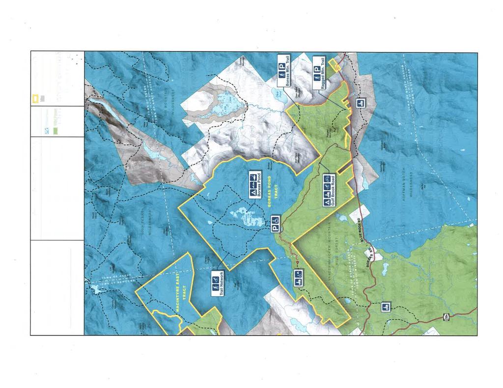
3 PROTECT calls for more Wilderness lands around Boreas Ponds PROTECT supports the DEC s proposal to classify the Boreas Ponds as Wilderness and tear down the Boreas Lodge. PROTECT supports maintaining the Gulf Brook Road to provide access to the Boreas Ponds as well as access to extensive forest lands. PROTECT believes that the Gulf Brook Road should be the border between Wild Forest and Wilderness. PROTECT would like to see the Ragged Mountain tract classified as Wilderness as well said Peter Bauer. All of the maps and materials referenced in this press release are posted on the PROTECT website ( Protect the Adirondacks Protect the Adirondacks is a privately funded, IRS-approved not-for-profit organization dedicated to the protection of the 6-million-acre Adirondack Park in northern New York. PROTECT was formed through the merger of the Association for the Protection of the Adirondacks and the Residents Committee to Protect the Adirondacks in 009. PROTECT pursues its mission through citizen advocacy, grassroots organizing, education, research, and legal action. PROTECT is guided by a volunteer Board of Directors. PROTECT maintains an office in George. For more information see ## 3
4 Proposed New 39,000 Acre Upper Hudson River Wilderness Area Locator Map EASEMENT n ow F l o w Hu dso Good n R iver CONSERVATION E ss ex Ch ain L VANDERWHACKER s ake WILD FOREST NORTH Ceda r R i v e r CLUB Hu er BLUE MOUNTAIN WOODS iv WILD FOREST R an I i nd ds on Ri v er Legend Proposed Upper Hudson River Wilderness Area Proposed Wild Forest Former Finch Land to Forest Preserve Finch Conservation Easement Conservation Easement Wild Forest Corridor North River SIAMESE PONDS WILDERNESS Primitive Corridor Town Boundary County Boundary APA Land Classification Hamlet Moderate Intensity Low Intensity Rural Use Resource Management Industrial Use Wilderness Canoe Area Primitive Wild Forest Intensive Use Historic State Administrative Pending Classification Water Miles


5
6 Recommendations for Additions to High Peaks Wilderness Area Locator Map NY 73 NY 73 Henderson Lower Ausable High Peaks Wilderness Upper Ausable Dix Mountain Wilderness Tahawus Mine Site Newcomb Elk Boreas Ponds 5 H u ds o n Gu R iv e r lf B ro ok Clear Pond Ro ad Legend Proposed High Peaks Wilderness Area Proposed Wild Forest Town Boundary County Boundary Conservation Easement H uds o n R iv er APA Land Classification Hamlet Moderate Intensity Low Intensity Rural Use Resource Management Industrial Use Wilderness Canoe Area Primitive Wild Forest Intensive Use Historic State Administrative Pending Classification Water Hu ds on Ri v er VANDERWHACKER WILD FOREST NY 8N Hoffman Notch Wilderness Miles Map production: James A. Zack, Xtra-Spatial Productions, LLC
7
Hon. Basil Seggos Acting Commissioner NYS Department of Environmental Conservation 325 Broadway Albany, NY 12233
 January 26, 2016 Board of Directors Charles Clusen Chair Sidney Harring Dale Jeffers Michael Wilson Vice-Chairs James Long Secretary David Quinn Treasurer Nancy Bernstein John Caffry Dean Cook Marilyn
Proposed Backcountry Area Definition and Guidelines
 Proposed Backcountry Area Definition and Guidelines Proposed Backcountry Area Definition and Guidelines A Backcountry Area is proposed as a section of state land where the size and quality of the landscape
January 31, Sherman Craig, Chairman NYS Adirondack Park Agency PO Box 99 Ray Brook, NY 12977
 Board of Directors Charles Clusen Chair Marilyn DuBois Sidney Harring Michael Wilson Vice-Chairs James McMartin Long Secretary David Quinn Treasurer Nancy Bernstein Richard Booth John Caffry Andy Coney
Boreas Ponds And A Bigger Adirondack High Peaks Wilderness
 Boreas Ponds And A Bigger Adirondack High Peaks Wilderness by Phil Brown Adirondack Explorer TUESDAY, JANUARY 19, 2016 The High Peaks form the backdrop of Boreas Ponds (Photo by Carl Heilman II/Courtesy
Snowmobile Connectors Are Disconnected
 Snowmobile Connectors Are Disconnected By Dave Gibson Adirondack Explorer MONDAY, AUGUST 10, 2015 The Boreas River and Route 28N where DEC proposes a new snowmobile bridge. Photo c Dave Gibson The contradictory,
Josh Clague, Natural Resources Planner NYS DEC 625 Broadway, 5th Floor Albany, NY Via
 16 June 2017 Conservation Education Recreation Since 1922 Member Services 814 Goggins Rd. Lake George, NY 12845-4117 Phone: (518) 668-4447 Fax: (518) 668-3746 e-mail: adkinfo@adk.org website: www.adk.org
On The Boreas Ponds Acquisition
 On The Boreas Ponds Acquisition by David Gibson, Adirondack Almanack SUNDAY, APRIL 17, 2016 Boreas Ponds looking towards the High Peaks Wilderness. Photo c Dave Gibson My first reaction to the announcement
16 June Conservation. Education
 16 June 2017 Conservation Education Recreation Since 1922 Member Services 814 Goggins Rd. Lake George, NY 12845-4117 Phone: (518) 668-4447 Fax: (518) 668-3746 e-mail: adkinfo@adk.org website: www.adk.org
Newsletter of Protect the Adirondacks November 2012
 Newsletter of Protect the Adirondacks www.protectadks.org November 2012 Inside: Great news with the new 69,000-acre Finch lands Forest Preserve purchase, Update on lawsuit challenging the APA on Adirondack
Deal of the century. Adirondack Nature Conservancy buys all 161,000 acres owned by Finch, Pruyn. BY PHIL BROWN EXPLORER CORRESPONDENT
 Photo by Gerry Lemmo/courtesy of the Nature Conservancy The Essex Chain of Lakes lies at the heart of the proposed Wild Rivers Wilderness. Deal of the century Adirondack Nature Conservancy buys all 161,000
S Central Coast Heritage Protection Act APRIL 21, 2016
 STATEMENT OF GLENN CASAMASSA ASSOCIATE DEPUTY CHIEF, NATIONAL FOREST SYSTEM U.S. FOREST SERVICE U.S. DEPARTMENT OF AGRICULTURE BEFORE THE UNITED STATES SENATE COMMITTEE ON ENERGY AND NATURAL RESOURCES
April 10, Mark Stiles San Juan Public Lands Center Manager 15 Burnett Court Durango, CO Dear Mark,
 Mark Stiles San Juan Public Lands Center Manager 15 Burnett Court Durango, CO 81301 Dear Mark, We are pleased to offer the following comments on the draft San Juan Public Lands Center management plans
June 14, Conservation. Education
 June 14, 2017 Conservation Education Recreation Since 1922 Member Services 814 Goggins Rd. Lake George, NY 12845-4117 Phone: (518) 668-4447 Fax: (518) 668-3746 e-mail: adkinfo@adk.org website: www.adk.org
Rogue River Access and Management Plan Draft Alternatives
 Rogue River Access and Management Plan Draft Alternatives The Rogue River Access and Management Plan was initiated in December, 2011 and is being led by Jackson County Parks (JCP) and Oregon Department
Acting Commissioner Basil Seggos NYS Department of Environmental Conservation 625 Broadway, 14th Floor Albany, NY 12233
 Board of Directors Charles Clusen Chair Sidney Harring Dale Jeffers Michael Wilson Vice-Chairs James Long Secretary David Quinn Treasurer Joshua Axelrod Nancy Bernstein John Caffry Dean Cook Marilyn DuBois
Where the Wild Is. Mapping. the Full Wilderness Potential of the Adirondack Forest Preserve. Bill Ingersoll
 Where the Wild Is Mapping the Full Wilderness Potential of the Adirondack Forest Preserve Bill Ingersoll Get Out. Seek Out. FIND OUT. www.hiketheadirondacks.com Published March 2015 WILD RIVER Press 7123
LOCAL PLAN FOR THE MANAGEMENT OF THE APPALACHIAN TRAIL IN MAINE. (GRAFTON NOTCH TO KATAHDIN) 1 January 2013 (Revised 5 February 2014)
 1 January 2013 (Revised 5 February 2014)") LOCAL PLAN FOR THE MANAGEMENT OF THE APPALACHIAN TRAIL IN MAINE (GRAFTON NOTCH TO KATAHDIN) 1 January 2013 (Revised 5 February 2014) The Appalachian Trail is a way, continuous from Katahdin in Maine to
LOCAL PLAN FOR THE MANAGEMENT OF THE APPALACHIAN TRAIL IN MAINE (GRAFTON NOTCH TO KATAHDIN) 1 January 2013 (Revised 5 February 2014) The Appalachian Trail is a way, continuous from Katahdin in Maine to
APPENDIX OFFICIAL MAP ORDINANCE OF HAMILTONBAN TOWNSHIP OFFICIAL MAP NARRATIVE
 APPENDIX A OFFICIAL MAP ORDINANCE OF HAMILTONBAN TOWNSHIP OFFICIAL MAP NARRATIVE INTRODUCTION: The Official Map of Hamiltonban Township has been prepared to identify those lands and features that Hamiltonban
I. PREFACE II. THE PARTNERSHIP
 I. PREFACE This document is the "local" plan for the management of the Appalachian Trail in Maine from Maine Highway 26 in Grafton Notch to the summit of Katahdin. It is a part (the other being the Appalachian
FAQ: HR 799 & S. 403: North Country National Scenic Trail Route Adjustment Act
 FAQ: HR 799 & S. 403: North Country National Scenic Trail Route Adjustment Act Exactly what does HR 799/S. 403 call for? These bills simply amend the National Trails System Act (16 U.S.C. 1244(a)(8)) by:
April Counties of Franklin, Hamilton and St. Lawrence. Division of Lands & Forests
 Division of Lands & Forests Bog River Complex Final AMENDMENT/FSEIS to the 2002 Bog River Complex Unit Management Plan/EIS Horseshoe Lake Wild Forest Hitchins Pond Primitive Area Lows Lake Primitive Area
Peter Henderson. Session 3
 Peter Henderson Session 3 1 The Great Adirondack Camps The Gilded Age 2 Great camp built by Brazil ambassador to the United States in early 1900 s Keene Valley 3 Camp Pine Knot - William West Durant. Begun
Map 1.1 Wenatchee Watershed Land Ownership
 Map 1.1 Wenatchee Watershed Land Ownership Map 1.1 Wenatchee Watershed Land Ownership The Wenatchee watershed lies in the heart of Washington state in Chelan County. Just larger than the state of Rhode
Table 3-7: Recreation opportunity spectrum class range by prescription. Recreation Opportunity Spectrum (ROS) Classes
 Classes") Appendix F Table -7: Recreation opportunity spectrum class range by prescription. Recreation Opportunity Spectrum (ROS) Classes Prescription Primitive Primitive II Roaded Modified Rural Urban 111 - Primitive
Appendix F Table -7: Recreation opportunity spectrum class range by prescription. Recreation Opportunity Spectrum (ROS) Classes Prescription Primitive Primitive II Roaded Modified Rural Urban 111 - Primitive
Proposed Scotchman Peaks Wilderness Act 2016 (S.3531)
") 1 Proposed Scotchman Peaks Wilderness Act 2016 (S.3531) Frequently Asked Questions PLACE Where is the area that would be designated as Wilderness? The lands outlined in S.3531 lie within Idaho along its
1 Proposed Scotchman Peaks Wilderness Act 2016 (S.3531) Frequently Asked Questions PLACE Where is the area that would be designated as Wilderness? The lands outlined in S.3531 lie within Idaho along its
Southeastern Adirondack Forest Preserve Visitor Study
 Southeastern Adirondack Forest Preserve Visitor Study Chad P. Dawson, Jennifer Baker, Lindsey Barker, and Corey Williams SUNY College of Environmental Science and Forestry 320 Bray Hall One Forestry Drive
Open Space Index. Town of Philipstown. Adopted January 8, Submitted by: Philipstown Conservation Advisory Committee
 Open Space Index Town of Philipstown Adopted January 8, 2009 Submitted by: Philipstown Conservation Advisory Committee Acting Chair Eric Lind Mark Galezo Andy Galler Lew Kingsley Mike Leonard MJ Martin
Crew Chief: Start Date: Completion Date: T & A Code:
 Completed Work Data Work order # Crew Chief: Start Date: Completion Date: T & A Code: Work Complete Comments: Personnel Service: Equipment: Item ID# Hours/Miles Rental Cost Supplies & Materials: Item Invoice#
(Short Listing) DUPUYER ACREAGE, ROCKY MOUNTAN FRONT
 DUPUYER ACREAGE, ROCKY MOUNTAN FRONT") (Short Listing) DUPUYER ACREAGE, ROCKY MOUNTAN FRONT This unique property is located 8½ miles northwest of Dupuyer, Montana and approximately thirty 30 miles northwest of Choteau, Montana. Great Falls
(Short Listing) DUPUYER ACREAGE, ROCKY MOUNTAN FRONT This unique property is located 8½ miles northwest of Dupuyer, Montana and approximately thirty 30 miles northwest of Choteau, Montana. Great Falls
Clearwater Lake Provincial Park. Draft Management Plan
 Clearwater Lake Provincial Park Draft Management Plan Clearwater Lake Provincial Park Draft Management Plan Table of Contents 1. Introduction... 3 2. Park History... 4 3. Park Attributes... 4 3.1 Location/Access...4
Recreation Opportunity Spectrum for River Management v
 Recreation Opportunity Spectrum for Management v. 120803 Introduction The following Recreation Opportunity Spectrum (ROS) characterizations and matrices mirror the presentation in the ROS Primer and Field
Segment 2: La Crescent to Miller s Corner
 goal of the USFWS refuges is to conserve, protect and enhance fish, wildlife and plants and their habitats for the continuing benefit of the American people. Refuge lands are used largely for fishing,
2/7/2012. Mission Mountains Wilderness Contracting as a management alternative Climb the mountains and get their good tidings John Muir
 Wilderness Contracting as a management alternative Climb the mountains and get their good tidings John Muir Kari Gunderson Wilderness Education and Management Specialist Swan Valley, Montana In memory
Continental Divide National Scenic Trail Legislative History and Planning Guidance
 Continental Divide National Scenic Trail Legislative History and Planning Guidance Legislation, Policy, and Direction Regarding National Scenic Trails The National Trails System Act, P.L. 90-543, was passed
Join us in preserving a community treasure
 C u n n i n g h a m Po n d Pe t e r b o ro u g h, N H Join us in preserving a community treasure Cunningham Pond is one of the places people love most in Peterborough. Protecting it today will ensure it
May 2, Kathleen D. Regan Deputy Director, Planning Adirondack Park Agency P.O. Box State Route 86 Ray Brook, NY 12977
 May 2, 2018 Kathleen D. Regan Deputy Director, Planning Adirondack Park Agency P.O. Box 99 1133 State Route 86 Ray Brook, NY 12977 RE: Amendments to the Adirondack Park State Land Master Plan (APSLMP)
State-designated Wilderness in the United States: ANational Review
 STEWARDSHIP State-designated Wilderness in the United States: ANational Review BY BLAKE M. PROPST and CHAD P. DAWSON Introduction In recent decades, the word wilderness has been used to designate, define,
2. Goals and Policies. The following are the adopted Parks and Trails Goals for Stillwater Township:
 D. PARKS AND TRAILS 1. Introduction Stillwater Township s population is relatively low, with most residents living on rural residences on large lots. The need for active park space has been minimal in
Appalachian Mountain Club
 Appalachian Mountain Club January 30, 2013 Groton Planning Board 754 North Groton Road Groton, NH 03241 Re: Re-opened public hearing regarding a request by EDP Renewables (Lessee), EXPX2/MAXAM (Owner)
Proposal to Redevelop Lower Kananaskis River-Barrier Lake. Bow Valley Provincial Park. Frequently Asked Questions
 Proposal to Redevelop Lower Kananaskis River-Barrier Lake Bow Valley Provincial Park Frequently Asked Questions What is being proposed? What are the details of the proposal? Where is the project area located?
Dear Reviewing Officer:
 From: To: Subject: Date: Attachments: Peter Hart FS-r02admin-review Objection Re: Maroon Bells Snowmass Wilderness Overnight Visitor Use Management Plan Monday, August 14, 2017 8:38:01 PM Final Objection
Coast to Coast Connector Summit
 Project Partners Welcome to the Coast to Coast Connector Summit Winter Garden, Florida City Hall October 1, 2014 1 Why are we here? Objectives 1. Inform key stakeholders on the current state of the C2C
OMINEACA PROVINCIAL PARK
 OMINEACA PROVINCIAL PARK AND PROTECTED AREA PURPOSE STATEMENT AND ZONING PLAN March 2003 OMINECA PROVINCIAL PARK AND PROTECTED AREA Purpose Statement and Zoning Plan Omineca Park and Omineca Protected
9 December 2016 Maxwell Wolckenhauer NYS DEC State Highway 10, Suite 1 Stamford, NY Conservation.
 Conservation Education Recreation Since 1922 9 December 2016 Maxwell Wolckenhauer NYS DEC 65561 State Highway 10, Suite 1 Stamford, NY 12167 r4.ump@dec.ny.gov RE: Windham-Blackhead Range Wilderness UMP
Mapping our ADK Future where are we now? Dave Mason and Jim Herman July 18, 2013 Common Ground Alliance Forum
 Mapping our ADK Future where are we now? Dave Mason and Jim Herman July 18, 2013 Common Ground Alliance Forum How We ve Spent the Last Year Workshops with various ADK groups WCS Advisory, ROOST, AATV,
MANAGEMENT DIRECTION STATEMENT June, 1999
 Thompson River District MANAGEMENT DIRECTION STATEMENT June, 1999 for Clearwater River Corridor (Addition to Wells Gray Park) Ministry of Environment Lands and Parks BC Parks Division ii Table of Contents
Plaintiff-Petitioner. Defendants-Respondents.
 STATE OF NEW YORK SUPREME COURT COUNTY OF ALBANY In the Matter of the Application of PROTECT THE ADIRONDACKS! INC., AFFIDAVIT OF JOSHUA D. CLAGUE Plaintiff-Petitioner For a Judgment Pursuant to Section
HEATHER-DINA LAKES PROVINCIAL PARK
 HEATHER-DINA LAKES PROVINCIAL PARK PURPOSE STATEMENT AND ZONING PLAN March 2003 HEATHER-DINA LAKES PROVINCIAL PARK Purpose Statement and Zoning Plan Heather-Dina Lakes Provincial Park is located 25 km
Establishing a National Urban Park in the Rouge Valley
 STAFF REPORT ACTION REQUIRED Establishing a National Urban Park in the Rouge Valley Date: March 29, 2012 To: From: Wards: Reference Number: Executive Committee Deputy City Manager, Cluster B All p:\2012\cluster
Welcome to Natural Bridge
 Welcome to Natural Bridge Richard R. Randolph IV www.r4capital.com Www.r4land.com 205-879-5517 Work 205-413-8805 Fax 6 Carla Circle Birmingham, AL 35213 rich@r4capital.com Introduction NATURAL BRIDGE 160
2009 Clearwater Area Sheep
 2009 Clearwater Area Sheep Section Authors: Chiarastella Feder and Shevenell Webb Suggested Citation: Feder, C. and S. Webb. 2009. Clearwater Area Sheep. Pages 22 25. In: N. Webb and R. Anderson. Delegated
Final Environmental Impact Statement for the Merced Wild and Scenic River. Comprehensive Management Plan, Yosemite National Park, Madera and Mariposa
 This document is scheduled to be published in the Federal Register on 02/26/2014 and available online at http://federalregister.gov/a/2014-04061, and on FDsys.gov DEPARTMENT OF THE INTERIOR 4312-FF NATIONAL
MANAGEMENT DIRECTION STATEMENT June, 1999
 Thompson River District MANAGEMENT DIRECTION STATEMENT June, 1999 for Roche Lake Provincial Park Ministry of Environment Lands and Parks BC Parks Division Table of Contents I. Introduction A. Setting
PAD-US 1.1 (CBI Edition) Management Designations. National Parks (NPS) and National Park
 Management Designations. National Parks (NPS) and National Park") Noise Sensitive Areas Avoidance Criteria & Source PAD-US 1.1 (CBI Edition) Management Designations Falcon View "DESGINATE" Field Terminology Falcon View Display Category Boundary Waters Canoe Wilderness
Noise Sensitive Areas Avoidance Criteria & Source PAD-US 1.1 (CBI Edition) Management Designations Falcon View "DESGINATE" Field Terminology Falcon View Display Category Boundary Waters Canoe Wilderness
Chester Townwide Recreation Plan Meeting Summary for July 30, 2014 Public Open House
 Chester Townwide Recreation Plan Meeting Summary for July 30, 2014 Public Open House Submitted By: Tracey M. Clothier Introductions: Supervisor Monroe introduced Committee Members and Consultants. Meeting
Hermosa Area Preservation The Colorado Trail Foundation 4/11/2008
 Hermosa Area Preservation The Colorado Trail Foundation 4/11/2008 Legend d o Tr ail NPA - National Protection Area ra NCA - National Conservation Area o e C Th The Colorado Trail lo FS inventoried Roadless
New York State Buys Essex Chain of Lakes for Preserve Wild Rivers Wilderness Soon Possible INSIDE
 Winter 2013 Defending the East s Greatest Wilderness N ews in and about the six- million - acre A dirondack Park New York State Buys Essex Chain of Lakes for Preserve Wild Rivers Wilderness Soon Possible
Annual Report 2017 L ATE 2017 N EWS S AVING L AND - M AKING T RAILS G OOD N EWS FOR Immediate action needed CATS acts!
 Annual Report 2017 L ATE 2017 N EWS Immediate action needed CATS acts! S AVING L AND - M AKING T RAILS CATS saves Viall s Crossing A historic farm in Westport Critical link in Split Rock Wildway Secures
The Recreational Trail along Cushing Park road has been a successful addition to the city
 The Recreational Trail along Cushing Park road has been a successful addition to the city Trails TRAILS, PATHS, ROUTES AND CONNECTORS Citizen input pointed to trails, paths, bike routes, and other non-motorized
Blue Trails: Protecting Rivers, Fostering Stewardship
 Blue Trails: Protecting Rivers, Fostering Stewardship What Are Blue Trails? Blue Trails are the water equivalent of hiking trails. They are created to facilitate recreation in and along rivers and water
Trails. Lois Jensen Nature Preserve is a 30 acre parcel on the north end of the city. It provides unspoiled wooded paths.
 Trails Lois Jensen Nature Preserve is a 30 acre parcel on the north end of the city. It provides unspoiled wooded paths. TRAIL S, PATHS, ROUTES AND CONNECTORS Citizen input pointed to trails, paths, bike
The Chu property is a 6.57 acre parcel located in the Town of Superior on the west side of McCaslin Boulevard. In 2014, the Town of Superior acquired
 1 The Chu property is a 6.57 acre parcel located in the Town of Superior on the west side of McCaslin Boulevard. In 2014, the Town of Superior acquired the Chu property for open space with a contribution
Crew Chief: Start Date: Completion Date: T & A Code:
 Completed Work Data Work order # Crew Chief: Start Date: Completion Date: T & A Code: Work Complete Comments: Personnel Service: Equipment: Item ID# Hours/Miles Rental Cost Supplies & Materials: Item Invoice#
RUSHMORE CONNECTOR TRAIL PROPOSAL
 PURPOSE AND NEED Background The U.S. Forest Service, Black Hills National Forest (Forest Service) has received a special use permit application from the State of South Dakota Department of Game, Fish and
Chattahoochee- Oconee National Forests. Decision Memo
 Page 1 of 6 USDA Forest Service Chattahoochee- Oconee National Forests Decision Memo Chattahoochee-Oconee National Forests Home Page Recreation Information Forest History Forest Facts Forest Management
National Park Service Wilderness Action Plan
 National Park Service U.S. Department of the Interior National Park Service Wilderness Action Plan National Wilderness Steering Committee National Park Service "The mountains can be reached in all seasons.
THOMAS A. SWIFT METROPARK Introductions History Present Conditions Future Development Plans Implementation Strategies Statistics
 THOMAS A. SWIFT METROPARK Introductions History Present Conditions Future Development Plans Implementation Strategies Statistics Introduction As an open meadow park positioned along the Mahoning River,
H. R IN THE HOUSE OF REPRESENTATIVES
 I 113TH CONGRESS 1ST SESSION H. R. 1776 To establish the Clear Creek National Recreation Area in San Benito and Fresno Counties, to designate the Joaquin Rocks Wilderness in such counties, to designate
Introducing the Lower Connecticut River Valley Trail
 Introducing the Lower Connecticut River Valley Trail 1 2 Purpose of Today s Presentation To introduce you to an important opportunity to protect some of the most valuable property in the Lower CT River
Birch Point Provincial Park. Management Plan
 Birch Point Provincial Park Management Plan 2 Birch Point Provincial Park Table of Contents 1. Introduction... 3 2. Park History... 3 3. Park Attributes... 4 3.1 Natural... 4 3.2 Recreational... 4 4. Park
Numaykoos Lake Provincial Park. Management Plan
 Numaykoos Lake Provincial Park Management Plan 2 Numaykoos Lake Provincial Park Table of Contents 1. Introduction... 3 2. Background... 3 3. Park Purpose... 5 4. Park Management Guidelines... 6 Appendix...
Preferred Recreation Recommendations Stemilt-Squilchuck Recreation Plan March 2018
 Preferred Recreation Recommendations Stemilt-Squilchuck Recreation Plan March 2018 Below are the recommended recreation ideas and strategies that package together the various recreation concepts compiled
Classification and Management Planning (CAMP) Washington State Parks and Recreation Commission
 Washington State Parks and Recreation Commission") Classification and Management Planning (CAMP) Tonight s agenda Welcome, sign-in, handouts Staff introductions Planning area and park overview Description of planning process Get your input Next steps Adjourn
Classification and Management Planning (CAMP) Tonight s agenda Welcome, sign-in, handouts Staff introductions Planning area and park overview Description of planning process Get your input Next steps Adjourn
Schoolcraft Township is located in northeast Houghton County. A portion of the township borders Keweenaw County and Lake Superior.
 COMMUNITY DESCRIPTION Schoolcraft Township is located in northeast Houghton County. A portion of the township borders Keweenaw County and Lake Superior. The township is largely rural but has one main population
Mountain Biking and Off Road Trails in Warren County, New York
 Mountain Biking and Off Road Trails in Warren County, New York Warren County Safe and Quality Bicycling Organization 96 Country Club Road Queensbury, NY 12804 www.bikewarrenco.org Warren County Safe and
EMERY COUNTY PUBLIC LAND MANAGEMENT ACT OF 2018 S. 2809/H.R. 5727
 EMERY COUNTY PUBLIC LAND MANAGEMENT ACT OF 2018 S. 2809/H.R. 5727 September 25, 2018 OVERVIEW The Emery County Public Land Management Act of 2018 is a significant step backwards for wilderness and conservation
BUCK POINT RANCH. Aspen Associates Realty
 BUCK POINT RANCH Aspen Associates Realty www.aspenassociatesrealty.com 970.544.5800 WELCOME TO Buck Point Ranch is a 960± acre property located in one of the last pristine valleys in close proximity to
BeWildNY sounds off on their plan for Boreas Pond
 BeWildNY sounds off on their plan for Boreas Pond Sun Community News December 15, 2016 http://www.suncommunitynews.com/articles/the-sun/bewildny-sounds-off-on-their-plan-forboreas-pond/ The state purchased
TAYLOR CANYON RANCH COLORADO - ROUTT COUNTY - STEAMBOAT SPRINGS
 TAYLOR CANYON RANCH COLORADO - ROUTT COUNTY - STEAMBOAT SPRINGS Tucked up against the steep valley shaped by Mt. Pau and rising to the Routt National Forest, Taylor Canyon Ranch is an easily accessible,
This document is being shared by the Parks, Recreation and Musuem Advisory Board at the request of Golden citizens and in order to be transparent
 This document is being shared by the Parks, Recreation and Musuem Advisory Board at the request of Golden citizens and in order to be transparent about what documents and information was shared during
Submission on the Tukituki Catchment Proposal: EPA reference numbers; NSP 13/ , NSP 13/ , NSP 13/ , NSP 13/02.
 Hutt Valley Tramping Club PO Box 30 883 LOWER HUTT 5045 Tukituki Catchment Proposal Environmental Protection Agency Private Bag 63 002 WELLINGTON 6140 29 July 2013 Submission on the Tukituki Catchment
Inholdings within Wilderness: Legal Foundations, Problems, and Solutions
 In the western United States, land inholdings in wilderness are largely a result of five legislative acts: the 1872 Mining Law (17 Stat. 91), the 1862 Homestead Act (12 Stat. 392), the 1864 and 1870 Land
U.S. Forest Service National Minimum Protocol for Monitoring Outstanding Opportunities for Solitude
 U.S. Forest Service National Minimum Protocol for Monitoring Outstanding Opportunities for Solitude Element 5 of the 10-Year Wilderness Stewardship Challenge May 15, 2014 1 Solitude Minimum Protocol Version
Dumont Dunes Special Recreation Management Area (SRMA)
") Dumont Dunes Special Recreation Management Area (SRMA) RMA/RECREATION MANAGEMENT ZONE (RMZ) OBJECTIVE(S) DECISIONS Objective Statement: Designate this area as a Special Recreation Management Area. To manage
Dumont Dunes Special Recreation Management Area (SRMA) RMA/RECREATION MANAGEMENT ZONE (RMZ) OBJECTIVE(S) DECISIONS Objective Statement: Designate this area as a Special Recreation Management Area. To manage
Strategic Plan. Manassas Battlefield Trust
 Manassas Battlefield Trust m Strategic Plan 2018-2020 M a n a s s a s B a t t l e f i e l d T r u s t, 1 2 5 2 1 L e e H i g h w a y, M a n a s s a s, V A 2 0 1 0 9 Manassas Battlefield Trust Manassas,
S. 37, Forest Jobs and Recreation Act (FJRA)
") Testimony of Jeremy Fancher, International Mountain Bicycling Association Before the U.S. Senate Committee on Energy and Natural Resources Subcommittee on Public Lands, Forests, and Mining Hearing on Misc.
Testimony of Jeremy Fancher, International Mountain Bicycling Association Before the U.S. Senate Committee on Energy and Natural Resources Subcommittee on Public Lands, Forests, and Mining Hearing on Misc.
CONTRIBUTOR REWARDS PROGRAM
 CONTRIBUTOR REWARDS PROGRAM Here s how it works... Document + submit an adventure Earn Adventure Points (AP) when it s published Get rewards: awards, prizes, pro deals + earn cash Page Document + submit
THE SETTING REGION COMMUNITY ANALYSIS
 THE SETTING REGION COMMUNITY ANALYSIS REGION Historical Setting The Crane Lake waterway pre-dates the American Indians who traveled its waters for generations before it became a fur-trading route for the
A CASE FOR COMPLETING THE JORDAN RIVER PARKWAY: A
 A CASE FOR COMPLETING THE JORDAN RIVER PARKWAY: A safe crossing at 9000 South and 850 West Proposed 9000 South Underpass Parkway Timeline Parkway, Trail, and Tourism Facts Blueprint Jordan River 1971 1973
Environment and Natural Resources Trust Fund 2019 Request for Proposals (RFP)
") Environment and Natural Resources Trust Fund 2019 Request for Proposals (RFP) Project Title: Glacial Edge Trail and Downtown Pedestrian Bridge Category: G. Land Acquisition for Habitat and Recreation ENRTF
Environment and Natural Resources Trust Fund 2019 Request for Proposals (RFP) Project Title: Glacial Edge Trail and Downtown Pedestrian Bridge Category: G. Land Acquisition for Habitat and Recreation ENRTF
Sasagiu Rapids Provincial Park. Draft Management Plan
 Sasagiu Rapids Provincial Park Draft Management Plan 2 Sasagiu Rapids Provincial Park Table of Contents 1. Introduction... 3 2. Background and Park Attributes... 3 2.1 Park History.... 3 2.2 Natural Features...
Wallace Lake Provincial Park. Draft Management Plan
 Wallace Lake Provincial Park Draft Management Plan Wallace Lake Provincial Park Draft Management Plan Table of Contents 1. Introduction... 3 2. Park History... 3 3. Park Attributes... 4 3.1 Natural...
Appalachian Mountain Club
 Appalachian Mountain Club June 3, 2013 Town of Alexandria Board of Selectmen 47 Washburn Road Alexandria, NH 03222 Re: Appalachian Mountain Club s comments on EDP Renewables building permit application
LAND USE GUIDELINES NEW TOWN
 VI LAND USE A L T ETruRck TNraiAl T I V E S AarNnelDla D E S I G N W GUIDELINES NEW TOWN ad Ro DAVEN CA LF IRE ALTERNATIVE LAND USE PLANS AND DESIGN GUIDELINES - VI VI LAND USE ALTERNATIVES Asilomar Hotel
CITY OF HUDSON COUNCIL/COMMITTEE ISSUES
 Item # 8 Submitted to: Public Safety Committee Date: 04/11/2017 Submitted by: Chief Marty Jensen Regarding: CITY OF HUDSON COUNCIL/COMMITTEE ISSUES Backcountry Brewfest ISSUE: Attached to this issue sheet
Pinellas County Environmental Lands
 Pinellas County Environmental Lands In addition to traditional parks and recreation facilities, Pinellas County owns and manages a system of environmental lands that provides specialized resource-based
Village of Taos Ski Valley 2015 Master Plan. Recreation Element
 Village of Taos Ski Valley 2015 Master Plan Taos Ski Valley is known across the world for skiing and winter sports, but the Village has more to offer than advanced skiing terrain and short lift lines.
375 Sheldon Road, Fair Haven, VT
 375 Sheldon Road, Fair Haven, VT Curtis Trousdale, Owner, Broker, Realtor Cell: 802-233-5589 curtis@preferredpropertiesvt.com 2004 Williston Road, South Burlington VT 05403 www.preferredpropertiesvt.com
Wallace Lake Provincial Park. Management Plan
 Wallace Lake Provincial Park Management Plan 2 Wallace Lake Provincial Park Table of Contents 1. Introduction... 3 2. Park History... 3 3. Park Attributes... 4 3.1 Natural... 4 3.2 Recreational... 4 4.
Oregon Equestrian Trails Mt. Hood Chapter
 Oregon Equestrian Trails Mt. Hood Chapter November 17, 2010 To: Michelle Lombardo, Mt. Hood National Forest From: Barb Adams, Oregon Equestrian Trail, Mt. Hood Chapter Re: Barlow and Hood River Ranger