St. Croix River Crossing Project Memorandum of Understanding For the Implementation of Riverway Mitigation Items
|
|
|
- Cleopatra Rogers
- 5 years ago
- Views:
Transcription
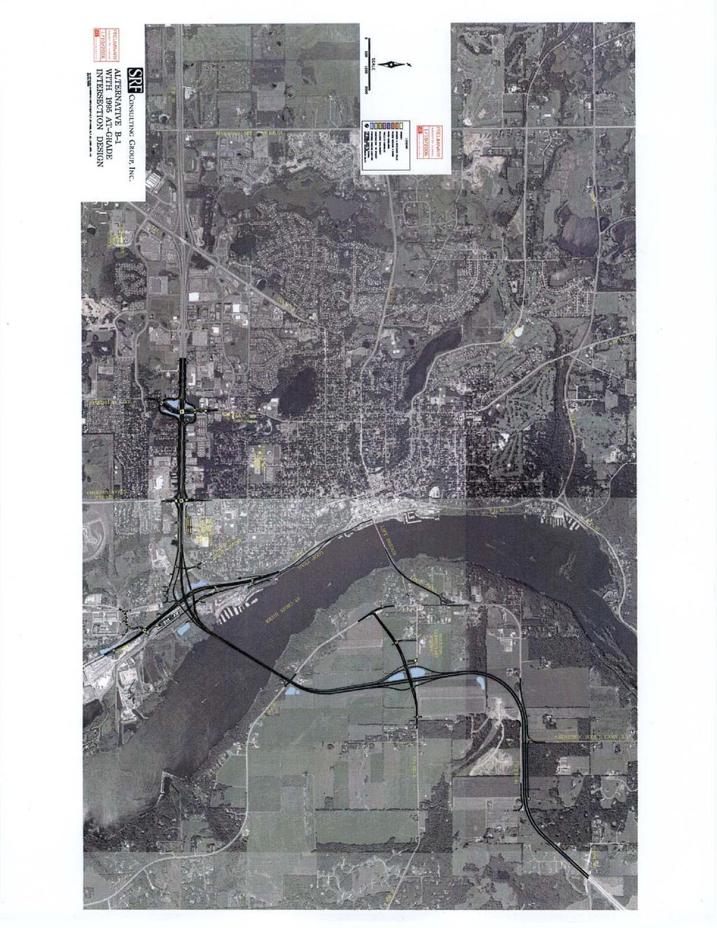
1 St. Croix River Crossing Project Memorandum of Understanding For the Implementation of Riverway Mitigation Items Between the National Park Service, The Minnesota Department of Natural Resources, The Wisconsin Department of Natural Resources, The Federal Highway Administration, The Minnesota Department of Transportation And the Wisconsin Department of Transportation 1. The Federal Highway Administration (FHWA), the Minnesota Department of Transportation (Mn/DOT) and Wisconsin Department of Transportation (WisDOT) plan to construct a new crossing of the St. Croix River between the City of Oak Park Heights in Washington County, Minnesota and the Town of St. Joseph, in St. Croix County, Wisconsin, including construction in the cities of Stillwater and Bayport, as described in the 2006 Supplemental Final Environmental Impact Statement (SFEIS) for the St. Croix River Crossing Project; and 2. The impacts of the Project are described and discussed in Chapters 4 through 14 of the SFEIS. Riverway impacts are being avoided and minimized to the extent possible. Chapter 15 documents the adverse environmental impacts of the Preferred Alternative that cannot be avoided on the Lower St. Croix National Scenic Riverway and the mitigation package; and 3. The National Park Service draft 7(a) evaluation indicates that with appropriate mitigation, the Preferred Alternative would not have a direct and adverse effect on the scenic and recreational values for which the Lower St. Croix Riverway was included in the national Wild and Scenic Rivers System; and 4. Table 15-2 of the SFEIS provides a summary overview of the Preferred Alternative mitigation package and includes: mitigation dollar amounts to be provided by the transportation agencies; the agency or agencies responsible for implementation of the mitigation item; the schedule for implementation; and the contract or agreement necessary for execution of the mitigation item; and 5. For Mitigation Items 9b., f., g., i., and k. of this Memorandum of Understanding (MOU), the parties will negotiate and enter into specific agreements, in accordance with applicable laws, to outline the financial arrangements and administrative details to carry out the intentions expressed in this MOU. 6. For Mitigation Item 9b. only, for administrative efficiency, the source of all funds to be provided to the Wisconsin Department Natural Resources (WisDNR) and to St. Croix County, and distributed to the Town of St. Joseph will be from Mn/DOT Project appropriations. 1
2 7. An implementation graphic describing the Mitigation for Riverway Impacts is attached which also provides the additional implementation details for each of the items; and 8. The above agencies wish to enter into this MOU to further refine the implementation of each mitigation item; and 9. Mitigation Items: The following is further refinement of each of the Riverway Impacts mitigation items. a. Removal of Xcel Barge Unloader Facility and Mooring Cells: Mn/DOT will remove the barge unloading facility and mooring cells associated with the Xcel Energy King Plant from the St. Croix River, eliminating an existing man-made structure from the Riverway. The estimated cost of this mitigation item is $1.1 million. Xcel Energy owns this facility. This mitigation item is to offset the visual impacts of a new river crossing by removing an existing man-made structure from the Riverway. The facility consists of 18 mooring cells and four additional foundation cells that support a large coal barge off-loading facility that is no longer used. A conveyor system between the structure and the shoreline will also be removed. Steel sheeting from each of the mooring cells will be removed by either pulling the sheeting or cutting it off near the river bottom. The stone fill in each cell will be spread out near the cell location and would be left in-place as aquatic habitat. One pivot cell from the barge off-loading facility will remain. Any work in the river below elevation will need to be reviewed by the U. S. Army Corps of Engineers pursuant to applicable regulations and permit requirements under Section 10 of the Rivers and Harbors Act and Section 404 of the Clean Water Act. Mn/DOT has also proposed to use the Xcel barge unloading facility and mooring cells as a barge docking facility during the Preferred Alternative river crossing construction. Temporary barge docking facilities will be placed in the river for use during construction of the Preferred Alternative. Reuse of the existing Xcel facility during river crossing construction will result in one fewer temporary barge docking facility that will need to be constructed. This property has been evaluated as not eligible for listing in the National Register of Historic Places. MnSHPO concurs with this evaluation. A Memorandum of Understanding (see attachment.) has been developed between Mn/DOT and Xcel Energy regarding the use of these facilities during river crossing construction and removal following construction of the river crossing. The St. Croix River is known to contain a large and diverse fresh water mussel community, including two federally listed endangered species (Higgins eye pearly mussel and winged mapleleaf). In addition, the Xcel barge unloading facility supports an active osprey (Minnesota listed species of special concern and Wisconsin listed threatened species) nesting platform. Prior to implementation, Mn/DOT shall also evaluate, in consultation with US Fish and Wildlife Service and Minnesota Department of Natural Resources, this mitigation item for potential mussel and osprey impacts and suitable protection measures. 1. Relocation and replacement of the osprey nest requires a permit from the Minnesota Department of Natural Resources. 2
3 2. The mooring cells gravel contents will be spread on the river bottom at an elevation which will allow potential barge access to the Pivot Cell from the downstream side. The gravel contents of the cells upstream from the Pivot Cell will remain at an elevation that will allow recreational boat traffic to safely pass. b. Mitigation for damages to blufflands: As part of the Project, Mn/DOT will provide funding in the amount of $2.0 million to WisDNR and in the amount of $2.5 million to St. Croix County for the protection of replacement lands to offset the impacts of a new crossing on the Wisconsin bluff. Protection could include the purchase of fee title, the purchase or transfer of development rights or the purchase of conservation easements from willing sellers of land located in St. Croix County, Wisconsin. Protected lands would be perpetually maintained for land and water conservation purposes, scenic protection and other compatible uses, including low-impact public recreation. It is the intent of all parties to this agreement that WisDNR will use the $2 million for its own land protection efforts within the Riverway Basin. It is also the intent of all parties to this agreement that St. Croix County will use $2 million for land protection efforts within the Riverway Basin that are of benefit to the Riverway and that St. Croix County will pay the remaining $500,000 to the Town of St. Joseph for similar use. Prior to expending such funds for the protection of specific land parcels, St. Croix County and the Town of St. Joseph will consult with, and seek concurrence from, WisDNR on the targeted land parcel(s) and the proposed management of such land by St. Croix County or the Town of St. Joseph. All parties to this MOU recognize that the source of these mitigation funds is Mn/DOT Project appropriations and, therefore, St. Croix County and the Town of St. Joseph are eligible to use their respective portions to compete for matching Wisconsin Stewardship Local Assistance Grants administered by WisDNR. If St. Croix County or the Town of St. Joseph decide to partner with a non-profit conservation organization in purchasing land rights as described above, the partnering parties would be eligible to compete for other Stewardship match programs for which the local units of government themselves are not eligible. It is the recommendation of all parties of this MOU that St. Croix County and the Town of St. Joseph select projects that would be eligible for matching Wisconsin Stewardship funds in order to maximize the use of the funds provided under this paragraph. All such grant requests will be subject to WisDNR s standard, independent review process governing the Stewardship Program. As stipulated in the Section 106 Amended MOA (Stipulation VIII), for any property purchased or protected under this mitigation item, WisDNR, St. Croix County and the Town of St. Joseph shall consult with the Wisconsin State Historic Preservation Officer (WisSHPO), the Minnesota State Historic Preservation Officer (MnSHPO) and other consulting parties, including Indian tribes, as appropriate, in accordance with 36 CFR to determine if historic properties in addition to those identified in Stipulation II.C.4 of the Section 106 MOA for this project will be affected. In addition, the WisDNR, St. Croix County and the Town of St. Joseph will confer with the WisSHPO on possible sites to acquire in order to provide protection for historic properties in conjunction with land and water conservation goals. 3
4 c. Bluffland Restoration: The intent of the bluffland restoration mitigation item is to further offset the impacts of the Preferred Alternative on the Wisconsin bluff. Mitigation items include: 1. Removal of the Buckhorn sign. The Buckhorn sign is located approximately 1,800 feet north of the Preferred Alternative river crossing location along the Wisconsin bluff. Under this mitigation item, WisDOT will remove the sign and the bluff will be allowed to return to a natural state. The attached Memorandum of Understanding developed between WisDOT and the property owner, Edward T. Johnston, includes provisions for its removal. 2. Partial restoration of the Wisconsin approach to the Lift Bridge. Under this mitigation item, WisDOT will remove and restore the existing STH 64 roadway between the Lift Bridge and STH 35. WisDOT will redevelop a portion of STH 64 as a Loop Trail as described in the Visual Quality Manual for this project. WisDOT will remove the existing CTH E roadway between the CTH E/STH 64 intersection and State Street. WisDOT will revegetate the road rights-of-way with native species following removal of the pavements. d. Removal of Terra Terminal Building: The Terra Terminal building has been evaluated as not eligible for listing in the National Register of Historic Places. MnSHPO concurs with this evaluation. However, the Terra Terminal site is adjacent to the National Register-eligible Hersey Bean Saw Mill and Planing Mill archaeological sites. Mn/DOT will coordinate any activities planned for this area with the Mn/DOT Cultural Resources Unit and the MnSHPO. Refer to Chapter 11 and the Section 106 MOA in Appendix G of the SFEIS for additional detail on the Hersey Bean sites. Mn/DOT will remove the Terra Terminal building, an old fertilizer warehouse on the Stillwater Municipal Barge Facility property, under this mitigation item, removing an existing man-made structure from the Riverway and restoring the shoreline to a more natural condition. Mn/DOT will also remove construction debris (asphalt and concrete) used for bank stabilization near the building and the removal of below-water debris near the shoreline. A natural condition will be created along the shoreline with removal of the existing construction debris (e.g., concrete slabs). Any replacement materials necessary to maintain riverbank stabilization will have a natural appearance. Mn/DOT will coordinate with the City of Stillwater on the removal of construction debris and the replacement with natural material to ensure bank stabilization to ensure that this is consistent with the plan for the park setting along the Riverway. Mn/DOT will coordinate removal of the Terra Terminal building with Stillwater. Mn/DOT has identified the Terra Terminal building site as a potential construction staging site. Once the building structure is removed, the Terra Terminal building pad could also be used as a staging area during construction. Identification of all construction staging sites will be completed during final design. When construction is complete, Mn/DOT will remove the building pad and restore the site. Mn/DOT is currently working with the City of Stillwater to relocate the Bergstein Shoddy Mill buildings to the site of the Terra Terminal building. 4
5 Four different aspects of mitigation focus on the Terra Terminal property. The National Park Service proposed removal of the building and shoreline restoration to mitigate scenic impacts. The City of Stillwater plans to develop the area as a park. A segment of the recreational loop trail will cross this property. Historic preservation interests propose the possibility of moving the historic Shoddy Mill buildings to the Terra Terminal site, once the terminal is removed. In addition, the site is a possible construction staging area. See Stipulation IV. B. of the Section 106 MOA for this project. All of the above-mentioned parties must cooperate in use and development of this property in order to ensure that Riverway mitigation goals are achieved. Since the publication of the SDEIS, a report has been completed for the City of Stillwater that outlines possible riverway and cultural resource impacts with the relocation of the Shoddy Mill buildings to this site. Refer to Chapter 11 and Stipulation IV. F. of the Section 106 MOA for this project in Appendix G of the SFEIS for additional detail. e. Kolliner Park: The Kolliner Park property, located on the Wisconsin shoreline of the St. Croix River adjacent to the Lift Bridge and the existing STH 64 approach roadway, will be allowed to revert to a natural state. WisDOT will remove non-historic, man-made elements (e.g., access road; parking lot pavement; miscellaneous items) from the site. Although the pavement for the access road will be removed, the revegetated roadway will remain usable for emergency and city vehicle access. Some minor grading may be required following removal of these elements. Some retaining walls may also remain intact to provide site drainage as requested by the WisDNR. Following removal of these elements, the park would be allowed to revert to a natural state. The Kolliner Park property is owned by the City of Stillwater. The property will remain under the ownership of the City of Stillwater with the implementation of this mitigation item. Although the park master plan cannot be implemented fully (i.e., the proposed access road and parking would not be feasible because there would be no vehicular access available to the general public to the site), the City could still develop, subject to applicable federal, state and local government regulations, other elements proposed in the park master plan. f. Riverway Interpretation: The Riverway interpretation mitigation item will include interpretation items (e.g., informational and mobile kiosks, bulletin boards) related to natural and cultural resources to enhance the recreational experience for users of the Riverway. Examples of potential content of the interpretation items are provided in Section of the SDEIS, and include material related to natural and historic resources. Interpretive items related to natural resources may include items related to zebra mussels in the St. Croix River (e.g., education, research, or inspection programs), informational material on other invasive species, items related to water quality, or items related to the Riverway s resources and values. Interpretive items related to historic resources may include installation of interpretive materials in locations such as downtown Stillwater, Kolliner Park or the Stillwater Boom Site related to archaeological sites and past uses. As part of the Project, Mn/DOT will provide funding in the amount of $300,000 to the NPS. The NPS, in coordination with the Minnesota Department of Natural Resources (MnDNR) and WisDNR, will be responsible for the content and implementation of this mitigation item. NPS 5
6 will also consult with MnSHPO and WisSHPO to prevent adverse impacts to historic resources per Stipulation VI. C. of the Section 106 MOA for this project. g. Public Boat Access: As part of the Project, Mn/DOT will pay funding in the amount of $1.2 million to the MnDNR for costs associated with locating and constructing a public access facility on the St. Croix River in the general project vicinity. MnDNR will conduct location studies, environmental documentation, and any mitigation necessary for access construction impacts. MnDNR has not yet determined the location of the access. The history and issues surrounding the public boat access mitigation item are described in Section of the SDEIS. h. Loop Trail System: i. As part of the compensation to offset impacts of a new river crossing on the recreational values of the Riverway, Mn/DOT and WisDOT will complete a loop trail system between Minnesota and Wisconsin. Subject to the planned Lift Bridge rehabilitation work, Mn/DOT and WisDOT will open the trail for use within one year after the St. Croix River Crossing Project is open to traffic. The location of the loop trail system is illustrated in Figure ii. iii. iv. As part of the loop trail system, Mn/DOT and WisDOT will convert the Lift Bridge to a pedestrian/bicycle facility. Mn/DOT will place bollards, or similar gating elements, within the Chestnut Street right-of-way in Stillwater to prevent vehicular access by the general public to the Lift Bridge, but still allowing for any traffic operations on Chestnut Street. These bollards would be removable and allow for maintenance, emergency, and city-owned vehicles to access the Lift Bridge and Kolliner Park in Wisconsin. Lift Bridge management and operations as part of the loop trail system are described in more detail in the Section 106 Amended MOA in Appendix G of this SFEIS and in Section of this SFEIS. With conversion of the Lift Bridge to a pedestrian/bicycle facility, the existing operation regulations and lift schedule will stay in effect. Within one year after opening of the new river crossing, Mn/DOT will initiate a rehabilitation project on the Lift Bridge, with the work elements described by the priorities established in the Lift Bridge Management Plan. The conceptual design of the loop trail will be included in the Visual Quality Manual currently being developed by Mn/DOT and WisDOT. Preliminary design for the loop trail anticipates two separate trails, one for pedestrians and one for bicyclists, through the Stillwater Municipal Barge Facility property and up the Wisconsin bluff from the Lift Bridge to STH 35 within the existing STH 64 right-of-way. Through the Stillwater Municipal Barge Facility property, Mn/DOT will construct a higher speed bicycle trail on an existing railroad grade along the west boundary of the site. A lower speed pedestrian trail will follow the St. Croix River shoreline at the east boundary of the property. This plan for the loop trail through the Stillwater Municipal Barge Facility property is consistent with the park plan for this site. Refer to Figure 15-3 for an illustration of the loop trail through the Stillwater Municipal Barge Facility property. v. Up the Wisconsin bluff, WisDOT will construct the bicycle trail at the existing road grade; the pedestrian trail will also be constructed at the existing road grade with intermittent landings. WisDOT will construct the loop trail within the existing STH 64 right-of-way from the Lift Bridge to existing STH 35. Refer to SFEIS, Figure 15-4 for an 6
7 illustration. A cross section of the potential loop trail design and revegetation up the Wisconsin bluff is illustrated in Figure A photo simulation of the loop trail and revegetation is illustrated in Figure Vegetation between the two trails up the Wisconsin bluff will be addressed in the Visual Quality Manual. WisDOT will construct a parking facility (approximately 40 stalls) at the top of the bluff in Houlton, with access to the loop trail system. WisDOT will construct bollards at the top of the bluff in Wisconsin across the loop trail to prevent vehicular access by the general public from the loop trail at the top of the Wisconsin bluff. These bollards would be removable and allow for maintenance and emergency vehicles to access the loop trail. vi. The loop trail will utilize paved shoulders along existing STH 35 and a shared-roadway facility on existing CTH E through Houlton, past the Houlton Elementary School, to the proposed STH 64 STH 35/CTH E interchange. WisDOT will construct a cul-de-sac on existing CTH E at the interchange, and a parking facility to the south of the cul-de-sac. This parking facility will provide access to the loop trail system near the STH 64 STH 35/CTH E interchange. The loop trail will continue south from the cul-de-sac at existing CTH E, include an underpass under the new STH 35 roadway, and continue parallel to the west side of the new STH 64 roadway south to the new river crossing. vii. As part of the completion of the loop trail, Mn/DOT will also partner with the City of Stillwater in grading the Stillwater Municipal Barge Facility property following construction. Mn/DOT will complete the grading under a construction contract as part of the river crossing construction. MnDOT will consult the City of Stillwater as part of this process to ensure that the grading is completed consistent with their plans for the future park development. The grading will be completed to the extent possible while still avoiding the natural and cultural resources (i.e., Hersey and Bean site) of the Stillwater Municipal Barge Facility property. See Stipulation IV. F. of the Section 106 MOA for this project for further details. viii. Ownership, operation and maintenance of the loop trail will be determined through discussions with appropriate federal, state, and local agencies during final design. Mn/DOT and WisDOT anticipate transferring ownership, operation, and maintenance responsibilities for the loop trail to the respective local units of government. An operations plan, to be completed prior to opening of the loop trail, will define compatible and safe uses for the loop trail system. The trail was designed intending for nonmotorized uses only and restricted trail use during winter months. Refer to Section of this SFEIS for a discussion of additional involvement with the City of Stillwater regarding completion of the loop trail and other temporary impacts to Stillwater-owned property. ix. The conceptual design of the loop trail is included in the Visual Quality Manual and describes the location of the trails and aesthetic treatments. i. Recreation, Education and Riverway Restoration: i. A new St. Croix River crossing will result in adverse impacts to the visual qualities of the Riverway and will also result in an adverse impact to a user s recreational experience along the Riverway. The following is a description of the three components of this mitigation item: a. Archaeological Surveys: A new river crossing will impact the visual qualities for which the Riverway was set aside and will impact people s recreational experience on 7
8 the Riverway. To compensate for this, the riverway agencies (NPS, MnDNR, WisDNR) have proposed to restore native vegetation and develop campsites along the Lower St. Croix National Scenic Riverway (Lower Riverway) in order to enhance the camping experience while protecting the Riverway s resources. Prior to any management activities to remove exotic species and restore natural species (e.g., burning or other treatment plans) or prior to any campsite expansion, the NPS shall complete archaeological surveys of the affected areas in their respective states, in consultation with the Minnesota and Wisconsin SHPO s in that state, and any objects found will be documented and curated. b. Historic Research: A new river crossing will impact and change the appearance of the river and shoreline. To raise awareness among river users and researchers of how man has changed the river in the past, the NPS, in consultation with the Minnesota and Wisconsin SHPO s, will document the river changes implemented by the U. S. Army Corps of Engineers (i.e., decisions; proposed and implemented plans; photographs and drawings). The NPS will also document, including photographs, the history of the Boomsite and its effect on the Riverway and the logging industry. The results of these efforts will be a scholarly document and an overview of the research on the NPS website. c. Restroom Facilities: Increasing recreational use of the St. Croix River has elevated demand for restroom facilities along the river. To respond to this demand, and to minimize pollution associated with the lack of proper sanitation, NPS will construct new restroom facilities along the Riverway to enhance the recreational experience while protecting the Riverway s resources. ii. As part of the Project, Mn/DOT will provide funding in the amount of $250,000 for these three components of this mitigation item to the NPS. The NPS will be responsible for any Section 106 consultation required for the activities in this mitigation item. The NPS will be responsible for the purchase and maintenance of the restroom facility. j. Covenants on Excess Property: This mitigation item will require the placement of covenants on potential excess properties from the 1995 Final EIS Preferred Alternative alignment in Wisconsin and the former STH 35 wayside rest area to limit future development. There will be no excess property available on the Minnesota side of the Riverway in lower Oak Park Heights; all of the previously purchased right-of-way for the 1995 FEIS Preferred Alternative alignment will be used by the Preferred Alternative. The excess property in Wisconsin could eventually be sold as surplus property. If sold as surplus property, WisDOT shall record deed-restrictive covenants on the properties that are consistent with Lower St. Croix National Scenic Riverway Cooperative Management Plan (CMP) guidelines (e.g., bluff setback; structure height see Appendix A of the CMP). WisDOT anticipates a loss of approximately $466,000 on the sale of these properties with the restrictive covenants in place. 1 The anticipated covenants on the excess WisDOT-owned properties are listed below, and further described in Chapter 15 of this SFEIS. The three excess property parcels from the 1995 Final EIS Preferred Alternative alignment are shown on attachment to this MOU titled WisDOT Excess Right-of-Way Layout. 1 Estimate for the difference in Wis/DOT selling excess property with and without a restrictive covenant is $10,000 per acre. 8
9 i. Lands west of Existing STH 35, both at the former wayside south of the project and along the 1995 Final EIS Preferred Alternative alignment, if sold by WisDOT as excess right-ofway, shall be restricted to Conservancy District use as defined by St. Croix County Zoning as follows: Conservancy District is established to preserve and perpetuate in an open state certain areas such as lowland swamps, marshes and wetlands, floodplains and stream beds, slopes, bluffs, wooded areas and other areas of aesthetic value which, because of their unique physical features, are deemed desirable to be retained for the benefit of this and future generations. The regulations of the Conservancy District are intended not only to preserve and perpetuate open space land and water areas consistent with the intent and purpose of this chapter, but also to protect the community and the County from costs and consequences that may be incurred when unsuitable development occurs in such areas. The land west of Existing STH 35 at the former wayside south of the project is approximately 9.9 acres in size. The land west of Existing STH 35 in the area of the 1995 Preferred Alternative is approximately 10.8 acres in size. ii. Land east of Existing STH 35 along the 1995 Preferred Alternative alignment from Existing STH 35 to the east-west ¼ line of Section 26, Town 30 North, Range 20 West, approximately ¼-mile south of Existing CTH E, if sold by WisDOT as excess right of way, shall be restricted to Agriculture Residential District use as defined by St. Croix County Zoning as follows: Agricultural Residential District: This district is created to establish areas within which agricultural uses, commercial uses serving agriculture, limited commercial, institutional residential uses may be located. The Agricultural Residential District is intended to include areas in which exclusive agricultural use on an area-wide basis is not warranted due to such factors as the existence of mixed uses prior to the date the district was established and located, demonstrated or expected ability of farm and selected nonfarm uses to exist in close proximity without undue conflict or a determination that the area is in a state of transition to urban residential character. The restriction on this parcel could be removed if equal or greater acreage with equivalent restrictions is provided in the Town of St. Joseph. This parcel of land is approximately 25.9 acres in size. iii. Land adjacent to the New STH 64/35/CTH E interchange north of the east-west ¼ line of Section 26, Town 30 North, Range 20 West, approximately ¼-mile south of Existing CTH E to the proposed south right-of-way line for Relocated STH 35, is not required to have any restrictions in use on the deed in the sale as excess right-of-way. This parcel of land is approximately 6.7 acres in size. k. Spill Response Plan. As population grows and traffic levels increase in St. Croix County, Wisconsin, Washington County, Minnesota and in the Minneapolis/St. Paul metropolitan area, the risk of traffic related spills within the St. Croix River basin increases. A comprehensive spill response plan will help improve the ability for federal, state, regional and local governments to respond to such spills, and minimize the potential adverse impacts to surface waters, groundwater and aquatic and terrestrial wildlife populations and habitats. As part of the Project, Mn/DOT will provide funding in the amount of $100,000 to the NPS to work with contractors or consultants to develop a River Defense Network for spill response. 9
10 This effort will include mapping spill entry routes and determining time of travel for various flow regimes and spill locations. It will also include arrangements for spill contractors and equipment storage at various locations along the river for rapid deployment. 10. Monitoring and Reporting a. On March 1st of every year, FHWA shall submit a summary annual report to the signatories detailing the measures carried out pursuant to the terms of this MOU. FHWA shall submit an annual report every year until the mitigation item work contained within this MOU is completed. b. The annual report will describe all actions taken by FHWA, Mn/DOT, WisDOT and other agencies during the preceding year to implement the terms of this MOU, identify any problems or unexpected issues encountered during the year, any disputes and objections submitted or resolved, any changes recommended in implementation of the MOU, and any scheduling changes. The annual report shall also include a timetable of mitigation item activities proposed for implementation within the following year or two. c. The signatories of this MOU shall review the annual report and provide their comments to FHWA within thirty (30) days of receipt of the report. FHWA shall also provide the annual report to the Mn/DOT Cultural Resources Unit, the MnSHPO and the WisSHPO. d. At its own discretion or at the request of any signatory to this MOU, FHWA shall convene a meeting to facilitate review and comment on the annual report, and to resolve any questions about its content and/or to resolve adverse comments. 11. Oversight Committee. An Oversight Committee, composed of representatives from the National Park Service, Minnesota Department of Natural Resources, Wisconsin Department of Natural Resources, U.S. Fish & Wildlife Service, Minnesota Department of Transportation, Wisconsin Department of Transportation, and Federal Highway Administration, will receive Annual Reports as described above and at the group s discretion, meet on an as-needed basis (minimum of annual meetings are expected). Attachments: Preferred Alternative Layout Mitigation for Riverway Impacts Graphic dated MOU between Mn/DOT and Xcel for the Barge Unloader Facility MOU between WisDOT and Edward T. Johnston for removal of Buckhorn sign WisDOT Excess Right-of-Way Layout 10
11
12

13
14
15
16
17
18
19
20
SECTION 106 ACTIVITIES ANNUAL REPORT
 SECTION 106 ACTIVITIES ANNUAL REPORT FOR THE YEAR ENDING DECEMBER 31, 2011 Metropolitan Washington Airports Authority 1593 Spring Hill Road, Suite 300 Vienna, Virginia 22182 JANUARY 2012 Introduction The
Rule Governing the Designation and Establishment of All-Terrain Vehicle Use Trails on State Land
 Rule Governing the Designation and Establishment of All-Terrain Vehicle Use Trails on State Land 1.0 Authority 1.1 This rule is promulgated pursuant to 23 V.S.A. 3506. Section 3506 (b)(4) states that an
White Mountain National Forest Saco Ranger District
 United States Department of Agriculture Forest Service White Mountain National Forest 33 Kancamagus Highway Conway, NH 03818 Comm: (603) 447-5448 TTY: (603) 447-3121 File Code: 1950 Date: February 26,
CHAPTER III: TRAIL DESIGN STANDARDS, SPECIFICATIONS & PERMITS
 CHAPTER III Trail Design Standards, Specifications & Permits This chapter discusses trail standards, preferred surface types for different activities, permits, and other requirements one must consider
SUMMER VILLAGE OF SILVER SANDS. Municipal Development Plan
 SUMMER VILLAGE OF SILVER SANDS Municipal Development Plan Bylaw 253-2014 Adopted August 22, 2014 Summer Village of Silver Sands Municipal Development Plan Bylaw No. 253-2014 Page 2 1 INTRODUCTION 1.1 SETTING
Bradley Brook Relocation Project. Scoping Notice. Saco Ranger District. United States Department of Agriculture Forest Service
 Bradley Brook Relocation Project United States Department of Agriculture Forest Service Scoping Notice White Mountain National Forest February 2011 For Information Contact: Jenny Burnett White Mountain
Annual Project Summary Report (March 1, 2017 through February 28, 2018)
") Annual Project Summary Report (March 1, 2017 through February 28, 2018) This Annual Project Summary Report for the St. Croix Crossing Project is developed in accordance with the Amended Section 106 Memorandum
Annual Project Summary Report (March 1, 2017 through February 28, 2018) This Annual Project Summary Report for the St. Croix Crossing Project is developed in accordance with the Amended Section 106 Memorandum
2. Goals and Policies. The following are the adopted Parks and Trails Goals for Stillwater Township:
 D. PARKS AND TRAILS 1. Introduction Stillwater Township s population is relatively low, with most residents living on rural residences on large lots. The need for active park space has been minimal in
CHAPTER 4 -- THE LAND USE PLAN: DESCRIPTIONS AND POLICIES FOR THIRTEEN PLANNING AREAS
 CHAPTER 4 -- THE LAND USE PLAN: DESCRIPTIONS AND POLICIES FOR THIRTEEN PLANNING AREAS NORTH CENTRAL CAC AREA LITTLE VALLEY ROAD TO JUG HANDLE CREEK PLANNING AREA This planning area includes Cleone, Noyo,
White Mountain National Forest Saco Ranger District
 United States Department of Agriculture Forest Service White Mountain National Forest Saco Ranger District 33 Kancamagus Highway Conway, NH 03818 Comm: (603) 447-5448 TTY: (603) 447-3121 File Code: 1950
FEASIBILITY CRITERIA
 This chapter describes the methodology and criteria used to evaluate the feasibility of developing trails throughout the study areas. Land availability, habitat sensitivity, roadway crossings and on-street
Decision Memo Broken Wheel Ranch Equestrian Outfitter Special-Use Permit Proposed Action
 Decision Memo Broken Wheel Ranch Equestrian Outfitter Special-Use Permit USDA Forest Service Mississippi Bluffs Ranger District, Shawnee National Forest Jackson and Union Counties, Illinois Proposed Action
SECTION 106 ACTIVITIES ANNUAL REPORT
 SECTION 106 ACTIVITIES ANNUAL REPORT FOR THE YEAR ENDING DECEMBER 31, 2014 Metropolitan Washington Airports Authority 198 Van Buren Street, Suite 300 Herndon, Virginia 20170 JANUARY 2015 Introduction The
Daisy Dean Trail 628/619 ATV Trail Construction
 Background and Purpose and Need The Daisy Dean ATV Trail Construction Project is located in the Little Belt Mountains, Musselshell Ranger District, Lewis and Clark National Forest approximately 32 miles
Segment 2: La Crescent to Miller s Corner
 goal of the USFWS refuges is to conserve, protect and enhance fish, wildlife and plants and their habitats for the continuing benefit of the American people. Refuge lands are used largely for fishing,
Longmont to Boulder Regional Trail Jay Road Connection DRAFT FINAL REPORT
 Longmont to Boulder Regional Trail Jay Road Connection DRAFT FINAL REPORT December 2018 Project Summary Boulder County, Colorado, in partnership with the City of Boulder, is evaluating options for multi-use
METROPOLITAN COUNCIL 390 North Robert Street, St. Paul, MN Phone (651) TDD (651)
 TDD (651)") DATE: March 27, 2012 METROPOLITAN COUNCIL 390 North Robert Street, St. Paul, MN 55101 Phone (651) 602-1000 TDD (651) 291-0904 TO: Metropolitan Parks and Open Space Commission FROM: Arne Stefferud, Planning
DATE: March 27, 2012 METROPOLITAN COUNCIL 390 North Robert Street, St. Paul, MN 55101 Phone (651) 602-1000 TDD (651) 291-0904 TO: Metropolitan Parks and Open Space Commission FROM: Arne Stefferud, Planning
Blue River Trail Master Plan JSA to Town Hall June 2004
 Blue River Trail Master Plan JSA to Town Hall June 2004 Prepared for: Silverthorne Town Council Silverthorne SPORT Committee Department of Recreation and Culture Silverthorne Public Works Silverthorne
APPENDIX F List of Commitments
 APPENDIX F List of Commitments s Table F.1 Standard Mitigation Measures Mitigation Measure MnDOT Specification Number Status Update Description Status Update Utilities Provide early notice to utility operators
Community Development
 Community Development City & Borough of Juneau Community Development 155 S. Seward Street Juneau, AK 99801 (907) 586 0715 Phone (907) 586 4529 Fax DATE: February 11, 2016 TO: FROM: Planning Commission
Decision Memo Ice Age Trail Improvement (CRAC 37)
") Decision Memo Ice Age Trail Improvement (CRAC 37) U.S. Forest Service Chequamegon-Nicolet National Forest, Medford-Park Falls Ranger District Taylor County, Wisconsin T32N, R2W, Town of Grover, Section
Decision Memo Ice Age Trail Improvement (CRAC 37) U.S. Forest Service Chequamegon-Nicolet National Forest, Medford-Park Falls Ranger District Taylor County, Wisconsin T32N, R2W, Town of Grover, Section
Draft Concept Alternatives Analysis for the Inaugural Airport Program September 2005
 Section 10 Preferred Inaugural Airport Concept 10.0 Introduction The Preferred Inaugural Airport Concept for SSA was developed by adding the preferred support/ancillary facilities selected in Section 9
Blueways: Rivers, lakes, or streams with public access for recreation that includes fishing, nature observation, and opportunities for boating.
 Parks, Open Space and Trails PRINCE WILLIAM COUNTY 2008 COMPREHENSIVE PLAN TRAILS PLAN CONTENTS The components of the trails plan are: Intent Definitions Goals, Policies, and Action Strategies Trails Map
Section 106 Update Memo #1 Attachment D. Traffic Diversion & APE Expansion Methodology & Maps
 Section 106 Update Memo #1 Attachment D Traffic Diversion & APE Expansion Methodology & Maps I-65/I-70 North Split Interchange Reconstruction Project (Des. Nos. 1592385 & 1600808) Traffic Diversion and
Environmental Assessment and Final Section 4(f)
") Environmental Assessment and Final Section 4(f) South Pleasant View Road, City of Madison County Highway M Reconstruction Cross Country Road to Prairie Hill Road Project ID 5992-09-81 September 16, 2016
Environmental Assessment and Final Section 4(f) South Pleasant View Road, City of Madison County Highway M Reconstruction Cross Country Road to Prairie Hill Road Project ID 5992-09-81 September 16, 2016
Proposed Action. Payette National Forest Over-Snow Grooming in Valley, Adams and Idaho Counties. United States Department of Agriculture
 United States Department of Agriculture Forest Service January 2012 Proposed Action Payette National Forest Over-Snow Grooming in Valley, Adams and Idaho Counties Payette National Forest Valley, Adams
Public Notice ISSUED: December 10, 2018 EXPIRES: January 9, 2019
 APPLICANT: REFER TO: St. Louis and Lake Counties Regional Rail Authority 2018-01942-ARC Public Notice ISSUED: December 10, 2018 EXPIRES: January 9, 2019 SECTION:404 - Clean Water Act 1. APPLICATION FOR
1.2 Corridor History and Current Characteristics
 SECTION 1 Description and Background of Study Area 1.1 Introduction This preliminary engineering report was prepared for the Alaska Department of Transportation and Public Facilities (ADOT&PF). It is part
National Forests and Grasslands in Texas
 United States Department of Agriculture Forest Service National Forests and Grasslands in Texas Sam Houston NF 394 FM 1375 West New Waverly, Texas 77358 Phone 936-344-6205 Dear Friends, File Code: 1950
RUSHMORE CONNECTOR TRAIL PROPOSAL
 PURPOSE AND NEED Background The U.S. Forest Service, Black Hills National Forest (Forest Service) has received a special use permit application from the State of South Dakota Department of Game, Fish and
Section 4(f) and Section 6(f) Technical Analysis
 and Section 6(f) Technical Analysis") WESTSIDE SUBWAY EXTENSION PROJECT Contract No. PS-4350-2000 Section 4(f) and Section 6(f) Technical Analysis Prepared for: Prepared by: WSP USA 851 SW Sixth Avenue, Suite 1600 Portland, Oregon 97204 FEBRUARY
WESTSIDE SUBWAY EXTENSION PROJECT Contract No. PS-4350-2000 Section 4(f) and Section 6(f) Technical Analysis Prepared for: Prepared by: WSP USA 851 SW Sixth Avenue, Suite 1600 Portland, Oregon 97204 FEBRUARY
Environment and Natural Resources Trust Fund (ENRTF) M.L ENRTF Work Plan (Main Document)
 M.L ENRTF Work Plan (Main Document)") Environment and Natural Resources Trust Fund (ENRTF) M.L. 2018 ENRTF Work Plan (Main Document) Today s Date: December 8, 2017 Date of Next Status Update Report: January 31, 2019 Date of Work Plan Approval:
Environment and Natural Resources Trust Fund (ENRTF) M.L. 2018 ENRTF Work Plan (Main Document) Today s Date: December 8, 2017 Date of Next Status Update Report: January 31, 2019 Date of Work Plan Approval:
Continental Divide National Scenic Trail Legislative History and Planning Guidance
 Continental Divide National Scenic Trail Legislative History and Planning Guidance Legislation, Policy, and Direction Regarding National Scenic Trails The National Trails System Act, P.L. 90-543, was passed
HAMPTON ROADS CROSSINGS PATRIOTS CROSSING AND HRBT
 HRTPO Board Meeting March 21, 2013 Agenda ITEM #9: HAMPTON ROADS CROSSINGS PATRIOTS CROSSING AND HRBT Congestion at the Hampton Roads Bridge-Tunnel (HRBT) on I-64 has long been identified as a problem
4.0 Context for the Crossing Project
 4.0 Context for the Crossing Project This section provides background information about key features of the North Douglas Crossing project area, and opportunities and constraints. This information is important
United States Department of the Interior National Park Service. Boundary Expansion Listed in National Register January 11, 2017
 NPS Form 10900-a (Rev. 8/2002) OMB No. 10240018 United States Department of the Interior National Park Service Boundary Expansion Listed in National Register January 11, 2017 National Register of Historic
County of Elgin Tourism Signage Policy Addendum A
 1.0 INTRODUCTION County of Elgin Tourism Signage Policy Addendum A 1.1 PURPOSE OF ELGIN TOURISM SIGNAGE POLICY To define the eligibility, use, design and authority for tourism oriented directional signage
Safety, Infrastructure, and Tenant Improvement Project. Public Hearing Informational Brochure February 26, 2013
 New York State Department of Transportation Safety, Infrastructure, and Tenant Improvement Project Public Hearing Informational Brochure February 26, 2013 This DEIS/Draft EA evaluates the potential impacts
Chapter 6: POLICY AND PROCEDURE RECOMMENDATIONS
 Chapter 6 POLICY AND PROCEDURE RECOMMENDATIONS FOR SRRA Below are seven policy elements that should be considered for adoption by the Southwest Regional Recreation Authority of Virginia: 1. Develop strategies
NATIONAL PARK SERVICE CERTIFICATION OF COMPLETED SEGMENTS OF THE NORTH COUNTRY NATIONAL SCENIC TRAIL
 NATIONAL PARK SERVICE CERTIFICATION OF COMPLETED SEGMENTS OF THE NORTH COUNTRY NATIONAL SCENIC TRAIL Completed trail segments that (1) follow the route identified in the 1982 National Park Service (NPS)
Final Environmental Impact Statement for the Merced Wild and Scenic River. Comprehensive Management Plan, Yosemite National Park, Madera and Mariposa
 This document is scheduled to be published in the Federal Register on 02/26/2014 and available online at http://federalregister.gov/a/2014-04061, and on FDsys.gov DEPARTMENT OF THE INTERIOR 4312-FF NATIONAL
UNITED STATES DEPARTMENT OF THE INTERIOR BUREAU OF LAND MANAGEMENT MANUAL TRANSMITTAL SHEET
 Form 1221-2 (June 1969) UNITED STATES DEPARTMENT OF THE INTERIOR BUREAU OF LAND MANAGEMENT MANUAL TRANSMITTAL SHEET Release 8-83 Date Subject 8353 Trail Management Areas Secretarially Designated (Public)
Bloor Street West Rezoning Application for a Temporary Use By-law Final Report
 STAFF REPORT ACTION REQUIRED 3741 3751 Bloor Street West Rezoning Application for a Temporary Use By-law Final Report Date: June 12, 2007 To: From: Wards: Reference Number: Etobicoke York Community Council
Dungeness Recreation Area County Park Master Plan
 Dungeness Recreation Area County Park Public Outreach Meeting October 10, 2007 Project Overview USFWS Site Dungeness Recreation Area County Park Meeting Objectives: Re-Introduce project; provide status
DECISION MEMO. Rawhide Trail #7073 Maintenance and Reconstruction
 Page 1 of 6 Background DECISION MEMO USDA Forest Service Jefferson Ranger District Jefferson County, Montana Rawhide Trail #7073 is located in the Elkhorn Mountain Range approximately 10 miles east of
Parkland County Municipal Development Plan Amendment Acheson Industrial Area Structure Plan
 Parkland County Municipal Development Plan Amendment Acheson Industrial Area Structure Plan New Plan Acheson Industrial Area Structure Plan Amendment Parkland County Municipal Development Plan Board Reference
1 SUBWAY EXTENSION TO VAUGHAN CORPORATE CENTRE - OPERATING AGREEMENT UPDATE
 1 Report No. 1 of the Chief Administrative Officer Regional Council Meeting of June 21, 2007 THE REGIONAL MUNICIPALITY OF YORK REPORT NO. 1 OF THE REGIONAL CHIEF ADMINISTRATIVE OFFICER For Consideration
The Chu property is a 6.57 acre parcel located in the Town of Superior on the west side of McCaslin Boulevard. In 2014, the Town of Superior acquired
 1 The Chu property is a 6.57 acre parcel located in the Town of Superior on the west side of McCaslin Boulevard. In 2014, the Town of Superior acquired the Chu property for open space with a contribution
The Baker/Carver Regional Trail is intended to
 Section V Design Guidance The Baker/Carver Regional Trail is intended to safely accommodate 183,000 annual visits, an array of non-motorized uses, a variety of skill levels, and persons with special needs.
Business Item No
 Metropolitan Parks and Open Space Commission Meeting date: February 6, 2018 For the Community Development Committee meeting of February 20, 2018 For the Metropolitan Council meeting of February 28, 2018
AGENDA ITEM 5 D WAKULLA ENVIRONMENTAL INSTITUTE (WEI) TRAIL FEASIBILITY STUDY
 TRAIL FEASIBILITY STUDY") March 19, 2018 AGENDA ITEM 5 D WAKULLA ENVIRONMENTAL INSTITUTE (WEI) TRAIL FEASIBILITY STUDY TYPE OF ITEM: Action STATEMENT OF ISSUE The Wakulla Environmental Institute (WEI) Trail is one of several trails
March 19, 2018 AGENDA ITEM 5 D WAKULLA ENVIRONMENTAL INSTITUTE (WEI) TRAIL FEASIBILITY STUDY TYPE OF ITEM: Action STATEMENT OF ISSUE The Wakulla Environmental Institute (WEI) Trail is one of several trails
MONTEREY REGIONAL AIRPORT MASTER PLAN TOPICAL QUESTIONS FROM THE PLANNING ADVISORY COMMITTEE AND TOPICAL RESPONSES
 MONTEREY REGIONAL AIRPORT MASTER PLAN TOPICAL QUESTIONS FROM THE PLANNING ADVISORY COMMITTEE AND TOPICAL RESPONSES Recurring topics emerged in some of the comments and questions raised by members of the
PURPOSE AND NEED (CONCURRENCE POINT 1) NEW CANADA ROAD PROJECT FROM STATE ROUTE 1 (U.S. HIGHWAY 70) TO U.S. INTERSTATE 40
 NEW CANADA ROAD PROJECT FROM STATE ROUTE 1 (U.S. HIGHWAY 70) TO U.S. INTERSTATE 40") PURPOSE AND NEED (CONCURRENCE POINT 1) NEW CANADA ROAD PROJECT FROM STATE ROUTE 1 (U.S. HIGHWAY 70) TO U.S. INTERSTATE 40 Project Description The primary purpose of this project is to improve the major
PURPOSE AND NEED (CONCURRENCE POINT 1) NEW CANADA ROAD PROJECT FROM STATE ROUTE 1 (U.S. HIGHWAY 70) TO U.S. INTERSTATE 40 Project Description The primary purpose of this project is to improve the major
Decision Memo for Desolation Trail: Mill D to Desolation Lake Trail Relocation
 for Salt Lake County, Utah Uinta-Wasatch-Cache National Forest Salt Lake Ranger District 1. Background The present location of the Desolation Trail (#1159) between Mill D and Desolation Lake follows old
2016 Regional Transportation Alternatives Program (TAP) Grant Application
 Grant Application") 2016 Regional Transportation Alternatives Program (TAP) Grant Application PROJECT TITLE: Yelm-Tenino Trail Extension Feasibility Study TRPC use only GENERAL PROJECT INFORMATION Agency or Organization City
2016 Regional Transportation Alternatives Program (TAP) Grant Application PROJECT TITLE: Yelm-Tenino Trail Extension Feasibility Study TRPC use only GENERAL PROJECT INFORMATION Agency or Organization City
4.19 Parks, Recreation, and Conservation Lands
 interchange would have on the Reed Paige Clark Homestead located on the north side of Stonehenge Road. Alternative D would also affect Palmer Homestead, E.F. Adams House, and Knapp Brothers Shoe Manufacturing
Executive Summary. MASTER PLAN UPDATE Fort Collins-Loveland Municipal Airport
 Executive Summary MASTER PLAN UPDATE Fort Collins-Loveland Municipal Airport As a general aviation and commercial service airport, Fort Collins- Loveland Municipal Airport serves as an important niche
INFORMATION FOR STANWELL MOOR AND STANWELL COMMUNITIES
 Proposed north west runway Stanwell Moor Stanwell All maps contain OS data Crown copyright and database right 2018 INFORMATION FOR STANWELL MOOR AND STANWELL COMMUNITIES JANUARY 2018 Airport Expansion
Stage 2 ION: Light Rail Transit (LRT) from Kitchener to Cambridge
 from Kitchener to Cambridge") Stage 2 ION: Light Rail Transit (LRT) from Kitchener to Cambridge Public Consultation Centre (PCC) No. 3 Please Sign-in Cambridge City Hall November 21, 2017 2:00 to 8:00pm Preston Memorial Auditorium
Stage 2 ION: Light Rail Transit (LRT) from Kitchener to Cambridge Public Consultation Centre (PCC) No. 3 Please Sign-in Cambridge City Hall November 21, 2017 2:00 to 8:00pm Preston Memorial Auditorium
Committee Report. Community Development Committee For the Metropolitan Council meeting of April 13, Business Item No.
 Committee Report Business Item No. 2016-48 Community Development Committee For the Metropolitan Council meeting of April 13, 2016 Subject: Harriet Island-South St. Paul Regional Trail Master Plan, Saint
WEKIVA WILD AND SCENIC RIVER ACT OF 2000
 PUBLIC LAW 106 299 OCT. 13, 2000 WEKIVA WILD AND SCENIC RIVER ACT OF 2000 VerDate 11-MAY-2000 01:59 Oct 20, 2000 Jkt 069139 PO 00000 Frm 00001 Fmt 6579 Sfmt 6579 E:\PUBLAW\PUBL299.106 APPS27 PsN: PUBL299
Wilderness Areas Designated by the White Pine County bill
 Wilderness Areas Designated by the White Pine County bill SEC. 321. SHORT TITLE. This subtitle may be cited as the `Pam White Wilderness Act of 2006'. SEC. 322. FINDINGS. Congress finds that-- The White
A CASE FOR COMPLETING THE JORDAN RIVER PARKWAY: A
 A CASE FOR COMPLETING THE JORDAN RIVER PARKWAY: A safe crossing at 9000 South and 850 West Proposed 9000 South Underpass Parkway Timeline Parkway, Trail, and Tourism Facts Blueprint Jordan River 1971 1973
Becker County Trail Routing Feasibility Study
 2016 Becker County Trail Routing Feasibility Study CONNECTING DETROIT MOUNTAIN AND MOUNTAIN VIEW RECREATIONAL AREA TO THE HEARTLAND TRAIL BECKER COUNTY ULTEIG ENGINEERS Contents Acknowledgements...2 INTRODUCTION...3
Airport Planning Area
 PLANNING AREA POLICIES l AIRPORT Airport Planning Area LOCATION AND CONTEXT The Airport Planning Area ( Airport area ) is a key part of Boise s economy and transportation network; it features a multi-purpose
CHAPTER 4 - COMMENTS AND COORDINATION Introduction Comments and Responding to Comments
 Table of Contents SUMMARY...S-1 S.1 Joint CEQA/NEPA Document...S-1 S.2 Overview of Project Area... S-2 S.3 Purpose and Need... S-6 S.4 Proposed Action... S-6 S.5 Project Impacts... S-11 S.6 Coordination
ALBANY-HUDSON ELECTRIC TRAIL FEASIBILITY STUDY. Final Report OCTOBER 2011
 ALBANY-HUDSON ELECTRIC TRAIL FEASIBILITY STUDY Final Report OCTOBER 2011 ALBANY-HUDSON ELECTRIC TRAIL FEASIBILITY STUDY Prepared for: Town of East Greenbush 225 Columbia Turnpike Rensselaer, New York 12144
JOSLIN FIELD, MAGIC VALLEY REGIONAL AIRPORT DECEMBER 2012
 1. Introduction The Federal Aviation Administration (FAA) recommends that airport master plans be updated every 5 years or as necessary to keep them current. The Master Plan for Joslin Field, Magic Valley
DRAFT FINAL ACCESSIBILITY GUIDELINES FOR OUTDOOR DEVELOPED AREAS
 Date: October 19, 2009 DRAFT FINAL ACCESSIBILITY GUIDELINES FOR OUTDOOR DEVELOPED AREAS Introduction Background Whom Guidelines Apply To How to Submit Comments Contact for Further Information General Issues:
URBAN DESIGN REPORT. Proposed Residential Development, Old Church Road, Caledon East
 Proposed Residential Development, Old Church Road, Caledon East TABLE CONTENTS: 1.0 DEVELOPMENT 1.1 Introduction-Analysis of Guiding Principles and Documents 1.2 Community Design and Architectural Design
Port of Friday Harbor
 REQUEST FOR STATEMENTS OF QUALIFICATIONS (RFQ) TO PROVIDE ENGINEERING / CONSULTANT SERVICES AT FRIDAY HARBOR AIRPORT Dated: February 15, 2018 Pursuant to RCW, Chapter 39.80 and FAA AC 150/5100-14E, the
Airport Master Plan Update June 15, 2017
 Airport Master Plan Update June 15, 2017 www.harveyfield.com The Master Plan is a 20-year plan to understand the needs of current and future users of the Airport. This is important to ensure that safe
Airport Master Plan Update June 15, 2017
 Airport Master Plan Update June 15, 2017 www.harveyfield.com The Master Plan is a 20-year plan to understand the needs of current and future users of the Airport. This is important to ensure that safe
City of Durango 5.8 FUNDING TRAILS DEVELOPMENT
 5.8 FUNDING TRAILS DEVELOPMENT The City has been successful in establishing dedicated local funding sources as well as applying for grants to develop the City s trail system, having received nearly $2.4
WHEREAS, the City operates and manages Rapid City Regional Airport (RAP); and
; and") MEMORANDUM OF UNDERSTANDING BETWEEN THE RAPID CITY DEPARTMENT OF FIRE & EMERGENCY SERVICES AND RAPID CITY REGIONAL AIRPORT BOARD RELATING TO THE PROVISION OF AIRPORT RESCUE AND FIREFIGHTING SERVICES This
MEMORANDUM OF UNDERSTANDING BETWEEN THE RAPID CITY DEPARTMENT OF FIRE & EMERGENCY SERVICES AND RAPID CITY REGIONAL AIRPORT BOARD RELATING TO THE PROVISION OF AIRPORT RESCUE AND FIREFIGHTING SERVICES This
Project Planning, Compliance, and Funding
 Project Planning, Compliance, and Funding The plans above offer high level guidance to ensure that the A.T. is managed effectively as a whole unit in a decentralized management structure. Cooperative management
Port Gamble Shoreline Area Conceptual Trail Proposal
 The North Kitsap Trails Association is pleased to be a partner to the Kitsap Forest and Bay Project and assist Kitsap County, Forterra, Olympic Property Group, Great Peninsula Conservancy and the Port
Welcome to the future of Terwillegar Park a Unique Natural Park
 Welcome to the future of Terwillegar Park a Unique Natural Park 1 Introduction The Terwillegar Park Concept Plan study will develop an overall concept plan, management objectives and development guidelines
FHWA P/N Guidelines. Corridor Relationship. Highway 22 Segment 1 - US 169 to CSAH 2 Relevance / Documentation of Need
 Highway 22 Segment 1 - US 169 to CSAH 2 Vehicle Mobility Congestion Intersection Congestion Existing Conditions - Based on Highway Capacity Manual methodology, corridor level of service is currently LOS
INFORMATION FOR LONGFORD, HARMONDSWORTH, SIPSON, HARLINGTON AND CRANFORD CROSS COMMUNITIES
 Harmondsworth Proposed north west runway Sipson Harlington Cranford Cross Longford All maps contain OS data Crown copyright and database right 2018 INFORMATION FOR LONGFORD, HARMONDSWORTH, SIPSON, HARLINGTON
Rural Rustic Road Program
 Virginia Department of Transportation s Rural Rustic Road Program Prepared by the Local Assistance Division Virginia Department of Transportation 1401 East Broad Street Richmond, Virginia 23219 Michael
Final Section 4(f) Evaluation
 Evaluation") Final Section 4(f) Evaluation Trunk Highway 61 State Project: 1913-64 Minnesota Project: Project Limits: Canadian Pacific Railroad to Fourth Street Cities: Hastings County: Dakota and Washington Dakota
Final Section 4(f) Evaluation Trunk Highway 61 State Project: 1913-64 Minnesota Project: Project Limits: Canadian Pacific Railroad to Fourth Street Cities: Hastings County: Dakota and Washington Dakota
Project Summary 2009
 Project Summary 2009 SB-2009-MN-55360: Lady Slipper Scenic Byway Pedestrian Walkway State Submission Date not submitted Division Submission Date not submitted State Priority 0 This application must be
COASTAL CONSERVANCY. Staff Recommendation December 2, 2004 COYOTE HELLYER COUNTY PARK BAY AREA RIDGE TRAIL
 COASTAL CONSERVANCY Staff Recommendation December 2, 2004 COYOTE HELLYER COUNTY PARK BAY AREA RIDGE TRAIL File No. 04-057 Project Manager: Amy Hutzel RECOMMENDED ACTION: Authorization to disburse up to
EAST DON TRAIL ENVIRONMENTAL ASSESSMENT. Community Liaison Committee Meeting #3 July 15, :30 to 8:30 pm Flemingdon Park Library
 EAST DON TRAIL ENVIRONMENTAL ASSESSMENT Community Liaison Committee Meeting #3 July 15, 2013 6:30 to 8:30 pm Flemingdon Park Library Agenda 1. Welcome 2. Housekeeping and Updates a) Housekeeping b) CLC
Environment and Natural Resources Trust Fund 2019 Request for Proposals (RFP)
") Environment and Natural Resources Trust Fund 2019 Request for Proposals (RFP) Project Title: Glacial Edge Trail and Downtown Pedestrian Bridge Category: G. Land Acquisition for Habitat and Recreation ENRTF
Environment and Natural Resources Trust Fund 2019 Request for Proposals (RFP) Project Title: Glacial Edge Trail and Downtown Pedestrian Bridge Category: G. Land Acquisition for Habitat and Recreation ENRTF
Georgetown-Lewes Rail/Trail Study. Rail/Trail Study: Cool Spring to Cape Henlopen State Park New Road Extension (House Resolution No.
 Georgetown-Lewes Rail/Trail Study Rail/Trail Study: Cool Spring to Cape Henlopen State Park New Road Extension (House Resolution No. 47) August 22, 2011 Presentation Outline Background Benefits Statewide
Business Item No XXX. Proposed Action That the Metropolitan Council approve the Coon Creek Regional Trail Master Plan.
 Business Item No. 2015-XXX Metropolitan Parks and Open Space Commission Meeting date: July 7, 2015 For the Community Development Committee meeting of July 20, 2015 For the Metropolitan Council meeting
8 CROSS-BOUNDARY AGREEMENT WITH BRAMPTON TRANSIT
 8 CROSS-BOUNDARY AGREEMENT WITH BRAMPTON TRANSIT The Transportation Services Committee recommends the adoption of the recommendations contained in the following report dated May 27, 2010, from the Commissioner
Chapter 1 Introduction and Project Overview
 Chapter 1 Introduction and Project Overview Kittitas County in cooperation with the Federal Aviation Administration (FAA) is updating the Airport Master Plan for Bowers Field Airport (FAA airport identifier
DRAFT. Dorabelle Campground Rehabilitation
 DRAFT Dorabelle Campground Rehabilitation September 2012 1.1 REGIONAL SETTING AND PROJECT LOCATION The Dorabelle Campground is located on the western shore of Shaver Lake in Fresno County, California (Section
12, 14 and 16 York Street - Amendments to Section 16 Agreement and Road Closure Authorization
 REPORT FOR ACTION 12, 14 and 16 York Street - Amendments to Section 16 Agreement and Road Closure Authorization Date: April 27, 2018 To: Toronto and East York Community Council From: Senior Strategic Director,
Classifications, Inventory and Level of Service
 Classifications, Inventory and Level of Service Section 3 Kenmore Park, Recreation and Open Space Plan 1 P a g e Classifications and Inventory Park Classifications Kenmore classifies its parks based upon
Project Overview. Hunter Mill Road Over Colvin Run Bridge Replacement Fairfax County. Get Involved. Public Information Meeting. Contact Information
 Get Involved VDOT representatives will review and evaluate any information received as a result of the public information meeting. The comment sheet in this brochure is provided to assist in making your
Lake Erie Commerce Center Traffic Analysis
 LOCATION: East of NYS Route 5 at Bayview Road Town of Hamburg Erie County, New York PREPARED BY: Wendel Companies 140 John James Audubon Parkway Suite 200 Amherst, New York 14228 January 2012 i ii Table
BA Collaborators. Driftless Area Initiative The Prairie Enthusiasts Trout Unlimited TNC TCF Natural Resources Foundation of Wisconsin
 BA Collaborators Driftless Area Initiative The Prairie Enthusiasts Trout Unlimited TNC TCF Natural Resources Foundation of Wisconsin The mission of the of the Blufflands Alliance is to actively conserve
Madison Metro Transit System
 Madison Metro Transit System 1101 East Washington Avenue Madison, Wisconsin, 53703 Administrative Office: 608 266 4904 Fax: 608 267 8778 TO: FROM: SUBJECT: Plan Commission Timothy Sobota, Transit Planner,
Flow Stand Up Paddle Board Parkway Plan Analysis
 Regional Parks Department Jeffrey R. Leatherman, Director County of Sacramento Divisions Administration Golf Leisure Services Maintenance Rangers Therapeutic Recreation Services Flow Stand Up Paddle Board
THREE MILE PLAN TOWN OF SUPERIOR COLORADO
 THREE MILE PLAN TOWN OF SUPERIOR COLORADO February 23, 2015 INTRODUCTION This document has been prepared by the Town of Superior, Colorado, to address the existing and proposed land uses within an approximate
Business Item No xx
 Business Item No. 2015-xx Metropolitan Parks and Open Space Commission Meeting date: April 7, 2015 For the Community Development Committee meeting of April 21, 2015 For the Metropolitan Council meeting