1. Lac qui Parle County Park Master Plan
|
|
|
- Randolf Pearson
- 5 years ago
- Views:
Transcription
1 1. Lac qui Parle County Park Master Plan Lac qui Parle County Park GMRPTC Park/Trail ID# D, District 3 Park Type: County park Location Description: The park is located in Section 31, Lac qui Parle Township, Lac qui Parle County, MN GPS location at the shelter is , th Avenue, Dawson, Minnesota, MN , Lac qui Parle County Park Lead Applicant: Lac qui Parle County Jake Sieg Lac qui Parle County Auditor- Treasurer Lac qui Parle County, 600 6th Street, Madison, MN jake.sieg@lqpco.com lqpco.com

2 Joint Applicants: N/A Other project supporters: Regional partnerships include Lac qui Parle County Park Board, Lac qui Parle Equestrian Group, Boy Scout Troop 322, Lac qui Parle State Park, Lac qui Parle Historical Society, Western MN Prairie Waters, Chambers in Dawson and Madison, MN Trail Riders Association, Snowmobile Club, Regional ATV Club 2. Description Tab Regional Significance Statement Lac qui Parle County Park is a 226-acre naturally beautiful landscape that straddles the Lac qui Parle River with dynamic topography and rich history. The park offers the region a rustic, peaceful natural setting for the public to enjoy naturebased outdoor recreation and preserves an important natural resource for future generations. Site Map Uploads

3
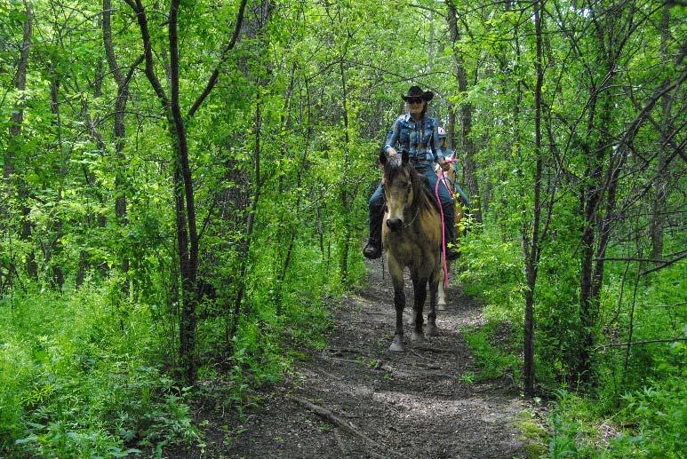
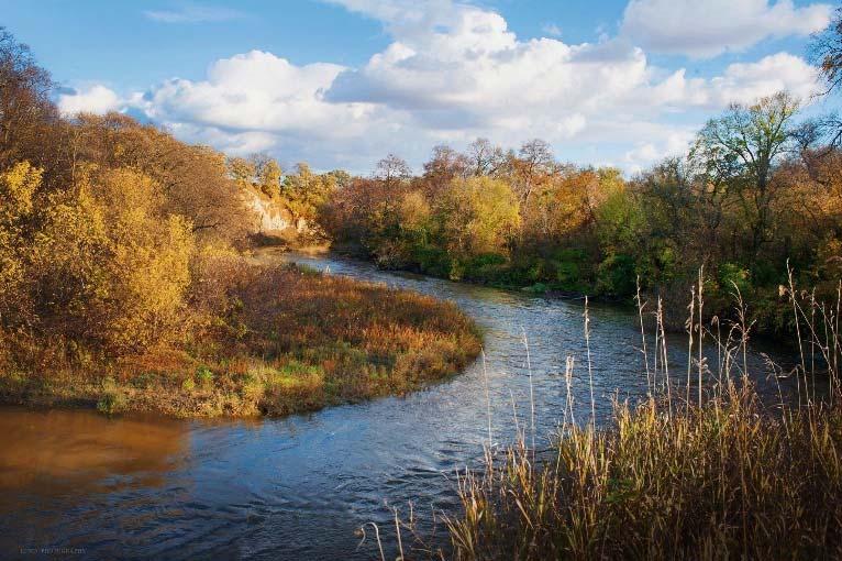
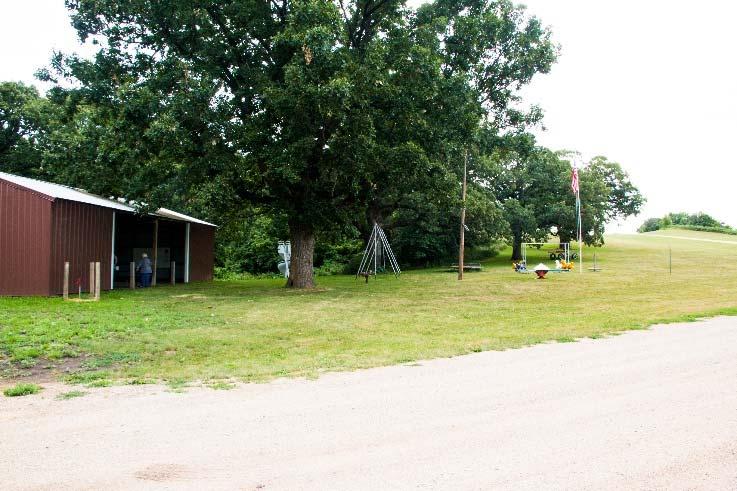
4 Classification Natural Resource Based Regional Park. Overview/Description of Park or Trail GENERAL DESCRIPTION OF THE PARK OR TRAIL Lac qui Parle County Park is a 226-acre naturally beautiful landscape that straddles the Lac qui Parle river, a winding river whose origin reaches west to the Buffalo Ridge of eastern South Dakota. Native Americans likely used this protected place as a safe haven from the prairie winds in their seasonal migration between the Dakota prairie to the Minnesota River Valley. The Nash family became some of the first settlers to secure U.S. Government land patents in the late 1800s. The Nash ownership and with the river lands being quite heavily forested, the Park area quickly became known as Nash's Grove and remains today as a winter sliding destination. Atop a hill on the north side of the park lies the remains of a cemetery whose common stones tell a story of children dying of disease. The local saddle club has spent some 25 years clearing and maintaining trails that are used year around by hundreds of people for riding and hiking. The park features several outlooks from the top of river bluffs and landings below them. Several of the landings offer viewing of the expansive outcropping that flanks the Lac qui Parle River. OVERVIEW OF USER GROUPS THAT WOULD BE SERVED The county park is used by several groups such as the boy scouts, girl scouts, school cross country, school scientific studies classes, saddle clubs, 4 H clubs, snowmobile club, history groups as well as campers and nature enthusiasts. With the project improvements, we expect the trail to draw even more groups to the park. There are no fees attached to this park. Elderly, low-income, minorities and persons with physical disabilities are able to enjoy this park, and will have more opportunities after project improvements. OVERVIEW OF TYPE, SIZE AND SCALE OF FACILITIES TO BE PROVIDED The park currently has two sides of the park, separated by the Lac qui Parle River. There are currently 6.6 miles of trails available to horseback riding, biking, hiking and strict ATV use (speed limits and certain classifications only). Archery is
5 allowed in the park. Winter use includes snowmobile, cross country skiing and sledding. The park does not currently have electricity. The west side has a primitive shelter, an outhouse, minimum maintenance roads that lead to some trails, a rope swing and the old cemetery that dates to the origins of the park in the late 1800s. The east side of the park has a picnic shelter with a cement pad, two pit toilets, a solar powered well, old playground equipment, an area for primitive group camping with fire rings, a sledding hill and access to the river for canoeing and kayaking. There are multiple new facilities proposed in the master plan including a trail head, restrooms, a bridge that crosses the river (pedestrian), and a warming hut. OVERVIEW OF PROGRAMS TO BE OFFERED] The park currently hosts a number of events. An annual three-day equestrian ride through the park is a fundraising event for St. Jude s. The park hosts an annual haunted hayride that serves as a fundraiser for the park. In the spring, the boy scouts use the park for a spring camping experience. Total Acreage or Mileage Lac qui Parle County Park currently covers 226 acres. The total existing trails is about 6.6 miles. The master plan includes trail improvements that will give the park a total of close to 9 miles of trails. Acquisition and Development Status Many acquisition areas identified in the master plan will improve access in the park, and provide buffers important for protecting sensitive areas. Conversations are being had with neighboring landowners. The park hopes to acquire more land as opportunities present themselves Regional Context Lac qui Parle County Park is a county park. It is currently managed and maintained by the Lac qui Parle County Park board and sustained by the members of the local saddle club, local volunteers and Lac qui Parle County. Lac qui Parle County Park is located 5.5 miles south of Lac qui Parle State Park. Lac qui Parle State Park is managed by the Department of Natural Resources as part of their state park system. Lac qui Parle State Park features trails accessible by foot, historic Fort Renville and Lac qui Parle mission sites and a 33,000-acre Lac qui Parle Wildlife Management Area. Popular activities in Lac qui Parle State Park are camping, fishing, bird Watching/winter eagle sightings, hunting, canoeing and cross-country Skiing. Lac qui Parle State Park is also accessible from the County Park by river - a great way to connect the two parks is that one can put in a kayak or canoe and use the Lac qui Parle River to paddle to the Lac qui Parle State Park. Lac qui Parle County Park is located 31.4 miles northwest of Upper Sioux Agency State Park. Upper Sioux Agency State Park contains the site of the Upper Sioux or Yellow Medicine Agency. The park was established in 1963 to preserve and interpret the remains of the old Agency site. The park covers 1,280 acres and offers diversity: open prairie knolls, bluffs, and cool, wooded slopes. From vistas, visitors enjoy the trails which are ideal for horseback riding, hiking, skiing, and snowmobiling. The park also offers a huge sliding hill for winter fun. Popular activities in Lac qui Parle State Park are camping (including tipi sites), historic sites, horse trails/camp, varied landscape/hiking trails and birdwatching. Farming is a large part of the economy in West Central Minnesota and Lac qui Parle County is no exception. As a result, much of the land in Lac qui Parle County (and West Central Minnesota) is used for agriculture and local concerns can make it difficult to remove any land from farming for more park space. There are relatively few preserved natural areas in West Central Minnesota that can boast the both the quality and size of outdoor experience that Lac qui Parle County Park offers to West Central Minnesota.


6 Lac qui Parle County Park may have an opportunity to complement and connect to Lac qui Parle State Park. The County Park offers different recreational experiences such as horseback riding and kayaking experiences that are not available at the state park. The county park also offers a more rustic, river experience that appeal to a different group of users. The Lac qui Parle River connects the two parks. Regional Map Uploads
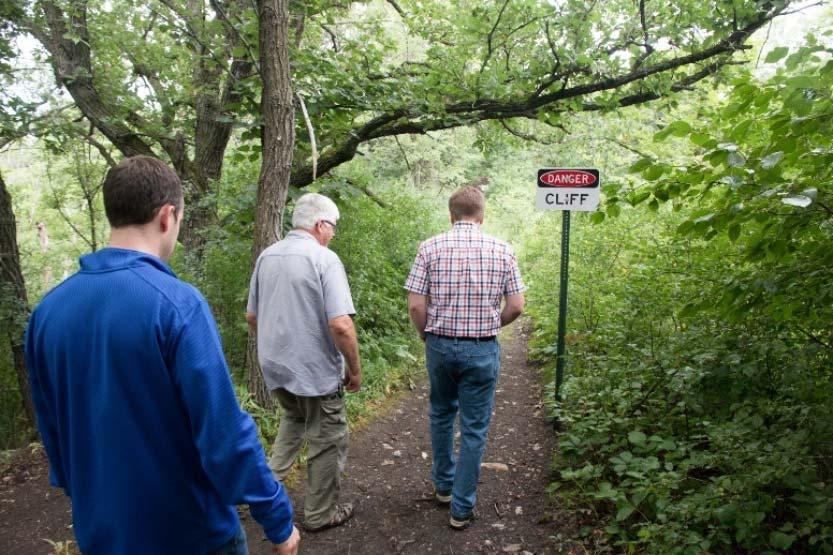
7 3. Site Information Tab Existing Facilities Camping-cross-section of camper types Electric/water/sewer RV sites Electric/water campsites Electric campsites Non-electric campsites Group campsites Tent only sites Camper Cabins OTHER CAMPING RELATED Special equestrian events are held near the shelter area allowing room for horse pens, horse trailers and self contained recreational vehicles Picnicking and picnic shelters Walking Trails (paved) Hiking Trails (natural) Biking Trails (paved) Mountain Biking Trails (natural) Cross-country Skiing Trails Horseback Riding Trails (natural) Swimming Lake Access for power boats Canoeing Facilities Fishing Piers Visitor Center Nature Center/Interpretation Trails Play areas, with an outdoor theme Dog Parks Archery/Shooting ranges Climbing (natural/man-made) Zip Lines Restrooms/sanitation building Roads and Parking Areas OTHER ATV allowed on certain trails with strict rules (speed limit and only certain classifications allowed) Historic cemetery Sledding Hill Rope Swing
8 Proposed Facilities Camping-cross-section of camper types Electric/water/sewer RV sites Electric/water campsites Electric campsites Non-electric campsites Group campsites Tent only sites Camper Cabins OTHER CAMPING Picnicking and picnic shelters Walking Trails (paved) Hiking Trails (natural) Biking Trails (paved) Mountain Biking Trails (natural) Cross-country Skiing Trails Horseback Riding Trails (natural) Swimming Lake Access for power boats Canoeing Facilities Fishing Piers Visitor Center Nature Center/Interpretation Trails Play areas, with an outdoor theme Dog Parks Archery/Shooting ranges Climbing (natural/man-made) Zip Lines Restrooms/sanitation building Roads and Parking Areas OTHER ADA trails with crushed granite Kayak Launch Warming house Electricity Water on west side of the park Holding tank for sewer Restroom with showers Bridge that crosses the river.
9 General Site Characteristics Lac qui Parle County Park s Regional Setting Adapted from the attached document by David Craigmile. The landscape of the park was created by the glaciation that ended some 13,000 years ago with the melting ice waters initiating major portions of local waterways, rivers and streams to include the Lac qui Parle River which flows through the Park on into the namesake Lake and Glacial River Warren Minnesota River & Valley. Thus, the landscape with its till, soil, morphology, water, flora, fauna and climate came first with humans choosing to move into the area to take advantage of these abundant natural resources. There is local evidence of native people being in the area for at least 9,000 years. The Park was claimed by a number of entities before it became part of the United State. The first claim on Park lands by non-aboriginals was by France in 1682, then by Spain in 1763, back to France in 1800, then by the United States in 1803 after the Louisiana Purchase, although the Dakota people still lived on these lands. In 1851, a treaty negotiated that the land be part of the Dakota reservation, but it wasn t until 1859 until the park area became official Dakota Reservation lands. On February 16, 1863, because of the US Dakota War of 1862, the U.S. Senate abrogated all treaties with the Dakota people. Once again, the Park lands changed ownership and again became lands of the State of Minnesota which would become available for general settlement. French traders gave the river which runs through the Park the name Beaver Creek for its abundance of beaver. The Dakota people's name for the river was Watapan Intapa meaning "river at the head". The French later misinterpreted the Dakota name and came up with the French word, Lac qui Parle, which means "lake that talks" assigning both the river and lake that the rivers delta created in the underfit Minnesota River Valley the same name. The first settler land claims in the Park list the lands as Sioux Indian, the county as McPhail and the township as Cerro Gordo. It was not until March 6, 1871 that Lac qui Parle County was officially named as such and set-off from Redwood County. And it was not until December 27, 1872 that Lac qui Parle Township was created by splitting off the east half of Cerro Gordo township. The Park lands finally had official residence in the official township of Lac qui Parle within the official County of Lac qui Parle through which flowed the Lac qui Parle River on into Lac qui Parle Lake. The first settlers to secure U.S. Government land patents in section 30, T118-N R42W of Park lands were Rosetta H Mills (1871), Edwin Nash (1872), Amund Olson (1872) and John Nash (1873); directly adjacent in the W 1/4 of Section 29 was Peter F Jacobson and Hans Hansen (1871) while another Nash, Thomas M (1873) claimed land adjacent in section 31. With all the Nash ownership and with the river lands being quite heavily forested, the Park area quickly became known as Nash's Grove. Numerous 2-4 acre parcels of these valuable river bottom lands timber were surveyed and sold off to individuals, some of whose families still hold those lands today as deer hunting parcels. Original surveys as early as 1872 have been found and are of high quality such that the official stone and tree monuments noted may be located. These surveys could be used and set-up in an activity version of today's popular geo-caching. The early settlers of the Park area decided they would wish to establish a church and city; however, there was quite a discussion as to whether the church (especially) and city should be north or south of the Lac qui Parle River. The first church was organized June 1, 1870 and recognized as the first Lutheran Church in the County as well as Upper Minnesota Valley. Church services were held in local homes or outdoors in timber on the south side of the river. And in April of 1871 the congregation expressed interest in a potential church & cemetery site near the center of section 30, north of the river on land owned by Amund Olson. Land owners William Mills (father of Rosetta H who married Charles Nash), Peter Jacobson and Edwin Nash south of the river talked of donating land and plated out parcels of their lands for the city, church and cemetery. The town was to be called Bison City or Williamsburg which
10 would hopefully become the new county seat boom town; thus, a store was quickly opened in 1870 by a Mr. Donaldson. However, there was competition from another faction of settlers some three miles to the east for another town site to be called Lac qui Parle Village. This competition for a prospective county seat town site would be settled by the first elected County Commissioners; thus, a spirited political campaign ensued to elect the appropriate three persons as originating County Commissioners. The newly elected commissioners first met January 11, 1872 and they voted unanimously to select Lac qui Parle Village as the county seat. That was the death knell for Bison City and the Donaldson store packed up and quickly moved to Lac qui Parle Village. The new church site selection was not quite yet decided as the congregation did not wish to have their church at Lac qui Parle Village, but did prefer it to be centrally located in the vicinity of section 30. Amund & Gorgina Olson Vold owning a one acre parcel of land north of the river in the NW 1/4 of section 30 officially sold it to the Lac qui Parle Branch of Evangelical Lutheran Church in America for $1.00 with a deed dated April 16, The congregation had tentatively chosen the site earlier and started a cemetery there but then decided the location was unsuitable for the church structure as there were problems with accessibility. The church was eventually constructed one mile due west of the described cemetery on donated acreage and is still active on the same site today which is north of the Lac qui Parle River and easily accessible. The original cemetery site is presently within Park boundaries and is very solemn and picturesque. As time marched on into the 20th Century, Park area lands changed ownership; however, people continued to enjoy visiting, hunting, fishing and recreating in the Park area as well as paying respects at the original cemetery. The Minnesota Army National Guard found the Park accommodating, for in the 50's - 70's the local National Guard units practiced maneuvers and honed their marksmanship skills in the Park during weekend drills. The former horse, ox and cart trails once again felt the pounding of hoofs as area and distant saddle clubs found the Park very enticing. The area Boy & Girls Scouts often camped at the Park with the Boy Scouts engineering a bridge across the river. And area 4H Club projects helped tidy up the cemetery and other areas. Class reunions also became common at the Park. In 1968, a grant from the Minnesota Department of Natural Resources allowed Lac qui Parle County to acquire acres to create a public park. Moving into the 21st Century, area schools began using the Park as an outdoor natural and earth science classroom. A particular feature of the Park is the unique riverine fluvial geomorphic landscape with sheer 60 foot cut-banks and associated features. This unique combination of landscapes also provides habitat for a diverse variety of flora and fauna. The Park also began to host a very popular Halloween Haunted Hay Ride. The Park is truly four-season, for winter months entice people that enjoy skiing, snowshoeing and sledding. No firearms are allowed in the Park; archery hunting is allowed. There are 226 acres in the Park today and a hoped-for expansion of some 65 acres is in the planning stages. The Park is open to the public year around, 24 hours a day, 7 days a week. No other park in the County or surrounding area offers such a rich natural resource experience. The Park is preserving a rich heritage while educating today's generation and conserving substantial pristine resources for the future generations. Site Characteristics Images Upload Attachment: Regional setting by Dave Craigmile

11


12 Photo by Lund Photography


13
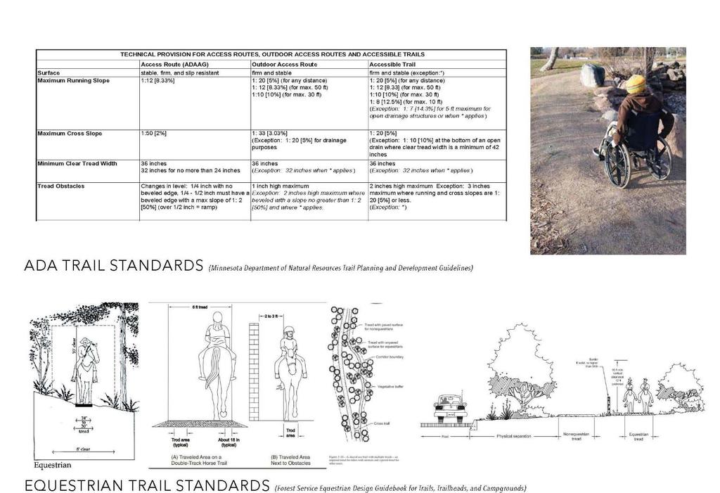
14 4. Trends/Public Values Tab This section summarizes public input, demographics, recreational trends, public values and economic opportunities that influenced master plan outcomes. While most of the rest of the Master Plan describes WHAT will be built, this section details WHY. The Commission expects that all regional facilities will be selected, designed and built based upon solid public involvement and practical research or evidence of demand. Refer to the GMRPTC website (gmrptcommission.org/news) for additional demographic, parks and trails research, and public values information that may be pertinent to this park or trail. Public Involvement Summary VISION STATEMENT Lac qui Parle County Park should be ecologically resilient, accessible to all abilities, and engaging to a wide range of users. Its natural and cultural history should be preserved and highlighted to educate visitors. The park should retain a rustic quality while increasing programming, amenities, and usage. GOALS FOR THE PARK ECOLOGY: Protect and reduce impacts to existing ecological assets while improving degraded habitat. ACCESS: Make the park more accessible to visitors by strengthening the connections between the west and east side of the park, designating trail use, and implementing way finding. AMENITIES: Improve park facilities to expand uses in the park, promote year around use, and attract visitors that won t abuse it. OBJECTIVES ACCESS: 1. Develop trails in areas already influenced by human activity. 2. Connect west and east side of park. 3. Ensure that trails remain sustainable. 4. Create a looped trail network with varied difficulties. 5. Separate trail uses where user conflicts could occur. 6. Create ADA accessible loops. 7. Develop clear wayfinding on site. 8. Provide access to remote areas of the park. ECOLOGY: 1. Remove and restore undesirable trail locations to their appropriate biotic communities. 2. Route trails to bisect ecotones to limit disturbance, avoid erosive ridge-top locations, and provide low-impact stream crossings that supports in-stream habitat. 3. Utilize boardwalks, raised trails, and other topologies that respond to sensitive vegetation and reduce erosion. 4. Stabilize stream bank erosion by restoring shoreline plant communities and using bio-engineering interventions on severe cutbanks. 5. Provide and restore 100 buffers along riparian zones to reduce overland flows and provide upstream stormwater catchment in an effort to reduce nutrient flow, sedimentation, and promote infiltration.
15 6. Remove invasive species and enhance existing native communities to support wildlife habitat and functioning plant communities shoreline, woodland, and upland zones 7. Restore prairie habitat in open fields to support soil health & reduce overland flow, support grassland birds and pollinator habitat, and support native haying activities 8. Limit development activities in floodplains, sensitive ecological areas, and provide instream-interventions that support in-stream habitat 9. Introduce management regimes to regularly monitor and manage invasive species, and support long-term native plant establishment AMENITIES: 1. Promote year-round use by providing facilities that can be heated in the winter. 2. Provide facilities that do not require staffing. 3. Consider the maintenance of proposed improvements and sustainable funding. 4. Park amenities should highlight cultural and environmental resources while providing an opportunity for education/interpretation. 5. Developed areas should avoid flood prone and ecologically sensitive areas. 6. Consider visitor safety when locating amenities and trail alignments. COMMON THEMES, TRENDS AND VALUES OF THE PUBLIC 1. Park is rustic and peaceful, and should be kept that way. 2. Make the park more accessible, enhance what is there, and add amenities sparingly. DEMAND Users are currently all ages. They hike, horseback ride, run, canoe and use ATVs. They want a bridge, electricity, bathrooms and better trails. Hiking and the Haunted Hayride were the highest use in the park. PRIORITIES AND KEY OUTCOMES FOR THE PARK 1. Keep people safe 2. Enhance visitor experience 3. Make the park accessible to the public 4. Signage 5. Trail improvements, esp for runners 6. Clarify usage 7. Reduce invasive species 8. Keep the park attractive to those who will take good care of it. COMMITTEE MEMBERS INPUT Current key message: The Lac qui Parle County Park: preserving a rich heritage while educating today's generation and conserving substantial pristine natural resources for future generations. Preserving the value of the County park by respecting it as a natural resource and its native history. Most importantly is that the county park is a public place to be enjoyed and respected by everyone. In a sense it s a memorial to be preserved for its natural history as well as the history of the people that came before us. It was meant to be a public space. That means nobody owns it and no single group has the right to control or dominate its use. It s a public place.
16 CHALLENGES AND CONSIDERATIONS (1) Mixed uses of the park ATV, horses, humans. It was decided to continue the mixed use of many of the trails, but to have share the trail signage, and to have strict rules for ATV use (speeds under 7 MPH, only certain types allow). (2) Maintenance of proposed improvements and sustainable funding. The county board will be approving the improvements with the idea of maintenance costs. (3) Overnight camping and increased usage for a park that is not staffed. Some of the ways to address this will be: clear rules on signage, county sheriff alerted to the rules and will monitor the park, surveillance cameras to be used, and to have the park appeal to those who will take care of it. It is also recognized that the park staffing etc. may need some changes if/when usage increases. (4) Safety hazards and bank stabilization. Trails will be designed with bank stabilization in mind. Uses for the trail will also consider ecological impact and erosion, as well as safety. PUBLIC INVOLVEMENT The Lac qui Parle County Park Master Planning process involved a very robust public engagement effort. The following activities helped get the public s input for the park: (1) A PUBLIC SURVEY in the fall of We receive 255 online and paper surveys through the following outreach methods: * Facebook page * Lac qui Parle County Fair booth * Haunted Hayride October 25, participants and 144 paper surveys * Distribution by steering committee members * Local school cross country practice, and s sent to cross country parents * Newspaper ad and radio ad * St. Jude Equestrian Ride Out of the 255 surveys, 55 people use the park less than once per year. The following information is taken from the 200 responses who answered they used the park daily, weekly or at least once per year. The following are the top responses (number of responses): Who uses the park? Highest age group was (74) but all age groups were well represented. What do you do? Top votes were: Haunted Hayride (103), Hiking (97), Sledding (68), Camping (55), Horseback riding (54). Next: ATV, Fishing, Other, Swim, Birding, Archery/bow hunt. Top write-in was trail running (9). What would you like to see added? Bridge (126), Electricity (86), Ski Trails (44), Hunting (27), write- in: playground equip and warming house What would you like to see improved? Bathrooms (93), Trails (77), Shelter (51), write-in: electricity, lights, showers
17 (2) PUBLIC DRAFT OF THE PLAN available online on the umvrdc.org website and on the LQP County Park facebook page. Outreach was done with: * Facebook * s collected from the survey were sent notification of the draft plan and public meeting notice. * Advertisements - radio (3) PUBLIC MEETING Add information after meeting (4) STEERING COMMITTEE MEETINGS Steering committee #1 held August 24, 2017, Lac qui Parle County Park Introduction, timeline, case studies, public engagement strategy and challenges and opportunities. Attendance: Park board: 11 Staff: 2 Steering committee #2 held December 14, 2017, Riverside Town Hall, Dawson Survey results, identify common themes, demand, trends and values, full analysis and inventory of the park, possible amenities, potential funding models. Attendance: Park board: 8 Staff: 3 Steering committee #3 held March 8, 2018, Riverside Town Hall, Dawson Survey summary, draft vision, goals, objectives, draft concepts. Attendance: Park board: 9 Staff: 4 Steering committee #4 held March 22, 2018, Riverside Town Hall, Dawson Single concept, maintenance, ATV usage, priorities and phases Attendance: Park board: 12 Staff: 3 Lac qui Parle County Board presentation April 3, 2018, Madison, MN Update to the county commissioners of the plan with cost estimates and design features. Park board: 4 Staff: 1 An article from this meeting was published in both the Madison and Dawson papers Steering committee #5 held April 10, 2018 Review concept drawing, ATV, programming, outreach, marketing and usage, supporters, immediate projects Park board: 8 Staff: 1 Public meeting held May 8, 2018
18 Dawson: 5:00 6:00 Madison: 6:30 7:30 The plan was available electronically for those unable to attend the public meeting The Master Plan was presented to public for input and suggestions Lac qui Parle County Board adoption date: Public Involvement Support Material Upload Attachment: SURVEY PDF Regional Demographic Information Lac qui Parle County 2010 Population: 7,259; 2010 Households: 3,155. Lac qui Parle County Park is the county s only park, and the only park in the region that offers many of the experiences that Lac qui Parle County Park offers. The park is regional because of the following - This unique park already draws visitors from a larger area because of the unique natural and recreation opportunities such as horseback riding, rustic trails, and river recreation; the topography of the park is unique and offers plant life and wildlife that needs to be preserved; - it offers a regional park in an area where there are few public spaces for people to enjoy camping, hiking, and trails. The population in Lac qui Parle County (and most other rural counties in the United States) have experienced population decline over the past 50 years. The population decline in Lac qui Parle County (again, along with most rural US counties) has slowed, but Lac qui Parle is projected to see more decline over the coming years than its neighboring counties. However, Lac qui Parle Lake is a tourist destination for the region (and the state) due to the high quality of hunting and fishing opportunities. Lac qui Parle Wildlife Management Area is popularly considered the premier goose hunting grounds in the State of Minnesota, which is also largely considered the premier goose hunting state in the US. The region also features a DNR Wildlife Management Area staff. While the population of Lac qui Parle County may be slowly declining, the county still serves as a regional destination for Minnesotans interested in hunting and fishing. Lac qui Parle County Park is currently a regional destination for more than 35 cities in three states, including Bismarck, ND which is over 350 miles from the park. Lac qui Parle County Park also serves as a regional equestrian destination. Riders come from as far as the neighboring states to participate in the event. Park user surveys included responses from 31 Minnesota cities, including: Aitkin, Albert Lea, Appleton, Arco, Bellingham, Benson, Boyd, Canby, Cyrus, Danvers, Dawson, Faribault, Graceville, Grove City, Hancock, Hanley Falls, Hutchinson, Lake Benton, Landfall Village, Madison, Marietta, Marshall, Milan, Minneapolis, Montevideo, Ortonville, Porter, Roseville, Taunton, Watson and Wood Lake. The park user surveys also included responses from the South Dakota cities of Corona and Milbank and the North Dakota cities of Bismarck and Fargo.


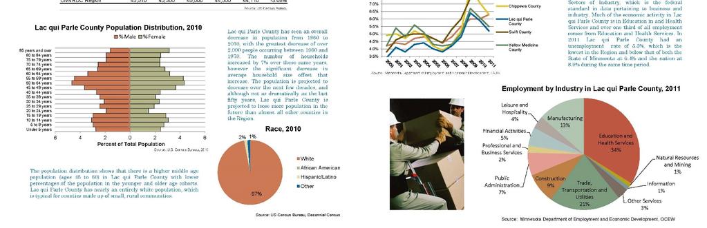
19 Demographic Support Material Upload 2010 Lac qui Parle Census data community profile
20 Public Health Values (Check all that apply) Promotes Physical Activity o Promotes Healthy Lifestyle o Connects People to the Outdoors o Enhances Mental Health o Encourages Social Interaction Public Health Values Additional Information Lac qui Parle County Park can improve public health in several ways including: PROMOTES PHYSICAL ACTIVITY There are currently 6.6 miles of trails. With the improvements, there will be 8.8 miles of trails. The trails in Lac qui Parle County Park make walking and running enjoyable and accessible. The local cross country running teams use the park to train. The equestrian groups use the park for riding horses. There are many people that use the park for walks and getting outside. The park also offers wonderful kayaking, and in the winter, sledding and snowshoeing are available in the park. Proposed projects will promote and enhance these activities, and add cross country skiing, and additional trails. CONNECTS PEOPLE TO THE OUTDOORS: The diverse trail systems wind through woodlands, bedrock prairie, and 60 foot cliffs creating a variation of natural features for users to explore. Park programming attracts overnight campers and day visitors alike. Proposed interpretive signage can help visitors relate and understand the park both culturally and naturally and establish a relationship with the landscape. IMPROVED MENTAL HEALTH: Numerous sources translate the benefits of nature on mental health. According to ASLA.org, "even short periods of time in nature can reduce symptoms of depression. Dutch researchers, who published their findings in the Journal of Epidemiology and Community Health found that living close to parks, or at least near lots of trees, can have far reaching mental health benefits for people. In turn, living in places without parks or trees, especially if you are young or poor, can have major negative impacts." ( Located centrally in an area with sparse large parks, Lac qui Parle County Park offers a reprieve from daily life and serves as regional destination for campers and outdoor enthusiasts. PROMOTES HEALTH LIFESTYLE Passive and active recreation programming proposed for Lac qui Parle County Park encourages residents and visitors to get outside and engage in physical and mentally beneficial activities. Programming in the park supports social interactions (event spaces and pavilion), educational opportunities (signage), active recreation (trails and sports), and moments for reflection (memorials and vistas). ENCOURAGES SOCIAL INTERACTION: Programming (Haunted Hayride) and the park shelters offer space for both public and private events. Rentable spaces could host events such as painting in the park, town meetings, weddings, and more. Trail systems support group hikes and rides. Camping spaces, fire pits, and outdoor classroom space supports gathering and conversation both formally and informally.

21 Public Health Values Support Material Upload Economic Development/Tourism Opportunities Lac qui Parle Lake and Wildlife Management Area (WMA) is a tourist destination for the region (and the state) due to the high quality of hunting and fishing opportunities. Lac qui Parle WMA is popularly considered the premier goose hunting grounds in the State of Minnesota, which is also largely considered the premier goose hunting state in the US. Migrant geese begin arriving in mid-october and the numbers in Lac qui Parle State Park will peak out between 125,000 and 150,000 birds. The region also features a DNR Wildlife Management Area staff. A Wildlife Area Supervisor along with two full-time staff and five part-time seasonal staff oversee the WMA work area totaling 33,000 acres. This acreage includes a state game refuge, a wildlife sanctuary, a waterfowl feeding and resting area, a duck sanctuary and a controlled hunting zone. Lac qui Parle County Park is currently a regional destination for more than 35 cities in three states, including Bismarck, ND which is over 350 miles from the park. Lac qui Parle County Park also serves as a regional equestrian destination. The park hosts a very popular equestrian event to raise money for the St. Jude s Foundation. Riders come from as far as the neighboring states to participate in the event. Park user surveys included responses from 31 Minnesota cities, including: Aitkin, Albert Lea, Appleton, Arco, Bellingham, Benson, Boyd, Canby, Cyrus, Danvers, Dawson, Faribault, Graceville, Grove City, Hancock, Hanley Falls, Hutchinson, Lake Benton, Landfall Village, Madison, Marietta, Marshall, Milan, Minneapolis, Montevideo, Ortonville, Porter, Roseville, Taunton, Watson and Wood Lake.

, canoeing and kayaking, fishing,")
22 The park user surveys also included responses from the South Dakota cities of Corona and Milbank and the North Dakota cities of Bismarck and Fargo. Lac qui Parle County Park serves economic development and tourism in Lac qui Parle County by providing a campground, shelter and recreational trails. This attracts out-of-town guest to the area. Once the park is enhanced to provide travelers a better experience with the natural wonders of the park, this tourism will undoubtedly increase. The economic development and tourism in the region created by the park will increase by providing a high quality outdoor recreation area (camping (both tent and RV), canoeing and kayaking, fishing, bird watching, walking/running/bicycling on trails, nature hiking, and picnicking), access to the Lac qui Parle River, access to 60 ft bluffs and rare plant and animal species, and is well connected in the region by the Minnesota River Valley National Scenic Byway. The park is in the Minnesota River Valley National Scenic Byway (MRVNSB) corridor (10 miles on both sides of the Minnesota River). Attached is a section from the MRVNSB Interpretive Plan that talks about Visitor Demographics, Preferences and Behaviors. In a study done by the University of Minnesota Tourism Center, 6% of southern travelers stay in an RV at a campground and 3% stay at a tent in a campground. Nearly half of visitors are from Minnesota. Lac qui Parle State Park, just ten miles away, gets 96,000 annually. Economic Development/Tourism Opportunities Support Material Upload 60-ft bluffs in the park
23

24
25

26


27


28

29
30
31 Recreational Trends Information The Lac qui Parle County Park currently offers the simplest amenities, and takes some work and luck to be able to visit and enjoy what it has to offer. There are few signs, and unless you know the park, you would not know where to go to enjoy the trails and views. The roads and trails are not accessible in times of bad weather, and only certain vehicles can access the minimum maintenance roads. Our user survey showed the following: Of the 255 people surveyed, 19% use the park less than 1 x per year. Around half of the surveyed people use the park at least 1 x per year. People in the age group are the highest user of the park. 67% would like to see a bridge over the river 48% would like to see electricity added to the park. 61% would like to see bathrooms improved 41% would like to see trails improved. Expanded programming and accessibility in Lac qui Parle County Park will not only attract increased local usership but will also support the site as a regional recreation destination. There is great opportunity and demand for facilities and amenities to be offered in this park which will increase usage. Facilities and amenities such as an outdoor classroom, good trails and roads, a spot for buses to get in and turn around, bathroom facilities in areas around the park, interpretive panels, ecological restoration, and signage would address the demand to use the park and enable accessibility. Improved park facilities will support wedding events, community gatherings, and other private event rentals while the enhanced ecological character of the site and engaging interpretive elements draw hikers, bikers, families, and other outdoor users to the site. Recreational Trends Support Material Upload Attachment: Survey results

32


33 5. Classification Details Tab #1 Criteria 1: Provides a High Quality Outdoor Recreation Experience Lac qui Parle County Park is a great location to get outside and enjoy natural resource-based outdoor recreational activities. The Lac qui Parle River flows through the park allowing opportunities for recreation such as fishing, canoeing, kayaking and swimming. The park is home to many miles of trails for walking, hiking, bicycling or horseback riding. The park is also home to many wildlife species and unique plant species. The park features several outlooks from the top of river bluffs and landings below them, so of which are 60-ft tall. Several of the landings offer viewing of the expansive outcropping that flanks the Lac qui Parle River. If you are looking for a place to unwind and reconnect with nature, Lac qui Parle County Park is the place for you. There is a shelter with picnic tables, there are fire rings, primitive bathrooms soon to be improved and new hydrants for drinking water.


34 Proposed facility and amenities will make this park more accessible to the public and provide a high-quality experience in a park that is a hidden gem. Many of the current facilities such as the playground equipment and shelter need upgrades, and the county has recently decided to focus their attention to improving the facilities and recreational opportunities so they can attract new visitors from a wider area and get more visitors to become repeat users of the park. They see Lac qui Parle County Park as a tourism and economic development asset to the county and the region.


35


36 Criteria 2: Preserves a Regionally Significant and Diverse Natural or Historic Landscape The Lac qui Parle County Park is a natural and primitive park. The landscape transitions from wooded river bottom to natural grass prairie meadows. There is no other place like Lac qui Parle County Park in western Minnesota. The landscape along the river varies widely. When visiting the park you will find areas that flow gently from a hill top down to the river. In other areas you will find a steep clay cliff dropping some 60 feet to the river channel. The park is a great place for watching birds and other animals including but not limited to whitetail deer, beaver, wild turkeys and squirrels. The park is truly an important home for rare plant communities such as jack in the pulpit, and offers the high-quality habitat needed for the spiny softshell turtles who thrive in the park. Lac qui Parle River and Rapids Cemetery


37 60-ft bluffs Photo by Lund Photography Spiny softshell turtle location Jack in the Pulpit


38 Criteria 3: Well located to Serve a Regional Need and/or Tourist Destination The park is located near US Highways 212, 59 and 75. If you are traveling through the area, it is likely you will be on one of these highways. Lac qui Parle Lake and Wildlife Management Area (WMA) is a tourist destination for the region (and the state) due to the high quality of hunting and fishing opportunities. There are also many tourists in the area for the Meander Art Crawl, a fall weekend where local artists open up their studio and shops to visitors and share their talents. Throughout the spring and summer avid bird watchers frequent the area. The annual Audubon Society Salt Lake bird count find the county park to be one of their destinations. In the spring and fall local high school cross country and track teams will use the terrain in the park to train. Lac qui Parle County Park is currently a regional destination for more than 35 cities in three states, including Bismarck, ND which is over 350 miles from the park. Lac qui Parle County Park also serves as a regional equestrian destination. The park hosts a very popular equestrian event to raise money for the St. Jude s Foundation. Riders come from as far as the neighboring states to participate in the event. The population in this region is much less dense than many other areas in the state, but quiet roads make accessing this park very easy and quick for people that are even miles away. It is approximately 10 miles from Madison, Dawson and the Lac qui Parle State Park, making it serve a regional need for a large area. It is easily accessible from Marshall, Watertown, SD, Alexandria and Willmar, all large regional centers in western Minnesota.


39 Criteria 4: Fills a Gap in Recreational Opportunity within the Region (300 word limit) There are not many parks in this region that offer the high quality natural experience that the Lac qui Parle County Park offers. This park has more acreage that neighboring parks, and the topography is more dynamic than any park in the region, including the Lac qui Parle State Park. The closest county parks are located in Yellow Medicine County or Chippewa County, and they do not offer the same natural experience. The trails in the park are exceptional for hiking, running and mountain biking. The area in the park known as Nash's Grove has been a sledding destination for many generations. The park is used by local cross-country teams to train, as it has hills and trails not found for miles around. One gap that is filled is horseback riding. The saddle clubs and individuals have been riding the trails for over 60 years. Each year the trails need to be groomed and kept up for the riding season. There are riders that come from all over Minnesota, South Dakota, North Dakota, Wisconsin and Iowa. There are scheduled rides, sponsored by the saddle clubs and one large ride for St. Jude Children's Hospital. There are groups of two to ten that come to ride on their own on weekends and there is a 4-H group that has more than 20 riders at a time. The St. Jude Children's hospital Labor Day Ride has over 100 riders. A recent visitor from Milbank, SD stated I love the county park! I go there every year for the Labor Day St. Jude fundraiser ride and any chance I get. When people ask where I ride, I tell them that you need to go to the Lac qui Parle County Park!
40 6. Development/Acquisition Plan Tab Development Plan Overview The re-envisioned Lac qui Parle County Park transforms the currently underutilized public amenity into a regional destination for outdoor recreation and environmental exploration. The proposed master plan divides the park into multiple zones to offer visitors a diversity of camping opportunities, trail experiences and day-trip amenities while enhancing the ecological character of the park that highlights and preserves its rich cultural, ecological, and geologic history (see attached Concept Plan Zones map). All proposed features will meet regional design and applicable accessibility standards. The re-envisioned Lac qui Parle County Park looks and feels like the same rustic, peaceful park but with some subtle yet important improvements that transforms the currently underutilized public amenity into a regional destination for outdoor recreation and environmental exploration. These changes will allow the user to enter the park and feel they are walking back in time, and have ample opportunity for safe, outdoor experiences. The proposed master plan divides the park into multiple zones to give a structure in the park improvements and to help with phasing the work. Development Plan Items/Images Upload

41
42

43 Acquisition Plan Overview There is no additional land acquisition currently underway, however, in the future, the City does have interest in acquiring adjacent properties. The 80-acre parcel to the north of the west entrance would prove additional acres for trails. The 16 acres to the east would provide an important buffer for the park and its trails. Acquisition to the north of the park (3 acres, 6 acres) offer new access point to the park. Finally, there is a 40 acre parcel that is a low priority, however the east side of that parcel may be useful for access to the park. It is included as a potential acquisition in the future. There are also two parcels within the current park boundaries that are privately owned. If these parcels were to be acquired, it would allow the park to give public access to another section of the park. Currently, there are no ongoing discussions with the landowners, although they have been approached and are aware of interest from the Lac qui Parle County Park. Acquisition is likely to occur as a later phase to the redevelopment of Lac qui Parle County Park. Acquisition Plan Items/Images Upload

44 Development Feature and Development Feature Support Material Upload Development features West Entrance Road Improvements (Existing to be improved) Currently, the west entrance road easily fills with snow, and has large ruts. The road needs improvements such as raising the road and paving to mitigate against becoming snow filled and damaged. east park Entrance Road improvements (Existing to be improved) Currently, the east entrance culvert is undersized and needs replacing to prevent further erosion. Bridge (New) Public demand was high for a bridge that connects the two sides of the park. The plan is to have a 12 bridge that is equipped for vehicles to cross for limited/emergency use, but primarily used for pedestrian and multiple uses such as fishing, biking, walking, and snowmobiles. This bridge should have an area for fishing, and accommodate multiple uses and modes of transportation (biking, walking, etc.).

45 Signage (New) Signage is a large need in the park. Both entrances need signage. Signage is needed at the park boundaries. Because the park is not staffed, park rules will be posted on signage at the entrances and in multiple areas. Trails will also need to be signed to show the usage allowed, and to explain how they can share the trail with multiple uses (all yield to horses, etc). There will also be a main kiosk at the trailhead as a point to get all park information and to learn about the history of the park. Finally, there will need to be wayfinding and interpretative signage throughout the park it is identified at the North Loop, Park Loop, and Wetland /Kayak loop Summary: - Monument signs at both entrances - Park boundary signage - Park rules signage at both entrances and in multiple areas o Trails usage, share the trail signage - Main kiosk at trailhead - Wayfinding & Interpretive Signage North loop, park loop, Wetland /kayak loop Trails (New and Existing to be improved) All the trails need to be designed and developed in the park. There are 6.6 miles of existing trails. When all the proposed trails are completed, there will be close to nine miles of trails in the park. The main loops will have ADA trails with crushed aggregate and sections of boardwalk. Equestrian trails will be both single track and double track. The park will allow ATVs on the trails in most areas, but will have strict speed limits, and will also limit the types of ATVs allowed in the park. There will be some trails where ATVs are not allowed except for maintenance of the trails because of the sensitive ecological impacts. Summary: ADA trails North Loop, Park Trail Loop and Wetland/Kayak Loop with Boardwalk Equestrian Trail single track and double track Hiking trails Beach Area and Acquisition and trail restoration west


46

47

48 Kayak Launch (New) A new Kayak launch will be built in addition to the existing launch to create a blue trail within the park. The water trail between the two kayak launches has rapids, making it one of the more desirable stretches for kayakers along this stretch of river. Wetland and kayak loop, Bridge area Fishing Pad (NEW) A fishing pad would go west of the existing shelter and just below the rapids. This area was identified as a deep channel that is good for fishing. Snow hill Improvements (Existing to be improved) The snow hill has erosion issues and needs some restoration to stabilize the slope. Beach Rehabilitation (Existing to be improved) The beach area was defined as an ecologically significant area and has been over impacted by human use, such as camping. Proposed improvements include restoration and picnic tables that define human use areas. Land Acquisition (New) There are multiple areas around the park identified for acquisition. The areas to the east will allow for a buffer to reduce overland erosional forces and to allow for a new trail to connect currently inaccessible remote areas of the park. Areas on the west side of the park will allow the trails to expand and add another section of beautiful area of the park. Areas on the north side of the park will allow another access point into the park and allow for a larger blue trail network to be created. Prime farmland is not a priority for the acquisition for the park. Pioneer Cemetery Improvements (New and Existing to be improved) There is an abandoned cemetary located on site that has headstones dating back to the 1880 s. The cemetery is neglected and is in needs of a new fence, signage, and some headstone/monument repair to prevent further deterioration. This area is also a landscape anchor and provides sweeping views of site, amenities such as seating, a small picnic shelter and pit toilet were identified for this area. Summary: Fence, signage, seating, picnic shelter, pit toilet, rehab monuments


49 Playground (New replace) New playground equipment is needed in two areas. One is at the new trailhead area. The second would be to replace existing playground equipment in picnic/play area on the east side of the park. Trailhead area (new), Picnic/Play area Pit toilets (New, Existing) Cemetery, North loop Pit toilets should be placed strategically around the park to allow for better access and amenities. Some areas identified are the cemetery, and beach area. There are currently three toilets in the park one outhouse, one new vault toilet by the shelter, and one primitive pit toilet in the current camping area.


50 Camping (New AND EXISTING TO BE IMPROVED) The current camping areas in the park are very primitive. Camping will be developed in the park to accommodate RV sites with water and electricity, tent camping, group camping and camper cabins. This will be phased. RV Sites these sites will be back in and pull through. The first phase may plant trees and create the campground areas, awhile water and electricity could be added in a later phase. A pay box will also need to be added. Tent campsites these have been identified in an area where there are nice trees for camping under. Invasive species will need to be removed, and tent pads, fire rings and a picnic table added to the site. Group camping There is currently a group camp on the east side of the park with two pit toilets, primitive fire rings, and access to the main shelter. We recommend that this area continues to be used for informal group camping with some improvements to provide designated parking areas, new fire rings, and tent pads.


 picnic/play area The main")
51 Camper cabins there is a space identified in the plan for camper cabins, which can be a good revenue source for the park. Summary - RV sites with water and electricity - Tent Campsites - Group Camp - Camper Cabins Main Shelter (Existing to be improved) picnic/play area The main shelter needs repairs to the floor.
 North Loop, Acquisition and Trail Restoration Gathering nodes have been identified for two areas of the park.")
52 Warming House on east side (New) - Play/park area, need electricity A true warming house is needed near the sledding hill which is near the Main Shelter on the east side of the park. Electricity will be needed for this building. Gathering Nodes (New) North Loop, Acquisition and Trail Restoration Gathering nodes have been identified for two areas of the park. This includes a picnic table, bench and gravel pad. A small shelter may be useful on the north loop area. Primitive Shelter and Outhouse (existing) The shelter at the west entrance was built by the built by the equestrian club and is useful for the saddle clubs. There is an existing outhouse in this area. Other than some landscaping and signage, no improvements are planned for this site. Trailhead Building (New) The trailhead building on the west side of the will provide visitors with running water, bathrooms, showers, interpretation, an inside gathering place, and a seasonal warming hut. There will be parking available so buses can easily turn drop off students. This area will need utilities electrical and water. Sewer holding tanks will be pumped. Site lighting will be added to this area. Summary: Restrooms, Showers, Warming Hut, Kiosk, Parking Utilities- Run electrical, Water and Site lighting Utilities (NEW, EXISTING) Currently, there are no utilities in the park except for a solar well installed in 2015 which allows for running water on the east side of the park. The master plan recommends electricity and water to be added to the west side of the park, with the option to run electricity to the east side for a warming house. A full sewer system is not planned; rather a holding tank that will be pumped.

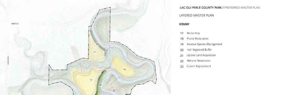
53 Solar well Restoration (New) Ecological restoration is needed throughout the park. During the master plan process we conducted a cursory analysis of the ecological quality on site and made high level recommendations based on site observations and collective map data that included slope analysis, soils and plant communities, and trail systems. We identified areas that were impacted by human activities such as atv use, horseback riding, camping, hiking, and haying practices. We also identified areas of erosion, unbuffered stream banks, and the presence of invasive species including buckthorn (Rhamnus cathartica), honeysuckle (lonicera spp.), garlic mustard (Alliaria petiolate) and reed canary grass (Phalaris arundinacea). Seasonality limited our ability to assess herbaceous and shrub layer native vegetation. As funding becomes available, a thorough assessment of vegetation and habitat quality should be performed by an ecologist as to better determine detailed restoration approaches. Our initial findings indicate that the following areas should be considered for ecological improvements to mitigate impacts of human activity and support water quality improvements along the Lac Qui Parle River: SHORELINE RESTORATION Description: Shorelines showed significant areas of cutbank erosion due to fluctuating river levels. Overland flow from adjacent farm fields, lack of buffers, and channeling of water through steep trail areas are also significant contributors to shoreline erosion. Improvement recommendations include the establishment of native buffers, modifying trail systems, and bioengineering strategies to stabilize shorelines, remove invasive species, and establish stands of native vegetation. Areas: Shoreline improvement area, north loop, beach area, tent camping, bridge and kayak PRAIRIE/ GRASSLAND RESTORATION Description: No stands of native prairie vegetation was observed on site. Potential upland buffers adjacent to the river and existing non-native hay fields present the largest opportunity for native grassland restoration. Transitioning the non-native hay fields to native prairie vegetation has the opportunity to support native haying activities, native seed harvest once established. Additionally, these areas can be phased to become a resource for

 were observed on site. A management through chemical and mechanical removal should be evaluated in future assessments.")
54 future restoration activities on site. Until restoration activities are feasible, the annual hay fields should be kept in haying activities to prevent invasion by perennial and woody species. Areas: Annual Hayfields North Field Area, South Field Area, Park Loop WETLAND RESTORATION: Description: Restoration of wetland areas will include transitioning from invaded wetland to native vegetation. Reed canary grass (Phalaris arundinacea) and cattail (typha spp.) management is the primary invasive vegetation present. Native species such as dogwood (Cornus spp.) and willow (salix spp.) were observed on site. A management through chemical and mechanical removal should be evaluated in future assessments. Trail improvements in these areas should minimize ground contact through the use of boardwalks to prevent increased erosion and protect areas of desirable vegetation. Areas: Beach area, Wetland/kayak loop WOODLAND RESTORATION- OAK SAVANNA: Description: Buckthorn and honeysuckle removal is the primary restoration activity recommended. Significant cover of desirable canopy species were observed and included large bur oaks (Quercus macrocarpa) among other species. Further evaluation of the herbaceous vegetation is necessary. Removal strategies include opportunity for hand removal, cutting, and forestry moving. Management of invasive woody vegetation is essential to limiting spread and should be a priority management effort. Areas: South field, North Loop, Park Loop, Tent Camping, Picnic/Play, Acquisition and trail restoration West WOODLAND RESTORATION- FLOODPLAIN FOREST & MESIC HARDWOOD FOREST: Description: Lowland forests exhibit canopies of desirable tree species with a shrub layer invaded by buckthorn and honeysuckle, as well as an herbaceous layer of reed canary grass in spots. Management of invasive these species should follow strategies described in oak savanna and wetland restoration targets. Further assessment of herbaceous vegetation is necessary to prescribe enhancement recommendations. Areas: Loop, Beach Area, Wetland/Kayak Loop Hayfield Aspen grove


55 Invasive nettle Young oak
56 Outreach, safety and user tracking Communication is identified as a need. The website will be improved to offer more information to users. There will be an online guest book created. A surveillance camera could be utilized both for safety and for tracking users. A counter cable could also track the number of cars the park sees. Summary: - Website improvements - Online guest book - Counter cable - Surveillance camera
57 7. Implementation Plan Tab Implementation Plan Development of Lac qui Parle County Park s features have been divided across five priorities to enable phasing of reconstruction efforts in accordance with the objectives of the park. The goal with the top priorities is to have a high impact on the user s ability and desire to make use of the park, and for them to want to come back. Highest priorities focus on improving core access and safety of the park. The initial phase focuses on the roads and trails on the west side of the park and connecting the two sides of the park with a pedestrian bridge. Signage, including entrance monument signage, is also included in this phase. The second phase enhances the visitors experience by adding park features to the west side of the park. Basic amenities are added such as the trailhead, restroom, south (east) loop trails, existing picnic and play area improvements, east side trails and signage. These things will make the park more attractive to the user while remaining rustic. It will also add ADA accessible features to the park. The third phase improves unique features the park encouraging the user to explore further. The cemetery, beach area and shelters/toilets all need improvements and better accessibility. It also prioritizes some important land acquisitions for the park to offer safety, ecological buffers and better access to the park. Restoration will be done in each phase, but the fourth phase focuses more on the north field restoration, completing the RV park, adding the kayak launch and boardwalks. The fifth phase includes camper cabins, a new playground and shoreline improvements. In the longer-term priorities, efforts focus primarily on diversifying user experiences with the addition of expanded trail networks through varying ecological conditions, cabin camping, and continued ecological restoration and enhancements. These later features go beyond the current park programming to attract visitors over multiple seasons and stay lengths to transform Lac qui Parle County Park into an ecologically and recreationally vibrant regional destination. Summarize Acquisition and Development Costs To Date A 1968 grant paid for acres, which put the park into the ownership of Lac qui Parle County. The total grant was $13,348 with $3,352 as state funds and $9,996 as federal funds. Very limited developments have occurred since. In 2015, a solar well was installed for $20,000. In 2016, a vault toilet was install for $25,000. Other improvements have been procured by donated equipment. Investments to Date from Various Sources Parks and Trails Legacy Funding Acquisition $0 Development $0 Total $0 Non Parks and Trails Legacy Funding Arts & Cultural Heritage Legacy $0

58 Local and Other Funding Sources Clean Water Legacy Funding $0 Outdoor Heritage Legacy Funding $0 Total $ $13,348 DNR local grant ($3,353 state, $9,996 federal) $20,000 solar well donations $25,000 vault toilet $58,348 - total Acquisition and Development Cost Projections Cost projects for the Lac qui Parle County Park Master Plan have been detailed both by priorities as well as by site or program area. Cost estimates for the acquisition have been developed using previous tax records and estimated county land values. Cost Estimate Support Information Upload


59

60 Acquisition and Development Phasing Plan Development of Lac qui Parle County Park s features have been divided into five phases to allow the park to develop the priorities first. Both a bridge and better restrooms were a high priority according to the survey. Trails and improved roads were also a high priority. The phasing also allows the county to take on the development in smaller chucks, making it possible to fund and giving the time for the projects to be accomplished. The phasing works on the core functions of the park first and then expands out to enhance the rest of the park. In the longer-term priorities, efforts focus primarily on diversifying user experiences with the addition of expanded trail networks through varying ecological conditions, cabin camping, and continued ecological restoration and enhancements. These later features go beyond the current park programming to attract visitors over multiple seasons and stay lengths to transform Lac qui Parle County Park into an ecologically and recreationally vibrant regional destination. Phasing Plan Support Information Upload
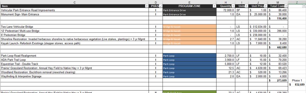

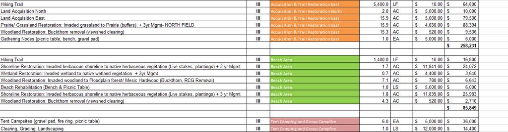

61


62 Cost Projections for Implementation Plan Acquisition $89,500 Development $4,075,544 Projected Total $4,165, Operational Plan Tab Joint Organizations Responsibilities N/A Maintenance/Operations Plan The Lac qui Parle County Park is maintained and managed by the Lac qui Parle County Park Board. Maintenance costs are paid from the county budget and fundraising efforts. Currently trail maintenance and managing the park entrances is done by the park board. Mowing, grading and barricading the park entrances is done by the county highway department and county sheriff. Annual expenses to maintain the park are currently $ Spraying and chemical $ Dumpster $ Garbage pickup $ Septic pumping $ Advertising and promotion $ County park map and brochure $1, Brush clearing $25.00 Insurance
63 $ Property Taxes $ Hayride Fundraising Expenses $5,000 Mowing and grading $8,975 Total maintenance per year Long term management costs of the equestrian trail will need to be figured. It is estimated that annual management of the prairie, shoreline and woodland is approximated at $53,000/year. The Lac qui Parle County commissioners are committed to maintain Lac qui Parle County Park for it visitors. As facilities are added to Lac qui Parle County Park, the Lac qui Parle County commissioners will budget for ongoing maintenance. M/O Support Material Upload Attachment: Budget Spreadsheet Ecological/Land Resources Plan The Lac qui Parle County Park is working towards a plan to better manage their ecological and land resources. They currently hay parts of the park for both the income, but it also manages weed trees that try to grow in those areas. Other maintenance efforts includes spraying of weeds and invasive species. During the master plan process we conducted a cursory analysis of the ecological quality on site and made high level recommendations based on site observations and collective map data that included slope analysis, soils and plant communities, and trail systems. We identified areas that were impacted by human activities such as atv use, horseback riding, camping, hiking, and haying practices. We also identified areas of erosion, unbuffered stream banks, and the presence of invasive species including buckthorn (Rhamnus cathartica), honeysuckle (lonicera spp.), garlic mustard (Alliaria petiolate) and reed canary grass (Phalaris arundinacea). Seasonality limited our ability to assess herbaceous and shrub layer native vegetation. According to regular park users there are roughly 75 oak trees that need to be preserved. As funding becomes available, a thorough assessment of vegetation and habitat quality should be performed by an ecologist as to better determine detailed restoration approaches. Initial findings indicate that the following areas should be considered for ecological improvements to mitigate impacts of human activity and support water quality improvements along the Lac qui Parle River: Shoreline Restoration o Description: Shorelines showed significant areas of cutbank erosion due to fluctuating river levels. Overland flow from adjacent farm fields, lack of buffers, and channeling of water through steep trail areas are also significant contributors to shoreline erosion. Improvement recommendations include the establishment of native buffers, modifying trail systems, and bioengineering strategies to stabilize shorelines, remove invasive species, and establish stands of native vegetation. o Areas: Shoreline improvement area, north loop, beach area, tent camping, bridge and kayak Prairie/ Grassland Restoration
64 o o Description: No stands of native prairie vegetation was observed on site. Potential upland buffers adjacent to the river and existing non-native hay fields present the largest opportunity for native grassland restoration. Transitioning the non-native hay fields to native prairie vegetation has the opportunity to support native haying activities, native seed harvest once established. Additionally, these areas can be phased to become a resource for future restoration activities on site. Until restoration activities are feasible, the annual hay fields should be kept in haying activities to prevent invasion by perennial and woody species. Areas: Annual Hayfields North Field Area, South Field Area, Park Loop Wetland Restoration: o Description: Restoration of wetland areas will include transitioning from invaded wetland to native vegetation. Reed canary grass (Phalaris arundinacea) and cattail (typha spp.) management is the primary invasive vegetation present. Native species such as dogwood (Cornus spp.) and willow (salix spp.) were observed on site. A management through chemical and mechanical removal should be evaluated in future assessments. Trail improvements in these areas should minimize ground contact through the use of boardwalks to prevent increased erosion and protect areas of desirable vegetation. o Areas: Beach area, Wetland/kayak loop Woodland Restoration- Oak Savanna: o Description: Buckthorn and honeysuckle removal is the primary restoration activity recommended. Significant cover of desirable canopy species were observed and included large bur oaks (Quercus macrocarpa) among other species. Further evaluation of the herbaceous vegetation is necessary. Removal strategies include opportunity for hand removal, cutting, and forestry moving. Management of invasive woody vegetation is essential to limiting spread and should be a priority management effort. o Areas: South field, North Loop, Park Loop, Tent Camping, Picnic/Play, Acquisition and trail restoration West Woodland Restoration- Floodplain forest & Mesic Hardwood Forest: o Description: Lowland forests exhibit canopies of desirable tree species with a shrub layer invaded by buckthorn and honeysuckle, as well as an herbaceous layer of reed canary grass in spots. Management of invasive these species should follow strategies described in oak savanna and wetland restoration targets. Further assessment of herbaceous vegetation is necessary to prescribe enhancement recommendations. o Areas: Loop, Beach Area, Wetland/Kayak Loop o Ecological/Land Resources Support Material
65
66


67 Annual Routine Maintenance and Operations Cost Total $62,675 per year

68 9. Programming Plan Tab Currently, programming in the park is implemented by the Lac qui Parle County Park Board. The main programming is the fall Haunted Hayride which serves as a fundraiser and increases awareness of the park. This event has grown every year, and this past year they had a record number of 843 participants. The weather has an impact on this event. There is a $5 fee to go on the ride. There are many groups that also work with the Lac qui Parle County Park Board to utilize the Park. The equestrian group hosts the St. Jude Ride every year over Labor Day weekend, bringing more than 100 riders to the park. The Boy Scouts program utilizes the park for camping experiences where they will have 25 campers in the park at one time. The Lac qui Parle Valley and Dawson Boyd School districts utilize the park for the Cross Country running program. It is hoped that as the amenities grow in the park that programming could be increased, especially with youth and church groups, and in collaboration with MNDNR. Currently the cost to provide these programs is the maintenance to get the park ready. There are no fees associated with the programming. Some are fundraisers that provide funds for projects in the park. Programming Support Material Upload


69 Insert programming spreadsheet Annual Programming Cost $400/year Annual Revenues from Programming and Fees/Charges Total $ $3,000/year Outreach and Marketing Plan The Lac qui Parle County Park informs the public through their website, facebook page and word of mouth. There are few signs in the park to help guide the user. The Park Board has many goals to better inform the public about the park s offerings, rules and history. The current marketing and outreach goals are: 1. Clarify the rules of the park and make available on signage, websites and brochures. 2. Create signage for better wayfinding to and throughout the park. 3. Create interpretive panels in the park to tell the history. 4. Guide users to preserve and take care of the park. 5. Provide better amenities so users can more easily utilize the park as an outdoor classroom, etc. Currently the park utilizes the following for outreach and marketing: 1. Events events such as the haunted hayride provide a way for the general public to learn about the park. 2. Facebook page volunteers are available to answer questions that people post. 3. Website under construction as the County updates their website. 4. Brochure a small brochure created by the volunteers of the park 5. Specific event advertising in newspaper and radio Haunted Hayride and St. Jude Ride. 6. Google My Business page - was created to increase online presence of park
70 7. Lac qui Parle County Fair booth - provided qualitative information about the park and public interest 8. Regional tourism Lac qui Parle County is a part of Western Minnesota Prairie Waters, a regional tourism entity promoting the park through a website, visitors guide, Facebook page and advertising. The park intends to continue all the above tasks. Additional future outreach and marketing ideas are: 9. Interpretation and wayfinding panels, kiosk and signage 10. Website add information to the current website (park features, amenities, rates, and support downloadable maps) 11. Online guestbook 12. GMRPTC website 13. Geocaching programming 14. Snowmobile trail mapping 15. Additional events such as a 5K run 16. Better signage with rules, boundaries and wayfinding information A priority is signage and interpretation. According to the US Forest Service, "Interpretation is a communication process designed to reveal the meanings and relationships of our cultural and natural heritage to the public, through first-hand involvement with objects, artifacts, landscapes, and sites. Interpretation tells a story and brings meaning and interest to a subject for the enjoyment of the visitor. It does not just provide facts." The US Forest Service also notes that interpretive signs are beneficial in that they: - Increase visitor enjoyment through the appreciation and understanding of features, concepts, themes, and stories of the natural, cultural, created, managed, and historic environments. - Guide or modify visitor behavior to reduce visitor impacts to resources or facilities. - Produce more visitor contacts than all other IS contacts combined. - Convey a consistent message to many people at one time and can be viewed at a visitor's convenience. - Are in place at all times and available to visitors 24 hours each day. At Lac qui Parle County Park, there is proposed signage at both entrances with a main kiosk at the trailhead site that will greet and orient visitors to the park. Use of technologies could be used to support a digital display to convey upto-date electronic information such as self-guided tours, calendar of events, and seasonal usage information. Wayfinding elements will support trail users as they navigate the newly expanded trail system, and interpretive signage and public art can engage users across the diversity of site features. Whether encouraging park patrons to identify birds or plant species, to reflect upon the cultural and natural history of the site, or to simply explore a new outdoor activity, users can learn from the signage and apply or process this information as the explore the site. Outreach and Marketing Support Upload


71

72


73 User Metrics and Research Plan The Lac qui Parle County Park Board is interested in continuing to survey and track users to gauge what is needed in the park. Some ideas include: campground/rv fees, a counter cable for vehicles, a surveillance camera with a motion detector, online surveys, online guest book and paper guest book in the trailhead area. USER METRICS AND RESEARCH Campground/RV fees Once the park offers water and electricity, there will be a fee for camping with a pay box. COUNTER CABLE FOR VEHICLES Working with the transportation department, the county could put a counter cable to count the number of vehicles entering and leaving the park.
Greater Minnesota Regional Parks and Trails Commission Designation Application
 Greater Minnesota Regional Parks and Trails Commission Designation Application General Section Designation Application #: 14-015D Date Submitted: 08/31/2015 Park or Trail Name: Alexander Ramsey Park District
Silver Lake Park An Environmental Jewel for the Citizens of Prince William County
 Silver Lake Park An Environmental Jewel for the Citizens of Prince William County The Prince William Park Authority Mission Statement states: The Prince William County Park Authority will create quality
Dungeness Recreation Area County Park Master Plan
 Dungeness Recreation Area County Park Public Outreach Meeting October 10, 2007 Project Overview USFWS Site Dungeness Recreation Area County Park Meeting Objectives: Re-Introduce project; provide status
Greater Minnesota Regional Parks and Trails Commission Designation Application
 Greater Minnesota Regional Parks and Trails Commission Designation Application General Section Designation Application #: 15-023D Date Submitted: 06/30/2015 Park or Trail Name: Big Falls Campground & Horse
Lake Myra County Park. Wake County, North Carolina Community Forum #2 June 12, 2008
 Lake Myra County Park Wake County, North Carolina Community Forum #2 June 12, 2008 Welcome and Introduction Meeting Agenda Welcome Introductions of Project Team Master Plan Process Community Forum #1 Updates
Preferred Recreation Recommendations Stemilt-Squilchuck Recreation Plan March 2018
 Preferred Recreation Recommendations Stemilt-Squilchuck Recreation Plan March 2018 Below are the recommended recreation ideas and strategies that package together the various recreation concepts compiled
Proposal to Redevelop Lower Kananaskis River-Barrier Lake. Bow Valley Provincial Park
 Frequently Asked Questions Proposal to Redevelop Lower Kananaskis River-Barrier Lake Bow Valley Provincial Park Frequently Asked Questions What has been decided? What are the details of the plan? What
A Vision for South Skunk River and Chichaqua Bottoms Greenbelt
 A Vision for South Skunk River and Chichaqua Bottoms Greenbelt Photo: Jim Pease Chichaqua Bottoms Booklet 7 of 8 Greater Des Moines Water Trails and Greenways 1 2016 Table of Contents Booklet 1: Water
2009 RIVER TOWN OF THE YEAR AWARD APPLICATION Supplemental Material Images
 2009 RIVER TOWN OF THE YEAR AWARD APPLICATION Supplemental Material Images Our History The earliest record of settlement along the river is in 1854; one of the earliest in Carroll County. About this time
Greater Minnesota Regional Parks and Trails Commission Designation Application
 Greater Minnesota Regional Parks and Trails Commission Designation Application General Section Designation Application #: 16-043D Date Submitted: 04/28/2016 Park or Trail Name: Tioga Recreation Area District
Welcome to the future of Terwillegar Park a Unique Natural Park
 Welcome to the future of Terwillegar Park a Unique Natural Park 1 Introduction The Terwillegar Park Concept Plan study will develop an overall concept plan, management objectives and development guidelines
Chambers of Commerce and Lake Groups advertised this NCWRPC created online survey that was : Opened: August 22, 2012; and Closed: October 4, 2012.
 Vilas County Outdoor Recreation Survey Chambers of Commerce and Lake Groups advertised this NCWRPC created online survey that was : Opened: August 22, 202; and Closed: October 4, 202. Q What Vilas County
Dakota County Planning Commission Advisory Committee Meeting Minutes Date: May 23, 2017 Time: 6:00 p.m. to 8:30 p.m.
 Dakota County Planning Commission Advisory Committee Meeting Minutes Date: May 23, 2017 Time: 6:00 p.m. to 8:30 p.m. Members Present Staff Present Mike Greco Trinity Augesen Vacant Lori Hansen Jill Smith
Business Item No
 Metropolitan Parks and Open Space Commission Meeting date: February 6, 2018 For the Community Development Committee meeting of February 20, 2018 For the Metropolitan Council meeting of February 28, 2018
FINAL TESTIMONY 1 COMMITTEE ON RESOURCES UNITED STATES HOUSE OF REPRESENTATIVES. July 13, 2005 CONCERNING. Motorized Recreational Use of Federal Lands
 FINAL TESTIMONY 1 STATEMENT OF DALE BOSWORTH CHIEF Of the FOREST SERVICE UNITED STATES DEPARTMENT OF AGRICULTURE Before the SUBCOMMITTEE ON FORESTS AND FOREST HEALTH And the SUBCOMMITTEE ON NATIONAL PARKS,
Appendix 3. Greenway Design Standards. The Whitemarsh Township Greenway Plan
 Appendix 3 Greenway Design Standards This chapter discusses two design standards for the greenway types discussed above. First, trail design standards are presented together with trailhead facilities and
Segment 2: La Crescent to Miller s Corner
 goal of the USFWS refuges is to conserve, protect and enhance fish, wildlife and plants and their habitats for the continuing benefit of the American people. Refuge lands are used largely for fishing,
Greater Minnesota Regional Parks and Trails Commission Designation Application
 Greater Minnesota Regional Parks and Trails Commission Designation Application General Section Designation Application #: 15-050D Date Submitted: 06/30/2015 Park or Trail Name: Perham to Pelican Rapids
MASTER PLAN EXECUTIVE SUMMARY
 Biscuit Run State Park Scottsville Road (State Route 20) Charlottesville, VA 22902 Biscuit Run State Park MASTER PLAN EXECUTIVE SUMMARY Department of Conservation and Recreation Division of Planning and
DAKOTA CULTURE UPPER SIOUX COMMUNITY: AREA CHARACTER ANALYSIS ALIGNMENT STRATEGY
 UPPER SIOUX COMMUNITY: AREA CHARACTER ANALYSIS ALIGNMENT STRATEGY 51 AREA CHARACTER ANALYSIS: OPPORTUNITIES & CONSTRAINTS RECREATIONAL VEHICLE PARK: A recreational vehicle park will be built to accommodate
Rogue River Access and Management Plan Draft Alternatives
 Rogue River Access and Management Plan Draft Alternatives The Rogue River Access and Management Plan was initiated in December, 2011 and is being led by Jackson County Parks (JCP) and Oregon Department
Wilds. Headwaters. Lakes. Oxbows. Falls
 56 5 4 3 Wilds Headwaters Lakes Oxbows Falls 57 Zones It could be said the on-the-ground essence of this master plan appears within the next 6 pages of this report. As we learned in the preceding Cultural
13.1 REGIONAL TOURISM ISSUES AND SUMMARY OF FINDINGS
 13 REGIONAL TOURISM T he County of Mariposa s recreation needs and facilities fall within two categories: regional tourism and local recreation. This Element focuses on regional tourism issues related
Tracy Ridge Shared Use Trails and Plan Amendment Project
 Tracy Ridge Shared Use Trails and Plan Amendment Project Scoping Document Forest Service Allegheny National Forest Bradford Ranger District McKean, County, Pennsylvania In accordance with Federal civil
2. Goals and Policies. The following are the adopted Parks and Trails Goals for Stillwater Township:
 D. PARKS AND TRAILS 1. Introduction Stillwater Township s population is relatively low, with most residents living on rural residences on large lots. The need for active park space has been minimal in
Proposal to Redevelop Lower Kananaskis River-Barrier Lake. Bow Valley Provincial Park. Frequently Asked Questions
 Proposal to Redevelop Lower Kananaskis River-Barrier Lake Bow Valley Provincial Park Frequently Asked Questions What is being proposed? What are the details of the proposal? Where is the project area located?
This section provides the basic information about the park or trail and the organizations responsible for it.
 General This section provides the basic information about the park or trail and the organizations responsible for it. Last Update: May 22, 2018 16:58:47 GMRPTC Park/Trail ID#: 14-002D Park or Trail Name:
A summary of Draft Makara Peak Mountain Bike Park Master Plan
 A summary of Draft Makara Peak Mountain Bike Park Master Plan OVEMBER 216 Image: Peter Marshall 2 3 Introduction Since it was established in 1998, the Makara Peak Mountain Bike Park (Makara Peak) has grown
CHAPTER 5. Chapter 5 Recreation Element
 CHAPTER 5 Recreation Element Chapter 5 Recreation Element The Recreation Element of the Meyers Area Plan is a supplement to the Recreation Element of the TRPA Regional Plan and the El Dorado County General
Schoolcraft Township is located in northeast Houghton County. A portion of the township borders Keweenaw County and Lake Superior.
 COMMUNITY DESCRIPTION Schoolcraft Township is located in northeast Houghton County. A portion of the township borders Keweenaw County and Lake Superior. The township is largely rural but has one main population
Aitkin County Comprehensive Recrea5on Trail Plan. May 2010
 Aitkin County Comprehensive Recrea5on Trail Plan May 2010 Overview and Goals of the Plan Why do a plan? Who is responsible for the plan How the plan has been developed What is in the plan Ac#on Steps &
Table of Contents. page 3 Long term Goals Project Scope Project History. 4 User Groups Defined Trail Representative Committee. 5 Trail Users Breakdown
 Launched April 27th, 2010 1 Table of Contents page 3 Long term Goals Project Scope Project History 4 User Groups Defined Trail Representative Committee 5 Trail Users Breakdown 13 Trail Users Desires 16
Greater Minnesota Regional Parks and Trails Commission Designation Application
 Greater Minnesota Regional Parks and Trails Commission Designation Application General Section Designation Application #: 16-022D Date Submitted: 04/29/2016 Park or Trail Name: Luverne Loop & Blue Mounds
IOWA ORNITHOLOGISTS' UNION - Birding Sites in Dallas County
 IOWA ORNITHOLOGISTS' UNION - Birding Sites in Dallas County Printed on 7/19/2018 Beaver Bottoms Wetland (restricted) (Important Bird Area) GPS Coordinates:, Ownership: Private (see directions for access)
Procedure for the Use of Power-Driven Mobility Devices on Mass Audubon Sanctuaries 1 September 17, 2012
 Procedure for the Use of Power-Driven Mobility Devices on Mass Audubon Sanctuaries 1 September 17, 2012 Background As part of Mass Audubon s mission to preserve the nature of Massachusetts for people and
AGENDA ITEM 5 D WAKULLA ENVIRONMENTAL INSTITUTE (WEI) TRAIL FEASIBILITY STUDY
 TRAIL FEASIBILITY STUDY") March 19, 2018 AGENDA ITEM 5 D WAKULLA ENVIRONMENTAL INSTITUTE (WEI) TRAIL FEASIBILITY STUDY TYPE OF ITEM: Action STATEMENT OF ISSUE The Wakulla Environmental Institute (WEI) Trail is one of several trails
March 19, 2018 AGENDA ITEM 5 D WAKULLA ENVIRONMENTAL INSTITUTE (WEI) TRAIL FEASIBILITY STUDY TYPE OF ITEM: Action STATEMENT OF ISSUE The Wakulla Environmental Institute (WEI) Trail is one of several trails
THOMAS A. SWIFT METROPARK Introductions History Present Conditions Future Development Plans Implementation Strategies Statistics
 THOMAS A. SWIFT METROPARK Introductions History Present Conditions Future Development Plans Implementation Strategies Statistics Introduction As an open meadow park positioned along the Mahoning River,
2017 Budget & Policy Priorities
 2017 Budget & Policy Priorities Fully Fund Minnesota State Parks and Trails No New Taxes for State Trail Users Keep State Parks Free from the Noise and Undue Artificiality of OHVs Operations Budget: Fully
ADVENTURE PLAN EXPLORE PARK
 ADVENTURE PLAN ROANOKE COUNTY S EXPLORE PARK ROANOKE COUNTY PARKS, RECREATION AND TOURISM 1206 KESSLER MILL RD SALEM, VA 24153 (540) 387-6078 WHAT S INCLUDED? Explore Park Adventure Plan - Guided by extensive
10/25/2013. What is the SCORP?! 2013 Local Government Survey 2013 Statewide Public Survey Advisory Group Priority Areas Your Suggestions!
 COLORADO OUTDOOR RECREATION TRENDS RESULTS FROM THE SCORP AND STATEWIDE Colorado Outdoor Recreation Resource Partnership September 2013 PRESENTATION What is the SCORP?! 2013 Local Government Survey 2013
Greater Minnesota Regional Parks and Trails Commission Designation Application
 Greater Minnesota Regional Parks and Trails Commission Designation Application General Section Designation Application #: 15-059D Date Submitted: 06/16/2015 Park or Trail Name: Mesabi Trail District #:
This section provides the basic information about the park or trail and the organizations responsible for it.
 General This section provides the basic information about the park or trail and the organizations responsible for it. Last Update: October 04, 2017 09:02:57 GMRPTC Park/Trail ID#: 15-039D Park or Trail
TAYLOR CANYON RANCH COLORADO - ROUTT COUNTY - STEAMBOAT SPRINGS
 TAYLOR CANYON RANCH COLORADO - ROUTT COUNTY - STEAMBOAT SPRINGS Tucked up against the steep valley shaped by Mt. Pau and rising to the Routt National Forest, Taylor Canyon Ranch is an easily accessible,
Continental Divide National Scenic Trail Legislative History and Planning Guidance
 Continental Divide National Scenic Trail Legislative History and Planning Guidance Legislation, Policy, and Direction Regarding National Scenic Trails The National Trails System Act, P.L. 90-543, was passed
Parks & Recreation Areas Program
 PARKS & RECREATION Parks & Recreation Areas Program As part of its mission to conserve and protect natural resources, the Upper Big Blue Natural Resources District (NRD) has been involved in several large-scale
Acquisition in fee simple of approximately one-half acre of property on the shore of Spring Lake to expand the Lakeside Beach Park.
 Lakeside Beach TF00-136 $122,550.00 in fee simple of approximately one-half acre of property on the shore of Spring Lake to exp the Lakeside Beach. 2000 River Ravines TF00-150 $910,000.00 in fee simple
MINNESOTA S PARKS & TRAILS LEGACY PROGRAM: ACCOMPLISHMENTS & PROSPECTS
 MINNESOTA S PARKS & TRAILS LEGACY PROGRAM: ACCOMPLISHMENTS & PROSPECTS PAU L P U R M A N M I N N E S OTA D E PA R T M E N T O F N AT U R A L R E S O U R C E S, PA R K S & T R A I L S L EG 5/15/2016 1 A
Camping (Primitive) Camping (RV) Electrical Potable Water Grill Established Fire Pit Picnic Table
 Camping (RV) Electrical Potable Water Grill Established Fire Pit Picnic Table") Alden - 9th Road River Mile 777 Map: 38.20833, -98.32031 Managing Agency: Kansas Department of Wildlife, Parks & Tourism Nearest Community: Alden, Rice County Kansas Developed Amenities Provided Parking
Alden - 9th Road River Mile 777 Map: 38.20833, -98.32031 Managing Agency: Kansas Department of Wildlife, Parks & Tourism Nearest Community: Alden, Rice County Kansas Developed Amenities Provided Parking
System Group Meeting #1. March 2014
 System Group Meeting #1 March 2014 Meeting #1 Outcomes 1. Understand Your Role 2. List of Revisions to Existing Conditions 3. Information Sources Study Area The Purpose of Mountain Accord is to Preserve
BRACEVILLE NATURE PRESERVE Introductions History Present Conditions Future Development Plans Implementation Strategies Statistics
 BRACEVILLE NATURE PRESERVE Introductions History Present Conditions Future Development Plans Implementation Strategies Statistics Introduction Braceville Nature Preserve is one of MetroParks largest preserves.
Sibley LUPA. Board Executive Committee Meeting December 7, 2017
 Sibley LUPA Board Executive Committee Meeting December 7, 2017 Project Location & Project Area 1,318-acre Robert Sibley Volcanic Regional Preserve Project Area Purpose Project Purpose & Goals Append the
Weston County, Wyoming
 The Sweet 200-Acre Property Weston County, Wyoming A unique opportunity to own a little piece of the old West, where one can experience unparalleled scenery, adventure and history walk in the footsteps
National Recreation Trail Application for Designation
 National Recreation Trail Application for Designation Introduction Thank you for your interest in the National Recreation Trail (NRT) program. Completed NRT application packages must be submitted by December
Public Comment. Comment To consider extending State Park lands above River Mile 7.0
 Public To consider extending Park lands above River Mile 7.0 on the Little Spokane River for the conservation and limited recreation qualities they contain is this request. Could this be included in your
TRUCKEE TAHOE AIRPORT DISTRICT BOARD OF DIRECTOR STAFF REPORT
 AGENDA ITEM: 11 TRUCKEE TAHOE AIRPORT DISTRICT BOARD OF DIRECTOR STAFF REPORT AGENDA TITLE: MEETING DATE: January 24, 2018 PREPARED BY: NTPUD Agency Partnership Opportunity, Multi-Use Trailhead Access
SAXON HARBOR REDEVELOPMENT SURVEY
 SAXON HARBOR REDEVELOPMENT SURVEY SEPTEMBER, 2016 1,173 RESPONSES 1 BACKGROUND 1. WHAT TYPES OF ACTIVITIES DO YOU ENGAGE IN AT SAXON HARBOR Sightseeing Swimming Picnicing Fishing Camping Photography Motorized
EXECUTIVE SUMMARY PROGRAM DEVELOPMENT REPORT PURPOSE EXISTING SETTING EXPANDING PARKLAND
 EXECUTIVE SUMMARY PROGRAM DEVELOPMENT REPORT PURPOSE As the culmination of the first phase of the master planning process, this Program Development Report creates the framework to develop the Calero County
Lake Waconia Regional Park 6. Lake Waconia Regional Park
 Lower Lakeshore Trail Interpretive/Adventure Trail Multiple Seating & Observation Areas Flexible Day Use Recreation Area Docks/Fishing Group Camping Group Day Use Space Winter Gathering/Event Space -Season
ROYAL GORGE PARK and RECREATION AREA. A Feat of Natural and Man-Made Engineering
 ROYAL GORGE PARK and RECREATION AREA A Feat of Natural and Man-Made Engineering As Growth Resumed in the 1870 s Town Leaders Began to Envision a Tourist Industry. The Arkansas River Canyon was advertised
This section provides the basic information about the park or trail and the organizations responsible for it. Funding Application F
 General This section provides the basic information about the park or trail and the organizations responsible for it. Park/Trail ID # 16-43D Last Update July 13, 217 District 2 Funding Application 17-82-F
F. Forest Recreation Management
 F. Forest Recreation Management F.1) Park and Recreation Management F.1.A. Program Overview. The park and recreation program has been in existence since 1980. With ever increasing outdoor recreation demands
Restore and implement protected status that is equivalent, or better than what was lost during the mid-1990 s
 THE ROSSLAND RANGE, OLD GLORY AREA. Executive summary. The Friends of the Rossland Range Society, on behalf of the local outdoor community, seeks to accomplish the following with respect to the Old Glory
Crystal Lake Area Trails
 Lake Area Trails Welcome to the Lake area of the Big Snowy Mountains! This island mountain range in central Montana features peaks reaching to 8,600 feet and long, high ridges from which vistas of the
Nov. 19 th Public Workshop Summary
 On November 19 th, more than 60 community members attended an Open Space Matters workshop at the Linen Building in downtown Boise for over two hours. Participants learned about reserves, discussed the
Yard Creek Provincial Park. Management Plan
 Yard Creek Provincial Park Management Plan Draft January 2010 Yard Creek Provincial Park Management Plan Approved by: telàlsemkin/siyam/chief Scott Benton Bill Williams Squamish Executive Director ation
Land Management Summary
 photo credit: ANGAIR Anglesea Heath Land Management Summary The Anglesea Heath (6,501 ha) was incorporated into the Great Otway National Park in January 2018. This provides an opportunity to consider the
Wallace Falls State Park Classification and Management Planning Stage 3 Preliminary Recommendations July 18, 2018 Sultan City Hall
 Wallace Falls State Park Classification and Management Planning Stage 3 Preliminary Recommendations July 18, 2018 Sultan City Hall Thanks for coming! This document contains State Parks preliminary recommendations
NAVAJO COMMUNITY PLAN
 NAVAJO COMMUNITY PLAN Prepared by the NAVAJO COMMUNITY PLANNERS and THE CITY OF SAN DIEGO City of San Diego Planning Department 202 C Street, MS 4A San Diego, CA 92101 Printed on recycled paper. This information,
Port Gamble Shoreline Area Conceptual Trail Proposal
 The North Kitsap Trails Association is pleased to be a partner to the Kitsap Forest and Bay Project and assist Kitsap County, Forterra, Olympic Property Group, Great Peninsula Conservancy and the Port
BACKCOUNTRY TRAIL FLOOD REHABILITATION PROGRAM
 BACKCOUNTRY TRAIL FLOOD REHABILITATION PROGRAM Backcountry Trail Flood Rehabilitation A June 2013 Flood Recovery Program Summary In June 2013, parts of Southern Alberta were devastated from significant
RECREATION. Seven issues were identified that pertain to the effects of travel management on outdoor recreation within portions of the project area.
 RECREATION Seven issues were identified that pertain to the effects of travel management on outdoor recreation within portions of the project area. OPPORTUNITIES FOR SOLITUDE / QUIET TRAILS. One attraction
2018 Oneida County Outdoor Recreation Plan (ORP) Survey Results Summary
 Survey Results Summary") 2018 Oneida County Outdoor Recreation Plan (ORP) Survey Results Summary In the spring of 2018 NCWRPC mailed survey notices to each town, and either emailed or mailed survey notices to a whole list of outdoor
2018 Oneida County Outdoor Recreation Plan (ORP) Survey Results Summary In the spring of 2018 NCWRPC mailed survey notices to each town, and either emailed or mailed survey notices to a whole list of outdoor
Map 1.1 Wenatchee Watershed Land Ownership
 Map 1.1 Wenatchee Watershed Land Ownership Map 1.1 Wenatchee Watershed Land Ownership The Wenatchee watershed lies in the heart of Washington state in Chelan County. Just larger than the state of Rhode
5.0 OUTDOOR RECREATION OPPORTUNITIES AND MANAGEMENT
 5.0 OUTDOOR RECREATION OPPORTUNITIES AND MANAGEMENT 5.1 Introduction This section describes the range of recreational activities that currently take place in Marble Range and Edge Hills Parks, as well
Lincoln County ORP Survey Response Summary
 Lincoln County ORP Survey Response Summary North Central Wisconsin Regional Planning Commission Q1 Which recreational activities did you participate in during 2015? (Choose all that apply.) Answered: 125
O REGON TRAILS SUMMIT. Oregon Trails Summit. Rogue River National Forest
 O REGON TRAILS SUMMIT Oregon Trails Summit 2014 Rogue River National Forest OREGON TRAILS 2015: A VISION FOR THE FUTURE The 2015-2024 Oregon Statewide Trails Plan Why do a trails plan? 2005-2014 Oregon
Logo Department Name Agency Organization Organization Address Information 5700 North Sabino Canyon Road
 Logo Department Name Agency Organization Organization Address Information United States Forest Coronado National Forest 5700 North Sabino Canyon Road Department of Service Santa Catalina Ranger District
Federal Outdoor Recreation Trends Effects on Economic Opportunities
 United States Department of Agriculture Federal Outdoor Recreation Trends Effects on Economic Opportunities The Forest Service National Center for Natural Resources Economic Research is assisting the Federal
Corabelle Park. Inventory. Future Development
 Corabelle Park Size: Approximately 4 acres Site Description: Corabelle Park is a relatively new park within the Murray County Park System. It is located on the south side of Corabelle Lake just off gravel
Task 2 Wrap Up. Hoisington Koegler Group Inc. Dakota County & Goodhue County Lake Byllesby Regional Park Master Plan.
 Hoisington Koegler Group Inc. Creating Places that Enrich People s Lives Dakota County & Goodhue County Lake Byllesby Regional Park Master Plan Advisory Group Meeting #2 Thursday, November 3, 2016 City
Stagecoach State Trail Master Plan
 Stagecoach State Trail Master Plan Minnesota Minnesota Department Department of of Natural Natural Resources Resources Parks and and Trails Trails Division Division Parks March March 2012 2012 The Minnesota
Recreational Carrying Capacity
 9 th Annual Caribbean Sustainable Tourism Conference Recreational Carrying Capacity Graham C Barrow What is Recreational Carrying Capacity? It s not about fixing absolute numbers of visitors/tourists that
Stephens Rd. Nature Preserve
 Stephens Rd. Nature Preserve History Stephens Road Nature Preserve (SRNP) is a 350-acre nature preserve in Huntersville that comprises nine properties purchased between 1994 and 2008. Parcels included
Proposed Scotchman Peaks Wilderness Act 2016 (S.3531)
") 1 Proposed Scotchman Peaks Wilderness Act 2016 (S.3531) Frequently Asked Questions PLACE Where is the area that would be designated as Wilderness? The lands outlined in S.3531 lie within Idaho along its
1 Proposed Scotchman Peaks Wilderness Act 2016 (S.3531) Frequently Asked Questions PLACE Where is the area that would be designated as Wilderness? The lands outlined in S.3531 lie within Idaho along its
Chapter 2: Summary of Existing Open Space System
 Chapter 2: Summary of Existing Open Space System In 1976, the Wake County Board of Commissioners established the Wake County Parks and Recreation Department in order to provide park facilities and programs
State Park Visitor Survey
 State Park Visitor Survey Methods, Findings and Conclusions State s Department of Recreation, Park and Tourism Management surveyed state park visitor and trip characteristics, and collected evaluations
Cascade River State Park Management Plan Amendment
 This document is made available electronically by the Minnesota Legislative Reference Library as part of an ongoing digital archiving project. http://www.leg.state.mn.us/lrl/lrl.asp Cascade River State
METROPOLITAN COUNCIL 390 North Robert Street, St. Paul, MN Phone (651) TDD (651)
 TDD (651)") DATE: March 27, 2012 METROPOLITAN COUNCIL 390 North Robert Street, St. Paul, MN 55101 Phone (651) 602-1000 TDD (651) 291-0904 TO: Metropolitan Parks and Open Space Commission FROM: Arne Stefferud, Planning
DATE: March 27, 2012 METROPOLITAN COUNCIL 390 North Robert Street, St. Paul, MN 55101 Phone (651) 602-1000 TDD (651) 291-0904 TO: Metropolitan Parks and Open Space Commission FROM: Arne Stefferud, Planning
CRANE LAKE TRAILS NETWORK AND SPACES
 CRANE LAKE TRAILS NETWORK AND SPACES AREA TRAILS COMMUNITY TRAILS GOLD COAST TRAIL LAKE PARK OPTION ONE LAKE PARK OPTION TWO OVERFLOW TRAILHEAD PARKING THE GATE AREA TRAILS Trails are a major resource
Greater Minnesota Regional Parks and Trails Commission Designation Application
 Greater Minnesota Regional Parks and Trails Commission Designation Application General Section Designation Application #: 15-096D Date Submitted: 06/29/2015 Park or Trail Name: Barn Bluff Park District
The Vision for the San Juan Islands Scenic Byway
 The Vision for the San Juan Islands Scenic Byway 2 Judd Cove, Orcas Island, Courtesy of Kurt Thorson (kurtthorson.com) and San Juan County Land Bank Vision for the San Juan Islands Scenic Byway The San
Welcome and thank you for being here! Kick-Off Public Workshop November 19, 2014
 Welcome and thank you for being here! Kick-Off Public Workshop November 19, 2014 OPEN SPACE MATTERS: Boise s First Reserve Master Plan Julia Grant Foothills and Open Space Manager City of Boise Ellen Campfield
Section II. Planning & Public Process Planning for the Baker/Carver Regional Trail began in 2010 as a City of Minnetrista initiative.
 Section II Planning & Public Process Planning for the began in 2010 as a City of initiative. city staff began discussions with the Park District on the possibility of a north/south regional trail connection
Fossil Creek Wild & Scenic River Comprehensive River Management Plan Forest Service Proposed Action - details March 28, 2011
 Fossil Creek Wild & Scenic River Comprehensive River Management Plan Forest Service Proposed Action - details March 28, 2011 Primary Goals of the Proposed Action 1. Maintain or enhance ORVs primarily by
PROUDLY BRINGING YOU CANADA AT ITS BEST. Management Planning Program NEWSLETTER #1 OCTOBER, 2000
 PROUDLY BRINGING YOU CANADA AT ITS BEST VUNTUT NATIONAL PARK Management Planning Program NEWSLETTER #1 OCTOBER, 2000 INTRODUCTION This newsletter launches the development of the first management plan for
The Falls: A Visitor & Interpretive Center for the Upper Lock
 The Falls: A Visitor & Interpretive Center for the Upper Lock Image courtesy of Northern Spark Surface by Aaron Dysart Illuminate the Lock is a program of Mississippi Park Connection The Falls Initiative
Environment and Natural Resources Trust Fund 2017 Request for Proposals (RFP)
") Project Title: Total Project Budget: $ Environment and Natural Resources Trust Fund 2017 Request for Proposals (RFP) Floating Classroom: Connecting 20,000 Youth to Minnesota Waterways Category: Proposed
Project Title: Total Project Budget: $ Environment and Natural Resources Trust Fund 2017 Request for Proposals (RFP) Floating Classroom: Connecting 20,000 Youth to Minnesota Waterways Category: Proposed
Classifications, Inventory and Level of Service
 Classifications, Inventory and Level of Service Section 3 Kenmore Park, Recreation and Open Space Plan 1 P a g e Classifications and Inventory Park Classifications Kenmore classifies its parks based upon
Village of Stockholm
 Village of Stockholm 2016 Plan for the Community Park Park Committee: Harley Cochran Mark Coronna Steve Grams Jerry Larson Hap Palmberg FINAL: FOR VILLAGE BOARD APPROVAL March 8, 2016 1 Table of Contents
Stony Creek Master Plan Public Meeting #2. May 21, 2016
 Stony Creek Master Plan Public Meeting #2 May 21, 2016 Today s Agenda 10:00 10:20 am Presentation 10:20 10:45 am Q & A 10:45 11:30 am Browse, discuss, and comment Metroparks Master Plan Process 4 months