MANAGEMENT DIRECTION STATEMENT
|
|
|
- Frederick Cobb
- 5 years ago
- Views:
Transcription

1 Skeena District MAAGEMET DIRECTIO STATEMET August 2000 for Driftwood Extension to Babine Mountains Park Ministry of Environment Lands and Parks BC Parks Division
2 This management direction statement was developed through direction received from the Bulkley Land and Resource Management Plan.
3
4 Table of Contents Driftwood Extension to Babine Mountains Park Introduction... 1 Purpose of the MDS... 1 Setting and Context... 1 Protected Area Attributes... 1 Conservation... 1 Recreation and Tourism... 1 Cultural Heritage... 4 Significance in the Protected Areas System... 4 Land Uses, Tenures and Interests... 4 Access... 4 Existing Tenures... 4 Existing Land Use Activities and Facilities... 4 Adjacent Patterns of Land Use... 5 First ations Interests... 5 Other Agency Interests... 5 Private and Public Stakeholder Interests... 5 Role of Driftwood Extension Park... 5 Management Commitments and Issues... 6 Direction from Previous Planning... 6 Management Issues... 6 Management Strategy... 7 Consultation and Future Planning... 8 Preliminary Zoning... 8 Figures Figure 1 - Regional Location Map...2 Figure 2 - Park Map...3 Figure 3 - Zoning Map...9 Appendix I Table of Acceptable Activities, Uses & Facilities... 10
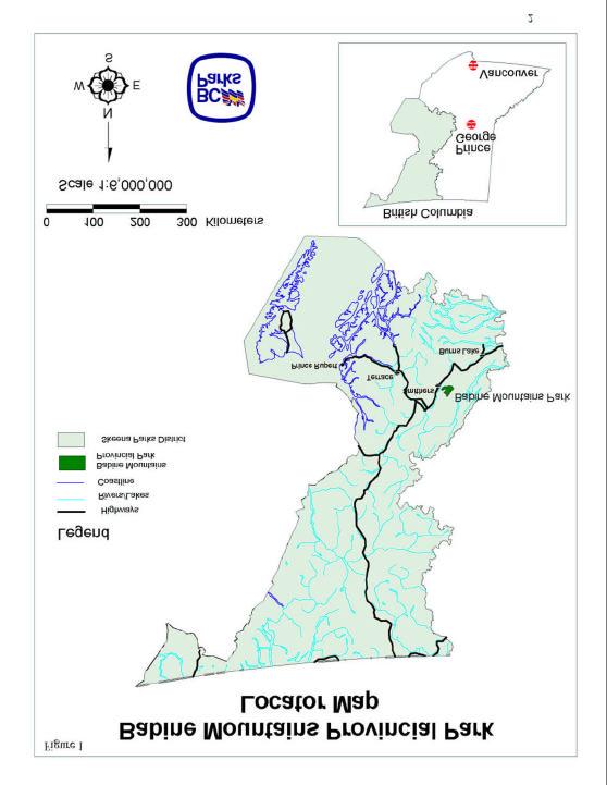
5 Introduction Purpose This management direction statement (MDS) provides management for the newly created extension to Babine Mountains Park. It identifies key strategies that will be ranked according to priority and completed as funding permits. All development associated with these strategies is subject to BC Parks' Impact Assessment Policy. Setting and Context Driftwood Extension covers 6,500 ha to the southwest of Babine Mountains Park. Driftwood Extension extends along a forested ridge between Driftwood and Reiseter creeks at elevations ranging from 900 to 1300 metres. The extension is bound by Reiseter Creek to the north, and mostly private land along the Telkwa High Road to the south. Babine Mountains Park lies 12-km northeast of Smithers, which has a population of about 12,000. (See Figures 1 and 2 for geographic description). The extension lies within the asserted traditional territory of the Wet suwet en people. The rolling forest habitat of Driftwood Extension complements Babine Mountains Park that is mostly rugged terrain dominated by subalpine forest and parkland and tundra, ranging from m in elevation. The entire area offers extensive backcountry recreational opportunities. Other parks near Smithers provide wilderness river recreation opportunities (Babine River Park) and full-facility camping facilities (Tyhee Lake Park). Several small parks, including Burnt Cabin Bog, Driftwood Canyon, etalzul Meadows and Waterfall protect a diversity of special natural features, Call Lake provides a range of day-use recreational activities and Rainbow Alley offers world -class trout fishing. Protected Area Attributes Conservation Southern Skeena Mountains Ecosection; SBSmc2 (moist cold sub -boreal spruce subzone, Babine variant) Saskatoon-slender wheatgrass scrub-steppe community above ewitt Creek (redlisted) subalpine meadows, shrub-carrs and fens, and south-facing aspen-dominated forests provide important spring to early winter range for moose and mule deer year-round habitat for grizzly and black bears and wolves Recreation and Tourism regionally-significant recreation opportunities (backcountry hiking, horseback riding, backcountry skiing, snowshoeing, snowmobiling, hunting) provides spring and fall hiking and horse riding opportunities, currently limited in the region due to late snowmelt and early snowfall 1
6 2
7 3
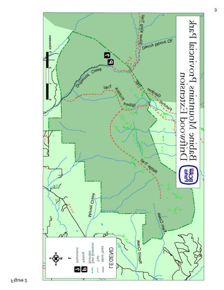
8 Cultural Heritage likely history of anthropogenic burning for berry production trail along ridge-top is likely of First ations origin other attributes not identified to BC Parks Significance in the Protected Areas System protects mid-elevation under-represented SBSmc2 within Southern Skeena Mountains Ecosection protects red-listed scrub-steppe community increases integrity of Babine Mountains Park by including mid-elevation forested recreation settings Land Uses, Tenures and Interests Access Main access route is via Driftwood Creek Road: in winter, the road is ploughed to a parking lot just outside the extension boundary; in summer, road access extends a further 6 km to a gate 1 km south of Sunny Point. More westerly access routes require permission from property owners to cross private land. Within the park extension, several skid roads have been used since the 1940 s by hikers and horseback riders as trails. Use has declined over time as brush has encroached. Such trails run north of Dieter and Adams Roads to Deer Meadows and Moose Meado ws. Snowmobile routes have been cleared and flagged and used for over 20 years: the Ridge Trail accesses a viewpoint about 7 km along Driftwood Hill, with short side spurs to Deer Meadows and Moose Meadows and return loop to Dieter Road; the Frohlick/Gilbert Trail forks off the Ridge Trail and extends 20 km to the Lower Harold Price Meadows (only the first 3.5 km is within the extension). A trail along the height of land is presumed to be a traditional First ations trail. Reiseter (Two-Bridge) Lake Trail, an old mineral exploration road, extends into the eastern portion of the extension, climbing out of Driftwood Creek drainage and dropping into Reiseter Creek drainage. This trail exits the park extension and passes through crown land for 4 km until entering Babine Mountains Park. Existing Tenures radio repeater site near ewitt Creek (Land Act Reserve ) two traplines within the extension one guide-outfitter operates within the extension Existing Land Use Activities and Facilities series of trails along old skid roads; First ations trails no other facilities exist use includes hiking, horseback riding, snowshoeing, cross-country ski-touring, snowmobiling by a few local residents, some hunting for bear and moose, access route to goat hunting in Babine Mountains 4
9 Adjacent Patterns of Land Use Babine Mountains Park, wilderness recreation zone, forms the northeast boundary Reiseter Creek special management zone (managed for water and visual quality low impact, low intensity logging practices) forms the north and west boundary private property, grazing leases (632132, ewitt Creek drainage; , 1 km west of boundary) and licenses (RA072843, 1 km west of boundary, RA072842, vacant) and a woodlot license (1506, Lyon Creek drainage) abut the south and southwest portion of the extension crown land, subject to integrated resource management, lies to the southeast First ations Interests part of the asserted traditional territory of the Wet suwet en Aboriginal Rights will be honoured and protected subject to conservation and safety concerns Wet suwet en staff have indicated the plan is acceptable to the Wet suwet en Chiefs following a review of the draft plan and a meeting with BC Parks staff. Other Agency Interests BC Environment has an interest in winter range for moose and deer and in ptarmigan wintering habitat in wetlands Ministry of Forests has a concern for tree health throughout the Bulkley Valley balsam bark beetle and mountain pine beetle occur in endemic levels through extension; numbers of pine in extension do not warrant excessive concern Ministry of Forests manages forestry and grazing activities on adjacent crown land Private and Public Stakeholder Interests recreational users: hikers, backcountry skiers, horseback riders, snowmobilers, hunters (Bulkley Valley Backpackers, Back Country Horsemen Society of BC, orthern Saddle Club, Smithers Snowmobiling Association, BV Rod and Gun Club, BC Wildlife Federation) local residents: Smithers and Telkwa communities, particularly park neighbours commercial users: trappers, guide-outfitter, Mountainview Trailriding Bulkley Valley aturalists, Sierra Club Role of Driftwood Extension Park Driftwood Extension Park serves important conservation and recreation roles in the British Columbia protected areas system. The extension protects about 3,000 ha of representative upland moist cold sub-boreal spruce (SBSmc2) ecosystems, including a red-listed shrub-steppe plant community. Protection of these upland ecosystems complements the narrow strip of riparian SBSmc2 forest in Babine River Corridor Park. Driftwood Extension Park s linkage to the adjacent subalpine and alpine ecosystems protected by Babine Mountains Park increases its conservation importance. Driftwood Extension Park is the primary backcountry recreation area close to Smithers, supporting high levels of regional use. It also provides a range of backcountry 5
10 opportunities including relatively accessible and safe backcountry day use and overnight use along informal trails, and winter access to more remote areas for backcountry skiing. Recreation management recognises traditional activities and use patterns for hiking, ski touring, horseback riding, hunting and snowmobiling. Management Commitments and Issues Direction from Previous Planning The Bulkley Valley LRMP recommended adding the Driftwood Extension to Babine Mountains Park in 1998, with the objective to protect the resources of this area for a wilderness recreation park as part of the Protected Areas system. The LRMP directs that ATV access be maintained on the existing road up to Harry Orm s cabin until a formal management plan is written for the protected area. Management Issues The following management issues require attention: Theme Issue Public safety area poses usual safety concerns for backcountry recreation in a wilderness environment Protecting ecological values inventory of natural features is incomplete status of red-listed ecosystems is unknown livestock may graze inside park boundary, with unknown impacts (red-listed scrub-steppe ecosystem is of particular concern) snowmobiles may impact ptarmigan populations in wetlands ATV use damages Driftwood Creek (existing foot bridge at Sunny Point is too narrow) Protecting recreational values history of use by local residents for hiking, skiing, horse riding, snowmobiling, hunting local residents travel through small section of extension on ATVs to reach Harry Orm s cabin brush encroachment limits accessibility of trails motorised winter use of unplowed Driftwood Road would conflict with historical nonmotorised use Protecting cultural values cultural features unknown 6
11 Management Strategy The following table describes management strategies to deal with outstanding issues raised. In addition, Appendix 1 contains a list of acceptable land and resource uses for this park. Priority Management Objectives Ensure Driftwood Extension is safe for public use Protect the park s natural values Protect the park s recreational values Priority Strategies Consider adopting BC Outdoor Recreation Council s code of ethics for trail use between use groups Identify safety issues of concern in consultation with local stakeholders Follow bear-people conflict prevention guidelines Inventory fauna and flora; prepare Ecology Information Summary Assess biotic integrity of red-listed e cosystems Assess potential issue of livestock grazing inside park boundary, particularly in the scrub-steppe ecosystems on south-facing slopes above ewitt Creek Develop ecologically appropriate beetle plan in conjunction with fire management plan; until then, do not manage balsam bark beetle, manage mountain pine beetle as necessary according to the Park Act (no harvesting), suppress wildfire Consider implementing Conservation Stewardship Program Upgrade bridge across Driftwood Creek at Sunny Point to allo w ATV crossing Limit ATV use to travelling 6km along Fletcher-Gardiner trail to Harry Orm s cabin for traditional use as recommended by LRMP/Community Resources Board; winter motorised use is not permitted on the Fletcher-Gardiner trail Complete backcountry recreation impact management studies on motorised trails Inventory and map trails and routes Allow snowmobiling along Ridge Trail and Gilbert -Frohick Trail; do not develop new routes; trail users are responsible for maintenance; trail improvements are prohibited; access is through private land permission for access must be given by land owners Review motorised use during Management Plan development, or earlier if necessary to protect the park s natural values. It is noted that forest development may provide alternative access to the Gilbert/Frohlick Trail to Harold Price Meadows for snowmobilers, and alternative ATV access to the Harry Orm cabin Prohibit motorized use on the Driftwood Road during winter months. Develop trail etiquette guidelines Monitor user group conflicts as preparation for Management Plan development Encourage the use of low impact camping equipment and techniques 7
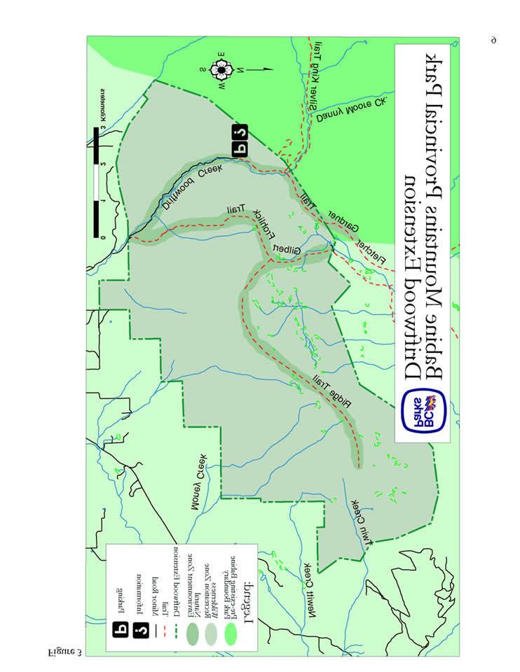
12 Priority Management Objectives Protect the park s cultural heritage values Develop appropriate facilities o facilities are anticipated Consultation and Future Planning Priority Strategies Investigate and collate existing information on cultural heritage values; prepare Cultural Features Information Summary in consultation with Wet suwet en Inventory logging history, mapping old mill sites and hauling trails The Bulkley LRMP directs current uses in the Driftwood Extension to continue until a full Management Plan is developed. When the Management Plan for Babine Mountains Park is reviewed, the Driftwood Extension will be incorporated. At that time, issues of access, recreational use and ecosystem management planning will be addressed for the entire area. In the interim, BC Parks will continue to work with adjacent landowners and the Community Resources Board to resolve immediate issues. BC Parks will continue to consult with Wet suwet en people about their use of the area and future site management actions. Preliminary Zoning The majority of the extension is zoned as Wilderness Recreation to promote a remote, undisturbed natural landscape and to provide backcountry recreation opportunities dependent on a pristine environment. The following trails are designated as natural environment: Driftwood Road as far as the parking lot/gate to accommodate motorized vehicles (not ATV s) during summer months. the first 6 km of the Fletcher-Gardiner Trail as far as Harry Orm s cabin to accommodate ATV use during summer months for traditional purposes Snowmobile use during winter months will be permitted along the Ridge Trail and the Gilbert-Frohlick Trail as an exception to the Wilderness Recreation Zone. 8
13 9
14 Appendix I Driftwood Extension Park - Table of Acceptable Activities, Uses and Facilities Activity/Use/Facility Acceptable Uses Aboriginal Rights Hunting Fishing Trapping Grazing (domestic livestock) Recreational gold panning/rock hounding Utility corridors Communication sites Horse use/pack animals Guide outfitting (hunting) Guide outfitting (fishing) Guide outfitting (nature tours) Guide outfitting (river rafting) Cat-assisted skiing Ski hills Commercial recreation (facility-based) Commercial recreation (non-facility-based) Backcountry huts Water control structures Fish stocking and enhancement Road access Off-road access (snowmobiling) 2 Off-road access (motorised) 2* Off-road access (mechanical activities) M Motorised water access Aircraft access 1 Fire management (suppression) Fire management (prescribed fire M management) Fire management (prevention) M Forest insect/disease control M oxious weed control Exotic insect/disease control 1 Scientific research (specimen collection) M Scientific research (manipulative activities) M = allowed subject to conditions identified in the management direction statement or management plan M = may be permitted if compatible with protected area objectives = not allowed 1 = allowed for expressed management purposes only 2 = present and allowed to continue, but not normally allowed * only as specified in management strategies 10
MANAGEMENT DIRECTION STATEMENT
 Skeena District MAAGEMET DIRECTIO STATEMET July, 2000 for Driftwood Canyon Provincial Park Ministry of Environment Lands and Parks BC Parks Division i Table of Contents Driftwood Canyon Park Approvals
MANAGEMENT DIRECTION STATEMENT March 2003
 Skeena Region MAAGEMET DIRECTIO STATEMET March 2003 for Meziadin Lake Provincial Park Ministry of Water, Land and Air Protection Environmental Stewardsh Division This page left blank on purpose ii Table
MANAGEMENT DIRECTION STATEMENT March 2003
 Skeena Region MAAGEMET DIRECTIO STATEMET March 2003 for Lava Forks Provincial Park Ministry of Water, Land and Air Protection Environmental Stewardshi Division This management direction statement was
MANAGEMENT DIRECTION STATEMENT June, 1999
 Thompson River District MANAGEMENT DIRECTION STATEMENT June, 1999 for Roche Lake Provincial Park Ministry of Environment Lands and Parks BC Parks Division Table of Contents I. Introduction A. Setting
MANAGEMENT DIRECTION STATEMENT
 Lower Mainland District MAAGEMET DIRECTIO STATEMET January 2001 for Liumchen Ecological Reserve Ministry of Environment Lands and Parks BC Parks Division Table of Contents Page Introduction... 1 Purpose
MANAGEMENT DIRECTION STATEMENT March 2003
 Skeena Region MAAGEMET DIRECTIO STATEMET March 2003 for Great Glacier Provincial Park Ministry of Water, Land an Air Protection Environmental Stewardship Division ii This management direction statement
MANAGEMENT DIRECTION STATEMENT June, 1999
 Thompson River District MANAGEMENT DIRECTION STATEMENT June, 1999 for Clearwater River Corridor (Addition to Wells Gray Park) Ministry of Environment Lands and Parks BC Parks Division ii Table of Contents
MANAGEMENT DIRECTION STATEMENT October, 1999
 Thompson River District MAAGEMET DIRECTIO STATEMET October, 1999 for Wire Cache Provincial Park Ministry of Environment Lands and Parks BC Parks Division Ministry of Environment, Lands and Parks BC Parks
MANAGEMENT DIRECTION STATEMENT November 2003
 Skeena Region MANAGEMENT DIRECTION STATEMENT November 2003 for Sutherland River Provincial Park and Sutherland River Protected Area Ministry of Water, Land and Air Protection Environmental Stewardship
As outlined in the Tatshenshini-Alsek Park Management Agreement, park management will:
 Management Strategy General Strategy The priority management focus for the park is to ensure that its internationally significant natural, cultural heritage and recreational values are protected and that
MANAGEMENT DIRECTION STATEMENT March 2003
 Skeena Region MAAGEMET DIRECTIO STATEMET March 2003 for Craig Headwaters Protected Area Ministry of Water, Land and Air Protection Environmental Stewardshi Division This management direction statement
MANAGEMENT DIRECTION STATEMENT February 2001
 Thompson River District MAAGEMET DIRECTIO STATEMET February 2001 for Greenstone Mountain Provincial Park Ministry of Environmen Lands and Parks BC Parks Division Table of Contents Introduction... 1 Purpose
MANAGEMENT DIRECTION STATEMENT June, 1999
 Garibaldi/Sunshine Coast District MAAGEMET DIRECTIO STATEMET June, 1999 for Homathko Estuary Provincial Park Ministry of Environment Lands and Parks BC Parks Division TABLE OF COTETS Introduction...1
MANAGEMENT DIRECTION STATEMENT October, 1999
 Thompson River District MAAGEMET DIRECTIO STATEMET October, 1999 for Chu Chua Cottonwood Provincial Park Ministry of Environment Lands and Parks BC Parks Division Ministry of Environment, Lands and Parks
Yard Creek Provincial Park. Management Plan
 Yard Creek Provincial Park Management Plan Draft January 2010 Yard Creek Provincial Park Management Plan Approved by: telàlsemkin/siyam/chief Scott Benton Bill Williams Squamish Executive Director ation
MANAGEMENT DIRECTION STATEMENT October, 1999
 Thompson River District MAAGEMET DIRECTIO STATEMET October, 1999 for Harry Lake Aspen Provincial Park Ministry of Environment Lands and Parks BC Parks Division Ministry of Environment, Lands and Parks
MANAGEMENT DIRECTION STATEMENT October, 1999
 Thompson River District MAAGEMET DIRECTIO STATEMET October, 1999 for orth Thompson Islands Provincial Park Ministry of Environment Lands and Parks BC Parks Division Ministry of Environment, Lands and Parks
Fred Antoine Park. Management Plan. Final Public Review Draft
 Fred Antoine Park Management Plan Final Public Review Draft March 2016 Fred Antoine Park Management Plan Approved by: Jeff Leahy Regional Director Thompson Cariboo Region BC Parks Date Brian Bawtinheimer
FINGER-TATUK PROVINCIAL PARK
 FINGER-TATUK PROVINCIAL PARK PURPOSE STATEMENT AND ZONING PLAN March 2003 FINGER-TATUK PROVINCIAL PARK Purpose Statement and Zoning Plan Finger-Tatuk Provincial Park is 17,151 ha in size. It includes the
MANAGEMENT DIRECTION STATEMENT March 2003
 Skeena Region MAAGEMET DIRECTIO STATEMET March 2003 for Lowe Inlet Marine Provincial Park Ministry of Water, Land and Air Protection Environmental Stewardshi Division This page left blank on purpose
D IRECTION S TATEMENT
 Vancouver Island Region M ANAGEMENT D IRECTION S TATEMENT September 2003 for Lower Nimpkish Provincial Park Ministry of Water, Land and Air Protection Environmental Stewardship Lower Nimpkish Provincial
SUGARBOWL-GRIZZLY DEN PROVINCIAL PARK AND SUGARBOWL-GRIZZLY DEN PROTECTED AREA Purpose Statement and Zoning Plan
 SUGARBOWL-GRIZZLY DEN PROVINCIAL PARK AND SUGARBOWL-GRIZZLY DEN PROTECTED AREA Purpose Statement and Zoning Plan Located one hour east of Prince George on Highway 16, Sugarbowl-Grizzly Den Provincial Park
OMINEACA PROVINCIAL PARK
 OMINEACA PROVINCIAL PARK AND PROTECTED AREA PURPOSE STATEMENT AND ZONING PLAN March 2003 OMINECA PROVINCIAL PARK AND PROTECTED AREA Purpose Statement and Zoning Plan Omineca Park and Omineca Protected
Stuart River Provincial Park Purpose Statement and Zoning Plan
 Stuart River Provincial Park Purpose Statement and Zoning Plan Stuart River Provincial Park protects three-quarters of the 110 kilometer long Stuart River corridor between Stuart Lake and the Nechako River.
2.0 PARK VISION AND ROLES
 2.0 PARK VISION AND ROLES 2.1 Significance in the Protected Area System Marble Range and Edge Hills provincial parks protect 6.8% of the Pavillion Ranges Ecosection, which is located in the Southern Interior
Kwadacha Wilderness Provincial Park and Kwadacha Addition (Kwadacha Recreation Area) Purpose Statement and Zoning Plan
 Purpose Statement and Zoning Plan") Kwadacha Wilderness Provincial Park and Kwadacha Addition (Kwadacha Recreation Area) Purpose Statement and Zoning Plan Located in a remote area of the northern interior of BC, this large park straddles
Kwadacha Wilderness Provincial Park and Kwadacha Addition (Kwadacha Recreation Area) Purpose Statement and Zoning Plan Located in a remote area of the northern interior of BC, this large park straddles
MANAGEMENT DIRECTION STATEMENT November 1999
 Garibaldi/Sunshine Coast District MAAGEMET DIRECTIO STATEMET ovember 1999 for Upper Lillooet Provincial Park Ministry of Environment Lands and Parks BC Parks Division UPPER LILLOOET PROVICIAL PARK APPROVALS
STONE MOUNTAIN PROVINCIAL PARK Purpose Statement and Zoning Plan
 1 STONE MOUNTAIN PROVINCIAL PARK Purpose Statement and Zoning Plan Stone Mountain Provincial Park is situated 140 km west of Fort Nelson at Kilometre 595 of the Alaska Highway. The 25 690 ha park is located
Role of the Protected Area
 Role of the Protected Area Provincial and Regional Context Height of the Rockies and Elk Lakes provincial parks lie in southeastern British Columbia in the Rocky Mountains, about 85 km southwest of Calgary,
Outdoor Recreation Opportunities Management
 Outdoor Recreation Opportunities Management Introduction The natural features of Height of the Rockies and Elk Lakes provincial parks provide a wide variety of outdoor recreational activities. However,
Peace Region. MANAGEMENT Plan. January for Toad River Hot Springs Provincial Park. Ministry of Environment. Environmental Stewardship Division
 Peace Region MANAGEMENT Plan January 2009 for Toad River Hot Springs Provincial Park Ministry of Environment Environmental Stewardship Division Toad River Hot Springs Park Approvals Page Forward This management
Restore and implement protected status that is equivalent, or better than what was lost during the mid-1990 s
 THE ROSSLAND RANGE, OLD GLORY AREA. Executive summary. The Friends of the Rossland Range Society, on behalf of the local outdoor community, seeks to accomplish the following with respect to the Old Glory
ANAGEMENT P LAN. February, for Elk Lakes and Height of the Rockies Provincial Parks. Ministry of Environment, Lands and Parks BC Parks Division
 M ANAGEMENT P LAN February, 1999 for Elk Lakes and Height of the Rockies Provincial Parks Ministry of Environment, Lands and Parks BC Parks Division Elk Lakes & Height of the Rockies Provincial Parks M
5.0 OUTDOOR RECREATION OPPORTUNITIES AND MANAGEMENT
 5.0 OUTDOOR RECREATION OPPORTUNITIES AND MANAGEMENT 5.1 Introduction This section describes the range of recreational activities that currently take place in Marble Range and Edge Hills Parks, as well
Bridge River Delta Park. Management Plan. Final Public Review Draft
 Bridge River Delta Park Management Plan Final Public Review Draft March 2016 Bridge River Delta Park Management Plan Approved by: Jeff Leahy Regional Director Thompson Cariboo Region BC Parks Date Brian
Dragon Mountain Park. Management Plan. Public Review Draft
 Disclaimer: This draft management plan contains preliminary proposals that are subject to change and therefore may not necessarily reflect the position of the Ministry of Environment. At the conclusion
Dragon Mountain Park. Management Plan
 Dragon Mountain Park Management Plan December 2015 Dragon Mountain Park Management Plan Approved by: Peter Weilandt A/Regional Director Thompson Cariboo Region BC Parks December 14. 2015 Date Brian Bawtinheimer
Fraser River Provincial Park Purpose Statement and Zoning Plan
 Fraser River Provincial Park Purpose Statement and Zoning Plan Fraser River Provincial Park is located on the west bank of the Fraser River, approximately 35 km south of Prince George. This 4,899 ha Protected
Appendix A BC Provincial Parks System Goals
 Appendix A BC Provincial Parks System Goals The British Columbia Provincial Parks System has two mandates: To conserve significant and representative natural and cultural resources To provide a wide variety
Marchand Provincial Park. Management Plan
 Marchand Provincial Park Management Plan 2 Marchand Provincial Park Table of Contents 1. Introduction... 3 2. Park History... 3 3. Park Attributes... 4 3.1 Natural... 4 3.2 Recreational... 4 3.3 Additional
Sand Lakes Provincial Park. Draft Management Plan
 Sand Lakes Provincial Park Draft Management Plan 2 Sand Lakes Provincial Park Table of Contents 1. Introduction... 3 2. Background... 3 3. Park Purpose... 5 4. Park Management Guidelines... 6 Appendix...
Mackinnon Esker Ecological Reserve Draft - Management Plan
 Mackinnon Esker Ecological Reserve Draft - Management Plan May 2011 Photo Credit: This document replaces the direction provided in the Carp Lake Provincial Park and Protected Area and Mackinnon Esker Ecological
Muscovite Lakes Provincial Park Purpose Statement and Zoning Plan
 Muscovite Lakes Provincial Park Purpose Statement and Zoning Plan Muscovite Lakes Provincial Park is a 5,708-hectare park located on the western shore of Williston Reservoir, approximately 135 kilometres
Seager Wheeler Lake. Representative Area. -- Concept Management Plan --
 Seager Wheeler Lake Representative Area -- Concept Management Plan -- Saskatchewan Environment and Resource Management January, 1999 Saskatchewan s Representative Areas Network Program The Government of
Pillar Park. Management Plan
 Pillar Park Management Plan January 2014 Pillar Park Management Plan Approved by: Jeff Leahy Regional Director Thompson Cariboo Region BC Parks January 9, 2014 Date Brian Bawtinheimer Executive Director
MILLIGAN HILLS PROVINCIAL PARK
 MILLIGAN HILLS PROVINCIAL PARK PURPOSE STATEMENT AND ZONING PLAN Peace Region 2006 Approved by: Andy Ackerman, Regional Manager Environmental Stewardship Division Peace Region Date: 2006 Nancy Wilkin Assistant
MANAGEMENT DIRECTION STATEMENT November, 1999
 Cariboo District AAGEET DIRECTIO STATEET ovember, 1999 for Big Creek Provincial Park inistry of Environment Lands and Parks BC Parks Division Big Creek ountains Provincial Park Approvals Page Forward The
HOLE IN THE WALL PROVINCIAL PARK
 HOLE IN THE WALL PROVINCIAL PARK PURPOSE STATEMENT AND ZONING PLAN Peace Region 2006 Approved by: Andy Ackerman, Regional Manager Environmental Stewardship Division Peace Region Date: 2006 Nancy Wilkin
Clearwater Lake Provincial Park. Draft Management Plan
 Clearwater Lake Provincial Park Draft Management Plan Clearwater Lake Provincial Park Draft Management Plan Table of Contents 1. Introduction... 3 2. Park History... 4 3. Park Attributes... 4 3.1 Location/Access...4
White Lake Peatlands. Interim Management Statement
 White Lake Peatlands Interim Management Statement 2007 APPROVAL STATEMENT I am pleased to approve this Interim Management Statement for White Lake Peatlands Provincial Park. This park was regulated under
Appendix A Chilko Lake Protected Area Intent and Management Principles
 Appendix A Chilko Lake Protected Area Intent and Management Principles 95 Intent and Management Principles (as prescribed by the Chilko Lake Study Team) General Intent This proposed Chilko Lake Protected
Approval Statement. Brian Pfrimmer, Central Zone Manager Ontario Parks
 Approval Statement I am pleased to approve this Interim Management Statement for Dividing Lake Provincial Nature Reserve. This Nature Reserve contains biological features of provincial significance and
Wallace Lake Provincial Park. Management Plan
 Wallace Lake Provincial Park Management Plan 2 Wallace Lake Provincial Park Table of Contents 1. Introduction... 3 2. Park History... 3 3. Park Attributes... 4 3.1 Natural... 4 3.2 Recreational... 4 4.
D IRECTION S TATEMENT
 Vancouver Island Region M AAGEMET D IRECTIO S TATEMET September 2003 for Woss Lake Provincial Park Ministry of Water, Land an Air Protection Environmental Stewardship Division Woss Lake Provincial Park
Draft Concept Plan. for the. Proposed Saskatoon Mountain Provincial Recreation Area
 Draft Concept Plan for the Proposed Saskatoon Mountain Provincial Recreation Area April 2014 Table of Contents INTRODUCTION... PROPOSAL SUMMARY... 1.0 DESCRIPTION OF THE PROPOSED SASKATOON MOUNTAIN PROVINCIAL
SLIM CREEK PROVINCIAL PARK
 SLIM CREEK PROVINCIAL PARK PURPOSE STATEMENT AND ZONING PLAN March 2003 1 Slim Creek Provincial Park Purpose Statement and Zoning Plan Slim Creek Provincial Park is located along Highway 16, approximately
Steps in the Management Planning Process
 Steps in the Management Planning Process Developing a management plan for Kalamalka Lake Park will follow a multi-stage process. The planning process for this park is currently in the Draft Management
Wallace Lake Provincial Park. Draft Management Plan
 Wallace Lake Provincial Park Draft Management Plan Wallace Lake Provincial Park Draft Management Plan Table of Contents 1. Introduction... 3 2. Park History... 3 3. Park Attributes... 4 3.1 Natural...
Qwalímak/Upper Birkenhead Conservancy. Management Plan
 Qwalímak/Upper Birkenhead Conservancy Management Plan March 2012 Cover photo: Upper Birkenhead River Photo credit: Liz Scroggins Qwalímak/Upper Birkenhead Conservancy Management Plan Acknowledgements
ARCTIC PACIFIC LAKES PROVINCIAL PARK
 ARCTIC PACIFIC LAKES PROVINCIAL PARK PURPOSE STATEMENT AND ZONING PLAN March 2003 ARCTIC PACIFIC LAKES PROVINCIAL PARK Purpose Statement and Zoning Plan Located 90 km northeast of Prince George in the
Nenikëkh/Nanika-Kidprice Park. Management Plan
 enikëkh/anika-kidprice Park Management Plan September 2010 Cover photo D. Cichowski. enikëkh/anika-kidprice Park Management Plan Approved by: Scott Benton Executive Director Parks and Protected Areas Division
TAYLOR CANYON RANCH COLORADO - ROUTT COUNTY - STEAMBOAT SPRINGS
 TAYLOR CANYON RANCH COLORADO - ROUTT COUNTY - STEAMBOAT SPRINGS Tucked up against the steep valley shaped by Mt. Pau and rising to the Routt National Forest, Taylor Canyon Ranch is an easily accessible,
ANAGEMENT P LAN. July for Chilliwack Lake Park & Chilliwack River Ecological Reserve. Ministry of Environment, Lands and Parks BC Parks Division
 M ANAGEMENT P LAN July 2000 for Chilliwack Lake Park & Chilliwack River Ecological Reserve Ministry of Environment, Lands and Parks BC Parks Division Chilliwack Lake Provincial Park & Chilliwack River
Summer Recreational Access Management Plan For the Bulkley LRMP Draft Report: June 2012
 Summer Recreational Access Management Plan For the Bulkley LRMP Draft Report: June 2012 Prepared by Summer RAMP Table Submitted to Bulkley Valley Community Resources Board June 2012 Facilitator Tom Chamberlin
NECHAKO CANYON PROTECTED AREA
 NECHAKO CANYON PROTECTED AREA PURPOSE STATEMENT AND ZONING PLAN March 2003 1 Nechako Canyon Protected Area Purpose Statement and Zoning Plan The Nechako Canyon Protected Area (1,246 hectares) is located
MARBLE RIVER PROVINCIAL PARK
 MARBLE RIVER PROVINCIAL PARK PURPOSE STATEMENT AND ZONING PLAN March 2003 MARBLE RIVER PROVINCIAL PARK Purpose Statement and Zoning Plan Primary Role The primary role of Marble River Park is to protect
HEATHER-DINA LAKES PROVINCIAL PARK
 HEATHER-DINA LAKES PROVINCIAL PARK PURPOSE STATEMENT AND ZONING PLAN March 2003 HEATHER-DINA LAKES PROVINCIAL PARK Purpose Statement and Zoning Plan Heather-Dina Lakes Provincial Park is located 25 km
ONE ISLAND LAKE PROVINCIAL PARK Purpose Statement and Zoning Plan
 ONE ISLAND LAKE PROVINCIAL PARK Purpose Statement and Zoning Plan Primary Role The primary role of One Island Lake Provincial Park is to provide recreational opportunities to regional and residential area
South Atikaki Provincial Park. Draft Management Plan
 South Atikaki Provincial Park Draft Management Plan South Atikaki Provincial Park Draft Management Plan Table of Contents 1. Introduction... 3 2. Park History... 3 3. Park Attributes... 3 3.1 Natural...
CARMANAH WALBRAN PROVINCIAL PARK
 CARMANAH WALBRAN PROVINCIAL PARK PURPOSE STATEMENT AND ZONING PLAN September 2003 1 CARMANAH WALBRAN PROVINCIAL PARK Purpose Statement and Zoning Plan Carmanah Walbran Provincial Park is an expansion of
July Old Man Lake Park Management Plan
 July 2010 Old Man Lake Park Management Plan Cover photo D. Cichowski. Old Man Lake Park Management Plan Approved by: Scott Benton Executive Director Parks and Protected Areas Division May 7 th, 2010 Date
South Chilcotin Mountains Park and Big Creek Park. Management Plan. Final Public Review Draft
 South Chilcotin Mountains Park and Big Creek Park Management Plan Final Public Review Draft March 2016 This document replaces the Big Creek Park Management Direction Statement, approved in November 1999.
September Morice Lake Park Management Plan
 September 2010 Morice Lake Park Management Plan Cover photo M. Parminter, BC Parks. Morice Lake Park Management Plan Approved by: Scott Benton Executive Director Parks and Protected Areas Division May
April 10, Mark Stiles San Juan Public Lands Center Manager 15 Burnett Court Durango, CO Dear Mark,
 Mark Stiles San Juan Public Lands Center Manager 15 Burnett Court Durango, CO 81301 Dear Mark, We are pleased to offer the following comments on the draft San Juan Public Lands Center management plans
KANANASKIS COUNTRY PROVINCIAL RECREATION AREAS MANAGEMENT PLAN DRAFT TERMS OF REFERENCE - November 20, 2007
 KANANASKIS COUNTRY PROVINCIAL RECREATION AREAS MANAGEMENT PLAN DRAFT TERMS OF REFERENCE - November 20, 2007 BACKGROUND There are 42 Provincial Recreation Areas (PRAs) within Kananaskis Country located
ANAGEMENT. LAN November, 1996
 M ANAGEMENT P LAN November, 1996 for Paul Lake Provincial Park Ministry of Environment, Lands and Parks BC Parks Department Paul Lake Provincial Park M ANAGEMENT P LAN Prepared by BC Parks Kamloops Area
PROUDLY BRINGING YOU CANADA AT ITS BEST. Management Planning Program NEWSLETTER #1 OCTOBER, 2000
 PROUDLY BRINGING YOU CANADA AT ITS BEST VUNTUT NATIONAL PARK Management Planning Program NEWSLETTER #1 OCTOBER, 2000 INTRODUCTION This newsletter launches the development of the first management plan for
Mackinnon Esker Ecological Reserve. Management Plan
 Mackinnon Esker Ecological Reserve Management Plan March 2017 Cover Page Photo Credit: Rob Bell This document replaces the direction provided in the Carp Lake Provincial Park and Protected Area and Mackinnon
Longlac North Conservation Reserve (C2207) Statement of Conservation Interest
 Statement of Conservation Interest") Longlac North Conservation Reserve (C2207) Statement of Conservation Interest April 2003 Prepared for the Ontario Ministry of Natural Resources, Northwest Region by Rebecca Zeran and Natalie Kolody OLL
Longlac North Conservation Reserve (C2207) Statement of Conservation Interest April 2003 Prepared for the Ontario Ministry of Natural Resources, Northwest Region by Rebecca Zeran and Natalie Kolody OLL
Non-motorized Trail Plan & Proposal. August 8, 2014
 Town of Star Valley Ranch, Wyoming and the Star Valley Ranch Association in partnership with the USDA Forest Service, Bridger-Teton National Forest, Greys River Ranger District Non-motorized Trail Plan
Skihist Park. Management Plan. Draft for public review
 Skihist Park Management Plan Draft for public review August 2017 This document replaces the Skihist Park Management Plan (November 1996). Skihist Park Management Plan Approved by: Jeff Leahy Regional Director
APPENDIX. Alberta Land Stewardship Act AMENDMENTS TO THE SOUTH SASKATCHEWAN REGIONAL PLAN
 APPENDIX Alberta Land Stewardship Act AMENDMENTS TO THE SOUTH SASKATCHEWAN REGIONAL PLAN 1 All references to Alberta Environment and Sustainable Resource Development, Environment and Sustainable Resource
Summer Recreational Access Management Plan For the Bulkley LRMP
 Summer Recreational Access Management Plan For the Bulkley LRMP Prepared by Summer RAMP Table Submitted to Bulkley Valley Community Resources Board February 2013 Facilitator Tom Chamberlin Funding provided
FINAL TESTIMONY 1 COMMITTEE ON RESOURCES UNITED STATES HOUSE OF REPRESENTATIVES. July 13, 2005 CONCERNING. Motorized Recreational Use of Federal Lands
 FINAL TESTIMONY 1 STATEMENT OF DALE BOSWORTH CHIEF Of the FOREST SERVICE UNITED STATES DEPARTMENT OF AGRICULTURE Before the SUBCOMMITTEE ON FORESTS AND FOREST HEALTH And the SUBCOMMITTEE ON NATIONAL PARKS,
BIGHORN BACKCOUNTRY ACCESS MANAGEMENT PLAN
 BIGHORN BACKCOUNTRY ACCESS MANAGEMENT PLAN October, 2002 SPECTACULAR BY NATURE BIGHORN BACKCOUNTRY Alberta s Bighorn Backcountry offers spectacular Rocky Mountain scenery and unforgettable recreational
Numaykoos Lake Provincial Park. Management Plan
 Numaykoos Lake Provincial Park Management Plan 2 Numaykoos Lake Provincial Park Table of Contents 1. Introduction... 3 2. Background... 3 3. Park Purpose... 5 4. Park Management Guidelines... 6 Appendix...
Disclosure Document for Castle Mountain Resort Future Development
 Disclosure Document for Castle Mountain Resort Future Development September 2018 1._ Introduction Castle Mountain Resort Inc. (CMR) has completed a Master Development Plan that proposes to expand the existing
Nadina Mountain Park Management Plan
 adina Mountain Park Management Plan Draft October 2009 ** A Wet suwet en name for the park is currently being developed and will be added when it is finalized ** Prepared by: Skeena Region Parks and Protected
The following criteria were used to identify Benchmark Areas:
 7.0 BENCHMARK AREAS The Churn Creek Protected Area offers a significant opportunity to learn more about how grassland ecosystems function. One of the key tools that will be used to monitor larger grassland
Monkman Provincial Park. Master Plan
 Monkman Provincial Park Master Plan Table of Contents Plan Highlights...1 Section One: Introduction What is a Master Plan?...4 Relationship With Other Land Use Planning...6 How This Plan Was Prepared...7
Boyne Valley Provincial Park. Interim Management Statement
 Boyne Valley Provincial Park Interim Management Statement January 20, 1995 REGIONAL DIRECTOR'S APPROVAL STATEMENT This Interim Management Statement will provide interim direction for the management of
Bulkley Canyon Farms Ltd. Smithers B.C.
 Remax Bulkley Valley Charlie McClary 8462 Johnson Road, Smithers, BC, V0J 2N1 Email cmcclary@uniserve.com (250) 877-1770 Cell (250) 847-5999 Office www.charliemcclary.com Bulkley Canyon Farms Ltd. Smithers
VARGAS ISLAND PROVINCIAL PARK
 VARGAS ISLAND PROVINCIAL PARK PURPOSE STATEMENT AND ZONING PLAN February 2003 VARGAS ISLAND PROVINCIAL PARK Purpose Statement and Zoning Plan Primary Role The primary role of Vargas Island Park is to protect
Watchorn Provincial Park. Management Plan
 Watchorn Provincial Park Management Plan 2 Watchorn Provincial Park Table of Contents 1. Introduction... 3 2. Park History... 3 3. Park Attributes... 3 3.1 Natural... 4 3.2 Recreational... 4 3.3 Additional
Invest in Waterfront Property
 Invest in Waterfront Property Day Lake $599,000 Total Acreage: 465 acres Private lakefront parcel located in North-Central BC Private Lakefront Retreat www.niho.com (604) 606-7900 Private Lakefront Retreat!
Ranch. Creek. Cow. Mountain
 Cow Creek Mountain Ranch Situated along the southwestern hills of the Laramie Mountains and the Medicine Bow-Routt National Forest in northeastern Albany County, Wyoming. 58 E. Benteen Street Buffalo,
Whitemouth Falls Provincial Park. Draft Management Plan
 Whitemouth Falls Provincial Park Draft Management Plan Whitemouth Falls Provincial Park Draft Management Plan Table of Contents 1. Introduction... 3 2. Park History... 3 3. Park Attributes... 4 3.1 Natural...
CATHEDRAL PROVINCIAL PARK MASTER PLAN
 CATHEDRAL PROVINCIAL PARK MASTER PLAN JUNE, 1989 TABLE OF CONTENTS A. Plan Highlights 1 B. Introduction 2 1. Purpose of the Plan 2 2. Planning Issues 3 3. Background Summary 6 C. The Role of the Park 9
KOOTENAY LAKE PROVINCIAL PARK (MIDGE CREEK SITE)
") KOOTENAY LAKE PROVINCIAL PARK (MIDGE CREEK SITE) PURPOSE STATEMENT AND ZONING PLAN February 2003 Approved by: KOOTENAY LAKE PROVINCIAL PARK (Midge Creek Site) Purpose Statement and Zoning Plan Primary
KOOTENAY LAKE PROVINCIAL PARK (MIDGE CREEK SITE) PURPOSE STATEMENT AND ZONING PLAN February 2003 Approved by: KOOTENAY LAKE PROVINCIAL PARK (Midge Creek Site) Purpose Statement and Zoning Plan Primary
Telkwa Mountains Recreation Access Management Advisory Group
 Telkwa Mountains Recreation Access Management Advisory Group Meeting minutes,, 2016. Meeting convened at 5:30 PM, Round Lake Hall, Telkwa, B. C. Attendance/Representation: ATVers - Dave Tolton Ed Hinchliffe