Qwalímak/Upper Birkenhead Conservancy. Management Plan
|
|
|
- Tamsyn Lambert
- 5 years ago
- Views:
Transcription

1 Qwalímak/Upper Birkenhead Conservancy Management Plan March 2012
2 Cover photo: Upper Birkenhead River Photo credit: Liz Scroggins
3 Qwalímak/Upper Birkenhead Conservancy Management Plan
4
5 Acknowledgements The Lil wat Nation and BC Parks have jointly prepared this management plan. The management planning process was coordinated by Harriet VanWart, Referral Coordinator, and Lucinda Phillips, Director, Land and Resources Department of the Lil wat Nation and by Vicki Haberl, Planning Section Head, South Coast Region, BC Parks. Tracy Howlett, GIS Manager for the Lil wat Nation Land and Resources Department, prepared all of the maps. Liz Scroggins of Scroggins Consulting prepared management plan drafts for review by Lil wat Nation and BC Parks, under contract to Lil wat Nation. The management planning team extends special thanks to Johnny Jones and Lex Joseph of the Lil wat Nation for their input on culturally significant features and for their review of the management plan documents. Additional thanks are also extended to Jennie Aikman, Regional Planner for BC Parks, for providing support to the management planning process. The Lil wat Nation and Ministry of Environment would like to thank those who took the time to provide comments on this conservancy management plan. Qwalímak/Upper Birkenhead Conservancy Management Plan i
6 Table of Contents Acknowledgements... i 1.0 Introduction Management Plan Purpose Planning Area Legislative Framework Management Commitments Adjacent Land Use Planning Process Values and Roles of the Conservancy Significance in the Protected Areas System Cultural Heritage Natural Heritage Recreation Development and Use of Natural Resources Management Direction Vision Management Objectives, Issues and Strategies Zoning Plan Implementation Policy Context Implementation Implementation Priorities Appendix 1: Appropriate Uses Table Appendix 2: Biogeoclimatic Zones Figure 1: Regional Context Map... 2 Figure 2: Qwalímak/Upper Birkenhead Conservancy Map... 3 Figure 3: Adjacent Land Use Map... 7 Figure 4: Natural Features Figure 5: Biogeoclimatic Zone Map Qwalímak/Upper Birkenhead Conservancy Management Plan ii
7 1.0 Introduction The Qwalímak/Upper Birkenhead Conservancy (the conservancy) is located in the headwaters of the culturally and ecologically rich Birkenhead River watershed. The Lil wat Nation has named the area Qwalímak, a word meaning mosquito in the Ucwalmicwts language. 1.1 Management Plan Purpose The purpose of this management plan is to guide the management of the conservancy. The management plan: describes the background and legal context of the conservancy; sets out a vision and role for the conservancy; identifies significant conservancy features; identifies management issues, objectives and strategies; and, identifies zones in the conservancy where area specific management direction applies. 1.2 Planning Area The conservancy is located in the Lil wat Nation Traditional Territory (Lil wat Territory), approximately 60 kilometres north of Pemberton and Mount Currie (Figure 1). The conservancy is approximately 4,888 hectares in size and encompasses the uppermost reaches of the Birkenhead River watershed. From its origins in the conservancy, the Birkenhead River flows for approximately 60 kilometres through the Coast Mountains into the north end of Lillooet Lake. The main access to the conservancy is via the Birkenhead River Forest Service Road which is located off of the Pemberton-D Arcy Portage Road, approximately 35 kilometres northeast from Pemberton. The northern portion of the conservancy can be accessed by travelling from the Hurley River Road, along the Hope Creek Forest Service Road, and then traversing in by foot from the road (Figure 2). The conservancy is adjacent to the western boundary of Birkenhead Lake Park. Qwalímak/Upper Birkenhead Conservancy Management Plan 1

8 Figure 1: Regional Context Map Qwalímak/Upper Birkenhead Conservancy Management Plan 2

9 Figure 2: Qwalímak/Upper Birkenhead Conservancy Map Qwalímak/Upper Birkenhead Conservancy Management Plan 3
10 1.3 Legislative Framework The Qwalímak/Upper Birkenhead Conservancy was established on June 27, 2008 and is named and described in Schedule E of the Protected Areas of British Columbia Act. A conservancy is set aside for four reasons: (a) (b) (c) (d) the protection and maintenance of their biological diversity and natural environments; the preservation and maintenance of social, ceremonial and cultural uses of first nations; the protection and maintenance of their recreation values; and to ensure that development or use of their natural resources occurs in a sustainable manner consistent with the purposes of paragraphs (a), (b) and(c). Under the Park Act commercial logging, mining, and hydro electric power generation (other than local run-of-the-river projects) are not permitted in conservancies. "Local run-of-the-river projects" in relation to a conservancy, means hydro power projects supplying power for use (a) in the conservancy, or (b) by communities, including first nation communities, that do not otherwise have access to hydro electric power. 1.4 Management Commitments In 2006 the Lil wat Nation developed the Lil wat Land Use Plan: Phase 1 which presented the vision and plan for the land and resources of the Lil wat Territory. In April 2008, the Sea to Sky Land and Resource Management Plan was completed. This plan provides direction for future land use planning and management of natural resources in the Sea to Sky area. That same month, a Land Use Planning Agreement between the Lil wat Nation and the Province of British Columbia (LUPA) was signed by Lil wat Nation and the Province. Under the Land Use Planning Agreement, the Province agreed to establish new protected areas, including the Qwalímak/Upper Birkenhead Conservancy. The Province also committed to prepare a management plan for the conservancy once it was established. The Lil wat Land Use Plan, Sea-to-Sky Land and Resource Management Plan and the Land Use Planning Agreement provide high-level direction for land use in the conservancy and on adjacent lands. The Land Use Planning Agreement 1 sets out high-level management direction and objectives for the conservancy: to maintain opportunities for Lil wat Nation social, ceremonial and cultural uses; to protect and enhance the integrity of the Lil wat Nation s cultural and heritage resources, including sacred sites; 1 Land Use Planning Agreement between the Lil wat Nation and the Province of British Columbia (2008). Section C- 4 Management Direction. Qwalímak/Upper Birkenhead Conservancy Management Plan 4
11 to protect the biological diversity and natural environments, including wildlife habitat values and low elevation riparian ecosystems; to maintain, where appropriate, current levels of low intensity backcountry recreational and tourism uses; and, to increase opportunities for Lil wat Nation participation in commercial recreation and tourism enterprises. Section 5.5 of the Land Use Planning Agreement states that all tenures in the conservancy will be reviewed to determine if existing tenures should be authorized by park use permits and whether or not any tenure amendments are required to meet the management intent of the conservancy. This management plan and the Lil wat Nation s involvement in the development of this management plan are without prejudice to the aboriginal rights, including aboriginal title, of the Lil wat Nation. Nothing in this management plan is intended to create, define, diminish, alter, abrogate or extinguish Lil wat Nation aboriginal rights, including aboriginal title. 1.5 Adjacent Land Use Forestry The lower portion of the conservancy is bordered by the Soo Timber Supply Area (TSA). Mining Tenures Mineral exploration has been ongoing in this area for many years. There are many old mine workings and evidence of exploration in the surrounding area. There are six active mineral tenures adjacent to the western boundary of the conservancy; none of these tenures overlap the conservancy. Recreation There is a licence for commercial recreation (land file ) held by Chilcotin Holidays Inc. which overlaps the uppermost portions of the conservancy. There is also a licence for commercial heli-skiing (land file ) held by Whistler Heli-Skiing Ltd. which overlaps most of the conservancy; this term extends until Hiking and mountain biking occur in the nearby Tenquille Lake area which can be accessed by the Birkenhead Forest Service Road, at the southern end of the conservancy (Figure 3). Active forest service roads including Hope Creek Forest Service Road (ID ) and East Hope Creek Forest Service Road (ID ) are located in the Hope Creek drainage, the watershed to the north of the conservancy. These forest service roads may enable limited access to the upper conservancy. Cat-skiing and snowmobiling take place in the Hope Creek area, but is not believed to Qwalímak/Upper Birkenhead Conservancy Management Plan 5
12 be occurring in the conservancy, although motorised access to the conservancy via these Forest Service Roads is a management concern (Figure 3). Adjacent to the conservancy, to the east, Birkenhead Lake Park offers recreational opportunities, some of which are supported with developed facilities including campgrounds and picnic sites. Although the two protected areas connect at the height of land, access to Birkenhead Lake Park is via the Blackwater Creek Forest Service Road, while access to Qwalímak/Upper Birkenhead Conservancy is accessed via the Birkenhead River Forest Service Road (Figure 1). Sea-to Sky Land and Resource Management Plan Zoning Lands adjacent to the conservancy have been designated as Wildland Zones and a Cultural Management Area under the Sea-to-Sky Land and Resource Management Plan (S2S LRMP) (Figure 3). Wildland Zones are identified under the Sea-to-Sky Land and Resource Management Plan to recognize areas with First Nations cultural values, high wildlife values, backcountry recreation values, and remote wilderness characteristics (S2S LRMP, p. ii). The Qwalímak/Birkenhead Headwaters Wildland Zone (#6) encompasses the headwaters of the Birkenhead River watershed to the west and southeast of the conservancy. Area-specific management direction for this cultural Wildland Zone encourages commercial and public recreation facilities to be located outside of the Wildland Zone. Facilities may be considered where they do not interfere with First Nation uses. The Sockeye Creek Headwaters Wildland Zone (# 38) encompasses the Sockeye Creek watershed to the northeast of the conservancy. The management direction for this wildlife Wildland Zone is to minimize impacts to Mountain Goat, Bull Trout, Wolverine and Grizzly Bear. This area provides high value summer forage habitat for Grizzly Bears. Commercial or public lodges are not permitted in this zone (p.185, S2S LRMP). The Qwalímak/Birkenhead River Cultural Management Area is adjacent to the lower sections of the conservancy, and is divided into two units: the Birkenhead River Upland and the Birkenhead River Corridor. Construction of new cabins and lodges is not permitted in the Cultural Management Area unless it can be demonstrated that any construction is consistent with cultural use of the area through consultation with First Nations (p. 93, S2S LRMP). Qwalímak/Upper Birkenhead Conservancy Management Plan 6

13 Figure 3: Adjacent Land Use Map Qwalímak/Upper Birkenhead Conservancy Management Plan 7
14 Protected Areas Most of the eastern portion of the conservancy is bordered by Birkenhead Lake Park. The management plan for Birkenhead Lake Park identifies the portion of the park adjacent to the conservancy as a Wilderness Conservation Zone to protect the remote wilderness landscape. Other Tenures There are two trapline licence areas overlapping the conservancy (ID#TR0211T008 and ID# TR0211T005). 1.6 Planning Process BC Parks and Lil wat Nation worked collaboratively to develop management plans for three conservancies in the Lil wat Nation s traditional territory: K zuzált/twin Two Conservancy, Mkwal ts Conservancy and Qwalímak/Upper Birkenhead Conservancy. The planning team developed a Terms of Reference which has guided the conservancy management planning process. Liz Scroggins of Scroggins Consulting prepared the draft management plans with input from Lil wat Nation and BC Parks representatives, and together, all three parties made up the planning team. Data gathering and draft management plan preparations were followed by a collaborative review process from the management planning team. Both Lil wat Nation and BC Parks conducted an initial internal review of the plans. A public review period was initiated with two open house events, one in Mt. Currie and one in Pemberton. The draft management plans were posted on the BC Parks website and comments were submitted to Vicki Haberl. All the comments were reviewed and appropriate changes were made in the final drafting stage. A final draft management plan was then presented to both the Lil wat Nation and BC Parks for approval and signing. Qwalímak/Upper Birkenhead Conservancy Management Plan 8
15 2.0 Values and Roles of the Conservancy 2.1 Significance in the Protected Areas System The Qwalímak/Upper Birkenhead Conservancy is significant to the provincial protected areas system because it: protects a portion of the Qwalímak Nt akmen Area 2 including the cultural and ecological features of the land that support the needs of the Lil wat people; protects the ecological integrity of the headwaters of the Birkenhead River; supports species resilience to climate change due to the conservancy s proximity to other protected areas; and, protects numerous Grizzly Bear and Mountain Goat habitat units. provides for low-impact, unassisted backcountry recreation in a wilderness setting. 2.2 Cultural Heritage Values The Qwalímak/Upper Birkenhead Nt akmen is in the heart of the Lil wat Territory. Due to the salmon that return home to the Birkenhead River each year, it has always been an important area for the Lil wat people. Nt akmen Areas are intended to provide long-term security for Lil wat Nation to harvest traditional resources and practice their culture including but not limited to those traditional Lil wat cultural activities as described in the Land Use Planning Agreement 3 : gathering traditional foods; gathering plants used for medicinal and ceremonial purposes; hunting, trapping and fishing; cutting selected trees for cultural or artistic purposes; conducting, teaching or demonstrating ceremonies; seeking cultural or spiritual inspiration; constructing or using shelters, such as camps, longhouse or pithouses, essential to the pursuit of the above activities; and, cultural burning 4. 2 The Lil wat Nt akmen (Our Way) Areas were identified in the Lil wat Land Use Plan (2006). 3 Land Use Planning Agreement between the Lil wat Nation and the Province of British Columbia (2008). Section C- 4 Management Direction.. 4 Intentional landscape burning carried out to maintain certain habitat conditions and enhance production of important plants and animals. Qwalímak/Upper Birkenhead Conservancy Management Plan 9
16 The upper portion of the Nt akmen has been designated as the Qwalímak/Upper Birkenhead Conservancy and the remainder of the Nt akmen has been identified as a Cultural Management Area to protect important cultural features and the high fisheries values downstream. Historically, hunting, trapping and plant harvesting occurred throughout the area. Moose and Deer are reported as the most common species that continue to be harvested by Lil wat Nation members in the conservancy area. Berry picking, mushroom gathering and the collection of hawka7 (Ucwalmicwts 4 for cow parsnip 5 ) also occur. Habitats within the watershed which support plants and wildlife also support the needs of the Lil wat people. In the Lil wat Land Use Plan, Qwalímak/Upper Birkenhead is described as a place where Lil wat people can learn about the land and celebrate their culture. The Birkenhead River valley was noted as a travel route by the Lil wat people who travelled through the valley for harvesting as well as for visiting neighbouring First Nation communities. There are no registered archaeological sites within the conservancy, however it should be noted that a significant number of registered archaeological sites and traditional use areas occur in the lower portion of the watershed, outside of the conservancy in the Cultural Management Area. The Lil wat Nation has a recorded place name for Chipmunk Mountain which is located to the west of the conservancy. In the Ucwalmicwts language this place is called Ao7xeq which refers to the beauty of the area. Role The role of the conservancy is the protection and representation of Lil wat Nation cultural heritage. It contributes to the protection of the larger Qwalímak/Upper Birkenhead Nt akmen Area. The conservancy also protects the headwaters of the Birkenhead River, an important salmon spawning river. 4 The language of the Lil wat people 5 Cow parsnip is used as a green vegetable. Young stalks and leaf stems are peeled and eaten raw or occasionally boiled. Pojar and MacKinnon (1994). Qwalímak/Upper Birkenhead Conservancy Management Plan 10

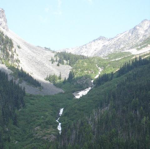
17 2.3 Natural Heritage Values Protected Watershed The conservancy, along with adjacent Birkenhead Lake Park, protects 15,327 hectares within the Birkenhead River watershed; a quarter of the watershed. The conservancy contains the headwaters of the Birkenhead River and two of its larger tributaries; Headquarters Creek and Tenquille Creek. These tributaries flow into the Birkenhead River from the west along with numerous smaller creeks which drain into the Birkenhead River. The Birkenhead River watershed is the largest in the Lillooet River watershed, encompassing 592 square kilometres of steep, mountainous terrain. Typical steep terrain in the Birkenhead Valley. Ecosystem Representation The conservancy is situated within the Leeward Pacific Ranges Ecosection; 26% of this ecosection is within protected areas, of which 5% is found in the Upper Birkenhead Conservancy. The conservancy contributes significantly to the protection of the Interior Mountain-heather Alpine, Qwalímak/Upper Birkenhead Conservancy Management Plan 11
18 undifferentiated (IMAun) variant, protecting almost 2% of IMAun found in the province, and contributing 9% to the IMAun found within the protected area system in British Columbia. The conservancy also protects significant amounts of two bioegeoclimatic units within the Leeward Pacific Ranges Ecosection, including 4% of the Coastal Western Hemlock southern moist submaritime (CWHms1) and 3% of the Engelmann Spruce subalpine fir moist warm parkland (ESSFmwp). The conservancy contributes 23% respectively to the representation of these biogeoclimatic units within the Leeward Pacific Ranges Ecosection (Appendix 2). Old-Growth Forests Past logging activities have removed much of the old-growth forests in the lower reaches of the watershed. Several Old Growth Management Areas were established under the Forest and Range Practices Act to preserve old-growth forests. High Value Fish Habitat The rivers and streams of the conservancy support habitat for salmon downstream. The Birkenhead River has limited glacial influence and its waters are relatively clear for most of the year. The river supports large numbers of Sockeye and smaller populations of Chinook, Pink, Chum and Coho. None of these anadromous salmon are found within the waters of the conservancy. Other fish species that occur in the watershed are Kokanee, Rainbow Trout, Coastal Cutthroat, Dolly Varden Char, Bull Trout, Mountain Whitefish, Large-scale Sucker and Sculpin. Important Wildlife Values The conservancy provides suitable habitat for a variety of wildlife species such as Grizzly Bear, Black Bear, Mountain Goat, Wolverine and the endangered Northern Spotted Owl. The Upper Birkenhead area is part of the threatened South Chilcotin Range population unit for Grizzly Bear; 16 bears have been detected by DNA with home ranges overlapping in this area. Mountain Goats are also present in the conservancy. A wolverine den has been located in the Sockeye Creek drainage to the west of the conservancy, and may indicate presence in the conservancy. Prior to the establishment of the conservancy, certain portions of the working forest were identified for habitat protection under the Forest and Range Practices Act. Wildlife Habitat Areas were set aside for Grizzly Bear. The General Wildlife Measures for Wildlife Habitat Areas are that no roads, trails, or landings will be constructed. Ungulate Winter Range (UWR) was set aside for Mountain Goat and Mule Deer. UWRs are intended to protect suitable habitat such as foraging opportunities, escape terrain and steep south facing slopes. Old Growth Management Areas are areas with old-growth forest values which provide habitat for species dependent on old-growth forests, including the endangered Northern Spotted Owl. Because these areas of habitat protection are now within a conservancy, the Forest and Range Practices Act has been superseded by the Park Act. However, the spatial extent of these habitat protection areas provides important information Qwalímak/Upper Birkenhead Conservancy Management Plan 12

19 and informs the management direction developed for the conservancy (Figure 4). These wildlife habitat areas include: Role three Grizzly Bear Wildlife Habitat Areas in the upper portion of the conservancy; and, four Ungulate Winter Range Areas for Mountain Goat overlap the conservancy boundary; and, several Old Growth Management Areas are located within, and adjacent to, the conservancy. The conservancy plays an important role in the protection of important ecological values including habitat for species of high conservation priority such as Grizzly Bear, Mountain Goat, Wolverine and Northern Spotted Owl. The conservancy contains several areas of old-growth forest and protects the headwaters of the Birkenhead River watershed which provides habitat for Sockeye, Chinook and Coho Salmon, along with many resident fish species. The conservancy also contributes to the protection of the neighbouring Birkenhead Lake Park, creating a large contiguous wilderness area totalling 15,327 hectares. A field of hakwa7 (Cow Parsnip) Qwalímak/Upper Birkenhead Conservancy Management Plan 13

20 Large avalanche chute provides important bear habitat. Qwalímak/Upper Birkenhead Conservancy Management Plan 14

21 Figure 4: Natural Features Qwalímak/Upper Birkenhead Conservancy Management Plan 15
22 Values 2.4 Recreation The conservancy offers limited recreational opportunities such as hiking and backcountry skiing. There are no recreational amenities within the conservancy. Currently there are motorised activities in the conservancy; management strategies have been developed to address this. It is not known at this time how many visitors the area receives on an annual basis. Existing tourism and recreation tenures overlapping the conservancy include: a commercial recreation licence for heli-skiing, held by Whistler Heli-Skiing Limited (land file # ). The current licence term ends in May a commercial recreation licence for guided horseback riding (land file # ), held by Chilcotin Holidays Ltd.; term expires A Forest Service Road which provided access to the conservancy has been decommissioned. Role This remote conservancy provides an opportunity for low-impact, non-motorised backcountry recreation in a wilderness setting. 2.5 Development or Use of Natural Resources The use of natural resources is limited to those activities described in the cultural values and recreation values section and the use of the two existing traplines. Other uses or development of natural resources, including local run-of-river projects, within the conservancy are not appropriate due to incompatibility with the role of the conservancy and the conservancy management objectives. Qwalímak/Upper Birkenhead Conservancy Management Plan 16

23 Remote wilderness terrain of the Qwalímak/Upper Birkenhead Conservancy. Qwalímak/Upper Birkenhead Conservancy Management Plan 17
24 3.0 Management Direction 3.1 Vision The Qwalímak/Upper Birkenhead Conservancy is a place that sustains the Lil wat People, physically, culturally and spiritually. The conservancy protects the Upper Birkenhead River headwaters and supports cultural values. The protection of the headwaters will help to protect the important fisheries and wildlife habitats known to occur downstream. Visitors to the conservancy enjoy a wilderness experience and an opportunity to gain an appreciation of Lil wat cultural heritage. 3.2 Management Objectives, Issues and Strategies The following table summarizes the management objectives, issues, and strategies for the conservancy. Objectives Issues Strategies Sustain and promote Lil wat Nation traditional uses including social, ceremonial and cultural activities. Lack of information available to the public about Lil wat Nation s rich cultural heritage may be impacting the area s cultural values. Use Ucwalmicwts language and place names on signs and in informational material developed for the conservancy. Interpretive signage may be installed at key access points to the conservancy or at existing sign kiosks in the area. Ensure that conservancy information products are culturally sensitive. Ensure that any tourism operations are culturally sensitive (information on cultural sensitivity will be incorporated through the park use permit referral process). Include conservancy information and mapping on signage in the Lower Birkenhead River watershed (e.g., on the active Forest Service Roads), at Birkenhead Lake Park, and at the entrance to the Hope Creek Forest Service Road. Qwalímak/Upper Birkenhead Conservancy Management Plan 18
25 Objectives Issues Strategies Maintain biodiversity and natural ecological processes. Recreational activities need to be managed to mitigate impacts to wildlife species sensitive to human presence (e.g., Grizzly Bear, Wolverine and Mountain Goat). Work with other agencies to ensure that motorised access on adjacent Crown lands and forest service roads (e.g. Hope Creek FSR) does not enable motorized access to the conservancy. Where there may be a risk to conservancy values, conduct inventories of invasive plants and, where needed, develop plans to address invasive species. Recommend a regulatory change to close the conservancy to hunting to protect Grizzly Bear and Mountain Goat populations and preserve the remote wilderness qualities of the conservancy. Ensure heli-skiing operations observe the Provincial Mountain Goat Management Plan Guidelines which state that no helicopter use should occur within 2,000 metres of Mountain Goat habitat. Potential impacts from neighbouring mining activities. Work with the appropriate provincial government agency to ensure that the access to any adjacent mining activities does not facilitate motorized access to the conservancy. Monitor status of the excluded mineral titles. When the tenures expire, pursue adding those portions of the tenures that are in the Upper Birkenhead watershed to the conservancy. Limited information on biodiversity values, particularly species at risk, makes it more difficult to protect these values. Complete an inventory for the presence of species at risk and support implementation of recovery plans. Qwalímak/Upper Birkenhead Conservancy Management Plan 19
26 Objectives Issues Strategies Avoid humanwildlife conflicts. Potential for bearhuman conflicts resulting from recreational activities in bear country. Provide education and information about wildlife in the area, including known Grizzly Bear habitat areas. Promote Bear Smart practices to reduce human-wildlife conflicts. All tenures and park use permits to be consistent with zoning and management objectives. Existing licenses occurring in the conservancy require park use permits. Pre-existing and valid tenure holders will be contacted to determine if they wish to continue to operate within the conservancy and may be transitioned to park use permits. Through the strategy above, the tenure terms will be reviewed and additional permit conditions may be required to minimize impacts to conservancy values. BC Parks and the Lil wat Nation will work with the heli-ski tenure holder to determine how to phase out this activity. Regulatory changes to prohibit aircraft landings may be recommended. The use of natural resources is limited to those activities described in the cultural values and recreation values section and the use of the two existing traplines. Other uses or development of natural resources, including local run-of-river projects, within the conservancy are not appropriate. 3.3 Zoning Zoning assists in the planning and management of conservancies and other protected areas by communicating and focusing management direction in particular areas using a landscape level approach. Management objectives for a spatial area describe the desired natural environment conditions and visitor experience opportunities on a given landscape. Qwalímak/Upper Birkenhead Conservancy Management Plan 20
27 Wilderness Conservation Zone The entire conservancy is zoned Wilderness Conservation to protect important wildlife habitat and ecological values. The intent of the Wilderness Conservation Zone is to place a high priority on conserving the natural environment, specifically habitats supporting Grizzly Bear and Mountain Goat populations. The use of pack animals and mountain bikes will not be permitted in the Wilderness Conservation Zone to minimize erosion in the watershed and potential damage to ecological and cultural features. This remote conservancy provides an opportunity for for lowimpact, unassisted backcountry recreation in a wilderness setting. This zoning is consistent with the adjacent Wilderness Conservation Zone in Birkenhead Lake Park, which protects the headwaters associated with Sockeye Creek. Qwalímak/Upper Birkenhead Conservancy Management Plan 21
28 4.0 Plan Implementation 4.1 Policy Context In addition to any area-specific policies highlighted in this conservancy management plan, there are numerous other provincial/regional policies and guidelines which will be considered during management plan implementation. This includes BC Parks policies on conservation, permitting and impact assessment processes, and broader government commitments to reduce greenhouse gas emissions. 4.2 Implementation BC Parks and Lil wat Nation will seek project-specific funding and partners to implement high priority strategies and to monitor key performance measures. Specific projects will be evaluated for priority in relation to the overall protected areas system. Many of the initiatives contemplated are not funded as part of core BC Parks activities so jointly seeking funds or partners will be a key aspect of management plan implementation. 4.3 Implementation Priorities The following strategies have been identified as high priorities for implementation: use Ucwalmicwts language and place names on signs and in informational material developed for the conservancy; pre-existing and valid tenure holders will be contacted to determine if they wish to continue to operate within the conservancy and may be transitioned to park use permits; develop a road deactivation strategy that includes bridge removals and road decommissioning; and, promote Bear Smart practices to reduce human-wildlife conflicts. Qwalímak/Upper Birkenhead Conservancy Management Plan 22
29 Appendix 1: Appropriate Uses Table The following table lists existing and potential future uses in the Qwalímak/Upper Birkenhead Conservancy. This is not an exhaustive list of uses that may be considered in this conservancy and does not restrict the exercise of Lil wat Nation aboriginal rights. Activities Hunting Fishing Trapping Horse Use/Pack Animals Guide Outfitting Mechanized Use (e.g. mountain biking) Motorized Use (e.g. including quads, 4x4s, dirt bikes, snowmobiles and snowcats) Heli-skiing Heli-hiking Aircraft Access Backcountry Skiing Hiking/Walking Backpacking Wilderness Conservation Zone N Y Y N N N N N N N Y Y Y Facilities/Infrastructure Huts/Cabins/Shelters Picnic Areas (vehicle accessed and serviced) Interpretive Signage Roads Parking Lots Trails Hydro Electric (Run-of-River) Projects and Infrastructure Wilderness Conservation Zone N N Y N N N N Qwalímak/Upper Birkenhead Conservancy Management Plan 23
30 Legend N Y N/A Not an appropriate use in this zone May be an appropriate use in this zone Not an applicable use in this zone It has been confirmed during the management planning process that this use is not appropriate in this zone. This may be an existing use which the management planning process has determined is no longer an appropriate use in this zone. The management plan details strategies for addressing this inappropriate use (e.g., phasing out, closing). This indicates that some degree or scale of this use may be appropriate. For existing uses, the management plan will provide guidance on the appropriate level or scale of this use (e.g., direction to reduce, restrict or increase the current level of this activity) and may address specific restrictions or enhancements (e.g., capacity, appropriate sites, designated trails, purposes, party size, time of year, etc.). For new or expanded uses, this does not constitute approval. This indicates that the use may be considered for further evaluation and possible approval (e.g., park use permit adjudication, completion of a review as part of the BC Parks Impact Assessment Process). In some cases the appropriateness may not be confirmed until further assessments are completed. This is applied where it is not feasible for the use to take place in this zone (e.g., mooring buoys in a terrestrial zone). Qwalímak/Upper Birkenhead Conservancy Management Plan 24

31 Appendix 2: Biogeoclimatic Zones Figure 5: Biogeoclimatic Zone Map Qwalímak/Upper Birkenhead Conservancy Management Plan 25
Bridge River Delta Park. Management Plan. Final Public Review Draft
 Bridge River Delta Park Management Plan Final Public Review Draft March 2016 Bridge River Delta Park Management Plan Approved by: Jeff Leahy Regional Director Thompson Cariboo Region BC Parks Date Brian
Fred Antoine Park. Management Plan. Final Public Review Draft
 Fred Antoine Park Management Plan Final Public Review Draft March 2016 Fred Antoine Park Management Plan Approved by: Jeff Leahy Regional Director Thompson Cariboo Region BC Parks Date Brian Bawtinheimer
Pillar Park. Management Plan
 Pillar Park Management Plan January 2014 Pillar Park Management Plan Approved by: Jeff Leahy Regional Director Thompson Cariboo Region BC Parks January 9, 2014 Date Brian Bawtinheimer Executive Director
Yard Creek Provincial Park. Management Plan
 Yard Creek Provincial Park Management Plan Draft January 2010 Yard Creek Provincial Park Management Plan Approved by: telàlsemkin/siyam/chief Scott Benton Bill Williams Squamish Executive Director ation
MANAGEMENT DIRECTION STATEMENT June, 1999
 Thompson River District MANAGEMENT DIRECTION STATEMENT June, 1999 for Roche Lake Provincial Park Ministry of Environment Lands and Parks BC Parks Division Table of Contents I. Introduction A. Setting
2.0 PARK VISION AND ROLES
 2.0 PARK VISION AND ROLES 2.1 Significance in the Protected Area System Marble Range and Edge Hills provincial parks protect 6.8% of the Pavillion Ranges Ecosection, which is located in the Southern Interior
D IRECTION S TATEMENT
 Vancouver Island Region M ANAGEMENT D IRECTION S TATEMENT September 2003 for Lower Nimpkish Provincial Park Ministry of Water, Land and Air Protection Environmental Stewardship Lower Nimpkish Provincial
MANAGEMENT DIRECTION STATEMENT June, 1999
 Thompson River District MANAGEMENT DIRECTION STATEMENT June, 1999 for Clearwater River Corridor (Addition to Wells Gray Park) Ministry of Environment Lands and Parks BC Parks Division ii Table of Contents
MANAGEMENT DIRECTION STATEMENT March 2003
 Skeena Region MAAGEMET DIRECTIO STATEMET March 2003 for Meziadin Lake Provincial Park Ministry of Water, Land and Air Protection Environmental Stewardsh Division This page left blank on purpose ii Table
Dragon Mountain Park. Management Plan. Public Review Draft
 Disclaimer: This draft management plan contains preliminary proposals that are subject to change and therefore may not necessarily reflect the position of the Ministry of Environment. At the conclusion
FINGER-TATUK PROVINCIAL PARK
 FINGER-TATUK PROVINCIAL PARK PURPOSE STATEMENT AND ZONING PLAN March 2003 FINGER-TATUK PROVINCIAL PARK Purpose Statement and Zoning Plan Finger-Tatuk Provincial Park is 17,151 ha in size. It includes the
Role of the Protected Area
 Role of the Protected Area Provincial and Regional Context Height of the Rockies and Elk Lakes provincial parks lie in southeastern British Columbia in the Rocky Mountains, about 85 km southwest of Calgary,
Stuart River Provincial Park Purpose Statement and Zoning Plan
 Stuart River Provincial Park Purpose Statement and Zoning Plan Stuart River Provincial Park protects three-quarters of the 110 kilometer long Stuart River corridor between Stuart Lake and the Nechako River.
As outlined in the Tatshenshini-Alsek Park Management Agreement, park management will:
 Management Strategy General Strategy The priority management focus for the park is to ensure that its internationally significant natural, cultural heritage and recreational values are protected and that
ANAGEMENT P LAN. July for Chilliwack Lake Park & Chilliwack River Ecological Reserve. Ministry of Environment, Lands and Parks BC Parks Division
 M ANAGEMENT P LAN July 2000 for Chilliwack Lake Park & Chilliwack River Ecological Reserve Ministry of Environment, Lands and Parks BC Parks Division Chilliwack Lake Provincial Park & Chilliwack River
APPENDIX. Alberta Land Stewardship Act AMENDMENTS TO THE SOUTH SASKATCHEWAN REGIONAL PLAN
 APPENDIX Alberta Land Stewardship Act AMENDMENTS TO THE SOUTH SASKATCHEWAN REGIONAL PLAN 1 All references to Alberta Environment and Sustainable Resource Development, Environment and Sustainable Resource
Kwadacha Wilderness Provincial Park and Kwadacha Addition (Kwadacha Recreation Area) Purpose Statement and Zoning Plan
 Purpose Statement and Zoning Plan") Kwadacha Wilderness Provincial Park and Kwadacha Addition (Kwadacha Recreation Area) Purpose Statement and Zoning Plan Located in a remote area of the northern interior of BC, this large park straddles
Kwadacha Wilderness Provincial Park and Kwadacha Addition (Kwadacha Recreation Area) Purpose Statement and Zoning Plan Located in a remote area of the northern interior of BC, this large park straddles
ARCTIC PACIFIC LAKES PROVINCIAL PARK
 ARCTIC PACIFIC LAKES PROVINCIAL PARK PURPOSE STATEMENT AND ZONING PLAN March 2003 ARCTIC PACIFIC LAKES PROVINCIAL PARK Purpose Statement and Zoning Plan Located 90 km northeast of Prince George in the
OMINEACA PROVINCIAL PARK
 OMINEACA PROVINCIAL PARK AND PROTECTED AREA PURPOSE STATEMENT AND ZONING PLAN March 2003 OMINECA PROVINCIAL PARK AND PROTECTED AREA Purpose Statement and Zoning Plan Omineca Park and Omineca Protected
Dragon Mountain Park. Management Plan
 Dragon Mountain Park Management Plan December 2015 Dragon Mountain Park Management Plan Approved by: Peter Weilandt A/Regional Director Thompson Cariboo Region BC Parks December 14. 2015 Date Brian Bawtinheimer
SUGARBOWL-GRIZZLY DEN PROVINCIAL PARK AND SUGARBOWL-GRIZZLY DEN PROTECTED AREA Purpose Statement and Zoning Plan
 SUGARBOWL-GRIZZLY DEN PROVINCIAL PARK AND SUGARBOWL-GRIZZLY DEN PROTECTED AREA Purpose Statement and Zoning Plan Located one hour east of Prince George on Highway 16, Sugarbowl-Grizzly Den Provincial Park
MAIN LAKE PROVINCIAL PARK
 MAIN LAKE PROVINCIAL PARK PURPOSE STATEMENT AND ZONING PLAN March 2003 MAIN LAKE PROVINCIAL PARK Purpose Statement and Zoning Plan Primary Role The primary role of Main Lake Park is to protect a biologically
ANAGEMENT P LAN. February, for Elk Lakes and Height of the Rockies Provincial Parks. Ministry of Environment, Lands and Parks BC Parks Division
 M ANAGEMENT P LAN February, 1999 for Elk Lakes and Height of the Rockies Provincial Parks Ministry of Environment, Lands and Parks BC Parks Division Elk Lakes & Height of the Rockies Provincial Parks M
STONE MOUNTAIN PROVINCIAL PARK Purpose Statement and Zoning Plan
 1 STONE MOUNTAIN PROVINCIAL PARK Purpose Statement and Zoning Plan Stone Mountain Provincial Park is situated 140 km west of Fort Nelson at Kilometre 595 of the Alaska Highway. The 25 690 ha park is located
MANAGEMENT DIRECTION STATEMENT June, 1999
 Garibaldi/Sunshine Coast District MAAGEMET DIRECTIO STATEMET June, 1999 for Homathko Estuary Provincial Park Ministry of Environment Lands and Parks BC Parks Division TABLE OF COTETS Introduction...1
Mackinnon Esker Ecological Reserve Draft - Management Plan
 Mackinnon Esker Ecological Reserve Draft - Management Plan May 2011 Photo Credit: This document replaces the direction provided in the Carp Lake Provincial Park and Protected Area and Mackinnon Esker Ecological
SLIM CREEK PROVINCIAL PARK
 SLIM CREEK PROVINCIAL PARK PURPOSE STATEMENT AND ZONING PLAN March 2003 1 Slim Creek Provincial Park Purpose Statement and Zoning Plan Slim Creek Provincial Park is located along Highway 16, approximately
MARBLE RIVER PROVINCIAL PARK
 MARBLE RIVER PROVINCIAL PARK PURPOSE STATEMENT AND ZONING PLAN March 2003 MARBLE RIVER PROVINCIAL PARK Purpose Statement and Zoning Plan Primary Role The primary role of Marble River Park is to protect
Appendix A BC Provincial Parks System Goals
 Appendix A BC Provincial Parks System Goals The British Columbia Provincial Parks System has two mandates: To conserve significant and representative natural and cultural resources To provide a wide variety
MANAGEMENT DIRECTION STATEMENT November 1999
 Garibaldi/Sunshine Coast District MAAGEMET DIRECTIO STATEMET ovember 1999 for Upper Lillooet Provincial Park Ministry of Environment Lands and Parks BC Parks Division UPPER LILLOOET PROVICIAL PARK APPROVALS
MANAGEMENT DIRECTION STATEMENT
 Lower Mainland District MAAGEMET DIRECTIO STATEMET January 2001 for Liumchen Ecological Reserve Ministry of Environment Lands and Parks BC Parks Division Table of Contents Page Introduction... 1 Purpose
MANAGEMENT DIRECTION STATEMENT
 Skeena District MAAGEMET DIRECTIO STATEMET July, 2000 for Driftwood Canyon Provincial Park Ministry of Environment Lands and Parks BC Parks Division i Table of Contents Driftwood Canyon Park Approvals
MANAGEMENT DIRECTION STATEMENT March 2003
 Skeena Region MAAGEMET DIRECTIO STATEMET March 2003 for Craig Headwaters Protected Area Ministry of Water, Land and Air Protection Environmental Stewardshi Division This management direction statement
Restore and implement protected status that is equivalent, or better than what was lost during the mid-1990 s
 THE ROSSLAND RANGE, OLD GLORY AREA. Executive summary. The Friends of the Rossland Range Society, on behalf of the local outdoor community, seeks to accomplish the following with respect to the Old Glory
5.0 OUTDOOR RECREATION OPPORTUNITIES AND MANAGEMENT
 5.0 OUTDOOR RECREATION OPPORTUNITIES AND MANAGEMENT 5.1 Introduction This section describes the range of recreational activities that currently take place in Marble Range and Edge Hills Parks, as well
Quesnel Lake Park. Management Plan
 Quesnel Lake Park Management Plan December 2015 Quesnel Lake Park Management Plan Approved by: December 14, 2015 Peter Weilandt A/Regional Director Thompson Cariboo Region BC Parks Date December 14, 2015
Marchand Provincial Park. Management Plan
 Marchand Provincial Park Management Plan 2 Marchand Provincial Park Table of Contents 1. Introduction... 3 2. Park History... 3 3. Park Attributes... 4 3.1 Natural... 4 3.2 Recreational... 4 3.3 Additional
Mackinnon Esker Ecological Reserve. Management Plan
 Mackinnon Esker Ecological Reserve Management Plan March 2017 Cover Page Photo Credit: Rob Bell This document replaces the direction provided in the Carp Lake Provincial Park and Protected Area and Mackinnon
Skihist Park. Management Plan. Draft for public review
 Skihist Park Management Plan Draft for public review August 2017 This document replaces the Skihist Park Management Plan (November 1996). Skihist Park Management Plan Approved by: Jeff Leahy Regional Director
April 10, Mark Stiles San Juan Public Lands Center Manager 15 Burnett Court Durango, CO Dear Mark,
 Mark Stiles San Juan Public Lands Center Manager 15 Burnett Court Durango, CO 81301 Dear Mark, We are pleased to offer the following comments on the draft San Juan Public Lands Center management plans
Fraser River Provincial Park Purpose Statement and Zoning Plan
 Fraser River Provincial Park Purpose Statement and Zoning Plan Fraser River Provincial Park is located on the west bank of the Fraser River, approximately 35 km south of Prince George. This 4,899 ha Protected
CARMANAH WALBRAN PROVINCIAL PARK
 CARMANAH WALBRAN PROVINCIAL PARK PURPOSE STATEMENT AND ZONING PLAN September 2003 1 CARMANAH WALBRAN PROVINCIAL PARK Purpose Statement and Zoning Plan Carmanah Walbran Provincial Park is an expansion of
MANAGEMENT DIRECTION STATEMENT
 Skeena District MAAGEMET DIRECTIO STATEMET August 2000 for Driftwood Extension to Babine Mountains Park Ministry of Environment Lands and Parks BC Parks Division This management direction statement was
MANAGEMENT DIRECTION STATEMENT March 2003
 Skeena Region MAAGEMET DIRECTIO STATEMET March 2003 for Great Glacier Provincial Park Ministry of Water, Land an Air Protection Environmental Stewardship Division ii This management direction statement
Sasagiu Rapids Provincial Park. Draft Management Plan
 Sasagiu Rapids Provincial Park Draft Management Plan 2 Sasagiu Rapids Provincial Park Table of Contents 1. Introduction... 3 2. Background and Park Attributes... 3 2.1 Park History.... 3 2.2 Natural Features...
SANTA-BOCA PROVINCIAL PARK
 SANTA-BOCA PROVINCIAL PARK PURPOSE STATEMENT AND ZONING PLAN March 2003 SANTA-BOCA PROVINCIAL PARK Purpose Statement and Zoning Plan Primary Role The primary role of Santa-Boca Park is to provide marine-based
MANAGEMENT DIRECTION STATEMENT March 2003
 Skeena Region MAAGEMET DIRECTIO STATEMET March 2003 for Lava Forks Provincial Park Ministry of Water, Land and Air Protection Environmental Stewardshi Division This management direction statement was
Clearwater Lake Provincial Park. Draft Management Plan
 Clearwater Lake Provincial Park Draft Management Plan Clearwater Lake Provincial Park Draft Management Plan Table of Contents 1. Introduction... 3 2. Park History... 4 3. Park Attributes... 4 3.1 Location/Access...4
ANAGEMENT. LAN November, 1996
 M ANAGEMENT P LAN November, 1996 for Paul Lake Provincial Park Ministry of Environment, Lands and Parks BC Parks Department Paul Lake Provincial Park M ANAGEMENT P LAN Prepared by BC Parks Kamloops Area
ANAGEMENT. LAN November, 1996
 M ANAGEMENT P LAN November, 1996 for Coldwater River Provincial Park Ministry of Environment, Lands and Parks BC Parks Department Coldwater River Provincial Park M ANAGEMENT P LAN Prepared by BC Parks
KOOTENAY LAKE PROVINCIAL PARK (MIDGE CREEK SITE)
") KOOTENAY LAKE PROVINCIAL PARK (MIDGE CREEK SITE) PURPOSE STATEMENT AND ZONING PLAN February 2003 Approved by: KOOTENAY LAKE PROVINCIAL PARK (Midge Creek Site) Purpose Statement and Zoning Plan Primary
KOOTENAY LAKE PROVINCIAL PARK (MIDGE CREEK SITE) PURPOSE STATEMENT AND ZONING PLAN February 2003 Approved by: KOOTENAY LAKE PROVINCIAL PARK (Midge Creek Site) Purpose Statement and Zoning Plan Primary
MANAGEMENT DIRECTION STATEMENT November 2003
 Skeena Region MANAGEMENT DIRECTION STATEMENT November 2003 for Sutherland River Provincial Park and Sutherland River Protected Area Ministry of Water, Land and Air Protection Environmental Stewardship
Sand Lakes Provincial Park. Draft Management Plan
 Sand Lakes Provincial Park Draft Management Plan 2 Sand Lakes Provincial Park Table of Contents 1. Introduction... 3 2. Background... 3 3. Park Purpose... 5 4. Park Management Guidelines... 6 Appendix...
Nakina Moraine Provincial Park. Interim Management Statement. Ontario. Ministry of Natural Resources
 Nakina Moraine Provincial Park Interim Management Statement Ontario Ministry of Natural Resources 1999, Queen's Printer for Ontario Printed in Ontario, Canada Additional copies of this publication can
Proposal to Redevelop Lower Kananaskis River-Barrier Lake. Bow Valley Provincial Park
 Frequently Asked Questions Proposal to Redevelop Lower Kananaskis River-Barrier Lake Bow Valley Provincial Park Frequently Asked Questions What has been decided? What are the details of the plan? What
Steps in the Management Planning Process
 Steps in the Management Planning Process Developing a management plan for Kalamalka Lake Park will follow a multi-stage process. The planning process for this park is currently in the Draft Management
Victor Lake Park. Management Plan
 Victor Lake Park Management Plan November 2012 Victor Lake Park Management Plan Approved by: Jeff Leahy, Regional Director Thompson Cariboo Region BC Parks March 28, 2012 Date Brian Bawtinheimer, Executive
Numaykoos Lake Provincial Park. Management Plan
 Numaykoos Lake Provincial Park Management Plan 2 Numaykoos Lake Provincial Park Table of Contents 1. Introduction... 3 2. Background... 3 3. Park Purpose... 5 4. Park Management Guidelines... 6 Appendix...
ONE ISLAND LAKE PROVINCIAL PARK Purpose Statement and Zoning Plan
 ONE ISLAND LAKE PROVINCIAL PARK Purpose Statement and Zoning Plan Primary Role The primary role of One Island Lake Provincial Park is to provide recreational opportunities to regional and residential area
Outdoor Recreation Opportunities Management
 Outdoor Recreation Opportunities Management Introduction The natural features of Height of the Rockies and Elk Lakes provincial parks provide a wide variety of outdoor recreational activities. However,
Policy PL Date Issued February 10, 2014
 Subject RENEWABLE ENERGY ON CROWN LAND Compiled by Renewable Energy Program, Biodiversity Branch Replaces Policy Directives Waterpower Site Release Crown Land Onshore Windpower Development - Crown Land
Finn Creek Park. Management Direction Statement Amendment
 Finn Creek Park Management Direction Statement Amendment November 2013 Management Direction Statement Amendment Approved by: Jeff Leahy Regional Director, Thompson Cariboo BC Parks November 12, 2013 Date
Peace Region. MANAGEMENT Plan. January for Toad River Hot Springs Provincial Park. Ministry of Environment. Environmental Stewardship Division
 Peace Region MANAGEMENT Plan January 2009 for Toad River Hot Springs Provincial Park Ministry of Environment Environmental Stewardship Division Toad River Hot Springs Park Approvals Page Forward This management
Proposal to Redevelop Lower Kananaskis River-Barrier Lake. Bow Valley Provincial Park. Frequently Asked Questions
 Proposal to Redevelop Lower Kananaskis River-Barrier Lake Bow Valley Provincial Park Frequently Asked Questions What is being proposed? What are the details of the proposal? Where is the project area located?
Brackendale Eagles Park Baynes Island Ecological Reserve Tantalus Park. Management Plan. February Squamish Nation
 Brackendale Eagles Park Baynes Island Ecological Reserve Tantalus Park Brackendale Eagles Park Baynes Island Ecological Reserve Tantalus Park February 2012 Squamish Nation This document replaces the direction
Whitemouth Falls Provincial Park. Draft Management Plan
 Whitemouth Falls Provincial Park Draft Management Plan Whitemouth Falls Provincial Park Draft Management Plan Table of Contents 1. Introduction... 3 2. Park History... 3 3. Park Attributes... 4 3.1 Natural...
Watchorn Provincial Park. Management Plan
 Watchorn Provincial Park Management Plan 2 Watchorn Provincial Park Table of Contents 1. Introduction... 3 2. Park History... 3 3. Park Attributes... 3 3.1 Natural... 4 3.2 Recreational... 4 3.3 Additional
PROUDLY BRINGING YOU CANADA AT ITS BEST. Management Planning Program NEWSLETTER #1 OCTOBER, 2000
 PROUDLY BRINGING YOU CANADA AT ITS BEST VUNTUT NATIONAL PARK Management Planning Program NEWSLETTER #1 OCTOBER, 2000 INTRODUCTION This newsletter launches the development of the first management plan for
Little Limestone Lake Provincial Park. Draft Management Plan
 Little Limestone Lake Provincial Park Draft Management Plan Little Limestone Lake Provincial Park Draft Management Plan Table of Contents 1. Introduction... 3 2. Background... 3 3. Planning context...
BIGHORN BACKCOUNTRY ACCESS MANAGEMENT PLAN
 BIGHORN BACKCOUNTRY ACCESS MANAGEMENT PLAN October, 2002 SPECTACULAR BY NATURE BIGHORN BACKCOUNTRY Alberta s Bighorn Backcountry offers spectacular Rocky Mountain scenery and unforgettable recreational
BLANKET CREEK PROVINCIAL PARK
 BLANKET CREEK PROVINCIAL PARK PURPOSE STATEMENT AND ZONING PLAN February 2003 BLANKET CREEK PROVINCIAL PARK Purpose Statement and Zoning Plan Primary Role The primary role of Blanket Creek Park is to maintain
D IRECTION S TATEMENT
 Vancouver Island Region M AAGEMET D IRECTIO S TATEMET September 2003 for Woss Lake Provincial Park Ministry of Water, Land an Air Protection Environmental Stewardship Division Woss Lake Provincial Park
Continental Divide National Scenic Trail Legislative History and Planning Guidance
 Continental Divide National Scenic Trail Legislative History and Planning Guidance Legislation, Policy, and Direction Regarding National Scenic Trails The National Trails System Act, P.L. 90-543, was passed
NECHAKO CANYON PROTECTED AREA
 NECHAKO CANYON PROTECTED AREA PURPOSE STATEMENT AND ZONING PLAN March 2003 1 Nechako Canyon Protected Area Purpose Statement and Zoning Plan The Nechako Canyon Protected Area (1,246 hectares) is located
Approval Statement. Brian Pfrimmer, Central Zone Manager Ontario Parks
 Approval Statement I am pleased to approve this Interim Management Statement for Dividing Lake Provincial Nature Reserve. This Nature Reserve contains biological features of provincial significance and
Wallace Lake Provincial Park. Management Plan
 Wallace Lake Provincial Park Management Plan 2 Wallace Lake Provincial Park Table of Contents 1. Introduction... 3 2. Park History... 3 3. Park Attributes... 4 3.1 Natural... 4 3.2 Recreational... 4 4.
Beaver Creek Provincial Park. Management Plan
 Beaver Creek Provincial Park Management Plan 2 Beaver Creek Provincial Park Table of Contents 1. Introduction... 3 2. Park History... 3 3. Park Attributes... 4 3.1 Natural... 4 3.2 Recreational... 4 4.
A GUIDE TO MANITOBA PROTECTED AREAS & LANDS PROTECTION
 A GUIDE TO MANITOBA PROTECTED AREAS & LANDS PROTECTION Manitoba Wildands December 2008 Discussions about the establishment of protected lands need to be clear about the definition of protection. We will
Appendix A Chilko Lake Protected Area Intent and Management Principles
 Appendix A Chilko Lake Protected Area Intent and Management Principles 95 Intent and Management Principles (as prescribed by the Chilko Lake Study Team) General Intent This proposed Chilko Lake Protected
PEMBERTON VALLEY RECREATIONAL TRAILS MASTER PLAN UPDATE Community Open House. April 2018
 PEMBERTON VALLEY RECREATIONAL TRAILS MASTER PLAN UPDATE Community Open House April 2018 Introductions Introductions Matt Bakker, BHA Project Coordinator Other Team Members: Liz Scroggins, Grey Owl Consulting
KANANASKIS COUNTRY PROVINCIAL RECREATION AREAS MANAGEMENT PLAN DRAFT TERMS OF REFERENCE - November 20, 2007
 KANANASKIS COUNTRY PROVINCIAL RECREATION AREAS MANAGEMENT PLAN DRAFT TERMS OF REFERENCE - November 20, 2007 BACKGROUND There are 42 Provincial Recreation Areas (PRAs) within Kananaskis Country located
Land Management Summary
 photo credit: ANGAIR Anglesea Heath Land Management Summary The Anglesea Heath (6,501 ha) was incorporated into the Great Otway National Park in January 2018. This provides an opportunity to consider the
Bighorn Country Proposal
 Bighorn Country Proposal Have your say at TalkAEP.ca Improving Bighorn Country for a Growing Alberta Bighorn Country contains some of the greatest unrealized tourism potential in Alberta for its unique
MANAGEMENT DIRECTION STATEMENT October, 1999
 Thompson River District MAAGEMET DIRECTIO STATEMET October, 1999 for Wire Cache Provincial Park Ministry of Environment Lands and Parks BC Parks Division Ministry of Environment, Lands and Parks BC Parks
September Morice Lake Park Management Plan
 September 2010 Morice Lake Park Management Plan Cover photo M. Parminter, BC Parks. Morice Lake Park Management Plan Approved by: Scott Benton Executive Director Parks and Protected Areas Division May
Pembina Valley Provincial Park. Draft Management Plan
 Pembina Valley Provincial Park Draft Management Plan 2 Pembina Valley Provincial Park Table of Contents 1. Introduction... 3 2. Park History... 3 3. Park Attributes... 3 3.1 Natural... 3 3.2 Recreational...
WORKSHEET 1 Wilderness Qualities or Attributes Evaluating the Effects of Project Activities on Wilderness Attributes
 WORKSHEET 1 Wilderness Qualities or Attributes Evaluating the Effects of Project Activities on Wilderness Attributes Date: 3/7/2017 Roadless Area: Ruby South Description of Project Activity or Impact to
BROUGHTON ARCHIPELAGO PROVINCIAL PARK
 BROUGHTON ARCHIPELAGO PROVINCIAL PARK PURPOSE STATEMENT AND ZONING PLAN March 2003 BROUGHTON ARCHIPELAGO PROVINCIAL PARK Purpose Statement and Zoning Plan Primary Role The primary role is to contribute
SHUSWAP LAKE MARINE PROVINCIAL PARK
 SHUSWAP LAKE MARINE PROVINCIAL PARK Purpose Statement and Zoning Plan The primary role of the Shuswap Lake Marine Provincial Park is to provide a system of sites for marine overnight and day use of Shuswap
Birch Point Provincial Park. Management Plan
 Birch Point Provincial Park Management Plan 2 Birch Point Provincial Park Table of Contents 1. Introduction... 3 2. Park History... 3 3. Park Attributes... 4 3.1 Natural... 4 3.2 Recreational... 4 4. Park
Monkman Provincial Park. Master Plan
 Monkman Provincial Park Master Plan Table of Contents Plan Highlights...1 Section One: Introduction What is a Master Plan?...4 Relationship With Other Land Use Planning...6 How This Plan Was Prepared...7
HOLE IN THE WALL PROVINCIAL PARK
 HOLE IN THE WALL PROVINCIAL PARK PURPOSE STATEMENT AND ZONING PLAN Peace Region 2006 Approved by: Andy Ackerman, Regional Manager Environmental Stewardship Division Peace Region Date: 2006 Nancy Wilkin
VARGAS ISLAND PROVINCIAL PARK
 VARGAS ISLAND PROVINCIAL PARK PURPOSE STATEMENT AND ZONING PLAN February 2003 VARGAS ISLAND PROVINCIAL PARK Purpose Statement and Zoning Plan Primary Role The primary role of Vargas Island Park is to protect
Outdoor Recreation Opportunities Management
 Outdoor Recreation Opportunities Management Introduction A major role of a management plan is to provide direction regarding the types of recreation that are appropriate, and to outline the steps that
South Atikaki Provincial Park. Draft Management Plan
 South Atikaki Provincial Park Draft Management Plan South Atikaki Provincial Park Draft Management Plan Table of Contents 1. Introduction... 3 2. Park History... 3 3. Park Attributes... 3 3.1 Natural...
Lake Acreage Mcleese Lake, BC
 Lake Acreage Mcleese Lake, BC Jason Zroback jason@landquest.com 1 (604) 414-5577 Jamie Zroback jamie@landquest.com 1 (604) 483-1605 The Source for Oceanfront, Lakefront, Islands, Ranches, Resorts & Land
Criddle/Vane Homestead Provincial Park. Draft Management Plan
 Criddle/Vane Homestead Provincial Park Draft Management Plan 2 Criddle/Vane Homestead Provincial Park Table of Contents 1. Introduction... 3 2. Park History.... 3 3. Park Attributes.... 3 3.1 Natural....
Criddle/Vane Homestead Provincial Park. Management Plan
 Criddle/Vane Homestead Provincial Park Management Plan 2 Criddle/Vane Homestead Provincial Park Table of Contents 1. Introduction... 3 2. Park History.... 3 3. Park Attributes.... 4 3.1 Natural.... 4 3.2
South Chilcotin Mountains Park and Big Creek Park. Management Plan. Final Public Review Draft
 South Chilcotin Mountains Park and Big Creek Park Management Plan Final Public Review Draft March 2016 This document replaces the Big Creek Park Management Direction Statement, approved in November 1999.
Sawtooth National Forest Fairfield Ranger District
 United States Department of Agriculture Forest Service Sawtooth National Forest Fairfield Ranger District P.O. Box 189 Fairfield, ID. 83327 208-764-3202 Fax: 208-764-3211 File Code: 1950/7700 Date: December