MANAGEMENT DIRECTION STATEMENT November 2003
|
|
|
- Felicia Jacobs
- 5 years ago
- Views:
Transcription

1 Skeena Region MANAGEMENT DIRECTION STATEMENT November 2003 for Sutherland River Provincial Park and Sutherland River Protected Area Ministry of Water, Land and Air Protection Environmental Stewardship Division
2
3 The Vanderhoof Land and Resource Management Plan and the Lakes District Land and Resource Management Plan provided direction for this management direction statement.
4 Table of Contents Page Introduction Purpose of the Management Direction Statement...1 Context...1 Provincial Park and Protected Area Attributes Conservation...2 Recreation and Tourism...4 Commercial Business Opportunities...4 Cultural Heritage...4 Significance in the Protected Areas System...4 Land Uses, Tenures and Interests Access...6 Existing Tenures, Alienations and Encumbrances...6 Existing Land Use Activities and Facilities...7 Adjacent Patterns of Land Use...7 First Nations Interests...7 Other Agency Interests...8 Private and Public Stakeholder Interests...9 Sutherland River Provincial Park and Sutherland River Protected Area Role Statement...9 Management Commitments and Issues Management Direction from Previous Planning...10 Management Issues...11 Management Direction Priority Management Objectives and Strategies...12 Consultation and Future Planning...15 Zoning Plan...15 Figures Figure 1. Regional Context Map...3 Figure 2. Tenures and Land Use Map...5 Figure 3. Provincial Park and Protected Area Zoning Map...17 Appendices Appendix 1. Table of Acceptable Activities, Uses, and Facilities...18
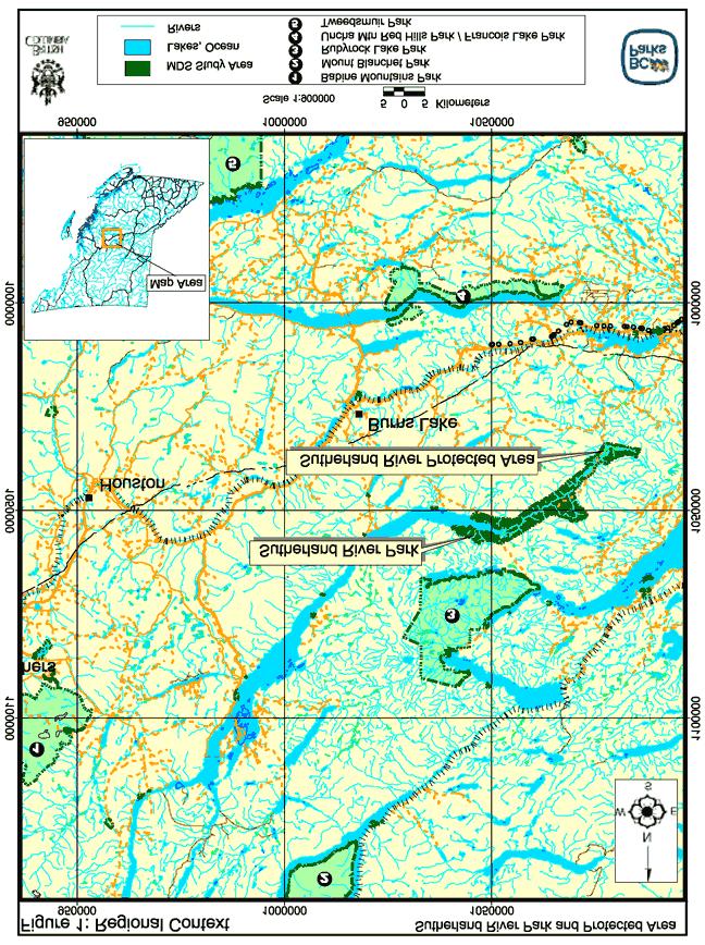
5 Sutherland River Provincial Park and Sutherland River Protected Area Management Direction Statement Introduction Purpose of the Management Direction Statement Management direction statements (MDS) provide strategic management direction for protected areas that do not have an approved management plan. Management direction statements also describe protected area values, management issues and concerns; management strategy focused on immediate priority objectives and strategies; and, direction from other planning processes. While the MDS identifies strategies, the completion of all these strategies is dependent on funding and funding procedures. All development associated with these strategies is subject to Parks and Protected Areas Branch Impact Assessment Policy. Context The provincial government established Sutherland River Provincial Park under the Protected Areas of British Columbia Act in April, The provincial government established Sutherland Protected Area by Order in Council 993/00 under the Environment and Land Use Act in July, The Vanderhoof and Lakes Land and Resource Management Plans (LRMPs) identified Sutherland River Provincial Park and Sutherland River Protected Area as Goal 1 protected area candidates to protect representative ecosystems, special habitats and grizzly, ungulate and fisheries habitats. Sutherland River Park and Protected Area includes special features considered as Goal 2 protected areas. One area within the park is under consideration for designation as an Ecological Reserve. Designation followed the recommendations of the LRMPs. Sutherland River Provincial Park and Sutherland River Protected Area together cover a 18,394 hectare corridor along Sutherland River at the southeast end of Babine Lake. The park and protected area lie about 55 kilometres northeast of the Village of Burns Lake (area population of about 4,000 people) and 40 kilometres northwest of the Village of Fraser Lake (area population of about 2,000 people). The community of Fort St. James (area population of approximately 2,000 people) sits about 30 kilometres east of the park and protected area. The provincial government established Sutherland River Protected Area to allow industrial access through the southeast portion of the corridor and across Sutherland River. This access is no longer required. The park and protected area lie within the asserted traditional territory of the Carrier-Sekani Tribal Council (representing Nadleh Whut en, Nakazdli, Tl azt en First Nations), Nat oot en First Nation and Yekooche First Nation. Nadleh Village is located 30 kilometres to the southeast; Tachie (Tl azt en) sits 20 kilometres to the northeast across Stuart Lake while IR#13 (Yekooche), between the park and Babine Lake, is occupied seasonally. The park and protected area occupy both banks of the Sutherland River and the east end of Babine Lake. The park and protected area include a remarkable variety of ecosystems, including the pine, spruce, subalpine fir and aspen forests typical of the region as well as the only unmodified sub-boreal spruce floodplain in the province and rare grassland communities. The variety of ecosystems provide habitat for waterfowl, moose, deer, grizzly bear and fish and offer 1
6 a range of outdoor recreation opportunities including boating and angling on Babine Lake, hunting and fishing along the Sutherland River floodplain and backcountry hiking and camping. Sutherland River Provincial Park connects to the system of Babine Lake Marine Provincial Park sites by water. Pendelton Bay (a site in Babine Lake Marine Provincial Park) is the closest campground facility. Rubyrock Lake Provincial Park protects ecosystems between Cunningham Lake, Stuart Lake and Trembleur Lake seven kilometres north of Sutherland River Provincial Park. Provincial Park and Protected Area Attributes Conservation Protects representative landscapes within the fragmented and poorly represented Babine Upland Ecosection. Only 4% of Babine Upland Ecosection is protected. Sutherland River Park and Sutherland River Protected Area are the second largest contributors to the protected area representation of this ecosection (25%) behind Rubyrock Lake Provincial Park (55%). Primarily SBSdk (dry cool sub-boreal spruce subzone) and SBSmc2 (Babine moist cold sub-boreal spruce subzone); also about 1,000 hectares of ESSFmv1 (moist very cold Engelmann spruce subalpine fir subzone) and AT (alpine tundra); includes one fifth of SBSdk protected in British Columbia; one of only five parks protecting ESSFmv1 in British Columbia. Conservation values rated as very high by the Regional Protected Areas Team; ranked 4 th highest of 84 parks in the Skeena Region according to the Conservation Risk Assessments due to values of and risks to rare plant communites (only the much larger Tatshenshini Alsek Provincial Park, Mount Edziza Provincial Park and Recreation Area and Spatsizi Plateau Wilderness Provincial Park rank higher). Contains some of the most extensive and best-developed Douglas-fir ecosystems in the Skeena Region (along with Uncha Mountain Red Hills Provincial Park). Protects the biologically exceptional meandering Sutherland River and associated floodplain and extensive wetlands the only unmodified SBSdk floodplain in the province. Contains rare plant communities including: saskatoon-slender wheatgrass (SBSdk/81, SBSmc2/81; red-listed) on dry south-facing slopes; cottonwood-dogwood-prickly rose (SBSdk/08; red-listed) on floodplains; white spruce-horsetail (SBSdk/07; recommended for red-list) on floodplains; Douglas-fir-feathermoss-stepmoss (SBSdk/04; blue-listed) on south-facing rocky knolls; and, Drummond s willow-mountain alder low bench floodplains (SBSdk, SBSmc2; recommended for blue-list). Protects canyon walls and cliffs with high plant diversity. Conserves the following wildlife values: high to very high quality moose winter range in the floodplain; high value spring grizzly bear habitat in wetlands and lower slopes; habitat for reptiles and insects in dry Douglas-fir and scrub-steppe plant communities; and, excellent waterfowl habitat near to Babine Lake. Contains provincially significant fish habitat: Sutherland River is the spawning and rearing channel for more than 80% of Babine Lake rainbow trout (an internationally significant fishery); Shass Creek is an important sockeye salmon spawning area; and, the southeast end of the Sutherland River has a steelhead run. 2
7 3
8 Recreation and Tourism Outdoor recreation values rated as medium to high by Regional Protected Areas Team. Babine Lake provides opportunities for angling and boating. Sutherland River Valley provides opportunities for backcountry hiking, camping, fishing and hunting in a wilderness area with high scenic value. A waterfall and associated rock walls offer rock-climbing and viewing opportunities. Opportunities exist for wildlife viewing. Commercial Business Opportunities Provides moderate to high commercial business opportunities for guided hunting and fishing activities. (See Appendix 1 for activities allowed in this park and protected area). Provides moderate to high commercial business opportunities for guided interpretation based tour groups focused on the natural ecosystems (e.g., undisturbed floodplain), cultural heritage features, scenery, wildlife viewing and wilderness environment of this park and protected area. Cultural Heritage Traditionally important route for travel, communication and trade among First Nations - a trail along Sutherland River Valley linked Fraser Lake, Babine Lake and Stuart Lake; other trails pass through the park. Tl azt en cultural heritage trails are mapped; Tl azt en intended the completion of a traditional use study in the summer of 2002; Yekooche are planning a traditional use study of Tetzalto ( Detzalto ) Mountain; Nadleh Whut en are working on a land use study. Traditionally used for hunting, fishing and gathering. First Nations used the old fishing camps, north of the river, seasonally. First Nations used some areas for gardens. People still use trails and stay in and near the park for several months in summer to hunt, fish and maintain trapping trails. Contains six recorded archaeological sites, including a pictograph, cache sites and lithics; Yekooche report large unrecorded burial sites (undocumented locations). Yekooche elders speak of a protected canyon where cameras do not work. Heritage trail from Fraser Lake to Stuart Lake was later named the Fraser Lake Stuart Lake Pack Trail; part of the trail has been maintained. Decaying settler cabins exist throughout the protected area. Significance in the Protected Areas System Protects representative ecosystems within the fragmented Babine Upland (BAU) Ecosection of which only 4% is conserved in 19 protected areas. Sutherland River Park and Sutherland River Protected Area protects 25% of the ecosection. One of only three parks with significant BAU representation in British Columbia. Includes one fifth of SBSdk protected in British Columbia (less than 1% of the subzone is protected in British Columbia); one of only five parks protecting ESSFmv1 in British Columbia (less than 1% of the subzone is protected in the province). 4
9 5
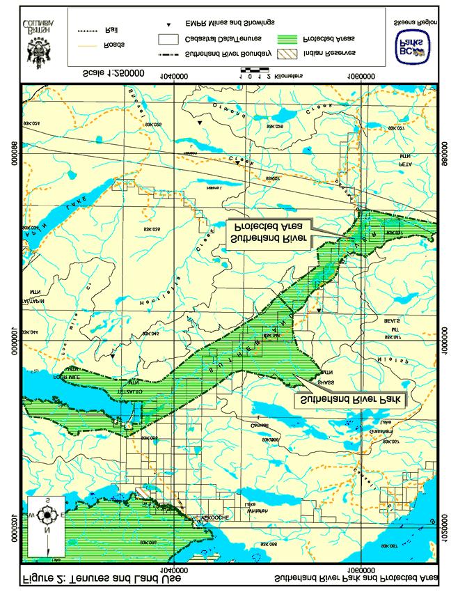
10 Protects provincially significant plant communities and the only unaltered SBSdk floodplain in the province. Conserves provincially significant fish, moose and grizzly bear habitat. Offers backcountry wilderness outdoor recreation opportunities within 40 kilometres of a populated area. Protects special outdoor recreation features including an unusual box canyon and a waterfall. Babine Lake offers exceptional angling and boating opportunities. Cultural features ranked highly diverse and moderately rare in Conservation Risk Assessment. Protects a portion of a First Nations heritage trail running through the river valley from Fort Fraser to Portage on Stuart Lake, later named the Fort Fraser Stuart Pack Trail. Land Uses, Tenures and Interests Access Boat access to the southeast end of Babine Lake is common. The Sutherland River is not navigable beyond the first few kilometres. The Augier-Grizzly Forest Service Road from Burns Lake reaches the south side of Babine Lake. This road is deactivated near Tetzalto Mountain before the park boundary. The Sutherland-Oona Forest Service Road reaches the protected area 35 kilometres from Vanderhoof at the junction with the Shass Mountain Trail Forest Service Road (previously a mining exploration road; also called Sutherland River Forest Service Road). The Shass Mountain Trail provides rough four wheeled drive access to the Sutherland River within the southeastern end of the protected area. A log bridge crosses the river, and the road continues through the protected area to the north of the river. From Fort Fraser, the Sutherland- Tatsutnai and Sutherland-Trout Forest Service roads join the Sutherland-Oona Road. Finally, a rough road leaves the Cunningham Lake Forest Service Road on the north side of the protected area and passes through the park to provide access to private lots, including IR#13 on the south end of Babine Lake. Existing Tenures, Alienations and Encumbrances Three guide-outfitters operate within the park and protected area; one guide has three registered cabins to the north of Sutherland River with access from the Shass Mountain Trail. Park use permit SK authorises one of the guide-outfitter operations until March It is not known whether the other guide-outfitters are active in the park. Several trappers operate within the park and protected area. Park use permit SK authorises one of the trapline operations until It is not known whether the other trappers are active in the park. A Ministry of Water Land and Air Protection (Wildlife Habitat Section) reserve encompasses the river valley for planned enhancement of moose habitat. Utility corridor - Twin Reserve Lines cross Sutherland River just north of Peta Mountain (may include southernmost portion of protected area - maps are inconsistent). Within the park, two recreational cabins with water access from the south side of Babine Lake (leased with Land and Water BC tenure) are used seasonally. 6
11 Existing Land Use Activities and Facilities In the northwest portion (i.e., the provincial park), access is by foot or boat, and activities are mostly confined to the lake and lakeshore, including angling, boating and camping. Some hikers climb Tetzalto Mountain on the south shore of Babine Lake and the rocky ridge on the north shore. Trappers and hunters use trails along the river. Tl azt en First Nation trappers are expanding their trail network using ATVs. In the southeast portion (i.e., the protected area), access is from the Shass Mountain Trail (four wheel drive), and activities include horseback riding, fishing, hunting, snowmobiling and hiking. Facilities include three guide-outfitter cabins, 25 kilometres of trails near the Shass Mountain Trail maintained by the guide outfitter and the Fraser Lake-Stuart Lake Pack Trail. Guide-outfitter drives clients along Shass Mountain Trail and keeps 10 pack horses in the protected area during hunting season (one month). Adjacent Patterns of Land Use Four private lots at the southeast part of Babine Lake are excluded from the protected area; Lot 969 was previously farmed - buildings and equipment remain; no known activities on the other lots. People use IR#13 during spring and summer. Gillnetting occurs at the mouth of Sutherland River and on many small creeks draining into Babine Lake. Within the Vanderhoof District, the northeast boundary of the protected area joins a Special Resource Management Zone (i.e., the Upper Sutherland Resource Management Zone) managed to emphasise wildlife, fisheries and scenic values, but also to allow timber harvest while minimising adverse effects. Within the Vanderhoof District, the southern boundary is next to a Resource Development Emphasis Zone (i.e., the Vanderhoof North Resource Management Zone) managed with minimal access restrictions. Within the Lakes District, the park borders General Resource Management zones managed to integrate multiple values. First Nations Interests Asserted traditional territory of the Yekooche First Nation, Nat oot en First Nation and Carrier-Sekani Tribal Council (including Nadleh Whut en, Nakazdli, Tl azt en First Nations). Yekooche First Nation, Nat oot en First Nation and Tl azt en First Nation chose to present their issues for inclusion in this management direction statement; Nadleh Whut en presented some issues, but did not want to be involved in official consultation until they had established a relationship with the Ministry of Water, Land and Air Protection, Skeena Region; Nakazdli claim only a tiny portion of the protected area, and felt that their concerns would be addressed through meetings with Yekooche and Tl azt en First Nations (due to relatedness). All First Nations extensively use Sutherland River Provincial Park and Sutherland River Protected Area and surrounding area for subsistence hunting and gathering. 7
12 First Nations (listed in brackets) raised several issues listed below in discussions with Environmental Stewardship Division representatives. The list is incomplete as not all First Nations wished to participate in the management direction statement planning process. Title (Nadleh Whut en) - claim title to the land covered by the park and protected area. Consultation (Nadleh Whut en, Nad u ten, Tl azt en) - Nadleh Whut en would like Environmental Stewardship Division to follow Nadleh consultation policy. Tl azt en would like three-way meetings with Yekooche and Environmental Stewardship Division and would like Key-oh holders to be consulted. Park boundary (Yekooche, Nadleh Whut en) - would like the park expanded to include Shass Mountain (important to Yekooche for wildlife habitat and cultural heritage values), and Ormand and Oona Lakes (sacred site to Nadleh Whut en). Cultural sites and artifacts (Yekooche) - want to be informed if Environmental Stewardship Division becomes aware of cultural sites; want artifacts surrendered to Royal British Columbia Museum in trust until claimed by appropriate First Nations representative. Archaeology (Nadleh Whut en) - would like to complete an archaeological study involving elders and other knowledgeable Nadleh Whut en; would like funding and cooperation of Environmental Stewardship Division. Cultural education (Tl azt en) - interest in reviving fish camps to the north of the river and using them for cultural education. Heritage trail development (Tl azt en and Yekooche) - interest in developing the heritage trail along Sutherland River for cultural and eco-tourism purposes. Access to trapping (Tl azt en, Nat oot en) - interest in maintaining access to trapping and hunting; Tl azt en have cleared a trail network (will provide GPS locations to Environmental Stewardship Division) - use snowmobiles in winter and ATVs in summer. Cabins (Tl azt en, Nadleh Whut en) - Tl azt en trapper plans to build cabin at the junction of Sutherland River and Gravel Creek; Nadleh Whut en councillor plans to build hunting cabin within the park. Bridge over Sutherland River (Tl azt en, Nadleh Whut en) - Nadleh Whut en have an interest in having a proper bridge across the river to improve access; Tl azt en prefer not to have a bridge to avoid increases in access. Employment (Nadleh Whut en, Tl azt en) - interest in any employment opportunities within the park (e.g., beetle control, fisheries enhancement, cultural trail development). Beetle control (Yekooche, Nadleh Whut en) - interest in controlling beetles inside and outside park; Yekooche First Nation interested in finding funds elsewhere if Environmental Stewardship Division is unable to control beetles within the park. Logging (Yekooche) - interested in no logging in the park (claim that Babine Forest Products had plans to log within park). Other Agency Interests The Ministry of Water, Land and Air Protection, Skeena Region Fish and Wildlife Science and Allocation Section, has an interest in wildlife and habitat, including grasslands, riparian areas, deer winter range, moose habitat, seasonal grizzly bear habitat, critical rainbow trout spawning habitat, and rare plant communities. 8
13 The Ministry of Forests (Lakes District and Vanderhoof District) has an interest in preventing the spread of mountain pine beetles. The Ministry of Forests (Vanderhoof District) has an interest in relinquishing responsibility for the Shass Mountain Trail Forest Service Road to Environmental Stewardship Division. The Department of Fisheries and Oceans has an interest in maintaining sockeye salmon spawning habitat. The Ministry of Sustainable Resource Management, British Columbia Conservation Data Centre (CDC) has an interest in the species at risk in the park and protected area. Private and Public Stakeholder Interests Forest companies (i.e., Babine Forest Products, West Fraser, Northwood) have an interest in preventing the spread of mountain pine beetle populations. Three guide-outfitters have an interest in the park and protected area. One has cabins and an interest in leading horseback trips for wildlife viewing and wilderness camping as well as hunting (primarily moose). Trapline holders have an interest in the park and protected area because the park and protected area require the application of the Park Act and the Park and Recreation Areas Regulation governing the operation of such a business. Burns Lake Snowmobile Club; Vanderhoof Snowmobile Club; snowmobilers have an interest because they occasionally use guide-outfitter cabins. Burns Lake Power Squadron uses the southeast end of Babine Lake. Nechako Valley Saddle Club uses the park and protected area for horseback riding. Rock climbers, hikers, backcountry recreationists, hunters, anglers have an interest in the outdoor recreation opportunities the park and protected area present to visitors. Ecologists are interested in the park and protected area s protection of outstanding natural values and the undisturbed floodplain. Local communities including Fort St. James, Fraser Lake, Tachie and Fort Fraser are interested in the outdoor recreation opportunities and economic contributions of the park and protected area. Park and protected area neighbours (at head of Babine Lake) have an interest in selling land to province for protected area purposes. Sutherland River Provincial Park and Sutherland River Protected Area Role Statement The primary role of Sutherland River Provincial Park and Sutherland River Protected Area is to conserve representative ecosystems and provincially significant plant communities, particularly south-aspect grasslands, and important wildlife habitat ranging from wet floodplain to dry upland ecosystems. The wide floodplain and associated wetlands of the Sutherland River are the only unaltered SBSdk floodplain communities in the province. The floodplain also contains critical spawning and rearing habitat for most of the rainbow trout living in Babine Lake. The dry upland grasslands, scrub-steppe and open forests provide valuable spring forage, and harbour migrating birds, reptiles and uncommon insects. The park and protected area also conserves diverse cultural heritage features. 9
14 The park and protected area perform a highly significant secondary role for tourism and outdoor recreation. The southeast end of the protected area offers exceptional opportunities for backcountry outdoor recreation within 40 kilometres of a populated area. A section of a First Nations heritage trail, now called the Fort Fraser Stuart Pack Trail, crosses the protected area. Wildlife viewing, angling and visits to special features, including a box-canyon and waterfall add to the outdoor recreation opportunities. Outdoor recreation activities in the northwest portion of the protected area are an extension of the exceptional boating, angling and camping associated with Babine Lake, the largest natural lake 1 entirely within British Columbia. Management Commitments and Issues Direction from Previous Planning In 1997, the Vanderhoof LRMP recommended the Sutherland River Valley for protection because of the valley s high values associated with the river corridor and the south-aspect open aspen forest. In 2000, the Lakes District LRMP recommended the adjacent portion of the river valley and southeast portion of Babine Lake for ecosection representation and for protection of grizzly bear, ungulate and fisheries habitat, and special habitats. The Lakes District LRMP included Babine Ecological Reserve Proposal (ERP) #378 and Goal 2 Sutherland River sites (biologically exceptional and including rare species) within the larger Goal 1 provincial park. Following from an earlier Local Resource Use Plan for the area, the Vanderhoof LRMP provides explicit objectives and strategies for the protected area including the following (see Appendix A of the LRMP for full text): Maintain spawning habitat; monitor and maintain water quality; consider soil erosion in planning. Research, identify and manage archaeological, historic and cultural heritage values. Maintain existing opportunities for hunting, angling, hiking and ecotourism; develop or enhance trail systems. Inventory wildlife habitats and plan for their conservation; maintain existing distribution of forest types by proactive management such as burning and manual brushing; decrease aspen encroachment; limit grazing by horses to that associated with recreation. Manage beetle population expansions from endemic levels while maintaining natural forest attributes. Minimise disturbance to non-motorised recreational users and encourage opportunities for non-motorised recreation; maintain existing primitive road status; restrict use of motorised vehicles to existing road; manage access (to north of river) to protect wildlife and biodiversity values. A Vanderhoof Access Management Plan (1998) calls for access control where the Shass Mountain Trail Forest Service Road crosses Sutherland River, closing non-industrial motorised access year-round to the north of the river. At the time the plan was developed, the Shass Mountain Trail Forest Service Road was to be used to harvest trees to the north of the protected area via a portable bridge across the river. Industrial use of this road is no longer planned, but the recommendations of the Access Management Plan have not been updated. 1 Atlin Lake is much larger in surface area but a small portion of the lake is within the Yukon Territory. 10
15 The Lakes District LRMP does not provide specific management direction for Sutherland River Provincial Park and Sutherland River Protected Area, but does provide general direction for all protected areas (excerpted below; full text in Appendix B of the Lakes District LRMP). Develop mountain pine beetle management strategies for each protected area Manage vegetation where grasslands have become ingrown as a result of fire suppression Management Issues Environmental Stewardship Division identified the following management issues: Theme Issue Protected Area status Protected Area status no longer appropriate because the proposed industrial road through the protected area is not required. Provincial Park status The LRMP supports designation of 330 hectares at the southeast end of Babine Lake in Sutherland River Provincial Park as an ecological reserve because such status will provide better protection of the natural values. Protecting ecological values The park and protected area s flora, fauna, and important habitats, especially species at risk, rare plant species and plant communities may be vulnerable to harm because an inventory of these values is incomplete. The protected area s natural environment may be damaged because the Shass Mountain Trail Forest Service Road (originally a mining road) crosses the protected area and poses potential sedimentation (poor ditching; inconsistent maintenance) and has the potential for increased recreation road traffic that might disturb wildlife. The existing distribution of age classes and species in open forests and scrub-steppe ecosystems might change because of forest fire suppression. The park and protected area s native vegetation and rare plant communities may be at risk because of colonisation by non-native plant species and weeds brought in by horse users. Aspen encroachment might decrease forage value for moose and grizzly bear and displace grasslands. Summer motorised use of meadows and floodplains could seriously damage plant communities and soils. Winter motorised use (snowmobiles) of Douglas-fir forests could disturb mule deer. Angling pressure during spawning season could affect rainbow trout spawning success. Forest harvesting next to the protected area boundary could damage ecological values. As forest management develops outside the park boundaries, access to the park will become easier, possibly posing threats to ecological values. Managing access across Retention of the Shass Mountain Trail Forest Service Road bridge Sutherland River is the subject of controversy because: The bridge is seen as unsafe (Ministry of Forests); It is used for access (guide-outfitter); There is concern about too easy access (some First Nations, wildlife and fisheries biologists); 11
16 Theme Protecting outdoor recreation opportunities and features Protecting cultural heritage values Issue There is concern about damage to fish habitat if bridge is removed (fisheries officers, First Nations, fishers); and, There is fear of loss of access (some First Nations, guideoutfitter). Conflicts with other park visitors may arise because a popular snowmobile route runs through the park from Babine Lake to Cunningham and Stuart lakes. Motorised and non-motorised outdoor recreation activities may not be compatible because of noise and air pollution, resulting in conflicts. Outdoor recreation opportunities may be reduced and features damaged because of forest harvesting and mineral exploration on lands next to the park and protected area. Cultural heritage values and features may be at risk because an inventory of these values is incomplete. Archaeological and cultural sites within the park may be damaged by high outdoor recreation use. First Nations values Environmental Stewardship Division faces management challenges concerning the differing views various First Nations have of the lands and waters comprising the park and protected area. Environmental Stewardship Division asked by First Nations to address the following concerns and issues: Full consultation (defined differently by different First Nations); Maintain trapping, hunting and gathering activities, including options to expand trail network and build cabins; Develop cultural and ecotourism facilities (camps and trails); and, Access to employment opportunities in the park and protected area. Relationship with neighbours Expansion of park and protected area boundaries may be appropriate because private land holders would like to sell land at the mouth of Sutherland River. Park and protected area forests may be threatened because of mountain pine beetle populations moving into the park from the Fort St. James Forest District to the north. Management Direction The vision for Sutherland River Provincial Park and Protected Area includes protection of the vast diversity of ecosystems and associated wildlife, traditional use by First Nations people, backcountry outdoor recreation use of the river valley, and boating, angling and camping use of Babine Lake. The following table describes management strategies to deal with identified management issues. In addition, Appendix 1 provides a list of acceptable activities, uses and facilities in the park and protected area. Priority Management Objectives and Strategies Objective To change and upgrade protected area classification To establish an ecological reserve within the provincial park Strategy Change the designation of Sutherland Protected Area to a Class A park under the Park Act. Investigate interest and need to designate the proposed portion of Sutherland Provincial Park as an ecological reserve under the Ecological Reserve Act. 12
17 Objective To manage access across Sutherland River To protect the park s outdoor recreation features and opportunities To protect the park s ecological values Strategy Work with guide outfitter and Ministry of Forests (Vanderhoof District) to manage access across the river; options include upgrading bridge to Environmental Stewardship Division standards, keeping existing bridge, posting warning signs and/or locked gate (allowing access for guide-outfitter only), and removing bridge and gating road to prevent fording. Consider, in consultation with Ministry of Forests, options for maintaining Shass Mountain Trail FSR and for maintaining existing primitive road status. Evaluate proposals to clear and develop the heritage trail for nonmotorised recreation use; work with First Nations, guide outfitters, trappers and local community members. Work with guide outfitter to continue maintenance of non-motorised trails around Shass Mountain Trail FSR. Designate Babine Lake Cunningham Lake Stuart Lake Trail for snowmobile use. Monitor impacts of snowmobile use on other recreation users and on wildlife. If impacts become unacceptable, close park to recreational snowmobile use. Collaborate with Ministry of Forests to reduce the effects of logging in adjacent areas on recreation users (e.g., timing of operations, visual quality considerations). Implement an inventory of the park and protected area s fauna and flora with priority given to the following: Rare riparian and upland plant communities; Critical grizzly bear foraging areas along river valley; and, Critical moose calving areas on south facing slopes and waterfall and box canyon. Work with Ministry of Water, Land and Air Protection, Skeena Region Fish and Wildlife Section to inventory fish, moose and grizzly bears as necessary. Monitor sediment entering hydroriparian system from Shass Mountain Trail FSR; manage appropriately; consider upgrading road or controlling access as necessary Monitor outdoor recreation use of Shass Mountain Trail FSR; if use increases with the potential to disturb wildlife, manage appropriately; consider access control as necessary. Develop a fire management plan; consider using prescribed burning to prevent encroachment of grassland, scrub-steppe and open forest ecosystems; maintain natural fire cycles of fire-dependent ecosystems. Consider manual brushing (including hinging) to prevent aspen encroachment of grassland and scrub-steppe ecosystems. Establish photo plots to evaluate change in plant community composition and the effect on listed plant communities. Allow continued horseback riding (guide-outfitter and recreational use) on trails associated with Shass Mountain Trail; work with guideoutfitter and horseback riding clubs to minimise impacts; provide information on low impact horse riding practices to visitors; monitor horse use and ecological damage. Restrict summer motorised use to existing road and limited ATV use associated with trapping tenures. Work with trapline holders to limit trail development and ATV use in the park. 13
18 Objective To protect the park s cultural heritage values To respect First Nation interests and values To bring existing commercial business tenures under valid permits To maintain relationships with park and protected area neighbours Strategy Allow snowmobile use only on designated trail, except for use associated with tenured trappers. Work with Ministry of Forests (Lakes and Vanderhoof Districts) and forest companies to minimise impacts of forest harvesting on ecological values. If recreation use increases as access to the park becomes easier, monitor impacts and manage appropriately (e.g., access control); work with Ministry of Forests and Forest Licensees to restrict motorised access to the park from new roads. Monitor impacts of rock climbing activities. Provide tenures to all guide-outfitters and trappers active in the park. Monitor introduction of noxious weeds and undertake control measures if necessary. Investigate and collate existing information on cultural heritage values in collaboration with appropriate First Nations representatives. Investigate need to protect cultural or archaeological sites; work with appropriate First Nations representatives. Surrender artifacts to Royal British Columbia Museum in trust until claimed by appropriate First Nations representative. Recognise that several First Nations have overlapping claims and that different First Nations have different interests in the park. Follow Ministry guidelines on consultation; where possible, consider specific First Nation consulting protocols. Inform appropriate First Nations representatives if Environmental Stewardship Division becomes aware of cultural sites. Encourage archaeological and traditional use studies involving elders and other knowledgeable First Nations representatives; work with First Nations to write funding proposals. Encourage revival of fish camps to the north of the river for cultural education. Authorise limited ATV use associated with trapping trail maintenance in park use permit. Encourage First Nations to build cabins necessary to support aboriginal traditional uses and activities or trapping outside of the park and protected area. If a cabin is necessary within the park, ensure that a proper location and size is determined in consultation with the appropriate First Nation and following application of the Parks and Protected Areas Branch Impact Assessment Policy. Notify appropriate First Nations representatives of potential employment opportunities; discuss procedure with all First Nations having overlapping claims in advance. Contact the trapline owners to place their trapping operations affecting the park and protected area under valid park use permits. Contact guide-outfitter operators (includes hunting, fishing and tour guiding) using the park and protected area to place their operations under valid park use permits. Collaborate with the Ministry of Forests (Vanderhoof and Lakes Districts) to develop a pine and spruce beetle management plan for the park and protected area. Discuss option for Yekooche involvement in funding. Pursue opportunity to adding private land at the mouth of Sutherland River to the park. 14
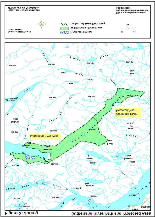
19 Objective To provide information to park and protected area visitors Strategy Provide accurate and current information about Sutherland River Provincial Park and Protected Area on the official Ministry of Water, Land and Air Protection web site. Emphasise the park and protected area s conservation role rather than outdoor recreation themes. Consultation and Future Planning Environmental Stewardship Division will consult with all pertinent First Nations and stakeholders as issues arise. Environmental Stewardship Division ranks Sutherland Provincial Park and Sutherland River Protected Area as moderate for the preparation of a management plan with full public consultation. Zoning Plan This management direction statement applies three management planning zones to Sutherland River Provincial Park and Sutherland River Protected Area which involve the following: Special Feature Zone Objective: To protect and present significant natural or cultural resources, features or processes because of their special character, fragility and heritage values. Zone Description: This zone contains about 300 hectares and focuses on the waterfall and box canyon on Shass Creek. In addition, Special Feature Zone covers the area for the proposed ecological reserve until it is designated under the Ecological Reserve Act. Management Guidelines: High level of management protection with ongoing monitoring. Oriented to maintaining values and, where appropriate, a high quality recreational and interpretative experience. Active or passive management depending on the size, location, and nature of the feature. Visitor access may be restricted to preserve the recreation experience and to limit impacts. Natural Environment Zone Objective: To protect scenic values and to provide for backcountry recreation opportunities in a largely undisturbed natural environment. Description: The Natural Environment Zone contains about 20 hectares and covers a corridor around the Shass Mountain Trail Forest Service Road and the designated snowmobile trail to allow motorised snowmobile use. Management Guidelines: Oriented to maintaining a natural environment and a high quality recreation experience. Visitor access may be restricted to preserve the recreation experience or to limit impacts. Separation of less compatible recreational activities and transportation modes. Designation of transportation may be necessary to avoid potential conflicts (e.g., horse trails, cycle paths, hiking trails). Wilderness Recreation Zone Objective: To protect a remote, undisturbed natural landscape and to provide backcountry recreation opportunities dependent on a pristine environment where air access may be permitted to designated sites. Zone Description: This zone covers all of Sutherland River Provincial Park and Sutherland River Protected Area not contained within the Special Feature or Natural Environment zones. 15
20 Management Guidelines: Oriented to protecting a pristine environment. Management actions are minimal and not evident. Managed to ensure low visitor use levels. Visitor access may be restricted to protect the natural environment and visitor experience. Note: Mapped zoning will need to be amended following air photo analyses and ground verification to incorporate Natural Environment Zone and refine Special Feature Zone. 16
21 17
22 Appendix 1. Sutherland River Provincial Park and Sutherland River Protected Area Table of Acceptable Activities, Uses and Facilities Activity/Use/Facility Acceptability Park Protected Area Aboriginal traditional activities and uses Y Y Hunting Y Y Fishing Y Y Trapping Y Y Grazing (domestic livestock) N N2 (associated with guide-outfitting) Recreational gold panning/rock hounding N N Utility corridors N N2 Communication sites N N Horse use Y on designated trails Y on designated trails Pack animals N N Guide outfitting (hunting) Y Y Guide outfitting (fishing) Y Y Guide outfitting (nature tours) Y Y Guide outfitting (river rafting) N N Cat-assisted skiing N N Ski hills N N Commercial recreation (facility-based) N N2 Commercial recreation (non-facility-based) Y Y Backcountry huts M M Water control structures N N Fish stocking and enhancement N N Road access N Existing FS Road Off-road access (snowmobiling) Y on designated trail N Off-road access (motorised) N N Off-road access (mechanical activities) N N Motorised water access Y N Aircraft access Y Y Fire management (suppression) Y Y Fire management (prescribed fire management) Y subject to fire management plan Y subject to fire management plan Fire management (prevention) Y Y Forest insect/disease control N1 N1 Noxious weed control Y Y Exotic insect/disease control N1 N1 Scientific research (specimen collection) M M Scientific research (manipulative activities) M M Y = allowed subject to conditions identified in the management direction statement or management plan M = may be permitted if compatible with protected area objectives N = not allowed N1 = allowed for expressed management purposes only N2 = present and allowed to continue, but not normally allowed 18
MANAGEMENT DIRECTION STATEMENT March 2003
 Skeena Region MAAGEMET DIRECTIO STATEMET March 2003 for Meziadin Lake Provincial Park Ministry of Water, Land and Air Protection Environmental Stewardsh Division This page left blank on purpose ii Table
MANAGEMENT DIRECTION STATEMENT June, 1999
 Thompson River District MANAGEMENT DIRECTION STATEMENT June, 1999 for Roche Lake Provincial Park Ministry of Environment Lands and Parks BC Parks Division Table of Contents I. Introduction A. Setting
MANAGEMENT DIRECTION STATEMENT June, 1999
 Thompson River District MANAGEMENT DIRECTION STATEMENT June, 1999 for Clearwater River Corridor (Addition to Wells Gray Park) Ministry of Environment Lands and Parks BC Parks Division ii Table of Contents
MANAGEMENT DIRECTION STATEMENT
 Skeena District MAAGEMET DIRECTIO STATEMET July, 2000 for Driftwood Canyon Provincial Park Ministry of Environment Lands and Parks BC Parks Division i Table of Contents Driftwood Canyon Park Approvals
MANAGEMENT DIRECTION STATEMENT
 Skeena District MAAGEMET DIRECTIO STATEMET August 2000 for Driftwood Extension to Babine Mountains Park Ministry of Environment Lands and Parks BC Parks Division This management direction statement was
MANAGEMENT DIRECTION STATEMENT March 2003
 Skeena Region MAAGEMET DIRECTIO STATEMET March 2003 for Lava Forks Provincial Park Ministry of Water, Land and Air Protection Environmental Stewardshi Division This management direction statement was
MANAGEMENT DIRECTION STATEMENT March 2003
 Skeena Region MAAGEMET DIRECTIO STATEMET March 2003 for Great Glacier Provincial Park Ministry of Water, Land an Air Protection Environmental Stewardship Division ii This management direction statement
Stuart River Provincial Park Purpose Statement and Zoning Plan
 Stuart River Provincial Park Purpose Statement and Zoning Plan Stuart River Provincial Park protects three-quarters of the 110 kilometer long Stuart River corridor between Stuart Lake and the Nechako River.
FINGER-TATUK PROVINCIAL PARK
 FINGER-TATUK PROVINCIAL PARK PURPOSE STATEMENT AND ZONING PLAN March 2003 FINGER-TATUK PROVINCIAL PARK Purpose Statement and Zoning Plan Finger-Tatuk Provincial Park is 17,151 ha in size. It includes the
MANAGEMENT DIRECTION STATEMENT March 2003
 Skeena Region MAAGEMET DIRECTIO STATEMET March 2003 for Craig Headwaters Protected Area Ministry of Water, Land and Air Protection Environmental Stewardshi Division This management direction statement
Yard Creek Provincial Park. Management Plan
 Yard Creek Provincial Park Management Plan Draft January 2010 Yard Creek Provincial Park Management Plan Approved by: telàlsemkin/siyam/chief Scott Benton Bill Williams Squamish Executive Director ation
MANAGEMENT DIRECTION STATEMENT June, 1999
 Garibaldi/Sunshine Coast District MAAGEMET DIRECTIO STATEMET June, 1999 for Homathko Estuary Provincial Park Ministry of Environment Lands and Parks BC Parks Division TABLE OF COTETS Introduction...1
As outlined in the Tatshenshini-Alsek Park Management Agreement, park management will:
 Management Strategy General Strategy The priority management focus for the park is to ensure that its internationally significant natural, cultural heritage and recreational values are protected and that
MANAGEMENT DIRECTION STATEMENT
 Lower Mainland District MAAGEMET DIRECTIO STATEMET January 2001 for Liumchen Ecological Reserve Ministry of Environment Lands and Parks BC Parks Division Table of Contents Page Introduction... 1 Purpose
OMINEACA PROVINCIAL PARK
 OMINEACA PROVINCIAL PARK AND PROTECTED AREA PURPOSE STATEMENT AND ZONING PLAN March 2003 OMINECA PROVINCIAL PARK AND PROTECTED AREA Purpose Statement and Zoning Plan Omineca Park and Omineca Protected
SUGARBOWL-GRIZZLY DEN PROVINCIAL PARK AND SUGARBOWL-GRIZZLY DEN PROTECTED AREA Purpose Statement and Zoning Plan
 SUGARBOWL-GRIZZLY DEN PROVINCIAL PARK AND SUGARBOWL-GRIZZLY DEN PROTECTED AREA Purpose Statement and Zoning Plan Located one hour east of Prince George on Highway 16, Sugarbowl-Grizzly Den Provincial Park
2.0 PARK VISION AND ROLES
 2.0 PARK VISION AND ROLES 2.1 Significance in the Protected Area System Marble Range and Edge Hills provincial parks protect 6.8% of the Pavillion Ranges Ecosection, which is located in the Southern Interior
MANAGEMENT DIRECTION STATEMENT February 2001
 Thompson River District MAAGEMET DIRECTIO STATEMET February 2001 for Greenstone Mountain Provincial Park Ministry of Environmen Lands and Parks BC Parks Division Table of Contents Introduction... 1 Purpose
D IRECTION S TATEMENT
 Vancouver Island Region M ANAGEMENT D IRECTION S TATEMENT September 2003 for Lower Nimpkish Provincial Park Ministry of Water, Land and Air Protection Environmental Stewardship Lower Nimpkish Provincial
NECHAKO CANYON PROTECTED AREA
 NECHAKO CANYON PROTECTED AREA PURPOSE STATEMENT AND ZONING PLAN March 2003 1 Nechako Canyon Protected Area Purpose Statement and Zoning Plan The Nechako Canyon Protected Area (1,246 hectares) is located
MANAGEMENT DIRECTION STATEMENT October, 1999
 Thompson River District MAAGEMET DIRECTIO STATEMET October, 1999 for Wire Cache Provincial Park Ministry of Environment Lands and Parks BC Parks Division Ministry of Environment, Lands and Parks BC Parks
Fred Antoine Park. Management Plan. Final Public Review Draft
 Fred Antoine Park Management Plan Final Public Review Draft March 2016 Fred Antoine Park Management Plan Approved by: Jeff Leahy Regional Director Thompson Cariboo Region BC Parks Date Brian Bawtinheimer
Peace Region. MANAGEMENT Plan. January for Toad River Hot Springs Provincial Park. Ministry of Environment. Environmental Stewardship Division
 Peace Region MANAGEMENT Plan January 2009 for Toad River Hot Springs Provincial Park Ministry of Environment Environmental Stewardship Division Toad River Hot Springs Park Approvals Page Forward This management
ANAGEMENT P LAN. February, for Elk Lakes and Height of the Rockies Provincial Parks. Ministry of Environment, Lands and Parks BC Parks Division
 M ANAGEMENT P LAN February, 1999 for Elk Lakes and Height of the Rockies Provincial Parks Ministry of Environment, Lands and Parks BC Parks Division Elk Lakes & Height of the Rockies Provincial Parks M
MARBLE RIVER PROVINCIAL PARK
 MARBLE RIVER PROVINCIAL PARK PURPOSE STATEMENT AND ZONING PLAN March 2003 MARBLE RIVER PROVINCIAL PARK Purpose Statement and Zoning Plan Primary Role The primary role of Marble River Park is to protect
MANAGEMENT DIRECTION STATEMENT March 2003
 Skeena Region MAAGEMET DIRECTIO STATEMET March 2003 for Lowe Inlet Marine Provincial Park Ministry of Water, Land and Air Protection Environmental Stewardshi Division This page left blank on purpose
Role of the Protected Area
 Role of the Protected Area Provincial and Regional Context Height of the Rockies and Elk Lakes provincial parks lie in southeastern British Columbia in the Rocky Mountains, about 85 km southwest of Calgary,
MANAGEMENT DIRECTION STATEMENT October, 1999
 Thompson River District MAAGEMET DIRECTIO STATEMET October, 1999 for Harry Lake Aspen Provincial Park Ministry of Environment Lands and Parks BC Parks Division Ministry of Environment, Lands and Parks
MANAGEMENT DIRECTION STATEMENT October, 1999
 Thompson River District MAAGEMET DIRECTIO STATEMET October, 1999 for Chu Chua Cottonwood Provincial Park Ministry of Environment Lands and Parks BC Parks Division Ministry of Environment, Lands and Parks
Appendix A BC Provincial Parks System Goals
 Appendix A BC Provincial Parks System Goals The British Columbia Provincial Parks System has two mandates: To conserve significant and representative natural and cultural resources To provide a wide variety
Fraser River Provincial Park Purpose Statement and Zoning Plan
 Fraser River Provincial Park Purpose Statement and Zoning Plan Fraser River Provincial Park is located on the west bank of the Fraser River, approximately 35 km south of Prince George. This 4,899 ha Protected
Bridge River Delta Park. Management Plan. Final Public Review Draft
 Bridge River Delta Park Management Plan Final Public Review Draft March 2016 Bridge River Delta Park Management Plan Approved by: Jeff Leahy Regional Director Thompson Cariboo Region BC Parks Date Brian
Kwadacha Wilderness Provincial Park and Kwadacha Addition (Kwadacha Recreation Area) Purpose Statement and Zoning Plan
 Purpose Statement and Zoning Plan") Kwadacha Wilderness Provincial Park and Kwadacha Addition (Kwadacha Recreation Area) Purpose Statement and Zoning Plan Located in a remote area of the northern interior of BC, this large park straddles
Kwadacha Wilderness Provincial Park and Kwadacha Addition (Kwadacha Recreation Area) Purpose Statement and Zoning Plan Located in a remote area of the northern interior of BC, this large park straddles
Outdoor Recreation Opportunities Management
 Outdoor Recreation Opportunities Management Introduction The natural features of Height of the Rockies and Elk Lakes provincial parks provide a wide variety of outdoor recreational activities. However,
Sand Lakes Provincial Park. Draft Management Plan
 Sand Lakes Provincial Park Draft Management Plan 2 Sand Lakes Provincial Park Table of Contents 1. Introduction... 3 2. Background... 3 3. Park Purpose... 5 4. Park Management Guidelines... 6 Appendix...
MANAGEMENT DIRECTION STATEMENT October, 1999
 Thompson River District MAAGEMET DIRECTIO STATEMET October, 1999 for orth Thompson Islands Provincial Park Ministry of Environment Lands and Parks BC Parks Division Ministry of Environment, Lands and Parks
STONE MOUNTAIN PROVINCIAL PARK Purpose Statement and Zoning Plan
 1 STONE MOUNTAIN PROVINCIAL PARK Purpose Statement and Zoning Plan Stone Mountain Provincial Park is situated 140 km west of Fort Nelson at Kilometre 595 of the Alaska Highway. The 25 690 ha park is located
5.0 OUTDOOR RECREATION OPPORTUNITIES AND MANAGEMENT
 5.0 OUTDOOR RECREATION OPPORTUNITIES AND MANAGEMENT 5.1 Introduction This section describes the range of recreational activities that currently take place in Marble Range and Edge Hills Parks, as well
ANAGEMENT. LAN November, 1996
 M ANAGEMENT P LAN November, 1996 for Paul Lake Provincial Park Ministry of Environment, Lands and Parks BC Parks Department Paul Lake Provincial Park M ANAGEMENT P LAN Prepared by BC Parks Kamloops Area
Dragon Mountain Park. Management Plan. Public Review Draft
 Disclaimer: This draft management plan contains preliminary proposals that are subject to change and therefore may not necessarily reflect the position of the Ministry of Environment. At the conclusion
BLANKET CREEK PROVINCIAL PARK
 BLANKET CREEK PROVINCIAL PARK PURPOSE STATEMENT AND ZONING PLAN February 2003 BLANKET CREEK PROVINCIAL PARK Purpose Statement and Zoning Plan Primary Role The primary role of Blanket Creek Park is to maintain
HOLE IN THE WALL PROVINCIAL PARK
 HOLE IN THE WALL PROVINCIAL PARK PURPOSE STATEMENT AND ZONING PLAN Peace Region 2006 Approved by: Andy Ackerman, Regional Manager Environmental Stewardship Division Peace Region Date: 2006 Nancy Wilkin
MAIN LAKE PROVINCIAL PARK
 MAIN LAKE PROVINCIAL PARK PURPOSE STATEMENT AND ZONING PLAN March 2003 MAIN LAKE PROVINCIAL PARK Purpose Statement and Zoning Plan Primary Role The primary role of Main Lake Park is to protect a biologically
KOOTENAY LAKE PROVINCIAL PARK (MIDGE CREEK SITE)
") KOOTENAY LAKE PROVINCIAL PARK (MIDGE CREEK SITE) PURPOSE STATEMENT AND ZONING PLAN February 2003 Approved by: KOOTENAY LAKE PROVINCIAL PARK (Midge Creek Site) Purpose Statement and Zoning Plan Primary
KOOTENAY LAKE PROVINCIAL PARK (MIDGE CREEK SITE) PURPOSE STATEMENT AND ZONING PLAN February 2003 Approved by: KOOTENAY LAKE PROVINCIAL PARK (Midge Creek Site) Purpose Statement and Zoning Plan Primary
Mackinnon Esker Ecological Reserve Draft - Management Plan
 Mackinnon Esker Ecological Reserve Draft - Management Plan May 2011 Photo Credit: This document replaces the direction provided in the Carp Lake Provincial Park and Protected Area and Mackinnon Esker Ecological
Muscovite Lakes Provincial Park Purpose Statement and Zoning Plan
 Muscovite Lakes Provincial Park Purpose Statement and Zoning Plan Muscovite Lakes Provincial Park is a 5,708-hectare park located on the western shore of Williston Reservoir, approximately 135 kilometres
Dragon Mountain Park. Management Plan
 Dragon Mountain Park Management Plan December 2015 Dragon Mountain Park Management Plan Approved by: Peter Weilandt A/Regional Director Thompson Cariboo Region BC Parks December 14. 2015 Date Brian Bawtinheimer
Clearwater Lake Provincial Park. Draft Management Plan
 Clearwater Lake Provincial Park Draft Management Plan Clearwater Lake Provincial Park Draft Management Plan Table of Contents 1. Introduction... 3 2. Park History... 4 3. Park Attributes... 4 3.1 Location/Access...4
Marchand Provincial Park. Management Plan
 Marchand Provincial Park Management Plan 2 Marchand Provincial Park Table of Contents 1. Introduction... 3 2. Park History... 3 3. Park Attributes... 4 3.1 Natural... 4 3.2 Recreational... 4 3.3 Additional
Numaykoos Lake Provincial Park. Management Plan
 Numaykoos Lake Provincial Park Management Plan 2 Numaykoos Lake Provincial Park Table of Contents 1. Introduction... 3 2. Background... 3 3. Park Purpose... 5 4. Park Management Guidelines... 6 Appendix...
BROUGHTON ARCHIPELAGO PROVINCIAL PARK
 BROUGHTON ARCHIPELAGO PROVINCIAL PARK PURPOSE STATEMENT AND ZONING PLAN March 2003 BROUGHTON ARCHIPELAGO PROVINCIAL PARK Purpose Statement and Zoning Plan Primary Role The primary role is to contribute
ONE ISLAND LAKE PROVINCIAL PARK Purpose Statement and Zoning Plan
 ONE ISLAND LAKE PROVINCIAL PARK Purpose Statement and Zoning Plan Primary Role The primary role of One Island Lake Provincial Park is to provide recreational opportunities to regional and residential area
MILLIGAN HILLS PROVINCIAL PARK
 MILLIGAN HILLS PROVINCIAL PARK PURPOSE STATEMENT AND ZONING PLAN Peace Region 2006 Approved by: Andy Ackerman, Regional Manager Environmental Stewardship Division Peace Region Date: 2006 Nancy Wilkin Assistant
Watchorn Provincial Park. Management Plan
 Watchorn Provincial Park Management Plan 2 Watchorn Provincial Park Table of Contents 1. Introduction... 3 2. Park History... 3 3. Park Attributes... 3 3.1 Natural... 4 3.2 Recreational... 4 3.3 Additional
Beaver Creek Provincial Park. Management Plan
 Beaver Creek Provincial Park Management Plan 2 Beaver Creek Provincial Park Table of Contents 1. Introduction... 3 2. Park History... 3 3. Park Attributes... 4 3.1 Natural... 4 3.2 Recreational... 4 4.
Wallace Lake Provincial Park. Management Plan
 Wallace Lake Provincial Park Management Plan 2 Wallace Lake Provincial Park Table of Contents 1. Introduction... 3 2. Park History... 3 3. Park Attributes... 4 3.1 Natural... 4 3.2 Recreational... 4 4.
PROUDLY BRINGING YOU CANADA AT ITS BEST. Management Planning Program NEWSLETTER #1 OCTOBER, 2000
 PROUDLY BRINGING YOU CANADA AT ITS BEST VUNTUT NATIONAL PARK Management Planning Program NEWSLETTER #1 OCTOBER, 2000 INTRODUCTION This newsletter launches the development of the first management plan for
SLIM CREEK PROVINCIAL PARK
 SLIM CREEK PROVINCIAL PARK PURPOSE STATEMENT AND ZONING PLAN March 2003 1 Slim Creek Provincial Park Purpose Statement and Zoning Plan Slim Creek Provincial Park is located along Highway 16, approximately
Qwalímak/Upper Birkenhead Conservancy. Management Plan
 Qwalímak/Upper Birkenhead Conservancy Management Plan March 2012 Cover photo: Upper Birkenhead River Photo credit: Liz Scroggins Qwalímak/Upper Birkenhead Conservancy Management Plan Acknowledgements
HEATHER-DINA LAKES PROVINCIAL PARK
 HEATHER-DINA LAKES PROVINCIAL PARK PURPOSE STATEMENT AND ZONING PLAN March 2003 HEATHER-DINA LAKES PROVINCIAL PARK Purpose Statement and Zoning Plan Heather-Dina Lakes Provincial Park is located 25 km
APPENDIX. Alberta Land Stewardship Act AMENDMENTS TO THE SOUTH SASKATCHEWAN REGIONAL PLAN
 APPENDIX Alberta Land Stewardship Act AMENDMENTS TO THE SOUTH SASKATCHEWAN REGIONAL PLAN 1 All references to Alberta Environment and Sustainable Resource Development, Environment and Sustainable Resource
Birch Point Provincial Park. Management Plan
 Birch Point Provincial Park Management Plan 2 Birch Point Provincial Park Table of Contents 1. Introduction... 3 2. Park History... 3 3. Park Attributes... 4 3.1 Natural... 4 3.2 Recreational... 4 4. Park
Pillar Park. Management Plan
 Pillar Park Management Plan January 2014 Pillar Park Management Plan Approved by: Jeff Leahy Regional Director Thompson Cariboo Region BC Parks January 9, 2014 Date Brian Bawtinheimer Executive Director
MANAGEMENT DIRECTION STATEMENT November 1999
 Garibaldi/Sunshine Coast District MAAGEMET DIRECTIO STATEMET ovember 1999 for Upper Lillooet Provincial Park Ministry of Environment Lands and Parks BC Parks Division UPPER LILLOOET PROVICIAL PARK APPROVALS
ANAGEMENT P LAN. July for Chilliwack Lake Park & Chilliwack River Ecological Reserve. Ministry of Environment, Lands and Parks BC Parks Division
 M ANAGEMENT P LAN July 2000 for Chilliwack Lake Park & Chilliwack River Ecological Reserve Ministry of Environment, Lands and Parks BC Parks Division Chilliwack Lake Provincial Park & Chilliwack River
Wallace Lake Provincial Park. Draft Management Plan
 Wallace Lake Provincial Park Draft Management Plan Wallace Lake Provincial Park Draft Management Plan Table of Contents 1. Introduction... 3 2. Park History... 3 3. Park Attributes... 4 3.1 Natural...
Whitemouth Falls Provincial Park. Draft Management Plan
 Whitemouth Falls Provincial Park Draft Management Plan Whitemouth Falls Provincial Park Draft Management Plan Table of Contents 1. Introduction... 3 2. Park History... 3 3. Park Attributes... 4 3.1 Natural...
VARGAS ISLAND PROVINCIAL PARK
 VARGAS ISLAND PROVINCIAL PARK PURPOSE STATEMENT AND ZONING PLAN February 2003 VARGAS ISLAND PROVINCIAL PARK Purpose Statement and Zoning Plan Primary Role The primary role of Vargas Island Park is to protect
BURGES JAMES GADSDEN PROVINCIAL PARK PURPOSE STATEMENT AND ZONING PLAN
 BURGES JAMES GADSDEN PROVINCIAL PARK PURPOSE STATEMENT AND ZONING PLAN February 2003 BURGES JAMES GADSDEN PROVINCIAL PARK Purpose Statement and Zoning Plan Primary Role The primary role of Burges James
Ed Bird Estella Lakes Provincial Park Purpose Statement and Zoning Plan
 Ed Bird Estella Lakes Provincial Park Purpose Statement and Zoning Plan Ed Bird Estella Lakes Provincial Park is situated at the most northern tip of Williston Lake, 3 km from Tsay Kay Dene and 67 km south
Finn Creek Park. Management Direction Statement Amendment
 Finn Creek Park Management Direction Statement Amendment November 2013 Management Direction Statement Amendment Approved by: Jeff Leahy Regional Director, Thompson Cariboo BC Parks November 12, 2013 Date
Ouimet Canyon Provincial Nature Reserve. Management Plan
 Ouimet Canyon Provincial Nature Reserve Management Plan NOTE: This document has been scanned and formatted, and therefore is slightly different from the original version. -March 2002 Additional copies
SANTA-BOCA PROVINCIAL PARK
 SANTA-BOCA PROVINCIAL PARK PURPOSE STATEMENT AND ZONING PLAN March 2003 SANTA-BOCA PROVINCIAL PARK Purpose Statement and Zoning Plan Primary Role The primary role of Santa-Boca Park is to provide marine-based
Sasagiu Rapids Provincial Park. Draft Management Plan
 Sasagiu Rapids Provincial Park Draft Management Plan 2 Sasagiu Rapids Provincial Park Table of Contents 1. Introduction... 3 2. Background and Park Attributes... 3 2.1 Park History.... 3 2.2 Natural Features...
Mackinnon Esker Ecological Reserve. Management Plan
 Mackinnon Esker Ecological Reserve Management Plan March 2017 Cover Page Photo Credit: Rob Bell This document replaces the direction provided in the Carp Lake Provincial Park and Protected Area and Mackinnon
ARCTIC PACIFIC LAKES PROVINCIAL PARK
 ARCTIC PACIFIC LAKES PROVINCIAL PARK PURPOSE STATEMENT AND ZONING PLAN March 2003 ARCTIC PACIFIC LAKES PROVINCIAL PARK Purpose Statement and Zoning Plan Located 90 km northeast of Prince George in the
Pembina Valley Provincial Park. Draft Management Plan
 Pembina Valley Provincial Park Draft Management Plan 2 Pembina Valley Provincial Park Table of Contents 1. Introduction... 3 2. Park History... 3 3. Park Attributes... 3 3.1 Natural... 3 3.2 Recreational...
CARMANAH WALBRAN PROVINCIAL PARK
 CARMANAH WALBRAN PROVINCIAL PARK PURPOSE STATEMENT AND ZONING PLAN September 2003 1 CARMANAH WALBRAN PROVINCIAL PARK Purpose Statement and Zoning Plan Carmanah Walbran Provincial Park is an expansion of
D IRECTION S TATEMENT
 Vancouver Island Region M AAGEMET D IRECTIO S TATEMET September 2003 for Woss Lake Provincial Park Ministry of Water, Land an Air Protection Environmental Stewardship Division Woss Lake Provincial Park
The following criteria were used to identify Benchmark Areas:
 7.0 BENCHMARK AREAS The Churn Creek Protected Area offers a significant opportunity to learn more about how grassland ecosystems function. One of the key tools that will be used to monitor larger grassland
Restore and implement protected status that is equivalent, or better than what was lost during the mid-1990 s
 THE ROSSLAND RANGE, OLD GLORY AREA. Executive summary. The Friends of the Rossland Range Society, on behalf of the local outdoor community, seeks to accomplish the following with respect to the Old Glory
KANANASKIS COUNTRY PROVINCIAL RECREATION AREAS MANAGEMENT PLAN DRAFT TERMS OF REFERENCE - November 20, 2007
 KANANASKIS COUNTRY PROVINCIAL RECREATION AREAS MANAGEMENT PLAN DRAFT TERMS OF REFERENCE - November 20, 2007 BACKGROUND There are 42 Provincial Recreation Areas (PRAs) within Kananaskis Country located
SMITH RIVER FORT HALKETT PROTECTED AREA
 SMITH RIVER FORT HALKETT PROTECTED AREA PURPOSE STATEMENT AND ZONING PLAN Peace Region 2006 Approved by: Andy Ackerman, Regional Manager Environmental Stewardship Division Peace Region Date: 2006 Nancy
South Atikaki Provincial Park. Draft Management Plan
 South Atikaki Provincial Park Draft Management Plan South Atikaki Provincial Park Draft Management Plan Table of Contents 1. Introduction... 3 2. Park History... 3 3. Park Attributes... 3 3.1 Natural...
Approval Statement. Brian Pfrimmer, Central Zone Manager Ontario Parks
 Approval Statement I am pleased to approve this Interim Management Statement for Dividing Lake Provincial Nature Reserve. This Nature Reserve contains biological features of provincial significance and
THUNDER HILL PROVINCIAL PARK
 THUNDER HILL PROVINCIAL PARK PURPOSE STATEMENT AND ZONING PLAN February 2003 Approved by: THUNDER HILL PROVINCIAL PARK Purpose Statement and Zoning Plan Primary Role The primary role of Thunder Hill Provincial
ANAGEMENT. LAN November, 1996
 M ANAGEMENT P LAN November, 1996 for Coldwater River Provincial Park Ministry of Environment, Lands and Parks BC Parks Department Coldwater River Provincial Park M ANAGEMENT P LAN Prepared by BC Parks
Nakina Moraine Provincial Park. Interim Management Statement. Ontario. Ministry of Natural Resources
 Nakina Moraine Provincial Park Interim Management Statement Ontario Ministry of Natural Resources 1999, Queen's Printer for Ontario Printed in Ontario, Canada Additional copies of this publication can
Skihist Park. Management Plan. Draft for public review
 Skihist Park Management Plan Draft for public review August 2017 This document replaces the Skihist Park Management Plan (November 1996). Skihist Park Management Plan Approved by: Jeff Leahy Regional Director
Steps in the Management Planning Process
 Steps in the Management Planning Process Developing a management plan for Kalamalka Lake Park will follow a multi-stage process. The planning process for this park is currently in the Draft Management
A GUIDE TO MANITOBA PROTECTED AREAS & LANDS PROTECTION
 A GUIDE TO MANITOBA PROTECTED AREAS & LANDS PROTECTION Manitoba Wildands December 2008 Discussions about the establishment of protected lands need to be clear about the definition of protection. We will
SHUSWAP LAKE MARINE PROVINCIAL PARK
 SHUSWAP LAKE MARINE PROVINCIAL PARK Purpose Statement and Zoning Plan The primary role of the Shuswap Lake Marine Provincial Park is to provide a system of sites for marine overnight and day use of Shuswap
BELLHOUSE PROVINCIAL PARK
 BELLHOUSE PROVINCIAL PARK PURPOSE STATEMENT AND ZONING PLAN March 2003 1 BELLHOUSE PROVINCIAL PARK Purpose Statement and Zoning Plan Primary Role The primary role of Bellhouse Provincial Park is to protect
Appendix A Chilko Lake Protected Area Intent and Management Principles
 Appendix A Chilko Lake Protected Area Intent and Management Principles 95 Intent and Management Principles (as prescribed by the Chilko Lake Study Team) General Intent This proposed Chilko Lake Protected
April 10, Mark Stiles San Juan Public Lands Center Manager 15 Burnett Court Durango, CO Dear Mark,
 Mark Stiles San Juan Public Lands Center Manager 15 Burnett Court Durango, CO 81301 Dear Mark, We are pleased to offer the following comments on the draft San Juan Public Lands Center management plans
PURPOSE AND NEED. Introduction
 Public Scoping: Allocation of Recreation Capacity for Commercial Outfitter Guide Services on North Kruzof Island Trails (Kruzof Island Outfitter Guide) PURPOSE AND NEED Introduction The U.S. Department
Rocky Lake Provincial Park. Draft Management Plan
 Rocky Lake Provincial Park Draft Management Plan Rocky Lake Provincial Park Draft Management Plan Table of Contents 1. Introduction... 3 2. Park History... 3 3. Park Attributes... 4 3.1 Location/Access...4
Draft Concept Plan. for the. Proposed Saskatoon Mountain Provincial Recreation Area
 Draft Concept Plan for the Proposed Saskatoon Mountain Provincial Recreation Area April 2014 Table of Contents INTRODUCTION... PROPOSAL SUMMARY... 1.0 DESCRIPTION OF THE PROPOSED SASKATOON MOUNTAIN PROVINCIAL
CATHEDRAL PROVINCIAL PARK MASTER PLAN
 CATHEDRAL PROVINCIAL PARK MASTER PLAN JUNE, 1989 TABLE OF CONTENTS A. Plan Highlights 1 B. Introduction 2 1. Purpose of the Plan 2 2. Planning Issues 3 3. Background Summary 6 C. The Role of the Park 9
Grand Rapids Provincial Park. Draft Management Plan
 Grand Rapids Provincial Park Draft Management Plan Grand Rapids Provincial Park Draft Management Plan Table of Contents 1. Introduction... 3 2. Park History... 3 3. Park Attributes... 4 3.1 Location/Access...4