CARMANAH WALBRAN PROVINCIAL PARK
|
|
|
- Sibyl Norris
- 5 years ago
- Views:
Transcription
1 CARMANAH WALBRAN PROVINCIAL PARK PURPOSE STATEMENT AND ZONING PLAN September
2 CARMANAH WALBRAN PROVINCIAL PARK Purpose Statement and Zoning Plan Carmanah Walbran Provincial Park is an expansion of the former Carmanah Pacific Provincial Park which was established in 1991 to protect the downstream portion of Carmanah Creek. In 1994, under recommendations of the Vancouver Island Land Plan, the boundaries were extended to form the existing boundaries of the protected area to include the entire Carmanah Creek watershed, as well as the majority of neighbouring west Walbran Creek watershed. Primary Role The primary role of Carmanah Walbran Provincial Park is to protect old growth biodiversity values associated with the temperate rainforest of the west coast of Vancouver Island. Combined with Pacific Rim National Park Reserve, the park conserves splendid examples of the west coast temperate rainforest ecosystem in one multi-watershed protected area unit. The park comprises the entire watersheds of Carmanah, Logan and Cullite creeks, and part of the Walbran Creek watershed. The park has provincial, national and global significance given its unique features such as old growth rainforest, clear meandering streams, canyons, waterfalls, small freshwater lakes, high water quality, unique species assemblages, rare wildlife species, and floodplain groves of giant Sitka spruce. The park protects some of the world's largest old growth Sitka spruce and western redcedar and provides habitat for at least 36 species of birds including marbled murrelet, northern goshawk, and pygmy owl and thousands of previously undocumented invertebrates living in the canopy. The creeks contain important anadromous salmonid species and resident cutthroat trout and steelhead which attract predator species such as gray wolves and black bears. Anderson Lake supports unique fish assemblages and aquatic communities, including the unusual occurrence of kokanee trout. The park also contains a high diversity of vegetation including a newly discovered variety of lichen unique to the west coast old growth forest. Carmanah Walbran Provincial Park contributes significantly to the representation of biogeoclimatic features typical of the Windward Island Mountains Ecosection, particularly the Coastal Western Hemlock Submontane very wet maritime (CWHvm1) and Coastal Western Hemlock Montane very wet maritime (CWHvm2) variants with their outstanding specimens of Sitka spruce. The park is representative of coastal watersheds along western Vancouver Island and is characterized by coastal plain and forested slope settings. Secondary Role The secondary role is to provide significant day and multi-day opportunities for low impact recreation use which is compatible with a wilderness setting. Known as "the Green Cathedral", visitors come from all over the world to experience the peaceful solitude and spiritual nature of this wilderness park. The wilderness character preserved in Carmanah Walbran Provincial Park is not found elsewhere on southern Vancouver Island and is in sharp contrast to the clearcut and second growth landscape surrounding the park. The recreational opportunities include wilderness camping at four locations, backpacking, canoeing, fishing, hiking, wildlife viewing, and nature appreciation. Facilities include a parking lot, walk-in campsites with tent pads, picnic tables and fire rings, cold water taps, pit toilets, and a variety of hiking trails and viewing platforms that highlight many of the park s spectacular natural features. The park complements recreational opportunities provided by the adjacent west coast trail unit of Pacific Rim National Park Reserve. 2
3 Tertiary Role The tertiary role is to protect cultural features. Although no archaeological sites have been recorded in the park, Carmanah Walbran Provincial Park serves to preserve potential features associated with First Nations cultures of the Nuu-chah-nulth people. The Nuu-chah-nulth people settled estuaries and important salmon-bearing streams on the west coast, harvesting bark and planks off redcedar trees, berries and game from the forest. Old logger's reports of the "legendary giants" of Carmanah led renowned conservationist Randy Stoltmann into Carmanah in 1988 where he raised international awareness for the rare ancient trees that were scheduled for logging. Stoltmann's work helped in the creation of Carmanah Pacific Provincial Park, later expanded and renamed Carmanah Walbran Provincial Park. An impressive stand of Sitka spruce trees ranging from 75 to 89 metres in height has been named the Randy Stoltmann Commemorative Grove, and a kiosk at this site offers information about the Carmanah and Randy Stoltmann. Quaternary Role The quaternary role is to provide opportunities for forest research and outdoor education in the areas of biodiversity, ecosystem science, and wildlife and fisheries habitat, which are important for fostering environmental appreciation of temperate rainforest ecology. Management Issues Known Management Issue Unknown natural and cultural values Access to the park and trailhead development Future facility development, park boundary expansion, and appropriate recreation use levels. Response Complete rare plant surveys, and identify special features and sensitive areas. Undertake surveys of aquatic communities in selected small lakes. Undertake a cultural values inventory and gather information on traditional use activities in consultation with First Nations. Support and seek out research initiatives from academic community. Acquire existing data from research already undertaken, including canopy research. Work with the Ministry of Forests (MOF) to develop an access management strategy to ensure continued access to trailheads and to minimize impacts from any proposed logging related activities. Work with MOF, interest groups and stakeholders to designate trailheads to minimize impact to the park s natural values. Investigate the possibility of re-routing and restoring the Upper Carmanah Trail so that it connects with the existing trail system. Liaise with staff of Pacific Rim National Park Reserve to ensure that management objectives of both parks are complementary. Complete a park Management Plan with public input and continued consultation with Parks Canada, First Nations, interest groups and major stakeholders. 3
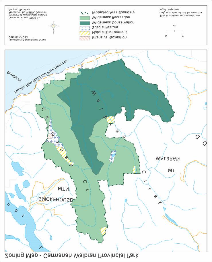
4 Impacts from adjacent land uses in the Walbran valley (edge effects, water quality, blow down risk, migratory routes, island ecosystem effects, potential slides etc.) Impacts of increased eco-tourism on the park s natural, cultural and recreation values Lack of awareness of park boundaries and values. Inappropriate recreational activities in sensitive areas Limited multi-day hiking experiences as a result of trail closures Impact of fishing and adjacent land uses on fish populations Work with MOF and Timberwest in Fletcher Falls and bite area to resolve management issues arising from blow down and access development in the area. Work with MOF and forest companies to protect park values during forest development. Continue to work with volunteers and eco-tourism operators to develop volunteer operating agreements, stewardship protocols and permits to manage and protect the park s values. Continue to monitor vegetation near viewing platforms. Identify park boundaries through signing at high profile locations throughout the park and by marking boundaries where appropriate. Develop a public awareness strategy to ensure the protection of these internationally significant natural values. Using an inventory of sensitive areas, ensure trails are located to minimize impact on sensitive features. Monitor levels and types of recreational use to ensure impacts to park values are minimized. Investigate future needs for facilities and interpretation information while undertaking the management plan to allow for appropriate recreation activities in the park. Work with the Fish and Wildlife Science and Allocation Section of the Ministry of Water, Land and Air Protection and Fisheries and Oceans Canada to monitor fish populations and ensure their viability. Zoning Intensive Recreation Zone covers the parking lot, camping and day use area at the main entrance to the park in the lower Carmanah, which represents an area of approximately 31hectares, or less than 0.2% of the park. The objective of this zone is to provide a variety of readily accessible, facility-oriented outdoor recreation opportunities. Natural Environment Zone covers the other three access points in the upper Carmanah, upper Walbran, the bite in mid Walbran and an area along the west side of Carmanah Creek. This represents an area of approximately 310 hectares, or 2 % of the park. The purpose of this zone is to protect scenic values and to provide for recreational opportunities in a largely undisturbed natural environment. A higher number of visitors are expected at these sites. Special Feature Zone covers two wet land areas -- along the west side of Carmanah Creek and a lake (Anderson Lake) and wetland area in the Walbran watershed. This represents an area of approximately 317 hectares or 2% of the park. The objective of this zone is to protect and present significant natural or cultural values given their special character, fragility and heritage values. Wilderness Conservation Zone represents the two intact watersheds of Cullite and Logan Creek and a portion of the lower Walbran watershed, an area of approximately 7,380 hectares or 45% of the park. The objective of this zone is to protect a remote, undisturbed natural landscape and to provide unassisted backcountry recreation opportunities dependent on a 4
5 pristine environment where no motorized activities are allowed. These watersheds will be left completely untouched with no active promotion of recreation activity within the zone. Wilderness Recreation Zone covers the remainder of the park, an area of approximately 8412 hectares or 51% of the park. The objective of this zone is to protect scenic values and to provide backcountry recreation opportunities in a pristine wilderness setting where air access may be permitted to designated sites. It is designed for large natural areas where ecological processes are uninfluenced by human activity, and where there is a low level of use confined to specific primitive facilities, which are not generally visited on a day use basis. Trails and minimal facilities that support the backcountry recreation use may be developed, while minimizing use impacts on the wildlife and wilderness values of the area. 5
6 Conservation Representation The park represents 2% of B.C. s remaining old growth forest. - ecosection Carmanah Walbran Provincial Park contributes significantly (8.1%) to the representation of the Windward Island Mountains Ecosection which is 17.42% protected. Carmanah Walbran s contribution ranks 3 rd (behind Strathcona & Brooks Peninsula parks) out of 50 protected areas representing this ecosection. - biogeoclimatic subzone/variant Carmanah Walbran Provincial Park contributes significantly (10.32%) to the representation of the CWHvm1 variant which has 7% protected provincially. Carmanah Walbran s contribution ranks 3 rd (behind Strathcona Provincial Park & Fiordland Recreation Area) out of 57 protected areas representing this variant. Carmanah Walbran Provincial Park makes a small contribution of 1.9% to the representation of the CWHvm2 variant which has 8.7% protected provincially. Carmanah Walbran Provincial Park contributes minimally (0.41%) to the representation of the CWHvh1 variant which has 19.3% protected provincially. Special Features Rare/Endangered Values Scientific/Research Opportunities Three intact, completely unlogged watersheds in the park Cullite, August and Logan creek drainages. Contains some of the largest trees in Canada over 90 trees greater than 70 metres tall living for 800 years or more, the tallest of which is 96 metres ( Carmanah Giant by Carmanah Creek tallest tree in Canada). A cedar/spruce old growth stand at Anderson Lake is of note as well. Diverse flora and fauna associated with undisturbed ecosystems. Numerous small lakes with diverse aquatic communities are important special features. Kokanee trout in Anderson Lake, anadromous steelhead and salmon in Walbran Creek. Nesting territory for the red-listed marbled murrelet and northern goshawk, laingi subspecies. Blue-listed nodding semaphore grass, coastal cutthroat trout, Dolly Varden char, and probable breeding habitat for the northern pygmy-owl, swarthy subspecies. Canopy studies related to old growth forests have been conducted since the early 1990s. 6
7 Representation backcountry destination travel corridor local recreation Special Opportunities Education/Interpretation Opportunities Recreation Park presents significant day and multi-day opportunities, international and regional interest. Environmentally-aware tourists (local, regional and international) as well as organized hiking groups, researchers and students are attracted to the old growth in Carmanah Walbran Provincial Park. Proximity to the population of southern Vancouver Island. Local day -use and multi-day recreational opportunities. High inspirational/spiritual values. Potential egress from the West Coast Trail to particular feature points in the Carmanah and Walbran valleys. Potential self-guided interpretative trail around Sitka spruce. High media/public interest and opportunities for visitor information/education and apprec iation of natural values. Cultural Heritage Representation Special Feature Unknown at this time. First Nations sites exist in Pacific Rim National Park and lands to the west and north. Possible Culturally Modified Trees (CMT) Other Management Considerations Other Designations Relationship to other PAs Co-operative Management Arrangements Partnerships Important Bird Area (IBA) site for breeding marbled murrelets called the Carmanah Walbran Forest site. The IBA program is an international program that identifies and supports the protection of lands having special bird habitats. Part of a system of protected areas on Vancouver Island. Adjacent to Pacific Rim National Park Reserve West Coast Trail unit. Two stewardship agreements: Carmanah Forestry Society, BC Pathways for construction and maintenance of trails. 7
8 Vulnerability Relationship to other Strategies Invasive species, increased use could result in loss of values, sensitive ecosystem and soils do not withstand high use when wet, spruce roots close to surface are easily damaged from hiking. Potential adverse effects of logging adjacent to the park boundary especially in the vicinity of the low-intensity area in the mid-walbran watershed. Original Carmanah Pacific Provincial Park was expanded from recommendations of the Vancouver Island Land Use Plan to create Carmanah Walbran Provincial Park Area: 16,450 hectares Date of establishment: March 13,
9 9
MARBLE RIVER PROVINCIAL PARK
 MARBLE RIVER PROVINCIAL PARK PURPOSE STATEMENT AND ZONING PLAN March 2003 MARBLE RIVER PROVINCIAL PARK Purpose Statement and Zoning Plan Primary Role The primary role of Marble River Park is to protect
MAIN LAKE PROVINCIAL PARK
 MAIN LAKE PROVINCIAL PARK PURPOSE STATEMENT AND ZONING PLAN March 2003 MAIN LAKE PROVINCIAL PARK Purpose Statement and Zoning Plan Primary Role The primary role of Main Lake Park is to protect a biologically
VARGAS ISLAND PROVINCIAL PARK
 VARGAS ISLAND PROVINCIAL PARK PURPOSE STATEMENT AND ZONING PLAN February 2003 VARGAS ISLAND PROVINCIAL PARK Purpose Statement and Zoning Plan Primary Role The primary role of Vargas Island Park is to protect
BLANKET CREEK PROVINCIAL PARK
 BLANKET CREEK PROVINCIAL PARK PURPOSE STATEMENT AND ZONING PLAN February 2003 BLANKET CREEK PROVINCIAL PARK Purpose Statement and Zoning Plan Primary Role The primary role of Blanket Creek Park is to maintain
OCTOPUS ISLANDS PROVINCIAL PARK
 OCTOPUS ISLANDS PROVINCIAL PARK PURPOSE STATEMENT AND ZONING PLAN February 2003 OCTOPUS ISLANDS PROVINCIAL PARK Purpose Statement and Zoning Plan Primary Role The primary role of Octopus Islands Park is
SPECTACLE LAKE PROVINCIAL PARK PURPOSE STATEMENT AND ZONING PLAN
 SPECTACLE LAKE PROVINCIAL PARK PURPOSE STATEMENT AND ZONING PLAN August 2003 1 SPECTACLE LAKE PROVINCIAL PARK Purpose Statement and Zoning Plan Primary Role The primary role of Spectacle Lake Park is to
SANTA-BOCA PROVINCIAL PARK
 SANTA-BOCA PROVINCIAL PARK PURPOSE STATEMENT AND ZONING PLAN March 2003 SANTA-BOCA PROVINCIAL PARK Purpose Statement and Zoning Plan Primary Role The primary role of Santa-Boca Park is to provide marine-based
SLIM CREEK PROVINCIAL PARK
 SLIM CREEK PROVINCIAL PARK PURPOSE STATEMENT AND ZONING PLAN March 2003 1 Slim Creek Provincial Park Purpose Statement and Zoning Plan Slim Creek Provincial Park is located along Highway 16, approximately
BROUGHTON ARCHIPELAGO PROVINCIAL PARK
 BROUGHTON ARCHIPELAGO PROVINCIAL PARK PURPOSE STATEMENT AND ZONING PLAN March 2003 BROUGHTON ARCHIPELAGO PROVINCIAL PARK Purpose Statement and Zoning Plan Primary Role The primary role is to contribute
EPPER PASSAGE PROVINCIAL PARK PURPOSE STATEMENT AND ZONING PLAN
 EPPER PASSAGE PROVINCIAL PARK PURPOSE STATEMENT AND ZONING PLAN August 2003 1 EPPER PASSAGE PROVINCIAL PARK Purpose Statement and Zoning Plan Primary Role The primary role of Epper Passage Park is to protect
ARCTIC PACIFIC LAKES PROVINCIAL PARK
 ARCTIC PACIFIC LAKES PROVINCIAL PARK PURPOSE STATEMENT AND ZONING PLAN March 2003 ARCTIC PACIFIC LAKES PROVINCIAL PARK Purpose Statement and Zoning Plan Located 90 km northeast of Prince George in the
FINGER-TATUK PROVINCIAL PARK
 FINGER-TATUK PROVINCIAL PARK PURPOSE STATEMENT AND ZONING PLAN March 2003 FINGER-TATUK PROVINCIAL PARK Purpose Statement and Zoning Plan Finger-Tatuk Provincial Park is 17,151 ha in size. It includes the
D IRECTION S TATEMENT
 Vancouver Island Region M ANAGEMENT D IRECTION S TATEMENT September 2003 for Lower Nimpkish Provincial Park Ministry of Water, Land and Air Protection Environmental Stewardship Lower Nimpkish Provincial
NECHAKO CANYON PROTECTED AREA
 NECHAKO CANYON PROTECTED AREA PURPOSE STATEMENT AND ZONING PLAN March 2003 1 Nechako Canyon Protected Area Purpose Statement and Zoning Plan The Nechako Canyon Protected Area (1,246 hectares) is located
Kwadacha Wilderness Provincial Park and Kwadacha Addition (Kwadacha Recreation Area) Purpose Statement and Zoning Plan
 Purpose Statement and Zoning Plan") Kwadacha Wilderness Provincial Park and Kwadacha Addition (Kwadacha Recreation Area) Purpose Statement and Zoning Plan Located in a remote area of the northern interior of BC, this large park straddles
Kwadacha Wilderness Provincial Park and Kwadacha Addition (Kwadacha Recreation Area) Purpose Statement and Zoning Plan Located in a remote area of the northern interior of BC, this large park straddles
SUGARBOWL-GRIZZLY DEN PROVINCIAL PARK AND SUGARBOWL-GRIZZLY DEN PROTECTED AREA Purpose Statement and Zoning Plan
 SUGARBOWL-GRIZZLY DEN PROVINCIAL PARK AND SUGARBOWL-GRIZZLY DEN PROTECTED AREA Purpose Statement and Zoning Plan Located one hour east of Prince George on Highway 16, Sugarbowl-Grizzly Den Provincial Park
KOOTENAY LAKE PROVINCIAL PARK (MIDGE CREEK SITE)
") KOOTENAY LAKE PROVINCIAL PARK (MIDGE CREEK SITE) PURPOSE STATEMENT AND ZONING PLAN February 2003 Approved by: KOOTENAY LAKE PROVINCIAL PARK (Midge Creek Site) Purpose Statement and Zoning Plan Primary
KOOTENAY LAKE PROVINCIAL PARK (MIDGE CREEK SITE) PURPOSE STATEMENT AND ZONING PLAN February 2003 Approved by: KOOTENAY LAKE PROVINCIAL PARK (Midge Creek Site) Purpose Statement and Zoning Plan Primary
BELLHOUSE PROVINCIAL PARK
 BELLHOUSE PROVINCIAL PARK PURPOSE STATEMENT AND ZONING PLAN March 2003 1 BELLHOUSE PROVINCIAL PARK Purpose Statement and Zoning Plan Primary Role The primary role of Bellhouse Provincial Park is to protect
ONE ISLAND LAKE PROVINCIAL PARK Purpose Statement and Zoning Plan
 ONE ISLAND LAKE PROVINCIAL PARK Purpose Statement and Zoning Plan Primary Role The primary role of One Island Lake Provincial Park is to provide recreational opportunities to regional and residential area
INLAND LAKE PROVINCIAL PARK
 INLAND LAKE PROVINCIAL PARK PURPOSE STATEMENT AND ZONING PLAN December 2002 INLAND LAKE PROVINCIAL PARK Purpose Statement and Zoning Plan Primary Role The primary role of Inland Lake Park is the protection
OMINEACA PROVINCIAL PARK
 OMINEACA PROVINCIAL PARK AND PROTECTED AREA PURPOSE STATEMENT AND ZONING PLAN March 2003 OMINECA PROVINCIAL PARK AND PROTECTED AREA Purpose Statement and Zoning Plan Omineca Park and Omineca Protected
HEATHER-DINA LAKES PROVINCIAL PARK
 HEATHER-DINA LAKES PROVINCIAL PARK PURPOSE STATEMENT AND ZONING PLAN March 2003 HEATHER-DINA LAKES PROVINCIAL PARK Purpose Statement and Zoning Plan Heather-Dina Lakes Provincial Park is located 25 km
Ed Bird Estella Lakes Provincial Park Purpose Statement and Zoning Plan
 Ed Bird Estella Lakes Provincial Park Purpose Statement and Zoning Plan Ed Bird Estella Lakes Provincial Park is situated at the most northern tip of Williston Lake, 3 km from Tsay Kay Dene and 67 km south
HOLE IN THE WALL PROVINCIAL PARK
 HOLE IN THE WALL PROVINCIAL PARK PURPOSE STATEMENT AND ZONING PLAN Peace Region 2006 Approved by: Andy Ackerman, Regional Manager Environmental Stewardship Division Peace Region Date: 2006 Nancy Wilkin
BURGES JAMES GADSDEN PROVINCIAL PARK PURPOSE STATEMENT AND ZONING PLAN
 BURGES JAMES GADSDEN PROVINCIAL PARK PURPOSE STATEMENT AND ZONING PLAN February 2003 BURGES JAMES GADSDEN PROVINCIAL PARK Purpose Statement and Zoning Plan Primary Role The primary role of Burges James
Muscovite Lakes Provincial Park Purpose Statement and Zoning Plan
 Muscovite Lakes Provincial Park Purpose Statement and Zoning Plan Muscovite Lakes Provincial Park is a 5,708-hectare park located on the western shore of Williston Reservoir, approximately 135 kilometres
SHUSWAP LAKE MARINE PROVINCIAL PARK
 SHUSWAP LAKE MARINE PROVINCIAL PARK Purpose Statement and Zoning Plan The primary role of the Shuswap Lake Marine Provincial Park is to provide a system of sites for marine overnight and day use of Shuswap
STONE MOUNTAIN PROVINCIAL PARK Purpose Statement and Zoning Plan
 1 STONE MOUNTAIN PROVINCIAL PARK Purpose Statement and Zoning Plan Stone Mountain Provincial Park is situated 140 km west of Fort Nelson at Kilometre 595 of the Alaska Highway. The 25 690 ha park is located
Stuart River Provincial Park Purpose Statement and Zoning Plan
 Stuart River Provincial Park Purpose Statement and Zoning Plan Stuart River Provincial Park protects three-quarters of the 110 kilometer long Stuart River corridor between Stuart Lake and the Nechako River.
Yard Creek Provincial Park. Management Plan
 Yard Creek Provincial Park Management Plan Draft January 2010 Yard Creek Provincial Park Management Plan Approved by: telàlsemkin/siyam/chief Scott Benton Bill Williams Squamish Executive Director ation
Fraser River Provincial Park Purpose Statement and Zoning Plan
 Fraser River Provincial Park Purpose Statement and Zoning Plan Fraser River Provincial Park is located on the west bank of the Fraser River, approximately 35 km south of Prince George. This 4,899 ha Protected
SMITH RIVER FORT HALKETT PROTECTED AREA
 SMITH RIVER FORT HALKETT PROTECTED AREA PURPOSE STATEMENT AND ZONING PLAN Peace Region 2006 Approved by: Andy Ackerman, Regional Manager Environmental Stewardship Division Peace Region Date: 2006 Nancy
MILLIGAN HILLS PROVINCIAL PARK
 MILLIGAN HILLS PROVINCIAL PARK PURPOSE STATEMENT AND ZONING PLAN Peace Region 2006 Approved by: Andy Ackerman, Regional Manager Environmental Stewardship Division Peace Region Date: 2006 Nancy Wilkin Assistant
MANAGEMENT DIRECTION STATEMENT June, 1999
 Garibaldi/Sunshine Coast District MAAGEMET DIRECTIO STATEMET June, 1999 for Homathko Estuary Provincial Park Ministry of Environment Lands and Parks BC Parks Division TABLE OF COTETS Introduction...1
2.0 PARK VISION AND ROLES
 2.0 PARK VISION AND ROLES 2.1 Significance in the Protected Area System Marble Range and Edge Hills provincial parks protect 6.8% of the Pavillion Ranges Ecosection, which is located in the Southern Interior
MONTAGUE HARBOUR MARINE PROVINCIAL PARK
 MONTAGUE HARBOUR MARINE PROVINCIAL PARK PURPOSE STATEMENT AND ZONING PLAN March 2003 1 MONTAGUE HARBOUR MARINE PROVINCIAL PARK Purpose Statement and Zoning Plan Primary Role The primary role of Montague
MANAGEMENT DIRECTION STATEMENT March 2003
 Skeena Region MAAGEMET DIRECTIO STATEMET March 2003 for Meziadin Lake Provincial Park Ministry of Water, Land and Air Protection Environmental Stewardsh Division This page left blank on purpose ii Table
THUNDER HILL PROVINCIAL PARK
 THUNDER HILL PROVINCIAL PARK PURPOSE STATEMENT AND ZONING PLAN February 2003 Approved by: THUNDER HILL PROVINCIAL PARK Purpose Statement and Zoning Plan Primary Role The primary role of Thunder Hill Provincial
D IRECTION S TATEMENT
 Vancouver Island Region M AAGEMET D IRECTIO S TATEMET September 2003 for Woss Lake Provincial Park Ministry of Water, Land an Air Protection Environmental Stewardship Division Woss Lake Provincial Park
ANAGEMENT P LAN. July for Chilliwack Lake Park & Chilliwack River Ecological Reserve. Ministry of Environment, Lands and Parks BC Parks Division
 M ANAGEMENT P LAN July 2000 for Chilliwack Lake Park & Chilliwack River Ecological Reserve Ministry of Environment, Lands and Parks BC Parks Division Chilliwack Lake Provincial Park & Chilliwack River
Appendix A BC Provincial Parks System Goals
 Appendix A BC Provincial Parks System Goals The British Columbia Provincial Parks System has two mandates: To conserve significant and representative natural and cultural resources To provide a wide variety
Wrinkly Face Provincial Park Purpose Statement and Zoning Plan
 Wrinkly Face Provincial Park Purpose Statement and Zoning Plan Wrinkly Face Provincial Park is located about 16 km northeast of Winfield. The park is accessed via a logging road off the Beaver Main Forest
MANAGEMENT DIRECTION STATEMENT
 Lower Mainland District MAAGEMET DIRECTIO STATEMET January 2001 for Liumchen Ecological Reserve Ministry of Environment Lands and Parks BC Parks Division Table of Contents Page Introduction... 1 Purpose
Outdoor Recreation Opportunities Management
 Outdoor Recreation Opportunities Management Introduction A major role of a management plan is to provide direction regarding the types of recreation that are appropriate, and to outline the steps that
OKANAGAN LAKE PROVINCIAL PARK Purpose Statement and Zoning Plan
 1 OKANAGAN LAKE PROVINCIAL PARK Purpose Statement and Zoning Plan Okanagan Lake Park is a 98 hectare area fronting on Okanagan Lake. The park straddles Highway 97 midway between Summerland and Peachland.
MANAGEMENT DIRECTION STATEMENT March 2003
 Skeena Region MAAGEMET DIRECTIO STATEMET March 2003 for Lava Forks Provincial Park Ministry of Water, Land and Air Protection Environmental Stewardshi Division This management direction statement was
MANAGEMENT DIRECTION STATEMENT
 Skeena District MAAGEMET DIRECTIO STATEMET July, 2000 for Driftwood Canyon Provincial Park Ministry of Environment Lands and Parks BC Parks Division i Table of Contents Driftwood Canyon Park Approvals
Outdoor Recreation Opportunities Management
 Outdoor Recreation Opportunities Management Introduction The natural features of Height of the Rockies and Elk Lakes provincial parks provide a wide variety of outdoor recreational activities. However,
MANAGEMENT DIRECTION STATEMENT June, 1999
 Thompson River District MANAGEMENT DIRECTION STATEMENT June, 1999 for Clearwater River Corridor (Addition to Wells Gray Park) Ministry of Environment Lands and Parks BC Parks Division ii Table of Contents
ANAGEMENT P LAN. February, for Elk Lakes and Height of the Rockies Provincial Parks. Ministry of Environment, Lands and Parks BC Parks Division
 M ANAGEMENT P LAN February, 1999 for Elk Lakes and Height of the Rockies Provincial Parks Ministry of Environment, Lands and Parks BC Parks Division Elk Lakes & Height of the Rockies Provincial Parks M
MANAGEMENT DIRECTION STATEMENT March 2003
 Skeena Region MAAGEMET DIRECTIO STATEMET March 2003 for Great Glacier Provincial Park Ministry of Water, Land an Air Protection Environmental Stewardship Division ii This management direction statement
Role of the Protected Area
 Role of the Protected Area Provincial and Regional Context Height of the Rockies and Elk Lakes provincial parks lie in southeastern British Columbia in the Rocky Mountains, about 85 km southwest of Calgary,
Whitemouth Falls Provincial Park. Draft Management Plan
 Whitemouth Falls Provincial Park Draft Management Plan Whitemouth Falls Provincial Park Draft Management Plan Table of Contents 1. Introduction... 3 2. Park History... 3 3. Park Attributes... 4 3.1 Natural...
MANAGEMENT DIRECTION STATEMENT June, 1999
 Thompson River District MANAGEMENT DIRECTION STATEMENT June, 1999 for Roche Lake Provincial Park Ministry of Environment Lands and Parks BC Parks Division Table of Contents I. Introduction A. Setting
MANAGEMENT DIRECTION STATEMENT March 2003
 Skeena Region MAAGEMET DIRECTIO STATEMET March 2003 for Craig Headwaters Protected Area Ministry of Water, Land and Air Protection Environmental Stewardshi Division This management direction statement
Numaykoos Lake Provincial Park. Management Plan
 Numaykoos Lake Provincial Park Management Plan 2 Numaykoos Lake Provincial Park Table of Contents 1. Introduction... 3 2. Background... 3 3. Park Purpose... 5 4. Park Management Guidelines... 6 Appendix...
Clearwater Lake Provincial Park. Draft Management Plan
 Clearwater Lake Provincial Park Draft Management Plan Clearwater Lake Provincial Park Draft Management Plan Table of Contents 1. Introduction... 3 2. Park History... 4 3. Park Attributes... 4 3.1 Location/Access...4
Pembina Valley Provincial Park. Draft Management Plan
 Pembina Valley Provincial Park Draft Management Plan 2 Pembina Valley Provincial Park Table of Contents 1. Introduction... 3 2. Park History... 3 3. Park Attributes... 3 3.1 Natural... 3 3.2 Recreational...
As outlined in the Tatshenshini-Alsek Park Management Agreement, park management will:
 Management Strategy General Strategy The priority management focus for the park is to ensure that its internationally significant natural, cultural heritage and recreational values are protected and that
Watchorn Provincial Park. Management Plan
 Watchorn Provincial Park Management Plan 2 Watchorn Provincial Park Table of Contents 1. Introduction... 3 2. Park History... 3 3. Park Attributes... 3 3.1 Natural... 4 3.2 Recreational... 4 3.3 Additional
Victor Lake Park. Management Plan
 Victor Lake Park Management Plan November 2012 Victor Lake Park Management Plan Approved by: Jeff Leahy, Regional Director Thompson Cariboo Region BC Parks March 28, 2012 Date Brian Bawtinheimer, Executive
5.0 OUTDOOR RECREATION OPPORTUNITIES AND MANAGEMENT
 5.0 OUTDOOR RECREATION OPPORTUNITIES AND MANAGEMENT 5.1 Introduction This section describes the range of recreational activities that currently take place in Marble Range and Edge Hills Parks, as well
Qwalímak/Upper Birkenhead Conservancy. Management Plan
 Qwalímak/Upper Birkenhead Conservancy Management Plan March 2012 Cover photo: Upper Birkenhead River Photo credit: Liz Scroggins Qwalímak/Upper Birkenhead Conservancy Management Plan Acknowledgements
NARRABEEN LAGOON SUMMIT am Wednesday, 13 April 2005 Warringah Council Chambers, 725 Pittwater Road, Dee Why.
 NARRABEEN LAGOON SUMMIT 9.15 9.30am Wednesday, 13 April 2005 Warringah Council Chambers, 725 Pittwater Road, Dee Why. NSW Minister for the Environment, the Hon. Bob Debus I am very pleased to be here to
APPENDIX. Alberta Land Stewardship Act AMENDMENTS TO THE SOUTH SASKATCHEWAN REGIONAL PLAN
 APPENDIX Alberta Land Stewardship Act AMENDMENTS TO THE SOUTH SASKATCHEWAN REGIONAL PLAN 1 All references to Alberta Environment and Sustainable Resource Development, Environment and Sustainable Resource
Sand Lakes Provincial Park. Draft Management Plan
 Sand Lakes Provincial Park Draft Management Plan 2 Sand Lakes Provincial Park Table of Contents 1. Introduction... 3 2. Background... 3 3. Park Purpose... 5 4. Park Management Guidelines... 6 Appendix...
Hudson Bay Lowlands Proposed Protected Areas
 Hudson Bay Lowlands Proposed Protected Areas Hudson Bay Lowlands Proposed Protected Areas The Protected Areas Initiative has identified portions of the Hudson Bay Lowlands region that have significant
MANAGEMENT DIRECTION STATEMENT March 2003
 Skeena Region MAAGEMET DIRECTIO STATEMET March 2003 for Lowe Inlet Marine Provincial Park Ministry of Water, Land and Air Protection Environmental Stewardshi Division This page left blank on purpose
Davis Lake Provincial Park ANAGEMENT P LAN. (Draft Report Under Review) Prepared by Regional Operations Lower Mainland North Vancouver, BC
 Prepared by Regional Operations Lower Mainland North Vancouver, BC") Davis Lake Provincial Park M ANAGEMENT P LAN (Draft Report Under Review) Prepared by Regional Operations Lower Mainland North Vancouver, BC M ANAGEMENT P LAN April 2002 for Davis Lake Provincial Park Ministry
Davis Lake Provincial Park M ANAGEMENT P LAN (Draft Report Under Review) Prepared by Regional Operations Lower Mainland North Vancouver, BC M ANAGEMENT P LAN April 2002 for Davis Lake Provincial Park Ministry
Birch Point Provincial Park. Management Plan
 Birch Point Provincial Park Management Plan 2 Birch Point Provincial Park Table of Contents 1. Introduction... 3 2. Park History... 3 3. Park Attributes... 4 3.1 Natural... 4 3.2 Recreational... 4 4. Park
Sasagiu Rapids Provincial Park. Draft Management Plan
 Sasagiu Rapids Provincial Park Draft Management Plan 2 Sasagiu Rapids Provincial Park Table of Contents 1. Introduction... 3 2. Background and Park Attributes... 3 2.1 Park History.... 3 2.2 Natural Features...
Criddle/Vane Homestead Provincial Park. Management Plan
 Criddle/Vane Homestead Provincial Park Management Plan 2 Criddle/Vane Homestead Provincial Park Table of Contents 1. Introduction... 3 2. Park History.... 3 3. Park Attributes.... 4 3.1 Natural.... 4 3.2
INFORMATION NOTICE 15-2 Limited & Excluded Lands
 INFORMATION NOTICE 15-2 Limited & Excluded Lands Schedule 1 (Land Description) of onshore petroleum Agreements issued by the Department of Energy details the total hectares calculated. Total hectares are
Pinellas County Environmental Lands
 Pinellas County Environmental Lands In addition to traditional parks and recreation facilities, Pinellas County owns and manages a system of environmental lands that provides specialized resource-based
Steps in the Management Planning Process
 Steps in the Management Planning Process Developing a management plan for Kalamalka Lake Park will follow a multi-stage process. The planning process for this park is currently in the Draft Management
Criddle/Vane Homestead Provincial Park. Draft Management Plan
 Criddle/Vane Homestead Provincial Park Draft Management Plan 2 Criddle/Vane Homestead Provincial Park Table of Contents 1. Introduction... 3 2. Park History.... 3 3. Park Attributes.... 3 3.1 Natural....
The Frank Church River of No Return Wilderness
 ALLIANCE FOR WILDERNESS EDUCATION AND STEWARDSHIP PO Box 2667, Bellingham, WA 98227-2667 Tele: 360-927-1804 Fax: 360-527-9679 bradt@wildernessalliance.org www.wildernessalliance.org STEWARDS OF AMERICA
Fred Antoine Park. Management Plan. Final Public Review Draft
 Fred Antoine Park Management Plan Final Public Review Draft March 2016 Fred Antoine Park Management Plan Approved by: Jeff Leahy Regional Director Thompson Cariboo Region BC Parks Date Brian Bawtinheimer
Finn Creek Park. Management Direction Statement Amendment
 Finn Creek Park Management Direction Statement Amendment November 2013 Management Direction Statement Amendment Approved by: Jeff Leahy Regional Director, Thompson Cariboo BC Parks November 12, 2013 Date
MANAGEMENT DIRECTION STATEMENT November 1999
 Garibaldi/Sunshine Coast District MAAGEMET DIRECTIO STATEMET ovember 1999 for Upper Lillooet Provincial Park Ministry of Environment Lands and Parks BC Parks Division UPPER LILLOOET PROVICIAL PARK APPROVALS
Mackinnon Esker Ecological Reserve. Management Plan
 Mackinnon Esker Ecological Reserve Management Plan March 2017 Cover Page Photo Credit: Rob Bell This document replaces the direction provided in the Carp Lake Provincial Park and Protected Area and Mackinnon
Preferred Recreation Recommendations Stemilt-Squilchuck Recreation Plan March 2018
 Preferred Recreation Recommendations Stemilt-Squilchuck Recreation Plan March 2018 Below are the recommended recreation ideas and strategies that package together the various recreation concepts compiled
Natural and Cultural Values and Their Management...18
 Skagit Valley Provincial Park Management Plan Table of Contents Plan Highlights...4 Introduction...5 The Management Planning Process...5 Background Summary...6 Relationship to Other Land Use Planning...8
Quesnel Lake Park. Management Plan
 Quesnel Lake Park Management Plan December 2015 Quesnel Lake Park Management Plan Approved by: December 14, 2015 Peter Weilandt A/Regional Director Thompson Cariboo Region BC Parks Date December 14, 2015
Proposed National Marine Conservation Area Reserve Southern Strait of Georgia PROJECT UPDATE Spring 2012
 Proposed National Marine Conservation Area Reserve Southern Strait of Georgia PROJECT UPDATE Spring 2012 National marine conservation areas (NMCAs) are established to protect, conserve and present examples
Marchand Provincial Park. Management Plan
 Marchand Provincial Park Management Plan 2 Marchand Provincial Park Table of Contents 1. Introduction... 3 2. Park History... 3 3. Park Attributes... 4 3.1 Natural... 4 3.2 Recreational... 4 3.3 Additional
Conservation Area Management Statement
 Conservation Area Management Statement Miller Creek Wildlife Area Resolution #: Approval: Issue Date: Date of Last Revision: Table of Contents 1. Purpose....... 1 2. Property Description...... 1 2.1. Legal
PROUDLY BRINGING YOU CANADA AT ITS BEST. Management Planning Program NEWSLETTER #1 OCTOBER, 2000
 PROUDLY BRINGING YOU CANADA AT ITS BEST VUNTUT NATIONAL PARK Management Planning Program NEWSLETTER #1 OCTOBER, 2000 INTRODUCTION This newsletter launches the development of the first management plan for
Brackendale Eagles Park Baynes Island Ecological Reserve Tantalus Park. Management Plan. February Squamish Nation
 Brackendale Eagles Park Baynes Island Ecological Reserve Tantalus Park Brackendale Eagles Park Baynes Island Ecological Reserve Tantalus Park February 2012 Squamish Nation This document replaces the direction
ANAGEMENT. LAN November, 1996
 M ANAGEMENT P LAN November, 1996 for Paul Lake Provincial Park Ministry of Environment, Lands and Parks BC Parks Department Paul Lake Provincial Park M ANAGEMENT P LAN Prepared by BC Parks Kamloops Area
MANAGEMENT DIRECTION STATEMENT
 Skeena District MAAGEMET DIRECTIO STATEMET August 2000 for Driftwood Extension to Babine Mountains Park Ministry of Environment Lands and Parks BC Parks Division This management direction statement was
P LAN A MENDMENT June 2001
 M ASTER P LAN A MENDMENT June 2001 for Strathcona Park Strathcona Park M ASTER P LAN A MENDMENT BC Parks Strathcona District National Library of Canada Cataloguing in Publication Data BC Parks. Strathcona
Adventure Tourism Management Plan. Adventure Tourism Intensive Use Sites MANAGEMENT PLAN
 Adventure Tourism Intensive Use Sites MANAGEMENT PLAN ACCEPTED BY: FILES #: 1413906 1413905 LICENSES #: 112857 112905 DATE: April 25, 2018 SIGNED on behalf of HER MAJESTRY THE QUEEN IN THE RIGHT OF THE
$850,000 Awarded to 20 Organizations
 $850,000 Awarded to 20 Organizations The Conservation Alliance is pleased to fund the following organizations to support their efforts to protect wild lands and waterways for their habitat and recreation
Michipicoten Island Regional Plan
 Michipicoten Island Regional Plan This is one of twenty Regional Plans that support implementation of the Lake Superior Biodiversity Conservation Strategy (Strategy). The Strategy, prepared and overseen
Mackinnon Esker Ecological Reserve Draft - Management Plan
 Mackinnon Esker Ecological Reserve Draft - Management Plan May 2011 Photo Credit: This document replaces the direction provided in the Carp Lake Provincial Park and Protected Area and Mackinnon Esker Ecological
WORKSHEET 1 Wilderness Qualities or Attributes Evaluating the Effects of Project Activities on Wilderness Attributes
 WORKSHEET 1 Wilderness Qualities or Attributes Evaluating the Effects of Project Activities on Wilderness Attributes Date: 3/7/2017 Roadless Area: Ruby South Description of Project Activity or Impact to
Beaver Creek Provincial Park. Management Plan
 Beaver Creek Provincial Park Management Plan 2 Beaver Creek Provincial Park Table of Contents 1. Introduction... 3 2. Park History... 3 3. Park Attributes... 4 3.1 Natural... 4 3.2 Recreational... 4 4.
Pinawa Provincial Park. Draft Management Plan
 Pinawa Provincial Park Draft Management Plan Pinawa Provincial Park Draft Management Plan Table of Contents 1. Introduction... 3 2. Park History... 3 3. Park Attributes... 4 3.1 Natural... 4 3.2 Recreational...
A summary of Draft Makara Peak Mountain Bike Park Master Plan
 A summary of Draft Makara Peak Mountain Bike Park Master Plan OVEMBER 216 Image: Peter Marshall 2 3 Introduction Since it was established in 1998, the Makara Peak Mountain Bike Park (Makara Peak) has grown