Vilas County Outdoor Recreation Plan
|
|
|
- Elisabeth Patterson
- 5 years ago
- Views:
Transcription


1 Vilas County Outdoor Recreation Plan Also covering the municipalities within Vilas County Effective January 1, 2019 to December 31, 2023 Prepared by: North Central Wisconsin Regional Planning Commission
 Marvin A Anderson Dist. 11) Chuck Hayes Dist. 2) Carolyn Ritter Dist. 12) Charles Rayala, Jr. Dist. 3) Walter Maciag Dist. 13) Vernon Wiggenhauser Dist. 4) Art Kunde Dist. 14) Jay Verhulst Dist.")
2 Vilas County Board of Supervisors County Board Chair Ronald De Bruyne Dist. 7) Vice-Chair Gerald Burkett Dist. 19) Second Vice-Chair Steven Doyen Dist. 15) Willy Otterpohl Dist. 1) Marvin A Anderson Dist. 11) Chuck Hayes Dist. 2) Carolyn Ritter Dist. 12) Charles Rayala, Jr. Dist. 3) Walter Maciag Dist. 13) Vernon Wiggenhauser Dist. 4) Art Kunde Dist. 14) Jay Verhulst Dist. 5) Daniel Swiecichowski Dist. 16) Erv Teichmiller Dist. 6) Holly Tomlanovich Dist. 17) Tom Maulson Dist. 8) Ronald Kressin Dist. 18) Robert Hanson Dist. 9) Todd Achterberg Dist. 20) Alden B Bauman Dist. 10) Kim Simac Dist. 21) Vilas County Forestry, Recreation & Land Committee Steve Doyen, Chair Holly Tomlanovich, Vice-Chair Art Kunde Jay Verhulst Ron De Bruyne Staff for this plan John Gagnon, CF, Vilas County Forest Administrator Dale Mayo, Vilas County Recreation Administrator Fred Heider, AICP, NCWRPC Planner DRAFT: October 2018 This plan was prepared under the direction of the Vilas County Forestry, Recreation, & Land Department by the North Central Wisconsin Regional Planning Commission. For more information contact: NORTH CENTRAL WISCONSIN REGIONAL PLANNING COMMISSION 210 MCCLELLAN STREET, SUITE 210 WAUSAU, WI Phone:
3 ABSTRACT TITLE: VILAS COUNTY OUTDOOR RECREATION PLAN Effective January 1, 2019 to December 31, 2023 SUBJECT: This report assesses the existing recreation system in Vilas County, identifies recreation needs based upon public input and recreation standards, sets forth goals and objectives to be used as guidelines in formulating recreation plans, and establishes recommendations for improving the recreation system over the next five years. Submission of this report to the Wisconsin Department of Natural Resources establishes eligibility for the County and local units of government for a variety of Federal and State Aids. Non-profit groups, foundations, and the general public may also use this document to coordinate their own private efforts for developing outdoor recreation facilities. DATE: DRAFT: October 2018 AGENCY: CONTACT: Vilas County Forestry, Recreation, and Land Department Vilas County Courthouse 330 Court Street Eagle River, Wisconsin Dale Mayo, Vilas County Recreation Administrator
4 TABLE OF CONTENTS CHAPTERS: 1. INTRODUCTION Purpose Statutory Base For This Plan Plan Components Reference Plans DESCRIPTION OF VILAS COUNTY Physical Characteristics Social Characteristics COUNTY RECREATION FACILITIES Introduction County Parks County Forest County Camping Areas County Shooting Range County Picnic Areas County Swimming Beaches County Public Access Points to Water Bodies OUTDOOR RECREATION NEEDS ASSESSMENT Introduction Public Participation Needs Driven Park Planning GOALS AND OBJECTIVES RECOMMENDATIONS & CAPITAL IMPROVEMENTS Introduction General County Recommendations County Facility Capital Improvements Local Government Facility Capital Improvements FEDERAL, STATE, AND LOCAL GOVERNMENT MANAGED OUTDOOR RECREATION FACILIITES Introduction Linear Facilities Points Of Interest City & Town Facilities City of Eagle River Town of Arbor Vitae Town of Boulder Junction Vilas County North Central Wisconsin Outdoor Recreation Plan Regional Planning Commission
5 Town of Cloverland Town of Conover Town of Lac du Flambeau Town of Land O Lakes Town of Lincoln Town of Manitowish Waters Town of Phelps Town of Plum Lake Town of Presque Isle Town of St. Germain Town of Washington Town of Winchester 7.5 School District Facilities State Facilities Forested Lands Not State Owned Federal Facilities Private Outdoor Recreation Facilities IMPLEMENTATION STRATEGIES PROVISIONS FOR UPDATING ATTACHMENTS: A. Online Survey Results Summary B. Park Design and Location Criteria C. Facility Development Standards D. Federal and State Outdoor Recreation Funding Programs E. Route / Trail Interaction MAP F. Great Headwaters Trails MAP Vilas County North Central Wisconsin Outdoor Recreation Plan Regional Planning Commission
6 Map 1 Map 2 Map 3 Map 4 Map 5 Map 6 Map 7 Map 8 MAPS: Recreational Facilities Countywide Bike/Ped Route and Trail Plan Vilas County Forest Forest Units White Squaw & Snipe Lake Units) Forest Units Pioneer Creek, Mud Minnow, & Langley Lake Units) Forest Units Decker Lake, Torch Lake, Heart Lake, Muskrat Creek, & Ski Hill Units) Forest Unit Deep Lake Unit) City of Eagle River Vilas County North Central Wisconsin Outdoor Recreation Plan Regional Planning Commission
7 Chapter 1 INTRODUCTION 1.1 Purpose The primary purpose of this recreation plan is to provide continued direction toward meeting the current and future recreation needs of the county. This is accomplished through an inventory and analysis of outdoor recreational facilities, and the establishment of recommendations to meet identified needs. Adoption of this plan by the Vilas County Board, and subsequent acceptance by the Wisconsin Department of Natural Resources WisDNR), will continue eligibility of the county for the Federal Land and Water Conservation Fund Program LWCF), Aids for the Acquisition and Development of Local Parks ADLP), Urban Green Space Program UGS) and Urban Rivers Grant Program URGP). Local government grant applications have a better chance of approval if they have an outdoor recreation plan. Individual communities may adopt this county plan by resolution to make it their own. The DNR reserves the right to suggest that a community create their own outdoor recreation plan separate from this county outdoor recreation plan. Non-profit groups, foundations, and the general public may also use this document to coordinate their own private efforts for developing outdoor recreation facilities. 1.2 Statutory Base For This Plan This comprehensive outdoor recreation plan CORP) was prepared pursuant to Wisconsin Statute Outdoor Recreation Program. This section serves to promote, encourage, coordinate, and implement a comprehensive long-range plan to acquire, maintain, and develop for public use, those areas of the state best adapted to the Plan title note: For purposes in this plan, the terms: outdoor recreation plan and comprehensive outdoor recreation plan are used interchangeably. development of a comprehensive system of state and local outdoor recreation facilities and services... Submission of this adopted ORP to the Wisconsin Department of Natural Resources establishes eligibility for the county and local units of government to apply for a variety of Federal and State Aids for outdoor recreation Chapter NR ), Wisconsin administrative code). Vilas County ORP NCWRPC Page 1
8 1.3 Plan Components This plan addresses outdoor recreation needs that are satisfied by the Vilas County Forestry, Recreation, and Land Department FRLD) maintained facilities. Other public facilities are also listed to provide a more complete view of all public facilities available in Vilas County. Background information on Vilas County was compiled to develop an understanding of the environmental and social characteristics of the county and their meaning for outdoor recreation. An inventory of existing recreational facilities exists in Chapter 3 of this plan. The existing recreation system was analyzed to determine current and potential future deficiencies through the year A combination of public survey compilation and standards analysis were utilized to define recreational and open space needs. Goals and objectives were created to guide the direction of recreational planning efforts within Vilas County. The recommendations are general strategies and five-year action programs for recreation facility development. A series of possible tools to aid implementation of these recommendations are set forth in the attachments. The plan concludes with a note on updating to insure that it remains relevant to the needs of the county over the entire five-year span. 1.4 Reference Plans Vilas County has been involved with outdoor recreation plans since 1972 when the local University of Wisconsin Extension Resource Agent compiled the County's first outdoor recreation plan. Later, the North Central Wisconsin Regional Planning Commission updated the plan for years , , , and since the plan. Additional plans and studies that affect outdoor recreation in Vilas County are referenced below: Vilas County Countywide Bike/Ped Route & Trail Plan, 2011 This plan is intended to guide the development of an interconnected bikeway and pedestrian system for Vilas County. This plan is a tool designed to make Vilas County more walkable and bikeable. Results of this plan include a bicycle trail and route map, and an implementation action plan. See Map 2. Vilas County Shared Use Route & Trail Study, 2018 This study provides guidance to assist governmental entities, route & trail interest groups and individual trail users within Vilas County in working together to plan, develop and maintain a comprehensive and sustainable route and trail network for diverse outdoor recreation. See map in Attachment E. Vilas County ORP NCWRPC Page 2
9 Vilas County Comprehensive Plan This plan was created according to the state comprehensive planning law Sec WI Stats) and is a compilation of historical data and community created goals, objectives, policies, and programs that will guide future planning and community decisions for a 20-year period. Comprehensive plans incorporate a 20-year vision and provide a rational basis for local land use decisions. The physical and social characteristics of Vilas County were taken from the comprehensive plan. Maps locating boat access points, and local parks were made from data gathered for the comprehensive plan. Vilas County Land & Water Resource Management Plan, The Vilas County Land & Water Conservation Committee developed this plan in The plan provides an inventory of the County s natural resources and a series of goals and objectives intended to improve and protect these resources in the future. Vilas County Forest Comprehensive Land Use Plan, The mission of the County Forest is to manage, conserve, and protect the forest resources on a sustainable basis for present and future generations. This 10-year plan was created under Sec WI Stats to manage the County Forest. This plan incorporates or references all county forest policies, pertinent county ordinances, planning documents, and needs and actions to occur from 2006 to 2020 that relate to managing the Vilas County Forest lands. North Central Wisconsin Regional Bicycle and Pedestrian Plan, 2018 The purpose of this 2018 plan is to recommend policies, programs, and facilities to improve the safety, viability, convenience, and attractiveness of bicycling and walking for transportation. This plan also serves to bridge the gap between local community planning and State plans, as well as fill in gaps where improvements for bicycling and/or walking end in local community plans, to create a regional network of safe walking and bicycling. Goals of the Regional Bicycle and Pedestrian Plan: Mobility The Trail System must enhance bicyclists ability to get around the Region including access to key destinations such as schools, parks, retail areas, and other public facilities. Functionality New off-road routes, improved existing street routes, signage and marking, and route promotion must be combined to function as a system that is easy and desirable to use. Safety Every bicyclist and pedestrian in the North Central Region deserves a system that is safe for travel. Vilas County ORP NCWRPC Page 3
10 Connectivity The Trail System must provide a seamless transportation system on multiple levels including; internally to all areas of a community; externally to outlying neighbors around the Region; and becoming a part of the bigger picture of a statewide trails network. State Trails Network Plan This 2001 document revised in 2003) clarifies a Wisconsin Department of Natural Resources WDNR) role and strategy in the provision of all types of trails. The plan identifies a series of potential trail corridors that would link existing trails, public lands, natural features, and communities. This statewide network of interconnected trails would be owned and maintained by municipalities, private entities, and partnerships of the two. Preserving transportation corridors, such as old rail lines, is specifically discussed as a very important strategy in the creation of recreational and alternative transportation corridors. Trails are shown on Map 1 Segment 15 Ashland to Rhinelander From Manitowish, a potential trail corridor extends southeast through Vilas County to the City of Rhinelander. The route includes abandoned rail corridors, roadways and existing trails in the Northern Highland American Legion State Forest. The segment in Iron County is an existing snowmobile trail. Iron County would like to cooperate with the state forest to repair bridges so the trail can be opened for bicycling. Part of this segment includes a proposed loop route on abandoned rail line from Manitowish to Woodruff. From Woodruff, the loop extends north to Boulder Junction and returns to Manitowish. In addition to abandoned rail line, the loop consists of Boulder Junction s community trail, roadways and/or existing forest trails. A spur connector to Sayner is also proposed using forest trails and/or low-use roadways. Continuing south, a route through Woodruff/Minocqua would connect with the Bearskin/Hiawatha State Trail. Segment 19 Langlade Co. to Michigan state line This abandoned rail corridor links the State of Michigan with the Mountain Bay Trail near Eland in Marathon County. It passes through a few state wildlife areas and some county forests. This corridor also links to the proposed Three Lakes to Rhinelander and Crandon to Tomahawk abandoned rail corridors, the Washburn to Rhinelander corridor at Monico and the Antigo to White Lake proposed corridor. The segment includes a loop to the Crandon to White Lake proposed corridor. The grade runs through portions of Langlade County Forest, the lake area around Kempster in Langlade County and the popular tourist areas of Three Lakes and Eagle River in Vilas County. Vilas County ORP NCWRPC Page 4
11 Statewide Comprehensive Outdoor Recreation Plan SCORP) NOTE: This plan is being updated in Every five years, the Wisconsin DNR publishes a SCORP as required by the Federal Land and Water Conservation Fund Act of At its core, this SCORP is used to help allocate federal funds equitably among local communities, but the document also transcends many levels of outdoor recreation discussion and policy. At the national level, this SCORP recognizes the America s Great Outdoors AGO) Initiative, which is based on the idea that the protection of the country s natural heritage is a non-partisan objective shared by all Americans. The AGO encourages state and local communities to develop local conservation and recreation initiatives. 2018: Much of the information presented in the Plan is still relevant, but some parts are out of date such as the America s Great Outdoors AGO) Initiative, which no longer has federal support. Development of the SCORP is underway, and there is a strong emphasis in this SCORP to gather detailed information about Wisconsin residents participation in 65 specific outdoor recreation activities. Data gathering has included an extensive mail survey and user interviews at state properties focused on understanding activities pursued, features and attributes that lead people to visit the properties, visitors satisfaction and travel-related spending. The State has also initiated a sub-project of the SCORP, the Recreation Opportunities Analysis ROA), to assess existing outdoor recreation opportunities, needs and priorities throughout the State. The goal of the project is to develop regional assessments that can directly inform the DNR s property master planning process in each of eight regions across the State. These assessments will be created from feedback at public input meetings held in each region. The DNR s goal is to complete the ROA for each of the eight regions by the summer of The resulting data will then be used to complete the SCORP by the end of Vilas County ORP NCWRPC Page 5
12 Wisconsin Land Legacy Report This report is a comprehensive inventory of the special places that will be critical to meet future conservation and outdoor recreation needs for the next fifty years. Some of the questions asked to guide creation of this report were: Which lands and waters remain unprotected that will be critical for conserving our plants and animals and their habitats? What gaps exist now and will likely emerge in the future) in providing abundant and satisfying outdoor recreation? How can we most effectively build upon the state's existing investment in protected lands to fill conservation and recreation gaps? What special places will our children and grandchildren wish we had protected? The study focused on identifying what of our state or regionally significant green infrastructure remains to be protected. The report recommends protection of these lands by using federal, state, and local funding opportunities; along with possibly creating new kinds of incentives for landowners, working to draft comprehensive plans, or offering different types of technical assistance. Each Vilas County Legacy Area is summarized below with 5 stars representing the highest level for that category: CN Chequamegon-Nicolet Nat l Forest NA Northern Highland-American Legion State Forest Size Large Size Large Protection Initiated Substantial Protection Initiated Substantial Protection Remaining Limited Protection Remaining Limited Conservation Significance Conservation Significance Recreation Potential Recreation Potential BL Border Lakes Region UW Upper Wisconsin River Size Large Size Large Protection Initiated Moderate Protection Initiated Moderate Protection Remaining Moderate Protection Remaining Moderate Conservation Significance Conservation Significance Recreation Potential Recreation Potential DK Deerskin River Size Protection Initiated Protection Remaining Conservation Significance Recreation Potential Small Moderate Limited Vilas County ORP NCWRPC Page 6
13 INSERT Map 1 Recreational Facilities Vilas County ORP NCWRPC Page 7
14 INSERT Map 2 Countywide Bike/Ped Route and Trail Plan Vilas County ORP NCWRPC Page 8
15 INSERT Map 3 Vilas County Forest Vilas County ORP NCWRPC Page 9
16 INSERT Map 4 Forest Units White Squaw & Snipe Lake Units) Vilas County ORP NCWRPC Page 10
17 INSERT Map 5 Forest Units Pioneer Creek, Mud Minnow, & Langley Lake Units) Vilas County ORP NCWRPC Page 11
18 INSERT Map 6 Forest Units Decker Lake, Torch Lake, Heart Lake, Muskrat Creek, & Ski Hill Units) Vilas County ORP NCWRPC Page 12
19 INSERT Map 7 Forest Unit Deep Lake Unit) Vilas County ORP NCWRPC Page 13
20 INSERT Map 8 City of Eagle River Vilas County ORP NCWRPC Page 14
21 Chapter 2 DESCRIPTION OF VILAS COUNTY 2.1 Physical Characteristics Introduction Potential opportunities and limitations start with understanding an area. This chapter provides a basic feel for what Vilas County looks like physically, demographically, and economically. Vilas County is located in northern Wisconsin Fig. 1) and is bound by Upper Michigan to the north, Forest County to the east, Oneida County to the south, and Iron and Price Counties to the west. The county is approximately 651,529 acres in size, of which about 85% 553,878 acres) are of land, and about 15% 97,024 acres) are water. Public and private forests cover about 81% of the county. Figure 1 Vilas County Topography and Geology The physiology physical nature of a geographic area) of the county resulted from glacial activity that occurred 10,000-25,000 years ago. The last retreat of the glaciers transformed the formerly uneven, rocky terrain of the county into a diverse landscape. The county's landscape ranges from broad, nearly level glacial outwash plains to rough, broken glacial moraines and areas of pitted outwash. There are three distinct physiographic regions in the county. The drumlins and ground moraines in the eastern portion of the county are characterized by low, smoothly rounded, elongated, and oval ridges that are nearly level to moderately steep and are interspersed with long, narrow drainageways. The Winegar moraine area in the western portion of the county is characterized by short, steep slopes and ridges, and by numerous wet depressions, most of which have no outlets. Outside of these moraine areas is an outwash plain, characterized by a rolling or hilly topography with many enclosed basins and depressions. In scattered areas on this Vilas County ORP NCWRPC Page 15

22 plain, including the communities of Eagle River, Manitowish Waters, Conover, St. Germain, and Boulder Junction, sand flats are present, while end moraines and drumlins are scattered throughout. The glacial melt is directly related to the amount and location of surface water. Land Use Forests are the dominant land use in the county. Over 81 percent of the county is forested, followed by about 15 percent water. Agriculture covers 2 percent, and all other urban development covers 2 percent. Forestry Vilas County is characterized by well developed secondary growth forests with a mixture of hardwoods and conifer stands, covering 81% of the County with 528,276 acres. Under the Forest Crop Law FCL) and Managed Forest Law there are 3,220 open acres as of Of the 35,536 acres enrolled as of 2018 in the Managed Forest Law MFL) program 12,572 acres are open to the public for hunting, fishing, cross-country skiing, sightseeing, and hiking, and the remaining acres are closed to public access. All MFL program participants can restrict access without penalty to the landowner to areas that are within 300 feet of any building or harvesting operation. Unless the property owner allows their use, bicycling, snowmobiles and other motorized vehicles are prohibited on enrolled lands that are open to the public. Surface Water Vilas County is at the headwaters of the Wisconsin and Flambeau rivers that drain to the Mississippi River; the Brule and Menominee rivers flow into Lake Michigan, and Presque Isle discharges into Lake Superior. Surface water resources constitute an extremely valuable part of the natural resource base of Vilas County. Vilas County is home to over 1,320 lakes, more than any other county in Wisconsin, resulting in one of the highest concentrations of inland freshwater lakes in the world. Numerous rivers and streams are also located within the county s boundaries. These surface water resources are vital natural resources, which are held in the public trust by the state. The abundance of water resources provides the public with unique recreational opportunities and the enjoyment of scenic beauty, and therefore plays a primary role in sustaining tourism, the major economic force of Vilas County. Vilas County ORP NCWRPC Page 16
23 Groundwater Groundwater is an extremely important resource in Vilas County as it is the source of the entire county s potable water supply and serves many agricultural, commercial, and industrial purposes as well. Because of its importance, a greater understanding of groundwater is needed to gauge existing and potential threats to its quantity and quality. In the north central Wisconsin region, deposits of sand and gravel are highly permeable and yield large quantities of water for recharging groundwater storage. Less expansive recharge areas also are found in areas where decomposed and fractured granite lies at or near the surface. Contamination of groundwater almost always results directly from land uses associated with modern society. Almost anything which can be spilled or spread on the land has the potential to seep through the ground and enter the groundwater. The impacts of improper land uses or waste management are usually determined by the physical characteristics of that area. By locating, constructing, and operating development and waste management systems appropriately, these negative effects can be minimized. 2.2 Social Characteristics Introduction This section describes the social and economic factors that shape Vilas County. This type of information can give a general feeling of how trends in recreational needs might be changing, because the residents are changing. Developing an understanding of these characteristics and their changes will help direct future planning efforts in the appropriate directions. Population The population is projected to increase between 2015 and 2030, resulting in a total population incline, see Table 1. As of 2017 Vilas County s population estimate is 21,607, which was conducted by the Wisconsin Department of Administration the same agency that created the 2013 population projections. Table 1 Vilas County Population Projections Year Population 21,840 22,535 23,645 24,395 Source: WI DOA, 2013 Vilas County ORP NCWRPC Page 17

24 Figure 2 illustrates the county s 2010 population by age and gender. Vilas County s largest population cohorts, for both males and females, are the 45-49, 50-54, 55-59, 60-64, and year olds. Median age in the County increased from 50.7 years old in 2010 to 52.9 years old in The population is almost equally balanced male and female until about 80 years and older when females outnumber males, as is expected due to females naturally longer life expectancy. Table 2 Vilas County Age Characteristics Age Cohort 2010 Percent 2016 Percent 85 years + 2.9% 2.9% 80 to % 4.0% 75 to % 5.2% 70 to % 7.9% 65 to % 8.7% 60 to % 9.5% 55 to % 8.2% 50 to % 8.5% 45 to % 6.2% 40 to % 5.0% 35 to % 3.6% 30 to % 3.8% 25 to % 3.8% 20 to % 4.2% 15 to % 4.4% 10 to % 5.2% 5 to 9 4.7% 5.0% Under 5 4.5% 3.7% Source: U.S. Census, American Community Survey Table 2 compares percent composition of age cohorts within Vilas County for the years 2010 and Since 2010, Vilas County has experienced an increase in the proportion of individuals over the age of 60. Vilas County has also experienced a decrease in the proportion of individuals between the ages of 25 and 49 during this time as well. These changes help explain the increase in median age within the County between 2010 when the median age was 50.7) and 2016 median age of 52.9). Vilas County ORP NCWRPC Page 18
25 Housing The total number of housing units increased from 25,116 units in 2010 to 25,418 units in Seasonal housing units are a significant part of the housing stock, making up about 51% of all housing units in 2016; greater than the 7.1% of units for the state. Seasonal housing units are found in all municipalities in the County. Seasonal dwellings are a significant part of the housing stock in the county 51.45%); far greater than the 7.1% of housing for the State in Figure 3 shows the percentage of seasonal housing units to total housing units in each of the municipalities in Vilas County. All of the towns in Vilas County have seasonal housing rates over 33%, and Eagle River has 11.1%. The trend over the last 30 years has been for seasonal home owners to retire in Vilas County, thus becoming permanent residents in their former cottages. New permanent and seasonal homes are being built too. Both of these trends are projected to continue. Figure 3 Permanent and Seasonal Housing, 2016 Source: U.S. Census, 2016 ACS Vilas County ORP NCWRPC Page 19
26 DEMOGRAPHIC TRENDS Table 3 shows a comparison within Vilas County of demographic indicators from the 2010 Census and the Census 2016 American Community Survey 5-year estimates. The total population increased by 232 persons. The percentage of persons under 5 and under 18 have both declined, but the percentage of persons over 65 years has increased and the median age has increased as well. Racial diversity within the County has increased slightly, with the percentage of White, Non- Hispanic persons decreasing from 87.1% to 86.4%, and the percentages of persons identifying as Black, Asian, or Hispanic all increasing, with American Indian decreasing slightly. Educational attainment has increased in the County since The percentage of persons with a high school degree or higher increased from 91.7% to 92.5%, and those with a Bachelor s degree or higher increased from 25.0% to 26.8%. These trends are increasing, however the State has rates of 91.4% for high school or higher and 28.4% for a Bachelor s degree or higher. Table 3 Vilas County Demographics Population 21,430 21,662* Persons under 5 years Persons under 18 years 3,809 3,604 Persons 65 years and over 5,556 6,162 Median Age Female Persons 49.3% 49.6% High School Graduates or Higher** 91.7% 92.5% Bachelor s Degree or Higher** 25.0% 26.8% Housing Units 25,116 25,418 Average Household Size Median Household Income $41,631 $41,632 Source: US Census *DOA population estimate **Percentage of persons age 25 and over The Office of Economic Advisors OEA) within the Wisconsin Department of Workforce Development creates countywide workforce profiles that include some demographic data. The 2017 profile provided the following population perspective: Vilas County gained 232 residents from April 2010 to January 2016, increasing at a rate of 1.1%, which is slower than the statewide growth rate of 1.5%. This ranks Vilas as the 29 th fastest growing county in Wisconsin. Eagle River, the Vilas County seat, increased by 1.3% over this 6-year period. The Town of Lac du Flambeau remained the most populous municipality in Vilas County and experienced a growth rate of 1.1% during this time. The Vilas County ORP NCWRPC Page 20
27 Town of Phelps experienced the fastest growth rate 4.0%) and gained 48 new people over the 6-year period. Vilas County s population growth was due to the 3.9% net migration, which overtook the natural increase births over deaths) which was -2.8%. Low natural growth typically indicates an older population. The high migration rate is an indication that Vilas County continues to be an attractive destination for retiring individuals. Employment Overall, the labor force has decreased from 2010 to 2016 by 9.2%. The labor force is defined as the number of persons, 16 years old and over who are either employed or looking for work. People over 16 years old who are students, homemakers, retired, institutionalized, or unable/unwilling to seek employment are not considered part of the labor force. The unemployment rate in Vilas County decreased slightly from 5.2% in 2010 to 4.1% in Even though the employment rate has gone down, there are fewer employed individuals in 2016 vs Table 4 shows trends in the industry sector composition of Vilas County from the Quarterly Census of Employment and Wages QCEW) program. While labor market information examines the employment status of Vilas County residents, this information is based on establishments located within Vilas County. These three industries have the largest share of jobs in Vilas County: - Trade, Transportation, Utilities - Education & Health - Leisure & Hospitality Together, these industry sectors accounted for 62.4% of jobs in Vilas County in Table 4 Vilas County Employment by Industry, 2016 Average Employment 1-yr Change Natural Resources 55 6 Construction Manufacturing Trade, Transportation, Utilities 1, Information 89 1 Financial Activities Professional & Business Services Education & Health 1, Leisure & Hospitality 2,108-2 Other Services Public Administration Source: WI DWD, QCEW, June 2016 Vilas County ORP NCWRPC Page 21
28 Chapter 3 COUNTY RECREATION FACILITIES 3.1 Introduction This section is an inventory of the existing outdoor recreational facilities that are managed by the Vilas County Forestry, Recreation, & Land Department. Facilities are listed by type and also what exists in each county forest block. 3.2 County Parks The amount of usage Vilas County parks receive plays a role in the county s economy. Vilas County has a very large seasonal population with a high emphasis on recreation. The tourism industry depends on providing adequate facilities for a variety of recreational experiences. These facilities are open for day use from sunrise to sunset unless designated otherwise. Park facility improvements are listed in Chapter 6. See Map 1 for park locations. 1. Eagle Lake County Park Eagle Lake Park is approximately 10 acres in size. It is the largest of the County parks. It is located just off of Chain O'Lakes Road near Eagle River. The facility includes a swimming beach and a boat landing with a 6x24' portable pier. Restrooms are provided at this park, along with picnic tables, grills, and a pavilion. The facilities at this park meet ADA standards. 2. Torch Lake Park Torch Lake Park is approximately two acres in size. It is located two miles south of Conover on Torch Lake Road within the Vilas County Forest. There is a swimming beach and one restroom building with 2 toilets. The picnic area includes tables and grills. There is a swing set for children and two horseshoe pits. A nature trail 6.5 miles in length provides recreation for skiers, hunters, and hikers. No facilities at this park meet ADA standards. 3. Lac Vieux Desert Park Lac Vieux Desert Park is approximately two acres in size, and is located at the headwaters of the Wisconsin River on the southwest side of Lac Vieux Desert Lake. The Park is owned by the Wisconsin Valley Improvement Company, however is maintained by the County with the aid of periodic grants. There are picnic tables and grills. There is a pathway and bridge into the park, and a restroom facility that meets ADA standards. 4. Hunter Lake Park Hunter Lake Park is approximately two acres in size. It is located four miles southwest of Conover in the County Forest. The picnic area contains tables and grills. There is one building with two toilets. One boat landing and a swimming beach provide access to the lake. Vilas County ORP NCWRPC Page 22
29 5. Dr. Oldfield Memorial Park Dr. Oldfield Memorial Park is approximately one acre in size. It is located next to the Wisconsin River on CTH G. It has one outhouse that meets ADA standards. The picnic area has tables and grills, along with a pathway and boat dock that also meet ADA standards. 6. County Fairgrounds and Riverside Park Riverside Park is 4.5 acres in size and is located off Hwy. 70 West in Eagle River. This park is within the Vilas County Fairgrounds which is leased to the Softball Association, Fair Board, and Tennis Club. There are restroom facilities at the Fairgrounds that meet ADA standards. The facility inventory is as follows: 4 restrooms 2 pavilions 1 gate/ticket booth 3 exhibit buildings 2 concession stands 5 bleachers 1 barn 1 band stand 4 tennis courts 7. Oldenburg Sports Park Oldenburg Sports Park is a 54 acre sports complex located 3 miles west of Highway 45 on County highway G. This complex is on County owned land. There are 3 baseball fields that are leased to and maintained by Eagle River Baseball. One of the fields is lighted. There are also eleven U10 to U14 soccer fields that are leased to and maintained by the Eagle River Club of Headwaters Youth Soccer Association. There is a shared pavilion, concession stand and restrooms at this facility. 3.3 County Forest The Vilas County Forest has 41, acres of land within seven townships. This land provides public access for various types of outdoor recreation. There are miles of county forest roads to enhance access to these facilities. Maps 3 to 6 show where the County Forest outdoor recreation facilities trails, boat launches, piers, parks, and picnic areas) exist for the public to enjoy. Three swimming beaches and many picnic areas dot the forest, providing excellent swimming and picnicking facilities. Tables, grills, and toilets are available at these sites. Trails are open to hunting, hiking, mountain biking, and cross-country skiing. There are miles of trails that have been developed and closed to motor vehicles. All trail systems have been seeded with a mixture of perennial grasses and/or clover and mowed periodically to provide multiple recreational opportunities. The maintenance of the trails is completed by the County with financial assistance from the Wisconsin DNR through County Conservation Aids. The trail systems are posted with map boards. Fishing and boating are allowed on the lakes within the forest. Fishing piers have been placed on eight lakes in the forest to provide an opportunity for pan fishing. Muskies Inc. has provided annual donations toward the improvement of County boat landings. Annual maintenance is provided in the County budget. Vilas County ORP NCWRPC Page 23
30 3.4 County Camping Areas See camping areas on Maps 1 and 3. There are three designated campgrounds in the Vilas County Forest. 1) The first is a 9-unit facility at Tamarack Springs where picnic tables and fire rings are provided along with vault toilets. 2) A new Torch Lake campground and RV park facility was developed in consisting of twenty sites plus a host site. Amenities include water, Wi-Fi, and electric at all sites as well as bathroom/shower facilities and a dump station. All facilities at this site are ADA compatible. There is also an equestrian campground facility at River Road in Conover. 3) There are also two canoe campsites located along the Wisconsin River, north of Eagle River. No facilities at these sites meet ADA standards. 3.5 County Shooting Range There is one shooting range within the Vilas County Forest. See Private Facilities on page 48 for the other shooting range listings. The 5-acre range is located in the Town of Conover. The range consists of a parking area, shooting lanes and benches at 10, 25, 50, and 100 yards. A shotgun only area is provided for shooting clay targets. The range is accessible for disabled shooters. 3.6 County Picnic Areas Vilas County maintains 11 picnic areas in addition to the county parks. Each area is composed of at least one picnic table, while some have fire rings, cooking grills, shelters, and sanitary facilities. Picnic areas area shown on Map 3, and are described in Table 6. Table 6 County Forest Maintained Picnic Areas Name Acres Fire Ring or Grill Restrooms Shelter Tables Signs Buckatabon Creek at WI River 1 1 Ring, 2 1 bldg w/ Grills 2 toilets Buckatabon Lake Landing** 1 1 Ring 1 1 Cranberry Island 40 1 Ring, 2 Grills 1 bldg 2 Cook s Lake** 1 2 Deep Lake** 1 1 Ring 1 McLeod Lake 1 1 Ring 1 1 River Road at WI River 2 1 Ring 1 bldg w/ 2 toilets 3 2 Rummels Road at WI River 1 1 Ring, 2 1 bldg w/ Grills 2 toilets Snipe Lake 2 3 Grills 1 bldg w/ 2 toilets Snyder Lake Tamarack Springs 2 3 Grills 1 bldg w/ 2 toilets 3 2 **Disabled accessible pier and pathway. Blank areas in the above table = none available. Vilas County ORP NCWRPC Page 24
31 3.7 County Swimming Beaches Vilas County has three swimming beaches, which are described in Table 7, and shown on Map 3. Eagle Lake Park meets ADA standards. Table 7 County Forest Maintained Swimming Beaches Name Sq. Ft. of Beach Tables Restrooms Fire Ring or Grill Hunter Lake bldg. w/ 2 toilets 2 Rings & 2 Grills Torch Lake bldg. w/ 2 toilets 1 Ring & 3 Grills Eagle Lake bldg. w/ 3 toilets 1 Ring & 7 Grills 3.8 County Public Access Points to Water Bodies Public access points to water bodies vary from primitive ex. canoe launch) to well developed ex. boat launches). Multiple jurisdictions own the access points while the county maintains the majority. All public access points are shown on Map 3. Table 8 shows where improved pan fishing sites exist within the County Forest. Picnic sites also exist at some boat landings. See the picnic areas descriptions and Table 6. Table 8 Improved Fishing Sites in County Forest, Panfishing Piers Name Acres Catwalk/Pier Restrooms Boat Landing Boot Lake 1 6 x24 portable pier x Buckatabon Lake 1 5 x16 pier x Cook s Lake 1 Catwalk/8 x8 pier Deep Lake Catwalk & 8 x8 pier Lake of the Hills 1 8 x16 pier** x Muskellunge Lake 1 6 x24 portable pier x Mud Minnow Lake 1 Catwalk Snipe Lake 2 Portable pier 1 bldg. w/ 2 toilets x Tamarack Flowage 1 8 x16 pier x Dr. Oldfield Park 1 8 x16 pier** 1 bldg. w/ 1 toilet x Rice Lake 1 8 x16 pier Wood Duck Lake 1 8 x16 pier Eagle Lake 1 6 x30 portable pier** 1 bldg. w/ 1 toilet x River Road at WI River 2 6 x16 pier 1 bldg. w/ 2 toilets canoe) **Disabled accessible pier and pathway. Vilas County ORP NCWRPC Page 25
32 Chapter 4 OUTDOOR RECREATION NEEDS ASSESSMENT 4.1 Introduction Recreational needs within the county have been identified with input from: 1) public input informally, and survey results; 2) facility assessment; and 3) a review of past plans. 4.2 Public Participation A. Informal Public Input Vilas County Forestry Department staff continuously receives public input from users about its parks and forest resources. Valuable input for this report came from these interactions. B. Online Outdoor Recreation Survey Spring 2018) The complete survey results 157 pages) are online here: See Attachment A for a summary of the survey results 12 pages). In the spring of 2018 NCWRPC mailed survey notices to each town, and ed survey notices to a whole list of outdoor recreation groups provided by the Vilas County Forestry, Recreation, and Land Department. The survey was also available via a link on the Vilas County Forestry, Recreation, and Land Department s website and on NCWRPC s website. We received 661 responses to the Survey. This survey was sent out for customer feedback and is not statistically significant. Listening to the public's thoughts gives valuable perspectives for use in developing this outdoor recreation plan. Respondents were allowed to skip questions, so several questions had smaller response groups. About 73% of respondents live in Vilas County or have a summer home in the County; and 103 people marked what zip code they live at. Most municipalities were represented with about 62% of respondents answering this question. Through an IP address analysis of who took the survey it appears that 41 IP addresses are at least duplicated, which could mean that a husband and wife both took the survey. One IP address repeated 8 times, 4 IP addresses repeated 3 times, and another IP address repeated 5 times. All of those duplicate IP addresses did not have the same answers, so it appears that nobody stuffed the ballot box. A majority of the respondents were male 62% male, 38% female). Respondents came from all age groups, with a strong showing of at least 20% in the 45 to 54 age group, the 55 to 64 age group, and the More than 64 age group. Key Findings of the ORP Survey: The most frequent outdoor recreational activities respondents participated in: 1. Boating 73% of responses Vilas County ORP NCWRPC Page 26

33 2. Walking/hiking 72% of responses 3. Fishing 64% of responses 4. Events / Festivals / Fairs 61% of responses 5. Canoeing / Kayaking 57% of responses 6. Swimming 54% of responses 7. Bicycling 49% of responses 8. ATV / UTV / OHM Riding 46% of responses 9. Driving for pleasure 46% of responses 10. Gardening 37% of responses What potential outdoor recreational opportunities should be developed in Vilas County? 1. ATV/UTV trails/routes 301 responses 2. Mtn. Bike/Bike trails/routes 152 responses 3. Hiking/walking area/trails 45 responses 4. Cross country ski & snowshoe trails 36 responses 5. Boat launch and fishing pier improvements 33 responses 6. Pickle ball courts 29 responses 7. Dog parks 18 responses 8. Snowmobile trails 17 responses 9. Primitive campsites 13 responses 10. Camping 10 responses 11. Horseback riding 10 responses Q58 Are you in favor of Vilas County trails becoming shared use when necessary? The complete survey results 157 pages) are online here: See Attachment A for a summary of the survey results 12 pages). Vilas County ORP NCWRPC Page 27
34 4.3 Needs Driven Park Planning Since the 1960 s, an accepted practice has been to adopt a uniform national land standard, such as 10 acres per 1000 population, for park planning. A standard amount of land for parks and recreation cannot be universal for a park. A standard land measure is only useful for specific facilities like determining how much land is needed for a specific use like a baseball diamond. The number of baseball diamonds and other facilities are not the same among similar sized communities nationally. The basis of this revised approach to park and recreation standards is to create a level of service as defined by the customers needs rather than an arbitrary standard. The level of service is generated locally for each type of park, trail, or public access to a water body. Public input is collected in multiple ways and the needs for a particular park, trail, or public access to a water body are determined. When specific facilities are needed, then facility standards are used to design the facility and budget for the necessary land, materials, and labor to satisfy that need. A needs driven & facilities based park planning approach presents the current demand for park and recreation opportunities. The size of a park site is determined by the number of facilities needed to satisfy the active recreation demand within the service area of each park, and the unprogrammed recreation land that buffers different uses within a park and which buffers the park from other nonpark uses such as residential housing. Determining the space needs for unprogrammed land is subjective and objective based on first hand knowledge of the area and how community residents and tourists use the parks. Determining how much unprogrammed land to use for buffering parks is subjective based upon how aesthetically pleasing an area should be, and what the surrounding land uses are. The size of a park is determined by three criteria: 1. Physical geography. Does the site have steep hills, woodlands, or wetlands? Such natural features are useful for exploration, conservation, and aesthetic buffers. 2. Park facilities. What activities are allowed or will be allowed? How much land is needed for each use? 3. Unprogrammed buffers. How much land within the park is needed to separate different uses? How much land is needed for future expansion? Maybe a park will not expand within 2-years, but within years expansion may be imminent. When the opportunity to buy land exists, then reaction must be swift to seize the opportunity. A park growth boundary should be created for this reason. Vilas County ORP NCWRPC Page 28
35 Chapter 5 GOALS AND OBJECTIVES The following goals and objectives are meant to guide the Vilas County Forestry, Recreation & Land Department as they work towards providing a recreation system to meet the needs of Vilas County s residents and visitors. The following goals and objectives were created from public comments received and Committee feedback. The goals and objectives are not in priority order: Goal 1 Support development and connection of trails. Objectives 1. Support development of ATV / UTV routes and trails. 2. Support implementation of the Vilas County Shared Use Route & Trail Study. 3. Support implementation of the Vilas County Countywide Bike/Ped Route & Trail Plan. 4. Support snowmobile trail development countywide. 5. Support local government or local group development of trails for hiking, biking, birding, ATV/UTVing, and snowmobiling. Goal 2 Protect, restore, and enhance Vilas County's natural resources for outdoor recreation. Objectives 1. Follow Best Management Practices for erosion control in development of trails and recreation facilities. 2. Protect and preserve the environmental integrity of the natural resources in Vilas County so future generations will enjoy the public lands. 3. Encourage cooperation between municipalities and adjacent towns in providing and utilizing recreational facilities, as a way of avoiding unnecessary duplication of facilities. 4. Provide and maintain recreational facilities in an economically beneficial manner to county, non-county, and non-state residents. 5. Improve and protect access to water resources. Goal 3 Gradually Bring Parks Into ADA Compliance. Objective: Incorporate ADA accessibility into all capital improvements as appropriate. Existing facilities will become accessible as routine maintenance occurs where new fixtures are replaced. Vilas County ORP NCWRPC Page 29
36 Chapter 6 RECOMMENDATIONS & CAPITAL IMPROVEMENTS 6.1 Introduction The following recommendations are aimed at satisfying needs identified to improve Vilas County's status as a prime recreation and natural resource area and to provide recreation facilities for all Vilas County residents and the surrounding tourism region. The recommendations are based on the goals and objectives Chapter 6), past plans Chapter 1), and the public comment Chapter 4). Although it is unlikely that all recommendations presented in this plan will be undertaken in the next five years, they should be recognized as causes for action if the opportunity or need arises. 6.2 General County Recommendations Develop Additional Trails The Vilas County Forest has a variety of un-marked roads. Some roads are available to all nonmotorized and motorized uses. There may be opportunities to develop these un-marked roads that would connect existing trails and routes. Since there are so many wetlands throughout the county, road development becomes more expensive due to establishing a good road base. Developing boardwalks may be a solution for creating ATV/UTV trails over wet soils. Recommendations: 1. As trail networks continue to be developed, trail development groups should come together to coordinate on mutually agreeable shared use plans at trail intersection and overlap aka "pinch points") such as those inventoried on the map in Attachment E. Further guidance and direction can be found in the Vilas County Shared Use Route & Trail Study, Review a GIS coverage of all un-marked county forest roads that are open to all uses; consider mapping routes that would be useful to various uses; and work with trail development groups motorized and silent sport) to install route signs. Snowmobile Club Trails There are many snowmobile clubs in Vilas County that maintain all the trails state funded and club funded) within their part of the county. Recommendation: Continue cooperating with snowmobile clubs for grant administration and trail development. Vilas County ORP NCWRPC Page 30
37 ATV/UTV Trails There are currently three ATV clubs in Vilas County that are contracted to maintain the statefunded trail system. Recommendation: Continue cooperating with ATV clubs and local communities for grant administration and trail development. Great Headwaters Trails The Great Headwaters Trails Foundation Inc. GHT) is a local 501 3) volunteer organization created to help facilitate construction and maintenance of off-road walking and biking trails. Recommendation: Continue cooperating with GHT to develop trails. See the most recent map in Attachment F. 6.3 County Facility Capital Improvements Capital improvements to parks/facilities are the addition of labor and materials that improve the overall value and usefulness of that park/facility. Capital improvements are designed and funded individually through segregated municipal funds and grants. Routine maintenance is considered the normal cycle of repair and upkeep for existing facilities. Routine maintenance does not appreciably increase the value or usefulness of the park/facility, and is traditionally funded through the Recreation Department's operations budget. Non-routine maintenance of park facilities, however, is usually considered a capital improvement item. For example, upgrading an outdoor restroom facility for universal access would qualify as a capital improvement, while repainting an outdoor lavatory would be considered routine maintenance. PROJECTS ANTICIPATED BETWEEN : The following capital improvements are proposed for Vilas County's recreational system. The projects listed were provided by Vilas County's Parks and Recreation Department and are subject to change. All upgrades and new construction will take into consideration meeting ADA standards. As funds become available the following projects will be completed. Vilas County Projects Torch Lake Park increase parking and improve ADA accessibility within the park including restroom facilities and playground equipment. Torch Lake Campground TLC) Phase 3 expansion of an additional 20 sites at the current TLC facility including full hook-up sites. Tamarack Springs Campground rehabilitation of the existing facilities to improve utilization. Vilas County ORP NCWRPC Page 31
38 Shared-use trails Continue to collaborate with area recreational groups and towns to promote, plan, construct, and maintain shared-use trails. Provide grant support and sponsorships that assist communities in obtaining shared-use trails that support compatible usage. Upgrade existing current recreational facilities Bring Park & Recreational facilities infrastructure up to ADA compliance. Upgrade current boat landings continue to improve boat ramps and dock facilities at Vilas county maintained sites. Continue to make these facilities ADA accessible where possible. Shared-use trails Continue to collaborate with area recreational groups and towns to promote, plan, construct, and maintain shared-use trails. Provide grant support and sponsorships that assist communities in obtaining shared-use trails that support compatible usage. Upgrade existing current recreational facilities Bring Park & Recreational facilities infrastructure up to ADA compliance. 6.4 Local Government Facility Capital Improvements Capital improvements to parks/facilities are the addition of labor and materials that improve the overall value and usefulness of that park/facility. Capital improvements are designed and funded individually through segregated municipal funds and grants. Routine maintenance is considered the normal cycle of repair and upkeep for existing facilities. Routine maintenance does not appreciably increase the value or usefulness of the park/facility, and is traditionally funded through the local government s operations budget. Non-routine maintenance of park facilities, however, is usually considered a capital improvement item. For example, upgrading an outdoor restroom facility for universal access would qualify as a capital improvement, while repainting an outdoor lavatory would be considered routine maintenance. Town Projects and City of Eagle River Projects Projects are listed in Chapter 7 under each community. Vilas County ORP NCWRPC Page 32
39 Chapter 7 Federal, State, and Local Government Managed Outdoor Recreation Facilities 7.1 Introduction This section is an inventory of the existing public outdoor recreational facilities that are managed by federal, state, town, or city governments. Towns have also provided lists of what they wish to improve in the next five years. 7.2 Linear Facilities Rustic Roads: Rustic Road 60 is 11.7 miles of County Highway K, between County Highways N and M. Surface: paved. Water Trails: A water trail is a network of access points, resting places, and possibly attractions for users of water craft on lakes and rivers. Numerous rivers and streams are also located within Vilas County. There are 35 cold water streams and 116 warm water streams. All navigable water is available to canoe on. The following parks and forests have specific mapped or marked water trail routes. Northern Highland - American Legion State Forest Trip 1 Canoe Route High-Fish Trap Lake) Trip 2 Canoe Route Boulder Lake) Trip 3 Canoe Route Manitowish River) Trip 4 Canoe Route Manitowish-Turtle Flambeau) Trip 5 Canoe Route Trout Lake) Trip 6 Canoe Route Rainbow Flowage-WI River) Wisconsin River The Wisconsin Valley Improvement Corporation WVIC) has created amenity maps for canoeists down the Wisconsin River. Mile marker signs on maps correspond with actual signs placed on the river. Mile markers are typically located on the right side of the bridges and at portage take out sites. Burnt Rollways Boat Hoist Eagle River to Three Lakes Between the Eagle River Chain-of-lakes and the Three Lakes Chain-of-lakes is this boat hoist. Wisconsin Valley Improvement Company operates this recreational boat lift for the public to enjoy. A fee is charged, and the operational schedule is listed online. The boat lift is operated annually between May and September. Trout Streams: The DNR uses three categories to classify the different types of trout streams throughout the Vilas County ORP NCWRPC Page 33
40 state. These are evident in Wisconsin Trout Streams [PUB-FH , PDF], which provides a comprehensive list of trout streams throughout the state, and in Wisconsin Trout Stream Maps. Snowmobile Trails: Vilas County has approximately 700 miles of established snowmobile trails: miles are state funded sponsored public trails, 20 miles of county sponsored public trails, and 197 miles are club trails open to the public. There are also numerous road routes available for snowmobiling throughout the county. The Vilas County Snowmobile Alliance, comprised of 11 snowmobile clubs, maintain the state funded county sponsored trails and meet monthly to provide continuous input toward the future direction of the county's snowmobile program. ATV Trails: Vilas County currently has 40.6 miles of State funded ATV trails. A Resolution of Participation for ATV trail maintenance funds makes grants available to the County from the DNR. The County continues to work with other communities to look at the feasibility of developing other ATV trails. Horse Equestrian) Trails: Horseback riding is permitted on all County Forest trails, roads, and fire lanes. There are approximately 20 miles of maintained equestrian trails on the County Forest. Hunting, Hiking, and Cross Country Ski Trails: The Vilas County Forestry, Recreation, & Land Department maintains 89 miles of established hunting, hiking, cross-country ski, and handicapped trails located within the County Forest. Langley Lake is the only cross-country ski trail groomed and the only ski trail with signs. Hiking is permitted on all County Forest trails, roads, and fire lanes. Hiking or snowshoeing are not allowed on groomed cross-country ski trails. Trail definitions: Forest Trail County Forest paths that may or may not be gated or bermed to restrict vehicle access, depending on the sensitivity of the environment or designated use. Those forest trails that are not closed by posting or use of a berm or gate are open to licensed motor vehicle access. These forest paths are compacted soil logging roads created for local timber harvest operations. Hunting & Hiking Trail County Forest paths that are gated and mowed on a 3 year rotation to provide wildlife habitat and access for non-vehicle outdoor recreation and forest management. These forest paths have a natural forest soil surface free of trees and bushes. Disabled Access Trail County Forest paths that are gated and mowed annually and are either walk-in or open to licensed motor vehicles for persons with mobility disabilities only. Gate keys are made available to Class A or B permit holders to drive vehicles into this area and they are allowed one additional person to assist them. Cross Country Ski Trail County Forest Hunting & Hiking Trails that are groomed for cross country skiing in winter. Maps 3 to 6 show the County Forest trail system. Vilas County ORP NCWRPC Page 34
41 Bicycle Trails All roads are open to bicycle travel within Vilas County, but some roads are heavily traveled by motorized vehicles, which can make them less safe for bicyclists. Download WisDOT s Vilas County bike maps for bicycling road conditions. Several trails have been developed throughout Vilas County. Twelve bike routes or off-road trails are proposed to exist in Vilas County see Countywide Bike/Ped Route & Trail Plan). Here are some bicycle facility definitions: Complete Streets applies to roads that are being reconstructed with state or federal funds. These roads must have accommodations for bicycles and pedestrians on them. In urban areas, a bicycle accommodation may be a bike lane, and a pedestrian accommodation may be a sidewalk. In rural areas, a bicycle accommodation may be a wide paved shoulder, and pedestrians may not need anything in addition to that same wide paved shoulder. Bicycle Lane A portion of roadway that has been designated for preferential or exclusive use by bicyclists by pavement markings and, if used, signs. It is intended for one-way travel in the same direction as the adjacent traffic lane. Bicycle Trail An off-road path for bicycle and pedestrian use that has an asphalt or packed gravel surface. Bicycle Route A road designated by the jurisdiction having authority, either with a unique route designation or with Bike Route signs, along which bicycle guide signs may provide directional and distance information. Table 5 Vilas County Trails Name Trail Type Miles of trail Ski Hill Hunter 6.67 White Squaw Lake Hunter 9.12 Pioneer Creek Hunter 8.99 Snipe/Ewald/Wood Duck Hunter Heart Lake Hunter 5.24 Langley Lake Hunter 9.89 Langley Lake Handicapped 3.03 Langley Lake X-C Ski 5.3 Torch Lake Hunter 6.79 Muskrat Creek Hunter 6.61 Mud Minnow Lake Hunter 3.16 Decker Lake Hunter 5.3 Total Existing bike routes and trails are on Map 1, and described in Table 5. Proposed bike routes and trails on Map 2. For more details see the Vilas County Countywide Bike/Ped Route & Trail Plan, 2011 under Reference Plans in Chapter 1. Vilas County ORP NCWRPC Page 35
42 7.3 Points Of Interest Vilas County contains both historic and contemporary points of interest of cultural, aesthetic, recreational, and scientific importance. A number of private sites are open to the public, while others in private ownership are closed. Find historical buildings in Vilas County by going online to Wisconsin Historical Society and search under: "Research," then under: "Wisconsin Architecture & History Inventory." Chambers of Commerce throughout Vilas County and the Wisconsin Historical Society assist the public with finding a variety of culturally significant sites on an annual basis. 7.4 City & Town Facilities CITY OF EAGLE RIVER River Trail The City of Eagle River along with the Towns of Cloverland and St. Germain are establishing a nine-mile-long intermunicipal bike trail connecting Eagle River to the St. Germain bike trail at County O in St. Germain. The trail runs along the Wisconsin River and follows STH 70 from Eagle River to St. Germain. At County O the trail connects to an established trail that runs all the way to Mercer the total trail from Eagle River to Mercer will be over 60 miles long Riverview Park is a 3.9 acre City owned park located on Division Street along Eagle River. Park facilities include: tennis courts, pickle ball courts, playground, picnic tables, benches, restrooms, band shelter, pavilion, and boat docking facility. Riverside Park is a County-owned park that extends from Eagle River to Pine Street State Highway 70) north and south and Forrest Street to Park Street east to west with Division Street running through the park. The park contains baseball diamonds, bathroom facilities, tennis courts and the Vilas County Fairgrounds. Forrest Street Boat Landing is located at the end of Forrest Street adjacent to Riverside Park and provides access to the Eagle River. Boat docking and fishing access is also available via a dock that parallels the shore. Limited parking is available along the river while more parking is available in and around Riverside Park. Silver Lake Beach is 2.1 acre park located on Silver Lake Beach Road. It has a swimming beach with a beach house, playground, picnic area, restrooms, boat dock not a boat launch), and fishing pier. Dyer Park is 1.25 acres of park on Hirzel Street that is located along the Eagle River. The T-Dock is used for fishing, sitting, docking and launching a boat to the Eagle River Chain of Lakes. A picnic area, bike trail, boat landing, fishing pier, and restrooms all exist here. Picnic and restroom facilities are ADA accessible. Vilas County ORP NCWRPC Page 36
43 Miller Park is a 1.2 acre park in Eagle River on Minnesota Street that is maintained by the City of Eagle River. Facilities include playground equipment and basketball courts. This park needs a bathroom and pavilion facility along with improvements to the basketball and volleyball courts. Drainage issues also cause flooding when significant rain events occur. Gremban Park is 2.2 acres, fully ADA accessible park located at 525 Maple Street. Park amenities include a T-ball area, skateboard rink, picnic tables, playground, and football field. Restrooms are available during business hours in the adjacent City Hall. Tuss Pond is a privately owned area in the Town of Lincoln on the south side of STH 70. Cross Country Ski Trails During the winter months the Nordmarka Ski Club groom approximately 4 miles of cross country ski trails throughout the Eagle River Golf Course and behind the Northland Pines School Campus. Eagle River Golf Course The Eagle River Golf Course is a four-star rated 18-hole golf course providing premier golfing to the Northwood s. This course is owned and operated by the City of Eagle River with approximately 110 acres. Trees For Tomorrow Trees for Tomorrow is located on over 35 forested acres on the Eagle River Chain near downtown Eagle River, which includes property under permit from the USDA Forest Service. Trees for Tomorrow is a nonprofit 501c)3) natural resources specialty school accredited to place people of all ages in direct contact with the natural resources that humans depend on. Trees for Tomorrow s Interpretive Trail is on the west side of campus almost directly across from the Education Hall and is open to the public and free to visit. Donations are welcome. Proposed Projects for Riverside Park Boat Landing Improve the landing facility, parking, a boardwalk, fishing pier, and restroom facilities. These improvements will involve land owned by each entity. Facilities will be designed for ADA accessibility, and will serve as a training facility for emergency personnel. Gremban Park Bathroom, Pavilion and kitchen facility Pickle Ball Facility Northland Pines Bike/Pedestrian Trail in front of the campus along Pleasure Island Road through the rear of the property creating a linkage to McKinley Blvd. Vilas County ORP NCWRPC Page 37
44 DOT STH 45 Bridge needs to meet ADA compliance and become bike/pedestrian safe with a separate bridge crossing from the south shore at River Street to the north shore by the White Spruce with distinct separation from vehicle traffic. STH 70 needs bike/pedestrian trail from Park Street to County O on North side in St Germain, WI Riverview Park The boat docking shore area is need of repair/replacement. Pedestrian path on North side of STH 70 from 4 th Street to Tuss Street Miller Park Use crime prevention through environmental design CPTED) techniques to reduce crime in the park. Some of the park improvements may include a light, 6-8-foot-high fence, new basketball court, and beautification. This park also needs bathroom facilities installed. Three Eagle Trail to the Depot GHT 13) The City of Eagle River Common Council has voted to create this bicycle corridor from the northern terminus of the Three Eagle Trail to the historic Depot. This will create a safe passageway for bicyclists to get to the facilities in the Depot, which was restored to be a bike trail center, as well as access to the commercial shopping center of Eagle River. See GHT map in Attachment F. Riverview Park to County Road G part of GHT 7) In partnership with Great Headwaters Trails, a walking and bicycling route/trail is being planned to connect Riverview Park to the southern terminus at Adams Rd. and County Road G) of the designated on-road bicycle route from Land O Lakes to Eagle River. This route/trail would utilize the existing recreation bridge that crosses the Eagle River. See GHT map in Attachment F. Riverview Park to Torch Lake Park GHT 6 & 7) Future plans are to partner with Great Headwaters Trails to connect Riverview Park with Torch Lake Park in the Town of Conover. This will link Eagle River to Conover and Phelps via GHT 1-4. See GHT map in Attachment F. Riverview Park to St. Germain GHT 10-12) Future plans are to partner with Great Headwaters Trails to connect Eagle River to St. Germain via a walking and bicycling trail/route, probably parallel to State Highway 70. See GHT map in Attachment F. TOWN OF ARBOR VITAE Brandy Lake Park/Skate Park Brandy Lake Park is in the Town of Arbor Vitae, but also serves the Town of Woodruff in Oneida County. It is the major public park for the two communities. The park has two ball fields, two soccer fields, tennis courts, shelters, a beach staffed with paid lifeguards), restrooms, play equipment, volleyball courts, basketball courts, trails, a new disc golf course, open space and a skateboard park. A paved path through the park offers accessibility for the disabled, through Vilas County ORP NCWRPC Page 38
45 accessibility is limited to the shelter and the community building. Fireman's Community Park Fireman's Community Park maintained by the Town Fire Department) is equipped with new play equipment, restrooms, a large pavilion, picnic grounds and band shell. Big Arbor Vitae Boat Landing and Park Big Arbor Vitae Park is owned by the Department of Natural Resources but maintained by the Town. Picnic tables, grills, a beach, a boat landing, and restrooms are present at the park. Boat Landings The Town owns two boat landings. They are at Lake Towanda and Arrowhead Lake. Town Bike Trail A bike trail was recently completed by the Town that links Arbor Vitae-Woodruff School to Brandy Park. The trail extends north along Highway 51, then right on Highway 70 East approximately 500', then through the Plantation Subdivision to the school. Future plans include development of bike trails to connect the town to both St. Germain and Boulder Junction. Shooting Range State owned M/SGT. M.W. Caywood Memorial Shooting Range is sponsored by Chapter 256, Vietnam Veterans of America, Minocqua. Public Golf Course The scenic 18-hole Trout Lake Golf Club is located 10 miles north of Minocqua on Highway 51. Proposed Projects for Brandy Lake Park/Skate Park Future plans include an additional set of restrooms. TOWN OF BOULDER JUNCTION Town Park is a 7.88 acre facility located adjacent to the Community Center. Amenities include restrooms, two pavilions, a ball field, basketball courts, two tennis courts, skate park, playground equipment meeting ADA standards, picnic grounds with ADA accessible tables and benches. A 13- mile, paved, ADA accessible, multipurpose trail winds throughout the park. Winter Park is a 6.9 acre facility with a lighted ice skating rink, warming shelter and benches. A sledding hill and 1 mile of cross country ski trail also exist. Nichols Lake Beach This beach contains a picnic area with tables and a pit toilet. Boat Landings are maintained by the Town at Island Lake and Boulder Lake. Vilas County ORP NCWRPC Page 39
46 Public Shooting Range is located 4 miles south of town on Nebish Road off County Highway M. Hike & Bike Trails Lumberjack Trail This 12 mile long gravel trail travels through pine forest and wetlands. Trailheads exist on Old Road K and off of Concora Road. Nichol s Beach Trail This 3 mile gravel trail starts at the Boulder Junction Chamber of Commerce office and runs to Nichols Lake. There is a picnic area at Nichols Beach. Crystal Lake Trail This 11-mile trail is a fully paved asphalt trail. The blacktop trail starts in downtown Boulder Junction, travels past Trout Lake and continues to the Crystal Lake Campground in Sayner. The trail connects with the Plum Lake Trail and continues to the St. Germain Hike & Bike Trail. Together, all three trails form the 23-mile paved Heart of Vilas County Hike & Bike Trail. Escanaba-Pallette Lake Trail This gravel trail ranges from 2 to 8.5 miles. Take Hwy. M 4 miles south from Boulder Junction. Then turn left onto Nebish Road and go 3.5 miles to the Trailhead. The four trail loops offers hilling, rolling woodlands for hikers. North Trout Lake Trail This 1-mile gravel loop is on a peninsula on Trout Lake. It is located four miles south of Boulder Junction on Hwy M. Fallison Lake Trail The gravel trail loops range from a 1/2 mile to 2.5 miles. This hilly trail offers wonderful views of Fallison Lake and the surrounding area, and is located across from the Crystal Lake Campground on Hwy N, west of Sayner. Star Lake Nature & Hiking Trail This gravel trail features 1 and 2.5-mile loops. It is located on a peninsula extending out into Star Lake. From the intersection of Hwy K and Hwy N in Star Lake, head west on Hwy K to Statehouse Road. When you get to the entrance of the West Star Campground, continue straight ahead. Tom Roberts Memorial Nature Trail This is a paved, 0.3 mile, handicapped-accessible, nature trail. The trail links to both the Crystal Lake Trail and the Plum Lake Trail. The trailhead is located off of Hwy N at the Crystal Lake Campground beach. This trail offers hikers views of Muskellunge Lake. Northern Highland-American Legion State Forest multiple trails) These trails offer hundreds of miles of paths, trails and logging roads. Boulder Junction is surrounded by the Northern Highland-American Legion State Forest. Birdwatchers and wildlife enthusiasts can also explore the 225,000-acre forest. Proposed Projects for Bike trail completion and maintenance and improvements Improved and updated playground Bathrooms Vilas County ORP NCWRPC Page 40
47 TOWN OF CLOVERLAND The Town of Cloverland owns no outdoor recreation facilities, but the recreation plan for the Town of Cloverland includes existing walking, hiking, and hunter trails as well as snowmobile trails. There are bike lanes along County Highway G within the town. Oldenburg Sports Park run by Vilas County on Hwy G; A boat landing picnic area at Snipe Lake, run by the Vilas County; A boat landing picnic area on Range Line Lake run by Vilas County. Boot Lake Road and East Hunter Lake Road in the Town of Cloverland are part of a designated and signed bike route that extends from Land O Lakes to Eagle River. On the Wisconsin River from Otter Rapids Dam to the Town Line there is canoeing and people floating on the river. Proposed Projects for In the future, The Town of Cloverland intends to support multi-use trails for bicycling, walking and equestrian use. In particular, Cloverland, in partnership with Great Headwaters Trails and the adjoining towns, supports a developing walking and bicycling trail connecting Eagle River and St. Germain. It is also a vision that the Town of Cloverland construct a park on the property adjacent to the Town Hall. This facility could include a walking /nature trail, picnic tables, grills, swing and slide sets, basketball and volleyball courts, Frisbee golf, and restroom facility. TOWN OF CONOVER Conover Town Park is a municipal park located on County Highway K. An enclosed heated and open pavilion exists, that is not ADA compliant and are in need of major structural repairs and maintenance. A BBQ pit is adjacent to the pavilion for cooking. Additional park amenities include an open air shelter, horseshoe pits, soccer field, concession stand, baseball diamond, playground, fishing pond for kids, and a sledding hill. There is a stand-alone ADA accessible restroom at the trail head of the GHT trail that is close to these park amenities. Boat Landings Four boat landings are maintained by the Town on North and South Twin, Pioneer, and Stormy Lakes. There are no restrooms at any of these landings. Proposed Projects for Conover Town Park Future plans include: Internet expansion Security cameras in public areas Playground upgrade Vilas County ORP NCWRPC Page 41
48 Outdoor grilling site in park areas Park lighting Upgraded baseball diamond Recreation trails through the park New park building to replace open and closed pavilion building that is not ADA compliant, and needs major structural work.. The Town of Conover, in partnership with Great Headwaters Trails, plans to explore the feasibility to continue the walking and bicycling trail from the southern end of GHT-1 to Torch Lake Park GHT-4 & GHT-5). Upon completion of GHT-5 there would be a continuous trail from Torch Lake Park to Phelps. Walking/biking trail Continue developing more north-south bike/walk trails. Connecting to Eagle River is a goal. TOWN OF LAC DU FLAMBEAU All of the following parks are owned and managed by the Lac du Flambeau Tribe, and not Town government: Thunderbird Park is located in the downtown area on Waswagon St, this 2.25 acre park has picnic tables and a pavilion. Leech Beach is a five acre swimming beach located on tribal lands on Crawling Stone Lake off of Moss Lake Road. A sand beach, picnic tables, grills, and swimming rafts are all available here. Little Trout Lake This area on tribal land has been traditionally used as a picnic area and boat landing. LDF Indian Bowl is an area along the shore of Long Interlaken Lake in downtown Lac du Flambeau that is used for pow wows during the summer. George W Brown, Jr. Ojibwe Museum & Cultural Center is adjacent to the bowl. Lac du Flambeau Tribal Campground & Marina The campground and marina are located on a peninsula of Flambeau Lake that is accessible from State Highway 47 North across from the fish hatchery. Amenities include a beach open to the public for swimming, camping sites, RV parking, full hook-ups, a public boat launch, marina with canoe and motor boat rentals. This facility is under management of the Lac du Flambeau Tribal Fish and Game Department. Playgrounds are maintained by the Tribe at Cemetery Road, Flambeau Lake, Apt. Area Park, Wildcat Circle, and the school maintains their elementary school playground. Vilas County ORP NCWRPC Page 42
49 Ross Allen Sr. Pavilion is located behind the Lac du Flambeau Elementary School on State Highway 47. There are tennis and basketball courts, a walking/running track, baseball fields, and a pavilion with picnic tables and a place for concessions. Sand Beach is a four acre wayside on tribal land off State Highway 47. The Wisconsin historical marker titled: Lac du Flambeau is located on this Tribally historical site; which is historic because it overlooks Strawberry Island and Medicine Rock and is on Flambeau Lake. Facilities at this site include a beach, ADA restrooms, picnic tables, and grills. Bike Trail/Snowmobile Trail The old Northwestern Railway bed parallel to State Highway 47 offers a wonderful bike/hiking trail in the summer months, and serves as part of the state-funded snowmobile trail system in winter. An additional 17.9 miles of road routes also exist for bicycling. Boat Landings There are six boat landings on the reservation including Fence Lake, Trout River on County H, Gunlock Lake, White Sand Lake, Middle Sugarbush Lake, and Little Crawling Stone Lake. YMCA Camp Nawakwa private) serves youth groups, retreat groups, church groups, specialty clubs, and has cross country skiing. TOWN OF LAND O LAKES Land O' Lakes Memorial Park This 20 acre park is centrally located east of Chippewa Road. It includes the Curt Sparks Pavilion that has 19 picnic tables, a kitchen, and bathrooms. The Grubel Ball Field has concession stands, scoreboards, and bleachers. The Rev. Fred I. Babcock Kiddie Park has children s slide, swings, train, and merry-go-round. Tennis courts and horseshoe pits also exist in the park. Black Oak Lake Park This ½ acre park is located five miles west of town on Hwy B. The facility includes a swimming beach, boat landing, picnic tables, drinking water, and restrooms meeting ADA standards. This park also has an accessible, paved pathway. Snowflake Ice Rink This enclosed ice rink is located behind the Town Hall and is open in the winter months for the perfect skating experience. Includes a warming house, rest rooms, observation deck, and Wi-Fi to play your favorite music. Boat Landings The town also maintains boat landings with piers and restrooms at Black Oak Lake, Forest Lake, Palmer Lake, Big Lake, and Big Portage Lake. Public Shooting Range The Shooting Range, located west of town adjacent to Cemetery Road, has a rifle range, pistol and shotgun ranges, targets, benches and shelter. Vilas County ORP NCWRPC Page 43
50 Trails Town offers a preferred route ATV/UTV trail linking Michigan and connecting communities. A 12 mile bike/walking trail, a 37 mile road bike loop, and 62 miles of snowmobile trails. The bike/hike trail includes benches and a rest pavilion at the corner of HWY S and HWY B, with picnic tables and a parking area. Trails are all appropriately signed. Gateway Golf Course private) The 9-hole Gateway Golf Club Inc. is located at the intersection of county Highway B and Highway 45 in town. Proposed Projects for Ice mat addition to the ice rink for longer skating months. TOWN OF LINCOLN Boat Landing - The Town of Lincoln maintains a boat launching site at Catfish Lake off Catfish Lake Road. The ramp was renovated in 2007, and the parking lot was expanded in There is an ADA dock on site. Hike & Bike Trail - The Three Eagle provides hiking/biking opportunities by connecting Three Lakes to the south to the City of Eagle River via an 8.5 mile corridor. Parking is available at either end of the trail. Proposed Projects for Work with WisDOT to improve ATV/UTV access to businesses. TOWN OF MANITOWISH WATERS All facilities in the Town of Manitowish Waters are ADA accessible. Community Center Park is about seven acres in size and is located on US Highway 51 next to the Manitowish Waters Airport & Town Hall. Various recreational items are included in this park such as two tennis courts with rebound board, a paddle ball court with heated floor with warming hut, a basketball hoop, golf driving range, baseball diamond with bleachers and back-stop. There is a large ADA accessible playground with a slide, swings, a rope climbing tower, and many other pieces. The playground also includes a hexagonal shelter, picnic tables, and benches. An enclosed pavilion can seat up to 150 people. Adjacent to the ball field is a large open area that hosts a weekly flea market and other outdoor events. The large parking lot for about 90 cars and modern bathroom facilities make it a natural trailhead to access the adjacent Heart of Vilas County Bike Trail. Frank B. Koller Park is 1.63 acres located on Rest Lake in the village area of Manitowish Waters on Highway W. The Park is fully landscaped with an expansive lawn for large group events. There is Vilas County ORP NCWRPC Page 44
51 onsite parking and additional parking is available on Highway W. There are modern bathroom facilities, picnic tables, benches, a gazebo, charcoal grills, a small band stand, and Manny the world s largest bass good for a photo ops). There are five boat docks, a fishing pier, and a sand beach swimming area. The Heart of Vilas County Bike Trails goes through the park. Music in the Park is a weekly event here during the summer months. Rest Lake Park is located on 10.7 acres of land with 675 feet of frontage on the west shore of Rest Lake, about ¼-mile north of downtown off Highway W. Picnic tables, charcoal grills, a large grass lawn, and parking lot all exist in the park. In 2015 a new 40 x 88 pavilion was constructed that includes bathrooms, a vending room, and a 40 x 40 open area with fireplace. A concrete boat ramp exists. The Heart of Vilas County Bike Trail goes through the park. The Manitowish Waters Skiing Skeeters put on a weekly ski show at the park during the summer. Little Star Lake Park is located on the east end of Little Star Lake, a quarter mile off Hwy 51 on Park Road. There is a roped off swimming area with 200-foot wide sand beach, picnic tables, charcoal grills, a hand water pump, bathroom facilities. Boat parking is on shore adjacent to the swimming area. North Lakeland Discovery Center The Discovery Center, located 1 mile north of downtown Manitowish Waters on Highway W, is a nonprofit organization committed to the facilitation of connections among nature, people and community. Visitors can hike, bike, classic ski or snowshoe a 12 mile well maintained trail system that highlights unique northwoods habitats, including the Manitowish River, a bog, lake and upland forest. The trails feature an interpretive trail, 22 station breeding bird signs, and a state of the art bog boardwalk. Other sports related amenities include a volleyball court, and a swimming beach with complimentary on site use of canoes and kayaks. Win Man Trails are located off Highway W, 3.5 miles north of downtown Manitowish Waters. These silent sport trails are managed by the Discovery Center and are open to the public. The 1200 acre site is a mix of private and state owned lands Northern Highland American Legion State Forest). There are over 11 miles of single track flow trails, berm turns, rock features, and free ride structures listed for beginners to experts. In the winter months, trails are groomed for fat tire biking. A heated chalet with rest rooms and a bike service area are on site. Hike & Bike Trails The Manitowish Waters Bike Trail is part of the Heart of Vilas County Bike Trail System. This is an asphalt paved trail that starts in Mercer and continues through Manitowish Waters, Boulder Junction, Sayner/Star Lake and ends in St. Germain. The Trail is approximately 55 miles long and goes through some of the most scenic areas in the Northern Highland State Forrest. In addition, there is a new 5 mile loop trail system that starts in downtown Manitowish Waters and goes through the woods and across the Manitowish River before looping back to the downtown area. North Lakeland School Trails offer 10 miles of trails through towering evergreens and are suitable for trail running, and cross country skiing in the winter. Trails may be accessed from the north side of the North Lakeland School s football field, or from the North Lakeland hut located ½ Vilas County ORP NCWRPC Page 45
52 mile north of Highway K on Papoose Lake Road. The hut is heated, offers complimentary coffee/cocoa, and has a restroom. Proposed Projects for Frank B. Koller Park Construct new docks. Hike & Bike Trails Continue to expand trail system to include: o Trails adjacent to some town roads; and o Loop trails in conjunction with some neighboring towns. Little Star Lake Park Add modern toilet facilities and a small pavilion. TOWN OF PHELPS Wavering Park Located on State Highway 17 on the edge of town, this 17.5 acre park is the main community park in Phelps. Facilities within the park include one hardball and one softball field with backstops, fencing, dugouts, bleachers, scoreboards, and one field has lighting; a soccer field; picnic area with grills and 30 tables; two tennis courts; a playground area on a sand base with woodchips; a war memorial; picnic tables throughout the park; storage shed; two horseshoe pits; two full basketball courts; and a house used for storage. There are two sets of concession stands attached to the restroom facilities, one at either end of the park and a pavilion. All facilities are ADA accessible. North Twin Old Beach Park This approximately 1/4 acre beach area is located across from Hackley Circle Drive. Existing facilities include picnic tables with grills and limited parking. Downtown North Twin/Festival Park This approximately 3/4 acre parcel lies between the downtown commercial area and North Twin Lake to provide public access to the lake. This land is not constructed as a boat landing, but it does provide boat docking to access the commercial area. The sites include a removable dock, picnic tables, grills, benches, a flagpole, stage area, portable toilets, and electrical outlets for festivals. Manuel Lake Water Access A sand access point exists on this lake for basic public access to the lake for fishing or to carry in a boat or canoe. Boat Landings The Town currently maintains 4 public boat landings. Future plans for the landings include improvements on a ten-year revolving schedule. The landings are located at Kentuck Lake Kentuck Lake Landing Road), Smokey Lake & Long Lake both off Highway 17 east of town), and North Vilas County ORP NCWRPC Page 46
53 Twin Lake off Highway 17 west end of town). The landings provide restrooms or an outhouse, and all are ADA accessible except for Long Lake. All landings were completely renovated within the past few years, including new concrete pad, and improved roadways and restroom facilities. 1. North Twin Lake Boat Landing This 1/3 acre boat ramp is heavily used by anglers and other boaters. Current facilities include a boat ramp with asphalt parking, a removable launch pier, restrooms, picnic table, and a handicap fishing dock. 2. Smokey Lake Boat Landing The Town maintains a boat ramp which is about 1/3 acre in size. Facilities include a concrete pad ramp with asphalt drive boat landing, parking area, picnic shelter, picnic tables, and two grills. 3. Long Lake Boat Landing The Town maintains a boat ramp which is about 1/8 acre in size. Amenities include a concrete pad ramp with gravel drive boat landing, a roll-in type removable launch pier, a picnic table and picnic shelter. 4. Kentuck Lake Boat Landing On the west shore of Kentuck Lake is a 1/8 acre boat ramp. Amenities include a boat ramp with limited parking and a pit toilet. The Shooting Range This gun range is located on 40 acres off Highway 17 east of Phelps by Long Lake on a gravel road with grass parking. The Range offers shooting lanes for 25, 50, 100, and 200 yards. There are shooting benches, a weather shelter, and a trap house and trap lanes made with concrete. Cross-country Ski Trail This three mile trail exists on Chequamegon-Nicolet National Forest land and links with Afterglow Resort; all of this trail system is open and free for public use. A Memorandum of Understanding between the U.S. Forest Service and the Town allows the Town to maintain and groom the trail. Military Hill Fire Lookout Tower This tower was constructed by the U.S. Forest Service in 1936 as a fire lookout tower. The tower is one of the last remaining structures associated with the Civilian Conservation Corps CCC) of that era. The Town of Phelps plans to restore the tower and open it to the public. The Town of Phelps is also in the process of acquiring 10 acres of land that would be used for parking space, a small campground, and a nature walk. Spectacle Lake Spectacle Lake is a 171 acre lake with a maximum depth of 35 feet. It is in the Chequamegon- Nicolet National Forest. There is a public boat launch and a campground with 33 sites. There is a handicap accessible fishing pier. From the campground there is a 2.5-mile hiking trail connecting Spectacle Lake with Kentuck Lake. Vilas County ORP NCWRPC Page 47
54 ATV Trails The Landover ATV/UTV Club has approximately 130 miles of trails. By the end of 2018, 25 miles of those trails will be state funded. The Club has purchased a tractor and drag for the maintenance of the trails. Snowmobile Trails The Phelps Snowmobile Club has approximately 36 miles of state funded trails. They own 2 tractors with drags for grooming the trails. Phelps Non-motorized Trail System This trail system consists of the following biking, hiking, nature and snowshoeing trails: The Conover Phelps Trail Once completed, the 11-mile hike and bike trail will offer stunning views of wetlands, meadows, and woodlands; and provide a connection between the centers of Conover and Phelps. The western trailhead is in the Conover Town Park on County Highway K, just east of USH 45. Parking, drinking water, picnic area, bicycle repair station, and restrooms are available. Nine miles east is the temporary terminus and trailhead at Song Hill Lane and County Highway K. Two miles further east is downtown Phelps. Great Headwaters Trails Foundation Inc. GHT) is working with the Town of Phelps to complete the last two miles as rapidly as possible. The Vista Lake Biking Trails consist of three trail loops exist on Town of Phelps and U.S. Forest roads. All originate at a parking area east of Vista Lake. The trail loops range from 2.9 miles to 13.1 miles in length, and vary from paved to gravel to hard-packed sandy loam soils. The roads are gently rolling to hilly in some places. Several points of interest along the routes have been identified. The Deerskin Snowshoe Trails are maintained as snowshoe trails, but are accessible the whole year. There are four trail loops, and they all originate at a parking area along FR 2178 Indian Rd). The trail loops range from 1.6 miles to 3.7 miles in length. Trails are gently rolling with some steep areas. There is a map depicting these trails in the parking area. While not part of the Phelps Trail System, across FR 2178 Indian Rd) from the parking area, there is a trail into the Blackjack Springs Wilderness Area that provides access to Whispering Lake and the Blackjack Springs Natural Area. There is a map depicting the wilderness area and trail in the parking area. The 5,800-acre Blackjack Springs Wilderness Area is part of the Chequamegon- Nicolet National Forest was officially designated as a wilderness in The main feature is a series of four large crystal clear springs that form the headwaters of Blackjack Creek in the midst of dense forest cover. This Wilderness contains diverse vegetation typical of the Lake Superior Highlands of norther Wisconsin. The terrain is somewhat rolling and uneven. Wildlife such as deer, bear, fisher, ruffed grouse, and various species of songbirds are common. One lake and three streams with associated spring ponds and wetlands are also found here, and the northern and western boundaries are formed by the Deerskin River. Fishing, hunting, hiking, canoeing, and nature study are popular recreational uses. Vilas County ORP NCWRPC Page 48
55 Also, within the Town of Phelps is the Beaver Creek Hunter Hiking Trail, which is maintained by the Chequamegon-Nicolet National Forest for grouse hunting. There are 2 loops and 4 wildlife openings within aspen and other early successional forest. The trail loops range from 0.5 miles to 1.5 miles of mowed paths and are an excellent place to hike or snowshoe and view wildlife. Access is off of FR Proposed Projects for Military Hill Fire Tower Lookout The Town of Phelps is also in the process of acquiring 10 acres of land that would be used for parking space, a small campground, and a nature walk. The 4 Town boat landings - Future plans for the landings include improvements on a ten-year revolving schedule see Town for schedule and improvements). TOWN OF PLUM LAKE Melvin & Emma Long Memorial Park is 2.14 acres that are used as a trailhead for the Razorback Ridge Trail system. Amenities include an ice skating rink; picnic area; and a heated & insulated year round building with ADA accessible restrooms, a warming house, workshop space, and storage for the trail grooming equipment. Sayner Recreation Building & Playground Several acres of land surrounding the Town Hall within Sayner have been extensively developed and maintained by the Town for outdoor recreation. Facilities located at this park area are ADA accessible and include the following: A lighted ballpark with fencing, concession stand, dugouts, 4 sets of bleachers, and scoreboard. A lighted outdoor basketball court with breakaway hoops and safety fencing along the roadway. A picnic shelter building 60 feet by 100 feet with 9 full-size picnic tables, 6 picnic tables, 4 fold-up tables, and electric outlets. A barbecue shelter with large barbecue pits and electrical hookups for cooking. Fenced trout pond for 4th of July. Outdoors pit toilets. Two tennis courts with perimeter fencing, nets and 2 benches/practice court. A playground area with two seating shelters, a youth 8-foot) basketball hoop, two picnic tables, seven swings, a slide unit, two spring horses, a merry-go-round, horizontal bars, and monkey bars. In addition to these outdoor recreation facilities, a large indoor recreation activity building is also located at this site. This facility features an indoor basketball court, kitchen area, drinking fountain and restrooms. Vilas County ORP NCWRPC Page 49
56 Old Mill Site Town Park is several acres of parkland adjacent to the Western Star Lake State Forest Campground facility. The facilities consist of a gravel road access to the point area, a picnic shelter building of about 48' x 64', and playground equipment. The grassy park also provides an ADA accessible fishing pier, swimming access to Star Lake, a picnic area, and restrooms. Plum Lake Public Pier & Boat Landing A popular paved boat launching area and pier is located on a small parcel about 1/4 acre) near the Sayner community center area. The Town owns this ADA accessible facility. Area children often use the pier for swimming as well. Statehouse Point Boat Access and Water-ski Park This area consists of a couple of acres of land on Plum Lake maintained by the Town. A paved boat launch with concrete ramps, launching pier and informational sign is extensively used. Outdoor pit toilets ADA accessible) and a public pier are located at the park. The Plum Ski-ters water-ski club conducts regular shows at this area during the summer season. The water-ski club has constructed a storage building for their equipment, a changing house for the show, bleachers, and a ski jump. Warner s Pier & Trail This site is located along Hwy. N about one mile west of Sayner. The facility consists of a marked parking lot and a trail that leads to a public fishing pier. The pier is constructed on old railroad track pilings. Razorback Ridges Trail System Located two miles west of Sayner, this trail system consists of about 30 miles of brushed and mowed mountain bike trials, and approximately 18 miles of groomed and tracked cross-country ski trails. The majority of the ski trail loops are groomed and tracked for both diagonal stride and ski skating techniques. The system was developed and is maintained by the Sayner-Star Lake Lions Club under a cooperative land use agreement with the DNR. Upkeep of the trail system depends upon private donations, Lions Club fundraising and numerous volunteer hours. The Town Board has provided financing assistance for ski grooming equipment. Trail maps are printed by the Lions Club with funding provided by paid advertisements from local businesses. Hike & Bike Trails In addition to the bike trails at Razorback Ridge, there are approximately 4 miles of paved bike trail from Crystal Lake Campground on Old County N to Froelich Drive in Sayner. Bike trail continues on town roads to connect with St Germain Bike Trail. Proposed Projects for Sayner Recreation Building & Playground Future plans include ADA compliant toilets at the ball park. Old Mill Site Town Park Future plans include extension of handicap accessible fishing pier to compensate for lower water levels. Vilas County ORP NCWRPC Page 50
57 Expand Bike Trail System Develop an asphalt paved bike trail system to link Sayner with Boulder Junction s paved trail, then expand to link with other communities including St. Germain, Arbor Vitae, and Eagle River. TOWN OF PRESQUE ISLE Please refer to the Town of Presque Isle's Open Space Plan for more detailed information. Presque Isle Community Park is a 53 acre park that also includes Historic Shanty Boy Hill Cemetery and the Presque Isle Historical Society facility. Entrance signs to the park welcome visitors to the asphalt parking area. The picnic areas include two shelters: one is a closed shelter the Community Center) with a kitchen, restrooms, and storage area. The other is an open log shelter. Two grills are provided, along with fifteen picnic tables. Existing vault restrooms meet ADA requirements. Recreational facilities include: playground equipment with safety materials, four lighted horseshoe courts, two softball diamonds, two basketball goals, a sledding hill, and a canoe landing at Stateline Lake. Trails include: a nature trail with a footbridge meeting ADA guidelines, an established brushed and marked cross-country ski trail, routed snowmobile trail, snowshoe trail, and a community garden. Pipke Park is an 84 acre park that was established in 2012 with funding from the state Stewardship Grant program. Located on County Highway W just west of County Highway B, the new park s signature feature is a 2,160 square foot shelter building and pavilion designed for year round use. The building is equipped with central heating for winter months, overhead doors that can be raised in the summer for cross ventilation, a potable water system, sanitary on site waste water disposal system, and restrooms. A central meeting and picnic area within the structure can hold eight sixperson picnic tables. Adjacent to the shelter building are amenities including a barbeque grill, outdoor picnic tables, a wading area along the shore of the south rearing pond, a path that is ADA accessible leading to a fishing pier also ADA equipped, and a parking area. In winter, ice skaters and ice fishers may access the south pond from the heated shelter building. Surrounding the south pond is a three-quarter mile multi-use trail for hikers, birders, bicyclists, snowmobilers, cross-country skiers, and snowshoers. The north rearing pond features a hiking, snowshoe, cross-country ski trail that is an additional three-quarters of a mile in length. Four physical fitness stations have been installed along the three-quarter mile path surrounding the south pond. Residents and taxpayers of Presque Isle, and the Wisconsin Department of Natural Resources, have cooperated to convert a former profitable logging and lumber processing facility into a significant public multi-use recreational site named Pipke Park. Vilas County ORP NCWRPC Page 51
58 Sensenbrenner Park is a one acre park established in 1988 on Little Horsehead Lake. Amenities include an open shelter, playground equipment, a pier for shore fishing, picnic tables, a grill, waste containers, and park benches. Wilderness Park is 10 acres located on Presque Isle Lake off Bay View Road. Amenities include asphalt parking lot, ADA accessible boat launch, picnic area with tables, grills, water pump, and ADA accessible restrooms. Four shoreland erosion sites were located in the park and were restored cooperatively with the County Land & Water Department in Town Boat Landings The Town owns and maintains the following public access points to water bodies. No town boat landings meet ADA guidelines except the landing at Wilderness Park on Presque Isle Lake. Annabelle Lake - located in the northwest section of the town and can be reached off highway B. It has a black top landing approach. Crab Lake located on Town Dock Road, off Crab Lake Road. Little Horsehead Lake - located on the northwest part of town; this landing is black top and has a dock. Mud Lake - can be found on the east side of Highway B; this canoe landing has a gravel launch area and a fishing pier. Lynx Lake - located in the north central section of the town off Highway B; anglers and canoeists can use concrete planks on gravel to launch. Easement to Cathaline Lake - located in the northwest section of the town off old W; this landing is a dirt approach. Presque Isle Lake off Hwy P - has an asphalt approach and a dock. Wilderness Park on Presque Isle Lake located off Bay View Road on Presque Isle Lake, is an improved landing. Stateline Lake - has a canoe landing at the Community Park. DNR Boat Landings The following public access points to water bodies are owned and maintained by the DNR. Anne Lake A trail leads to the lake and is used quite heavily for portaging canoes. Blue Bill Lake Undeveloped but landing is used. Big Lake Campground, beach and improved landing available. Little Crab Landing available. Horsehead Improved ADA accessible landing available. Mabel Landing available. Oxbow Lake Landing available. Papoose Lake Improved landing available. Red Bass Unimproved landing available Two telephone poles). Round Improved landing available. Van Vliet Lake Improved ADA accessible landing available. Wildcat Improved landing available. Vilas County ORP NCWRPC Page 52
59 Canoe Trails The Last Wilderness Conservation Association established 12 canoe trails. Maps and flyers of the trails are available at the Presque Isle Chamber office. Presque Isle River Presque Isle River North Crab Lake to Town Oxbow-Annabelle-Crab East Branch Presque Isle River West Branch Presque Isle River Palmer-Tenderfoot & Creek High Lake-Fish Trap Lake-Manitowish River Turtle Chain Harris Lake-Creek Birch Lake-Tamarack Lake-Rainbow Lake and Creek Moosehead Lake-Little Presque Isle Lake and Creek Bike Trails 20-Mile Bike Loop Route This route is a straight there and back which originates at the Town Hall parking lot and extends to Birch Lake boat landing in Winchester. A combination of paved shoulders along CTH W and lightly traveled town roads make up this route. A ¾-mile loop exists around Pipke Park South Pond on compacted gravel that connects to this route. 18 Mile Town Bike Route The Town had laid out the route for this trail to connect Presque Isle to Manitowish Waters and are in the process of applying for DNR and DOT monies to develop the trail. Proposed Projects for Pipke Park New indoor and outdoor electric outlets Permanent fire pit Overhead lighting for parking areas and pond skating and sledding area Large sink in pavilion New steps to pond wading area New tables and chairs for pavilion Recreation equipment displayed by pavilion and pond for visitor use Pavilion building addition In cooperation with DNR, stock south pond with panfish Electric outlets in Sensenbrenner Park Improve Lynx Lake landing and pier Town beach New recycle bins and garbage containers for town parks Replace, repair, log pavilion Community Center Vilas County ORP NCWRPC Page 53
60 Terrestrial invasive species grant Repair and improve pit toilets Install signage on town trails by Shanty Boy Cemetery and vicinity Review existing town signs, determine if a standardized format can be developed, and install new signage where needed TOWN OF ST. GERMAIN Lost Lake Park is a two-acre facility located on the north side of Lost Lake. Park facilities include a baseball field, a pavilion and a pier. Downtown Park is a 34-acre facility adjacent to the east side of the St. Germain Elementary School. Features include two baseball diamonds, two soccer fields, two tennis courts, a skateboard arena, playground structures, picnic pavilions and immediate access to non-motorized and motorized public recreation trails. The park it situated directly on the "Heart of Vilas County Bike Trail System" which offers 45 miles of paved trails connecting the towns of St. Germain, Sayner, Boulder Junction and Manitowish Waters within Vilas County and more being considered) and additional points beyond Vilas County. Trail users are welcome to stop in the park and enjoy any of its features. The park is also the site of weekly summer flea market which hosts hundreds of vendors and attracts thousands of shoppers weekly from Memorial Day through Labor Day. The park is also the host site for many community events, large and small, throughout each spring, summer and fall. Twenty-eight acres adjacent to the Town Park features a winter only fat bike trail. Further development of that land is being considered. Fern Ridge is located on approximately 40 acres currently accessible from limited parking at the intersection of Highway 155 and Big St. Germain Drive. This land has both snowmobile and ATV / UTV trails connecting to additional trails beyond Fern Ridge. Future plans are include development of additional recreational activities and improved parking away from Highway 155. St. Germain Golf Club is an 18-hole course featuring a practice range, putting and chipping green, practice bunker, on course snack facility and a full-service golf shop. The Awassa Lands accessible from Highway 70 near the St. Germain Elementary School on the west side of St. Germain consist of 231 acres with approximately five miles of walking, cross country ski and snowshoe trails. Planned further development includes one mile of interpretative trail. The land is also available for hunting and trapping, subject to applicable State regulations. The close proximity to the elementary school provided educational opportunities for the students. Non-motorized recreation trails include: include: Approximately 12 miles of Heart of Vilas County biking and walking trails maintained by the Town from near Sayner to County Highway O, and five miles of Awassa Nature Preserve trails within the Town Vilas County ORP NCWRPC Page 54
61 Several Shannon Lake hiking loops of two to seven miles in length maintained by the WDNR. The municipalities of Cloverland, St. Germain and Eagle River signed a Joint Intergovernmental Agreement in June of 2018 with the intent of building a new River Trail along the Wisconsin River to connect the City of Eagle River and the Three Eagle Trail to the Heart of Vilas Biking and Walking Trail System in St. Germain. The project will hopefully be completed within the next five years. Motorized recreation trails include: Approximately 100 miles of snowmobile trails in and around St. Germain maintained by the Bo-Boen Snowmobile club. All Town roads within St. Germain are designated as either ATV / UTV Trails or Routes from May through October. Additional trails maintained by the St. Germain ATV Club include County forest game trails and other connecting off road routes. Public lake access includes boat landings at Big and Little St. Germain, Lost, Found, Stella Lake, Little Bass and Shannon Lakes. Proposed improvements for Downtown Park include: An additional modern bathroom and attached picnic pavilion facility Relocate one baseball field following construction of a new community center and town offices within the park complex Create a seasonal outdoor basketball court within the park Consider amending existing park features and/or adding new features to meet the needs of the community. Proposed trail improvements: The municipalities of Cloverland, St. Germain and Eagle River signed a Joint Intergovernmental Agreement in June of 2018 with the intent of building a new River Trail along the Wisconsin River to connect the City of Eagle River and the Three Eagle Trail to the Heart of Vilas Biking and Walking Trail System in St. Germain. The project will hopefully be completed within the next five years. TOWN OF WASHINGTON Deerskin Lake Boat Landings The Town maintains one boat landing at Deerskin Lake. There are 2 boat landings, but only one has a pier. Scattering Rice Lake Boat Landing The Town maintains one boat landing at Scattering Rice Lake. Vilas County ORP NCWRPC Page 55
62 Hike/Bike Trails The Town currently has no trails. Proposed Projects for ADA Accessible Boat Landing at Deerskin Lake Bike & Hike Trails Addition of hiking trails near the Spring Meadow Dam area. The Town currently has no trails; however, future plans may include bike/hike trails to connect to neighboring communities. TOWN OF WINCHESTER Winchester Community Park Located on Townsite Road along the Turtle River, this facility includes new picnic tables, grills, 2 ADA pavilions, basketball and volleyball courts, playground equipment, an ADA fishing pier, and ADA restrooms. One of the pavilions was erected in 2004 by the Town and Winchester Lions. It contains a food prep area with appliances donated by the Lake Association. A sandbox was installed in spring Winchester Memorial Garden The 75' x 100 garden is located adjacent to the Community Building and has benches for seating. Public Boat Landings The Town owns and maintains boat landings at South Turtle Lake new paving in 2007), Harris Lake, Birch Lake, Rock Creek, and Noseeum Lake. Bike & Hike Trails There are currently no trails; however, the planning process is underway for a trail to connect to Presque Isle via County Highway W right-of-way and town roads. Proposed Projects for Winchester Community Park Future plans include adding: - Fireman's game area, an ice skating rink, additional landscaping, additions to the pavilion, and roofed outdoor grill building. Public Boat Landings Future plans include new boat docks at the 3 main boat landings Turtle, Harris, and Birch), boat launch improvements including placement of picnic tables, grills, and landscaping improvements. Also long-term planning includes new docks. Vilas County ORP NCWRPC Page 56
63 Bike & Hike Trails Future plans include adding a trail to connect Winchester to Presque Isle via County Highway W right-of-way and town roads. 7.5 School District Facilities Vilas County has four school districts within its boundaries. Each of the school districts provides additional local recreation opportunities as itemized in Table 9, and available to the public during non-school times unless otherwise listed at each property or on each school s communications with the community. Table 9 School Northland Pines Elem Northland Pines MS Northland Pines HS NP Land O'Lakes Elem Phelps Elem & Jr. B-Ball Courts Ball Field Play Area School District Recreation Facilities Football Fields Soccer Fields Tennis Courts School Forest Play Equip X X X X X indoor X X X X X X X X X X X X Phelps HS X X X X X X Conserve School Christ Lutheran NP St. Germain Elem North Lakeland Elem Arbor Vitae- Woodruff Elem Lac du Flambeau Elem X X 1200 acres X X X X X X X X X X X X 2 X X X X X X X X X X X X X X X X Track X Vilas County ORP NCWRPC Page 57
64 7.6 State Facilities Northern Highland American Legion State Forest NHAL) Established in 1925 to protect the headwaters of the Wisconsin, Flambeau and Manitowish rivers, the Northern Highland American Legion NHAL) State Forest occupies more than 232,000 acres in northern Wisconsin. The forest provides employment and economic support to rural and urban communities through the production of forest products, recreation and tourism. The NHAL Forest occupies 26.4% of the total land area in Vilas County. Miles of hiking trails, nature trails, sandy beaches, and several state campgrounds are available to the public. Refer to Map 1 for campground general locations. See full property maps online. Trails itemized in Table 10. Snowmobile trails also exist, but are administered by County Forestry Department. No ATVs are allowed on the NHAL State Forest. There are 4 modern family campgrounds totaling 351 sites. Crystal Lake, Big Musky, Firefly and Clear Lake campgrounds have a total of 351 sites. These campgrounds have paved roadways, flush toilets and showers but no electrical hookups. There are also hand-pumped water and pit toilets throughout these campgrounds. North Trout, Clear Lake, and Crystal Lake campgrounds have dump stations. The NHAL has 14 rustic campgrounds totaling 513 campsites. These sites may be occupied up to 14 nights per visit. Big Lake, Carrol Lake, Indian Mounds, Plum Lake, Sandy Beach, and South Trout are rustic campgrounds that have reservable sites, with Buffalo and Cunard to soon begin taking reservations also. There are 2 group campgrounds with space for up to 80 campers at each location. These campgrounds, at Jag Lake and North Muskellunge Lake, are equipped with pit toilets and hand pumps for drinking water. Group campgrounds provide an important camping opportunity for large groups such as Boy Scouts, Girl Scouts and church groups to have a rustic camping experience while not affecting other campers. Jag Lake is a tent only group camp. Canoe campsites are accessible by water, and stays are limited to one night. There are currently 74 canoe campsites located on more than 20 lakes and rivers across the NHAL. Sites are marked with yellow signs displaying a tent. No campsites reservations accepted. No fee is required. Trash must be packed out. A maximum of six people are allowed per campsite. Remote-reservable campsites are on Allequash, Day, Nebish, Clear Lakes and in the Bittersweet Wild Lakes Area. They are accessible only by water. These sites may be occupied up to 14 nights per visit. Regular nightly camping fees apply. These sites may be reserved from May 1 through Labor Day. After Labor Day these sites are available on a first-come, first-served basis. A maximum of six people are allowed per campsite. The NHAL has 17 remote-reservable primitive campsites. The Northern Highland American Legion NHAL) State Forest has an outstanding nature center at the Crystal Lake Campground picnic area that includes a variety of educational displays and activities for the entire family. Within the NHAL, there are also five interpretive trails for those Vilas County ORP NCWRPC Page 58
65 who would like to take a self-guided tour of the forest landscape. The trails traverse varied terrain and expose visitors to a wide range of natural habitats. Bicycling Except for the nature trails, Fallison, Trout Lake, Star Lake and Raven's yellow loop, biking is allowed on all roads and trails. This amounts to hundreds of miles of biking opportunities. Designated mountain bike trails require a state trail pass which can be purchased by self-registering at the trail heads. Trails designated for biking are McNaughton, Madeline and Lumberjack. Also see North Lakeland Discovery Center Trails, and Razorback Ridges Trails. Cross Country Ski The NHAL has four beautifully tracked and wonderfully scenic cross-country ski trails: Escanaba, Madeline, McNaughton and Raven. State trail passes are required for these trails. Because they are tracked, snowshoes, hiking and pets are not allowed on these trails in winter. The Lumberjack and Powell trails are great for skiing. These trails are not groomed, but because they are popular, many times a trail may have already been broken. Also see North Lakeland Discovery Center Trails, and Razorback Ridges Trails. Hiking & Snowshoeing Hiking is a good way to get close to nature and understand your natural environment a little better. In addition to our four nature trails, the NHAL has seven other trails designated for hiking. There are also hundreds of miles of old logging roads, less traveled town roads, forest access roads and snowmobile trails that offer good hiking. In addition to our winter trails, Lumberjack and Powell, the parking lots at Fallison, North Trout and Star Lake Nature Trails are kept plowed to provide ample opportunities. For those that don't require a trail, the possibilities are endless. But please remember, no snowshoeing on groomed and tracked ski trails. Also see North Lakeland Discovery Center Trails, and Razorback Ridges Trails. Equestrian Trails There are no designated equestrian tails on the state forest. However, there are many places people can ride within the property such as public roads, old logging roads and snowmobile trials when not snow covered. There are a few things to keep in mind when horseback riding in the NHAL. Horses are not allowed in any campground, beach, designated hiking or nature trail or contrary to other posted notices. Hunting is permitted on the forest and hunters are reminded to check their regulations for open seasons and contact forest headquarters to confirm open areas. Hunting is not allowed within 100 yards of any state campground, picnic area or other special use area designated by posted notice. North Lakeland Discovery Center Trails Enjoy hiking, biking, skiing, snowshoeing and wildlife watching along the 12-mile trail system in the NHAL in Manitowish Waters. Trails are open to everyone from dawn to dusk. Donations for trail maintenance & upkeep appreciated. Suggested donation $5/adults $2/children. Dogs welcome on ski ungroomed) and snowshoe trails. Vilas County ORP NCWRPC Page 59

 Escanaba Trail 11 miles) Madeline Trail 9.5 miles) Raven Trail 11 miles) McNaughton Trail 10 miles) Lumberjack Trail 12.5 miles) Powell Trail 8.")
66 Razorback Ridges Ski & Mountain Bike Trails provides 12 miles of trails, which are maintained by the Lions Club on forest property. Razorback Ridges is located two miles west of Sayner at the intersection of Hwy N and Razorback Rd. Table 10 NHAL Trails North Trout Nature Trail 1 mile) Fallison Nature Trail 4 miles) Raven Nature Trail 1.5 miles) Star Lake Nature Trail 2.5 miles) Tom Roberts Nature Trail.55 mile) Escanaba Trail 11 miles) Madeline Trail 9.5 miles) Raven Trail 11 miles) McNaughton Trail 10 miles) Lumberjack Trail 12.5 miles) Powell Trail 8.5 miles) Shannon Trail 7 miles) Table 10 Legend Ski Trail Hiking Trail Nature Trail Biking Trail Pets Allowed Snowshoe Trail Mobility Impaired Access See full property maps online. Snowmobile trails also exist, but are administered by County Forestry Department. No ATVs are allowed on the NHAL State Forest. Vilas County ORP NCWRPC Page 60
67 State Fishery Areas State fishery areas have been purchased to help preserve and manage headwaters and springs that often form the biological base for stream fisheries. These lands protect and improve spawning grounds for lake fisheries and prevent private blocking of important waterways, game lands, and lakes. Boundary signs posted near parking lots and along borders explain the uses on that parcel. The following fishery area is owned by the State of Wisconsin and managed by the Department of Natural Resources: Plum Creek Fishery Area State Wildlife Areas State wildlife areas were acquired by the state to protect and manage important habitat for wildlife and to preserve unique wild land features for hikers, wildlife watchers, hunters, trappers, and all people interested in the out-of-doors. Wildlife areas have only minor facility development like a very small gravel parking lot. The following wildlife areas are owned by the State of Wisconsin and managed by the Department of Natural Resources: Powell Marsh Wildlife Area is a 4,303 acre area located in the Town of Lac du Flambeau. The Wildlife Area provides significant, local wildlife-based recreation, particularly waterfowl hunting and birding opportunities. Management emphasizes habitat for waterfowl and species that require open wetland and grassland habitat. A combination of prescribed fire, hand cutting, mowing and shearing is used to limit the growth of shrubs and tamarack, while increasing the abundance of grasses and sedges. State Natural Areas SNA) State natural areas were acquired to protect the state s natural diversity, provide sites for research and environmental education, and serve as benchmarks for assessing and guiding use of other lands in the state. Natural areas are defined as tracts of land or water, which have native biotic communities, unique natural features, or significant geological or archeological sites. These sites do not have much facility development, though there may be a designated trail on the site. The restrictions and guidelines that follow are applicable to most SNAs, though sites owned by agencies and organizations other than the DNR may have additional rules. Most SNAs are open to the public year around unless otherwise noted in the SNA site descriptions or posted at the site. SNAs within State Parks are generally open between 6:00 A.M. and 11:00 P.M. Please recognize and respect the property of private landowners adjacent to SNAs by not trespassing. Seek the landowner's permission before crossing private lands. Do not collect plants including fruits, nuts, or edible plant parts), animals, fungi, rocks, minerals, fossils, archaeological artifacts, soil, downed wood, or any other natural material, alive or dead. Collecting for scientific research requires a permit issued by the DNR. Vehicles, including bicycles, ATVs, aircraft, and snowmobiles, are prohibited except on trails and roadways designated for their use. Access is only by foot, skis, snowshoes, and Vilas County ORP NCWRPC Page 61
68 watercraft. Some trails are wheelchair accessible. Pets are allowed on most DNR-owned SNAs, but must be kept on a leash no longer than 8', unless they are dogs being used for hunting purposes. Pets are prohibited on sites owned by The Nature Conservancy and most other private conservation organizations. Horseback riding is not allowed. Camping and fires are generally prohibited. Rock climbing and rappelling are prohibited, except on SNAs #98 and #164. Fishing, trapping, and hunting are allowed on most DNR-owned properties in accordance with state regulations. The Department of Natural Resources listed the following areas within Vilas County: CNNF = Chequamegon-Nicolet National Forest NHAL = Northern Highland American Legion State Forest) 1. Allequash Lake and Pines SNA No.508) is 398 acres located in the NHAL State Forest. 2. Anvil Lake Trail SNA No. 449) is 980 acres located in the CNNF. 3. Aurora Lake SNA No. 127) is 250 acres located in the NHAL State Forest. 4. Beaver Creek SNA No. 478) is 697 acres located in the CNNF. 5. Bittersweet Lakes SNA No. 34) is 1,070 acres located in the NHAL State Forest. 6. Black Tern Bog SNA No. 49) is 26 acres located in the Town of Arbor Vitae. 7. Blackjack Springs SNA No. 308) is 1,395 acres located in the CNNF. 8. Border Lakes SNA No. 411) is 2,383 acres located in the Town of Presque Isle. 9. Camp Lake and Pines SNA No. 506) is 243 acres located in the NHAL State Forest. 10. Chippewa Trail SNA No. 440) is 897 acres located in the CNNF. 11. Day Lake SNA No. 189) is 209 acres located in the NHAL State Forest. 12. Devine Lake and Mishonagon Creek SNA No. 507) is 1,186 acres located in the NHAL State Forest. 13. Dunn Lake SNA No. 237) is 954 acres located in the Town of Presque Isle. 14. Haymeadow Creek SNA No. 479) is 957 acres located in the CNNF. 15. Headwater Lakes SNA No. ) is 2,893 acres located in the CNNF. 16. Johnson Lake Barrens and Springs SNA No. 107) is 1,125 acres located in the NHAL State Forest. 17. Kentuck Lake SNA No. 442) is 291 acres located in the CNNF. 18. Lake Alva Birch-Hemlock SNA No. 509) is 314 acres in the NHAL State Forest. 19. Lake Laura Hardwoods SNA No. 500) is 852 acres in the NHAL State Forest. 20. Lost Canoe SNA No. 108) is 1,119 acres located in the NHAL State Forest. 21. Mary Lake SNA No. 264) is 44 acres located in the Town of Presque Isle. 22. Nixon Lake SNA No. 186) is 737 acres located in the NHAL State Forest. Vilas County ORP NCWRPC Page 62
69 23. Trout Lake Conifer Swamp SNA No. 21) is 25 acres located in the NHAL State Forest. 24. Papoose Creek Pines SNA No. 503) is 563 acres located in the NHAL State Forest. 25. Pat Shay Lake SNA No. 446) is 736 acres located in the CNNF. 26. Plum Lake Hemlock Forest SNA No. 26) is 747 acres located in the NHAL State Forest. 27. Rice Creek SNA No. 504) is 435 acres located in the NHAL State Forest. 28. Spruce Grouse Swamp SNA No. 540) is 400 acres located in the Town of Conover. 29. Toy Lake Swamp SNA No. 22) is 2,308 acres located in the NHAL State Forest. 30. Trout River SNA No. 505) is 108 acres located in the NHAL State Forest. 31. Upper Buckatabon Springs SNA No. 609) is 279 acres located in the Town of Conover. State Waysides There are a total of 4 waysides in Vilas County. The waysides provide attractive picnicking and relaxation areas for travelers and are maintained by the County Highway Commission with funds from the Wisconsin Department of Transportation. Table 11 lists waysides and their facilities. Table 11 Waysides in Vilas County Location Town Acres Facilities STH 17 & 70 Lincoln 4.1 Picnicking & Restrooms USH 45 at state line Land O Lakes 4.8 Picnicking & Restrooms USH 51, 3mi N of CTH N, Diamond Lk. Arbor Vitae 1.6 Picnicking & Restrooms USH 70, 1.7mi W of St Germain St Germain 5.0 Picnicking & Restrooms Source: WisDOT 7.7 Forested Lands Not State Owned The forested lands in Vilas County are comprised of county forest, state lands, and private lands held by individuals and corporations. Most corporate lands are enrolled in either the Forest Crop Law or the Managed Forest Law. Currently, lands can only be re-enrolled in Managed Forest Law. Under the Forest Crop Law FCL) 3,220 acres are open to the public to hunt and fish as of Of the 35,536 acres enrolled as of 2018 in the Managed Forest Law MFL) program 12,572 acres are open to the public for hunting, fishing, cross-country skiing, sightseeing, and hiking, and the remaining acres are closed to public access. All MFL program participants can restrict access without penalty to the landowner to areas that are within 300 feet of any building or harvesting operation. Contact the WDNR to find what land is available to the public for the recreational purposes of hunting, fishing, hiking, skiing, and sightseeing. Vilas County ORP NCWRPC Page 63
70 7.8 Federal Facilities Chequamegon-Nicolet National Forest Out of more than 1.5 million total acres of the Chequamegon-Nicolet National Forest, Vilas County contains 54,504 acres within its boundaries, or 9% of its total area. Part of the Chequamegon side of the forest and part of the Nicolet side of the forest both exist in Vilas County, and are shown on Map 1. Nicolet Side of National Forest The larger area is found on the eastern side of the County, in the Towns of Phelps, Conover, and Washington. This area is located in the Eagle River-Florence Ranger District totaling 48,017 acres. There are four campgrounds within this area. Lac Vieux Desert has 31 campsites, picnic areas, a boat ramp, and a swimming area. Spectacle Lake has 34 campsites with a disabled access fishing pier. Boat ramp, swimming area, and trail for hiking. Kentuck Lake has 31 campsites, a boat ramp, and at 2 1/2-mile trail that joins the Spectacle Lake hiking trail. Anvil Lake has 18 campsites with a picnic area, a boat ramp, fishing pier meeting ADA standards), swimming area, and 12 mile trail for hiking, mountain biking and cross country skiing. There is also the Phelps skiing/hiking trail that is one mile in length. Within this portion of the National Forest is Blackjack Springs Wilderness. This is the only Congressionally-designed Wilderness in Vilas County. It totals 5,886 acres 1%of Vilas County). Motorized use of any kind is prohibited, and no timber harvest or other type of vegetation treatment is allowed unless there is a public safety threat or concern. Camping is allowed in this area and no special permits are required. Hiking, fishing, canoeing, and cross-country skiing are popular activities in this vicinity. Chequamegon Side of National Forest The smaller portion of the National Forest in Vilas County contains 6,487 acres, and exists on the west edge of the County. All of this land is located in the Town of Lac du Flambeau, and is part of the Medford-Park Falls Ranger District. There are two campgrounds within this portion. Lake Emily campground on the southern end of the lake has 11 campsites and a picnic area. Wabasso Lake has three campsites with picnic sites and a boat landing. There is also a carry-in boat access site on Squaw and Favil Lake. Vilas County ORP NCWRPC Page 64
71 7.9 Private Outdoor Recreation Facilities Private facilities are listed for reference purposes to provide a comprehensive overview of all outdoor recreation in Vilas County. The private sector provides many recreational opportunities but this plan s purpose is to identify public facility improvements that may qualify for state and federal money. Private Golf Courses Vilas County has seven privately operated golf courses located throughout the county. Private Campgrounds There are 32 private campgrounds and 2,370 campsites in Vilas County. Many are located on lakes with boat launching facilities. Shooting Ranges are described under each town, and sometimes have a public-private partnership to maintain the facilities: M.W. Caywood Memorial Shooting Range - Arbor Vitae Boulder Junction Shooting Range Land O' Lakes Shooting Range Phelps Shooting Range Vilas County ORP NCWRPC Page 65
72 Chapter 8 IMPLEMENTATION STRATEGIES INTRODUCTION There are a number of different strategies available for the implementation of this plan. This includes securing funds to carry out the five year planning program and adopting techniques to carry out the general recommendations and to move towards attainment of the goals and objectives set forth in this plan. A variety of commonly used state and federal funding programs are described in Attachment D. IMPLEMENTATION STRATEGIES The following strategies are listed in alphabetical order. Adopt-A-Park Program A program which encourages local groups to adopt-a-park or segment of trial or stream could be organized similar to the very successful Adopt a Highway program. The groups could volunteer their time to maintain and beautify the county's recreational system, allowing more county funds to provide major improvements. Capital Improvements Community officials should develop five-year capital improvements programs for recreation that reflect implementation of proposals made in their plans and the priorities they place on them. To be functional, the program must be flexible and be subjected to annual review. In developing a recreation program, care should be taken that the annual cost of maintenance does not exceed an amount the community can afford to pay. Too often, an ambitious program can lose community support as a result of prohibitive maintenance costs. Community Beautification All communities should recognize that community appearance is an important component of a recreation program. Maintained streets and sidewalks, attractive trees and shrubs, well cared for homes and commercial buildings, and neatly landscaped home lawns, public open space, and parks are principal contributors to community beautification. Such a program is most rewarding to persons engaged in passive recreation. Vilas County ORP NCWRPC Page 66
73 Historic Sites Historical sites can be rewarding additions to any community's recreation program. This is especially true in areas oriented to serving a significant tourist trade. Nearly all communities in North Central Wisconsin are in this category and they should all identify their historic sites. A study of potential areas is encouraged. Assistance and guidance for the study can be obtained from the Wisconsin Council for local History, an organization affiliated with the State Historical Society and the local County Historical Society. Leases Leases may be used as measures to use or protect land until more permanent measures may be found. By leasing parcels of land, the land remains on the county's and the community's tax rolls and can be renegotiated or non-renewed by the property owner if the monetary prospects for another use proves overpowering. Another leasing method involves outright purchase of land by the county. The county then leases the land to a private party or organization with use restrictions placed on the land. Under this method, the county receives some monetary return on its investment and retains control over the use of the land. Lifetime Activities Community and school officials responsible for recreation should place greater emphasis on land areas and facilities that can support "lifetime" recreational activities. Falling into this category are activities like golf, tennis, all target sports, horseshoes, cross country skiing, skating, running, volleyball, handball, badminton, back packing, and canoeing. Many schools have programs aimed at teaching recreational activities that people can participate in for a lifetime. Monetary Aid Programs Take advantage of state and federal financial and technical aid programs, which are designed, to assist communities in meeting recreational, needs, and maintain community eligibility for such programs. The Stewardship Fund is a comprehensive aid program for the promotion of resource conservation and outdoor recreation opportunities. It consists of several older aid programs such as LAWCON and Local Park Aids, combined with new programs, such as the Urban Rivers Program. Appendix D gives an explanation of the Stewardship Fund. For additional information obtain the most current booklet titled Open Project Selection Process from the Wisconsin Department of Natural Resources. Requirements for application to the Stewardship Fund include the requirement that the applicant submits an approved comprehensive recreation plan. This plan is designed to meet that requirement. For the remaining program requirements, or additional information contact: Community Services Specialist Rhinelander Service Center 107 Sutliff Ave Rhinelander, WI Vilas County ORP NCWRPC Page 67
74 Besides state and federal aid programs, there are other sources of funding such as private foundations, trust funds, and civic and recreation organizations. Municipal and School District Cooperation Promote cooperation between municipalities and school districts in meeting recreational needs. With good planning, cooperation may take the form of joint land acquisition and/or facilities development cost sharing. Increased municipal use of existing school facilities during non-school hours should also be encouraged. Park Dedication Subdivision regulations can be used by counties to require residential subdividers to dedicate a portion of subdivided land for permanent park and open space use in areas which are experiencing significant residential growth. Neighborhood parks may be acquired in this manner in newly developing residential areas. Local landowners should also be encouraged to dedicate land to their communities for recreational uses. Numerous small town memorial parks have been acquired through the generosity of local citizens. If citizens are made aware of community needs, this form of private action may continue to enrich the public resources of small communities. Forest County will focus efforts to provide connectivity between developments/subdivisions and recreation areas through trail development. The County will support development of other recreation areas within developments/subdivisions where feasible. Program Costs A community should carefully watch operations and maintenance costs when setting up a parks program. A too ambitious acquisition and/or development program can easily lead to annual costs larger than the community can afford. Recreation facilities like golf courses and swimming pools, for example, require large annual maintenance investments. In developing a recreation program, care should be taken that the annual cost of maintenance does not exceed an amount the community can afford to pay. Too often, an ambitious program can lose community support as a result of prohibitive maintenance costs. Senior Citizen Involvement Involve senior citizens in community park development and beautification and provide recreational facilities for their use. Although senior citizens often compose a significant proportion of the total community's population, they are often neglected in recreational planning. Benches placed near neighborhood parks and play areas and non-intensive sports facilities such as horseshoe pits located in community parks help to provide a place for the senior citizens. Small, passive use parks and garden located near nursing and retirement homes should also be encouraged. In addition, senior citizens can provide invaluable assistance in beautifying parks and open spaces and can thereby become more involved in community group life. Service Group Involvement Involve organized service groups in needed park and recreation development, including development of competitive sports area and neighborhood parks. Traditionally, service groups and recreation organizations, such as Lions Club, V.F.W., softball leagues, and snowmobile clubs have played an active role in the development of such facilities. Continued activity of this type should be Vilas County ORP NCWRPC Page 68
75 encouraged. In addition, service groups could help to meet the need for neighborhood facilities by supplementing municipal financial resources and providing organization and volunteer labor. Shoreland Zoning Wisconsin's Shoreland Management Program established statewide minimum standards for shoreland development. Counties are required to adopt and administer shoreland zoning ordinances that meet or exceed these minimum requirements. The statewide minimum standards for county shoreland zoning ordinances are found in Chapter NR 115, Wis. Admin. Code. Be sure to check with Oneida County to find out about their development standards. Specialized Facilities Encourage development of specialized facilities by the private sector. Specialized facilities such as golf clubs, intensive use ATV areas, and ski resorts can be an important adjunct to public recreational facilities. Quality and availability for public use should be emphasized. Public Access via Subdivision Regulations Platting Lands) Lake and stream shore plats can provide public access to the adjacent water bodies. The Wisconsin Statutes ) require that all subdivisions abutting a navigable lake or stream provide at least a sixty-foot-wide access to the low watermark from existing public roads at not more than one-half mile intervals excluding shore areas where public parks or open-space streets are provided). Use of Easements Open space and public recreation use of private land may be acquired by easement. With an easement, certain rights are granted to the public for a specific period of time and the private owner is compensated for that public use. In purchasing an easement, the public body acquires a right either to use the land in a specific manner or to restrict the use to which an owner may put their land. For example, the rights to establish public hiking or fishing access to a waterway may be purchased through an easement. Winter Activities All communities should provide winter outdoor recreation facilities. Skating and sliding sports sledding, tobogganing, and skiing) can generally be provided without large investments. Skating, for example, can be as involved as providing rinks for ice hockey or as simple as flooding a small area of a school playground. Likewise, merely blocking off a lightly traveled street with a suitable slope can frequently provide a sliding area. Vilas County ORP NCWRPC Page 69
76 Chapter 9 PROVISIONS FOR UPDATING Essential characteristics of any planning process include an inventory of what exists, determining what has occurred since the last plan was created, and what is desired locally for the future. Periodic updating of the plan is necessary for continued refinement and course correction to keep the plan current. Some of the planning recommendations will not be accomplished within this five year plan period, and additional recommendations may be added as new recreational activities are requested or the status of existing facilities changes. Annual review of the plan recommendations and capital improvement tables by the Vilas County Forestry, Recreation, & Land Committee will keep this plan current. This review may also occur after a large turn over in elected officials after a County Board election. Process: 1. Vilas County Forestry, Recreation, & Land Committee reviews plan and takes a vote on what changes to make. 2. Those changes and a copy of the meeting minutes are forwarded to the DNR s Community Financial Assistance staff in Rhinelander. Submission of the minutes and changes automatically constitutes DNR grant eligibility for those changes. Establishing a full plan update every five years will assure that the plan reflects changes in the recreational needs of the county, and will maintain the county's eligibility for grant programs for the next 5 years. The review process includes surveying the local units of government, outdoor recreation groups, and the general public about what their needs are regarding outdoor recreation such as: 1. What improvements are needed to existing facilities? 2. What new facilities are necessary to satisfy demand? 3. Which potential projects fulfill this demand? The Vilas County Forestry, Recreation, & Land Committee will review information collected from surveys, and evaluate the need for proposed projects based on standards and Goals & Objectives as outlined in this plan. Submission of 1) the revised plan, and 2) the County Board resolution approving the plan, to the DNR is the final step to extending the ORP for another 5 years. DNR approval of the ORP will come if the correct process was followed. Vilas County ORP NCWRPC Page 70
77 ATTACHMENT A Online Survey Results Summary Compiled by: NCWRPC
78 2018 Vilas County Comprehensive Outdoor Recreation Plan CORP) Survey Results Summary In the spring of 2018 NCWRPC mailed survey notices to each town, and ed survey notices to a whole list of outdoor recreation groups provided by the Vilas County Forestry, Recreation, and Land Department. The survey was also available via a link on the Vilas County Forestry, Recreation, and Land Department s website and on NCWRPC s website. We received 661 responses to the Survey. This survey was sent out for customer feedback and is not statistically significant. Listening to the public's thoughts gives valuable perspectives for use in developing this outdoor recreation plan. Respondents were allowed to skip questions, so several questions had smaller response groups. About 73% of respondents live in Vilas County or have a summer home in the County; and 103 people marked what zip code they live at. Most municipalities were represented with about 62% of respondents answering this question. Through an IP address analysis of who took the survey it appears that 41 IP addresses are at least duplicated, which could mean that a husband and wife both took the survey. One IP address repeated 8 times, 4 IP addresses repeated 3 times, and another IP address repeated 5 times. All of those duplicate IP addresses did not have the same answers, so it appears that nobody stuffed the ballot box. A majority of the respondents were male 62% male, 38% female). Respondents came from all age groups, with a strong showing of at least 20% in the 45 to 54 age group, the 55 to 64 age group, and the More than 64 age group. For the full survey results 157 pages) go online here: Key Findings of the ORP Survey: The most frequent outdoor recreational activities respondents participated in: 1. Boating 73% of responses 2. Walking/hiking 72% of responses 3. Fishing 64% of responses 4. Events / Festivals / Fairs 61% of responses 5. Canoeing / Kayaking 57% of responses 6. Swimming 54% of responses 7. Bicycling 49% of responses 8. ATV / UTV / OHM Riding 46% of responses 9. Driving for pleasure 46% of responses 10. Gardening 37% of responses
79 2018 Vilas County CORP Survey Results Summary Q2 What potential outdoor recreational opportunities should be developed in Vilas County? 1. ATV/UTV trails/routes 301 responses 2. Mtn. Bike/Bike trails/routes 152 responses 3. Hiking/walking area/trails 45 responses 4. Cross country ski & snowshoe trails 36 responses 5. Boat launch and fishing pier improvements 33 responses 6. Pickle ball courts 29 responses 7. Dog parks 18 responses 8. Snowmobile trails 17 responses 9. Primitive campsites 13 responses 10. Camping 10 responses 11. Horseback riding 10 responses Questions 3 through 40 are for specific county park or campgrounds. - Each Committee member received the full 157 page summary, which is also available here: Q6 What improvements are needed in Eagle Lake County Park? Answered: 53 people. # of responses) Most common sentiments: 11) Update bathrooms. 7) Beach has too much duck/goose poop. Improve beach. 6) Improve nature trails. 5) Improve boat landing & boat parking. 3) More picnic tables. 3) Provide shoreland buffer & educational signs. 3) Make dog friendly. NCWRPC Notes: - Is there a sign identifying this as a county park? - Is there a brown highway grade directional sign for this park on USH 45? Q10 What improvements are needed in Torch Lake County Park? Answered: 29 people. # of responses) Most common sentiments: 5) Pave parking lot / better parking / ADA parking / expand parking. Page 2 of 12 North Central Wisconsin Regional Planning Commission
80 2018 Vilas County CORP Survey Results Summary 5) Better playground equipment. 3) New restroom needed. 3) Sign nature trails / improve trails. Q14 What improvements are needed in Hunter Lake County Park? Answered: 30 people. # of responses) Most common sentiments: 11) Improve boat landing / better kayak access. 5) New restrooms. 4) More parking. Q25 What improvements are needed in Tamarak Springs Campground? Answered: 4 people. Q30 What improvements are needed in Buckatabon Creek Canoe Campsite? Answered: Nobody. Q30 What improvements are needed in Rummels Road Canoe Campsite? Answered: 1 person. Q34 What boat landings need improvements? # of responses) Most common sentiments: 24) No improvements needed. 8) Not sure/don t know. 8) N/A. I have not used any in Vilas County. 7) More parking at most sites. Trailer parking needed. 7) Toilets at all boat landings/at popular landings. 7) White Sand Lake boat ramp. Needs more parking. 6) Trout Lake North Trout Lake) needs good ramp and dock. 1) South Trout Lake road to primitive boat landing needs grading badly. 6) Signage at boat landings to inform/educate on invasive species. 5) All the ones I use are accessible for my needs. Very nice. 5) - Maybe more canoe/kayak access on smaller lakes. - Kayaks and canoes should be able to use lake surrounding beach area. It is unsafe to force families to maneuver kayaks around the boats as they cause waves that are hard to control boat. Q40 What improvements are needed in River Road Equestrian Campground? Answered: 1 person. Page 3 of 12 North Central Wisconsin Regional Planning Commission
 Casual user. I like to use the water, but only do so occasionally.) Enthusiastic.")
81 2018 Vilas County CORP Survey Results Summary Q41 What type of water enthusiast are you? Answered: 627 Skipped: 34 Category 1 0% 10% 20% 30% 40% 50% 60% 70% 80% 90% 100% Not at all. Casual user. Enthusiastic. Avid. Not at all. I m not interested in water recreation at all, not even with friends.) Casual user. I like to use the water, but only do so occasionally.) Enthusiastic. I access or go on the water regularly in summer, and I might occasionally access the ice in winter.) Avid. I am always on the water or ice every chance I get.) Q42 How do you use the water? Choose all that apply.) Answered: 602 Skipped: 59 Page 4 of 12 North Central Wisconsin Regional Planning Commission
 Answered: 627 Skipped: 34 Q47 What improvements to Winter Silent Sport Trails would you like?")
82 2018 Vilas County CORP Survey Results Summary Q44 What winter recreation activities do you participate in? Choose all that apply.) Answered: 627 Skipped: 34 Q47 What improvements to Winter Silent Sport Trails would you like? Answered: 98 Skipped: 563 # of responses) Most common sentiments: General comments: 7) More winter silent sports trails. 5) More snowshoe trails. 4) N/A 4) Never heard of these trails. 3) Creation of fat bike trails. Trail specific comments: 5) Pioneer Creek would be nice to have a longer trail system, better signage - beginner trails would be nice. 3) Anvil Lake more grooming 3) Langley better grooming and trail markings 1) Raven more consistent grooming 1) Madeline more consistent grooming 1) Shannon Lake groomed more regularly, and for fat bikes 1) Boulder Junctions Winter Park would like a longer trail 1) Hidden Lakes and Luna/White Deer better signage & maps 1) Razorback Ridges needs a new XC ski grooming machine Page 5 of 12 North Central Wisconsin Regional Planning Commission

83 2018 Vilas County CORP Survey Results Summary Q48 What type of Snowmobile /ATV/UTV/ Off-Highway Motorcycle enthusiast are you? Answered: 608 Skipped: 53 0% 10% 20% 30% 40% 50% 60% 70% 80% 90% 100% Not at all. Casual user. Enthusiastic. Avid. Not at all. I m not interested in motorized recreation at all, not even with friends.) Casual user. I like to use motorized vehicles for fun, but only do so occasionally, OR only on my own land.) Enthusiastic. I access or go on motorized routes and trails regularly in summer, and I might occasionally access the ice in winter.) Avid. I am always on a motorized vehicle every chance I get all year long.) Q49 How often do you use the following Motorized Sport Trails? Answered: 599 Skipped: 62 Vilas County ATV / UTV Trails Vilas County Snowmobile Trails Page 6 of 12 North Central Wisconsin Regional Planning Commission
84 2018 Vilas County CORP Survey Results Summary Q50 Rate your overall satisfaction with the Motorized Sport Trails: Answered: 599 Skipped: 62 Vilas County ATV / UTV Trails Vilas County Snowmobile Trails Q51 What improvements to Motorized Sport Trails would you like? Answered: 309 Skipped: 352 # of responses) Most common sentiments: 138) Open more ATV/UTV trails. - Routes are nice, but trails are much more enjoyable. Much less tire wear. - Need more connectivity across county. - Let s connect the towns - More access to towns. - Provide access to restaurants and lodging. - Maintain fire control roads and dirt roads for UTV use. 49) No ATV trails. - ATV/UTV close them. - I d like to see fewer ATVs and UTVs on public land. - ATV/UTV riders often leave the trails and destroy the beauty of the forest. - I am a bicycler and will not go where there are ATVs. 22) ATV/UTV opportunities in Boulder Junction. - Our second home is here. - We go on 4-night trips a year with 6 friends and our tourist dollars are spent in other counties. Page 7 of 12 North Central Wisconsin Regional Planning Commission
85 2018 Vilas County CORP Survey Results Summary 13) Would like to see more ATV trails in: 4) Presque Isle, 3) Lac du Flambeau, 2) Manitowish Waters, 2) Winchester, and 2) Sayner. 6) Bigger ATV signs, better maps. 3) From Shield Rd in St Germain, connect UTV trail to St Germain or Eagle River. Possibly use Birchwood. Snowmobile Comments: 5) Keep ATVs off snowmobile trails. 4) No snowmobile trails. 2) Snowmobile bridge should be built over one swamp in Boulder Junction Ham s Hole north of Gooch s). Straighten snake trails/cannot properly groom them. Unsafe as well. Q52 What type of bicyclist are you? Answered: 596 Skipped: 65 0% 10% 20% 30% 40% 50% 60% 70% 80% 90% 100% No way, no how. Interested but concerned. Enthusiastic & confident. Strong & fearless. Strong and fearless. I am confident in my abilities and will ride regardless of roadway conditions, amount of traffic, or inclement weather.) Enthusiastic and confident. I feel comfortable sharing the road with motor vehicles, but I prefer to ride on separate facilities like bike lanes. I may or may not ride in inclement weather.) Interested but concerned. I like riding, but don t do it regularly. I m generally concerned that my route is not safe to ride, so I don t ride often. I definitely do not ride when the weather is bad.) No way, no how. I m not interested in biking at all, not even for recreation.) Page 8 of 12 North Central Wisconsin Regional Planning Commission
86 2018 Vilas County CORP Survey Results Summary Q53 How often do you use the following Summer Silent Sport Trails? Answered: 596 Skipped: 65 90% of respondents don t use these trails not shown for legibility). Ski Hill hunter / hiking trail) White Squaw Lake hunter / hiking trail) Pioneer Creek hunter / hiking trail) Snipe/Ewalk/Wood Duck hunter / hiking trail) Heart Lake hunter / hiking trail) Langley Lake handicapped trail) Langley Lake hunter / hiking trail) Torch Lake hunter / hiking trail) Muskrat Creek hunter / hiking trail) Mud Minnow Lake hunter / hiking trail) Decker Lake hunter / hiking trail) Percentage of Respondents Occasionally Monthly Weekly Page 9 of 12 North Central Wisconsin Regional Planning Commission
87 2018 Vilas County CORP Survey Results Summary Q54 Rate your overall satisfaction with the Summer Silent Sport Trails? Answered: 584 Skipped: 77 90% of respondents don t use these trails not shown for legibility). Ski Hill hunter / hiking trail) White Squaw Lake hunter / hiking trail) Pioneer Creek hunter / hiking trail) Snipe/Ewalk/Wood Duck hunter / hiking trail) Heart Lake hunter / hiking trail) Langley Lake handicapped trail) Langley Lake hunter / hiking trail) Torch Lake hunter / hiking trail) Muskrat Creek hunter / hiking trail) Mud Minnow Lake hunter / hiking trail) Decker Lake hunter / hiking trail) Percentage of Respondents Very Satisfied Good Fair Page 10 of 12 North Central Wisconsin Regional Planning Commission
88 2018 Vilas County CORP Survey Results Summary Q55 What improvements to Summer Silent Sport Trails would you like? Answered: 125 Skipped: 536 # of responses) Most common sentiments: 14) I ve never heard of these trails. A map of trails would be helpful. Relatively new to the area. Haven t used these trails yet, but anticipate we will be regulars on them. The silent sport trails were one of the main draws to the area for us. 11) None. 9) N/A 6) Do not know. 11) More trails. Keep building trails to move bikes off the highways. 11) Development of connecting trails. - Boulder Junction area; Arbor Vitae area; western Vilas; northern Vilas; - Presque Isle to Winchester; connect Eagle River to St Germain and Conover hike/bike) 8) Keep ATVs away. 3) Open them to ATV/UTVs. 5) Better maps and signage. 2) Invasive species management needed. 6) Start a fee pass for all users. 4) More mowing of the trails. 2) The improvement I would like to see has to do with respectful utilization of roads where they intersect bike trails. Too often I see bicyclists disregarding stop signs and failing to follow and use traffic rules. Education and enforcement of traffic laws would increase safety and enjoyment for all. Q59 Comments about trails becoming shared use. Answered: 241 Skipped: 420 # of responses) Most common sentiments: 67) No motorized/non-motorized sharing. Sample of comments that reflect sentiment: - Motorized stays together. Silent stays together responses related to this:) Safety of families/users is jeopardized when silent sports are mixed with motorized. - 5 responses related to this:) People need a quiet place for true northwoods experience. - 2 responses related to this:) Motorized vehicles wreck trails designed for silent sports. - Designate trails for silent sport and others for motorized sports. I like both sports but separate trails. - Cross country skiing does not mix with snowmobiling. Hiking and biking do not mix with ATVs. - Too much dust, noise, exhaust, nature disturbance. - Silent sports don t belong on motorized vehicle trails safety issue. - There is enough land in Vilas County for all sports. Page 11 of 12 North Central Wisconsin Regional Planning Commission
89 2018 Vilas County CORP Survey Results Summary 33) Strongly support shared use. Sample of comments that reflect sentiment: - If you cater to one, then it s only fair that you cater to all. - 7 responses related to this:) Everyone should be allowed to enjoy the outdoors which would also include the elderly and the handicap. - Sharing is better than having the forest all cut up for many unnecessary trails. - Shared use as long as there are provisions for routine maintenance. - I think silent sport enthusiasts should be more accepting of ATV/UTVs use and shared use. We have a group of respectful families that visit multiple times each year, spending money and making memories for their children. This is the future for the northwoods and good memories will bring younger generations back up north for years to come. 11) There are certain times when user groups can share a bridge or share a trail at different times of the year. Sample of comments that reflect sentiment: - In places where a connection is needed, then sharing would be a low cost solution and a low speed limit for motorized would keep it pleasant for all. - Respectful, thoughtful, shared use makes sense to minimize forest impact, especially at bridges and other sensitive areas. Other comments about shared use: - 5 responses related to this:) UTV/ATVs rip up winter snowmobile trails. - 4 responses related to this:) Shared use with ATV and snowmobile is ok. - 3 responses related to this:) Horseback riders / hikers / bicyclists shared on a trail ATV / motorcycle shared on a trail. - 3 responses related to this:) ATV/UTV tourism dollars are going to adjacent counties. Vilas should get a piece of this too. - 3 responses related to this:) Bikers, XC, snowshoe, kayak all silent sports bring in lots of revenue to communities because we get really hungry Also, if a marathon is planned, then motorized use should be excluded while event is happening. - 2 responses related to this:) If the ATV and UTV are to share snowmobile trails, then they need to help finance our club. - 2 responses related to this:) ATVs and motorcycles pay for annual registration, but few trails exist. Horses, walkers, and bicyclists don t pay for trails, but there are many trails for them. - 2 responses related to this:) Do not want to smell or listen to ATVs going by my house on the snowmobile trail in the summer when my windows are open. - 2 responses related to this:) No ATV or Horses on Bike trails. - Cars and ATVs no way. Bikes and ATVs no way. These kinds of sharing drive people AWAY from communities and businesses that support them - Shared use: bicycling in summer and snowmobile in winter works. - If a summer silent sport trail doesn t get much use, then maybe it could be opened to ATV/UTVs. - No ATVs on bike/hiking or snowmobile trails. - Bicycle and snowmobile, ATV/UTV and snowmobile. - Cannot mix snowmobiling, snowshoeing, & cross country skiing. Page 12 of 12 North Central Wisconsin Regional Planning Commission
90 ATTACHMENT B Park Design and Location Criteria From: Statewide Comprehensive Outdoor Recreation Plan SCORP)
91 Park and Recreation Designs This section is presented in the interest of assisting park and recreation agencies in the development of a system of parks and recreation areas. A recreation system is composed of many different components, the combination of which provide facilities and landscapes for outdoor recreation. Many entities are involved in the development and management of recreational areas and facilities for a community or region. Facilities provided by these entities should be complementary and serve a particular geographic area or recreational need. For this plan, parks and recreation areas have been classified on the basis of their service areas. They are described as the following: Mini Park Neighborhood Park Community Park Special Use Park School Park County Park State Park State Forest Mini Park 1. Definition Summary: A play lot or playground provides space for parental supervised recreation of toddlers and young children within a neighborhood, or as part of a larger neighborhood or community park and urban center, including retail shopping areas. 2. Size Objectives: 0.5 to 1.5 acres. 3. Service Area Objectives: Generally within a neighborhood of a half mile radius or population of 2,000-3,000. Mini parks may be included in parks that serve a larger population or service area. 4. Location Objectives: Located in protected areas with separation from street traffic and high visibility; serving local neighborhoods and adjoining schools, libraries, or police and fire facilities. Population Ratio to Acreage: 0.25 to 0.5 acre per 1,000 population to achieve a park unit size that serves 2,000 to 3,000 people. 5. Space, Design, and Service Area: The size of a play lot or playground may range from as small as 2,500 sq. ft. to 1.5 acres.* Amenities offered by these facilities generally include sand play areas, play apparatus, play equipment, and other special child-oriented features. The service radius for these parks in terms of distance from population served is limited to less than a quarter mile, or within a super block space, unless the playground is incorporated into a larger park. *Stand-alone play lots require more land area than play lots incorporated into larger parks.) 6. Orientation: Small geographic areas, sub-neighborhoods, or neighborhoods, when combined with a larger park unit, serves youth ranging in age from toddler to 12 years, with adult supervision. Playgrounds also serve important needs in city business districts and inner city areas where a mix of commercial and recreation activity is desired. 7. Function: Provides outdoor play experiences for youth under parental supervision. Generates neighborhood communication and provides diversion from work and domestic chores. Promotes neighborhood solidarity. Neighborhood Park 1. Definition Summary: A neighborhood park, by size, program, and location, provides space and recreation activities for the immediate neighborhood in which it is located. It is considered an extension of neighborhood residents' "out-ofyard" and outdoor use area. 2. Size Objectives: 5 to 25 acres. Source: Statewide Comprehensive Outdoor Recreation Plan SCORP)
92 3. Service Area Objectives: Generally a one mile radius, but actually defined by collector street patterns which form the limits of a neighborhood or recreation service area. Population served may range from 2,000 up to 5, Location Objectives: Centrally located for equitable pedestrian access within a definable neighborhood service area. Adjoining or adjacent to an elementary school, middle school, high school, fire station, or library, if possible. 5. Program Objectives: Compatible with the neighborhood setting and park site constraints. Generally includes the following facilities, which are determined with public input as to use and activities: a. Parking for 10 to 20 vehicles. 1) On-street parking is acceptable if negative impact to residential units can be mitigated. On-site parking is preferable as a planning objective. 2) Bike racks with Class II trail connections where possible. b. Restrooms 1) Men's restroom with 2 water closets, 2 urinals, 2 lavatories. 2) Women's restroom with 3 water closets and 2 lavatories. 3) Utility and minimum park janitorial storage space. c. Tot lot/children's play area d. Family event/group picnic facility e. Informal family picnic area with benches and tables f. Unstructured turf grass play area/play or practice field for children, young adults, and families. g. Sport facilities compatible with neighborhood setting and park site constraints. 1) Basketball half court, full court, or tri-court configuration 2) Volleyball area 3) Softball field/soccer practice or game overlay 4) Other features as needs or site conditions allow 6. Orientation: Serves all age groups, with an emphasis on youth and families in neighborhood settings. 7. Function: To provide a combination of active recreation and passive activities, both outdoor and indoor facilities and special features as required or needed. 8. Space, Design and Service Area: A minimum size of 5 to 25 acres with amenities including sports facilities, picnic areas, swim facilities, cultural activities, arts, crafts, and individual passive activities. The park should primarily serve a defined neighborhood area population of 2,000-5,000. Distance from this neighborhood will vary depending on urban development pattern, zoning, and densities in the respective neighborhoods being served. Efforts should be made to allow easy pedestrian access to the park. Community Park 1. Definition Summary: A community park, by size, program, and location, provides space and recreation activities for a defined service area, the entire city, or significant geographic segment of the city's population. 2. Size Objectives: Usually more than 25 acres. 3. Service Area Objectives: Generally a 2 to 5 mile radius within the city and adjacent neighborhoods outside of city limits. 4. Location Objectives: Centrally located if planned to serve a particular geographic segment of the city. Located adjoining or immediately adjacent to a collector street providing community-wide vehicular access, thereby reducing neighborhood traffic impacts. Connected with Class II on-street and/or off-street community trail and bike lane system. Adjoining or adjacent to an elementary, middle, or high school if possible. Source: Statewide Comprehensive Outdoor Recreation Plan SCORP)
93 5. Program Objectives Elements that fulfill the service area, park facilities and recreation program demands. The following facilities may be compatible with community setting and park site constraints: a. Off-street parking calculated to satisfy demand of park and recreation activities provided. Includes bike racks and a public transit station at the site as well as both on-site and street parking. b. Restrooms designed to accommodate the level of park and recreation activities provided and the number of people served. Restrooms should be located within a reasonable walking distance from children's play equipment and other high-use areas. c. Community recreation center d. Park maintenance and equipment storage building e. Tot lot/children's play area f. Group picnic shelters g. Family picnic facilities h. Sport/recreation facility fulfilling the overall city demand Appropriate program elements include: 1) Community pool/water feature 2) Soccer fields 3) Softball, little league baseball, junior pony league baseball 4) Football 5) Roller hockey/skateboard area 6) Tennis courts 7) Basketball courts 8) Amphitheater/performing arts center 9) Volleyball indoor and outdoor) 10) Jogging trails 11) Other facilities as desired and as permitted under park site plan 12) Concessions food and beverage) 6. Orientation: Multi-purpose service area or communitywide recreation resource serving most or all of the population. 7. Function: Provides opportunities for a diverse mix of indoor and outdoor recreation, including walking and bicycling, outdoor performances, various programmed and nonprogrammed field sports, swimming, and special events. 8) Space, Design, and Service Area: The minimum space for a community park is 15 acres. Facilities typically provide for some sports activities, through emphasis is on passive cultural and community centers with recreational programming and organized activities. The community park may serve populations within a 2 to 5 mile radius, a scope that would allow residents of other communities to use the park as well. Special Use Park 1. Definition Summary: A special use park is often designed as a revenue-generating enterprise created to satisfy demand for a particular sport, recreational activity, or special event. A special use park may also be a sports park combined with enterprise activities and administered as a community recreation resource. 2. Size Objective: The actual size of a special use park is determined by land availability and facility/market demand for special uses or recreation programs. 3. Service Area Objectives: Community or area-wide and determined by the type of recreation program, special events or use activities. 4. Location Objectives: Determined by the property opportunity, service area and size objectives. 5. Program Objectives: Special use parks require facility programming that is user- or market-driven and based on community needs or economic and service principles for public and private partnerships. The magnitude and type of special use facilities may include: a. Water play park b. Amphitheater c. Festival/swap meet/farmers market d. League/individual sports complex e. Fitness/entertainment center f. Skateboard/in-line hockey park Source: Statewide Comprehensive Outdoor Recreation Plan SCORP)
94 g. Recreation programs and classes 6. Orientation: Provides recreation programming, sports and special event attractions and activities for all age groups. 7. Function: Special events, fairs, festivals, expositions, symposiums, sports, community gatherings, ethnic/cultural celebrations, plays and numerous other recreational programs and activities. 8. Space, Design, and Service Area: The minimum size for special parks varies depending on intended use and programming. School Park 1. Definition Summary: By combining the resources of two public agencies, the school park classification allows for expanding the recreational, social, and educational opportunities available to the community in an efficient and cost-effective manner. Depending on the circumstances, school park sites often complement other community recreation or open lands. As an example, an elementary/middle school site could also serve as a neighborhood park. Likewise, middle or high school sports facilities could do double duty as a community park or as youth athletic fields. Depending on its size, one school park site may serve in a number of capacities, such as a neighborhood park, youth athletic fields, and a location for recreation classes. Given the inherent variability of type, size and location, determining how a school park site is integrated into a larger park system will depend on case-by-case circumstances. The important outcome in the joint-use relationship is that both the school district and park system benefit from shared use of facilities and land area. 2. Size Objective The optimum size of a school park site depends on its intended use. The size criteria established for neighborhood park and community park classifications may apply. 3. Service Area Objectives: Neighborhood park and community park classifications criteria should be used to determine school park functions and area served. For planning purposes, the degree to which school lands, including building or facilities, meet community needs depends on the specific inter-local agreements formed. 4. Location Objectives: The location of a school park site will be determined by the school district based on district policy. Coordinated city and school district planning allows for siting, acquisition, and facility development to be responsive to community needs. Service areas for school park sites will depend on the type of use and facilities provided. 5. Program Objectives: The criteria established for neighborhood parks and community parks should be used to determine how a school park site is developed and programmed. If athletic fields are developed at a school park site, they should, where feasible, be oriented toward youth rather than adult programs. Establishing a clearly defined joint-use agreement between involved agencies is critical to making school park relationships workable. This is particularly important with respect to acquisition, development, maintenance, liability, use, and programming of facility issues. The orientation of school park projects is typically for neighborhood and community recreation services. The functions may include sports, recreation classes, passive recreation activities, and other recreation programs suitable to an elementary or secondary education school. County Park 1. Definition Summary: A county park provides sufficient park and recreation area to meet the needs of county residents. County parks consist of land that is specifically set aside for active and passive Source: Statewide Comprehensive Outdoor Recreation Plan SCORP)
95 recreation uses, and that accommodates large gatherings, special events, and individual users. County parks offer a wide variety of compatible outdoor recreation activities, and may provide areas that do not primarily serve a recreational purpose such as protected natural areas, historic areas, and special use areas. 2. Size Objectives: The size of recreation parks varies greatly from park to park, but with the exception of those parks that serve a special use or are trail corridors, a recreation park should consist of a minimum of 100 acres of land. Each park should be of sufficient size to accommodate the estimated use and to allow for the operation and maintenance of planned recreational facilities. 3. Service Area Objectives: County parks provide for a regional user group and serve primarily county residents. Special facilities like camping and trails are also used by tourists and visitors to the county. 4. Location Objectives: The land should have high recreational potential and be able to withstand intensive and extensive recreational activities. Land should have potential to accommodate large groups of people. Land for corridors should be located so as to connect to communities, parks, and open spaces. The potential for future land acquisition should be taken into account. 5. Program Objectives: Development should be appropriate for intended use and should accommodate moderate to high use. Development and planning should consider the physical condition and characteristics of the land and recognize potential environmental or structural limitations that might require intensive maintenance. County parks may include the following facilities: a. Camping/group camping b. Picnic areas c. Recreational trails hiking, bicycling, mountain biking, equestrian, crosscountry ski, snowmobile, etc.) d. Play areas e. Swimming beaches f. Water access g. Fishing access h. Shelters i. Restrooms j. Shower facilities k. Sport fields basketball, volleyball, softball, etc.) l. Pet exercise area 6. Orientation: Multi-purpose service area and regional recreation resource serving a significant portion of a county or multi-county population. 7. Function: To provide sufficient parks and recreation areas to meet the needs of the people of the county. 8. Space, Design, and Service Area: The size of a county park should be a minimum of 100 acres. Facilities vary by park. Some parks offer active recreation camping, recreational trails, etc.), while others provide passive recreation scenic lookouts, picnic areas, beaches, etc.). Most parks provide both active and passive recreation. County parks provide for a regional user group and serve primarily county residents, through special facilities also serve tourists and visitors to the county. State Forest 1. Definition Summary: A state forest consists of well blocked areas of state owned lands that are managed to benefit present and future generations of residents, recognizing that forests contribute to local and statewide economics and to a healthy natural environment. State forests practice sustainable forestry. The management of state forests is consistent with the ecological capability of state forest land and with the long-term goal of maintaining sustainable forest communities and ecosystems. Benefits of maintaining these ecosystems include soil protection, public hunting, protection of water quality, production of recurring forest products, outdoor recreation, native biological Source: Statewide Comprehensive Outdoor Recreation Plan SCORP)
96 diversity, aquatic and terrestrial wildlife, and aesthetic value. The range of benefits provided in each state forest reflect its unique character and position in the regional landscape. 2. Size Objectives: Typically between 1,000 and 250,000 acres, but can be larger or smaller. 3.` Service Area Objectives: Generally a 100 mile radius. State forests typically provide close-to-home recreational area. Day users typically travel approximately 50 miles one-way to reach state forests, while overnight users tend to travel further, approximately miles one-way. Travel to state forests can, however, exceed 160 miles for longer vacation stays and travel to "destination areas." 4. Location Objectives: Areas with large blocks of land. 5. Program Objectives: State forests must meet ecological, economic, social, and cultural needs. Elements are compatible with the natural resource setting and park site constraints. Facilities may include the following: Current Level of Supply: Hiking trails 1,256 acres per linear mile of trail Cross-country ski 2,551 acres per linear mile of trail trails Snowmobile trails 639 acres per linear mile of trail Equestrian trails 559 acres per linear mile of trail ATV trails 1,795 acres per linear mile of trail Camping sites 1 campsite per 265 acres 6. Orientation: Multi-purpose service area and regional recreation resource serving a significant portion of a state or regional population. 7. Function: To provide for nature conservation, provide income to forest owners, supply raw materials to the wood processing industry, and provide public recreation. 8. Space, Design, and Service Area: The size of a state forest is determined by the extent of the area's natural resources and recreation capabilities. There is no minimum or maximum size for a state forest. Facilities are not universal and vary by forest. The geographic location of the forest and the natural resources present dictate recreation available at the site. State forests serve large geographic areas of a state or region. State Park 1. Definition Summary: A state park, by size, program, and location, provides space for outdoor recreation and education about nature and conservation. These parks serve a significant geographic segment of a state or regional population. State parks aim to preserve, protect, interpret and enhance the scenic and cultural resources of the state. 2. Size Objectives: Parks must be large enough to accommodate a reasonable mix of outdoor recreational activities. Typically, parks are between 500 and 3000 acres, but can be smaller <20 acres) or larger >10,000 acres). 3. Service Area Objectives: Generally a 100-mile radius. State parks typically provide close-to-home recreational areas. Day users generally travel approximately 50 miles one-way to reach state parks, while overnight users tend to travel further, approximately miles one-way. Travel distances to state parks can often exceed 160 miles for longer vacation stays and trips to "destination areas." 4. Location Objectives: Siting of Wisconsin State Parks is typically based on five criteria developed by John Nolen. These criteria are: 1) large size to serve a large number of citizens, 2) accessibility to major population areas, 3) a healthful, natural setting, 4) reasonable cost for land acquisition, 5) land possessing "decidedly uncommon charm and beauty." All, or a combination of these criteria are used to determine where to site a state park. 5. Program Objectives: Elements that fulfill the service area, park facilities and recreation program demands. Source: Statewide Comprehensive Outdoor Recreation Plan SCORP)
97 Elements are compatible with the natural resource setting and park site constraints. Developments may include the following facilities: Current Level of Supply: Hiking trails Surfaced bicycle trails Mountain bike trails Nature trails Cross-country ski trails Snowmobile trails Equestrian trails Picnic sites Camping sites Parking stalls Swimming beaches 196 acres per linear mile of trail 860 acres per linear mile of trail 549 acres per linear mile of trail 1,871 acres per liner mile of trail 430 acres per linear mile of trail 426 acres per linear mile of trail 400 acres per linear mile of trail 0.05 acres per picnic table 1 campsite per 29 acres Year-Round = 1 stall for every three visitors 17 linear feet per 1,000 users 5. Orientation: Multi-purpose service area and regional recreation resource serving a significant portion of a state or regional population. 6. Function: To provide for public recreation and education of conservation and nature study. To preserve, protect, interpret and enhance the scenic and cultural resources of the state. 7. Space, Design, and Service Area: The size of a state park is determined by the extent of the area's natural resources and recreation capabilities. There is no minimum or maximum size for a state park. Facilities are not universal and vary by park. Some parks offer active recreation camping, boating, mountain biking trails, hunting etc.), while others offer passive recreation scenic lookouts, picnic areas, beaches, etc.). Most provide both active and passive recreation. The geographic area and the natural resources present dictate recreation uses and facilities present in the park. State parks serve large geographic areas of a state or region. Source: Statewide Comprehensive Outdoor Recreation Plan SCORP)
98 ATTACHMENT C Facility Development Standards From: National Recreation and Park Association
99 Activity Format SUGGESTED OUTDOOR FACILITY DEVELOPMENT STANDARDS Recommended Recommended Recommended Size and Space Orientation Dimensions Requirements Badminton Singles--17' x 44' Doubles-20' x 44' with 5' unobstructed area on both sides Basketball 1. Youth 2. High School 3. Collegiate Handball 3-4 wall) 46' - 50' x 84' 50' x 84' 50' x 94' with 5' unobstructed space all sides. 20' x 40' with a minimum of 10' to rear of 3-wall court. Minimum 20' overhead clearance. Ice Hockey Rink 85' x 200' Min. 85' x 185') Additional ,000 sq. ft. including support area. Tennis Volleyball Baseball 1. Official 2. Little League Field Hockey Football Soccer Golf - Driving Range 36' x 78'. 12 ft. clearance on both ends. 30' x 60'. Minimum of 6' clearance on all sides. Baselines - 90' Pitching distance-60.5' Foul lines - min. 320' Center field - 400'+ Baselines - 60' Pitching distance - 46' Foul lines - 200' Center field - 200' - 250' 180' x 300' with a minimum of 10' clearance on all sides. 160' x 360' with a minimum of 6' clearance on all sides. 195' to 225' x 330' to 360' with 10' minimum clearance on all sides. 900' x 690' wide. Add 12' width each additional tee. Source: National Recreation and Park Association 1622 sq. ft. Long axis north - south sq. ft sq. ft sq. ft. 800 sq. ft. for 4- wall, 1000 sq. ft. for 3-wall. 22,000 sq. ft. including support area. Min. of 7,200 sq. ft. single court area 2 acres per complex) Minimum 4,000 sq. ft A min. 1.2 A min. Minimum 1.5 A Minimum 1.5 A Long axis north - south Long axis is north - south. Front wall at north end. Long axis is north - south if outdoors. Long axis north - south Long axis north - south Locate home plate so pitcher is not throwing across sun, and batter not facing it. Line from home plate through pitchers mound to run eastnortheast. Fall season - Long axis northwest or southeast. For longer periods, north/south Same as field hockey A Same as field hockey A for min. of 25 tees. Long axis is southwest - northeast with golfer driving northeast. Service Radius and Location Notes ¼ - ½ mile. Usually in school recreation center or church facility. Safe walking or biking or biking access. ¼ - ½ mile. Same as badminton. Outdoor courts in neighborhood/community parks, plus active recreation areas in other park settings min. travel time, 4- wall usually indoor as part of multi-purpose building. 3-2 all usually in park or school setting. ½ - 1 hour travel time. Climate important consideration affecting no. of units. Best as part of multipurpose facility. ¼ - ½ mile. Best in batteries of 2-4. Located in neighborhood/community park or near school site. ½ - 1 mile. ¼ - ½ mile. Part of neighborhood complex. Lighted fields part of community complex minute travel time. Usually part of baseball, football, soccer complex in community park or adjacent to high school min. travel time. Same as field hockey. 1-2 miles. Number of units depends on popularity. Youth popularity. Youth soccer on smaller fields adjacent to fields or neighborhood parks. 30 minute travel time. Park of golf course complex. As separate unit may be privately operated.
100 SUGGESTED OUTDOOR FACILITY DEVELOPMENT STANDARDS continued) Recommended Recommended Recommended Service Radius and Size and Space Orientation Location Notes Dimensions Requirements Activity Format ¼ mile running track Over-all width - 276' length - 600'. Track width for 8-4 lanes is 32'. Softball Baselines - 60' pitching distance - 45' men. 40' women Fast pitch field radius from plate - 225' Slow pitch - 275' men) 250' women) Multiple use court basketball, tennis, etc.) Archery range Golf 1. Par 3 18 hole) 4.3 A Long axis in sector from north to south to northwest - southeast, with finish line at north end A Same as baseball. indimensions for 16". 120' x 80' 9,840 sq. ft. Long axis of court with primary use north and south. 300' length x minimum 10' between targets. Roped, clear area on side of range minimum 30', clear space behind targets minimum of 90' x 45' with bunker. Average length varies yards. Minimum 0.65 A A Archer facing north + or - 45 degrees. Majority of holes on north/south axis minute travel time. Usually part of a high school or community park complex in combination with football, soccer, etc. ¼ - ½ mile. Slight difference. May also be used for youth baseball. 1-2 miles, in neighborhood or community parks. 30 minutes travel time. Part of a regional/metro complex. ½ - 1 hour travel time 2. 9-hole standard Average length 2250 yards Minimum of 50 A 9-hole course can accommodate 350 people/day hole standard Swimming pools Beach areas Average length 6500 yards. Teaching - min. 25 yards x 45' even depth of 3-4 ft. Competitive - min. 25 m x 16 m. Min. of 25 sq. ft. water surface per swimmer. Ration of 2 to 1 deck to water. Beach area should have 50 sq. ft. of land and 50 sa. ft. of water per user. Turnover rate is 3. There should be a 3-4 A supporting area per A of beach. Source: National Recreation and Park Association Minimum 110 yards Varies on size of pool and amenities. Usually 1-2 A sites. None, but care must be taken in siting life stations in relation to afternoon sun people/day. Course may be located in community, district or regional/metro park. 15 to 30 minutes travel time. Pools for general community use should be planned for teaching competitive and recreational purposes with enough to accommodate 1m and 3m diving boards. Located in community park or school site. N/A N/A ½ to 1 hour travel time. Should have a sand bottom with a maximum slope of 5%. Boating areas completely segregated from swimming areas. In regional/metro parks.
101 ATTACHMENT D Federal and State Outdoor Recreation Funding Programs Compiled by: NCWRPC
102 Community Service Specialist Rhinelander Office 107 Sutliff Ave Rhinelander WI Wisconsin DNR Administered Programs Acquisition Of Development Rights a Stewardship Program) The program s purpose is to buy development rights easements) to protect natural, agricultural, or forest lands from development that enhance nature-based outdoor recreation. Applicants compete for funds on a statewide basis. Priority parcels criteria: Property with frontage on rivers, streams, lakes, or estuaries; Property that creates a buffer between land that has been permanently protected for natural resource and conservation purposes and potential or existing residential, commercial, or industrial development; Property that is within the boundaries of an acquisition project established by the DNR, a government unit, or a NCO where the uses of the property will complement the goals of the project and the stewardship program. DNR considers the following factors when evaluating acquisition of development rights: Recreational opportunities provided or enhanced; Proximity to other permanently protected land; Natural, scenic, geologic, and archaeological values of the property; The degree of development pressure; Whether the project has been identified in a comprehensive plan pursuant to s , WI Stats., another plan that has as one of its purposes the protection of natural resources, or the natural heritage inventory database. Acquisition and Development of Local Parks a Stewardship Program) Funds may be used for both land acquisition projects and development projects for naturebased outdoor recreation, such as fishing piers, hiking trails and picnic facilities. Applicants compete for funds on a regional and county basis. NCOs may only apply for funds for land acquisition; they are not eligible for funds for development on property. DNR considers the following factors when evaluating projects: Implements priorities contained in state and local comprehensive outdoor recreation plans Meets needs and deficiencies identified in the Statewide Comprehensive Outdoor Recreation Plan, the approved local comprehensive outdoor recreation plan, or the approved comprehensive outdoor recreation plans of other units of government including regional or integrated management plans
103 Acquires land where a need for additional land acquisition is supported by an approved comprehensive outdoor recreation plan Is regional or statewide in nature and can be documented as such Documentation shows benefits to tourism Results in a first of a kind facility for the project sponsor or service area Provides or supports a water-based activity Serves the greatest population Involves volunteers, local donations or cooperation by two or more service clubs Applicants that have never received an outdoor recreation program grant Provides for completion of a project already started where the sponsor has shown the ability to provide quality outdoor recreation facilities for its citizens without grant assistance Sponsor has completed prior LWCF, ADLP, UGS, URGP or projects successfully. Involves two or more governmental agencies Acquires land where a need for additional land acquisition is supported by an approved comprehensive outdoor recreation plan; Serves as a demonstration project for other project sponsors Corrects a documented health or safety problem Renovates existing facilities which are in danger of being lost for public use Sponsor is able to adequately maintain and operate the area or facility Provides multiple season, multiple activity use Serves the recreation needs of elderly persons, minorities and disabled persons. Facilities provided must exceed those required by state or federal regulations All Terrain Vehicles ATV) Funds are available to provide funds to accommodate all-terrain vehicles through the acquiring, insuring, developing and maintaining of all-terrain vehicle trails and areas, including routes as per s , Wis. Stats. Counties, towns, cities and villages are eligible to apply by April 15 on forms provided by the Department. Eligible levels of reimbursement are: ATV trails available for spring, summer, and fall riding may be reimbursed up to 100 percent of eligible maintenance costs up to $650 per mile). ATV trails available for winter riding may be reimbursed up to 100 percent of eligible maintenance costs up to $100 per mile). Development of ATV trails and areas may be reimbursed up to 100 percent of eligible costs. Major rehabilitation of bridge structures or trails may be reimbursed up to 100 percent of eligible costs. Maintenance of ATV intensive use areas may be reimbursed up to 50 percent of eligible costs
104 Assistance is provided for the following, in priority order: 1) maintenance of existing approved trails and areas, including routes; 2) purchase of liability insurance; 3) acquisition of easements; 4) major rehabilitation of bridge structures or trails; and 5) acquisition of land in fee and development of new trails and areas. All-Terrain Vehicle ATV) Enforcement Patrol Funds are available as per s ), Wis. Stats. and NR 64.15, Wis. Adm. Code. A county must file a Notice of Intent to Patrol form with the Department on or before July 1 of each year. Claim forms shall be filed with the Department on or before September 1 of the year following the 12-month period for which the claim is made. Notice of Intent to Patrol and Claim forms are provided by the Department Bureau of Law Enforcement. Counties may receive up to 100% of their net costs for the enforcement of ch , Wis. Adm. Code, at a rate no more than the regular straight-time rate. Fringe benefits cannot exceed 29% of the gross salary. Salaries of officers engaged in the enforcement of Chapter NR 23.33, Wis. Adm. Code, at a rate no more than the regular straight-time rate. Fringe benefits cannot exceed 29% of the gross salary. Travel, materials and supplies are reimbursable. Depreciation is calculated at a rate of 12% annually on all equipment over $100 except ATV's, which is figured at the rate of 20% annually. Brownfields Green Space and Public Facilities Grant Program Funds are available per s , Wis. Stats. to promote the cleanup of brownfields where the end-use has a long-term public benefit, including preservation of green space, development of recreational areas or use by a local government. Lake Protection Grant Funds are available to protect and improve the water quality of lakes and their ecosystems as per s , Wis. Stats. Grants are available for purchasing land or easements, restoration of wetlands, development of local regulations to protect water quality, lake improvement activities called for in a Department approved plan, and countywide lake classification. Counties, towns, cities, villages, public authorities and qualified lake associations as defined in s )br), Wis. Stats., public inland lake districts, non-profit groups, and other local governmental units established for lake management are eligible to apply on forms provided by the Department. The state cost shares up to 75% of project costs not to exceed $200,000. Applications are due in the Regional offices by May 1 of each year. Priorities are set on a statewide basis see ch. NR , Wis. Adm. Code) and consider the following factors: 1) lakes which have not previously received a lake protection grant; 2) the degree to which the project provides for the protection or improvement of water quality; 3) the degree to which the project provides for protection or improvement of other aspects of the natural ecosystem such as fish, wildlife or natural beauty; 4) the availability of public access to, and public use of the lakes; 5) the degree to which the proposed project complements other lake and watershed management efforts; 6) the level of support for the project from other affected management units; and 7) the level of financial support provided by the sponsor. Land and Water Conservation Fund LWCF) Money is available to encourage nationwide creation and interpretation of high quality outdoor recreational opportunities. The program funds both state and local outdoor recreation projects per Public Law , ch. NR 50.06, Wis. Adm. Code. Counties, cities, villages, towns, school
105 districts, and Indian tribes are eligible for funding with an approved Comprehensive Outdoor Recreation Plans. Up to 50% matching grants from the fund are available to state and local units of government. Priorities include acquisition of land where a scarcity of outdoor recreational land exists. Also, projects that provide access for the greatest number of potential users and provide the greatest opportunities for outdoor recreation are also desirable. Eligible projects include acquisition of land for public outdoor recreational areas and preservation of water frontage and open space. Development of public outdoor park and recreational areas and their support facilities. Applications are available from the DNR regional Community Service Specialist. Completed applications are due to the appropriate DNR regional office by May 1 of each year. Off-Highway Motorcycle Trail Aids Not Available Yet Jan. 2017). Under Wisconsin statutes, Off-highway motorcycle trail grants may only be awarded after administrative code have been promulgated. The DNR is in the process of developing a timeline for development of the OHM administrative code. Rule development typically takes 31 months to complete. Funds for grant awards will come from OHM registration fees. As this is a new program, we expect that it will be a few years before fees are collected in sufficient amounts to allow for the first grant cycle. While we wait for fee collection to mount, an administrative code will be developed. Recreational Boating Facilities Funds are available for the construction of capital improvements to provide safe recreational boating facilities and for feasibility studies related to the development of safe recreational facilities as per s , Wis. Statutes. Counties, towns, cities, villages, sanitary districts, public inland lake protection and rehabilitation districts, and qualified lake associations are eligible to apply. Cost sharing is provided up to 50% for feasibility studies, construction costs, and certain types of acquisition costs. An additional 10% may be available if a municipality conducts a boating safety enforcement and education program approved by the Department. Eligible projects include: 1) Facilities such as ramps and service docks required to gain access to the water; 2) structures such as bulkheads and breakwaters necessary to provide safe water conditions for boaters; 3) activities such as dredging to provide safe water depths for recreational boating. Dredging is an eligible project only when it is associated with project development at the project site; maintenance dredging is not eligible.); 4) support facilities limited to parking lots, sanitary facilities and security lighting; 5) acquisition of equipment to cut and remove aquatic plants; 6) acquisition of equipment to collect and remove floating trash and debris from a waterway; 7) dredging of channels in waterways for recreational boating purposes not more than once in ten years)inland waters); and 8) acquisition of aids to navigation and regulatory markers. These factors are considered in establishing priorities - distance of proposed project from other recreational boating facilities, demand for safe boating facilities, existing facilities, projects underway, commitment of funds, location of proposed project within the region identified in s ), Wis. Stats. River Management Grants River Protection Management grants provide state cost sharing assistance to eligible sponsors for implementing a specific activity or set of activities, other than planning activities, to protect or improve a river ecosystem as per s Wis. Stats. Counties, towns, cities, villages, non-
106 profit groups and qualified river management organizations, and other local governmental units as defined in s , Wis. Stats., are eligible to apply on forms provided by the Department. The state cost shares up to 75% of project costs not to exceed $50,000. Activities eligible for funding include: 1) purchase of land or of an easement subject to certain requirements, 2) development of local ordinances, and 3) restoration of in-stream or shoreland habitat. Applications are due in the Regional offices by May 1 of each year. Recreational Trails Act RTA) The Recreational Trails Act RTA) provides funds to local units of government through the transfer of federal gas excise taxes paid on fuel used in off-highway vehicles. These funds are used to develop and maintain recreational trails and trail-related facilities for motorized 30% of RTA funds), non-motorized 30% of RTA funds), and both 40% of RTA funds) types of recreational trail uses. This federal program was reauthorized in 2005 under SAFETEA-LU. Eligible projects in order of priority are: maintenance and restoration of existing trails, development and rehabilitation of trailside and trailhead facilities and trail linkages, construction of new trails with certain restrictions on federal lands, and acquisition of easement or property for trails. Snowmobile Club Signs Funds are available to provide free cardboard trail signs and reflective material to snowmobile clubs agreeing to open their trails to public use as per s ) and Chapter 350, Wis. Stats. Funds are limited to no more than $15,000 per year for the purchase of signs and reflective material. Applications are due in the Region offices by April 15 of each year for the following season. Snowmobile Route Signs Funds are available to provide costs for initial signing of snowmobile routes and trail crossing warning signs as per s ) and Chapter 350, Wis. Stats. Towns, cities, and villages are eligible to apply on forms provided by the Department. No local match is required, but state funding is limited to no more than $30,000 per year for the route sign program. Applications are due in the Region offices by April 15 of each year for the following season. Snowmobile Enforcement Patrols Funds are available to encourage county snowmobile patrols to function as a law enforcement unit for the enforcement of State Statute 350 as per s )a)4), Wis. Stats. and NR 50.12, )ft), Wis. Adm. Code. Counties are eligible to apply on forms provided by the Bureau of Law Enforcement. A county must file a Notice of Intent to Patrol form with the Department on or before July 1 of each year. Claim forms shall be filed with the Department on or before June 1 of the year following the 12-month period for which the claim is made. Salaries of officers engaged in the enforcement of ch. 350, Wis. Stats., at a rate no more than the regular straight-time rate are eligible. Fringe benefits cannot exceed 29% of the gross salary. Travel, materials and supplies are reimbursable. Depreciation is calculated at a rate of 20% annually on all equipment over $1,000. Snowmobile Trail Aids Funds are available to provide a statewide system of well-signed and well-groomed snowmobile trails for public use and enjoyment as per s ), and Chapter 350, Wis. Stats. Counties are eligible to apply on forms provided by the Department. 100% cost sharing is provided with
107 limits on maintenance costs of $250, and development costs of $500 per mile. Applications are due in the appropriate Region Office by April 15 of each year. Eligible projects include maintenance of trails, which includes signing, brushing, and grooming of snowmobile trails, purchase of liability insurance and acquisition of short term easements, development of trails which may include general trail construction, bridges, gates and signs, major rehabilitation of existing snowmobile bridges and rehabilitation of existing trail segments Stewardship Program The Stewardship Program is a comprehensive program that addresses a broad spectrum of land conservation and recreation needs across the state. Stewardship has four major components: Nonprofit Grants Acquisition of land and easements for a wide range of conservation and outdoor recreation purposes. Local Assistance Grant Programs Grants for local governments or NCOs to acquire land and conservation easements of land and development projects that support nature-based outdoor recreation. Acquisition and Development of Local Parks Urban Rivers Urban Green Spaces Acquisition of Development Rights Property Development on State Lands Development of recreational facilities on state properties. Baraboo Hills Conservation of the hardwood forests of the Baraboo Hills through easements and acquisition. This category closed to new applications. Stewardship Grants for Nonprofit Conservation Organizations Review specific guidelines for each of the following programs online at: Natural Areas State Natural Areas are set aside for protection of their natural values for future generations, scientific research, and teaching conservation and natural history. They are not intended for intensive recreational use such as picnicking or camping. Habitat Areas and Fisheries The purpose of the Habitat Areas Program is to protect, restore, and enhance wildlife habitat in Wisconsin in order to expand opportunities for wildlife-based recreation such as hunting, bird watching, fishing, nature appreciation, and viewing of game and non-game species. The goals of the program are achieved through the use of easements, land acquisition, and habitat restoration. State Trails, including the Ice Age National Scenic Trail and the North Country National Scenic Trail. The goal of the State Trails Program is to establish a balanced system of state trails for use by hikers, equestrians, bicyclists, and cross-country skiers.
108 Streambank Protection The purpose of the Streambank Protection Program is to protect the water quality and fish habitat of Wisconsin streams by establishing buffers along selected streams. Whenever possible, these buffers should be at least 66 feet from either side of the stream and at least 66 feet beyond riparian wetlands. Wild Lakes The purpose of the Wild Lakes Program is to protect and preserve high quality endangered wild lakes. The goals of the program are achieved through the use of easements and land acquisition. Urban Green Space a Stewardship Program) Funds are available to provide open natural space within or in proximity to urban areas; to protect land from development with scenic, ecological or natural values in urban areas, and to provide land for noncommercial gardening in urban areas. Priority is given to projects that have one or more of the following characteristics: Planning Considerations, including: Specifically implementing a priority of the Statewide Comprehensive Outdoor Recreation Plan Implementing the approved master plans of 2 or more units of government or regional planning agencies Preserving land that is listed on the natural heritage inventory database Implementing elements of water quality plans or initiatives Project Considerations, including: Serving the greatest population centers Serving areas of rapidly increasing populations Providing accessibility Having unique natural features, threatened or endangered species, or significant ecological value Providing open natural linear corridors connecting open natural areas Having water frontage Containing or restoring wetlands Protecting sensitive wildlife habitat Protecting an area threatened by development Preserving a natural community or one that could be restored Having regional or statewide significance Relating to brownfield redevelopment
109 Urban Rivers Grant a Stewardship Program) Funds are available to restore or preserve the character of urban riverways through the acquisition of land or easements adjacent to rivers. Program objectives include: To provide for economic revitalization through the restoration or preservation of urban rivers or riverfronts To improve outdoor recreational opportunities by increasing access to urban rivers for a variety of public uses, including but not limited to, fishing, wildlife observation, enjoyment of scenic beauty, canoeing, boating, hiking and bicycling To preserve or restore significant historical, cultural, or natural areas along urban rivers There is a cap of 20% which means that no sponsor can receive more than 20% of the funds that are available in any fiscal year. This is a very competitive program. Projects with the following attributes will rank higher: Acquires land or land rights that preserve or restore natural values, including aesthetic values, and enhance environmental quality along urban waterways. Provides new or expanded diverse recreational opportunities to all segments of urban populations. Provides new or expanded access to urban waterways. Acquires blighted lands that will be restored to complement riverfront redevelopment activities. Encourages comprehensive riverway planning within and between municipalities and other agencies. Provides opportunities for increasing tourism. Acquires lands that through proper management will improve or protect water quality Wisconsin DOT Administered Programs Bike & Ped Coordinator Wisconsin Department of Transportation 1681 Second Avenue South Wisconsin Rapids, WI Transportation Alternatives Program TAP) Formerly the Transportation Enhancement Program) Objective: To promote activities which enhance the surface transportation system. Program funds are intended to accomplish something "above and beyond" what is normally done on highway projects. Eligible federal categories include: Safe Routes To School, bicycle & pedestrain facilities, historic transportation structures, and landscaping/streetscaping projects.
110 Surface Transportation Program Discretionary STP-D) Objective: To encourage projects that foster alternatives to single-occupancy vehicle SOV) trips, such as facilities for pedestrians and bicycles, development of bicycle/pedestrian plans, purchase of replacement vehicles for transit systems, and other transportation demand management TDM) projects. Funding is 80% federal; 20% local. Other Wisconsin DOT Funding Sources Hazard Elimination Program - Bicycle and pedestrian projects are now eligible for this program. This program focuses on projects intended for locations that should have a documented history of previous crashes. Incidental Improvements - Bicycle and pedestrian projects are broadly eligible for funding from most of the major federal-aid programs. One of the most cost-effective ways of accommodating bicycle and pedestrian accommodations is to incorporate them as part of larger reconstruction, new construction and some repaving projects. Generally, the same source of funding can be used for the bicycle and pedestrian accommodation as is used for the larger highway improvement, if the bike/ped accommodation is incidental in scope and cost to the overall project. Overall, most bicycle and pedestrian accommodations within the state are made as incidental improvements. Federal Assistance Programs All other federal programs are listed under Wisconsin DNR Administered Programs. Challenge Cost Share Program CCSP) National Park Service The purpose of the Challenge Cost Share Program CCSP) is intended to increase participation by qualified partners in the preservation and improvement of National Park Service natural, cultural, and recreational resources; in all authorized Service programs and activities; and on national trails. NPS and partners should work together on projects with mutually beneficial, shared outcomes. The CCSP is a matching fund program. An equal amount of eligible and matching share minimum 50%) of cash, goods, or services from non-federal sources is required. The maximum CCSP award is $30,000. Projects selected should generally be able to be completed within one year. One-third of the CCSP pot is earmarked for National Trails System Projects. Thus supporting work under the National Trails System Act 16 U.S.C ), such as: National Scenic and Historic trails, National Scenic and Historic Trails in parks, National Recreation Trails, and rail-trail projects. For additional information about this program and the application process, please contact the CCSP Program Coordinators for Wisconsin: National Park Service 700 Rayovac Dr., Suite 100 Madison, WI 53711
111 ATTACHMENT E Shared Use Trail Study Route/Trail Interactions Map Compiled by: NCWRPC
112 Vilas County Shared Use Trail Study WINCHESTER Route / Trail Interaction PRESQUE ISLE Vilas County, Wisconsin LAND O'LAKES Legend O " ÿ Roads MANITOWISH WATERS PLUM LAKE B " ÿ Intersect Conflict Point Multi-Use Planning Corridors BOULDER JUNCTION CONOVER LAC DU FLAMBEAU PHELPS W " ÿ Existing ATV Trails / Routes W " ÿ Proposed ATV Trails / Routes ARBOR VITAE OHM Trails Connector B " ÿ W " ÿ Phase 1 J " ÿ Phase 2 Phase 3 Eagle River CLOVERLAND ST. GERMAIN WASHINGTON LINCOLN P " ÿ B " ÿ W Bike Trails/Routes " ÿ Proposed Bike Routes B " ÿ Existing Bike Routes W K " ÿ " ÿ Proposed Bike Trails Existing Bike Trails Equestrian Trails Snowmobile Trails 51 Minor Civil Divisions M ÿ " K " ÿ K " ÿ M " ÿ H " ÿ K " ÿ N " ÿ 47 " M " ÿ D " ÿ N " ÿ 47 " G " ÿ 70 " 70 " 70 " G ÿ " 70 " J " ÿ 210 McClellan St., Suite 210, Wausau, WI staff@ncwrpc.org - Note: May not represent all existing or proposed routes/trails. Some routes/trails shown may not maintain viability long term. Group networks are in developmental stages, and mapping is fluid - changing regularly. NCWRPC dataset may contain differences from Vilas County datasets due to differences in timing of compilation and sources of data. 70 " H " ÿ 32 " " 17 " Prepared By: North Central Wisconsin Regional NCWRPC Planning Commission 155 A " ÿ 17 " " 51 C " ÿ 47 " K " ÿ F " ÿ 17 " K " ÿ D " ÿ E " ÿ N " ÿ 45 N " ÿ M " ÿ H " ÿ 32 " K " ÿ S " ÿ 51 Water " 45 Source: WI DNR, NCWRPC, Vilas Co, FEMA, NRCS Miles This map is neither a legally recorded map nor a survey and is not intended to be used as one. This drawing is a compilation of records, information and data used for reference purposes only. NCWRPC is not responsible for any inaccuracies herein contained.
113 ATTACHMENT F Great Headwaters Trails System Segments Map Compiled by: Great Headwaters Trails Foundation, Inc.
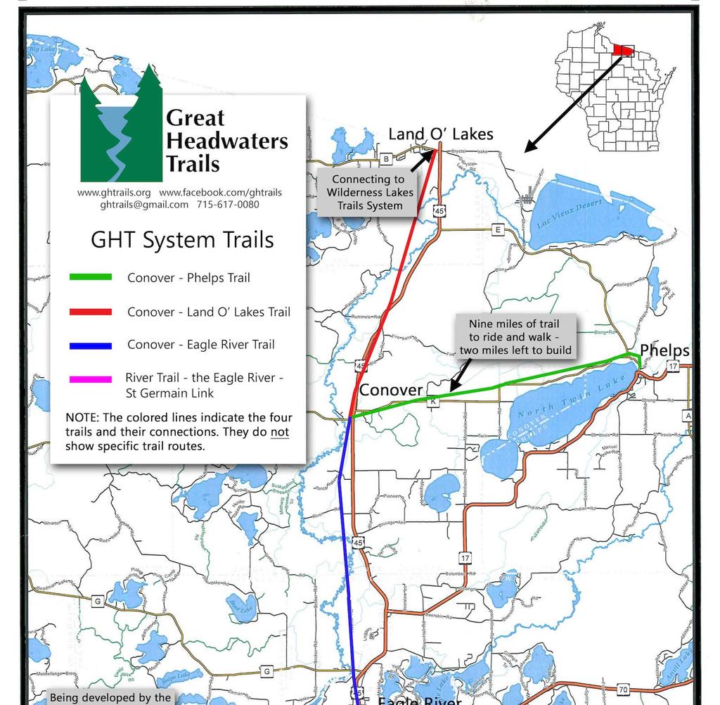

114
2018 Vilas County Comprehensive Outdoor Recreation Plan (CORP) Survey Results Summary
 Survey Results Summary") 2018 Vilas County Comprehensive Outdoor Recreation Plan (CORP) Survey Results Summary In the spring of 2018 NCWRPC mailed survey notices to each town, and emailed survey notices to a whole list of outdoor
2018 Vilas County Comprehensive Outdoor Recreation Plan (CORP) Survey Results Summary In the spring of 2018 NCWRPC mailed survey notices to each town, and emailed survey notices to a whole list of outdoor
2018 Oneida County Outdoor Recreation Plan (ORP) Survey Results Summary
 Survey Results Summary") 2018 Oneida County Outdoor Recreation Plan (ORP) Survey Results Summary In the spring of 2018 NCWRPC mailed survey notices to each town, and either emailed or mailed survey notices to a whole list of outdoor
2018 Oneida County Outdoor Recreation Plan (ORP) Survey Results Summary In the spring of 2018 NCWRPC mailed survey notices to each town, and either emailed or mailed survey notices to a whole list of outdoor
Oneida County Outdoor Recreation Plan
 Oneida County Outdoor Recreation Plan Effective January 1, 2019 to December 31, 2023 Primarily Responsible for Oneida County Forestry, Land, and Recreation Department Managed Facilities. Projects are also
2018 Adams County Outdoor Recreation Plan (ORP) Survey Results Summary
 Survey Results Summary") 2018 Adams County Outdoor Recreation Plan (ORP) Survey Results Summary NCWRPC mailed survey posters to each town, and either emailed or mailed survey notices to a whole list of outdoor recreation groups
2018 Adams County Outdoor Recreation Plan (ORP) Survey Results Summary NCWRPC mailed survey posters to each town, and either emailed or mailed survey notices to a whole list of outdoor recreation groups
2. Goals and Policies. The following are the adopted Parks and Trails Goals for Stillwater Township:
 D. PARKS AND TRAILS 1. Introduction Stillwater Township s population is relatively low, with most residents living on rural residences on large lots. The need for active park space has been minimal in
Preferred Recreation Recommendations Stemilt-Squilchuck Recreation Plan March 2018
 Preferred Recreation Recommendations Stemilt-Squilchuck Recreation Plan March 2018 Below are the recommended recreation ideas and strategies that package together the various recreation concepts compiled
Blueways: Rivers, lakes, or streams with public access for recreation that includes fishing, nature observation, and opportunities for boating.
 Parks, Open Space and Trails PRINCE WILLIAM COUNTY 2008 COMPREHENSIVE PLAN TRAILS PLAN CONTENTS The components of the trails plan are: Intent Definitions Goals, Policies, and Action Strategies Trails Map
Oneida County Outdoor Recreation Plan
 Oneida County Outdoor Recreation Plan Effective January 1, 2014 to December 31, 2018 Primarily Responsible for Oneida County Forestry, Land, and Recreation Department Managed Facilities. Projects also
Schoolcraft Township is located in northeast Houghton County. A portion of the township borders Keweenaw County and Lake Superior.
 COMMUNITY DESCRIPTION Schoolcraft Township is located in northeast Houghton County. A portion of the township borders Keweenaw County and Lake Superior. The township is largely rural but has one main population
10/25/2013. What is the SCORP?! 2013 Local Government Survey 2013 Statewide Public Survey Advisory Group Priority Areas Your Suggestions!
 COLORADO OUTDOOR RECREATION TRENDS RESULTS FROM THE SCORP AND STATEWIDE Colorado Outdoor Recreation Resource Partnership September 2013 PRESENTATION What is the SCORP?! 2013 Local Government Survey 2013
Lincoln County ORP Survey Response Summary
 Lincoln County ORP Survey Response Summary North Central Wisconsin Regional Planning Commission Q1 Which recreational activities did you participate in during 2015? (Choose all that apply.) Answered: 125
Lincoln County Outdoor Recreation Plan
 Lincoln County Outdoor Recreation Plan Also covering the municipalities within Lincoln County Prepared by: North Central Wisconsin Regional Planning Commission Lincoln County Board of Supervisors Robert
This section of the Plan provides a general overview of the Smoky Mountain Region. It consists of the following four subsections:
 SECTION 3 COMMUNITY PROFILE This section of the Plan provides a general overview of the Smoky Mountain Region. It consists of the following four subsections: 3.1 Geography and the Environment 3.2 Population
Northeast Quadrant Distinctive Features
 NORTHEAST QUADRANT Northeast Quadrant Distinctive Features LAND USE The Northeast Quadrant includes all the area within the planning area that is east of Interstate 5 and to the north of State Route 44.
STOWER SEVEN LAKES STATE RECREATION TRAIL POLK COUNTY, WISCONSIN. MASTER PLAN June, 2018
 STOWER SEVEN LAKES STATE RECREATION TRAIL POLK COUNTY, WISCONSIN MASTER PLAN June, 2018 Polk County Environmental Services Committee Kim O Connell-Chairman Brad Olson -Vice Chairman Jim Edgell Doug Route
Airport Planning Area
 PLANNING AREA POLICIES l AIRPORT Airport Planning Area LOCATION AND CONTEXT The Airport Planning Area ( Airport area ) is a key part of Boise s economy and transportation network; it features a multi-purpose
Silver Lake Park An Environmental Jewel for the Citizens of Prince William County
 Silver Lake Park An Environmental Jewel for the Citizens of Prince William County The Prince William Park Authority Mission Statement states: The Prince William County Park Authority will create quality
Oneida County Outdoor Recreation Plan
 Oneida County 2009-2013 Effective January 1, 2009 to December 31, 2013 Oneida County Forestry, Land, and Outdoor Recreation Department Managed Facilities Also covering some local governments within Oneida
Chapter eight. Parks and Recreation. Introduction. Crystal Lake Park District
 Chapter eight Parks and Recreation Introduction One of the indicators of quality of life in a city is the parks and recreation system. The City of Crystal Lake is fortunate to have an excellent parks and
Procedure for the Use of Power-Driven Mobility Devices on Mass Audubon Sanctuaries 1 September 17, 2012
 Procedure for the Use of Power-Driven Mobility Devices on Mass Audubon Sanctuaries 1 September 17, 2012 Background As part of Mass Audubon s mission to preserve the nature of Massachusetts for people and
Parks & Recreation Areas Program
 PARKS & RECREATION Parks & Recreation Areas Program As part of its mission to conserve and protect natural resources, the Upper Big Blue Natural Resources District (NRD) has been involved in several large-scale
O REGON TRAILS SUMMIT. Oregon Trails Summit. Rogue River National Forest
 O REGON TRAILS SUMMIT Oregon Trails Summit 2014 Rogue River National Forest OREGON TRAILS 2015: A VISION FOR THE FUTURE The 2015-2024 Oregon Statewide Trails Plan Why do a trails plan? 2005-2014 Oregon
(N W ) sized to accommodate equestrian trailers. Tamarack Creek 9. Along the Wisconsin River. 1 $5/night
 sized to accommodate equestrian trailers. Tamarack Creek 9. Along the Wisconsin River. 1 $5/night") 06 Vilas County Public Campground Directory (Prices and facilities are subject to change without notice. GPS coordinates are provided for general information and may be for parking area or boat landing
06 Vilas County Public Campground Directory (Prices and facilities are subject to change without notice. GPS coordinates are provided for general information and may be for parking area or boat landing
SUMMER VILLAGE OF SILVER SANDS. Municipal Development Plan
 SUMMER VILLAGE OF SILVER SANDS Municipal Development Plan Bylaw 253-2014 Adopted August 22, 2014 Summer Village of Silver Sands Municipal Development Plan Bylaw No. 253-2014 Page 2 1 INTRODUCTION 1.1 SETTING
Stambaugh Township 5-Year Recreation Plan - DRAFT
 Stambaugh Township 5-Year Recreation Plan - DRAFT Stambaugh Township GEI Project No. 1702677 January 5, 2018 Table of Contents 1. Community Description 1 2. Administrative Structure 2 3. Recreation Inventory
Chapter 6. Action Program. Heart of the Lakes Area Recreation Plan
 Heart of the Lakes Area Recreation Plan 1. Design and construct the following trails (please see the following map): a. the Speedway Trail 1) primary pathway the main trail 2) secondary pathway the proposed
Park Design and Location Criteria
 Park Design and Location Criteria This section is presented in the interest of assisting park and recreation agencies in the development of a system of parks and recreation areas. A recreation system is
City of Durango 5.8 FUNDING TRAILS DEVELOPMENT
 5.8 FUNDING TRAILS DEVELOPMENT The City has been successful in establishing dedicated local funding sources as well as applying for grants to develop the City s trail system, having received nearly $2.4
MASTER PLAN EXECUTIVE SUMMARY
 Biscuit Run State Park Scottsville Road (State Route 20) Charlottesville, VA 22902 Biscuit Run State Park MASTER PLAN EXECUTIVE SUMMARY Department of Conservation and Recreation Division of Planning and
F. Forest Recreation Management
 F. Forest Recreation Management F.1) Park and Recreation Management F.1.A. Program Overview. The park and recreation program has been in existence since 1980. With ever increasing outdoor recreation demands
13.1 REGIONAL TOURISM ISSUES AND SUMMARY OF FINDINGS
 13 REGIONAL TOURISM T he County of Mariposa s recreation needs and facilities fall within two categories: regional tourism and local recreation. This Element focuses on regional tourism issues related
Susitna-Watana Hydroelectric Project (FERC No ) Recreation Resources Study Study Plan Section Study Implementation Report
 Recreation Resources Study Study Plan Section Study Implementation Report") (FERC No. 14241) Recreation Resources Study Study Plan Section 12.5 2014 Study Implementation Report Prepared for Prepared by AECOM November 2015 TABLE OF CONTENTS 1. Introduction... 4 2. Study Objectives...
(FERC No. 14241) Recreation Resources Study Study Plan Section 12.5 2014 Study Implementation Report Prepared for Prepared by AECOM November 2015 TABLE OF CONTENTS 1. Introduction... 4 2. Study Objectives...
Introduction. Implementation of the Village of Capac Master Plan
 Implementation of the Village of Capac Master Plan Introduction The key to a well-planned community is the actual day-to-day use of planning documents, like this Master Plan. Because this plan is to be
Tracy Ridge Shared Use Trails and Plan Amendment Project
 Tracy Ridge Shared Use Trails and Plan Amendment Project Scoping Document Forest Service Allegheny National Forest Bradford Ranger District McKean, County, Pennsylvania In accordance with Federal civil
ROAD AND TRAIL PROJECT APPROVAL
 ROAD AND TRAIL PROJECT APPROVAL www.marincountyparks.org Marin County Parks, 3501 Civic Center Dr, Suite 260, San Rafael, CA 94903 DATE: July 12, 2017 PRESERVE: Gary Giacomini Open Space Preserve PROJECT:
CHAPTER FOUR: TRANSPORTATION
 CHAPTER FOUR: TRANSPORTATION Barron County Comprehensive Plan: Transportation Page 61 Background Transportation facilities have a significant influence on land use, development and quality of life for
Department of Agricultural and Resource Economics, Fort Collins, CO
 June 2007 EDR 07-15 Department of Agricultural and Resource Economics, Fort Collins, CO 80523-1172 http://dare.colostate.edu/pubs OF WINE AND WILDLIFE: ASSESSING MARKET POTENTIAL FOR COLORADO AGRITOURISM
National Recreation Trail Application for Designation
 National Recreation Trail Application for Designation Introduction Thank you for your interest in the National Recreation Trail (NRT) program. Completed NRT application packages must be submitted by December
2014 STATEWIDE COMPREHENSIVE OUTDOOR RECREATION PLAN
 2014 STATEWIDE COMPREHENSIVE OUTDOOR RECREATION PLAN SUSTAINING COLORADO S OUTDOOR RECREATION FUTURE SECTION 1: INTRODUCTORY INFORMATION WHAT IS THE SCORP? The SCORP update is required every five years
Georgetown-Lewes Rail/Trail Study. Rail/Trail Study: Cool Spring to Cape Henlopen State Park New Road Extension (House Resolution No.
 Georgetown-Lewes Rail/Trail Study Rail/Trail Study: Cool Spring to Cape Henlopen State Park New Road Extension (House Resolution No. 47) August 22, 2011 Presentation Outline Background Benefits Statewide
4.0 OUTDOOR RECREATION 4.1 PUBLIC LANDS
 4.0 OUTDOOR RECREATION 4.1 PUBLIC LANDS Public lands provide a wide range of recreational opportunities and are considered a valuable community asset. There may be seasonal and/or other use restrictions
JOSLIN FIELD, MAGIC VALLEY REGIONAL AIRPORT DECEMBER 2012
 1. Introduction The Federal Aviation Administration (FAA) recommends that airport master plans be updated every 5 years or as necessary to keep them current. The Master Plan for Joslin Field, Magic Valley
SAXON HARBOR REDEVELOPMENT SURVEY
 SAXON HARBOR REDEVELOPMENT SURVEY SEPTEMBER, 2016 1,173 RESPONSES 1 BACKGROUND 1. WHAT TYPES OF ACTIVITIES DO YOU ENGAGE IN AT SAXON HARBOR Sightseeing Swimming Picnicing Fishing Camping Photography Motorized
Section II. Planning & Public Process Planning for the Baker/Carver Regional Trail began in 2010 as a City of Minnetrista initiative.
 Section II Planning & Public Process Planning for the began in 2010 as a City of initiative. city staff began discussions with the Park District on the possibility of a north/south regional trail connection
FINAL TESTIMONY 1 COMMITTEE ON RESOURCES UNITED STATES HOUSE OF REPRESENTATIVES. July 13, 2005 CONCERNING. Motorized Recreational Use of Federal Lands
 FINAL TESTIMONY 1 STATEMENT OF DALE BOSWORTH CHIEF Of the FOREST SERVICE UNITED STATES DEPARTMENT OF AGRICULTURE Before the SUBCOMMITTEE ON FORESTS AND FOREST HEALTH And the SUBCOMMITTEE ON NATIONAL PARKS,
Town of Cable Recreation Plan
 Town of Cable Recreation Plan April, 2018 \ 2018-2023 Prepared by 2018 Town Board and Plan Commissioners Information also prepared with input from the Bayfield County Outdoor Recreation Plan of 2015-2019,
EXECUTIVE SUMMARY PROGRAM DEVELOPMENT REPORT PURPOSE EXISTING SETTING EXPANDING PARKLAND
 EXECUTIVE SUMMARY PROGRAM DEVELOPMENT REPORT PURPOSE As the culmination of the first phase of the master planning process, this Program Development Report creates the framework to develop the Calero County
3.0 LEARNING FROM CHATHAM-KENT S CITIZENS
 3.0 LEARNING FROM CHATHAM-KENT S CITIZENS An important aspect in developing the Chatham-Kent Trails Master Plan was to obtain input from stakeholders and the general public. Throughout the course of the
CHAPTER 5. Chapter 5 Recreation Element
 CHAPTER 5 Recreation Element Chapter 5 Recreation Element The Recreation Element of the Meyers Area Plan is a supplement to the Recreation Element of the TRPA Regional Plan and the El Dorado County General
Village of Stockholm
 Village of Stockholm 2016 Plan for the Community Park Park Committee: Harley Cochran Mark Coronna Steve Grams Jerry Larson Hap Palmberg FINAL: FOR VILLAGE BOARD APPROVAL March 8, 2016 1 Table of Contents
Chapter 9 Recreation
 Chapter 9 Chapter 9 1.0 INTRODUCTION The Town of Littleton is within one of New England s most important recreation areas. More than three million people live within 100 miles of the area. Local residents
Lincoln County Outdoor Recreation Plan
 Lincoln County Outdoor Recreation Plan Also covering the municipalities within Lincoln County Prepared by: North Central Wisconsin Regional Planning Commission Lincoln County Board of Supervisors Robert
Crystal Lake Area Trails
 Lake Area Trails Welcome to the Lake area of the Big Snowy Mountains! This island mountain range in central Montana features peaks reaching to 8,600 feet and long, high ridges from which vistas of the
METROPOLITAN COUNCIL 390 North Robert Street, St. Paul, MN Phone (651) TDD (651)
 TDD (651)") DATE: March 27, 2012 METROPOLITAN COUNCIL 390 North Robert Street, St. Paul, MN 55101 Phone (651) 602-1000 TDD (651) 291-0904 TO: Metropolitan Parks and Open Space Commission FROM: Arne Stefferud, Planning
DATE: March 27, 2012 METROPOLITAN COUNCIL 390 North Robert Street, St. Paul, MN 55101 Phone (651) 602-1000 TDD (651) 291-0904 TO: Metropolitan Parks and Open Space Commission FROM: Arne Stefferud, Planning
Figure 1.1 St. John s Location. 2.0 Overview/Structure
 St. John s Region 1.0 Introduction Newfoundland and Labrador s most dominant service centre, St. John s (population = 100,645) is also the province s capital and largest community (Government of Newfoundland
Continental Divide National Scenic Trail Legislative History and Planning Guidance
 Continental Divide National Scenic Trail Legislative History and Planning Guidance Legislation, Policy, and Direction Regarding National Scenic Trails The National Trails System Act, P.L. 90-543, was passed
National Recreation Trail Update Form
 National Recreation Trail Update Form Introduction Thank you for taking the time to complete this form. Your assistance will help ensure that the National Recreation Trail (NRT) database is complete and
Map 1.1 Wenatchee Watershed Land Ownership
 Map 1.1 Wenatchee Watershed Land Ownership Map 1.1 Wenatchee Watershed Land Ownership The Wenatchee watershed lies in the heart of Washington state in Chelan County. Just larger than the state of Rhode
Saginaw Charter Township Master Plan
 Saginaw Charter Township Master Plan Overview of Draft & Public Hearing August 20, 2014 230 South Washington Avenue Saginaw Michigan 48607 (989) 754-4717 www.spicergroup.com Saginaw Charter Township Master
(/ 12 (/ 18 (/ 18 (/ 12 (/ 51 (/ 14 Æ%106 Æ% 106 Æ% 213 Æ% 104 Æ% 89 Æ% 26 Æ% 73 Æ% 59 Æ% 138 Æ% 92 Æ% 26 Æ% 67 Æ% 11 Æ% 11 Æ% 11. Æÿ H Æÿ Z.
 WAUKESHA Existing Ice Age Trail, subject to change as it evolves toward completion Glacial Drumlin Rail-Trail 94 Ice Age Trail Rock, Walworth and Jefferson Counties Other Trail Unofficial Connecting Route
Flow Stand Up Paddle Board Parkway Plan Analysis
 Regional Parks Department Jeffrey R. Leatherman, Director County of Sacramento Divisions Administration Golf Leisure Services Maintenance Rangers Therapeutic Recreation Services Flow Stand Up Paddle Board
TRAIL DATABASE SCHEMA (8/26/2014)
") Trail Data Model for LINES Source Data Source Agency dataagency Agency or entity that created the dataset where the original line was sourced from. Source Date of Last Data Used to Update sourcedate Publication
Trail Data Model for LINES Source Data Source Agency dataagency Agency or entity that created the dataset where the original line was sourced from. Source Date of Last Data Used to Update sourcedate Publication
4.0 Context for the Crossing Project
 4.0 Context for the Crossing Project This section provides background information about key features of the North Douglas Crossing project area, and opportunities and constraints. This information is important
COASTAL CONSERVANCY. Staff Recommendation December 2, 2004 COYOTE HELLYER COUNTY PARK BAY AREA RIDGE TRAIL
 COASTAL CONSERVANCY Staff Recommendation December 2, 2004 COYOTE HELLYER COUNTY PARK BAY AREA RIDGE TRAIL File No. 04-057 Project Manager: Amy Hutzel RECOMMENDED ACTION: Authorization to disburse up to
Recreationists on the Gifford Pinchot National Forest: A Survey of User Characteristics, Behaviors, and Attitudes
 Recreationists on the Gifford Pinchot National Forest: A Survey of User Characteristics, Behaviors, and Attitudes by Alan R. Graefe The Pennsylvania State University Robert C. Burns University of Florida
Chambers of Commerce and Lake Groups advertised this NCWRPC created online survey that was : Opened: August 22, 2012; and Closed: October 4, 2012.
 Vilas County Outdoor Recreation Survey Chambers of Commerce and Lake Groups advertised this NCWRPC created online survey that was : Opened: August 22, 202; and Closed: October 4, 202. Q What Vilas County
DRAFT GENERAL IMPLEMENTATION PLAN AND SPECIFIC IMPLEMENTATION PLAN MIDDLETON MUNICIPAL AIRPORT MOREY FIELD. Revised 12/12/03
 DRAFT GENERAL IMPLEMENTATION PLAN AND SPECIFIC IMPLEMENTATION PLAN MIDDLETON MUNICIPAL AIRPORT MOREY FIELD Revised 12/12/03 As recommended for approval by the Plan Commission General Project Description
Rule Governing the Designation and Establishment of All-Terrain Vehicle Use Trails on State Land
 Rule Governing the Designation and Establishment of All-Terrain Vehicle Use Trails on State Land 1.0 Authority 1.1 This rule is promulgated pursuant to 23 V.S.A. 3506. Section 3506 (b)(4) states that an
Lake Myra County Park. Wake County, North Carolina Community Forum #2 June 12, 2008
 Lake Myra County Park Wake County, North Carolina Community Forum #2 June 12, 2008 Welcome and Introduction Meeting Agenda Welcome Introductions of Project Team Master Plan Process Community Forum #1 Updates
Hazlet. 1. Overview of Hazlet and Its Waterfront. Hazlet Township. 1.1 Geographic Overview
 Hazlet 1. Overview of Hazlet and Its Waterfront 1.1 Geographic Overview Hazlet Township is located in Monmouth County. The Township has a land area of 5.6 square miles. Situated in the Bayshore region
CHAPTER FIVE PROSPECTS FOR FUTURE ECONOMIC DEVELOPMENT
 CHAPTER FIVE PROSPECTS FOR FUTURE ECONOMIC DEVELOPMENT 5.1 GENERAL The recommended type and location of future land uses in Alpine should, in part, consider potential opportunities for future economic
WASHINGTON STATE PARKS LAND CLASSIFICATION SYSTEM
 WASHINGTON STATE PARKS LAND CLASSIFICATION SYSTEM Administrative Code Establishing Land Classification System WAC 352-16-020 Land classification system. State park areas are of statewide natural, cultural,
Camping (Primitive) Camping (RV) Electrical Potable Water Grill Established Fire Pit Picnic Table
 Camping (RV) Electrical Potable Water Grill Established Fire Pit Picnic Table") Alden - 9th Road River Mile 777 Map: 38.20833, -98.32031 Managing Agency: Kansas Department of Wildlife, Parks & Tourism Nearest Community: Alden, Rice County Kansas Developed Amenities Provided Parking
Alden - 9th Road River Mile 777 Map: 38.20833, -98.32031 Managing Agency: Kansas Department of Wildlife, Parks & Tourism Nearest Community: Alden, Rice County Kansas Developed Amenities Provided Parking
Business Item No XXX. Proposed Action That the Metropolitan Council approve the Coon Creek Regional Trail Master Plan.
 Business Item No. 2015-XXX Metropolitan Parks and Open Space Commission Meeting date: July 7, 2015 For the Community Development Committee meeting of July 20, 2015 For the Metropolitan Council meeting
CHAPTER III: TRAIL DESIGN STANDARDS, SPECIFICATIONS & PERMITS
 CHAPTER III Trail Design Standards, Specifications & Permits This chapter discusses trail standards, preferred surface types for different activities, permits, and other requirements one must consider
Parkland County Municipal Development Plan Amendment Acheson Industrial Area Structure Plan
 Parkland County Municipal Development Plan Amendment Acheson Industrial Area Structure Plan New Plan Acheson Industrial Area Structure Plan Amendment Parkland County Municipal Development Plan Board Reference
Wallowa Falls Hydroelectric Project FERC Project No. P-308 Proposed Study Plans - Recreation August 2011
 Wallowa Falls Hydroelectric Project FERC Project No. P-308 August 2011 Prepared by: PacifiCorp Energy Hydro Resources 825 NE Multnomah, Suite 1500 Portland, OR 97232 For Public Review Wallowa Falls Hydroelectric
Town of Oakfield Agricultural and Farmland Protection Plan
 SECTION III COMMUNITY OVERVIEW A. Regional Setting / Location The Town of Oakfield is located in the northwestern portion of Genesee County. Located west of New York's Finger Lakes, the Town is uniquely
Rating: 5.0 (scale of 1-10)
") 95 Community Trail System Groundcover: 2-metre paved path, 1- metre grass buffer on either side. Location: Fort St. John Ownership: City of Fort St. John Rating: 5.0 (scale of 1-10) Strategic value: Linear
95 Community Trail System Groundcover: 2-metre paved path, 1- metre grass buffer on either side. Location: Fort St. John Ownership: City of Fort St. John Rating: 5.0 (scale of 1-10) Strategic value: Linear
NEW MEADOWS PARK PROPOSED MASTER PLAN
 NEW MEADOWS PARK PROPOSED MASTER PLAN A vision for your neighborhood park, the draft master plan is ready for your review. Tuesday September 12 th, 2017 5:30-7:00 PM Hellgate School District #4 middle
BAYFIELD COUNTY FOREST COMPREHENSIVE LAND USE PLAN TABLE OF CONTENTS CHAPTER 700 ACCESS MANAGEMENT ROADS AND TRAILS
 BAYFIELD COUNTY FOREST COMPREHENSIVE LAND USE PLAN TABLE OF CONTENTS CHAPTER 700 ACCESS MANAGEMENT ROADS AND TRAILS 700 Access Management/Roads and Trails 3 700.1 History 3 700.2 Current Status 3 700.3
Understanding the caring capacity of the visitor experience Provide facilities to support a high level user experience Address visual quality through
 Understanding the caring capacity of the visitor experience Provide facilities to support a high level user experience Address visual quality through recreation ecological restoration opportunities Collaboration
Economic Development and Tourism
 SECTION 4 SECTION 4 Economic Development and Tourism 4. Economic Development and Tourism Tourism plays a very important role in Niagara s economy, providing employment and generating business for support
Decision Memo Ice Age Trail Improvement (CRAC 37)
") Decision Memo Ice Age Trail Improvement (CRAC 37) U.S. Forest Service Chequamegon-Nicolet National Forest, Medford-Park Falls Ranger District Taylor County, Wisconsin T32N, R2W, Town of Grover, Section
Decision Memo Ice Age Trail Improvement (CRAC 37) U.S. Forest Service Chequamegon-Nicolet National Forest, Medford-Park Falls Ranger District Taylor County, Wisconsin T32N, R2W, Town of Grover, Section
State Park Visitor Survey
 State Park Visitor Survey Methods, Findings and Conclusions State s Department of Recreation, Park and Tourism Management surveyed state park visitor and trip characteristics, and collected evaluations
Understanding user expectations And planning for long term sustainability 1
 Understanding user expectations And planning for long term sustainability 1 What is a natural surface trail? It can be as simple has a mineral soil, mulched or graveled pathway, or as developed as elevated
FEASIBILITY CRITERIA
 This chapter describes the methodology and criteria used to evaluate the feasibility of developing trails throughout the study areas. Land availability, habitat sensitivity, roadway crossings and on-street
A CASE FOR COMPLETING THE JORDAN RIVER PARKWAY: A
 A CASE FOR COMPLETING THE JORDAN RIVER PARKWAY: A safe crossing at 9000 South and 850 West Proposed 9000 South Underpass Parkway Timeline Parkway, Trail, and Tourism Facts Blueprint Jordan River 1971 1973
CHAPTER 9. PARKS, RECREATION, TRAILS AND NATURAL AREA RESOURCES
 CHAPTER 9. PARKS, RECREATION, TRAILS AND NATURAL AREA RESOURCES The forms of recreation chosen by residents and visitors in the CBJ are as diverse as the population. Many people choose to recreate in developed
Segment 2: La Crescent to Miller s Corner
 goal of the USFWS refuges is to conserve, protect and enhance fish, wildlife and plants and their habitats for the continuing benefit of the American people. Refuge lands are used largely for fishing,
BACKCOUNTRY TRAIL FLOOD REHABILITATION PROGRAM
 BACKCOUNTRY TRAIL FLOOD REHABILITATION PROGRAM Backcountry Trail Flood Rehabilitation A June 2013 Flood Recovery Program Summary In June 2013, parts of Southern Alberta were devastated from significant
DRAFT - APRIL 13, 2007 ROUTING STUDY FOR TRAIL CONNECTIONS BETWEEN CALAIS AND AYERS JUNCTION
 DRAFT - APRIL 13, 2007 ROUTING STUDY FOR TRAIL CONNECTIONS BETWEEN CALAIS AND AYERS JUNCTION Abstract The vision for the East Coast Greenway is an off-road urban trail system running from Calais, Maine
Cascade River State Park Management Plan Amendment
 This document is made available electronically by the Minnesota Legislative Reference Library as part of an ongoing digital archiving project. http://www.leg.state.mn.us/lrl/lrl.asp Cascade River State
Greater Minnesota Regional Parks and Trails Commission Designation Application
 Greater Minnesota Regional Parks and Trails Commission Designation Application General Section Designation Application #: 16-043D Date Submitted: 04/28/2016 Park or Trail Name: Tioga Recreation Area District
Santa Clara South Hills Recreation Park Project Development and Management Plan
 Santa Clara South Hills Recreation Park Project Application for Land for Recreation or Public Purposes, City of Santa Clara, Utah Prepared for: Bureau of Land Management, St. George Field Office 345 East
PURPOSE AND NEED. Introduction
 Public Scoping: Allocation of Recreation Capacity for Commercial Outfitter Guide Services on North Kruzof Island Trails (Kruzof Island Outfitter Guide) PURPOSE AND NEED Introduction The U.S. Department
LANGLADE COUNTY ICE AGE NATIONAL SCENIC TRAIL CONDITIONS
 LANGLADE COUNTY ICE AGE NATIONAL SCENIC TRAIL CONDITIONS (As of September 1, 2014) Due to situations beyond the control of the Langlade County Chapter of the Ice Age Trail Alliance, conditions are constantly
Restore and implement protected status that is equivalent, or better than what was lost during the mid-1990 s
 THE ROSSLAND RANGE, OLD GLORY AREA. Executive summary. The Friends of the Rossland Range Society, on behalf of the local outdoor community, seeks to accomplish the following with respect to the Old Glory
Establishes a fare structure for Tacoma Link light rail, to be implemented in September 2014.
 RESOLUTION NO. R2013-24 Establish a Fare Structure and Fare Level for Tacoma Link MEETING: DATE: TYPE OF ACTION: STAFF CONTACT: PHONE: Board 09/26/2013 Final Action Ric Ilgenfritz, Executive Director,
Acquisition in fee simple of approximately one-half acre of property on the shore of Spring Lake to expand the Lakeside Beach Park.
 Lakeside Beach TF00-136 $122,550.00 in fee simple of approximately one-half acre of property on the shore of Spring Lake to exp the Lakeside Beach. 2000 River Ravines TF00-150 $910,000.00 in fee simple