A Continent of Villages. North American Societies before 1500
|
|
|
- Shana Harvey
- 5 years ago
- Views:
Transcription
1 A Continent of Villages North American Societies before 1500
2 The Resisted Revolution Adoption of farming was a gradual process that took hundreds of years. Not all Indian groups adopted agriculture. In some regions, climate combined with abundant food sources and cultural values led to rejection of farming. Foraging provided more varied diet, less influenced by climate, and required less work. Favorable climate was pivotal to the adoption of farming.
3 Increasing Social Complexity Farming stimulated increasing social complexity. Families were grouped into clans that bound people together into a tribe. Tribes were led by clan leaders of chiefs and advised by councils of elders. Chiefs were responsible for collection, storage, and distribution of food. Gender strictly divided labor. Marriage ties were generally weak. Growing populations required larger food surpluses and led to war.
4 The Southwest Aridity a central fact of life in the Southwest, though a number of rivers flow out of mountain plateaus. Most peoples practiced dry farming or irrigated agriculture, living in villages. Region home to Yuman, Pimas, Pueblos, and most recent arrivals, Athapascans, who developed into Navajos and Apaches.
5 Desert Culture Desert Culture was way of life based on small game hunting and intensified foraging. Foraging followed seasonal routes. Skills included: producing fiber baskets for collecting; pitch-lined baskets for cooking; nets and traps; stone tools. Desert Culture spread to Great Plains and Southwest.
6 Farmers of the Southwest Farming began to emerge in the Southwest during the first millennium B.C.E. The Mogollon: were first to practice agriculture, growing maize, beans, and squash; lived in pit houses in permanent villages near streams from about 250 B.C.E. to C.E The Hohokam: grew maize, beans, squash, tobacco, and cotton; lived in villages in the floodplain of the Salt and Gila Rivers between C.E. 300 to 1500; developed the first irrigation system in North America north of Mexico; shared many traits with Mesoamerican civilization.
7 The Anasazis Anasazi farming culture arose on plateau of Colorado River around present-day Four Corners area where Arizona, Utah, Colorado, and New Mexico meet. The Anasazi: built densely populated, multistoried apartment complexes clustered around kivas; grew high-yield maize in terraced fields irrigated by canals; consisted of 25,000 communities that extended over area larger than California; declined because of extended drought and arrival of Athapascan migrants, leading to abandonment of Four Corners area.
8 The Northeast Colder part of Eastern Woodlands with varied geography of coastal plains, mountain highlands, rivers, lakes, and valleys. The Iroquois: lived in present-day Ontario and upstate New York; grew corn, beans, squash, and sunflowers; honored matrilineal family lineage centered around longhouses; formed confederacy to eliminate warfare. The Algonquians: comprised at least fifty distinct patrilineal cultures; were organized into bands with loose ethnic affiliation in the north; farmed and lived in villages in the south.
9 Forest Efficiency Eastern North America was a vast forest. Developed during Archaic period, "Forest Efficiency" included: small game hunting; gathering seeds, nuts, roots, and other plants; burning woodlands and prairies to stimulate growth of berries, fruits, and roots, creating meadows that provided food that attracted grazing animals for hunting; fishing.
10 Farmers of the Eastern Woodlands Farming led to development of Woodland culture in eastern North America about 3,000 years ago. Woodland culture: combined gathering and hunting with farming, eventually growing maize; developed a complex social structure. Adena culture occupied Ohio River basin from before 1000 B.C.E. to about C.E They lived in villages and built large burial mounds.
11 The South Mild climate with short winters and long summers proved ideal for farming. Large populations lived in villages and towns, often ruled by chiefs. Region home to Choctaw, Chickasaw, Creeks, and Cherokees.
12 Mississippian Society Introduction of bow and arrow, development of new maize variety, and switch from digging-sticks to hoes were basis of Mississippian culture. Mississippian culture: developed sophisticated maize farming; centered around permanent villages on Mississippi River floodplain, with Cahokia as urban center; built large effigy earthworks; had complex divisions of labor headed by elite class of rulers; had urban centers linked by river transportation system.
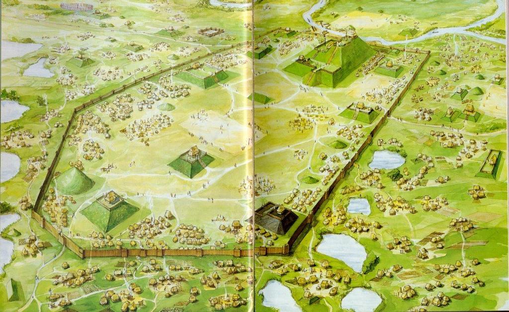
13 Cahokia
14 Cahokia In the mid-1200s, Cahokia was an urban center of about 30,000 people. They were sophisticated farmers and crafts workers who participated in long-distance trade. The Cahokia residents had a strong religious tradition and built a series of mounds.
15 Occupation This site was first inhabited by Indians of the Late Woodland culture about 700. The site grew during the following Mississippian period, after 900, and by , the Cahokia site was the regional center for the Mississippian culture with many satellite communities, villages and farmsteads around it. After 1200, the population began to decline and the site was abandoned by 1400.

16 Map of Cahokia

17 Mounds in America
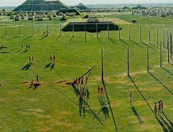
18 Cahokia Agriculture important to rise of Cahokia Many of the foodstuffs used came from Central America maize Does not mean there was direct trade though networks of trade
19 Maize Required a large amount of water Cahokia had extensive irrigation system to grow maize Irrigation projects means a centralized government and likely social hierarchy
20 Cahokia Reconstruction

21 Additional Reconstruction
22 City Center Site center is basically diamond shaped with an interior palisaded core 4.58 km east-west by 3.67 km north-south and 13.4 km2 120 mounds City center: Monk's Mound plus 16 other mounds Basically shaped like a squat boat heading south Surrounded by a palisade on three sides (Cahokia Creek defining the fourth side) Majority of mounds lie outside the palisaded inner core One small mound yielded the burial of a high-ranking individual buried with: Caches of arrow heads, Polished stone, Mica, Six sacrificed male retainers, A separate mass grave containing 53 women
23 Palisade Excavations begun in 1966 uncovered a two-milelong stockade surrounding the central portion of Cahokia. The wall was started around 1100 and then rebuilt three times over a period of 200 years. Each construction required 15,000-20,000 oak and hickory logs, one foot in diameter and twenty feet tall. The logs were sunk into a trench four to five feet deep and were supported with horizontal poles or interwoven with saplings.
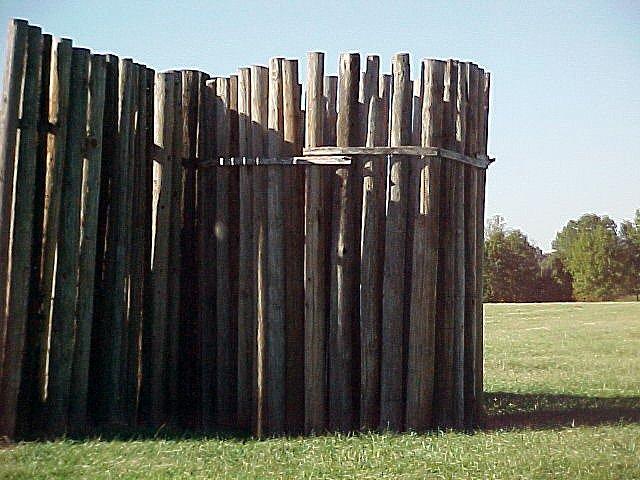
24 Reconstructed Palisade
25 Woodhenge Evidence that there were as many as five Woodhenges. These were built over a period of 200 years ( ). Fragments of wood were identified as red cedar and used for the posts.
26 "Woodhenge Functions Possible functions of "Woodhenge : Observatory (?): May have functioned like Stonehenge as a sort of "observatory" For astral and horizon alignment observations. three posts are crucial as seasonal markers -- those marking the first days of winter and summer (the solstices), and one halfway between marking the first days of spring and fall (the equinoxes). Sun Dance "Temple" (?)
27 Woodhenge Reconstruction

28 Burial & Status: Cahokia Mound 72 The wood dates to approximately burials were discovered in mound 72. Burials without litters


29 Mound 72 Burials with litters

30 Mound 72 Female Burial Pit (53 between 15 and 30)

31 Mound 72 Headless Burials

32 Reconstruction of Chief from Mound 72
33 Monk s Mound Largest monument at Cahokia is the famous Monk's Mound Monk's Mound: About 100 feet high Covers sixteen acres (3 acres more than the great pyramid at Giza!) (6.4 hectares) 316 by 241 meters (76156 square meters) rising over 30 meters high Contains over 600,000 cubic meters of earth Constructed in stages This constitutes one of the largest examples of prehistoric construction in the entire Western Hemisphere

34 Monk s Mound

35 Another View
36 Cahokia Population Between 1200 and 1300 was at its peak Between 25,000 and 40,000 people If 40,000, it would be the largest city in North America until surpassed by Philadelphia in 1800
37 Cahokia s Downfall Likely the result of ecological factors Depletion of lumber resources Ground became less fertile Diversion of a stream caused flooding By 1400 was abandoned
38 Mississippian Collapse Most Mississippian centers abandoned by 1500s, before contact with Europeans Reasons largely unknown. Natchez and Coosa still around until decimated by European disease.
AP US History: An Essential Coursebook (2nd Ed)
") Unit One: Early Native and Colonial Societies (1491-1754) Chapter One: Pre-Columbian Societies AP US History: An Essential Coursebook (2nd Ed) Environment and Geography How did physical features affect
Unit One: Early Native and Colonial Societies (1491-1754) Chapter One: Pre-Columbian Societies AP US History: An Essential Coursebook (2nd Ed) Environment and Geography How did physical features affect
Introduction to Indigenous America
 Introduction to Indigenous America Warm Up Draw in Indian, including his/her clothing and house. The Basics When I (Cash & Jolley, 30 years apart) went to School Indians Arrived 12,000 Years Ago Populations
The Mesoamerican Olmec, BCE
 Chapter 7: Peoples and Civilizations of the Americas, from 1200 BCE In a land with a shared culture, language, and religion, what remained a source of conflict for the Maya? What two specific regions compose
Mesoamerican Civilizations
 Mesoamerican Civilizations Human Migration Turn to page 237 and answer the two geography skillbuilder questions: What two continents does the Beringia land bridge connect? From where do scholars believe
The Mesoamerican cultures (1200BC- AD 1519)
") The Mesoamerican cultures (1200BC- AD 1519) Central America before the arrival of Europeans Click for Video There were many different cultures between 1200BC and AD 1519, but they share some important
The Mesoamerican cultures (1200BC- AD 1519) Central America before the arrival of Europeans Click for Video There were many different cultures between 1200BC and AD 1519, but they share some important
World History: Patterns of Interaction
 The Americans: A Separate World, 40,000 B.C. A.D. 700 Although early American civilizations remain mysterious, we know that the earliest Americans most likely migrated from Asia and that complex cultures
Ancient River Valley Civilizations Egypt
 Ancient River Valley Civilizations Egypt Geography of Egypt The first civilization in Africa developed along the Nile River, in a place called Egypt. These humans were at first nomadic, also known as hunter-gatherers.
Origins of Maya Culture. Preclassic Period. Cultural Roots. Keys to Maya Development. Middle Preclassic ( B.C.) Pacific coast region:
 Pacific coast region:") Origins of Maya Culture Preclassic Period Roots of Maya civilization begin in the Preclassic period, 2000 B.C A.D. 100. 2 regions active during this time: Southern highlands Central lowlands, or Peten
Origins of Maya Culture Preclassic Period Roots of Maya civilization begin in the Preclassic period, 2000 B.C A.D. 100. 2 regions active during this time: Southern highlands Central lowlands, or Peten
The Earliest Americans
 The Earliest Americans A Land Bridge Section The Earliest Americans The cultures of the first Americans, including social organization, develop in ways similar to other early cultures. The American Continents
Chapter 6. Early Societies in the Americas and Oceania. 2011, The McGraw-Hill Companies, Inc. All Rights Reserved.
 Chapter 6 Early Societies in the Americas and Oceania 1 Early Mesoamerican Societies, 1200 B.C.E.-1100 C.E. 2 Origins of Mesoamerican Societies Migration across Bering land bridge? Probably 13,000 B.C.E.,
Chapter 7 Geography and the Early Settlement of Egypt, Kush, and Canaan
 Chapter 7 Geography and the Early Settlement of Egypt, Kush, and Canaan How did geography affect early settlement in Egypt, Kush, and Canaan? Section 7.1 - Introduction RF/NASA//Corbis This satellite photograph
National Parks Called America s Best Idea
 National Parks Called America s Best Idea Welcome to This Is America in VOA Learning English. I'm Jim Tedder. And I'm Kelly Jean Kelly. This week on our program, we talk about national parks in the United
Geography: Unit 2. Map. Rivers. Major Physical Features. Slide 1. Slide 2. Slide 3. Slide 4. North America United States and Canada.
 Mississippi River Slide 1 Slide 2 Slide 3 Slide 4 Geography: Unit 2 North America United States Map Major Physical Features Mountain Ranges Brooks Range Mackenzie Mountains Coast Mountains Cascades Sierra
2017 Arizona Sinagua and Lots More
 2017 Arizona Sinagua and Lots More This time we stayed in a house that was owned and decorated by an artist who works with metal, particularly iron. His pieces were located within and without his house.
The cultures and civilizations of the Americas
 The cultures and civilizations of the Americas Where did the Native Americans come from? Who was in Meso-America? ( Middle America ) Olmec Teotihuacan Maya Toltec Aztec Teotihuacan Temples Quetzalcoatl
archeological site LOS MILLARES
 archeological site LOS MILLARES Aerial view of the plain of Los Millares between the Rambla de Huéchar and the River Andarax The archaeological site of Los Millares is located in the township of Santa
OKLAHOMA HISTORY OKLAHOMA S GEOGRAPHY
 OKLAHOMA HISTORY OKLAHOMA S GEOGRAPHY BOARD QUESTIONS 1) HOW BIG IS OKLAHOMA? 2) HOW MANY COUNTIES ARE IN OKLAHOMA? 3) HOW FAR IS IT FROM OKC TO LAS ANGLES, CALIFORNIA? 4) HOW MANY STATE BORDER OKLAHOMA?
Ancient Egypt and the Near East
 *O*»f ' i ft Ancient Egypt and the Near East Chapter 7 Chapter 8 Chapter 9 Geography and the Early Settlement of Egypt, Kush, and Canaan The Ancient Egyptian P h a r a o h s Daily Life in Ancient Egypt
Central American Societies
 Central American Societies EARLY MESOAMERICANS Area of central Mexico, Yucatan Peninsula, and northern Honduras Mesoamerica The Olmec First known civilization in Mesoamerica Emerge 1200 BCE Collapse in
ARCHAEOLOGY IN TUCSON
 ARCHAEOLOGY IN TUCSON Vol.1, No.4 Newsletter of the Institute for American Research Summer 1987 TRULY THE ORIGINAL TUCSON! In our last AIT newsletter, we presented some of the background about the San
Lesson 1: Land and Climate of the West Land and Water of the West 1. There are 13 states in the West, divided into 3 regions a. Southwest: Nevada,
 Lesson 1: Land and Climate of the West Land and Water of the West 1. There are 13 states in the West, divided into 3 regions a. Southwest: Nevada, Utah, Arizona, New Mexico b. Mountain States: Wyoming,
Archaeologists for Hire: An In-Class Activity
 Archaeologists for Hire: An In-Class Activity Beyond Grades: Capturing Authentic Learning Conference Welcome to the Marveloso Valley, a fictional valley on the central coast of Peru. Over the decades,
Reading Essentials and Study Guide
 Lesson 2 Early South American Civilizations ESSENTIAL QUESTIONS In what ways were civilizations in early Mesoamerica and South America complex? How were civilizations in early Mesoamerica and South America
Chapter 7. Geography and the Early Settlement of Egypt, Kush, and Canaan
 Chapter 7 Geography and the Early Settlement of Egypt, Kush, and Canaan Chapter 7 Geography and the Early Settlement of Egypt, Kush, and Canaan How did geography affect early in Egypt Kush, and Canaan?
How the Nile River Led to Civilization in Ancient Egypt
 How the Nile River Led to Civilization in Ancient Egypt By USHistory.org, adapted by Newsela staff on 03.07.17 Word Count 786 Level 950L TOP: This photo, taken around 1915, shows the flooding of the Nile
Economy 3. This region s economy was based on agriculture. 4. This region produced items such as textiles, iron, and ships in great quantities. For th
 Geography 1. This region has a climate of warm summers and snowy cold winters. 2. This region has a climate that is generally warm and sunny, with long, hot, humid summers, and mild winters, and heavy
Ancient Civilizations of the Western Hemisphere. Maya, Aztec, & Inca
 Ancient Civilizations of the Western Hemisphere Maya, Aztec, & Inca THE MAYA The maximum extent of the Maya Maya - Location southern Mexico into northern Central America called the Yucatan Peninsula Maya
Chapter 7: The Geography and Settlement of Egypt, Kush, and Canaan
 Chapter 7: The Geography and Settlement of Egypt, Kush, and Canaan Learning Target: I can explain how geography affected early settlement in Egypt, Kush, and Canaan. Ancient Egypt and the Middle East Can
The Nile Valley For use with pages 38 46
 READING ESSENTIALS AND STUDY GUIDE 2-1 The Nile Valley For use with pages 38 46 Key Terms cataract: spot of rapid waters in a river (page 39) delta: area of fertile soil at a river s end (page 39) papyrus:
Geography (cont) Sorghum, rice, millet, rice, wheat and corn grown on savannahs. Not just one big plain though mountainous and swampy areas too
 Sorghum, rice, millet, rice, wheat and corn grown on savannahs. Not just one big plain though mountainous and swampy areas too") Geography & Society in Africa: 500 BCE-900 CE Geography Around 5000 miles wide and long Various climates, jungles, snow-capped mountains, deserts and rain-soaked areas. 40% desert - largely uninhabitable
Geography & Society in Africa: 500 BCE-900 CE Geography Around 5000 miles wide and long Various climates, jungles, snow-capped mountains, deserts and rain-soaked areas. 40% desert - largely uninhabitable
World of the Incas and the North American Indians. Willow LeTard and Kevin Nguyen
 World of the Incas and the North American Indians Willow LeTard and Kevin Nguyen World of the Twantinsuyu 1300 c.e. in the Andean highlands Notable advances in metallurgy and architecture The Incas had
Early Andean Civilizations. Origins and Foundations
 Early Andean Civilizations Origins and Foundations Environmental Context Basic divisions: east/west, north/south Mountains, deserts, and rivers Vertical archipelago : adapting to climate diversity based
Classical Era Variations: The Americas 500 BCE to 1200 CE. AP World History Notes Chapter 7
 Classical Era Variations: The Americas 500 BCE to 1200 CE AP World History Notes Chapter 7 Mesoamerica Meso = means middle Mesoamerica = stretches from central Mexico to northern Central America The Maya
Geography: Unit 2. Map. Major Physical Features. Rivers. Mississippi River Missouri River Ohio River Rio Grande. Mackenzie. Colorado River Green River
 1 2 3 4 Geography: Unit 2 North America United States and Canada Map Major Physical Features Mountain Ranges Brooks Range Mackenzie Mountains Coast Mountains Cascades Sierra Nevada Rocky Mountains Appalachian
Native American Heritage in GRAND CENTRAL USA!
 Native American Heritage in GRAND CENTRAL USA! Day 1 Lawton OK Sulphur OK - Oklahoma City OK We begin our day with a tour of Fort Sill National Historic Landmark & Museum, a 19 th century frontier army
GEOGRAPHY AND HISTORY
 GEOGRAPHY AND HISTORY YEAR 1, PART 1 www.vicensvives.es Contents 01 Our planet Earth 02 The representation of the Earth: maps 03 The Earth s relief 04 Rivers and seas 05 Weather and climate 06 Climates
North Africa. Chapter 25. Chapter 25, Section
 Chapter 25, Section World Geography Chapter 25 North Africa Copyright 2003 by Pearson Education, Inc., publishing as Prentice Hall, Upper Saddle River, NJ. All rights reserved. Chapter 25, Section World
How the Nile River Led to Civilization in Ancient Egypt
 How the Nile River Led to Civilization in Ancient Egypt By USHistory.org on 03.07.17 Word Count 1,108 Level MAX TOP: This photo, taken around 1915, shows the flooding of the Nile River, which happens each
Hieroglyphics - A form of writing in which pictures are used to represent words and phrases
 Inca Civilization: 1200 AD 1535 AD -South America along Pacific Ocean. -Built vast network of roads and bridges. -Government run by emperor. -Built terraces on hills for farming. Macchu Picchu: Inca Palace.
Ak-Chin Indian Community. Est. 1912
 Ak-Chin Indian Community Population: 575 (related to Tohono O odham and Akimel O'odham people) Size: 22,000 acres (34 sq miles) Industry: Agriculture, industrial park, ranching Attractions: Harrah s Ak-Chin
Curriculum Pacing Guide Grade/Course 5 Th Grade Geography Grading Period 1 st Nine Weeks
 2013-2014 Curriculum Pacing Guide Grade/Course 5 Th Grade Grading Period 1 st Nine Weeks Time Frame Unit/ photographs, pictures, and tables to Locate and identify: Continents and Oceans -North America
A History of West Chicago
 A History of West Chicago The Prairie Prairie Inhabitants Winfield Mounds Dickson Mounds, near Lewistown, in southern Illinois. An example of what Native burial mounds look like. First Permanent Settlers
The Geological Pacific Northwest. Wednesday February 6, 2012 Pacific Northwest History Mr. Rice
 The Geological Pacific Northwest Wednesday February 6, 2012 Pacific Northwest History Mr. Rice 1 Free Response #2 Please do not simply list the items for this response. Full sentences!!! Minimum of 3-5
Downtown Phoenix yields a rare archaeological find
 Email this article Print this article Most popular pages Click to send Choose File Print or Ctrl P or Apple P Today This Week Downtown Phoenix yields a rare archaeological find As convention center rises,
Student Handout 1 Overview of the Mayans
 Source 1: FAST FACTS Student Handout 1 Overview of the Mayans 1. The Ancient Mayan lived in the Yucatán around 2600 B.C. Today, this area is southern Mexico, Guatemala, northern Belize and western Honduras.
Climate. The Grand Canyon State. Established th State
 The Grand Canyon State Established 1912 48th State Arizona achieved statehood on Valentine's Day in 1912. The Grand Canyon is one of the Seven Wonders of the World. Lake Mead and Lake Mohave are two of
CHAPTER 12. South America. Section 1: Natural Environments Section 2: History and Culture Section 3: South America Today. HOLT World Geography
 CHAPTER 12 South America Section 1: Natural Environments Section 2: History and Culture Section 3: South America 1 Section 1 Natural Environments Objectives: What are the major landforms and rivers of
Phoenix Habitat Restoration Projects
 Phoenix Habitat Restoration Projects Spur Cross Ranch Cave Creek (Estergard) Regional Tree and Shade Summit March 9, 2010 Desert Riparian Ecosystems Healthy riparian areas like this once existed along
SIXTH GRADE SCHOOL TOURS AT THE HACKETT HOUSE
 SIXTH GRADE SCHOOL TOURS AT THE HACKETT HOUSE - Cuenca, Ecuador The presentation will cover timelines and historical information as it fits: Performance Objectives covered: Construct timelines of the historical
THE USA. The capital of USA is Washington D.C., in the District of Columbia.
 THE USA The United States of America is the richest and one of the biggest countries in the world. It has a population of about 295 million people. It is divided into 50 states; two of them, Alaska and
What Is An Ecoregion?
 Ecoregions of Texas What Is An Ecoregion? Ecoregion a major ecosystem with distinctive geography, characteristic plants and animals, and ecosystems that receives uniform solar radiation and moisture Sometimes
The Land Photo Source: The Atlas of Canada, The Red River, Manatoba, Canada land/physio_red_ri
 The Land The United States and Canada An Overview of the Region The United States and Canada are the two largest countries in North America. The Rio Grande is part of the southwest border of the United
II. Mexico City + Museo de Antropología
 ONE DAY EXCURSIONS I. Mexico City Megalopolis such as Mexico City are formed by the gradual fusion of several cities and towns. The roots of Mexico's capital lie in the so-called Historic Center, an area
Region 1 Piney Woods
 Region 1 Piney Woods Piney Woods 1. This ecoregion is found in East Texas. 2. Climate: average annual rainfall of 36 to 50 inches is fairly uniformly distributed throughout the year, and humidity and temperatures
4th Grade Third 9 Weeks Test
 4th Grade Third 9 Weeks Test Multiple Choice Identify the choice that best completes the statement or answers the question. 1 A waterway for ships that is dug across land is called a. A port C river B
Lesson 8 Wilderness: Human Uses, Past and Present
 Lesson 8 Wilderness: Human Uses, Past and Present Objectives: Students will: recognize that cultural resources are part of Wilderness and that these resources provide information about how the area was
Mexico. Chapter 10. Chapter 10, Section
 Chapter 10, Section World Geography Chapter 10 Mexico Copyright 2003 by Pearson Education, Inc., publishing as Prentice Hall, Upper Saddle River, NJ. All rights reserved. Chapter 10, Section World Geography
Range Creek Rock Art, The First Year
 Steven J. Manning Range Creek Rock Art, 2002. The First Year The purpose of this paper is to report the findings of an archaeological reconnaissance inventory conducted in August 2002 on the Waldo Wilcox
Brazil. Population & Culture
 Brazil Population & Culture Population of Brazil Largest country in South America 200 million people (2012 est) Growing population - approximately 1% per year Life expectancy - approx 72 years Population
Chapter 4. Ancient Egypt and Kush Section 1: Geography & Ancient Egypt
 Chapter 4 Ancient Egypt and Kush Section 1: Geography & Ancient Egypt The gift of the nile Geography played a key role in the development of the Egyptian civilization. The Nile River brought life to Egypt.
Andean States. Cycles of Expansion and Collapse
 Andean States Cycles of Expansion and Collapse Timeline Early Intermediate Period (200BCE AD 600) North Coast: Moche Civilization Southern Pole : Nazca Middle Horizon (AD 600 1000) First Highland States:
Warm ups *What was the most valuable natural resource in the development of the Northeast? Why? *What does a megalopolis refer to?
 Warm ups 9.22.2016 *What was the most valuable natural resource in the development of the Northeast? Why? *What does a megalopolis refer to? Lesson Objective: *identify the key natural resources that influenced
Notice of Intent to Repatriate Cultural Items: U.S. Department of Agriculture, Forest
 This document is scheduled to be published in the Federal Register on 06/06/2013 and available online at http://federalregister.gov/a/2013-13461, and on FDsys.gov 4312-50 DEPARTMENT OF THE INTERIOR National
THIRD HOMEWORK ASSIGNMENT Settlement Patterns
 Tulane University Chris Rodning NAME INTRODUCTION TO ARCHAEOLOGY ANTH 334 F2008 SCORE of 30 points THIRD HOMEWORK ASSIGNMENT Settlement Patterns This assignment asks you to discuss settlement pattern data
1: The Nile River Valley
 1: The Nile River Valley In Nubia and Egypt, the Nile flows through the Sahara, a vast desert that stretches across most of northern Africa. Before reaching Egypt, the river in ancient times roared through
The Maltese Islands: Geography
 The Maltese Islands: Geography The Maltese Archipelago comprises a group of small low islands aligned in a NW-SE direction. At their extreme points the Maltese Islands fall within the following points:
Utah Studies DOMINGUEZ AND ESCALANTE
 Utah Studies THE WORLD IN THE 1400 S In the 1400 s merchants in Europe wanted to buy and sell goods with people in faraway places. Some of the reasons for this desire to trade with the world were: the
Babylon. Ancient Cities by the River Lesson 5 page 1 of 6. Code of Hammurabi monument. E u p h. T i g r i s. r a t e s. Babylon, Mesopotamia
 Ancient Cities by the iver Lesson 5 page 1 of 6 1700s BCE, and established the importance of the city for the region He was responsible for a code of laws/decrees to reestablish justice in the land His
Preserving the Paragonah Fremont Site: A Model Public / Private Partnership
 Preserving the Paragonah Fremont Site: A Model Public / Private Partnership Presented by: Dr. James H. McDonald Dean of Humanities & Social Sciences Professor of Anthropology Southern Utah University Overview
Rivers. Highlights of some of the World s Most Famous Rivers!
 Rivers Highlights of some of the World s Most Famous Rivers! Directions This Power Point presentation contains information about some of the most famous rivers in the world! Students should use this presentation
Mediterranean Europe
 Chapter 17, Section World Geography Chapter 17 Mediterranean Europe Copyright 2003 by Pearson Education, Inc., publishing as Prentice Hall, Upper Saddle River, NJ. All rights reserved. Chapter 17, Section
aiton.new 1/4/04 3:48 AM Page 2
 aiton.new 1/4/04 3:48 AM Page 2 Below: An aerial view of area A of the excavations. A massive square building that appears to be a fortress was discovered in this area at the top of the tell. aiton.new
The Chalcolithic Period. Part I: The Ghassulian
 The Chalcolithic Period Part I: The Ghassulian The Chalcolithic Period Begins ca. 6500 BP (5000 BC) and ends with the Early Bronze Age (ca. 5500 BP or 3500 BC) Known for: Rise of Chiefdoms Pastoral Nomadism
Chapter 2. Daily Focus Skills Transparency 2 2
 Chapter 2 Daily Focus Skills Transparency 2 2 Recognize the role of major religion Explain the development of a people's need to belong and organize into a system of governance Describe the purposes and
Egypt and the Nile River Valley System. SC Standards 6-1.3, 1.4, 1.5
 Egypt and the Nile River Valley System SC Standards 6-1.3, 1.4, 1.5 Where is Egypt? Egypt is on the continent of Africa. The River Nile runs through Egypt The capital of Egypt is Cairo Where is Egypt?
One Source, Multiple Challenges: The Future Evolution of Water Policy and the Case of the Colorado River
 One Source, Multiple Challenges: The Future Evolution of Water Policy and the Case of the Colorado River David H. Getches Dean and Raphael J. Moses Professor of Natural Resources Law University of Colorado
There are actually six geographic sub-regions, three in both the uplands and the lowlands.
 6 Regions of AR Although Arkansas is most easily divided into two distinct geographical regions, the northwestern uplands and the southeastern lowlands, this description does not accurately portray the
We have compared the way a historian works to the way a detective
 2.8 Primary and Secondary Sources We have compared the way a historian works to the way a detective works. The main difference between detectives and historians is the evidence they work with. Detectives
4th Grade Social Studies 2nd Nine Weeks Test
 4th Grade Social Studies 2nd Nine Weeks Test Multiple Choice Identify the choice that best completes the statement or answers the question. 1 Which is the largest city in the United States? A Philadelphia,
Development of African Agriculture
 Development of African Agriculture Sahara desert originally highly fertile region Western Sudan region nomadic herders, c. 9000 BCE Domestication of cattle c. 7500 BCE Later, cultivation of sorghum, yams,
North-East New Mexico September October 2012
 North-East New Mexico September October 2012 Pecos National Historical Park As visitors walk about Pecos National Historical Park in northeastern New Mexico at least three different, though related, histories
AP Art History Name. c. Name 2 types of sculpture produced by these people:
 Chapter 18: Native American Cultures before 1300 Chapter 35: Native American Cultures, 1300-1980 Vocabulary: Define or identify the following making sure you understand what they mean in discussing. 1.
CHAPTER 1 INTRODUCTION MORENO VALLEY GENERAL PLAN 1. INTRODUCTION. 1.1 What is a General Plan?
 1. INTRODUCTION 1.1 What is a General Plan? A General Plan is a comprehensive long-term strategy for the physical development of a city. It determines how land may be used and the infrastructure and public
Name: Period: Date: Mediterranean Sea , '13"N 18 48'30"E. Nile River , '14.06"N 31 26'27.
 Name: : Date: Directions: Label the items in this column on the map. Mediterranean Sea 35.603719, 18.808594 35 36'13"N 18 48'30"E Nile River 26.853906, 3440919 26 51'14.06"N 31 26'27.31"E River Current
Unit 4: The Americas
 Unit 4: The Americas South America Main Idea Several early cultures in South America adapted to extreme environmental condi:ons. One of them, the Inca, built one of the biggest and most powerful empires
Introduction to Africa
 Introduction to Africa Did you know? Africa has more countries than any other continent. The Sahara is a desert that is the size of the U.S. It s the world's largest desert. Most of the world s gold and
Sheffield Island Camden County, GA
 For Sale $3,150,000 Sheffield Island Camden County, GA 452.5 Total Acres 230 Estimated Upland Acres William Lattimore 912.596.7019 Overview A rare opportunity to own a portion of a pristine island off
Unit 9 The Middle East SG 1 - Physical Geography, Population & Demographics
 Unit 9 The Middle East SG 1 - Physical Geography, Population & Demographics I. Physical Geography A. The Middle East includes southwestern Asia and North Africa. 1. The name is Eurocentric. Middle East
Conaway Ranch in Rainbow Canyon Former Golf Course /- Acres with 294 AFA of Water Rights
 Conaway Ranch in Rainbow Canyon Former Golf Course - 244.38 +/- Acres with 294 AFA of Water Rights Rainbow Canyon Rainbow Canyon is named for its spectacular multi-colored rock walls. Meadow Valley Wash,
Northeast Quadrant Distinctive Features
 NORTHEAST QUADRANT Northeast Quadrant Distinctive Features LAND USE The Northeast Quadrant includes all the area within the planning area that is east of Interstate 5 and to the north of State Route 44.
UNITED STATES DEPARTMENT OF THE INTERIOR BUREAU OF RECLAMATION REGION 4 SALT LAKE CITY, UTAH. May 29, 1958
 UNITED STATES DEPARTMENT OF THE INTERIOR BUREAU OF RECLAMATION REGION 4 SALT LAKE CITY, UTAH May 29, 1958 FACT SHEET ON PRIME CONTRACT FOR CONSTRUCTION OF FLAMING GORGE DAM GENERAL INFORMATION Bids will
Egypt is located in northeastern Africa and southwestern Asia. It covers 385,229 square
 Egypt Location Egypt is located in northeastern Africa and southwestern Asia. It covers 385,229 square miles. Egypt lies on the coordinates 27 N, 30 E. Libya lies on Egypt s west border, Sudan on its south,
Brazil. Chapter 12. Chapter 12, Section
 Chapter 12, Section World Geography Chapter 12 Brazil Copyright 2003 by Pearson Education, Inc., publishing as Prentice Hall, Upper Saddle River, NJ. All rights reserved. Chapter 12, Section World Geography
Human Services ABOUT SUTTER COUNTY. Section E. Photo courtesy Jack Davis
 Human Services ABOUT SUTTER COUNTY Section E Photo courtesy Jack Davis About Sutter County Sutter County is one of California s original 27 counties. Agricultural and commercial operations in Sutter County
ANCIENT EGYPT STUDY GUIDE REVIEW
 ANCIENT EGYPT STUDY GUIDE REVIEW LOCATION/NILE RIVER EGYPT IS LOCATED ON THE CONTINENT OF AFRICA. NILE RIVER LONGEST RIVER IN THE WORLD. 4,000 MILES LONG BEGINS IN CENTRAL AFRICA & RUNS NORTH THROUGH EGYPT
Friday, November 10, 2017
 Friday, November 10, 2017 Andes and Midlatitude Countries Objective: Summarize the main physical features and regions of the Southern Cone. Identify and locate the urban centers and understand the pattern
Chapter 4 : Ancient Egypt and Kush
 Chapter 4 : Ancient Egypt and Kush Chapter 4 Section 1 Geography and Ancient Egypt The Nile River is the most important thing in Egypt. The Nile is the longest river in the world. It stretches about 4000
LEARN * DREAM * AWAKEN* DISCOVER * ENLIGHTEN * INVESTIGATE * QUESTION * EXPLORE
 History Aztec, Mayan & Inca Marketplaces & Commerce In Focus file History ple m Sa *Read about Aztec, Mayan & Inca Markets & Commerce *Write about an Aztec, Mayan or Inca Marketplace *Make a Model of a
G R E E N R I V E R - W Y O M I N G - S W E E T W A T E R C O U N T Y
 G R E E N R I V E R - W Y O M I N G - S W E E T W A T E R C O U N T Y Minor Ranch All information contained herein is taken from sources considered reliable, but is not guaranteed by either seller nor
The Pyramids of Ancient Egypt
 The Pyramids of Ancient Egypt By History.com, adapted by Newsela staff on 08.01.17 Word Count 901 Level 1060L The Great Pyramid of Giza, also called the Pyramid of Khufu or Cheops, is the oldest and largest