Introduction to Indigenous America
|
|
|
- Josephine Morrison
- 6 years ago
- Views:
Transcription
1 Introduction to Indigenous America
2 Warm Up Draw in Indian, including his/her clothing and house.
3 The Basics When I (Cash & Jolley, 30 years apart) went to School Indians Arrived 12,000 Years Ago Populations Small, Less than 5 million Lived in Small Nomadic Bands Little Impact on Environment Americas an Unspoiled Wilderness
4 The Real Story (According to Historians, Archaeologists, Anthropologists, Geologists, & Biologists) Indians Arrived 20,000-40,000 ya Million People Incredibly diverse societies, from HGFers, Farming, Complex Societies, and Complex HGFers Major interactions and alterations of environment (Agricultural engineering, controlled burns, roads, canals) Major trade networks and economic systems

5 North America 1491 What s different?
6 The Americas Before Europeans explores-the-americas-before-columbus What does Historian Charles C. Mann argue in his book, 1491: New Revelations of the Americas Before Columbus?

7 America Before Columbus 8:41-37:50

8 Machu Picchu

9 Tenochtitlan (Largest city in the world in 1491)

10 Cahokia

11 Chaco Canyon

12 Eastern Woodlands Longhouse

13 Arctic Igloo

14 Plains Teepee

15 Northwest Longhouse

16 Southwest Hogan
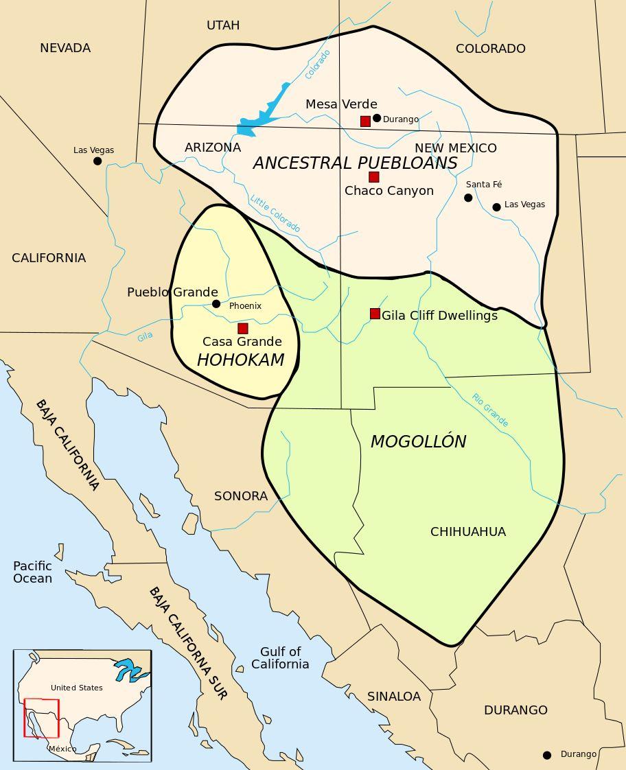
17 Southwest Complex Societies Chaco Canyon Snaketown Mesa Verde
18
19 Southwest Cultures Three main ceramic/ethnic/etc. groups developed Hohokam in southern Arizona, northern Mexico low desert Anasazi in the high desert four corners area Mogollon near the Mogollon rim, edge of the high plateau in central Arizona, and in eastern Arizona/western New Mexico
20 Hohokam In low desert by 300 AD, they were diverting river water into many canals to irrigate maize fields "basin and range" terrain, divided by parallel mountain ranges little rainfall, very hot in summer saguaro, barrel, cholla, prickly pear cactus mesquite, etc. in washes
21 Snaketown Example Hohokam site: Snaketown located in the Phoenix basin near the confluence of the Gila and Salt rivers early stage, starting around 300 AD maybe 100 people living in pithouses maize agriculture plus foraged foods arranged in pairs facing a common patio probably small family units by 600 AD, many more villages, rising regional population Snaketown grew, reaching 1 square kilometer by its peak at 900 AD maybe 125 pithouses, holding people
22 Snaketown, AZ A.D ( B.P.) It is believed that a group of people belonging to the ancient MesoAmerican cultures traveled north to settle in the area which is present-day southern Arizona. The Pima called these remarkable people the "Hohokam" meaning the "vanished ones." Ballcourts (Mesoamerican influence) 3 ceremonial mounds Structures, mounds, ballcourts around central plaza (Meso)

23 Excavations

24 Snaketown Ballcourt

25 Excavating the Ballcourt:


26 Hohokam Pottery

27 Reconstructed House 122/snaketown.htm
28 Courtyard Groups
29 Anasazi A widespread culture; we will focus on one dramatic variant within the larger Anasazi region Chaco Canyon in Northwestern New Mexico on the Colorado Plateau in one of the largest valleys cut into the high plain (over 1500 m / 5,000 ft) dry, only occasional, strong rains often causing flash floods in washes farmed by building low walls to catch the runoff, concentrate it, and direct it in channels to fields called "floodwater farming"
30 Chaco Canyon, NM A.D ( B.P.) Increase in population and complexity ca. A.D Area covers approx. 25,000 sq. miles Large towns, road and water systems Luxury/trade items at site. Desert Long winters, short growing season Carrying capacity ~5500 people
31 Basketmaker Period A.D. 490 First sedentary villages Pit houses, earth walled, mud & wood roofs. Storage huts behind houses. A.D Abandoned pit houses Move to surface dwellings Pithouse-Kivas (ceremonial)
32 Large Towns A.D. 900 (1100 B.P.) Penasco Blanco, Pueblo Bonito, Una Vida Rectangular rooms and round chambers Roofed with wooden beams Second story built on top Conglomeration of households or built with Master plan? All have at least one large kiva

33 Chetro Ketl

34 Casa Rinconada

35 Pueblo Bonito

36 Great Kiva, Pueblo Bonito

37 Pueblo de Arroyo

38 Canyon de Chelly Rover Dody Fugate, Assistant Curator, Archaeological Research Collections Museum of Indian Arts and Culture

39 Canyon de Chelly Sweety Dody Fugate, Assistant Curator, Archaeological Research Collections Museum of Indian Arts and Culture
40 Trade Pottery-elaborate designs Turquoise worked into finished ornaments. Source about 100 miles away. 60,000 turquoise fragments found in canyon alone. Outlying sites and roads. 70 communities outside canyon. 400 miles of roads 12 meters wide, cut 10 cm into soil.

41 Black on White

42 Turqoise

43
44 Cosmology Great North Road goes 40 miles north of canyon. Sacred landscape of roads.
45 Road Map

46 NASA Sat Photos
47 Road Functions The evaluation of the three general models of Chacoan road function suggest that the roads did not function to economically integrate the region. With the notable exception of the South Road between Chaco Canyon and Hosta Butte, none of the road segments in the study area extend more than a kilometer or two, and virtually none fall even close to cost-paths that minimize travel time between communities. In contrast, almost all roads appear to fit more closely with explanations that see the roads as having served localized religious, integrative, and/or political functions

48 Roads tend to connect great kivas and other ceremonial sites.
49 Mesa Verde, CO A.D ( B.P.) Better Environment, Natural Springs Cliff Dwellings Cliff House 220 rooms, 23 Kivas Ceremonial Temples (Fire & Sun Temple)

50 Cliff Palace

51 Spruce House


52 Square Tower
53 Mogollon The Mogollon Culture evolved in the southwestern corner of New Mexico and extended along the Mogollon Rim into east-central and southeast Arizona and southward into the Chihuahua region of northern Mexico.

54 Mogollon Area
55 Mogollon Traits The Mogollon seem to have developed from an earlier culture, the Cochise, an archaic culture of small nomadic bands who lived in the more mountainous parts of the territory. The introduction of pottery, probably from the south, signals the beginnings of the culture we call Mogollon. The people grew corn and beans, and were also hunters and gatherers. Villages consisted of small pithouse or pueblo groupings, and usually had a large ceremonial structure known as a kiva. A variety of burial practices were used, most often in shallow pit-graves either intramurally, (inside the dwellings), or in the refuse heaps surrounding the villages.
56 Mogollon Phases Georgetown Phase - AD This phase was characterized by San Francisco Red and the Alma Series plain wares, and San Lorenzo Red-on-Brown. Round deep pithouses were the norm.
57 Mogollon San Francisco Phase - AD This phase was also characterized by San Francisco Red and the Alma Series plain wares, with the addition of Mogollon Red-on-Brown and Three Circle Red-on-White types. Shallow rectangular pithouses with rounded corners were the norm.
58 Mogollon Three Circle Phase - AD During this phase San Francisco Red and the Alma Series plain wares became more rare, being replaced by the Reserve Plain and Corrugated wares. Puerco and Mimbres Black-on-Whites were developed. Shallow rectangular pithouses with rounded corners continued to be the norm.
59 Phases con d Reserve Phase - AD This phase was characterized by Reserve Black-on-White pottery. Pithouses were giving way to surface peublos.
60 Phases con d Tularosa Phase - AD This phase was characterized by Tularosa Black-on-White pottery, and by the introduction of polychrome types. Plain wares include Tularosa Fillet Rim and Tularosa Patterned Corrugated. Rectangular surface pueblos were now the norm.
61 Phases con d Mimbres Phase - AD This phase was characterized by Tularosa Black-on-White pottery, and by the introduction of polychrome types. Plain wares include Tularosa Fillet Rim and Tularosa Patterned Corrugated. Rectangular surface pueblos were now the norm.

62 Mogollon Mimbres Classic B/W Bowl ca C.E.
63 Three Rivers Petroglyphs site More than 21,000 glyphs of birds, humans, animals, fish, insects and plants, as well as numerous geometric and abstract designs are scattered over 50 acres of New Mexico's northern Chihuahuan Desert. Most of the petroglyphs here decorate a long, basalt ridge rising from the upper Tularosa Basin at the base of the Sacramento Mountains. Petroglyphs at Three Rivers were created by Jornada Mogollon people between about 900 and 1400 AD


64 Three Rivers Petroglyphs

65 Mogollon Pit House Reconstruction

66 Excavated pit house
67 Abandonment A.D (700 B.P.) 50 year drought beginning in A.D People abandoned large centers and dispersed. Why? Beginning of little ice age-changes in weather patterns Outside pressure, evidence of warfare.
A Continent of Villages. North American Societies before 1500
 A Continent of Villages North American Societies before 1500 The Resisted Revolution Adoption of farming was a gradual process that took hundreds of years. Not all Indian groups adopted agriculture. In
AP US History: An Essential Coursebook (2nd Ed)
") Unit One: Early Native and Colonial Societies (1491-1754) Chapter One: Pre-Columbian Societies AP US History: An Essential Coursebook (2nd Ed) Environment and Geography How did physical features affect
Unit One: Early Native and Colonial Societies (1491-1754) Chapter One: Pre-Columbian Societies AP US History: An Essential Coursebook (2nd Ed) Environment and Geography How did physical features affect
REEVALUATING THE MIMBRES COLLAPSE AT THE BLACK MOUNTAIN SITE
 REEVALUATING THE MIMBRES COLLAPSE AT THE BLACK MOUNTAIN SITE Kathryn J. Putsavage Southwestern New Mexico is famous for its pottery, the remarkable black-on-white bowls of the Mimbres phase (A.D. 1000-1150)
Downtown Phoenix yields a rare archaeological find
 Email this article Print this article Most popular pages Click to send Choose File Print or Ctrl P or Apple P Today This Week Downtown Phoenix yields a rare archaeological find As convention center rises,
IPCAS Board Meeting 7:00 pm. We welcome IPCAS member participation. Contact if you are interested in attending.
 CALUMET Newsletter of the Indian Peaks Chapter of the Colorado Archaeological Society February 2014 INDIAN PEAKS CALENDAR OF EVENTS Presentation (lecture) meetings are held in the University of Colorado
Following the initial soil strip archaeology is sprayed up prior to planning and excavation
 Barton Quarry & Archaeology Over the past half century quarries have been increasingly highlighted as important sources of information for geologists, palaeontologists and archaeologists, both through
archeological site LOS MILLARES
 archeological site LOS MILLARES Aerial view of the plain of Los Millares between the Rambla de Huéchar and the River Andarax The archaeological site of Los Millares is located in the township of Santa
2017 Arizona Sinagua and Lots More
 2017 Arizona Sinagua and Lots More This time we stayed in a house that was owned and decorated by an artist who works with metal, particularly iron. His pieces were located within and without his house.
The Mesoamerican cultures (1200BC- AD 1519)
") The Mesoamerican cultures (1200BC- AD 1519) Central America before the arrival of Europeans Click for Video There were many different cultures between 1200BC and AD 1519, but they share some important
The Mesoamerican cultures (1200BC- AD 1519) Central America before the arrival of Europeans Click for Video There were many different cultures between 1200BC and AD 1519, but they share some important
AP Art History Name. c. Name 2 types of sculpture produced by these people:
 Chapter 18: Native American Cultures before 1300 Chapter 35: Native American Cultures, 1300-1980 Vocabulary: Define or identify the following making sure you understand what they mean in discussing. 1.
The cultures and civilizations of the Americas
 The cultures and civilizations of the Americas Where did the Native Americans come from? Who was in Meso-America? ( Middle America ) Olmec Teotihuacan Maya Toltec Aztec Teotihuacan Temples Quetzalcoatl
Journeys of Discovery Travel Spirits of the Southwest May 1 7, 2018 With Gayle Lawrence - Journeys of Discovery Susan Duval - Susan Duval Seminars
 Journeys of Discovery Travel Spirits of the Southwest May 1 7, 2018 With Gayle Lawrence - Journeys of Discovery and Susan Duval - Susan Duval Seminars Canyon de Chelly AZ - Chaco Canyon NM - Mesa Verde
ARCHAEOLOGY IN TUCSON
 ARCHAEOLOGY IN TUCSON Vol.1, No.4 Newsletter of the Institute for American Research Summer 1987 TRULY THE ORIGINAL TUCSON! In our last AIT newsletter, we presented some of the background about the San
Discovery in the Americas?
 Discovery in the Americas? A Reading A Z Level W Quick Reader Word Count: 1,609 QUICK READER W Discovery in the Americas? Written by David Meissner Visit www.readinga-z.com for thousands of books and materials.
World History: Patterns of Interaction
 The Americans: A Separate World, 40,000 B.C. A.D. 700 Although early American civilizations remain mysterious, we know that the earliest Americans most likely migrated from Asia and that complex cultures
New Mexico: Chaco and DeChelly Canyons and Santa Fe Trip Notes April 15-26, 2016
 New Mexico: Chaco and DeChelly Canyons and Santa Fe Trip Notes April 15-26, 2016 Trip Notes are getting shorter and shorter! The itinerary tells much of the story and beyond that, well, there s simply
The Earliest Americans
 The Earliest Americans A Land Bridge Section The Earliest Americans The cultures of the first Americans, including social organization, develop in ways similar to other early cultures. The American Continents
Southwest Adventure: Canyons, Culture, Mesas and Trails Trip #1913 April 19 April 28, 2019
 Southwest Adventure: Canyons, Culture, Mesas and Trails Trip #1913 April 19 April 28, 2019 Four Corners Region Introduction The Four Corners region in the American Southwest is the heart of Native American
National Parks Called America s Best Idea
 National Parks Called America s Best Idea Welcome to This Is America in VOA Learning English. I'm Jim Tedder. And I'm Kelly Jean Kelly. This week on our program, we talk about national parks in the United
Jneneh in the Upper Wadi az-zarqa, in North Central Jordan, First Season 2011.
 Jneneh in the Upper Wadi az-zarqa, in North Central Jordan, First Season 2011. Khaled Douglas Jneneh is located in the north-western periphery of the city of Zarqa (grid ref. 250.88E 165.25N), in North
Ancient Civilizations of the Western Hemisphere. Maya, Aztec, & Inca
 Ancient Civilizations of the Western Hemisphere Maya, Aztec, & Inca THE MAYA The maximum extent of the Maya Maya - Location southern Mexico into northern Central America called the Yucatan Peninsula Maya
oi.uchicago.edu TALL-E BAKUN
 TALL-E BAKUN ABBAS ALIZADEH After I returned in September 1991 to Chicago from Cambridge, Massachusetts, I began preparing for publication the results of 1937 season of excavations at Tall-e Bakun, one
Social Studies: The World
 Social Studies: The World What is the name of the continent that is labeled #1 on the map? North America What is the name of the continent that is labeled #2 on the map? South America What is the name
INTRODUCTION ITINERARY PERU - THE SECRET OF THE INCAS TRIP CODE PETSTSI DEPARTURE. Daily DURATION. 7 Days LOCATIONS. Peru
 INTRODUCTION This tour is a suggested itinerary designed by our specialist team! Choose this itinerary or alter it to design your own Journey. Join us on this fantastic journey to the heart of the Incan
The Salt River by Elly Summer 2016
 The Salt River by Elly Summer 2016 After living in Arizona for many years, I only recently discovered the pleasure of kayaking and tubing. So far, I have been on the river below Saguaro Lake, on Saguaro
Taos Pueblo, New Mexico
 Taos Pueblo, New Mexico The Southwest Border Area Precipitation Climates of the US U.S. and Canada The Southwest Border Area A region of three dominating cultures: Native American, Spanish American, and
Chapter 7 Geography and the Early Settlement of Egypt, Kush, and Canaan
 Chapter 7 Geography and the Early Settlement of Egypt, Kush, and Canaan How did geography affect early settlement in Egypt, Kush, and Canaan? Section 7.1 - Introduction RF/NASA//Corbis This satellite photograph
Classical Era Variations: The Americas 500 BCE to 1200 CE. AP World History Notes Chapter 7
 Classical Era Variations: The Americas 500 BCE to 1200 CE AP World History Notes Chapter 7 Mesoamerica Meso = means middle Mesoamerica = stretches from central Mexico to northern Central America The Maya
ARCHAEOLOGY IN TUCSON
 ARCHAEOLOGY IN TUCSON Vol. 11, No. 2 Newsletter of the Center for Desert Archaeology Sprint 1997 Hidden Times: The Archaeology of the Tortolita Phase by William H. Doelle, Ph.D. and Deborah L. Swartz Center
CHIMNEY ROCK ARCHEOLOGICAL AREA
 CHIMNEY ROCK ARCHEOLOGICAL AREA Phone U.S. Forest Service, Pagosa Springs, Colorado at (303) 264-2268 for tour reservations and information SAN JUAN NATIONAL FOREST PAGOSA RANGER DISTRICT, ARCHULETA COUNTY,
Early Andean Civilizations. Origins and Foundations
 Early Andean Civilizations Origins and Foundations Environmental Context Basic divisions: east/west, north/south Mountains, deserts, and rivers Vertical archipelago : adapting to climate diversity based
New Mexico Ruins Explorations (M17A)
") New Mexico Ruins Explorations (M17A) I spent two weeks exploring northwestern New Mexico and adjacent areas in Arizona, Colorado and Utah. Much of this trip was focused on visiting ruins sites, many associated
New Mexico Ruins Explorations (M17A) I spent two weeks exploring northwestern New Mexico and adjacent areas in Arizona, Colorado and Utah. Much of this trip was focused on visiting ruins sites, many associated
The Mesoamerican Olmec, BCE
 Chapter 7: Peoples and Civilizations of the Americas, from 1200 BCE In a land with a shared culture, language, and religion, what remained a source of conflict for the Maya? What two specific regions compose
White Mountain Wilderness Trails
 The area in which these hikes are located is rugged high mountain country along the Mogollon Rim. This famous eastwest escarpment separates Arizona's high plateau from the basin and range below. These
U.S. National Forest Campground Guide
 U.S. National Forest Campground Guide Southwestern Region Arizona, New Mexico, Oklahoma and Texas National Forests and Grasslands in the Southwestern Region NF = National Forest NG = National Grassland
Preserving the Paragonah Fremont Site: A Model Public / Private Partnership
 Preserving the Paragonah Fremont Site: A Model Public / Private Partnership Presented by: Dr. James H. McDonald Dean of Humanities & Social Sciences Professor of Anthropology Southern Utah University Overview
Dinétah. Navajo Dinétah and Jémez Pueblo September 14-20, 2008
 1 Navajo Dinétah and Jémez Pueblo A Trip Report by Marian-Ortolf Bagley & Allan R. Brockway The Crow Canyon Archaeological Center is dedicated to understanding, teaching, and preserving the rich history
Big Sandy Ranch Mohave County, Arizona
 Big Sandy Ranch Mohave County, Arizona Photo [9] Deeded land on hillside within the River Ranch parcel Listed for sale exclusively by: Traegen Knight Headquarters West Ltd. PO BOX 1980 St. Johns, AZ 85936
100 Classic Hikes In Arizona By Scott S. Warren
 100 Classic Hikes In Arizona By Scott S. Warren Arizona: Hike Mount Humphreys Beyond the Edge - Hikers amid alpine tundra above timberline on Humphreys Trail in Forest and pick up 100 Classic Hikes in
Final Recreation Report. Sunflower Allotment Grazing Analysis. July 2015
 Final Recreation Report Sunflower Allotment Grazing Analysis July 2015 Table of Contents Introduction... 3 Affected Environment... 3 Four Peaks Wilderness Area... 3 Dispersed Recreation... 3 Environmental
Establishment of the Canyons of the Ancients National Monument
 versity and recognize the gay and lesbian Americans whose many and varied contributions have enriched our national life. IN WITNESS WHEREOF, I have hereunto set my hand this second day of June, in the
Egypt and the Nile River Valley System. SC Standards 6-1.3, 1.4, 1.5
 Egypt and the Nile River Valley System SC Standards 6-1.3, 1.4, 1.5 Where is Egypt? Egypt is on the continent of Africa. The River Nile runs through Egypt The capital of Egypt is Cairo Where is Egypt?
Ak-Chin Indian Community. Est. 1912
 Ak-Chin Indian Community Population: 575 (related to Tohono O odham and Akimel O'odham people) Size: 22,000 acres (34 sq miles) Industry: Agriculture, industrial park, ranching Attractions: Harrah s Ak-Chin
Ancient Egypt and the Near East
 *O*»f ' i ft Ancient Egypt and the Near East Chapter 7 Chapter 8 Chapter 9 Geography and the Early Settlement of Egypt, Kush, and Canaan The Ancient Egyptian P h a r a o h s Daily Life in Ancient Egypt
GUIDED HIKING. *Guests need to bring seasonally appropriate layers, hat, sun glasses, water bottle and sunscreen. Cancellation Policy
 GUIDED HIKING Hiking around Dunton into the beautiful San Juan Mountains is the quintessential wilderness experience. Trails lead you through exquisite high alpine basins blanketed in wildflowers amidst
Phoenix Habitat Restoration Projects
 Phoenix Habitat Restoration Projects Spur Cross Ranch Cave Creek (Estergard) Regional Tree and Shade Summit March 9, 2010 Desert Riparian Ecosystems Healthy riparian areas like this once existed along
One Source, Multiple Challenges: The Future Evolution of Water Policy and the Case of the Colorado River
 One Source, Multiple Challenges: The Future Evolution of Water Policy and the Case of the Colorado River David H. Getches Dean and Raphael J. Moses Professor of Natural Resources Law University of Colorado
Chapter 7. Geography and the Early Settlement of Egypt, Kush, and Canaan
 Chapter 7 Geography and the Early Settlement of Egypt, Kush, and Canaan Chapter 7 Geography and the Early Settlement of Egypt, Kush, and Canaan How did geography affect early in Egypt Kush, and Canaan?
TH E FIRST SEASON of investigations at the
 QUSEIR AL-QADIM Janet H. Johnson & Donald Whitcomb TH E FIRST SEASON of investigations at the ancient port of Quseir al-qadim on the Red Sea in Egypt took place in winter, 1978; the investigations were
oi.uchicago.edu Over a span of more than two decades, Oriental Institute expeditions have worked within the ruins of the ancient city of Nippur.
 oi.uchicago.edu Bedouin on Nippur mound Reconnaissance and Soundings in the Nippur Area ROBERT M C C. ADAMS, Field Director Over a span of more than two decades, Oriental Institute expeditions have worked
The Nile Valley For use with pages 38 46
 READING ESSENTIALS AND STUDY GUIDE 2-1 The Nile Valley For use with pages 38 46 Key Terms cataract: spot of rapid waters in a river (page 39) delta: area of fertile soil at a river s end (page 39) papyrus:
The Chalcolithic Period. Part I: The Ghassulian
 The Chalcolithic Period Part I: The Ghassulian The Chalcolithic Period Begins ca. 6500 BP (5000 BC) and ends with the Early Bronze Age (ca. 5500 BP or 3500 BC) Known for: Rise of Chiefdoms Pastoral Nomadism
4th Grade Third 9 Weeks Test
 4th Grade Third 9 Weeks Test Multiple Choice Identify the choice that best completes the statement or answers the question. 1 A waterway for ships that is dug across land is called a. A port C river B
Trench 91 revealed that the cobbled court extends further to the north.
 Report on the 2013 Gournia Excavations The 2013 excavations at Gournia were conducted June 17 July 26 under the aegis of the American School of Classical Studies at Athens and the supervision of the KD
What Is An Ecoregion?
 Ecoregions of Texas What Is An Ecoregion? Ecoregion a major ecosystem with distinctive geography, characteristic plants and animals, and ecosystems that receives uniform solar radiation and moisture Sometimes
Origins of Maya Culture. Preclassic Period. Cultural Roots. Keys to Maya Development. Middle Preclassic ( B.C.) Pacific coast region:
 Pacific coast region:") Origins of Maya Culture Preclassic Period Roots of Maya civilization begin in the Preclassic period, 2000 B.C A.D. 100. 2 regions active during this time: Southern highlands Central lowlands, or Peten
Origins of Maya Culture Preclassic Period Roots of Maya civilization begin in the Preclassic period, 2000 B.C A.D. 100. 2 regions active during this time: Southern highlands Central lowlands, or Peten
GUIDED HIKING. Cancellation Policy. Cancellations within 72 hours of the scheduled activity will result in full payment
 GUIDED HIKING Hiking around Dunton and the beautiful San Juan Mountains, is the quintessential wilderness experience. You ll walk through exquisite high alpine basins blanketed in wildflowers amidst high
INTRODUCTION 250,000
 INTRODUCTION The United States of America has over 250,000 rivers, with a total of about 3,500,000 miles of rivers. The main stems of 38 rivers in the United States are at least 500 miles (800 km) long.
Babylon. Ancient Cities by the River Lesson 5 page 1 of 6. Code of Hammurabi monument. E u p h. T i g r i s. r a t e s. Babylon, Mesopotamia
 Ancient Cities by the iver Lesson 5 page 1 of 6 1700s BCE, and established the importance of the city for the region He was responsible for a code of laws/decrees to reestablish justice in the land His
P U Y E MARK GOODMAN
 PUYE MARK GOODMAN PUYE Puye is one of the most extensive of the ancient Cliff Cities of the Southwest. It occupies an imposing situation on the Pajarito plateau, ten miles west of the village of Espanola
THE HISTORIC TRAINS OF COLORADO With Five Historic Rail Excursions September 13-20, 2018
 THE HISTORIC TRAINS OF COLORADO With Five Historic Rail Excursions September 13-20, 2018 8 DAYS TOUR HIGHLIGHTS & INCLUSIONS Roundtrip Airfare Deluxe Motorcoach Transportation 7 Nights Quality Accommodations
SIMON CANYON AREA OF CRITICAL ENVIRONMENTAL CONCERN (ACEC)
") SIMON CANYON AREA OF CRITICAL ENVIRONMENTAL CONCERN (ACEC) Activities: Facilities: Season / Hours: Description: Hiking, backpacking, fishing, picnicking, watchable wildlife. A graveled parking area, picnic
SIMON CANYON AREA OF CRITICAL ENVIRONMENTAL CONCERN (ACEC) Activities: Facilities: Season / Hours: Description: Hiking, backpacking, fishing, picnicking, watchable wildlife. A graveled parking area, picnic
Volunteer Expedition Trip Report Machu Picchu Sanctuary, Peru June 4-16, 2010
 Conservation Volunteers International Program P.O. Box 61912, Santa Barbara, California 93160 USA www.conservationvip.org Tel: 805.698.6915 Fax: 805.964.8612 A Non-Profit 501c3 Tax Exempt Organization
The Yingtianmen Gate-site of the Sui and Tang Eastern Capital in Luoyang City
 Nandajie The Yingtianmen Gate-site of the Sui and Tang Eastern Capital in Luoyang City Tang Luoyang City-site Archaeological Team, Institute of Archaeology, Chinese Academy of Social Sciences Key words:
Vocabulary Pre and Post Test
 Vocabulary Pre and Post Test Name Directions: Define each of the terms below in your own words. 1. archaeology: 2. petroglyph: 3. mean 4. median 5. conservation Vocabulary Pre and Post Test Answer Key
Climate. The Grand Canyon State. Established th State
 The Grand Canyon State Established 1912 48th State Arizona achieved statehood on Valentine's Day in 1912. The Grand Canyon is one of the Seven Wonders of the World. Lake Mead and Lake Mohave are two of
Maya, Aztec, and Inca Civilizations
 Maya, Aztec, and Inca Civilizations Mesoamerica Mesoamerica = Mexico & Central America Mesoamerica Some of the greatest civilizations in the Americas developed in Mesoamerica The Maya and Aztec lived in
8/20/2015 Flagstaff Water Use and Utilization Commission Collection, AHS ND.49
 Bookmark this page or copy and paste URL to Email message Flagstaff Water Use and Utilization Commission Collection, 1955 1967 AHS ND.49 Descriptive Summary Creator: Flagstaff (Ariz.) Flagstaff Water Use
THE POTTERY MOUND MONITORING PROGRAM, 2007
 THE POTTERY MOUND MONITORING PROGRAM, 2007 By David A. Phillips, Jr. Jean H. Ballagh Maxwell Museum Technical Series No. 6 Permit Nos. NM-07-202-S (survey and inventory), -M (monitoring), and -T (test
Physical. and. Human-made. Features
 Directions for Making a Geographic Features Vocabulary Book 1. Cut the photographs boxes out of page 2 and sort the them into two groups: physical features and human-made features. 2. Correctly match each
The Parthian newfound area review in the central part of the Iranian Plateau: Ravanj-e Josheghan-e ghali
 International Research Journal of Applied and Basic Sciences 2015 Available online at www.irjabs.com ISSN 2251-838X / Vol, 9 (9): 1517-1521 Science Explorer Publications The Parthian newfound area review
Peru. Classic. 7 days. Say YES to adventure and discover the best of Peru! VVVV
 Peru 7 days Say YES to adventure and discover the best of Peru! VVVV Classic ITINERARY Highlights Do you want to discover most of Peru, but don t have a lot of time? Then this tour will fit your expectations
Lesson 8 Wilderness: Human Uses, Past and Present
 Lesson 8 Wilderness: Human Uses, Past and Present Objectives: Students will: recognize that cultural resources are part of Wilderness and that these resources provide information about how the area was
Lesson 1: Land and Climate of the West Land and Water of the West 1. There are 13 states in the West, divided into 3 regions a. Southwest: Nevada,
 Lesson 1: Land and Climate of the West Land and Water of the West 1. There are 13 states in the West, divided into 3 regions a. Southwest: Nevada, Utah, Arizona, New Mexico b. Mountain States: Wyoming,
HOW IT ALL BEGAN THE DESERT FOOTHILLS CHAPTER ARIZONA ARCHAEOLOGICAL SOCIETY. Sites AZU:1:4, AZU:1:5, and AZU:1:6
 HOW IT ALL BEGAN THE DESERT FOOTHILLS CHAPTER ARIZONA ARCHAEOLOGICAL SOCIETY This report makes a best effort at providing the history and background of the Desert Foothills Chapter, Arizona Archaeological
Bryce Canyon Country.
 Bryce Canyon Country Backways Itinerary - Grand Staircase, Capitol Reef Region Grand Staircase/Capitol Reef/Henry Mountains Adventure off the beaten path and revel in the beauty of Utah s scenic backways.
Santa Fe IPDPS 2004 International Parallel & Distributed Processing Symposium
 Santa Fe IPDPS 2004 International Parallel & Distributed Processing Symposium WELCOME TO SANTA FE! Santa Fe Destinations welcomes the participants of IPDPS 2004 to Santa Fe! Santa Fe Destinations is the
INTRODUCTION ITINERARY PERU - CUSQUENITA (LITTLE CUSCO) TRIP CODE PETSCUS DEPARTURE. Daily DURATION. 4 Days LOCATIONS. Peru
 TRIP CODE PETSCUS DEPARTURE. Daily DURATION. 4 Days LOCATIONS. Peru") INTRODUCTION This tour is a suggested itinerary designed by our specialist team! Choose this itinerary or alter it to design your own Journey. On a limited time frame, or want to visit the Cusco region
INTRODUCTION This tour is a suggested itinerary designed by our specialist team! Choose this itinerary or alter it to design your own Journey. On a limited time frame, or want to visit the Cusco region
Chapter 4. Ancient Egypt and Kush Section 1: Geography & Ancient Egypt
 Chapter 4 Ancient Egypt and Kush Section 1: Geography & Ancient Egypt The gift of the nile Geography played a key role in the development of the Egyptian civilization. The Nile River brought life to Egypt.
Chapter 6. Early Societies in the Americas and Oceania. 2011, The McGraw-Hill Companies, Inc. All Rights Reserved.
 Chapter 6 Early Societies in the Americas and Oceania 1 Early Mesoamerican Societies, 1200 B.C.E.-1100 C.E. 2 Origins of Mesoamerican Societies Migration across Bering land bridge? Probably 13,000 B.C.E.,
Oak Creek Ranch Near Sedona, AZ
 Oak Creek Ranch Near Sedona, AZ 1165 E. WILLOW POINT ROAD, CORNVILLE, ARIZONA For nearly half a century David Wick Sr. and his family operated the Oak Creek Ranch School. Thousands of kids have benefited
EXPLORING EARTH S SURFACE. Lesson 4
 EXPLORING EARTH S SURFACE Lesson 4 Introduction Lewis and Clark In 1804, an expedition set out from near Saint Louis to explore the land between the Mississippi River and the Pacific Ocean, The United
Utah Nevada California Arizona New Mexico Baja California Texas Sonora Chihuahua Coahuila de Zaragoza Sinaloa Durango Nuevo León Zacatecas San Luis
 Nevada Utah California Arizona New Mexico Baja California Sonora Texas Chihuahua Coahuila de Zaragoza Sinaloa US States Mexico States International Boundary Durango Nayarit Zacatecas Jalisco Nuevo León
Archaeologists for Hire: An In-Class Activity
 Archaeologists for Hire: An In-Class Activity Beyond Grades: Capturing Authentic Learning Conference Welcome to the Marveloso Valley, a fictional valley on the central coast of Peru. Over the decades,
PROPOSED PROGRAM ITINERARY: (refinements may occur after the field trip pre-run) NORTHEAST ARIZONA
 NORTHEAST ARIZONA") ABF FIELD TRIP LEADER: Paul Remeika ABF TOUR COORDINATOR: Joan Carskaddan MEMBERS ONLY TOUR PRICE $1795/Person, Singles Add $350 PROPOSED PROGRAM ITINERARY: (refinements may occur after the field trip
ABF FIELD TRIP LEADER: Paul Remeika ABF TOUR COORDINATOR: Joan Carskaddan MEMBERS ONLY TOUR PRICE $1795/Person, Singles Add $350 PROPOSED PROGRAM ITINERARY: (refinements may occur after the field trip
New Studies in the City of David The Excavations
 The 2013-2014 Excavations Israel Antiquities Authority The intensive archaeological work on the city of David hill during the period covered in this article has continued in previously excavated areas
The Desert Southwest. The Desert Southwest OVERVIEW. Regional Landscape Studies. Desert Southwest 5/6/2016 DATES TO REMEMBER
 DATES TO REMEMBER May 2: Course evaluation period begins. Check your Hunter e-mail for instructions. Use your Hunter netid and password: Smartphone: www.hunter.cuny.edu/mobilete Computer: www.hunter.cuny.edu/te
Region 1 Piney Woods
 Region 1 Piney Woods Piney Woods 1. This ecoregion is found in East Texas. 2. Climate: average annual rainfall of 36 to 50 inches is fairly uniformly distributed throughout the year, and humidity and temperatures
IMTO Italian Mission to Oman University of Pisa 2011B PRELIMINARY REPORT (OCTOBER-DECEMBER 2011)
") IMTO Italian Mission to Oman University of Pisa 2011B PRELIMINARY REPORT (OCTOBER-DECEMBER 2011) The 2011B research campaign took place in the area around Salut from October, 19 th, to December, 16 th.
IMTO Italian Mission to Oman University of Pisa 2011B PRELIMINARY REPORT (OCTOBER-DECEMBER 2011) The 2011B research campaign took place in the area around Salut from October, 19 th, to December, 16 th.
The City-Wall of Nineveh
 The City of Nineveh Nineveh has a very long history, with finds dating already back at fifth millennium. As part of the Assyrian empire, the city served as a regional center during the Middle and Early
BRYCE CANYON COUNTRY Boulder Mountain Scenic backways itinerary
 BRYCE CANYON COUNTRY Boulder Mountain Scenic backways itinerary Boulder Mountain Area The high plateaus of the Aquarius Plateau (Boulder Mountain), are heavily forested and covered in countless winding
Architectural Analysis in Western Palenque
 Architectural Analysis in Western Palenque James Eckhardt and Heather Hurst During the 1999 season of the Palenque Mapping Project the team mapped the western portion of the site of Palenque. This paper
aiton.new 1/4/04 3:48 AM Page 2
 aiton.new 1/4/04 3:48 AM Page 2 Below: An aerial view of area A of the excavations. A massive square building that appears to be a fortress was discovered in this area at the top of the tell. aiton.new
Mazatzal Wilderness Trail Maintenance and Exploration
 Mazatzal Wilderness Trail Maintenance and Exploration March 15-19 (Wednesday - Sunday) Difficulty: Beginner Camping: Car Camping Mileage: Wednesday ~4 miles Thursday ~4-6 miles Friday ~4-6 miles Saturday
North-East New Mexico September October 2012
 North-East New Mexico September October 2012 Pecos National Historical Park As visitors walk about Pecos National Historical Park in northeastern New Mexico at least three different, though related, histories
INTRODUCTION ITINERARY PERU - CUSCO & MACHU PICCHU DISCOVERY TRIP CODE PETSCMD DEPARTURE. Daily DURATION. 5 Days LOCATIONS. Cusco and Machu Pichu
 INTRODUCTION This tour is a suggested itinerary designed by our specialist team! Choose this itinerary or alter it to design your own Journey. We have taken the highlights of Cusco and squeezed them into
POINTE HILTON SQUAW PEAK RESORT THE FACTS
 POINTE HILTON SQUAW PEAK RESORT THE FACTS Nestled in the slopes of the Phoenix Mountains Preserve, Pointe Hilton Squaw Peak Resort invites you to experience the warmth of our hospitality, the pleasure
FLY FISHING. Half Day $400 for one person -or- $275 per person for 2+ people Full Day $550 for one person -or- $350 per person for 2+ people
 FLY FISHING Enjoy classic western fly fishing on the West Fork of the Dolores River. Both the Dunton Hot Springs and Dunton River Camp offer anglers a combination of meadow oxbows and pocket water canyons.
Mesoamerican Civilizations
 Mesoamerican Civilizations Human Migration Turn to page 237 and answer the two geography skillbuilder questions: What two continents does the Beringia land bridge connect? From where do scholars believe
INTRODUCTION ITINERARY PERU - CUSCO & MACHU PICCHU DISCOVERY TRIP CODE PETSCMD DEPARTURE. Daily DURATION. 5 Days LOCATIONS. Cusco and Machu Pichu
 INTRODUCTION This tour is a suggested itinerary designed by our specialist team! Choose this itinerary or alter it to design your own Journey. We have taken the highlights of Cusco and squeezed them into