Minehead Seafront - Analysis
|
|
|
- Sybil Armstrong
- 5 years ago
- Views:
Transcription


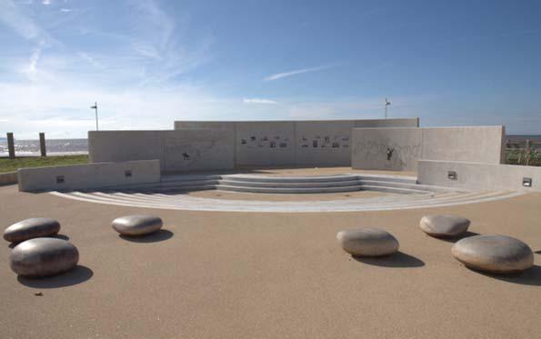
1 Minehead Seafront - Analysis Existing Constraints Part of Jubilee Gardens is in the Wellington Square Conservation Area. Area east of Jubilee Gardens contains Wessex Water infrastructure and manholes which must stay. Existing clock to stay. Existing human sundial-may need to stay? Existing flag poles-may need to stay? Existing shelters to stay. Existing bucket and spade sculptures to stay-could be relocated? Maritime Mile 2m adjacent to sea wall to be built in. Existing lights-may need to stay? Site Area Existing Problems Existing seats in variable condition and too low for good views over the sea wall. Large open areas of tarmac are unattractive, although coloured aggregate is high quality. Lots of signage and railing clutter. Existing lighting not interesting. Lack of activities/ range of recreation options. Nothing for young families. Exposed with wind blown sand in some areas. Clutter of bins, torpedos. Some seats damaged by skateboarders. Enterprising Minehead Report - Seafront Analysis


2 Minehead Seafront - Analysis Photographs Torpedo features unappealing to today s visitor. Open and exposed. Service trench patched through red tarmac with black tarmac. Could a more attractive way be found of protecting this drop? Wall drop not protected here. Signage clutter.


3 Minehead Seafront - Analysis Photographs What are the spades for? are they bike racks? can they be used more imaginatively? Seating area and windvane has a municipal feel. Could be better integrated with the promenade. Wall drop not protected here-less than 0.9m does not need to be. Signage and railing clutter.


4 Minehead Seafront - Analysis Photographs Not much defi nition to paving colours at sundial. Seating municipal. Seating noisy, by road and has no views of the sea. Green tarmac overlay worn out. Signage and railing clutter.


5 Minehead Seafront - Analysis Photographs Wessex Water infrastructure. Visual clutter. Concrete Minehead Art seats quite nice - could be retained or reused elsewhere. Visual clutter.
6 Minehead Seafront - Analysis Diagram Boulders Area dominated by manholes and service box LB Shelters TCB Outfall Shelter Clock 7.5m PC Shelter in poor condition Sundial Boulders Breakwater Flag pole Sundial OK, seating unexciting Mean High Water Area cluttered with signage, narrow, steps, close to raod Sand Boulders Boulders Breakwater Flag pole Seating area with weather vane, dull Seat level low with poor views over sea wall Sand Seats very regular/ unexciting. Large areas of tarmac Low stone wall with ugly railing Area here cluttered Engine Shed Queen's Hall Information WARREN ROAD View Sea Wall 7.3m Bol Seats here badly located, close to road, noisy, no views 1 to 14 Halyard Place Clipper Quay Bol Custom House Low stone wall, no rail KEY Spade sculptures regularly spaced Wellington Square Conservation Area Existing linear band of seats and lights Existing tree retained Proposed development site Seafront access point Maritime Mile trail with approved sculpture location General Area Experience (text describes this)
7 Minehead Seafront - Enterprising Minehead Masterplan This report contains some valuable initial concept work which needs to be reviewed. Relevant concepts should be incorporated into the ongoing development proposals.


8 Minehead Seafront - Developing Themes and Ideas


9 Minehead Seafront - Developing Themes and Ideas
Minehead Seafront Refurbishment Survey Analysis
 Minehead Seafront Refurbishment Survey Analysis Survey Returns: From Online Survey Monkey site Respondents: 143 https://www.surveymonkey.com/results/sm-jy7lq58ll/ From Online Survey Monkey site Respondents:
M E S T I Z O C U R T I S P A R K
 ARAPAHOE CONNECTION TO BUS ROUTE AT ND AND LAWRENCE, FUTURE LIGHT RAIL STATION LEGEND SOCIAL TRAIL FLAGSTONE PAVING TO RESTORE/MAINTAIN CONCRETE PAVING DIAGONAL CURVILINEAR SOCIAL ROUTE IS OUT OF HISTORIC
HARBOUR EDGE STITCH. Uniting the Waterfront with the City Centre
 78 AC_BEU_CCMP_2_TM1_4 _FD.indd 78 20/07/12 12:04 PM 01 HARBOUR EDGE STITCH Uniting the Waterfront with the City Centre 01 VISION OUR 2032 VISION IS: Quay Street as a high-quality Harbour Edge space that
2018 Airport Master Plan Overview of Development Concepts. Greg Ballentine (WSP)
") 2018 Airport Master Plan Overview of Development Concepts Greg Ballentine (WSP) Thank You Stakeholder and community consultation has included discussions with over 40 stakeholder groups including airport
2018 Airport Master Plan Overview of Development Concepts Greg Ballentine (WSP) Thank You Stakeholder and community consultation has included discussions with over 40 stakeholder groups including airport
Welcome to the future of Terwillegar Park a Unique Natural Park
 Welcome to the future of Terwillegar Park a Unique Natural Park 1 Introduction The Terwillegar Park Concept Plan study will develop an overall concept plan, management objectives and development guidelines
Queen Elizabeth II Diamond Jubilee Herne Bay Coastal Park Action Plan. Kings Hill slopes, Beacon Hill, The Downs, Bishopstone Glen and Reculver
 Appendix 3 Queen Elizabeth II Diamond Jubilee Coastal Park Action Plan Kings Hill slopes, Beacon Hill, The, Bishopstone Glen and Reculver This area moves from the commercial centre of the Coastal Park
WORKING DRAFT (DECEMBER 2016) - FOR COMMUNITY REVIEW BY
 - FOR COMMUNITY REVIEW BY") PURPOSE The purpose of this Working Draft Spatial Framework summary is to facilitate additional public and stakeholder feedback following the public meetings and reference group workshops held in November
PURPOSE The purpose of this Working Draft Spatial Framework summary is to facilitate additional public and stakeholder feedback following the public meetings and reference group workshops held in November
CHAPTER 5. Chapter 5 Recreation Element
 CHAPTER 5 Recreation Element Chapter 5 Recreation Element The Recreation Element of the Meyers Area Plan is a supplement to the Recreation Element of the TRPA Regional Plan and the El Dorado County General
Kirkcaldy Sea Wall Improvements. Non-technical Summary. For illustration purposes only to give an indicative representation of the scheme.
 ENVIRONMENTAL STATEMENT Non-technical Summary For illustration purposes only to give an indicative representation of the scheme. Kirkcaldy Sea Wall Improvements Introduction A concrete sea wall fronts
Review of Highcliffe Shopping Centre
 Review of Highcliffe Shopping Centre A Summary M W Mawbey 15 th December 2013 INTRODUCTION Concern for the health of high streets is common theme across the country. High streets have been affected by
Those with Interest in the City of Cambridge Trail System
 Community Services Department City Hall 50 Dickson Street, P.O. Box 669 Cambridge ON N1R 5W8 Tel: 519-740-4681 July 20, 2010 To: Re: Those with Interest in the City of Cambridge Trail System City of Cambridge
Chapter 6. Trail Design. Trail Design
 Chapter 6 Trail Design Trail Design The trail winds through a region rich in scenic beauty, cultural, and natural history. Volunteer landscape architects working with the Core and Planning Teams, have
Fostering Long Term Initiatives in Ports
 Fostering Long Term Initiatives in Ports Overview of Project In November 2012, CCC joined as a UK partner in the Interegg IV(A) France (Channel)- England territorial Cooperation Programme - objective to
Corktown Parks. Public Meeting. City of Toronto
 Corktown Parks Public Meeting City of Toronto 15-04-20 Agenda 1. Reasons for Study 2. Consultation to Date 3. Parks Evaluation 4. Community Context 5. Bright St. Playground 6. Orphans Green (Dog Off Leash)
1 PROJECT STATUS UPDATE 2 ND CONCESSION FROM BRISTOL ROAD TO DOANE ROAD TOWNS OF EAST GWILLIMBURY AND NEWMARKET
 Report No. 3 of the Regional Council Meeting of March 28, 2013 1 PROJECT STATUS UPDATE 2 ND CONCESSION FROM BRISTOL ROAD TO DOANE ROAD TOWNS OF EAST GWILLIMBURY AND NEWMARKET The recommends: 1. Receipt
Birthplace of the Oil Industry Trail Town Crawford County, Pennsylvania. for the Titusville Redevelopment Authority.
 TITUSVILLE Birthplace of the Oil Industry - 1895 Trail Town - 2013 City of Titusville Fleming Park Crawford County, Pennsylvania for the Authority By: STIFFLER McGRAW Engineers Surveyors Architects & TABLE
PLACE RECORD FORM CITY OF MELVILLE, WESTERN AUSTRALIA LOCAL GOVERNMENT INVENTORY PLACE REFERENCE NO.: BN06 REINSTATE + NEW LISTINGS
 CITY OF MELVILLE, WESTERN AUSTRALIA PLACE RECORD FORM LOCAL GOVERNMENT INVENTORY PLACE REFERENCE NO.: BN06 REINSTATE + NEW LISTINGS NAME: POINT WALTER RESERVE, including POINT WALTER GOLF COURSE and BLACKWALL
Auburn Trail / Ontario Pathways Trail Connector Feasibility Study Public Information Meeting Wednesday, August 22, 2012
 Auburn Trail / Ontario Pathways Trail Connector Feasibility Study Public Information Meeting Wednesday, August 22, 2012 Purpose of Feasibility Study Purpose Evaluate the feasibility of constructing a multiuse
DRAFT. Dorabelle Campground Rehabilitation
 DRAFT Dorabelle Campground Rehabilitation September 2012 1.1 REGIONAL SETTING AND PROJECT LOCATION The Dorabelle Campground is located on the western shore of Shaver Lake in Fresno County, California (Section
Fremantle Railway Station
 Submission to Planning and Infrastructure Minister Alannah MacTiernan December 2005 Fremantle Railway Station Celebrating its centenary in 2007 The Fremantle Railway Station below opened in 1907, the same
NORTH OF BROADWAY SECTION CONTENTS: COTTAGE PARK FARVIEW PARK GLEN GALE PARK IRVING TRIANGLE JORDAN PARK NEWTON PARK PERKINS HILL PARK
 NORTH OF BROADWAY SECTION CONTENTS: COTTAGE PARK FARVIEW PARK GLEN GALE PARK IRVING TRIANGLE JORDAN PARK NEWTON PARK PERKINS HILL PARK N ILIO NA VE N JAM ES AV E PLAYGROUND PAR K PRO PER TY B OUN DAR Y
Hudson Highlands Fjord Trail Draft Master Plan. April 29, 2015
 Hudson Highlands Fjord Trail Draft Master Plan April 29, 2015 Agenda Route Overview Proposed Segment Results of Community Survey on that Segment Next Steps Municipal Endorsement Environmental Review Implementation
Re-integrate the River Torrens
 1 Re-integrate the River Torrens The river is a landmark of Adelaide and is fortunate to have a wide selection of public spaces on its banks. The River Torrens is a special part of Adelaide, which needs
Perth and Kinross Council Development Management Committee 20 February 2013 Report of Handling by Development Quality Manager
 Perth and Kinross Council Development Management Committee 20 February 2013 Report of Handling by Development Quality Manager 4(4)(ii) 13/80 Replacement and re-positioning of street furniture, The Birks,
Our brand is our identity and enables us to build and maintain our profile within the areas we work. This guide will help you create the materials we
 Brand Guidelines. Our brand is our identity and enables us to build and maintain our profile within the areas we work. This guide will help you create the materials we use to communicate with our colleagues,
WHERE DID WE COME FROM? WHERE ARE WE NOW? WHERE DO WE WANT TO BE?
 WHERE DID WE COME FROM? WHERE ARE WE NOW? WHERE DO WE WANT TO BE? The Riverside Industrial City Improvement District (CID) Journey We reflect on how it all started, celebrate the change that we have already
Concept Curtin Precinct Map and Code
 Concept Curtin Precinct Map and Code Proposed changes from the revised Curtin Group Centre Draft Master Plan recommendations Disclaimer: This document is intended to show the proposed changes to the existing
Millport Charrette. Moving forward What do you think? Where are the opportunities? What are the priorities?
 Millport Charrette North Ayrshire Council invite you to share your views on marine tourism opportunities at Millport. North Ayrshire Council s Economy and Communities Team is keen to further develop Millport
SANDY BAY RETAIL PRECINCT STREETSCAPE REVITALISATION - PALM TREES AND BANNER POLES - RESPONSE TO PETITION
 Page 41 REPORT TITLE: SANDY BAY RETAIL PRECINCT STREETSCAPE REVITALISATION - PALM TREES AND BANNER POLES - RESPONSE TO PETITION REPORT PROVIDED BY: Road Services Engineer Director City Infrastructure 1.
Environmental Development of River Road Ranch
 Environmental Development of River Road Ranch New Braunfels, Texas Alix Scarborough GEO 3426 April 2012 Introduction The 2,400-acre Word-Borcher ranch has been owned by the Word family since 1941. Located
Dungeness Recreation Area County Park Master Plan
 Dungeness Recreation Area County Park Public Outreach Meeting October 10, 2007 Project Overview USFWS Site Dungeness Recreation Area County Park Meeting Objectives: Re-Introduce project; provide status
Rating: 5.0 (scale of 1-10)
") 95 Community Trail System Groundcover: 2-metre paved path, 1- metre grass buffer on either side. Location: Fort St. John Ownership: City of Fort St. John Rating: 5.0 (scale of 1-10) Strategic value: Linear
95 Community Trail System Groundcover: 2-metre paved path, 1- metre grass buffer on either side. Location: Fort St. John Ownership: City of Fort St. John Rating: 5.0 (scale of 1-10) Strategic value: Linear
PART VIII APPLICATION FOR REVISED SOUTH SIDE TRAFFIC MANAGEMENT WORKS TO FACILITATE LUAS BXD PLANNING REPORT ROADS & TRAFFIC DEPARTMENT
 PART VIII APPLICATION FOR REVISED SOUTH SIDE TRAFFIC MANAGEMENT WORKS TO FACILITATE LUAS BXD PLANNING REPORT ROADS & TRAFFIC DEPARTMENT NOVEMBER 2012 1.0 INTRODUCTION This report has been prepared in support
Weymouth Promenade Lighting
 Weymouth Promenade Lighting Dorset Coastal Connections Community Consultation Summary 1. Background The Weymouth Promenade Lighting project will create a new artist-designed lighting scheme along Weymouth
Dunsmuir Community Park
 Dunsmuir Community Park Master Plan September 2016 ENGAGEMENT SUMMARY #2 Introduction Public engagement is integral to the development of the Dunsmuir Community Park Master Plan. Two park open houses were
Corabelle Park. Inventory. Future Development
 Corabelle Park Size: Approximately 4 acres Site Description: Corabelle Park is a relatively new park within the Murray County Park System. It is located on the south side of Corabelle Lake just off gravel
Beaver Creek Provincial Park. Management Plan
 Beaver Creek Provincial Park Management Plan 2 Beaver Creek Provincial Park Table of Contents 1. Introduction... 3 2. Park History... 3 3. Park Attributes... 4 3.1 Natural... 4 3.2 Recreational... 4 4.
MUNICIPALITY OF ANCHORAGE
 MUNICIPALITY OF ANCHORAGE ANCHORAGE PARKS & RECREATION Memorandum PRC 08-56 DATE: 5 August 2008 TO: FROM: SUBJECT: Parks & Recreation Commission Holly Spoth-Torres, Park Planner PRC 08-56 Far North Bicentennial
Kelly Motorized Trails Project Proposed Action
 Kelly Motorized Trails Project Proposed Action November 28, 2011 The Flagstaff Ranger District of the Coconino National Forest is seeking public input on the proposed Kelly Motorized Trails Project (formerly
Villages at Buffalo Run East
 Villages at Buffalo Run East Neighborhood Park Subhead to title page goes here. Public Design Meeting April 9, 2015 Capital Improvement Program Commerce City s $137 million CIP is the result of a 2013
OLD AIRPORT (PFN) RW 05/23 RW 14/32. 4,884-FEET X 150-FEET MIRL 4-BOX VASIs (5 & 23 APPROACHES) REILS
 RW 05/23 RW 14/32. 4,884-FEET X 150-FEET MIRL 4-BOX VASIs (5 & 23 APPROACHES) REILS") FAITH ADAMS AGENDA AIRPORT RELOCATION CHALLENGES AIRFIELD LIGHTING & SIGNAGE NAVAIDS AIRFIELD LIGHTING VAULT L-890 ALCMS AIR TRAFFIC CONTROL TOWER (ATCT) CONCLUSION AIRPORT RELOCATION OLD AIRPORT (PFN)
FAITH ADAMS AGENDA AIRPORT RELOCATION CHALLENGES AIRFIELD LIGHTING & SIGNAGE NAVAIDS AIRFIELD LIGHTING VAULT L-890 ALCMS AIR TRAFFIC CONTROL TOWER (ATCT) CONCLUSION AIRPORT RELOCATION OLD AIRPORT (PFN)
REVISED PLANNING PROPOSAL Volume syw082 Station Stret, Menangle
 REVISED PLANNING PROPOSAL Volume 2 2013syw082 Station Stret, Menangle Part 4 Mapping Existing Controls in the Wollondilly LEP 2011 affecting the Site Zone / Standard Zone Control The land is zoned RU1
National Park Authority Board Meeting
 Paper for decision 1. Introduction 1.1 Preparations for the introduction of four Camping Management Zones (covering less than 4% of the National Park) have progressed significantly since Scottish Ministers
PROPOSED PARK ALTERNATIVES
 8 Chimne y Rock State Park M a ster Pl an 2011 PROPOSED PARK ALTERNATIVES Introduction Three different park development concepts were prepared and presented to the citizens of North Carolina through a
NORTHWEST SECTION CONTENTS: CLEVELAND PARK FOLWELL PARK RYAN LAKE PARK VICTORY PRAIRIE DOG PARK VICTORY PARK
 NORTHWEST SECTION CONTENTS: CLEVELAND PARK FOLWELL PARK RYAN LAKE PARK VICTORY PRAIRIE DOG PARK VICTORY PARK LUCY LANEY COMMUNITY SCHOOL N 33RD AVE N 33RD AVE SINGLE-FAMILY RESIDENTIAL MULTI-USE DIAMOND
SUSTAINABLE TOURISM A DEVELOPMENT PLAN FOR EASTBOURNE. PRESENTED BY DEAN PUTLAND & DANIEL WHEATLEY. FROM RATTON SCHOOL IN THE UNITED KINGDOM
 SUSTAINABLE TOURISM A DEVELOPMENT PLAN FOR EASTBOURNE. PRESENTED BY DEAN PUTLAND & DANIEL WHEATLEY. FROM RATTON SCHOOL IN THE UNITED KINGDOM Eastbourne is found on the south coast of the UK, and is about
35 Bee Tree Park Planning Zone 3
 35 Bee Tree Park Planning Zone 3 2701 Finestown Road Visit Date: August 2016 St. Louis County Parks Master Plan Page 1 35 Bee Tree Park 2701 Finestown Road St. Louis County Parks Master Plan Planning Zone
Concord Road Interchange. Standard hours of work
 Artist impression of the Concord Road interchange, Concord - concept only WestConnex s M4 East will extend the M4 Motorway with two new 5.5 kilometre tunnels from Homebush to Haberfield, providing a bypass
Waterfront Concept Plan: Community Survey Summary
 Waterfront Concept Plan: Community Survey Summary Published April 20, 2016 #1100085 Introduction The survey was one component of the public consultation process endorsed by Council in October, 2015. This
NEWBORO AND PORTLAND HARBOUR REDVELOPMENT PLANS
 INTRODUCTION The Municipal docks in both Newboro and Portland were transferred to the Township of Rideau Lakes by Parks Canada in 2002. Little has been done to improve the docks physical condition or role
The reasons why coastal management is needed in Minehead:
 1. Resource 1: Why did Minehead need new sea defences? Coastal management in Minehead In pairs, read the following resource and highlight the reasons why coastal management was needed in Minehead. The
Proposal to Redevelop Lower Kananaskis River-Barrier Lake. Bow Valley Provincial Park. Frequently Asked Questions
 Proposal to Redevelop Lower Kananaskis River-Barrier Lake Bow Valley Provincial Park Frequently Asked Questions What is being proposed? What are the details of the proposal? Where is the project area located?
THAT the Board approve the final proposed concept plan for the Jericho Marginal Wharf site as shown in Figure C-4 of Appendix C.
 Date: January 17, 2012 TO: Board Members Vancouver Park Board FROM: General Manager Parks and Recreation SUBJECT: Jericho Marginal Wharf Phase 2 Concept Plan RECOMMENDATION THAT the Board approve the final
TREASURE ISLAND AND YERBA BUENA ISLAND Treasure Island Development Authority Board. April 8, 2015
 TREASURE ISLAND AND YERBA BUENA ISLAND Treasure Island Development Authority Board April 8, 2015 AGENDA Ongoing Engineering & Design Activities Upcoming Construction Activities TREASURE ISLAND TIDA Board
Port Macquarie-Hastings Pedestrian Access and Mobility Plan. Working Paper COMMUNITY ENGAGEMENT
 Port Macquarie-Hastings Pedestrian Access and Mobility Plan Working Paper COMMUNITY ENGAGEMENT December 2014 Table of Contents Table of Contents... 2 1 Introduction... 3 2 Submissions... 3 2.1 Stakeholder
Northaven Trail Phase 2 Initial Project Overview
 Northaven Trail Phase 2 Initial Project Overview Partnership Project to extend existing Northaven Trail Improve Bike/Ped Connectivity On Dallas Trail Network Plan City and County Funding Oncor Texas Trails
Stittsville Parks Information Session
 Stittsville Parks Information Session Amberway Park, Blackstone Park, Bryanston Gate Park & William Bradley Park Thursday, February 8, 2018 Open House 6:30-8:45pm Presentation 7pm Goulbourn Recreation
State of the Airport Robert S. Bowen, Executive Director October 18, 2018
 Robert S. Bowen, Executive Director October 18, 2018 A Year of Change The last year will be remembered as a period when the airlines, bolstered by a growing national economy, moderate fuel prices and changing
Former Middle School Site Green Space & Brecksville Road Streetscape. March 27, 2018
 Former Middle School Site Green Space & Brecksville Road Streetscape March 27, 2018 Brecksville Streetscape & Downtown Greenspace Project Schedule City of Indepenence 2017 2018 Meeting Schedule Tasks/Deliverables
Uniclass L534+L212. August home zones. paving PRECAST CONCRETE PAVING SOLUTIONS FOR TODAY S RESIDENTIAL STREET ENVIRONMENTS.
 August 2005 Uniclass L534+L212 paving home zones PRECAST CONCRETE PAVING SOLUTIONS FOR TODAY S RESIDENTIAL STREET ENVIRONMENTS www.paving.org.uk Home Zone Principles Home Zones are residential streets
TOURISM & PUBLIC SERVICES RURAL SIGNAGE POLICY
 Policy and Procedures Subject Title: Tourism and Public Services Rural Signage Policy Corporate Policy (Approved by Council): X Policy Ref. No.: ROADS-01-07 Administrative Policy (Approved by CAO): By-Law
Bibbulmun Track. Cape to Cape Track. Two of the world s great long distance walking tracks. 973 km. 135 km km Off-road cycle touring
 Trail revitalising Western Australia Bibbulmun Track 973 km Cape to Cape Track 135 km Two of the world s great long distance walking tracks 1062 km Off-road cycle touring Trail revitalising 1. Framework
Robert Street Park Landscape Improvements Plan. Robert Street, Artarmon
 Robert Street Park Landscape Improvements Plan Robert Street, Artarmon Community Consultation Summary Report October 2014 Communication Methods... 1 Respondents... 2 Comments Received... 3 (Edited from
chapter - Hex Highway Touring Route Hamburg to Strausstown Overview
 chapter - 2 Hex Highway Touring Route Hamburg to Strausstown Overview The on-road Hex Highway automobile and bicycle touring route begins on State Street in downtown Hamburg. The route continues west on
Prince Albert Road Towpath Ramp, Camden Feasibility Report
 Prince Albert Road Towpath Ramp, Camden Feasibility Report Function Location: RE-004 Date: 25 October 2012 Report No: 5016-UA003174-UT31R-03 Prince Albert Road Towpath Ramp, Camden Feasibility Report
Dookie and District Action Plan
 Dookie and District Action Plan 2017-18 Goal Actions Partnerships Timeframe Status Strategic Goals (i.e Council pillar) Rail Trail Continue to seek funding options for Stage 2 of the Rail Trail (to Cosgrove)
Signage at. Kullaberg. Laura Kate Parsons Landscape architect. Lasse Bruun Eriksen Building architect
 Signage at Kullaberg Laura Kate Parsons Landscape architect Lasse Bruun Eriksen Building architect Project task A new signage proposal for the entrance and main parking lot of the western part of Kullaberg
NEW MEADOWS PARK PROPOSED MASTER PLAN
 NEW MEADOWS PARK PROPOSED MASTER PLAN A vision for your neighborhood park, the draft master plan is ready for your review. Tuesday September 12 th, 2017 5:30-7:00 PM Hellgate School District #4 middle
A summary of Draft Makara Peak Mountain Bike Park Master Plan
 A summary of Draft Makara Peak Mountain Bike Park Master Plan OVEMBER 216 Image: Peter Marshall 2 3 Introduction Since it was established in 1998, the Makara Peak Mountain Bike Park (Makara Peak) has grown
DATE: 23 March, 2011 TO: Communities FROM: BlazeSports America. RE: Accessible Trails Checklist 1
 M E M O R A N D U M DATE: 23 March, 2011 TO: Communities FROM: BlazeSports America RE: Accessible Trails Checklist 1 The purpose of the Accessible Trails Checklist (below) is to help the community review
SUMMER VILLAGE OF SILVER SANDS. Municipal Development Plan
 SUMMER VILLAGE OF SILVER SANDS Municipal Development Plan Bylaw 253-2014 Adopted August 22, 2014 Summer Village of Silver Sands Municipal Development Plan Bylaw No. 253-2014 Page 2 1 INTRODUCTION 1.1 SETTING
Mary Allen Park Public Workshop Data
 Mary Allen Park Public Workshop Data Mary Allen Park Today The following is a full listing of all comments received at the Public Workshop event held on Thursday, October 8th, 2015, from 6:30 to 8:30 p.m.
CITY OF EDINBURGH COUNCIL WRITTEN SUBMISSION
 CITY OF EDINBURGH COUNCIL Summary WRITTEN SUBMISSION Waverley and Haymarket are significant stations for Scotland as well as Edinburgh. The number of passengers using them has grown substantially in recent
Regional Wayfinding Sign Strategy Thurston County Trails 2017
 Regional Wayfinding Sign Strategy Thurston County Trails 2017 Partners: Members and partnering organizations of the Thurston Thrives Community Design Action Team City of Lacey, City of Olympia, City of
Segment 2: La Crescent to Miller s Corner
 goal of the USFWS refuges is to conserve, protect and enhance fish, wildlife and plants and their habitats for the continuing benefit of the American people. Refuge lands are used largely for fishing,
Fraser Island: A personal view of presenting World Heritage
 COMMUNICATING AND PRESENTING WORLD HERITAGE Fraser Island: A personal view of presenting World Heritage John Sinclair Few people in Australia have had a longer or more intimate association with a World
East Lancashire Highways and Transport Masterplan East Lancashire Rail Connectivity Study Conditional Output Statement (Appendix 'A' refers)
") Report to the Cabinet Member for Highways and Transport Report submitted by: Director of Corporate Commissioning Date: 1 June 2015 Part I Electoral Divisions affected: All East Lancashire Highways and
Report to the Cabinet Member for Highways and Transport Report submitted by: Director of Corporate Commissioning Date: 1 June 2015 Part I Electoral Divisions affected: All East Lancashire Highways and
Sibley LUPA. Board Executive Committee Meeting December 7, 2017
 Sibley LUPA Board Executive Committee Meeting December 7, 2017 Project Location & Project Area 1,318-acre Robert Sibley Volcanic Regional Preserve Project Area Purpose Project Purpose & Goals Append the
WELCOME WELCOME TO OUR PUBLIC EXHIBITION FOR THE BOND STREET PUBLIC REALM PROJECT.
 WELCOME WELCOME TO OUR PUBLIC EXHIBITION FOR THE BOND STREET PUBLIC REALM PROJECT. Bond Street Development Plan is one of the key initiatives outlined in the West End Partnership s vision. Bond Street
Q1 How often do you visit Raynor Park with children under the age of 12 years?
 Q1 How often do you visit Raynor Park with children under the age of 12 years? Answered: 36 Skipped: 1 Daily Weekly Bi-weekly Monthly Rarely Never Daily Weekly Bi-weekly Monthly Rarely Never 19.44% 7 27.78%
1 INFORMATION REQUIREMENTS
 1 INFORMATION REQUIREMENTS 1.1 BACKGROUND 2 1.2 WHAT IS THE DISTRICT PLAN 3 1.3 DISTRICT PLAN STRUCTURE 4 1.4 HOW TO USE THE DISTRICT PLAN 5 1.5 STRATEGIC FRAMEWORK 6 Whanganui District Plan (15 January
Schedule of Planning Applications Committee Date: 23 May Reference: 06/18/0064/F Great Yarmouth Officer: Mr J Beck Expiry Date:
 Schedule of Planning Applications Committee Date: 23 May 2018 Reference: 06/18/0064/F Great Yarmouth Officer: Mr J Beck Expiry Date: 24-04-2018 Applicant: Proposal: Site: Mr Mavroudis Clear weather hoardings
Appendix 3. Greenway Design Standards. The Whitemarsh Township Greenway Plan
 Appendix 3 Greenway Design Standards This chapter discusses two design standards for the greenway types discussed above. First, trail design standards are presented together with trailhead facilities and
I508. Devonport Peninsula Precinct
 I508. Devonport Peninsula Precinct I508.1. Precinct description The purpose of the Devonport Peninsula precinct is to provide for the comprehensive residential development of the former Navy housing land
Off-Site Solutions. CPM Headwalls. Concrete for Life
 Off-Site Solutions CPM Headwalls Concrete for Life Welcome to CPM CPM is a market leading manufacturer of concrete products with production facilities across the UK. This combined with a network of specialist
Report on Installation of Wayside Horns at Railroad Crossings and Railroad Trench System
 City Council Agenda November 4, 2014 Mayor and Council Agenda Item No. B.01 Reviewed by City Mgr s office: /KLM Memo to: From: Manteca City Council Karen L. McLaughlin, City Manager Date: October 28, 2014
Inner Harbor 2.0. The resulting Inner Harbor 2.0 Plan provides a road map for a more sustainable, attractive and active Inner Harbor.
 Inner Harbor 2.0 In 2012, recognizing that some of the Inner Harbor infrastructure had outlived its useful life, the City completed a State of Good Repair Study, while Waterfront Partnership, along with
Visitor Intercept Survey Analysis
 Visitor Intercept Survey Analysis The charts in this document reflect the results of more than 700 Visitor Intercept surveys conducted during the summer of at multiple locations throughout the area including:
authentic experiences
 endless authentic experiences South Bank Events SOUTH BANK EVENTS A day or night at South Bank will reveal endless authentic and surprising experiences. South Bank, incorporating Little Stanley Street,
The minutes from the previous meeting were agreed and the following actions were discussed:
 Attleborough Development Partnership Minutes Tuesday 4 October 2016 2.00pm 4.00pm Attleborough Town Hall, Queens Square, Attleborough, Norfolk, NR17 2AF Chair: Tim Mills (Breckland Council) Attendees:
2016/17 Alberta Parks Capital Programs
 2016/17 Alberta s Capital Programs Capital Maintenance and Renewal (CMR) Major Projects Region Description Central Blackfoot/Cooking Lake Provincial Trail System Upgrade Central Jarvis Bay Upgrade Central
Arts and Cultural Precinct Masterplan. July 2017
 Arts and Cultural Precinct Masterplan July 2017 Arts and Cultural Precinct Masterplan July 2017 This report has been prepared by the Revitalising Central Geelong Partnership in association with Town Matters
Royal Burgh of Crail and District Community Council
 Royal Burgh of Crail and District Community Council Minutes of Meeting held Monday, 30th March 2015 7:15pm. Crail Town Hall Welcome: Present: Jack Jarvis in the chair welcomed all present Jack Jarvis,
CORNWALL WATERFRONT PLAN 2007
 CANAL LANDS CANAL LANDS Page 58 Introduction This chapter details areas of possible development or redevelopment, and lands to be protected from any form of development in the Canal Lands area. As outlined
MPRB: Southwest LRT Community Advisory Committee Issues and Outcomes by Location Current to: 12 November 2010
 MPRB: Southwest LRT Community Advisory Committee Issues and Outcomes by Location Current to: 12 November 2010 This is a compilation of issues and outcomes identified by the CAC. It is a work in progress,
Tourism Recovery Fund Project October Project Status Report
 Project Proponent/s Funding ($) Island Short Walks Queensland Parks and 500,000 This project will deliver all-weather walking trails with Wildlife, Department interpretive panels on Border, Langford and
Defending the coast at Dawlish Warren
 508 546 Sólheimajökull: Defending the coast a retreating Dawlish Icelandic Warrenglacier By By Simon Hilary Edge Sampson Today, ice covers around 10% of the A case study about world s surface. But, for
Department of Environment, Climate Change & Water NSW. Stakeholder feedback
 Department of Environment, Climate Change & Water NSW Stakeholder feedback 1 Stakeholders group Blue Gum High Forest Group Guardians of Lane Cove NP Sydney Metropolitan Wildlife Service Ku-ring-gai Historical
St. Patrick s Street Development Brief
 St. Patrick s Street Development Brief Bardas Chorcai Cork Corporation August 2001 Contents Introduction and background The Development Brief Area Protected and valuable buildings Urban context Objectives
NFTA Access Enhancement Study for Canalside and Cobblestone Alternatives Discussion. Alternative A South Park Avenue
 Alternative A South Park Avenue Alternative A Summary Alternative A extends Metro Rail service around the foot of Main Street east along South Park Avenue to serve a new station platform located along