Clarification of Evidence Report
|
|
|
- Moses Arnold
- 6 years ago
- Views:
Transcription
1 Farnborough Village Society Clarification of Evidence Report Planning Application: DC FULL1 Farnborough Primary School
2 1 Planning Applications and Considerations Original Planning Application Planning Application Refused Planning Application Deferred Deferment Evidence Planning Considerations 2 Highways Information Location of Farnborough Primary School Single Access Road to the Village Inadequate Road Width Inadequate Pavement Width Road Safety Church Road Tubbenden Lane South Impact on Emergency Service Access to Farnborough Village On-Site Parking Spaces Unitary Development Plan Appendix II Parking Standards Design Overflow On Site Parking Spaces Contravention Compromised Access for Fire Appliances 3 Parking Information 4 Traffic Information and Data School Transport Plan and Park and Stride Arrangements Staff Modes of Transport Pupils Modes of Transport Parking Survey Pay and Display Servicing 5 Proposed Mitigation Measures Overview Single Yellow Lines North Side of Farnborough Hill Single Yellow Lines South Side of Farnborough Hill Signs - Chartwell Drive Short Term Yellow Line Parking Restrictions Chartwell Drive Permanent Raised Pedestrian Crossing Farnborough Hill Footway Tubbenden Lane South Conclusion 6 Education Pupil Place Planning Planning Area 5 Education Portfolio Priorities Report 2015/16 Final Education Budget Sub-Committee Education PDS Committee Executive Decision Unacceptable Impact on the Conservation Area Identified Harm to the Green Belt 358 Bus Route Arcadian Cess Pit Tanker Servicing Houses on Farnborough Hill 8 Photographic Evidence 7 Additional Concerns
3 Summary This Report provides clarification of evidence to support objections to the Planning Applications submitted regarding the development of the Farnborough Primary School site. The proposed development is considered to be detrimental to highways safety and residential amenity by virtue of increased traffic congestion, inadequate on-site parking provision and increased levels of on-street parking contrary to Policy T18 and BE1 of the Local Authority s Unitary Development Plan. The proposed development is also an inappropriate development within the Green Belt contrary to Class D1 and Policy G1. 1 Planning Applications and Considerations The proposed development contravenes the conditions stipulated by the Local Authority when the original planning approval for the site was granted in Highways Information The infrastructure of Farnborough Village is unable to support the increase in traffic flow and the problems caused by an increase in demand for additional on-street parking. This Report contains details of the inadequate width of the only access road into and out of Farnborough Village, the inadequate width of the pavement and the impact on other roads in the Village. 3 Parking Information The provision of on-site parking is inadequate. There are also concerns that the additional spaces offered in the plans (7 overflow spaces) may be in contravention of London Fire Brigade Requirements for the width of an access road. The plan to remove existing planters is contrary to the Parking Design requirements of Bromley s Unitary Development Plan. 4 Traffic Information and Data The Data supplied by the applicant was gathered three school years ago and is now substantially out of date. The School Travel Plan submitted is also more than three years old. 5 Proposed Mitigation Measures The 6 mitigation measures proposed are not viable. To support this determination this report contains evidence and clarification from relevant Local Authority personnel, guidance from Transport for London, regulations from the London Fire Brigade and evidence from local residents. 6 Education Pupil Place Planning Reports from the Local Authority s Education Committees indicate there are other options within Planning Area 5. Farnborough Primary was not identified for development under Aim 2a of the Local Authority s Education Priorities Report 2016 for pupil places for 2016 and beyond. 7 Additional Concerns The protection of the Conservation Area in Farnborough Village Preservation of the Green Belt Implications for the 358 Bus Service The loss of amenity to Arcadian a property on the boundary of the school Access for the Cess Pit Tankers servicing properties on Farnborough Hill 1
4 1 Planning Applications and Considerations 1.0 Original Planning Approval Conditions were placed on the original approval as follows: Provision of designated parking spaces as development without adequate parking or garage provision is likely to lead to parking inconvenient to other road users and to be detrimental to amenities and prejudicial to road safety. Boundary enclosure erected and maintained to protect the privacy and amenities of local residents. To ensure that as many trees as possible are preserved in the interests of amenity. Landscaping in order to secure a visually satisfactory setting. Ensure that the proposal does not prejudice the free flow of traffic and conditions of general safety along the adjoining highway. Parking bays shall measure 2.4m x 5m and there shall be a clear space of 6m in front of each space to allow for manoeuvring. 1.1 Planning Application Refused The proposed development is considered to be detrimental to highways safety and residential amenity by virtue of increased traffic congestion, inadequate on-site parking provision and increased levels of on-street parking contrary to policy T18 and BE1 of the Unitary Development Plan. 1.2 Planning Application Deferred Members having considered the report, objections and representations, RESOLVED that the application BE DEFERRED without prejudice to future consideration to seek the following: Clarity of data provided in the Transport Assessment in relation to traffic and parking figures. More detailed information on traffic solutions being proposed. 1.3 Deferment Evidence The Applicant has submitted a page of information citing sections of the original Transport Assessment. The data in this Transport Assessment is no longer valid as it applies to a cohort of pupils and staff who were present at the school 3 school years ago. It does not take into account the further parking restrictions made by the Local Authority in the close vicinity of the School in June The validity of some of the on-site parking spaces offered remains unclear. The Applicant has not addressed the second deferment point, namely, the request for more detailed information on traffic solutions being proposed. No further information has been provided. 1.4 Planning Considerations The Planning Sub Committee held on reported Members were advised that educational need could be assessed as a material planning consideration. The London Borough of Bromley Supplementary Planning Document February 2010 states that The Council will not accept that the provision of a planning obligation is a reason for granting permission. 2

5 2 Highways Information 2.0 Location of FPS The Planning Application considered on provides a description of the location of Farnborough Primary School: located on the southern side of Farnborough Hill it is bounded to the north, east, and west by residential properties, whilst its southern boundary adjoins Church Road. This is an accurate description of the location of Farnborough Primary School but it does not emphasise the uniqueness of the location in terms of road layout and infrastructure. 2.1 Single Road Access to the Village The School is located on the only road that provides access to and from the Village. The B2158 passes through the Village providing a single entry and exit point to the A21. With the closure of Tubbenden Lane South as an alternate entry/exit point to the A21 many years ago the B2158 is the only road giving access to the Village. Church Road is a narrow country lane with no pavements, steep sides and is bounded by thick woodland and becomes instantly blocked if a vehicle larger than a car enters the lane and tries to pass other vehicles, therefore, this lane is not viable as an escape route. All of the other roads in Farnborough Village lead back to the B2158 High Street/Farnborough Hill and the whole Village are dependent on this road for access. B single entry and exit road for Farnborough Village 3


6 2.2 Inadequate Road Width Farnborough Hill The evidence gathered confirms that it is impossible for two buses to pass an average sized car parked on Farnborough Hill and remain in the road. Width of TWO Mercedes Citaro* 358 buses plus the width of a Ford Mondeo* Bus 1 Bus 2 Small Car Total width of vehicles metres metres metres metres Width of Farnborough Hill metres *Manufacturers specifications excluding mirrors The road width is exceeded by 372 cm forcing buses and cars on to the pavement in order to allow the traffic to flow. Furthermore, this is a flat measurement not including any mirrors or allowing for any air gap between the vehicles, therefore the encroachment onto the pavement is substantially in excess of the straight measurement. 2.3 Inadequate Pavement Width The pavement on the north side of Farnborough Hill is extremely narrow measuring 0.84 cm. Buses and cars mount the pavement in order to pass each other along this very narrow stretch. The damage caused to the pavement by vehicles is significant and makes a safe passage along this stretch very difficult particularly for elderly residents, those with disabilities and parents with young children. 4

7 2.4 Road Safety The safety of pedestrians walking on the north side of Farnborough Hill is a significant concern. Buses and cars continually mount the pavement and travel for significant distances when cars are parked on the opposite side of the road. Pedestrians report being struck by wing mirrors and being intimidated by drivers to walk faster in order for the cars to make progress whilst travelling along the pavement. The extent of the line of parked cars on Farnborough Hill at peak times has now reached a critical level with the parking line extending from the top of the hill, along the wooded section and beyond the bus stop downhill. Buses from both directions commit to entering this area as the line of parking has extended so far they are unable to see whether another large vehicle has already entered the area. This regularly creates a stand-off where the buses cannot pass each other, the traffic flow ceases and the only way to resolve the situation is for a bus to mount the pavement in order to pass or for one of the buses to reverse. This situation is directly caused by the extended line of parked cars and is detrimental to highways safety. 2.5 Church Road 5
 which recognises that Farnborough still retains its Village character and appearance and advises that the Council will ensure that new development pays heed to the small scale of its surrounding.")

8 Church Road is at the heart of the Conservation Area and is covered by Guidance Statement (3.1) which recognises that Farnborough still retains its Village character and appearance and advises that the Council will ensure that new development pays heed to the small scale of its surrounding. Residents of Church Road report that the road already has a heavy parking burden and there has been a steady increase in School Traffic parking and manoeuvring in Church Road over the past 2 years. Residents have expressed their concern regarding the resultant impact on highway safety the increased traffic and parking burdens have created. 2.6 Tubbenden Lane South Tubbenden Lane South is a narrow lane with no pavements sited at an unmanned junction with the High Street just 20 metres from the school entrance. The lane is already full to capacity at school time with drivers frequently parking on the double yellow lines right at the top of the junction where it joins the High Street. There has been a suggestion that a pavement could be installed to improve highway safety but this would severely restrict the width of the road and two cars would be unable to pass. This lane is the main access point for all the residents who live to the north of Farnborough Hill, consequently when the lane becomes blocked due to traffic congestion and inconsiderate parking access to all the properties on this side of the Village is compromised. 2.7 Impact on the Emergency Service Access to Farnborough Village When a problem occurs on the A21 traffic is diverted through Farnborough Village and with current levels of parking this causes a significant and immediate problem. There have been two recent tragic incidents where the A21 has been closed due to fatal accidents and on these occasions the roads in the Village quickly came to a standstill because they are simply not wide enough to cope with large numbers of vehicles trying to pass each other. Worryingly, an Ambulance could not make headway through the Village for an extended period of time despite best efforts of members of the public to assist in traffic direction. We would urge the Local Authority to consult with the emergency services regarding plans to access the Village at peak times when additional parking will inevitably cause serious access problems due to the inadequate width of the road caused by the volume of parked cars. 6


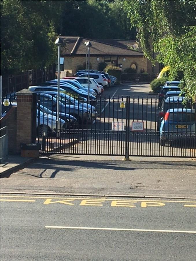
9 3 Parking Information 3.0 Farnborough Primary School - On-Site Parking Spaces Current On-Site Parking 19 Spaces The photographs in Section 8 provide evidence that the 18 parking spaces and the 7 new overflow spaces offered in the current application are all in daily use. The Transport Statement provided by the applicant indicates that there is a current peak parking demand of 15 cars, considerably less than the volume of cars already parking on-site on a daily basis. Planning Permission Rejected Planning Permission Deferred Plus Additional 5 spaces Plus Additional 5 spaces = Total 24 spaces = Total 29 spaces + 1 disabled bay which should not be used as a general parking bay Plus 1 disabled bay which should not be used as a general parking bay Additional number of parking spaces required. 7 overflow spaces NOT permissible The Applicant s Transport Statement contained a conservative estimate of a requirement to provide 12 additional parking spaces on top of the existing 18 spaces to meet peak demand for staff alone this seems to cover just teaching staff and a notional figure for classroom assistants. in contravention of LFEPA regulations - detailed in 3.2 & 3.3 NB These spaces are already in use throughout the school day None of the figures include parking for site staff, canteen staff or visitors. 7

10 3.1 Unitary Development Plan Appendix II Parking Standards Parking Design 11.4 The Plan states that parking areas should be designed as an integral element of the development itself, forming part of the setting adequate space should be made available for the provision of tree and shrub planting and screening materials which are desirable to achieve a high standard of design. The Planning Application considered on recommended the removal of all the planters in order to provide additional parking spaces. In order to achieve an increase in parking spaces the car park will no longer contain any tree and shrub planting or any screening materials. A tree was removed from the car park area a few years ago and has not been replaced by any other form of planting. If these items are removed to provide additional parking the car park will no longer achieve the desirable standard of design and will be contrary to the Local Authority s Unitary Development Plan, Parking Design Standards The removal of these desirable features is also contrary to the conditions placed on the original planning permission granted on landscaping in order to secure a visually satisfactory setting. 3.2 Overflow On-Site Parking Spaces in Contravention of the London Fire and Emergency Planning Authority s Requirements for Access for Fire Appliances The Application considered on added 7 additional overflow spaces intended to provide for any additional short term or peak parking demands during the day if needed. The overflow spaces are along the right hand side of the access road into the School opposite existing official parking spaces. These overflow spaces may compromise the safety of the School community by reducing the width of the only access road into the School to such an extent that it seems to be significantly in contravention of the London Fire and Emergency Planning Authority s requirements as stated in Fire Safety Guidance Note GN29 Access for Fire Appliances. In order to ensure compliance with regulations a total width for the access road incorporating all of the parking bays on the Planning Application is 11.1 m the actual width of the access road at the entrance gate is 10.2 m, a shortfall of almost a metre on the required width thereby significantly restricting access for a fire appliance. The 7 overflow spaces are all in use. The spaces have not been marked out. The blue car nearest the gates is clearly beyond the red bricked hardstanding area opposite which would indicate that it may not be possible to open the gates fully on the right hand side. 8

11 It is of great concern that the area identified in the plans for the new overflow spaces is currently already being occupied by cars parked throughout the whole school day even though spaces are not marked, have not been approved by the Planning Committee, may not meet LFEPA regulations and may compromise the safety of everyone on the School site. The Local Authority s Highway Engineer states: There are also 7 overflow spaces shown on the access road. However, these can only be used short term as they block in other spaces and may also preclude large vehicles getting onto the site. (Planning Application notes Section 2 Consultations) Pedestrian Footpath Bromley UDP II.6 Parking Dimensions Minimum Length of Parking Space (Horizontal) London Fire and Emergency Planning Authority Width Requirement For An Access Road Bromley UDP II.6 Parking Dimensions Minimum Width of Parking Space (Vertical) Total Minimum Width Required 5.0m 3.7m 2.4m 11.1 m Total Minimum Width Required by LFEPA GN25 Access for Fire Appliances is 11.1m Actual width of access road restricted by overflow parking is 10.2 m 9

12 3.3 Compromised Access for Fire Appliances The accessibility of the School to fire appliances is further compromised by parking at the far end of the school drive as the access road turns to the right. Cars have been recorded parking in the area as the access road turns the corner to the right possibly reducing the width of the access road to a level that is in contravention of GN25 Access for Fire Appliances. Cars parked in this location are also likely to further compromise access by blocking the turning and sweep circle which is required by a fire appliance in order to negotiate a corner, again in contravention of GN25 Access for Fire Appliances. LFEPA GN25 - Access for Fire Appliances Appendix 1 Turning and Sweep Circles 10
13 4 4.0 Traffic Information and Data School Travel Plan and Park and Stride Arrangements Section 2 of the Planning Application considered on Proposals Section reports that the Transport Statement states that Mitigation measures are identified which include the significant enhancement of the School Travel Plan and Park and Stride arrangements being proposed. NEEDS CHECKING This statement is somewhat confusing. The School Travel Plan and Park and Stride arrangements were put in place in 2013 and there has been no revision of these documents since that time. Revised documents have not been included with the planning application (IS THIS TRUE?) It can only be assumed that the significant enhancement occurred before The School s Travel Plan has silver status what is this (not the top?) Regarding Park and Stride Arrangements - the data supplied in the Transport Statement is for the school cohort from 3 school years ago and lacks relevance to the current application. If pupils park and stride it would seem logical that parking would still be within the confines of the Village thereby adding to the parking burden. It would seem highly unlikely that cars would park on the opposite side of the A21 with parents negotiating crossing this busy main road with young children at peak times. 4.1 Staff Modes of Transport The Transport Statement reports that there is an existing staff peak parking demand of 15 cars, this does not correlate with photographic evidence documenting a significantly higher number of cars parking on-site on a daily basis at both peak and off-peak times. The applicant s requirement for parking only seems to take into account teaching staff and a notional/pro-rata figure for classroom assistants. There does not appear to be any provision for site staff, canteen staff, midday supervisors or visitors to the site who would generate a significant on-street parking demand on a daily basis. The data in the Transport Statement relates to a cohort of staff from a period of 3 school years ago and the data is therefore significantly out of date. 11
14 4.2 Pupils Modes of Transport The Transport Statement contains a prediction on the future travel habits of pupils which is contrary to the evidence already highlighted by the significant extension to the catchment area. The catchment area has extended from a mean of approximately miles over the last 3 reported years ( ) to 1.43 miles for the September 2015 intake. The original mean 0.4 miles is broadly in line with many primary schools within the Local Authority s area. The School Travel Plan dated 2013 states that 2% of pupils currently car share with non-family members. The School have set a target of 4% of pupils sharing with non-family members. There is no evidence provided to indicate that this target has been met over the last 3 years. The School Travel Plan sets a target of 38% of pupils walking to school. In 2014 the numbers walking to school went down from 44% to 35%. In 2015 the numbers walking remained at 35%. There is no evidence provided that indicates the target has been met and the trend would appear to be a reduction in the numbers walking rather than an increase. 4.3 Parking Surveys The data provided in the Transport Statement is out-dated, reporting on a surveys carried out in March 2015 and the last week of July 2015 directly before the summer break. The Parking Surveys are therefore based on a school cohort from 3 school years ago, do not report on the current parking burden and pre-date the additional parking restrictions placed on the High Street in Pay and Display Parking The introduction of Pay and Display parking in the High Street in June 2016 has created a significant increase to the on-street parking burden on Farnborough Hill. Parked cars are continually present throughout the day in the section from the School extending down the Hill into the wooded section on the south side. This is creating a significant impact to the traffic flow throughout the day due to the narrow width of the road and identified problems with buses and lorries trying to pass. 4.5 Service Vehicles In order to access the School site delivery vehicles are required to reverse into the School access road as they are unable to turn within the School site. This has an inevitable impact on the traffic whilst these manoeuvers are taking place. Residents have also reported noisy deliveries at night with vehicles reversing in and their headlights shining directly into residential properties. 12
15 5 5.0 Proposed Mitigation Measures Overview of Proposed Mitigation Measures The Transport Statement provided by the School proposes 6 mitigation measures to address concerns regarding highways safety, traffic congestion, lack of on-site parking and the increase of on-street parking contrary to Policy T18 and BE1 of the Unitary Development Plan. All 6 proposals are non-viable and should be discounted as mitigation measures as follows: 5.1 Single Yellow Lines North Side of Farnborough Hill The Transport Statement offers the installation of single yellow lines on the North Side of Farnborough Hill to restrict daytime parking, particularly to allow cess pit emptying. The single yellow lines would extend from the bus stop into the downhill wooded section. This is a distance of approximately 115 meters. The section of the highway directly before this proposal is already restricted for a distance of approximately 65 meters from Tubbenden Lane South to the Bus Stop. This would give a total restriction on parking on the north Side of Farnborough Hill for a distance of 180 meters. This proposal would also prevent the cess pit tanker from parking outside the houses that require this service. 5.2 Single Yellow Lines South Side of Farnborough Hill The Transport Statement offers the installation of single yellow lines on the south side of Farnborough Hill to restrict daytime parking, particularly to allow adequate visibility for residents to exit their driveways and to provide adequate road width to maintain traffic flow when the cess pit tanker is present. The proposed restriction would be imposed from the School extending past the access lane to the allotments and into the downhill wooded section past the houses needing cess pit tanker access. This is a distance of approximately 180 meters. The combination of these two proposed mitigations is, in effect, for single yellow lines on both sides of Farnborough Hill extending from the School to approximately the alleyway leading to Oleander Close restricting parking for a distance of 180 meters on both sides. There are already parking restrictions in place in the opposite direction on the south side from the School to Church Road and on the north side from Tubbenden Lane South to Gladstone Road. The proposal would create a vast no parking zone around the School, unprecedented in a Village setting, it would push the parking burden further down Farnborough Hill. This would create a situation even more detrimental to highways safety as the road down the steep hill remains narrow and leads on to a notoriously dangerous mini roundabout at the end of Shire Lane where there are frequent serious accidents and sadly recently there have been fatalities. 13
16 The proposed mitigations for single yellow lines would place a totally unacceptable level of restriction to residential amenity. The no parking zone created on Farnborough Hill would prevent all services from parking anywhere near the properties they are trying to access. Services would include Doctors, District Nurses, Delivery vehicles, Home Care Assistants, postal services and visitors. In particular, it would prevent access for the cess pit tanker, an essential service, required by a number of houses on Farnborough Hill which do not have access to mains drainage. The Allotment holders would be denied the ability to park on Farnborough Hill in the vicinity of the allotments removing a substantial amenity to the community. The effectiveness of this type of proposal as a resolution to the problem caused by insufficient on-site parking has also been highlighted. The Highway s Engineer has commented that yellow lines around schools are difficult to enforce, unless an Enforcement Officer is present they are often ignored and their introduction is unlikely to have the desired effect to control the parking. Councillor Colin Smith, Deputy Leader of the Council and Portfolio Holder for Environment, has confirmed that it is not possible for the Local Authority to schedule Parking Enforcement Officers to patrol the roads surrounding Farnborough Primary School. The Deputy Leader reports that for the whole of the Borough there are only 30 Traffic Wardens with existing beats and roads to patrol. The Deputy Leader further reports that due to the parking reforms brought in by Eric Pickles, Minister of State for Local Government, the CCTV fleet has been disbanded as it was no longer able to fund itself. The evidence supplied indicates this proposal is clearly non-viable and should be discounted as a mitigation measure. 5.3 Signs in Chartwell Drive The Transport Statement suggests signs could be installed bearing the School s name asking parents not to park in Chartwell Drive. There is no indication of where the signs might be installed whether in the highway or on land owned by residents. Traffic signs for use on the highway must either be prescribed by the Traffic Signs Regulations and General Directions (TSRGD) as amended, or be specially authorised by the Secretary of State. Signs that are neither prescribed nor authorised are unlawful obstructions on the highway and are not permitted. Mike Hammond, Highway Development Engineer, LBB, has confirmed that there has been no formal request for the signs... and, Chartwell Drive is an adopted highway and the Council would not normally permit non-standard and unenforceable signs to be erected on the highway. Mr Hammond further reports There is a general policy against any unnecessary signs to reduce street clutter. 14

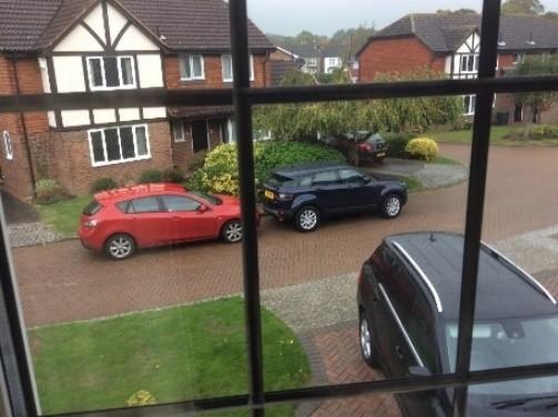
17 There are 18 residential properties in Chartwell Drive. The majority of the properties in the small narrow close were designed for the elderly and currently 12 of the 18 properties are occupied by elderly residents. In order to ascertain views on how this proposal would affect residential amenity, impact on the character of the local area and whether it would provide a realistic solution a survey has been conducted with 15 of the 18 property owners completing the survey. The residents expressed the following concerns: The signs would not be authorised and would merely be a request that has no legal standing and is un-enforceable. Un-enforceable signs would spoil residential amenity as they would form street clutter and be a visual intrusion. 12 of the 15 residents would not permit the signs to be installed on their property or land. The Transport Assessment - Part 1 March reported that the School have set out proposals and commitments to update and improve the School Travel Plan. In particular they have proposed to include commitments in the School Travel Plan with regard to parking and driving behaviour outside the School, and behaviour towards local residents. There will be a specific undertaking required of parents not to park in Chartwell Drive. The current situation in Chartwell Drive does not reflect the Transport Assessment s Report. The Residents of Chartwell Drive have reported feeling that they are under siege at peak school times and the request is clearly ignored on a daily basis as parking demand is already so high. Residents report that their driveways are regularly blocked by parked cars precluding them from being able to exit in their own cars. Chartwell Drive has no pavement so children are regularly off-loaded onto residents gardens. Unfortunately, reports have been received that mothers are standing in residents gardens drinking coffee and children have urinated in a residents garden. Elderly residents report being intimidated by drivers if they are walking along the road and not moving fast enough. Residents report being verbally abused. Highway safety is of great concern in this area. 15

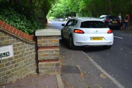
18 It should be noted that the land at the entrance to Chartwell Drive extending into the close for a considerable distance belongs to the properties on Farnborough Hill. Owners of the land have indicated that they would not permit signs to be installed on their property or land, therefore, signs would not be viable in this area. In conclusion neither the Local Authority s Highway Development Engineer nor the owners of the land would permit signs to be installed at the entrance to Chartwell Drive. The evidence supplied indicates this proposal is clearly non-viable and should be discounted as a mitigation measure. Entrance to Chartwell Drive restricted Pavement in Farnborough Hill partly blocked 5.4 Short Term Yellow Line Parking Restrictions in Chartwell Drive The proposal recommends short term yellow line parking restrictions be introduced in Chartwell Drive. The proposal does not contain any detail on the scale of the restrictions or the duration of the time they would be in place for. Chartwell Drive is a narrow close with no pavements. Many elderly residents receive daily visits from health care professionals, delivery vehicles, family and friends in addition to their own parking requirements. To introduce yellow lines into this small residential close would place an unacceptable level of restriction to residential amenity. The Residents Survey revealed the following concerns: Yellow lines would apply to everyone and would prevent access to homes by health care workers, doctors, meal deliveries, goods deliveries, repair services, visitors and even the residents themselves as they would be precluded from parking outside their own properties. Residents would require parking permits and should be provided with them free of charge. Yellow lines would spoil the residential amenity of the close. Regular parking enforcement would be required. The Highway s Engineer has commented that yellow lines around schools are difficult to enforce, unless an Enforcement Officer is present they are often ignored and their introduction is unlikely to have the desired effect to control the parking. 16
19 Councillor Colin Smith, Deputy Leader of the Council and Portfolio Holder for Environment has confirmed that it is not possible for the Local Authority to schedule Parking Enforcement Officers to patrol the roads surrounding Farnborough Primary School. The Deputy Leader reports that for the whole of the Borough there are only 30 Traffic Wardens with existing beats and roads to patrol. The Deputy Leader further reports that due to the parking reforms brought in by Eric Pickles, Minister of State for Local Government, the CCTV fleet has been disbanded as it was no longer able to fund itself. The evidence supplied indicates this proposal is clearly non-viable and should be discounted as a mitigation measure. 5.5 Permanent Raised Pedestrian Crossing Across Farnborough Hill The Highway s Engineer has confirmed that there is no justification for the introduction of a zebra crossing at this location, thereby confirming that this proposal is non-viable. A raised platform or Flat Top Speed Table is covered by the Highways (Road Humps) Regulations A proposal for a raised platform requires considerable consultation before it can be put forward as a viable option. Consultation must take place with the Police, Fire and Ambulance Services. As Farnborough Hill is on a bus route consultation must also take place with TFl and Arriva. The Transport Statement provides no evidence that any of these consultations have taken place. A raised platform should also be cited away from conflict points at uncontrolled junctions. Tubbenden Lane South is an uncontrolled junction just 20 meters away from the School it is a daily conflict point with drivers attempting U turns at the top of this narrow lane as it joins the High Street. A raised platform should be 6 meters wide with a maximum height of 75mm, with on/off gradients of 1:20. The platform should be installed in the desire line (the best place to cross from a pedestrian s point of view). There is insufficient room to install such a structure in the vicinity of the school without obstructing residents driveways or encroaching on the school entrance driveway. Transport for London stipulates that there must be no more than 5 raised top speed tables/raised pedestrian crossings on any one bus route. This directive is to protect the health of the bus drivers and limit wear and tear to the buses. There are already a significant number of these speed tables in the local area and the 358 route extends as far as Crystal Palace. If a speed top table were to be introduced in Farnborough Village, it would seem likely to impact the viability of the bus service through the Village according to TFL s own guidance. A raised top speed table in the vicinity of the school would also have implications for the main Village bus stop as it would be in very close proximity to the speed table which is likely to be problematic or non-viable. The Highway s Engineer has confirmed there is no justification for this crossing. The evidence supplied indicates this proposal is clearly non-viable and should be discounted as a mitigation measure. 17
20 5.6 Footway to Be Provided for The Southern Section of Tubbenden Lane South The Highway s Engineer has confirmed that there are no proposals to create a footway for Tubbenden Lane South. The Highway s Engineer further states that it is unlikely that the provision of a footway would have any impact on the number of vehicular trips associated with the school. The proposed footway would severely restrict the width of the road approaching the unmanned junction which is the access road for the High Street and Farnborough Hill for all the residents who live on the north-east side of the Village. The Transport Statement has not ascertained who owns the land where the proposed footway would be sited or how far it would extend along Tubbenden Lane South. There are no proposals to include parking restrictions, the absence of which would lead to the road width being further compromised. If parking restrictions were to be included this would reduce the amount of on-street parking available further exacerbating the current situation. The Highway s Engineer notes that no costings have been submitted with this proposal. The evidence supplied indicates this proposal is clearly non-viable and should be discounted as a mitigation measure. 5.7 Conclusion The detailed evidence in this Report clarifies that all 6 proposed mitigations are non-viable and do not address the reasons for refusal. The planning proposal remains: Detrimental to highways safety Detrimental to residential amenity by virtue of increased traffic congestion Fails to provide adequate on-site parking Increases levels of on-street parking contrary to Policy T18 and BE1 of the Unitary Development Plan. 18

21 6 Education Pupil Place Planning 6.0 Planning Area 5 The Local Authority s Primary and Secondary School Development Plan allocates Farnborough Primary School to Planning Area 5. The Planning Area covers the three wards of Bromley Common and Keston, Petts Wood and Knoll and Farnborough and Crofton. There are 10 primary Schools within this area: Crofton Infants, Crofton Junior, Darrick Wood Infants, Darrick Wood Juniors, Southborough, Tubbenden, Keston, Trinity, St James and Farnborough. Trinity Village Primary Farnborough Primary School Planning Area 5 is extensive and includes the new Trinity Village housing development on Bromley Common, within the Bromley Common and Keston Ward, consisting of 778 dwellings. It is reasonable to conclude that there would be a significant demand for school places generated by this housing development and these residents would welcome their children being able to access a local school within walking distance of their homes. Farnborough Village is situated 5 kilometres away from this new development and has approximately 840 dwellings with possibly no more than 3 new houses built in the last 10 years. No evidence has been provided to suggest that there is an absence of alternative sites in Planning Area 5. The Southborough Lane Campus and the Trinity site, both within Planning Area 5, could potentially provide additional places in more appropriate locations. 19
22 The population demographic and density in Planning Area 5 would indicate that more pupils are likely to live in the Bromley Common area nearer to the Trinity School site and Southborough Lane Campus than Farnborough reducing the need to travel by car which would be in line with the Interactive Unitary Development Plan (IUDP) Transport 5.12 where development has the potential to increase demand on roads and public transport resources but can be located and designed in a way that minimises impact and improves rather than degrades environmental amenity. Policy C1 of the Unitary Development Plan states that school places should be accessible by modes of transport other than the car and accessible to members of the community it is intended to serve. Policy C7 of the Unitary Development Plan requires educational establishments to be located so as to maximize access by means of transport other than the car. 6.1 LBB Education Portfolio Priorities Report Sept 2015-Aug 2016 FINAL Aim 2a of the Report identified the implementation of the Primary Schools Development Plan to provide additional reception places for September 2016 and beyond in the following Planning Areas : 1,2,4,6,7 and 8. Planning Area 5 was not identified for development to provide additional reception places in this Report. 6.2 Education Budget Sub-Committee Thursday 14 January 2016 In response to a question from a Member, the Portfolio Holder for Education confirmed that Officers were working to identify if the Southborough Lane campus currently used by the Bromley Youth Music Trust would be needed for the provision of additional school places in Planning Area 5 in future years. 6.3 LBB Education PDS Committee Statement of Executive Decision The proposed decision was scrutinised by the Education PDS Committee on 27 th January 2015 and the Committee supported the proposal. As follows: The Portfolio Holder for Education, has made the following executive decision: Primary & Secondary School Development Plan Planning Area 5 Wards, Bromley Common and Keston, Petts Wood and Knoll, Farnborough and Crofton: To keep school organisation and size in the area under review and to consider medium term options for enlargements. NB Other planning areas where the same conclusion was reached ie review and consider medium term options actually identified specific schools for consideration and how much they should be expanded by there was no such recommendation in Planning Area 5 for any school. 20
23 7 7.0 Additional Concerns Unacceptable Impact on the Conservation Area The centre of Farnborough Village is designated a Conservation Area and as such is covered by guidance about the way in which the area should be managed to preserve and enhance its character. The Guidance Statement (3.1) recognises that Farnborough still retains its village character and appearance and advises that the Council will ensure that new development pays heed to the small scale of its surroundings. Whilst the Primary School is just outside the boundaries of the Conservation Area the impact created by doubling the size of the School will have a significant impact on the main conservation objective ie to ensure the survival of the village character. The increase in traffic created by the development of the School will change the character of the Village. 7.1 Identified Harm to the Green Belt Farnborough Primary School is a Green Belt site and as such is a non-compliant site requiring demonstration of exceptional circumstances (including the absence of alternative sites) to justify green belt release. The information provided by the Local Authority under Section 2 - Applications meriting special considerations - regarding the Planning Application considered on 14 July 2016 clearly outlines that the proposed extension and temporary classroom buildings would be considered inappropriate development within the Green Belt as educational uses (Class D1) and would not fall within the appropriate uses defined by Policy G1 of the Unitary Development Plan or the NPPF. No evidence has been provided to suggest that there is an absence of alternative sites in Planning Area 5. The Southborough Lane Campus and the Trinity site, both within Planning Area 5, could potentially provide additional places in more appropriate locations. The population demographic and density in Planning Area 5 would indicate that more pupils are likely to live nearer to the Trinity School site and Southborough Lane Campus than Farnborough reducing the need to travel by car which would be in line with the Interactive Unitary Development Plan (IUDP) Transport 5.12 where development has the potential to increase demand on roads and public transport resources but can be located and designed in a way that minimises impact and improves rather than degrades environmental amenity. Policy C1 of the Unitary Development Plan states that school places should be accessible by modes of transport other than the car and accessible to members of the community it is intended to serve. Policy C7 of the Unitary Development Plan requires educational establishments to be located so as to maximize access by means of transport other than the car. 21
24 Bus Route There have been reports that Transport for London have confirmed that the 358 bus route through the Village will be maintained. The Borough Engagement Manager (South), Transport for London Planning ( ) has reported that the 358 bus route was recently tendered on a 7 year contract retained by Metrobus with new vehicles on this route. We typically undertake route reviews and subsequent changes to services at the point of retendering. In the case of the 358 no change to route or frequency was made. Whilst this does not limit us to making changes throughout the contract, we have no current intention to reroute buses from Farnborough Village. This statement is not a guarantee that the bus service through Farnborough Village will be maintained. It is merely a confirmation of the present arrangements. 7.3 Arcadian Arcadian is a residential dwelling located on the north-east boundary of the School site. There are a number of specific concerns regarding the impact of the proposed plans on this property. Phase Receptors Impact on Residents Health - Within the 20m Buffer Area The Phlorum Air Quality Assessment report, Figure 1: Construction Phase Receptors shows that Arcadian is within the 20m Buffer Area. Item 5.17 on page 21 states Within distances of 20m of the site boundary there is a high risk of dust impacts, regardless of the prevailing wind direction. Up to 100m from the construction site there may still be a high risk, particularly if the receptor is downwind of the dust source. The property owner has a diagnosed medical condition which is aggravated by dust. The property is clearly within the Buffer Area and therefore the planning proposals present a significant danger to the health of the residents. Site Layout Planning for Daylight and Sunlight The proposed development has not taken into consideration the site layout for daylight and sunlight. There is no impact statement on the effect the proposed development will have on Arcadian. From the size of the proposed plans it is obvious that available daylight and sunlight will be severely restricted to the garden, thereby reducing the amenity and enjoyment of the property. Overshadowing The proposed plan extends the existing building by adding a double storey. The closeness and scale of the proposed development will create significant overshadowing to Arcadian s garden. It will have a considerable impact on the light received, thus restricting the amenity and enjoyment of the garden. Furthermore, in assessing the proposed plan, it should be taken into account that Arcadian already has to suffer the effects of the 2010/11 expansion, when another section of the school building and play area was extended right up to Arcadian s fence. This has already caused overshadowing in the house and garden. 22

25 Overlooking The proposed plan significantly extends the existing footprint of the school building, and adds a second storey. This will overlook Arcadian s house and garden. Arcadian has many windows on this side of the house, including a large conservatory. Occupants of the new school building will have a clear line of sight into the garden and house. The residents at Arcadian will therefore endure a huge loss of privacy. Exit Line of Sight Compromised The amount of on-street parking on Farnborough Hill prevents a clear line of sight when trying to exit Arcadian s driveway, which increases concerns regarding highways safety. Unfortunately, there are an increasing number of incidents where school traffic is parking across the entrance to the driveway shared by Arcadian and Hillcrest. Vehicles are then left unattended, making it impossible for the residents to exit the driveway or for any vehicles to access the properties. Original Planning Approval Conditions The school was built on Green Belt land, on the edge of a Conservation area, surrounded by trees. To ensure the design was in keeping with the landscape, approval for a single storey only building was granted. The original planning approval conditions stipulated: A boundary enclosure should be erected and maintained to protect the privacy and amenities of local residents. Landscaping in order to secure a visually satisfactory setting. To ensure that as many trees as possible are preserved in the interests of amenity. The proposed plan goes entirely against the original aims and approval conditions. Addressing each of the conditions in order: 23

26 7.3 The proposed building is double storey, excessively large and overbearing, and totally out of character with its surroundings. The privacy and amenities of local residents will therefore not be protected. The proposed plan significantly extends the existing footprint of the school building, and adds a second storey. The original visually satisfactory setting will be significantly altered. Trees on the site have not been preserved. Over a period of years many trees have been felled. The School building was expanded in 2010/11, the Notification of Grant of Planning Permission set out that felled trees should be replaced. Trees were felled and not replaced. The residents of Arcadian have raised the issue with the School and the Planning Department, even citing individual felled cherry trees. Over the past few years trees have been felled close to the proposed extension site. If permission is granted more trees will be removed. The loss of amenity due to the removal of trees is considerable and contravenes the original planning consent conditions. Cess Pit Tanker Servicing Houses in Farnborough Hill Several houses on Farnborough Hill are not connected to the main drain and therefore require large gallon tankers to park outside the houses on to carry out the emptying process which can take in excess of an hour on each occasion. On-street parking throughout the day on the south side of Farnborough Hill is now substantial, particularly with the introduction in June 2016 of new parking restrictions in the High Street. The increased parking burden remaining in place for extended periods of the day has a significant impact on the traffic flow through the Village particularly when the tanker is present. The width of the road at the top of Farnborough Hill is not sufficient to accommodate the large cess pit tanker and parked cars and still allow the traffic to flow freely resulting in a chaotic situation where buses and cars and held back and cannot pass. On a couple of occasions, the tanker driver has been unable to park and has returned at another time the tanker company cannot possibly build a go away and try again later time into their schedule and with the increasing amount of daily parking on the Hill the tanker has recently had to park up and carry out the emptying regardless of the chaos that ensues as it is imperative that residents are able to access an essential mains service. On-Site Parking Including Overflow Spaces 24


27 25


28 Farnborough Hill Farnborough Hill 26


29 Farnborough Hill 27


30 Drive Chartwell 28


31 Tubbenden Lane South 29


32 High Street 30


33 Church Road 31


34 Palmerston Road 32
Regulatory Committee
 Page 1 - Proposed Turning Movement Bans at South Gate Junction, Dorchester Regulatory Committee Date of Meeting 16 March 2017 Officer Subject of Report Executive Summary Andrew Martin Service Director
Date: 11 th January, From: Plaistow & Ifold Parish Neighbourhood Plan - Steering Group. Plaistow & Ifold Parish Council
 Date: 11 th January, 2017 From: Plaistow & Ifold Parish Neighbourhood Plan - Steering Group To: Plaistow & Ifold Parish Council Re: Neighbourhood Plan Report to Parish Council Meeting 17 Jan 2017 The Steering
Seek the Board s approval for the Donald Place kerb and channel renewal to progress to final design, tender and construction; and
 3. DONALD PLACE - KERB AND CHANNEL RENEWAL General Manager responsible: General Manager City Environment Officer responsible: Transport and City Streets Manager Author: Michelle Flanagan, Streets Capital
20mph Speed Limit Zones
 Traffic Advisory Leaflet 7/91 May 1991 20mph Speed Limit Zones Summary This leaflet illustrates the main steps in the procedures for the implementation of 20mph zones. It provides brief details on: the
The decision on whether to take enforcement action falls outside the scope of delegated powers.
 5k 16/0031 Reg d: 19.01.2016 Expires: 15.03.201 6 Ward: Nei. 24.02.201 BVPI Full Number of 11/8 On Con. 6 Target Weeks on Target? Exp: Cttee Day: GE No LOCATION: PROPOSAL: TYPE: Phillips Court, 32 Goldsworth
Finchley and Golders Green Area Committee 27 April 2017
 Finchley and Golders Green Area Committee 27 April 2017 Title Report of Wards Status Urgent Key Enclosures Officer Contact Details Junction of Regents Park Road / Tillingbourne Gardens, N3 Commissioning
Perth and Kinross Council Development Control Committee 27 August 2008 Recommendation by Development Quality Manager
 Perth and Kinross Council Development Control Committee 27 August 2008 Recommendation by Development Quality Manager 5(7) 08/414 Erection of kennels and cattery at Baltree Farm, Hatchbank, Kinross, KY13
Old Limberlost Sports Club, Butlers Road, Handsworth Wood, Birmingham, B20 2NT
 Committee Date: 07/03/2013 Application Number: 2012/07986/PA Accepted: 29/11/2012 Application Type: Variation of Condition Target Date: 24/01/2013 Ward: Handsworth Wood Old Limberlost Sports Club, Butlers
Ian Saxon Assistant Executive Director, Environmental Services
 Report To: SPEAKERS PANEL (PLANNING) Date: 14 December 2016 Reporting Officer: Ian Saxon Assistant Executive Director, Environmental Services Subject: OBJECTIONS TO PROPOSED REMOVAL OF LEECH STREET / BACK
Sainsburys Store, Mere Green Road, Sutton Coldfield, Birmingham, B75 5BT
 Committee Date: 7/0/013 Application Number: 013/04/PA Accepted: 1/04/013 Application Type: Variation of Condition Target Date: 1/07/013 Ward: Sutton Four Oaks Sainsburys Store, Mere Green Road, Sutton
Derry Hill and Bingley Road, Menston. Accidents waiting to happen.
 Derry Hill and Bingley Road, Menston. Accidents waiting to happen. School Bus unable to pass on Hawksworth Drive References: Derry Hill - 10/04551/MAF Bingley Road - 10/06229/MAO Bingley Road - 11/05691/OUT
At a meeting of the Development Management Committee held on 22 February 2018
 1 HAVANT BOROUGH COUNCIL At a meeting of the held on Present Councillor Keast (Chairman) Councillors Buckley, Hughes, Keast, Perry, Satchwell, Lloyd and Guest (Standing Deputy) 105 Apologies for Absence
Bridge School, Longmoor Campus, Coppice View Road, Sutton Coldfield, Birmingham, B73 6UE
 Committee Date: 22/01/2015 Application Number: 2014/05949/PA Accepted: 08/12/2014 Application Type: Full Planning Target Date: 02/02/2015 Ward: Sutton Vesey Bridge School, Longmoor Campus, Coppice View
Environment Committee 24 September 2015
 Environment Committee 24 September 2015 Title Enforcement of Single Yellow Lines on Bank Holidays Report of Commissioning Director - Environment Wards All Status Public Urgent No Enclosures Key No Appendix
Ms J Delouche Sea View Cottage Cliff Road Margrave-on-Sea MUDHOLE ML20 7AX 15 October 2015
 Hazy Beacon District Council Chief Executive s Department Town Hall St Nicholas Street Mudhole ML16 3BY Ms J Delouche Sea View Cottage Cliff Road Margrave-on-Sea MUDHOLE ML20 7AX 15 October 2015 Dear Mr
Reference: 06/13/0594/F Parish: Fritton & St Olaves Officer: Mrs M Pieterman Expiry Date:
 Schedule of Planning Applications Committee Date: 21 st January 2014 Reference: 06/13/0594/F Parish: Fritton & St Olaves Officer: Mrs M Pieterman Expiry Date: 20-01-2014 Applicant: Proposal: Site: Lord
Commissioning Director - Environment
 Finchley and Golders Green Area Committee 27 April 2017 Title Report of Wards Status Urgent Key Enclosures Summers Lane,N12 Request for Pedestrian Improvements Commissioning Director - Environment Woodhouse
Planning Committee. Thursday, 26 May 2016
 Planning Committee Thursday, 26 May 2016 Attendees: Substitutes: Councillor Lyn Barton (Member), Councillor Helen Chuah (Member), Councillor Theresa Higgins (Chairman), Councillor Brian Jarvis (Member),
Speed control humps - Scotland, England and Wales
 Traffic Advisory Leaflet 3/91 September 1991 Speed control humps - Scotland, England and Wales Introduction Road humps are an extremely effective means of keeping vehicle speeds low. The standard round
London Borough of Barnet Traffic & Development Design Team
 London Borough of Barnet Traffic & Development Design Team AERODROME ROAD PEDESTRIAN FACILITY AND BUS STOP INTRODUCTION FEASIBILITY REPORT Job Number: 60668 Doc Ref: S106/12-13/60668 Author: Manoj Kalair
GUIDELINES FOR THE ADMINISTRATION OF SANCTIONS AGAINST SLOT MISUSE IN IRELAND
 GUIDELINES FOR THE ADMINISTRATION OF SANCTIONS AGAINST SLOT MISUSE IN IRELAND October 2017 Version 2 1. BACKGROUND 1.1 Article 14.5 of Council Regulation (EEC) No 95/93, as amended by Regulation (EC) No
Report on the Crafthole Traffic Light Project 3 rd July th September 2017
 Report on the Crafthole Traffic Light Project 3 rd July 2017 4 th September 2017 Brief History The village of Crafthole sits on the B3247 road, one of the 2 Gateways to the Rame Peninsula, the other being
Date 24/10/2011. Date 04/11/2011. Date 25/10/2011. Date 10/11/2011. Date 25/10/2011. Date 25/10/2011. Date 10/11/2011.
 DELEGATED POWERS REPORT NO. 1489 SUBJECT: Traffic Signal Review, Junction of Oakleigh Road North and the A1000 Control sheet All of the following actions MUST be completed at each stage of the process
Cabinet. The Future of Wareham Foot Level Crossing. Date of Meeting 24 February 2016
 Page 1 The Future of Wareham Foot Level Crossing Cabinet Date of Meeting 24 February 2016 Cabinet Member(s) Peter Finney Cabinet Member for Environment Colin Jamieson - Cabinet Member for Economy and Growth
Movement Strategy. November On behalf of Barton Oxford LLP
 Movement Strategy November 2014 On behalf of Barton Oxford LLP BARTON PARK, OXFORD. Movement Strategy 17/11/2014 Quality Management Issue/revision Issue 1 Revision 1 Revision 2 Revision 3 Remarks Date
ROAD TRAFFIC (PEDESTRIAN CROSSINGS) (JERSEY) ORDER 1982
 (JERSEY) ORDER 1982") ROAD TRAFFIC (PEDESTRIAN CROSSINGS) (JERSEY) ORDER 1982 Revised Edition Showing the law as at 1 January 2016 This is a revised edition of the law Road Traffic (Pedestrian Crossings) (Jersey) Order 1982
ROAD TRAFFIC (PEDESTRIAN CROSSINGS) (JERSEY) ORDER 1982 Revised Edition Showing the law as at 1 January 2016 This is a revised edition of the law Road Traffic (Pedestrian Crossings) (Jersey) Order 1982
Questions inviting views and conclusions in respect of the three short-listed options
 Questions inviting views and conclusions in respect of the three short-listed options Q1: What conclusions, if any, do you draw in respect of the three short-listed options? In answering this question
Open Report on behalf of Richard Wills, Executive Director for Environment & Economy. Nettleham Village Centre - Proposed Parking Restrictions
 Agenda Item 4.3 Regulatory and Other Committee Open Report on behalf of Richard Wills, Executive Director for Environment & Economy Report to: Planning & Regulation Committee Date: 16 February 2015 Subject:
North York Moors National Park Authority. Director of Planning s Recommendation
 21 July 2011 List Number 11 Scarborough Borough Council (North) Parish: Hinderwell App Num. NYM/2011/0255/FL Proposal: Location: Applicant: Installation of replacement upvc windows and doors to create
2.2 For these reasons the provision of tourist signing will only be considered:
 TOURIST SIGNING POLICY 2015 1. DEFINITION 1.1 A tourist destination is defined as a permanently established attraction which attracts or is used by visitors to an area and is open to the public without
Old Limberlost Sports Club, Butlers Road, Handsworth Wood, Birmingham, B20 2NT,
 Committee Date: 29/05/2014 Application Number: 2014/01237/PA Accepted: 20/02/2014 Application Type: Full Planning Target Date: 17/04/2014 Ward: Handsworth Wood Old Limberlost Sports Club, Butlers Road,
Hazardous Cattle Crossing: Use of Flashing Amber Lamps
 THE HIGHWAYS AGENCY THE SCOTTISH OFFICE DEVELOPMENT DEPARTMENT THE WELSH OFFICE Y SWYDDFA GYMREIG THE DEPARTMENT OF THE ENVIRONMENT FOR NORTHERN IRELAND Hazardous Cattle Crossing: Use of Flashing Amber
Gold Coast. Rapid Transit. Chapter twelve Social impact. Chapter content
 Gold Coast Rapid Transit Chapter twelve Social impact Chapter content Social impact assessment process...235 Existing community profile...237 Consultation...238 Social impacts and mitigation strategies...239
Consideration will be given to other methods of compliance which may be presented to the Authority.
 Advisory Circular AC 139-10 Revision 1 Control of Obstacles 27 April 2007 General Civil Aviation Authority advisory circulars (AC) contain information about standards, practices and procedures that the
Perth and Kinross Council Development Control Committee 12 December 2012 Report of Handling by Development Quality Manager
 Perth and Kinross Council Development Control Committee 12 December 2012 Report of Handling by Development Quality Manager 4(3)(i) 12/570 Alterations and replacement windows at Milnathort Town Hall, 1
Chapter 4 Route Window NE3 Manor Park station. Transport for London
 Chapter 4 Route Window NE3 Manor Park station MANOR PARK STATION 4 Route Window NE3 Manor Park station 4.7 Highway access to Manor Park station is very good. A117 Station Road connects with A116 to the
Boxley Parish Council Highway Issues Briefing Note M2 junction 3 A229 Local Traffic Infrastructure
 Boxley Parish Council www.boxleyparishcouncil.org.uk Chairman: Bob Hinder Clerk: Pauline Bowdery Assistant Clerk: Melanie Fooks 28 November 2017 Boxley Parish Council Highway Issues Briefing Note M2 junction
Response to the London Heathrow Airport Expansion Public Consultation
 Response to the London Heathrow Airport Expansion Public Consultation Summary This report sets out the response to the Heathrow Airport s consultation on airport expansion and airspace change. The consultation
Proposal for gypsy and traveller accommodation on land at Lower Hollow Copse (Pot Common), Copthorne. Statement of Community Involvement
, Copthorne. Statement of Community Involvement") Proposal for gypsy and traveller accommodation on land at Lower Hollow Copse (Pot Common), Copthorne Statement of Community Involvement Prepared by WYG Environment Planning Transport Ltd on behalf of the
Proposal for gypsy and traveller accommodation on land at Lower Hollow Copse (Pot Common), Copthorne Statement of Community Involvement Prepared by WYG Environment Planning Transport Ltd on behalf of the
TOWN TRUST. Bury St Edmunds Railway Station
 BURY ST EDMUNDS TOWN TRUST conserving buildings of historic interest The future of Bury St Edmunds Railway Station Part I Report October 2015 1 The future of Bury St Edmunds Railway Station NOTE: This
Perth and Kinross Council Development Management Committee 20 February 2013 Report of Handling by Development Quality Manager
 Perth and Kinross Council Development Management Committee 20 February 2013 Report of Handling by Development Quality Manager 4(4)(ii) 13/80 Replacement and re-positioning of street furniture, The Birks,
Minutes of the Planning Committee meeting of Chidham & Hambrook Parish Council held at Chidham Village Hall on 19 th September 2017 at 7.00 p.m.
 Minutes of the Planning Committee meeting of Chidham & Hambrook Parish Council held at Chidham Village Hall on 19 th September 2017 at 7.00 p.m. Present: Cllr Andy Collins (Chairman) Cllr Ina Littlefield
Regulating Air Transport: Department for Transport consultation on proposals to update the regulatory framework for aviation
 Regulating Air Transport: Department for Transport consultation on proposals to update the regulatory framework for aviation Response from the Aviation Environment Federation 18.3.10 The Aviation Environment
AAIB Safety Study - 1/2016
 Farnborough House Berkshire Copse Road Aldershot, Hants GU11 2HH Tel: 01252 510300 Fax: 01252 376999 www.aaib.gov.uk AAIB Air Accidents Investigation Branch AAIB Safety Study - 1/2016 AIRWORTHINESS OF
THE LONDON BOROUGH OF HOUNSLOW (HOUNSLOW HIGH STREET QUARTER) COMPULSORY PURCHASE ORDER 2015 THE LONDON BOROUGH OF HOUNSLOW
 COMPULSORY PURCHASE ORDER 2015 THE LONDON BOROUGH OF HOUNSLOW") THE LONDON BOROUGH OF HOUNSLOW (HOUNSLOW HIGH STREET QUARTER) COMPULSORY PURCHASE ORDER 201 THE LONDON BOROUGH OF HOUNSLOW RESPONSE TO WRITTEN REPRESENTATIONS BY LEGAL AND GENERAL ASSURANCE SOCIETY LIMITED
THE LONDON BOROUGH OF HOUNSLOW (HOUNSLOW HIGH STREET QUARTER) COMPULSORY PURCHASE ORDER 201 THE LONDON BOROUGH OF HOUNSLOW RESPONSE TO WRITTEN REPRESENTATIONS BY LEGAL AND GENERAL ASSURANCE SOCIETY LIMITED
Cuadrilla Elswick Ltd
 Cuadrilla Elswick Ltd Tewmporary Shale Gas Exploration Description Roseacre Wood, Lancashire Planning Inspectorate Reference APP/Q2371/W/15/3134385 Local Authority Reference: LCC/2014/0101 CE 1/3 Summary
an Inspector appointed by the Secretary of State for Communities and Local Government
 Appeal Decision Inquiry held on 24 May 2016 by Jonathan Bore MRTPI an Inspector appointed by the Secretary of State for Communities and Local Government Decision date: 27 June 2016 Appeal Ref: APP/Y3940/A/14/2223354
Queen s Circus Roundabout
 Stage 2 Road Safety Audit Ref: 1128-RSA-01 Prepared for: Steer Davies Gleave By: Capital Traffic Prepared by: Checked by: Approved by: Andy Haunton, Audit Team Leader Jonathan Thompson, Audit Team Member
Conservation Area Consent for demolition of existing building
 Committee Date: 19/09/2013 Application Number: 2013/02378/PA Accepted: 03/05/2013 Application Type: Conservation Area Target Date: 28/06/2013 Consent Ward: Ladywood 34 Carver Street, Jewellery Quarter,
PERTH AND KINROSS LOCAL REVIEW BODY
 PERTH AND KINROSS Minute of Meeting of the Perth and Kinross Local Review Body held in the Hay Room, Dewar s Centre, Glover Street, Perth on Tuesday 23 August 2016 at 10.45am. Present: Councillors M Lyle,
ACORNS PROJECTS LIMITED
 ACORNS PROJECTS LIMITED A4 London Road, M4 J5 to Sutton Lane, Slough, Berkshire Combined Stage 1 and 2 Road Safety Audit For Slough Borough Council Prepared by Acorns Projects Limited Safety Traffic Project
RUSTINGTON PARISH COUNCIL PLANNING COMMITTEE
 MINUTES: of the Meeting held on 26 June 2017 RUSTINGTON PARISH COUNCIL PLANNING COMMITTEE PRESENT: Councillors R Grevett (Chairman), J Bennett, Mrs A Cooper, T Field, A Jones, J Street and P Warren 58/17
Perth and Kinross Council Development Management Committee 27 March 2013 Report of Handling by Development Quality Manager
 Perth and Kinross Council Development Management Committee 27 March 2013 Report of Handling by Development Quality Manager 4(3)(ii) 13/138 Erection of a Structure for Floral Display in the Public Park,
Pre-application submission for Committee: Phase 4 development at West Hendon
 Pre-application submission for Committee: Phase 4 development at West Hendon 1. Development Details Phase 4 of the West Hendon Estate Regeneration. 2. Background The redevelopment of the West Hendon Estate
Strategic Director for Environment. Underhill and High Barnet. Summary
 Chipping Barnet Area Committee 19 February 2018 Title Report of Wards Status Enclosures Officer Contact Details Review of the Barnet Hospital Area Statutory Parking Consultation Strategic Director for
WESTHAM PARISH COUNCIL. DRAFT MINUTES OF THE FULL COUNCIL MEETING OF 19 th June 2017 held at The Amenity Hall, Stone Cross
 WESTHAM PARISH COUNCIL DRAFT MINUTES OF THE FULL COUNCIL MEETING OF 19 th June 2017 held at The Amenity Hall, Stone Cross 30 Present Councillors K Stevens, G Garner, K Saxby, N Beaney, A Lovell, J Blaker,
an Inspector appointed by the Secretary of State for Communities and Local Government
 Appeal Decision Hearing held on 6 October 03 Site visit made on 6 October 03 by B Hellier BA(Hons) MRTPI an Inspector appointed by the Secretary of State for Communities and Local Government Decision date:
Report of the Strategic Director, Regeneration to the meeting of Bradford South Area Committee to be held on 28 January U
 Report of the Strategic Director, Regeneration to the meeting of Bradford South Area Committee to be held on 28 January 2016. U Subject: WINDERMERE ROAD & SURROUNDING STREETS - PETITION Summary statement:
Trigger Point Justification Note 30 th August 2013
 1. Introduction Trigger Point Justification Note 30 th August 2013 DCC constructed a highway assignment model of Tiverton and the surrounding area and this suggested that in pure capacity terms, up to
Energy from Waste and Recycling Facility Trident Park, Cardiff. Planning History. January 2010 SLR Ref: B
 Energy from Waste and Recycling Facility Trident Park, Cardiff Planning History January 2010 Ref: 402-0036-0306B Viridor Ltd. i 402/0036/00306B CONTENTS 1.0 INTRODUCTION... 1 2.0 GENERAL HISTORY... 3
Wokingham Borough Council Response to the Consultation on the Draft Airports National Policy Statement
 Wokingham Borough Council Response to the Consultation on the Draft Airports National Policy Statement The consultation Draft Airports National Policy Statement (Draft NPS) sets out Government s policy
DEVELOPMENT MANAGEMENT COMMITTEE. 23 August 2011
 DEVELOPMENT MANAGEMENT COMMITTEE Agenda item 15 23 August 2011 APPLICATION NUMBER : CA//11/00883/VAR PROPOSAL : Variation of conditions 02 (drawings numbers); alterations in respect of internal layout
HEATHROW AIRSPACE AND FUTURE OPERATIONS CONSULTATION
 HEATHROW AIRSPACE AND FUTURE OPERATIONS CONSULTATION 1a. Do you support our proposals for a noise objective? Yes/ No/ I don t know No. 1b. Please provide any comments you have on our proposals for a noise
APPENDIX 1 Background to the Bower Ashton Residents' Parking Scheme proposals The RPS proposals meet the objectives of the Council's overall transport
 APPENDIX 1 Background to the Bower Ashton Residents' Parking Scheme proposals The RPS proposals meet the objectives of the Council's overall transport strategy as set out in the Joint Local Transport Plan
The following resource management issues have been identified as significant in the Art Deco Quarter:
 Chapter 59 ART DECO QUARTER SIGNS INTRODUCTION The Art Deco Quarter is Napier City s foremost shopping precinct as well as being the most important public place and pedestrian area. As such there are many
THRESHOLD GUIDELINES FOR AVALANCHE SAFETY MEASURES
 BRITISH COLUMBIA MINISTRY OF TRANSPORTATION & INFRASTRUCTURE AVALANCHE & WEATHER PROGRAMS THRESHOLD GUIDELINES FOR AVALANCHE SAFETY MEASURES British Columbia Ministry of Transportation & Infrastructure
Proposed Housing Developments In Great Horkesley
 Proposed Housing Developments In Great Horkesley Introduction Colchester Borough Council is producing a plan the purpose of which is to guide development in the Borough through to the year 2033. The Local
Whiteley Town Council
 Whiteley Town Council Town Clerk Nicki Oliver BSc (Hons), Heatherdene,Turkey Island, Shedfield, Southampton SO32 2JE Tel 01329 835019 email townclerk@whiteleytowncouncil.co.uk Mr Steve Tilbury Director
Nelson Mandela Community School, Colville Road, Sparkbrook, Birmingham, B12 8EH. Erection of single storey detached learning pod building
 Committee Date: 7/07/204 Application Number: 204/0362/PA Accepted: 22/05/204 Application Type: Full Planning Target Date: 7/07/204 Ward: Sparkbrook Nelson Mandela Community School, Colville Road, Sparkbrook,
NATMAC INFORMATIVE INTRODUCTION OF STANSTED TRANSPONDER MANDATORY ZONE (TMZ)
") Directorate of Airspace Policy NATMAC Representatives DAP/STNTMZ 23 July 2009 NATMAC INFORMATIVE Dear Colleagues INTRODUCTION OF STANSTED TRANSPONDER MANDATORY ZONE (TMZ) INTRODUCTION 1.1 NATS issued a
Directorate of Airspace Policy NATMAC Representatives DAP/STNTMZ 23 July 2009 NATMAC INFORMATIVE Dear Colleagues INTRODUCTION OF STANSTED TRANSPONDER MANDATORY ZONE (TMZ) INTRODUCTION 1.1 NATS issued a
North West London Hospitals NHS Trust
 North West London Hospitals NHS Trust Policy Communication Cover Sheet Policy Name: Post Holder Responsible: Approved by: Replaces: PARKING POLICY Philip Sutcliffe, Director of Corporate Services Executive
TfL Planning. 1. Question 1
 TfL Planning TfL response to questions from Zac Goldsmith MP, Chair of the All Party Parliamentary Group on Heathrow and the Wider Economy Heathrow airport expansion proposal - surface access February
John Betts School Crossing Review
 John Betts School Crossing Review Paddenswick Road London Borough of Hammersmith & Fulham August 2015 DOCUMENT CONTROL Project Centre has prepared this report in accordance with the instructions from the
Perth and Kinross Council Development Management Committee 30 August 2017 Report of Handling by Interim Head of Planning
 Perth and Kinross Council Development Management Committee 30 August 2017 Report of Handling by Interim Head of Planning 5(2)(ii) 17/270 Siting of 12 caravans/chalets, 3 show caravans/chalets and associated
Capital & Counties. October 2007
 Capital & Counties October 2007 Contents!" # $ % % $ & ' "&( # Appendix 1 Appendix 2 1 Introduction 1.1.1 Wincheap regeneration scheme proposes a 600 space Park and Ride facility to replace the existing
BOARHUNT PARISH COUNCIL MEETING - Minutes of 6 th July 2016
 Present Other Apologies Cllr E. Schofield (Chair) Clerk G. Wright Cllr C. Crowe Cllr C. Norwood WCC Cllr N. Cutler (from 7.40pm) Cllr C. Harmsworth Cllr B. Dell HCC Cllr P. Stallard Cllr J. Parker One
OBJECTION TO AMENDMENT TO PLANNING SCHEME AND GRANTING OF PLANNING PERMIT
 PLANNING AND ENVIRONMENT ACT 1987 OBJECTION TO AMENDMENT TO PLANNING SCHEME AND GRANTING OF PLANNING PERMIT AMENDMENT C32 APPLICATION 0873/02 Public Transport Users Association Inc. 247-249 Flinders Lane
DC/18/ Demolition of existing public house with bed & breakfast at the Forresters Arms 53 Perry Vale SE23 2NE
 DC/18/109536 Demolition of existing public house with bed & breakfast at the Forresters Arms 53 Perry Vale SE23 2NE While we have no objection to the principle of a hotel, in addition to a pub, operating
HEAD OF ECONOMIC PROMOTION AND PLANNING Nathan Spilsted, Senior Planning Officer Tel:
 7. TRAVELLER SITES ALLOCATIONS DOCUMENT REPORT OF: Contact Officer: Wards Affected: Key Decision: Report to: HEAD OF ECONOMIC PROMOTION AND PLANNING Nathan Spilsted, Senior Planning Officer Email: nathan.spilsted@midsussex.gov.uk
TRANSPORT FOR GREATER MANCHESTER COMMITTEE REPORT FOR RESOLUTION
 TRANSPORT FOR GREATER MANCHESTER COMMITTEE REPORT FOR RESOLUTION DATE: 11 November 2011 SUBJECT: REPORT OF: Proposed making of a Quality Partnership Scheme for the A6 corridor between Manchester and Hazel
REGULATION No. 990/2017 on the operation of remotely piloted aircraft CHAPTER I. General provisions Article 1 Objective
 REGULATION No. 990/2017 on the operation of remotely piloted aircraft CHAPTER I General provisions Article 1 Objective This Regulation sets out rules on the operation of remotely piloted aircraft with
Pembrey Country Park Caravan & Campsite 2018 Booking Conditions
 Pembrey Country Park Caravan & Campsite 2018 Booking Conditions Bookings Information:- Pembrey Country Park Pembrey, Llanelli, Carmarthenshire SA16 0EJ. Telephone: 01554 742424. E-mail: camppembrey@carmarthenshire.gov.uk
Arrangements for the delivery of minor highway maintenance services by Town and Parish Councils
 Arrangements for the delivery of minor highway maintenance services by Town and Parish Councils Cabinet Date of Meeting 8 March 2017 Officer Cllr Peter Finney, Cabinet Member for Environment, Infrastructure
APPLICATION No. D/2016/476. Members of 2011 Residents Association object to this proposal and provide the following reasons for our objection:
 8 June 2016 APPLICATION No. D/2016/476 118A DARLINGHURST ROAD, DARLINGHURST NSW 2010 Members of 2011 Residents Association object to this proposal and provide the following reasons for our objection: Background:
REAUTHORISATION OF THE ALLIANCE BETWEEN AIR NEW ZEALAND AND CATHAY PACIFIC
 Chair Cabinet Economic Growth and Infrastructure Committee Office of the Minister of Transport REAUTHORISATION OF THE ALLIANCE BETWEEN AIR NEW ZEALAND AND CATHAY PACIFIC Proposal 1. I propose that the
LHNCC 144/9 Commercial Street Edinburgh EH6 6LB. Mob: March 2018
 LHNCC 144/9 Commercial Street Edinburgh EH6 6LB Mob: 07810735518 e-mail: secretary@lhncc.org.uk 28 March 2018 David Leslie Head of Planning and Transport, PLACE, Waverley Court, 4 East Market Street, Edinburgh,
Centurion Way Chichester
 Centurion Way Chichester Work book of plans to show details of the Centurion Way, its links, and potential developments and enhancements from linking to the South Downs National Park all the way to the
12, 14 and 16 York Street - Amendments to Section 16 Agreement and Road Closure Authorization
 REPORT FOR ACTION 12, 14 and 16 York Street - Amendments to Section 16 Agreement and Road Closure Authorization Date: April 27, 2018 To: Toronto and East York Community Council From: Senior Strategic Director,
WORKING TOGETHER TO ENHANCE AIRPORT OPERATIONAL SAFETY. Ermenando Silva APEX, in Safety Manager ACI, World
 WORKING TOGETHER TO ENHANCE AIRPORT OPERATIONAL SAFETY Ermenando Silva APEX, in Safety Manager ACI, World Aerodrome Manual The aim and objectives of the aerodrome manual and how it is to be used by operating
MINUTES OF MEETING OF ASSINGTON PARISH COUNCIL Held in Assington Village Hall on Monday 30 th July 2018
 Present: Attending: Councillors Simon Thorogood (Chairman), Stephen King, Steve Betts, Rose Symonds, Bronwen Stacey and Helen Wallace District Councillor Jennie Jenkins, Arthur Charvonia, John Ward and
SUTTON UNDER WHITESTONECLIFFE PARISH COUNCIL
 SUTTON UNDER WHITESTONECLIFFE PARISH COUNCIL A170 Sutton Bank Application for a Permanent Traffic Regulation Order (TRO) for Prohibition of HGVs The purpose of this document is to support a request from
Submission on the Tukituki Catchment Proposal: EPA reference numbers; NSP 13/ , NSP 13/ , NSP 13/ , NSP 13/02.
 Hutt Valley Tramping Club PO Box 30 883 LOWER HUTT 5045 Tukituki Catchment Proposal Environmental Protection Agency Private Bag 63 002 WELLINGTON 6140 29 July 2013 Submission on the Tukituki Catchment
Member Benefits Special Offer
 Member Benefits Special Offer First Name (as listed in Velocity profile) Last Name (as listed in Velocity profile) Contact Number Velocity Number (If you do not hold a membership to Velocity Rewards, please
Chapter 6 Route Window NE5 Seven Kings station. Transport for London
 Chapter 6 Route Window NE5 Seven Kings station Transport SEVEN KINGS STATION 6 Route Window NE5 Seven Kings Station Transport Introduction 6.1 All construction activities in this route window are associated
7. CONSULTATION ON THE TRAVELLER SITES ALLOCATIONS DOCUMENT
 7. CONSULTATION ON THE TRAVELLER SITES ALLOCATIONS DOCUMENT REPORT OF: HEAD OF ECONOMIC PROMOTION AND PLANNING Contact Officer: Nathan Spilsted, Senior Planning Officer Email: nathan.splistead@midsussex.gov.uk
SCHOOL CROSSING PATROL POLICY
 Appendix A SCHOOL CROSSING PATROL POLICY March 2003 Page 39 SCHOOL CROSSING PATROLS IN LINCOLNSHIRE POLICY DOCUMENT INTRODUCTION 1.1 The aim of this policy is to provide an efficient and effective school
THE PROPOSED NETWORK RAIL (ESSEX AND OTHERS LEVEL CROSSING REDUCTION) ORDER DEPARTMENT FOR TRANSPORT REFERENCE: TWA/17/APP/05
 ORDER DEPARTMENT FOR TRANSPORT REFERENCE: TWA/17/APP/05") OBJ/148/ W 031 E20 SNIVELLERS THE PROPOSED NETWORK RAIL (ESSEX AND OTHERS LEVEL CROSSING REDUCTION) ORDER PUBLIC INQUIRY, 18 OCTOBER 2017 DEPARTMENT FOR TRANSPORT REFERENCE: TWA/17/APP/05 OBJECTION BY
OBJ/148/ W 031 E20 SNIVELLERS THE PROPOSED NETWORK RAIL (ESSEX AND OTHERS LEVEL CROSSING REDUCTION) ORDER PUBLIC INQUIRY, 18 OCTOBER 2017 DEPARTMENT FOR TRANSPORT REFERENCE: TWA/17/APP/05 OBJECTION BY
Control of Cranes and Other Temporary Obstacles
 United Kingdom Overseas Territories Aviation Circular OTAC 139-27 140-11 171-8 172-11 178-10 Control of Cranes and Other Temporary Obstacles Issue 1 1 June 2018 Effective on issue GENERAL Overseas Territories
Display of 1 no. internally illuminated advertisement hoarding
 Committee Date: 22/08/2013 Application Number: 2013/04695/PA Accepted: 01/07/2013 Application Type: Advertisement Target Date: 26/08/2013 Ward: Ladywood Summer Row, Birmingham, B3 1JU Display of 1 no.
PERTH-ADELAIDE CORRIDOR STRATEGY
 INTRODUCTION The Royal Automobile Association of SA Inc (RAA), the State s principal advocate for motorists on a broad range of motoring-related issues, represents the views of more than 560,000 South