REQUEST FOR COUNCIL ACTION
|
|
|
- Natalie Erika Heath
- 5 years ago
- Views:
Transcription

1 REQUEST FOR COUNCIL ACTION Date: Item No.: 14.e Department Approval City Manager Approval Item Description: Roseville Deer Management BACKGROUND The City of Roseville, in conjunction with Ramsey County, has been completing aerial surveys of the deer population since The aerial surveys consist of a helicopter fly over after a fresh snowfall counting the number of deer seen. In addition to the deer tracking the Roseville Police Department, MN Highway Patrol and Roseville Public Works also track the number of cars hit by deer and carcass removal requests. Below are the results of the deer tracking in Roseville since 2004: Based on the amount of habitat in Roseville it was determined by the Minnesota Department of Natural Resouces (MNDNR) that our city can support a population of deer. Page 1 of 3
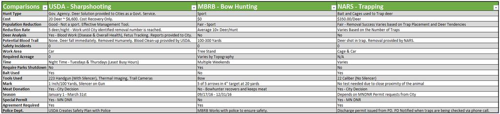
2 In 2014, deer population concerns were raised, specifically in the Owasso area. The complaints have primarily been regarding: Damage to gardens and vegetation in resident s yards Tameness of deer Health concerns In response to the growing concerns, Roseville adopted a Wildlife Management Ordinance in The ordinance included a feeding ban on wild animals typically found in Roseville. The feeding ban prohibits: Distributing one or more gallons of grains, vegetables, fruits, nuts, or hay within a 24-hour period is prohibited Having a salt lick at a location that regularly attracts wild animals is prohibited o Note: The ordinance includes an exemption for small backyard bird feeders Penalties for violating the feeding ban are a series of administrative fines, including $100 for the first violation, $200 for a second and $300 for subsequent violations within a two-year period. The Roseville Community Development Code Enforcement Officer enforces the feeding ban. Since the ordinance was enacted there have been six official complaints reported and followed up on. The ordinance also allows for organized hunts to control the city's deer population, should the City Council determine a need based on deer population counts. At the time the ordinance was adopted the Parks and Recreation Commission suggested to monitor the deer population for 2 years to understand the feeding ban s impact. However, there still appears to be community concern for the large numbers of deer in Roseville. To help better understand potential control options, Parks and Recreation Staff worked with representatives from the; MNDNR, Ramsey County, Department of Agriculture (USDA) the Metro Bow Hunters Resource Base (MBRB) and Nuisance Animal Removal Service (NARS). Based on the research the available options for deer control include: 1. Sharp Shooting Specially-trained deer sharp shooters from the United States Department of Agriculture (USDA) are hired to come into a community with the purpose of removing a large amount of deer at one time. They are trained to shoot as efficiently and effectively as possible to minimize the possibility of the herd scattering, and to quickly dispatch deer and maintain safety to surrounding residents. 2. Bow Hunting Through the Metro Bow Hunters Resource Base (MBRB) individual citizens can participate in urban archery hunts. During these hunts, hunters emphasize shooting antlerless deer in the hopes of reducing the number of does in the deer population. Page 2 of 3
3 Trapping The Nuisance Animal Removal Service (NARS) is a private company that utilizes traps to bait and capture deer. Number of traps and the schedule utilized to check the traps varies based on the target animal removal number set by the City. Attached is a spreadsheet that provides additional details on the 3 options the City of Roseville could utilize to reduce the deer population. Potential locations that have been reviewed for possible reduction efforts include; Central Park East, Ladyslipper Park, Owasso Hills Park and the Roseville Compost Site. POLICY OBJECTIVE This discussion is consistent with addressing resident s concerns and desires. FINANCIAL IMPACTS The future financial impacts would vary based on the chosen reduction approach. STAFF RECOMMENDATION Discuss Roseville Deer Management COUNCIL ACTION REQUESTED Discuss Roseville Deer Management Prepared by: Lonnie Brokke, Director Attachments: A: 2016 Population Reduction Options - Comparison Spreadsheet B: 2014 and 2016 Deer Population Maps C: Roseville Deer Habitat Map D: Wildlife Management Ordinance #1485 E: 2016 Ramsey County Cooperative Deer Management Program Page 3 of 3
4
5
6


7 694 Long Regional Park Farrel's 694 Valentine Vadnais Heights Poplar New Brighton 35W Tony Schmidt Regional Park Johanna Arden Hills Island Golf & Training Center Judy Island Island County Park Shoreview 694 Shoreview Emily Vadnais-Snail s Regional Park - Snail Grass Wabasso Owasso County Park Vadnais Vadnais-Snail s Regional Park - Sucker Vadnais Blacktern Pond Saint Anthony Owasso Langton Little Johanna Josephine 3 Josephine Little County Park Josephine Round Little Canada IJ 51 Roseville Zimmerman Pond Willow Pond Bennett IJ 280 IJ 36 35W IJ 36 IJ Lauderdale 3 Rocky's Marsh Woodhill Open Space McCarrons McCarrons County Park Maplewood Falcon Heights IJ 280 Saint Paul Como Burlington Pond IJ 280 Ramsey County Deer Survey 2014 Jan. 29, 2013 & Feb. 4-6, 2014 Survey Boundary Wetlands Ramsey County Parks Land Miles LOCATION 2014 DEER TOTALS AAHATS 64 GEM LAKE 61 LITTLE CANADA 17 MAPLEWOOD 319 ROSEVILLE 61 SAINT PAUL 160 SHOREVIEW 96 VADNAIS HEIGHTS 105 WHITE BEAR LAKE 40 WHITE BEAR TOWNSHIP 60 TOTAL 983
8
9 Fulham Street Jackson Street Eustis Street Old Highway 8 Southwest New Johanna Boulevard Rice Street Rice Street Silver Silver Road Saint Anthony 37th Avenue Northeast Poplar New Brighton Jones County Road?A@ 88 D West Brighton Road Johanna Little Johanna Arden Hills?A@ 51 Josephine Judy Shoreview Victoria Street North Emily Wabasso Owasso Soo Street Blacktern Pond 694 Twin Vadnais Boulevard East Vadnais Heights 88 Highway 35W Langton Fairview Avenue North Roseville County Road C West Hamline Avenue North 3 Josephine County Park Lexington Avenue North 5 Bennett Acorn Park Rice Street North Round Little Canada West Savage Centerville Road Pioneer Park East Savage 6?A@ 36 Terminal Road West County Road B2 West?A@ 51?A@ 36 5?A@ 36 35E?A@ 280 Midland Hills Golf Course County Road B West Villa Park County Road B East Roselawn Avenue West Lauderdale U of M Les Bolstad Golf Course Cleveland Avenue North Falcon Heights Larpenteur Avenue West Reservoir Woods Park 3 Dale Street North 3 Woodview Open Space McCarrons Larpenteur Avenue West Maplewood Larpenteur Avenue East Lexington Parkway North Como Park Golf Course Saint Paul Deer Survey Roseville TOTAL - 52 Deer Survey Boundary Wetlands Miles
10

11 The yellow shaded areas are what make up the.77 square miles of Deer habitat in Roseville
12
13
14
15
16
17
18
19
20
21
FREE Summer Events in Ramsey County to Keep Families Active Recurring events Page 2 (Camps, Nature, Sports, Arts, Music) One Time Events Page 3 Parks
 One Time Events Page 3 Parks") FREE Summer Events in Ramsey County to Keep Families Active Recurring events Page 2 (Camps, Nature, Sports, Arts, Music) One Time Events Page 3 Parks and Pools Page 4 Museums and Zoos Page 4 Movies, Music,
FREE Summer Events in Ramsey County to Keep Families Active Recurring events Page 2 (Camps, Nature, Sports, Arts, Music) One Time Events Page 3 Parks and Pools Page 4 Museums and Zoos Page 4 Movies, Music,
FINAL PAY 2012 TAX RATES
 FINAL PAY 2012 TAX RATES 4/3/2012 (1) (2) (3) (4) (5) SCH. DIST. CITY OR TOTAL LOCAL MARKET MUNICIPALITY & DIST & W/S CODE TOWN COUNTY SCHOOLS MISC TAX RATE TAX RATE ARDEN HILLS 621 (R) 2517 25.544% 61.316%
Stephen Baker, SAMA, CAE County Assessor Tel: (651) Plato Blvd West, Suite 400 Fax: (651)
 Plato Blvd West, Suite 400 Fax: (651)") Stephen Baker, SAMA, CAE County Assessor Tel: (651) 266-2131 9 Plato Blvd West, Suite 4 Fax: (651) 266-21 Saint Paul, MN 5517 AskCountyAssessor@co.ramsey.mn.us March 25, 216 Dear Ramsey County Community,
Stephen Baker, SAMA, CAE County Assessor Tel: (651) 266-2131 9 Plato Blvd West, Suite 4 Fax: (651) 266-21 Saint Paul, MN 5517 AskCountyAssessor@co.ramsey.mn.us March 25, 216 Dear Ramsey County Community,
LINK (5465) N. Robert St., St. Paul, MN 55101
 N. Robert St., St. Paul, MN 55101") 651-602-LINK (5465) www.transitlinktc.org 390 N. Robert St., St. Paul, MN 55101 Service Details Customer Guide Table of Contents Customer Guide... page 1 Service Details... page 2 Areas... page 2 Eligibility...
651-602-LINK (5465) www.transitlinktc.org 390 N. Robert St., St. Paul, MN 55101 Service Details Customer Guide Table of Contents Customer Guide... page 1 Service Details... page 2 Areas... page 2 Eligibility...
Frizzell Creek Ranch Summerville, OR $1,400, ± Acres
 Frizzell Creek Ranch Summerville, OR $1,400,000 165± Acres 1 Introduction The Frizzell Creek Ranch is a beautiful 165± acre ranch located in northeast Oregon at the base of the Wallowa Whitman National
Three Rivers Park District
 ATTACHMENT C Regional Parks Policy Plan Update Proposed System Additions May 4, 2010 MPOSC Meeting ATTACHMENT C Three Rivers Park District Map Designation Site Name Type Conversion Acres Trail Length (miles)
Metropolitan Council 2016 Population and Household Estimates Published July 2017
 Metropolitan Council 2016 and s Published July 2017 City or Township Andover 30,598 32,335 1,737 9,811 10,391 580 Anoka 17,142 17,995 853 7,060 7,436 376 Bethel 466 461-5 174 174 0 Blaine (part) 57,186
Metropolitan Council 2017 Final Population and Household Estimates Certified and published July 2018
 Metropolitan Council Final and s Certified and published July 2018 City or Township - - Andover 30,598 32,470 1,872 9,811 10,445 634 Anoka 17,142 18,205 1,063 7,060 7,525 465 Bethel 466 499 33 174 179
Twin Cities Region Population and Household Estimates, 2014 (PRELIMINARY)
") and Household s, (PRELIMINARY) Andover 30,598 31,874 1,276 9,811 10,273 462 Anoka 17,142 17,586 444 7,060 7,252 192 Bethel 466 477 11 174 177 3 Blaine (part) 57,186 62,066 4,880 21,077 22,647 1,570 Centerville
and Household s, (PRELIMINARY) Andover 30,598 31,874 1,276 9,811 10,273 462 Anoka 17,142 17,586 444 7,060 7,252 192 Bethel 466 477 11 174 177 3 Blaine (part) 57,186 62,066 4,880 21,077 22,647 1,570 Centerville
DEMOGRAPHICS AND EXISTING SERVICE
 EXECUTIVE SUMMARY The Central Corridor light-rail transit (LRT) project will open in 2014 and operate between downtown Minneapolis and downtown St. Paul, serving the University of Minnesota and University
Treaty Oaks Ranch 323+/- Acres Hood County, Texas $1,776,500
 Bret Polk Mobile: (254) 965-0349 Office: (214) 361-9191 Treaty Oaks Ranch 323+/- Acres Hood County, Texas $1,776,500 LOCATION: The ranch is located in a desirable area 10+/- miles south of Granbury, Texas,
IOWA ORNITHOLOGISTS' UNION - Birding Sites in Dallas County
 IOWA ORNITHOLOGISTS' UNION - Birding Sites in Dallas County Printed on 7/19/2018 Beaver Bottoms Wetland (restricted) (Important Bird Area) GPS Coordinates:, Ownership: Private (see directions for access)
MEMORANDUM. Honorable Mayor and City Councilmembers William S. Joynes, Sr., City Administrator
 AGENDA ITEM 1A MEMORANDUM DATE: January 17, 2017 TO: FROM: SUBJECT: Honorable Mayor and City Councilmembers William S. Joynes, Sr., City Administrator Sue Polka, Interim Asst. Public Works Director/City
Metro Transit Service Improvement Plan
 Metro ransit Service Improvement Plan ransportation Committee April 13, 2015 Cyndi Harper Manager of Route Planning Kyle Burrows ransit Planner What is the Service Improvement Plan (SIP)? Bus service expansion
Parks & Recreation Areas Program
 PARKS & RECREATION Parks & Recreation Areas Program As part of its mission to conserve and protect natural resources, the Upper Big Blue Natural Resources District (NRD) has been involved in several large-scale
APPENDIX F List of Commitments
 APPENDIX F List of Commitments s Table F.1 Standard Mitigation Measures Mitigation Measure MnDOT Specification Number Status Update Description Status Update Utilities Provide early notice to utility operators
Part Three : COMMUNITY PLAN AREAS AND SPECIAL STUDY AREAS SACRAMENTO 2030 GENERAL PLAN. Introduction
 Special study Areas Part Three : COMMUNITY PLAN AREAS AND SPECIAL STUDY AREAS SACRAMENTO 2030 GENERAL PLAN Introduction Beyond the boundaries of the 2030 General Plan, the City has defined Special Study
Service Improvement Plan
 Metro ransit Service Improvement Plan ransportation Committee April 13, 2015 Cyndi Harper Manager of Route Planning Kyle Burrows ransit Planner What is the Service Improvement Plan (SIP)? Bus service expansion
Wyoming Public Lands Initiative in Carbon County
 Wyoming Public Lands Initiative in Carbon County THE CARBON COUNTY WPLI ADVISORY COMMIT TEE WANTS YOUR INPUT Wilderness Study Area: A special designation that applies to lands managed to protect wilderness
Webinar Series for Comprehensive Plan Updates. Making Your Plan a Walk in the Park
 Webinar Series for Comprehensive Plan Updates Making Your Plan a Walk in the Park Presented by Jan Youngquist and Michael Peterka September 15, 2016 Today s Presentation Importance of Parks and Trails
Segment 2: La Crescent to Miller s Corner
 goal of the USFWS refuges is to conserve, protect and enhance fish, wildlife and plants and their habitats for the continuing benefit of the American people. Refuge lands are used largely for fishing,
MESA COUNTY DEPARTMENT OF PUBLIC WORKS Administration - Building - Engineering Road and Bridge Traffic - Planning - Solid Waste Management
 MESA COUNTY DEPARTMENT OF PUBLIC WORKS Administration - Building - Engineering Road and Bridge Traffic - Planning - Solid Waste Management 200 S. Spruce St. P.O. Box 20,000 Grand Junction, Colorado 81502-5022
CHAPTER 3: COMMUNITY PROFILE
 CHAPTER 3: COMMUNITY PROFILE Chapter 3 includes the following information: 1. Community Context 2. The Land 3. The People Who Live Here 4. The Housing Landscape 5. The Economy 6. Past and Future Growth
Business Item No XXX. Proposed Action That the Metropolitan Council approve the Coon Creek Regional Trail Master Plan.
 Business Item No. 2015-XXX Metropolitan Parks and Open Space Commission Meeting date: July 7, 2015 For the Community Development Committee meeting of July 20, 2015 For the Metropolitan Council meeting
Achieving Nature Conservation in Hong Kong s Protected Areas System
 Achieving Nature Conservation in Hong Kong s Protected Areas System Winnie PW KWOK Senior Wetland and Fauna Conservation Officer Agriculture, Fisheries and Conservation Department Government of HKSAR 4_001.html?pubdate=
Mississippi River Parkway Commission of Minnesota
 Mississippi River Parkway Commission of Minnesota Metro Region (Elk River to Hastings) October 27, 2016 2:00 3:30 p.m. Historic Fort Snelling 200 Tower Avenue, St. Paul, MN Metro Region Agenda I. Welcome
Minnesota Historical Society. Remembering Roseville Oral History Project NAME: Bob Bell DATE: 29 October 1998 PLACE:
 NAME: Bob Bell DATE: 29 October 1998 PLACE: At his home on Lake Owasso INTERVIEWER: Mary Bakeman PROJECT SERIES: BIOGRAPHICAL INFORMATION: Remembering Roseville - A: I came to Roseville - I grew up near
Public Review on Proposed Changes to Trapping Policy
 Public Review on Proposed Changes to Trapping Policy in Manitoba s Provincial Parks and Other Crown Lands With Recreational Developments In December 2012, two dogs were killed in traps while they were
Business Item No
 Metropolitan Parks and Open Space Commission Meeting date: February 6, 2018 For the Community Development Committee meeting of February 20, 2018 For the Metropolitan Council meeting of February 28, 2018
Tahoe National Forest Over-Snow Vehicle Use Designation
 Tahoe National Forest Over-Snow Vehicle Use Designation USDA Forest Service Tahoe National Forest February 20, 2015 Introduction The Forest Service, U.S. Department of Agriculture will prepare an Environmental
Emily to Blind Lake Trail PROPOSED TRAIL DEVELOPMENT APPLICATION SUMMARY
 Emily to Blind Lake Trail PROPOSED TRAIL DEVELOPMENT APPLICATION SUMMARY Township 137 Range 26 (Fairfield Township) sections 2 & 3 Township 138 Range 26 (City of Emily) sections 27, 34, 35, & 36 Township
Final Recreation Report. Sunflower Allotment Grazing Analysis. July 2015
 Final Recreation Report Sunflower Allotment Grazing Analysis July 2015 Table of Contents Introduction... 3 Affected Environment... 3 Four Peaks Wilderness Area... 3 Dispersed Recreation... 3 Environmental
Malua Biobank Operations Report. Submitted by the Sabah Forestry Department May June 2009
 Malua Biobank Operations Report Submitted by the Sabah Forestry Department May 2009 - June 2009 Protection Boundary monitoring and patrol, gate installations, signage installation and maintenance, night
CHAPTER 1 INTRODUCTION MORENO VALLEY GENERAL PLAN 1. INTRODUCTION. 1.1 What is a General Plan?
 1. INTRODUCTION 1.1 What is a General Plan? A General Plan is a comprehensive long-term strategy for the physical development of a city. It determines how land may be used and the infrastructure and public
Good Neighbour Guide A guide to being a good neighbour in Peachland
 District of Peachland Good Neighbour Guide A guide to being a good neighbour in Peachland 1 Introduction to the Guide Good neighbours make great neighbourhoods. We each play a role in enhancing our neighbourhoods
A Line (Snelling) Bus Rapid Transit. February 24, 2014 Technical Advisory Committee Meeting #5
 Bus Rapid Transit. February 24, 2014 Technical Advisory Committee Meeting #5") A Line (Snelling) Bus Rapid Transit February 24, 2014 Technical Advisory Committee Meeting #5 1 A Line Project Progress $10 million for A Line in Governor s proposed bonding bill $1.9 million design contract
A Line (Snelling) Bus Rapid Transit February 24, 2014 Technical Advisory Committee Meeting #5 1 A Line Project Progress $10 million for A Line in Governor s proposed bonding bill $1.9 million design contract
Nakina Moraine Provincial Park. Interim Management Statement. Ontario. Ministry of Natural Resources
 Nakina Moraine Provincial Park Interim Management Statement Ontario Ministry of Natural Resources 1999, Queen's Printer for Ontario Printed in Ontario, Canada Additional copies of this publication can
PURPOSE AND NEED. Introduction
 Public Scoping: Allocation of Recreation Capacity for Commercial Outfitter Guide Services on North Kruzof Island Trails (Kruzof Island Outfitter Guide) PURPOSE AND NEED Introduction The U.S. Department
Tracy Ridge Shared Use Trails and Plan Amendment Project
 Tracy Ridge Shared Use Trails and Plan Amendment Project Scoping Document Forest Service Allegheny National Forest Bradford Ranger District McKean, County, Pennsylvania In accordance with Federal civil
Proposed Action. Payette National Forest Over-Snow Grooming in Valley, Adams and Idaho Counties. United States Department of Agriculture
 United States Department of Agriculture Forest Service January 2012 Proposed Action Payette National Forest Over-Snow Grooming in Valley, Adams and Idaho Counties Payette National Forest Valley, Adams
Swan Valley Farms. 523 acres for sale in Bonneville County, ID JIMMY ROUMANIS. JOHN STARR
 Swan Valley Farms JOHN STARR 208 472 2838 john.starr@colliers.com 523 acres for sale in Bonneville County, ID JIMMY ROUMANIS 208 472 2840 jimmy.roumanis@colliers.com Swan Valley Farms- 523 acres for sale
Mississippi River Parkway Commission of Minnesota
 Mississippi River Parkway Commission of Minnesota Bluffs Region (Hastings to Iowa Border) September 23, 2016 10:00 11:30 a.m. Red Wing Ignite 419 Bush Street, Red Wing, MN Bluffs Region Agenda I. Welcome
METROPOLITAN COUNCIL 390 North Robert Street, St. Paul, MN Phone (651) TDD (651)
 TDD (651)") DATE: March 27, 2012 METROPOLITAN COUNCIL 390 North Robert Street, St. Paul, MN 55101 Phone (651) 602-1000 TDD (651) 291-0904 TO: Metropolitan Parks and Open Space Commission FROM: Arne Stefferud, Planning
DATE: March 27, 2012 METROPOLITAN COUNCIL 390 North Robert Street, St. Paul, MN 55101 Phone (651) 602-1000 TDD (651) 291-0904 TO: Metropolitan Parks and Open Space Commission FROM: Arne Stefferud, Planning
This Passport: Revised October 20, 2017, EAM # Discovering the Trails of Webster, NY
 This Passport: Revised October 20, 2017, EAM #161923 Discovering the Trails of Webster, NY The Town of Webster invites you to explore and experience our diverse outdoor adventures! Here s your opportunity
Committee Report. Community Development Committee For the Metropolitan Council meeting of August 12, Business Item No.
 Committee Report Business Item No. 2015-168 Community Development Committee For the Metropolitan Council meeting of August 12, 2015 Subject: Coon Creek Regional Trail Master Plan, Anoka County Proposed
Cat Island Chain Background & Access Guide
 Cat Chain Background & Access Guide Brown County Port & Resource Recovery Department 2561 S. Broadway, Green Bay, WI 54304 (920) 492-4950 www.portofgreenbay.com January 2018 1 Restoration of the Cat Chain
STAFF REPORT. Airport Land Use Plan Consistency Review: Santa Barbara Airport Master Plan. MEETING DATE: November 19, 2015 AGENDA ITEM: 7D
 STAFF REPORT SUBJECT: Airport Land Use Plan Consistency Review: Santa Barbara Airport Master Plan MEETING DATE: AGENDA ITEM: 7D STAFF CONTACT: Peter Imhof, Andrew Orfila RECOMMENDATION: Adopt findings
Philip, SD Haakon County 370 Acres $475,000
 Philip, SD Haakon County 370 Acres $475,000 The Powell Rd. West property boasts of richly grassed and brushy draws and fertile meadows. This diverse and attractive ranch and recreational property affords
Drones Local Regulation Thursday, February 2, :45 4:15 PM Dwight Merriam, FAICP Robinson & Cole LLP
 Drones Local Regulation Thursday, February 2, 2017 2:45 4:15 PM Dwight Merriam, FAICP Robinson & Cole LLP 1 Institute for National Security and Counterterrorism, Syracuse University, Domesticating the
Sand Lakes Provincial Park. Draft Management Plan
 Sand Lakes Provincial Park Draft Management Plan 2 Sand Lakes Provincial Park Table of Contents 1. Introduction... 3 2. Background... 3 3. Park Purpose... 5 4. Park Management Guidelines... 6 Appendix...
PARTICIPATION IN THE LIVABLE COMMUNITIES ACT LOCAL HOUSING INCENTIVE ACCOUNT A
 This document is made available electronically by the Minnesota Legislative Reference Library as part of an ongoing digital archiving project. http://www.leg.state.mn.us/lrl/lrl.asp PARTICIPATION IN THE
SF1363 / HF 1061: Legacy Funding; Conference Agreement
 - Conference 1 Art 1 - Outdoor Heritage Fund 2 3 Prairies 4 WMA, SNA, & Prairie Bank Easement Acq. Phase III 5 Accelerated Prairie Restoration - Phase III 6 MN Buffers for Wildlife & Water 7 Northern Tallgrass
Metropolitan Parks and Open Space Commission Subject District(s), Member(s): Policy/Legal Reference: Staff Prepared/Presented: Division/Department:
, Member(s): Policy/Legal Reference: Staff Prepared/Presented: Division/Department:") Business Item Metropolitan Parks and Open Space Commission Meeting date: May 20, 2013 Subject: Proposed System Addition Discussion for the 2040 Regional Parks Policy Plan District(s), Member(s): All Policy/Legal
Business Item Metropolitan Parks and Open Space Commission Meeting date: May 20, 2013 Subject: Proposed System Addition Discussion for the 2040 Regional Parks Policy Plan District(s), Member(s): All Policy/Legal
Silver Lake Park An Environmental Jewel for the Citizens of Prince William County
 Silver Lake Park An Environmental Jewel for the Citizens of Prince William County The Prince William Park Authority Mission Statement states: The Prince William County Park Authority will create quality
Downtown Saint Paul Vicinity. Hotel 340. Best Western Plus Capitol Ridge
 Downtown Saint Paul Vicinity Hotel 340 The Hotel 340 is a limited service boutique hotel located just 4 blocks from the Xcel Energy Center. The hotel's 57 rooms and suites are located on the upper three
Table 14 Ranking of Per Capita Outstanding Long-Term Debt Cities Over 2,500 in Population For the Year Ended December 31, 1999
 WACONIA 5,818 $40,482,394 $6,958 BLUE EARTH 3,642 20,397,618 5,601 GLENCOE 5,368 27,884,598 5,195 BUFFALO 9,950 50,868,148 5,112 CHASKA 15,801 76,712,330 4,855 MARSHALL 12,825 61,989,898 4,834 PARK RAPIDS
GREENWOOD VEGETATION MANAGEMENT
 APPENDIX G GREENWOOD VEGETATION MANAGEMENT PROJECT RECREATION RESOURCE REPORT Prepared by: Laurie A. Smith Supervisory Forester Stearns Ranger District Daniel Boone National Forest August 4, 2016 The
General Highway System SHEET 1 HILTON HEAD ISLAND URBAN AREA
 5 6 7 8 A A B B General Highway System SHEET 1 HILTON HEAD ISLAND URBAN AREA SECONDARY ROUTE - - - - - 9 WETLAND OR MARSH - - - - - - - - - CHURCH AND CEMETERY - - - - - - - - CEMETERY - - - - - LM 78
Noise Compatibility Report
 ` Noise Compatibility Report 2018 1st Quarter May 22, 2018 Disclaimer Sound levels were unavailable between Oct. 6 th and May 22 nd, 2018. On May 22 nd, new state of the art monitors were installed. Adherence
Anoka County Foreclosures (2006)
") noka County Foreclosures (26) Elk River 48 urns ) 47 St. Francis 17 Oak ethel East ethel Linwood 48 Ramsey ndover 49 Ham Columbus 35 ) 97 1 noka Champlin 169 49 47 47 Coon Rapids ) 242 laine 51 Centerville
noka County Foreclosures (26) Elk River 48 urns ) 47 St. Francis 17 Oak ethel East ethel Linwood 48 Ramsey ndover 49 Ham Columbus 35 ) 97 1 noka Champlin 169 49 47 47 Coon Rapids ) 242 laine 51 Centerville
Ranking of 1998 Per Capita Expenditures Cities Over 2,500 in Population
 Ranking of 1998 Per Capita Expenditures July 24, 2000 Government Information Division Office of the State Auditor State of Minnesota 525 Park Street, Suite 400, St. Paul, MN 55103 gid@osa.state.mn.us www.osa.state.mn.us
Understanding Temporary Shelters for the Homeless
 Understanding Temporary Shelters for the Homeless Thank you for your interest in learning about temporary shelters for the homeless. This handout is intended to provide updated information regarding the
Mille Lacs Moraine SNA Approach
 Approach Tower Road N46 16.636 W93 51.289 N46 16.491 W93 51.285 s Parking N46 16.329 W93 51.265 Approach Tower Road N46 16.636 W93 51.289 N46 16.491 W93 51.285 s Parking N46 16.329 W93 51.265 Borden s
Field Rules. Revised January NOTICE: Turbine powered aircraft of any kind are prohibited.
 Field Rules Revised January 2015 NOTICE: Turbine powered aircraft of any kind are prohibited. Use of the field: Flying field and facilities are for use by Members and Member Guests only. Spectators are
Airport Planning Area
 PLANNING AREA POLICIES l AIRPORT Airport Planning Area LOCATION AND CONTEXT The Airport Planning Area ( Airport area ) is a key part of Boise s economy and transportation network; it features a multi-purpose
April 10, Mark Stiles San Juan Public Lands Center Manager 15 Burnett Court Durango, CO Dear Mark,
 Mark Stiles San Juan Public Lands Center Manager 15 Burnett Court Durango, CO 81301 Dear Mark, We are pleased to offer the following comments on the draft San Juan Public Lands Center management plans
This is an electronic copy. Format and font may vary from the official version. Attachments may not appear. BEFORE THE PUBLIC UTILITY COMMISSION
 ENTERED FEB 28 2003 This is an electronic copy. Format and font may vary from the official version. Attachments may not appear. BEFORE THE PUBLIC UTILITY COMMISSION OF OREGON WA 47 In the Matter of the
BARODA TOWNSHIP OPEN BURNING ORDINANCE. Ordinance No. 35
 BARODA TOWNSHIP OPEN BURNING ORDINANCE Ordinance No. 35 TABLE OF CONTENTS Section 1: Authority. 2 Section 2: Purpose...2 Section 3: Applicability......2 Section 4: Definitions...2 Section 5: Open burning
SONOMA LOCAL AGENCY FORMATION COMMISSION 111 SANTA ROSA AVENUE, SUITE 240, SANTA ROSA, CA (707)
") SONOMA LOCAL AGENCY FORMATION COMMISSION 111 SANTA ROSA AVENUE, SUITE 240, SANTA ROSA, CA 95404 (707) 565-2577 www.sonomalafco.org Item 4.2 Staff Report Meeting Date: February 6, 2019 Agenda No. Item 4.2
SONOMA LOCAL AGENCY FORMATION COMMISSION 111 SANTA ROSA AVENUE, SUITE 240, SANTA ROSA, CA 95404 (707) 565-2577 www.sonomalafco.org Item 4.2 Staff Report Meeting Date: February 6, 2019 Agenda No. Item 4.2
This document is made available electronically by the Minnesota Legislative Reference Library as part of an ongoing digital archiving project.
 This document is made available electronically by the Minnesota Legislative Reference Library as part of an ongoing digital archiving project. http://www.leg.state.mn.us/lrl/lrl.asp 13-0194 Metropolitan
GS /08/09 Engineering Technician Chattooga River Ranger District Chattahoochee-Oconee National Forests
 GS-0802-07/08/09 Engineering Technician Chattooga River Ranger District Chattahoochee-Oconee National Forests Introduction: The Chattahoochee-Oconee National Forests, USDA Forest Service Region 8, will
STATE OF MINNESOTA DEPARTMENT OF NATURAL RESOURCES
 STATE OF MINNESOTA DEPARTMENT OF NATURAL RESOURCES Pursuant to Minnesota Statutes, Section 105.391, Subd.1, the Commissioner of Natural Resources hereby publishes the final inventory of Protected (i.e.
Questions and Answers related to Caribou and the Winter Road
 Updated December 18, 2009 Questions and Answers related to Caribou and the Winter Road Question: Does the operation of the winter road have an effect on the Bathurst Caribou Herd? Answer: Commercial use
Results from a February 2018 community survey of Boulder County residents about urban black bears. by: Melanie Hill University of Colorado Boulder
 Results from a community survey of Boulder County residents about urban black bears. by: Melanie Hill University of Colorado Boulder What is your age? 12% 4% 9% 17% 21% 19% 18% n=362 17 or younger 18-24
Family Resource Guide
 Family Resource Guide Contents Education... 2 K-12 Education... 2 Early Childhood Family Education (ECFE)... 3 ESL - English as a Second Language... 3 Minnesota Extension Agency... 5 Safety and Transportation...
Northeast Quadrant Distinctive Features
 NORTHEAST QUADRANT Northeast Quadrant Distinctive Features LAND USE The Northeast Quadrant includes all the area within the planning area that is east of Interstate 5 and to the north of State Route 44.
Williamson Rock/Pacific Crest National Scenic Trail (PCT) Project EIS. Notice of intent to prepare an Environmental Impact Statement.
 Project EIS. Notice of intent to prepare an Environmental Impact Statement.") [3411-15-P] DEPARTMENT OF AGRICULTURE Forest Service Angeles National Forest; Los Angeles County, CA Williamson Rock/Pacific Crest National Scenic Trail (PCT) Project EIS AGENCY: ACTION: Forest Service,
[3411-15-P] DEPARTMENT OF AGRICULTURE Forest Service Angeles National Forest; Los Angeles County, CA Williamson Rock/Pacific Crest National Scenic Trail (PCT) Project EIS AGENCY: ACTION: Forest Service,
IN THE CHANCERY COURT OF LAMAR COUNTY, MISSISSIPPI CIVIL ACTION NO.: CITY OF HATTIESBURG, MISSISSIPPI
 IN THE CHANCERY COURT OF LAMAR COUNTY, MISSISSIPPI IN THE MATTER OF THE INCORPORATION OF THE CITY OF BELLEVUE, MISSISSIPPI, BELLEVUE INCORPORATORS VS. CITY OF HATTIESBURG, MISSISSIPPI PETITIONERS CIVIL
Marchand Provincial Park. Management Plan
 Marchand Provincial Park Management Plan 2 Marchand Provincial Park Table of Contents 1. Introduction... 3 2. Park History... 3 3. Park Attributes... 4 3.1 Natural... 4 3.2 Recreational... 4 3.3 Additional
PROPOSED ACTION South 3000 East Salt Lake City, UT United States Department of Agriculture
 United States Department of Agriculture Forest Service Uinta-Wasatch-Cache National Forest Salt Lake Ranger District 6944 South 3000 East Salt Lake City, UT 84121 801-733-2660 File Code: 1950/2300 Date:
Buffalo Pass Trails Project
 Buffalo Pass Trails Project Hahns Peak/Bears Ears Ranger District, Medicine Bow-Routt National Forests and Thunder Basin National Grassland Routt County, Colorado T6N 83W Sections 3-5, 8; T6N 84W Sections
566± acres total - WILL DIVIDE Volusia County, FL
 L IC E N S E D HUNTING P RESERVE ts Q u a i l ahi ul anb l e are av r info! fo CALL TODAY LAKEFRONT PROPERTY PERFECTION This ranch lies on a natural sand ridge in North Volusia County, Florida and has
CITY OF ARDEN HILLS PARKS, TRAILS AND RECREATION COMMITTEE MEETING TUESDAY, OCTOBER 20, 2015 ARDEN HILLS CITY HALL
 CITY OF ARDEN HILLS PARKS, TRAILS AND RECREATION COMMITTEE MEETING TUESDAY, OCTOBER 20, 2015 ARDEN HILLS CITY HALL CALL MEETING TO ORDER Acting Chair Straumann called the October 20, 2015, meeting of the
Pinawa Provincial Park. Draft Management Plan
 Pinawa Provincial Park Draft Management Plan Pinawa Provincial Park Draft Management Plan Table of Contents 1. Introduction... 3 2. Park History... 3 3. Park Attributes... 4 3.1 Natural... 4 3.2 Recreational...
RIVERDALE CITY CITY COUNCIL AGENDA January 20, 2009 AGENDA ITEM:
 RIVERDALE CITY CITY COUNCIL AGENDA January 20, 2009 AGENDA ITEM: G3 SUBJECT: Consideration of Ordinance #728 adopting a new Chapter under Title 4, Public Health and Safety, Chapter 5b, Camping. PETITIONER:
Conservation Area Management Statement
 Conservation Area Management Statement Miller Creek Wildlife Area Resolution #: Approval: Issue Date: Date of Last Revision: Table of Contents 1. Purpose....... 1 2. Property Description...... 1 2.1. Legal
Freeway Volume-Crash Summary
 Freeway Volume-Crash Summary Twin Cities Metropolitan Area Continuation Report 22 Data Minnesota Department of Transportation Office of Traffic, Security and Operations Freeway Operations Section Regional
LAND SUBSIDENCE SOLUTIONS
 Western Madera County and Merced County LAND SUBSIDENCE SOLUTIONS Chris White Central California Irrigation District Chase Hurley San Luis Canal Company In Association with Washington Avenue Growers, Red
BUCKEYE LAKE PROTECTION PLAN THE TOWN OF BEECH MOUNTAIN REGULATIONS GOVERNING IN-LAKE ACTIVITIES AND USES OF BUCKEYE LAKE
 I. PURPOSE BUCKEYE LAKE PROTECTION PLAN THE TOWN OF BEECH MOUNTAIN REGULATIONS GOVERNING IN-LAKE ACTIVITIES AND USES OF BUCKEYE LAKE The purpose of this regulation is to set forth for the Town of Beech
You can learn more about the trail camera project and help identify animals at WildCam Gorongosa (
 INTRODUCTION Gorongosa National Park is a 1,570-square-mile protected area in Mozambique. After several decades of war devastated Gorongosa s wildlife populations, park scientists and conservation managers
Kootenai National Forest US Highway 2 Libby, MT Forest Supervisor s Order
 F14-083-L-11 Kootenai National Forest 31374 US Highway 2 Libby, MT 59923 Forest Supervisor s Order OCCUPANCY AND USE RESTRICTIONS FOOD STORAGE AND SANITATION SPECIAL ORDER For the purpose of minimizing
CHAPTER FIVE ENVIRONMENTAL CONSEQUENCES
 CHAPTER FIVE ENVIRONMENTAL CONSEQUENCES Pursuant to the environmental documentation requirements of FAA Order 1050.1E, Environmental Impacts, Policies and Procedures, this chapter describes the reasonably
Project Concept Note
 North-East Asian Subregional Programme for Environmental Cooperation (NEASPEC) 1. Overview 1. Project Title 2. Goals Project Concept Note Study on Transborder Movement of Amur Tigers and Leopards using
White Mountain National Forest
 White Mountain National Forest United States Department of Agriculture Forest Service Eastern Region Boles Brook Snowmobile Bridge Decision Memo Boles Brook Snowmobile Bridge Project Town of Woodstock
IOWA ORNITHOLOGISTS' UNION - Birding Sites in Cerro Gordo County
 IOWA ORNITHOLOGISTS' UNION - Birding Sites in Cerro Gordo County Printed on 11/17/2018 Blue-wing Marsh GPS Coordinates: 43.0834956379463,-93.4430980682373 Pure natural area primarily used for hunting.
2014 VACo Achievement Awards
 Application Form All applications must include the following information. Separate applications must be submitted for each eligible program. Deadline: June 2, 2014. Program Information Locality Program
Boulder Valley Farm. Colorado - Boulder County - Lafayette
 Boulder Valley Farm Colorado - Boulder County - Lafayette 2 This rare and significant farm parcel is located in one of the most desirable places along the Colorado Front Range with agricultural benefits,
2.1 Physical and Biological Description Matabitchuan River Watershed
 2.1 Physical and Biological Description Watershed 2.1.1 Physical Description The system watershed has a total area of about 933 km 2 and is a tributary system to Lake Temiskaming and the Ottawa River Drainage
Ontario. Tide Lake Provincial Nature Reserve. Interim Management Statement. Ministry of Natural Resources
 Ontario Tide Lake Provincial Nature Reserve nterim Management Statement Ministry of Natural Resources Tide Lake Provincial Nature Reserve nterim Management Statement Ontario Ministry of Natural Resources
Parks, Trails, and Recreation Committee January 15, :30 p.m. City Hall. City Vision. Agenda
 Chair: Rich Straumann Committee Members: Nancy O'Malley Harold Petersen John Van Valkenburg Terry Finlay Paul Beggin Council Liaison: David Grant Parks, Trails, and Recreation Committee January 15, 2019