LAND SUBSIDENCE SOLUTIONS
|
|
|
- Ralph Hopkins
- 5 years ago
- Views:
Transcription

1 Western Madera County and Merced County LAND SUBSIDENCE SOLUTIONS Chris White Central California Irrigation District Chase Hurley San Luis Canal Company In Association with Washington Avenue Growers, Red Top Area Growers, Merced and Madera Counties
2 2


3 3 Merced and Madera County
 & Madera County (approx.")
4 Merced County (approx. 6 miles) & Madera County (approx. 8 miles)
5
6
7 2006

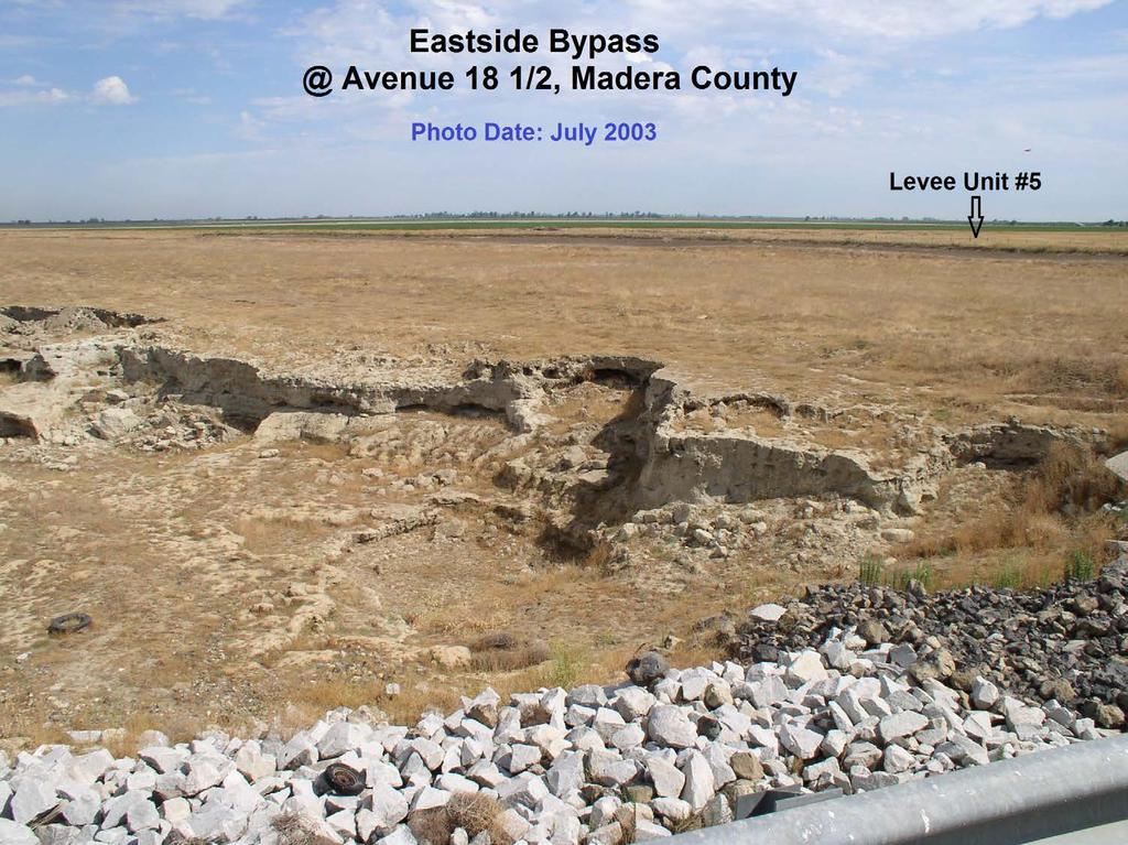
8 Approximate location of maximum subsidence in the United States identified by research efforts of Dr. Joseph F. Poland (pictured). Signs on pole show approximate altitude of land surface in 1925, 1955, and (28 feet in 50 years,.56 feet/year) The site is in the San Joaquin Valley southwest of Mendota, California.
9
10 Short Term Subsidence Solutions Reduce deep well (sub-corcoran) pumping Existing wells: Convert pumping from primarily deep wells to primarily shallow wells on Triangle T at least 3,000 acre feet Substitute 2 deep wells on Vlot Property for 2 shallow wells on Triangle T 2,000 acre feet Fallow late year forage crops and purchase feed from an outside source: 160 to 300 acres Secure and distribute supplemental water supply from an outside source Total 2013 reduction in deep well pumping (Due to management practices) 1,000 acre feet 3,000 acre feet 6,000 to 9,000 acre feet Reduction in deep well pumping due to crop changes. (Temporary until crop matures) 15,000 + acre feet


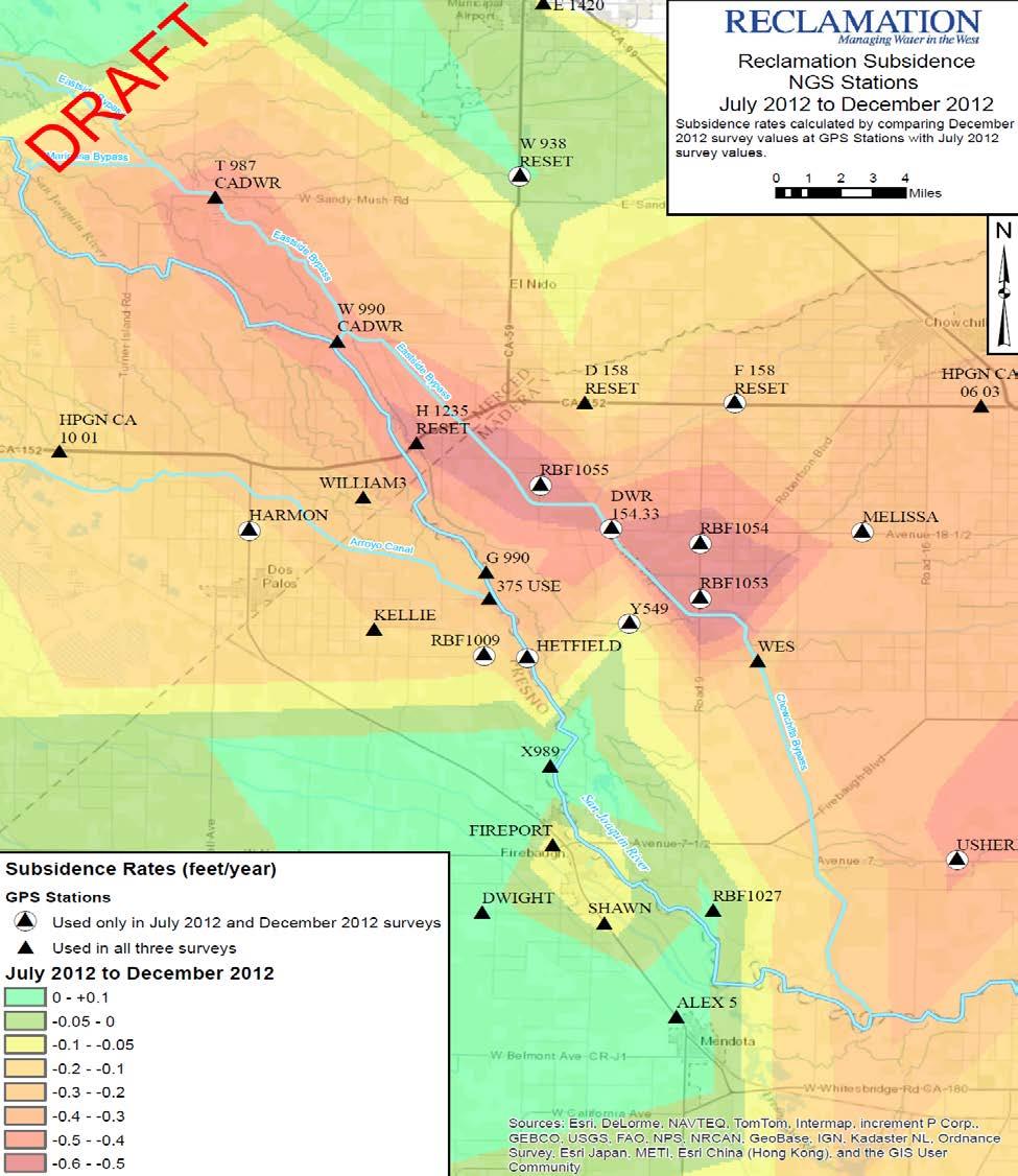
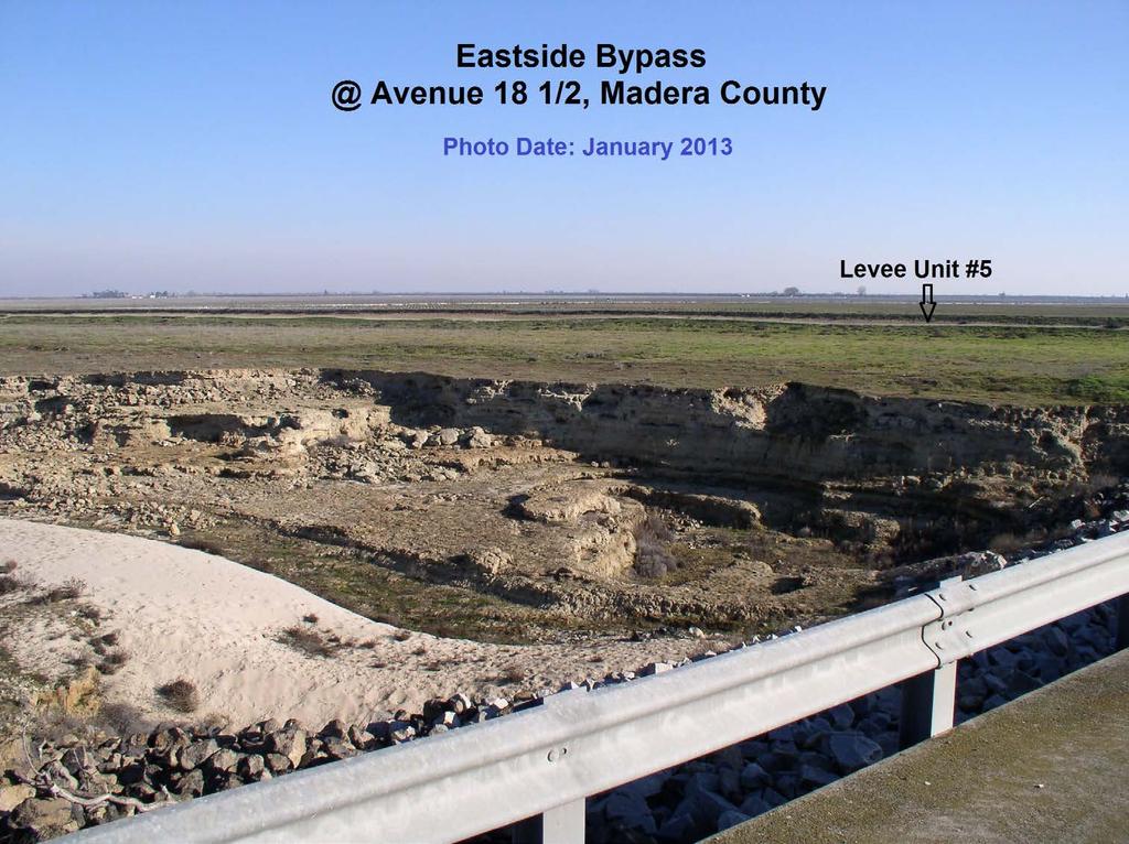
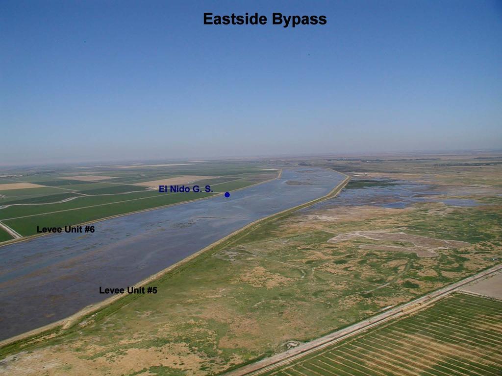
11 Water Level Elevations and Direction of Groundwater Flow in the Upper Aquifer N 11 Jan.-Feb Jan.-Feb. 2013


12 Water Level Elevations and Direction of Groundwater Flow in the Upper Aquifer Sack Dam to Eastside Bypass Comparison N 12 Jan.-Feb Jan.-Feb. 2013


13 Water Level Elevations and Direction of Groundwater Flow in the Lower Aquifer N 13 Jan.-Feb Jan.-Feb. 2013


14 Water Level Elevations and Direction of Groundwater Flow in the Lower Aquifer Sack Dam to Eastside Bypass Comparison N Jan.-Feb Jan.-Feb

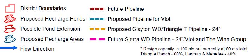
15 Alignments for Clayton WD and Sierra WD Irrigation Conveyance 15


16 Western Madera County Subsidence Study Long Term Solutions Continue grower-driven process to revive existing districts, form a new district, and/or annex into Madera Irrigation District. Develop Recharge Ponds and Turnouts from the Bypass (existing and proposed). The target schedule is to submit applications for permits this fall. Replace deep wells with shallow aquifer wells. Construct internal conveyance infrastructure improvements. 16


17 Subsidence Area District Vicinity Study Area 17


18 Western Madera County Subsidence Area Base-map with Recharge Ponds and Conveyance Facilities 18

19 Western Madera County Subsidence Solution Cost Summary 19 Participation in the Madera Water Bank provides guaranteed new supplemental supply that does not compete with existing scarce water supplies south of the Delta.
20 Subsidence Study Ongoing Coordination Efforts Coordinate with landowners. Coordinate solutions with County Boards of Supervisors. Coordinate with adjacent water and irrigation districts. Work with DWR on determining flood carrying capacity of Bypass and SJR. Work with reservoir operators on coordinated releases to minimize flood risk. Coordinate efforts with the SJR Restoration Program. Continue subsidence monitoring network. 20
21 Western Madera County Project Question Will the County support the organization of the landowners in the project area into an Irrigation District for the purposes of solving the Red Top subsidence problem? Well Construction Question Will the County allow combination (above and below Corcoran Clay) wells? Project Participation Question Given the public safety concern with subsidence impacts on the flood control system and to other adjacent facilities, what will be the County s participation in the project now and in the future? 21
 826-5112 Email: churley@slcc.net Rick Iger, Provost & Pritchard Consulting Group Cell Phone: (661) 303-6607 E-mail: riger@ppeng.")
22 Contact Information Chris White, Central California Irrigation District Office Phone: (209) Chase Hurley, San Luis Canal Company Office Phone: (209) Rick Iger, Provost & Pritchard Consulting Group Cell Phone: (661) In Association with Washington Avenue Growers, Red Top Area Growers, Merced and Madera Counties
Acres Monterey County, California OPEN GROUND IN SALINAS VALLEY VEGETABLE AND STRAWBERRY PROPERTY
 324 +- Acres Monterey County, California OPEN GROUND IN SALINAS VALLEY VEGETABLE AND STRAWBERRY PROPERTY EXCLUSIVELY PRESENTED BY: Morris Garcia License 00834407 (559) 994-7453 Cell Sarah Donaldson License
SALYER LAND COMPANY. Kings and Tulare Counties, California. 1,849.47± Assessed Acres. Exclusively Presented by: Pearson Realty
 Kings and Tulare Counties, California 1,849.47± Assessed Acres F & J Blocks Chandler Ranch Dairy Avenue Ranch Exclusively Presented by: Pearson Realty Offices Serving The Central Valley FRESNO VISALIA
SECTION 3 GENERAL DESCRIPTION OF THE RIVER BASIN
 SECTION 3 GENERAL DESCRIPTION OF THE RIVER BASIN SECTION 3 GENERAL DESCRIPTION OF THE RIVER BASIN River basin description. A general description of the river basin or subbasin, as appropriate, in which
A Comparison of the Salar de Atacama and Clayton Valley Lithium Ore Deposits: Groundwater Mining in the some of the Driest Places on Earth
 A Comparison of the Salar de Atacama and Clayton Valley Lithium Ore Deposits: Groundwater Mining in the some of the Driest Places on Earth Melissa Jennings Geologist & Environmental Engineer This presentation
BIG HORN RIVER. Big Horn Canal Bluff Fritz Highland Hanover Kirby Lower Hanover Lucerne Tillard Upper Hanover
 BIG HORN RIVER Big Horn Canal Bluff Fritz Highland Hanover Kirby Lower Hanover Lucerne Tillard Upper Hanover DESCRIPTION AND OPERATION MEMORANDUM BIG HORN CANAL USGS ID 4418 D1, 4418 C1, 4417 C8, 4418
AGRICULTURAL LAND ±197 AC HENRY MILLER RD, LOS BANOS, CA 93635
 Turner Island Rd, MERCED COUNTY Santa Fe Grade SITE CONTACT US RANDY GRIMSMAN Senior Vice President +1 916 446 8745 randall.grimsman@cbre.com www.cbre.com/randall.grimsman Lic. 00857338 CBRE, Inc. 500
13.1 REGIONAL TOURISM ISSUES AND SUMMARY OF FINDINGS
 13 REGIONAL TOURISM T he County of Mariposa s recreation needs and facilities fall within two categories: regional tourism and local recreation. This Element focuses on regional tourism issues related
LAND FOR SALE SUBDIVISION LAND: SFR DEVELOPMENT LAND OF ±100 HOMES Ave 13 1/2, Madera, CA PROPERTY FEATURES
 SALE PRICE: $1,795,000 PRICE PER LOT: $18,505 PRICE PER SF: $2.35 LOT SIZE: 17.48 Acres APN #: 034-151-018 & -019 ZONING: PUD 6,000 R-1 Residential MARKET: City Of Madera PROPERTY FEATURES Shovel-ready
Parks & Recreation Areas Program
 PARKS & RECREATION Parks & Recreation Areas Program As part of its mission to conserve and protect natural resources, the Upper Big Blue Natural Resources District (NRD) has been involved in several large-scale
PPCR/SC.4/5 October 9, Meeting of the PPCR Sub-Committee Washington, D.C. October 28, REVIEW OF ON-GOING WORK OF THE MDBs IN DJIBOUTI
 PPCR/SC.4/5 October 9, 2009 Meeting of the PPCR Sub-Committee Washington, D.C. October 28, 2009 REVIEW OF ON-GOING WORK OF THE MDBs IN DJIBOUTI Proposed Sub-Committee Decision The Sub-Committee reviewed
520± Acre. Las Aldeas Farm. Imperial Valley, CA. agribusiness solutions team. Curtis Buono CA Lic.
 520± Acre Las Aldeas Farm Imperial Valley, CA agribusiness solutions team Curtis Buono 858.558.5629 curtis.buono@cushwake.com CA Lic. #1894905 Matt Davis 858.334.4026 matt.davis@cushwake.com CA Lic. #1758818
SAN ANTONIO RIVER IMPROVEMENTS PROJECT. April 27, 2009
 SAN ANTONIO RIVER IMPROVEMENTS PROJECT April 27, 2009 1 Project Limits 2 Project Partners City of San Antonio Provides project funding for project amenities (i.e.. Sidewalks, Landscaping, Lighting, etc.)
Preferred Recreation Recommendations Stemilt-Squilchuck Recreation Plan March 2018
 Preferred Recreation Recommendations Stemilt-Squilchuck Recreation Plan March 2018 Below are the recommended recreation ideas and strategies that package together the various recreation concepts compiled
The Sand Ridge - Tulare Lake Conservation Report proposes the following recommendations:
 Introduction Creighton Ranch. Pixley National Wildlife Refuge. Allensworth State Historic Park. Sand Ridge. Deer Creek. Located in the Tulare Lake Basin, the Sand-Ridge - Tulare Lake Planning Area features
MEETING OF THE METROPOLITAN PARKS AND OPEN SPACE COMMISSION Tuesday, April 4, 2017
 Minutes of the MEETING OF THE METROPOLITAN PARKS AND OPEN SPACE COMMISSION Tuesday, April 4, 2017 Committee Members Present: Tony Yarusso, Rick Theisen, Robert Moeller, Todd Kemery, Sarah Hietpas, Margie
Industrial Investment Property
 Industrial Investment Property Fully Leased NNN Investment 2945-2965 SOUTH ANG AVENUE - FRESNO, CALIFORNIA BUILDING FEATURES 24-27 CEILING HEIGHT 60 X 28 COLUMN SPACING CONCRETE TILT-UP CONSTRUCTION FULLY
Insights in the water-energy-food nexus in the Nile Basin with the new Eastern Nile Water Simulation Model
 Insights in the water-energy-food nexus in the Nile Basin with the new Eastern Nile Water Simulation Model Wil N.M. van der Krogt, Henk J.M. Ogink For International Conference Sustainability in the WaterEnergy-Food
One Source, Multiple Challenges: The Future Evolution of Water Policy and the Case of the Colorado River
 One Source, Multiple Challenges: The Future Evolution of Water Policy and the Case of the Colorado River David H. Getches Dean and Raphael J. Moses Professor of Natural Resources Law University of Colorado
Lake Chelan Operations
 Lake Chelan Operations IPMA Executive Seminar September 17, 2013 Presented by: Janet Jaspers Chelan County PUD Lake Chelan Hydroelectric Project Today s Discussion Chelan PUD Overview Interesting Facts
Successful Experiences in Rio Grande/Rio Bravo Watershed Management
 Successful Experiences in Rio Grande/Rio Bravo Watershed Management 5 th th World Water Forum Istanbul, Turkey March 22-23, 23, 2009 Introduction A watershed with many voices a medley of cultures, customs,
EL PASO S DESALINATION EFFORTS
 El Paso s Desalination Efforts WATER DESALINATION AND REUSE STRATEGIES FOR NEW MEXICO SEPTEMBER NEW MEXICO WATER RESOURCES RESEARCH INSTITUTE 2004 Bill Hutchison has more than 20 years of experience as
Upper Feather River Integrated Regional Water Management Planning Area. Administrative Boundaries
 L a s s e n V o l c a n i c W i l d e r n e s s L a s s e n V o l c a n i c Administrative Boundaries Bucks IRWM Hydroelectric Plant Sierra Sierra Canal or Ditch Pipeline, Aqueduct, Penstock National Forest
Regional Jets ,360 A319/ , , , ,780
 Excel Tab Name: Seats (18 MAP) PASSENGER AIRLINE FLIGHT SCHEDULE CALCULATION RECORD Summary 17.2 MAP flight schedule* (with Southwest Airlines B737-800s changed to B737-700s) Number of Total Seats Avg.
TRINITY RIVER CORRIDOR
 TRINITY RIVER CORRIDOR MODIFIED DALLAS FLOODWAY PROJECT UPDATE May 12, 2015 Jon Loxley Project Manager Dallas Floodway Project Fort Worth District U.S. Army Corps of Engineers US Army Corps of Engineers
Big Sandy Ranch Mohave County, Arizona
 Big Sandy Ranch Mohave County, Arizona Photo [9] Deeded land on hillside within the River Ranch parcel Listed for sale exclusively by: Traegen Knight Headquarters West Ltd. PO BOX 1980 St. Johns, AZ 85936
BUILD. In this issue: NEW AERIALS OF CONSTRUCTION NEW PROJECT IN CONSTRUCTION PAC K AG E 4. August 2018
 BUILD C O N ST R U C T I O N Update August 2018 In this issue: NEW AERIALS OF CONSTRUCTION NEW PROJECT IN CONSTRUCTION PAC K AG E 4 AVENUE 12 CEDAR VIADUCT A VIEW FROM ROAD 27 ABOVE HSR CONSTRUCTION FRESNO
1803 West Hwy 160 Monte Vista, CO (719) TTY (719)
 TTY (719)") USDA Forest Service Rio Grande National Forest http://www.fs.fed.us/r2/riogrande 1803 West Hwy 160 Monte Vista, CO 81144 (719)852-5941 TTY (719)852-6271 USDI Bureau of Land Management San Luis Valley Center
USDA Forest Service Rio Grande National Forest http://www.fs.fed.us/r2/riogrande 1803 West Hwy 160 Monte Vista, CO 81144 (719)852-5941 TTY (719)852-6271 USDI Bureau of Land Management San Luis Valley Center
The Wilderness Act of Cecilia Reed, Forest Service Mokelumne Wilderness Manager
 The Wilderness Act of 1964 Cecilia Reed, Forest Service Mokelumne Wilderness Manager Aldo Leopold Arthur Carhart Teddy Roosevelt The Wilderness Act of 1964 After much debate and compromise after 66 drafts,
3.0 OVERVIEW OF HUECO BOLSON
 3.0 OVERVIEW OF HUECO BOLSON The Hueco Bolson covers about 2,500 square miles, or 1.6 million acres in New Mexico, Texas, and Chihuahua (Figure 3-1). In Texas, the Hueco overlies portions of El Paso and
SECTION 55A1 ROBINSON TOWNSHIP IN WASHINGTON COUNTY
 WEEK ENDING FEBRUARY 1, 2019 SECTION 55A1 ROBINSON TOWNSHIP IN WASHINGTON COUNTY Contractor: Independence Excavating Inc. 1. Work Shift Day shift (M-F), with Saturday as a makeup day. 2. Traffic The new
David Johnson. Tom, Attached please find the final scoping letter and figures for your review. David
 David Johnson From: Sent: To: Cc: Subject: Attachments: David Johnson Tuesday, April 12, 2011 4:33 PM Thomas Malecek Dave Dyer; Jason Marks (jmarks@segroup.com) VWC Scoping Letter
HIGH COUNTRY L-BAR RANCH
 HIGH COUNTRY L-BAR RANCH Sandoval and mckinley counties N e w m e x i c o Jim Haworth, Ranch Team Lead Broker ~ 505-235-5236 3613 NMSR 528 NW, Ste. H, Albuquerque, NM 87114 505-792-3713 www.wwrealty.com
Fabulous Residential Development Site on the Peninsula
 500 SYLVAN AVENUE SAN BRUNO, CALIFORNIA Fabulous Residential Development Site on the Peninsula ED STEPHENS Broker Associate calbre # 00462186 Page 1 Cell: (650) 208-1301 EdStephensRealEstate@gmail.com
Terrestrial Protected Area Nomination: Central Mangrove Wetland South-West, Grand Cayman
 Terrestrial Protected Area Nomination: Central Mangrove Wetland South-West, Grand Cayman The attached nomination, proposing that a parcel of land in the Central Mangrove Wetland be made a Protected Area
VI. ALTERNATIVES TO THE MASTER PLAN C. RENOVATED EAST BUILDING ALTERNATIVE
 VI. ALTERNATIVES TO THE MASTER PLAN C. RENOVATED EAST BUILDING ALTERNATIVE INTRODUCTION The Renovated East Building Alternative would include the continued use of the renovated West Building and the renovation
The St. Joe Company. Raymond James Institutional Investors Conference March 10, 2009
 The St. Joe Company Raymond James Institutional Investors Conference March 10, 2009 Forward Looking Statements This presentation contains forward-looking statements about future events that are subject
EAST DON TRAIL ENVIRONMENTAL ASSESSMENT. Community Liaison Committee Meeting #3 July 15, :30 to 8:30 pm Flemingdon Park Library
 EAST DON TRAIL ENVIRONMENTAL ASSESSMENT Community Liaison Committee Meeting #3 July 15, 2013 6:30 to 8:30 pm Flemingdon Park Library Agenda 1. Welcome 2. Housekeeping and Updates a) Housekeeping b) CLC
Arrowhead Ranch. Located in the Big Range Country of Central Wyoming.
 Arrowhead Ranch Located in the Big Range Country of Central Wyoming. 58 E. Benteen Street Buffalo, WY 82834 Ph 307-684-9556 Toll Free 888-684-9557 Fax 307-684-8565 Location The ranch is approximately:
N Prime Retail Pads w/ Direct CA-99 & Betty Dr Access. Direct Access to Upgraded HWY 99 Off/On Ramps
 Prime Retail Pads w/ Direct CA-99 & Betty Dr Access Direct Access to Upgraded HWY 99 Off/On Ramps Optimal Visibility w/ Easy to - Over 70,000 Cars Per Day Unmatched Level of Consumer Traffic & High Volume
The Benefits of a Whittier Blvd. Alignment for the Metro Eastside Extension
 The Benefits of a Whittier Blvd. Alignment for the Metro Eastside Extension by Bart Reed The Transit Coalition P.O. Box 567 San Fernando, CA 91341-0567 (818) 367-1661 1 Introduction Metro has released
Final Environmental Impact Statement for the Merced Wild and Scenic River. Comprehensive Management Plan, Yosemite National Park, Madera and Mariposa
 This document is scheduled to be published in the Federal Register on 02/26/2014 and available online at http://federalregister.gov/a/2014-04061, and on FDsys.gov DEPARTMENT OF THE INTERIOR 4312-FF NATIONAL
Survey of Rodman Reservoir and middle-ocklawaha River springs during spring 2008 draw-down conditions: FWC and FWS
 Survey of Rodman Reservoir and middle-ocklawaha River springs during spring 2008 draw-down conditions: FWC and FWS Date of Survey: February 26, 2008 Survey conducted by: Dawn Jennings, USFWS Nicole Adimey,
SUPER VACANT LAND REAL ESTATE OPPORTUNITIES
 SUPER VACANT LAND REAL ESTATE OPPORTUNITIES ESTATE SALE Panama City - Bay County, Florida - Northwest Florida 12 VACANT LAND PARCELS AVAILABLE From.72± Acres up to 130± Acres Available Waterfront and Interior
SAN ANTONIO RIVER IMPROVEMENTS PROJECT. August 6, 2008
 SAN ANTONIO RIVER IMPROVEMENTS PROJECT August 6, 2008 1 History of the SA River Improvements 1921 Flood Olmos Dam Complete in 1929 Downtown Flood Relief Projects in 1950 s Dams on the River Channel and
Attachment O Verified Statement of Christopher Banet Page 1 of 7
 Attachment O Verified Statement of Christopher Banet Page 1 of 7 Attachment O Verified Statement of Christopher Banet Page 2 of 7 Curriculum Vitae Education Christopher Banet United States Department of
CHAPTER 7 DISTRIBUTION LIST
 CHAPTER 7 DISTRIBUTION LIST Notices of Availability of this Draft Environmental Impact Report/ Draft Environmental Impact Statement (DEIR/DEIS) have been sent to all property owners within a one and a
Mather Restoration Advisory Board (RAB) Meeting Draft Summary Meeting Minutes. Mather, California. 11 March 2009
 Meeting Draft Summary Meeting Minutes. Mather, California. 11 March 2009") Mather Restoration Advisory Board (RAB) Meeting Draft Summary Meeting Minutes 11 March 2009 Time: Place: 6:00 PM Air Force Real Property Agency (AFRPA) Conference Room 10503 Armstrong Avenue Mather, CA
Mather Restoration Advisory Board (RAB) Meeting Draft Summary Meeting Minutes 11 March 2009 Time: Place: 6:00 PM Air Force Real Property Agency (AFRPA) Conference Room 10503 Armstrong Avenue Mather, CA
$10,793,250 AVENUE 18 1/ ± acres. E xclus iv ely Pr esen t e d by : MADERA COUNTY ALMONDS. ( $25,000 per acre )
") AVENUE 18 1/2 E xclus iv ely Pr esen t e d by : M a d e r a C o u n t y, C A $10,793,250 ( $25,000 per acre ) CA BRE# 00020875 www.pearsonrealty.com AV ENU E 1 8 1/2 Lo c at i on The subject property is
AVENUE 18 1/2 E xclus iv ely Pr esen t e d by : M a d e r a C o u n t y, C A $10,793,250 ( $25,000 per acre ) CA BRE# 00020875 www.pearsonrealty.com AV ENU E 1 8 1/2 Lo c at i on The subject property is
Northern Rail Extension, Phase One
 General Project and Funding 1. Where does Phase One start? The rail line for Phase One begins roughly at the northern boundary of the former Bradbury property, but also includes work along Tom Bear Trail
Lake Manitoba Lake St. Martin
 Lake Manitoba Lake St. Martin Outlet Channels Public Information Session June 29, 2017 July 13, 2017 Background & History 2011 Spring Flood Event High flows recorded on most streams and rivers in the Assiniboine
Frizzell Creek Ranch Summerville, OR $1,400, ± Acres
 Frizzell Creek Ranch Summerville, OR $1,400,000 165± Acres 1 Introduction The Frizzell Creek Ranch is a beautiful 165± acre ranch located in northeast Oregon at the base of the Wallowa Whitman National
155 acres on Tyaughton Lake 900 feet of Pristine Waterfront Private & Secluded Property
 155 acres on Tyaughton Lake 900 feet of Pristine Waterfront Private & Secluded Property 946 Tyaughton Lake Road Gold Bridge BC V0K1P0 900 ft of waterfront with 155 acres of south facing easy access. This
Unit 9 The Middle East SG 1 - Physical Geography, Population & Demographics
 Unit 9 The Middle East SG 1 - Physical Geography, Population & Demographics I. Physical Geography A. The Middle East includes southwestern Asia and North Africa. 1. The name is Eurocentric. Middle East
5 Acres of Commercial Land - Los Banos, CA
 5 Acres of Commercial Land - Los Banos, CA Hwy 152 Major Credit All or Part $2,300,000 Subject Property Renz & Renz George L. Renz, CCIM george@renzrenz.com 408.846.1031 Summary of Salients 5 Acres of
MANAGING FRESHWATER INFLOWS TO ESTUARIES
 MANAGING FRESHWATER INFLOWS TO ESTUARIES Yuna River Hydrologic Characterization A. Warner Warner, A. (2005). Yuna River Hydrologic Characterization. University Park, Pennsylvania: The Nature Conservancy.
CASE NO. 2019CW10 (REF NO. 12CW118).
.") IN THE DISTRICT COURT IN AND FOR WATER DIVISION NO. 4 STATE OF COLORADO TO: ALL PERSONS INTERESTED IN WATER APPLICATIONS IN SAID WATER DIVISION NO. 4 Pursuant to C.R.S. 37-92-302, as amended, you are notified
IN THE DISTRICT COURT IN AND FOR WATER DIVISION NO. 4 STATE OF COLORADO TO: ALL PERSONS INTERESTED IN WATER APPLICATIONS IN SAID WATER DIVISION NO. 4 Pursuant to C.R.S. 37-92-302, as amended, you are notified
CREATING CONNECTIONS IN THE CITY OF NIAGARA FALLS PUBLIC MEETING DECEMBER 6, 2017
 CREATING CONNECTIONS IN THE CITY OF NIAGARA FALLS PUBLIC MEETING DECEMBER 6, 2017 CONGESTION COSTS OUR ECONOMY The average commute in Ontario is already over 45 minutes, and that figure jumps to more than
REQUEST FOR COUNCIL ACTION
 REQUEST FOR COUNCIL ACTION Date: 10-24-2016 Item No.: 14.e Department Approval City Manager Approval Item Description: Roseville Deer Management 1 2 3 4 5 6 7 BACKGROUND The City of Roseville, in conjunction
VOLUME II APPENDIX F DETAILED PHYSICAL DESCRIPTION OF PROJECT RESERVOIRS AND LANDS
 VOLUME II APPENDIX F DETAILED PHYSICAL DESCRIPTION OF PROJECT RESERVOIRS AND LANDS THE CENTRAL NEBRASKA PUBLIC POWER AND IRRIGATION DISTRICT FERC PROJECT NO. 1417 PHYSICAL DESCRIPTION OF PROJECT LANDS
Mr. Michael Malone CPS Energy 145 Navarro Street San Antonio, Texas Project No
 January 15, 2016 Mr. Michael Malone 145 Navarro Street San Antonio, Texas 78205 Project No. 0328985 Environmental Resources Management CityCentre Four 840 West Sam Houston Pkwy N. Suite 600 Houston, Texas
Massport and FAA RNAV Pilot Study Overview Briefing to Massport CAC. December 8, 2016
 Massport and FAA RNAV Pilot Study Overview Briefing to Massport CAC December 8, 2016 Contents FAA/Massport RNAV MOU Context Boston Logan Context FAA RNAV MOU, Overview Q&A 12/8/2016 2 FAA/Massport RNAV
SEC Highways 41 & 145
 FOR SALE ±1,221 ACRES OF LAND SEC Highways 41 & 145 MADERA COUNTY, CALIFORNIA Asking Price: $23,216,000 BOBBY FENA, SIOR 559 256 2436 bobby.fena@colliers.com License No. 00590204 JACK MESSINA 559 256 2442
Electrical Quarterly Load Update
 Electrical Quarterly Load Update Photo: Sunset Marina, Lake Chelan January 7, 2019 Andy Wendell Director of Customer Services Chad Rissman Director of Engineering & Asset Management Today s Agenda New
Airport Planning Area
 PLANNING AREA POLICIES l AIRPORT Airport Planning Area LOCATION AND CONTEXT The Airport Planning Area ( Airport area ) is a key part of Boise s economy and transportation network; it features a multi-purpose
HIGHWAY 17 WILDLIFE and REGIONAL TRAIL CROSSINGS
 HIGHWAY 17 WILDLIFE and REGIONAL TRAIL CROSSINGS Agenda and Meeting Format 7:00-7:15 Welcome 7:15-8:00 Presentation 8:00-8:30 Open House 8:30 Recap 9:00 Conclusion 2 Meeting Goals: Introduce the project
Panama Business Day- Hamburg. BAUER Fundaciones Panamá S.A.
 Panama Business Day- Hamburg BAUER Fundaciones Panamá S.A. Opportunities in Infrastructure Development and Public Projects in Panama and beyond Hans Schwarzweller October 2016 BAUER Spezialtiefbau GmbH,
This section evaluates the projected traffic operations and circulation impacts associated with the proposed upgrade and expansion of the LWRP.
 4.5 TRAFFIC AND CIRCULATION This section evaluates the projected traffic operations and circulation impacts associated with the proposed upgrade and expansion of the LWRP. 4.5.1 Environmental Setting Existing
PASSPORT. Discovering the Trails of Webster, NY
 PASSPORT to family wellness Discovering the Trails of Webster, NY Join the Friends of Webster Trails, Webster Health and Education Network, The Town of Webster and Wegmans to get moving more and enjoy
Comparative Debt Measures California Counties As of June, Summary
 Supplemental Data Sheet Comparative Debt Measures California Counties As of June, 2007 Summary Based on data in the most recent SCO Counties Annual Report (2007), compared to all other California Counties,
Tonopah Irrigation District
 Tonopah Irrigation District Presentation to Arizona Power Authority Concerning 2017 Hoover Process and District s Needs October 24, 2012 Elizabeth Story, Administrator Location Tonopah Irrigation District
Mission Statement. Spur 601 Project Highlights
 Mission Statement SPUR 601 is a TxDOT project dedicated to provide a safe, efficient, reliable new corridor to improve the mobility in east-central El Paso. The SPUR 601 team is working in partnership
ALPINE PIPELINE RIVER CROSSINGS 2009 MONITORING REPORT
 ALPINE PIPELINE RIVER CROSSINGS 2009 MONITORING REPORT Submitted to ConocoPhillips Alaska, Inc. Submitted by Michael Baker, Jr., Inc. 1400 West Benson Blvd., Suite 200 Anchorage, Alaska 99503 TABLE OF
ICPDR FP-EG project overview
 ICPDR FP-EG project overview 9 th Steering Group meeting of PA5 of the EUSDR Management of Environmental Risks KÁROLY GOMBÁS CHAIRMAN FLOOD PROTECTION EXPERT GROUP (FP-EG) INTERNATONAL COMISSION OF THE
B R O O K S S U B D I V I S I O N
 CANADIAN PACIFIC RAILWAY B R O O K S S U B D I V I S I O N - PART 2 - BROOKS TO BASSANO, ALBERTA - C. van Steenis, Chestermere, Alberta 30 Oct 2009 The Canadian Pacific Railway built the transcontinental
A Brief Overview of the Rio Grande Compact 04/26/06
 A Brief Overview of the Rio Grande Compact 04/26/06 The New Mexico Interstate Stream Commission Investigate, Protect, Conserve, and Develop the State s Waters and Stream Systems Negotiate and Administer
Phoenix Habitat Restoration Projects
 Phoenix Habitat Restoration Projects Spur Cross Ranch Cave Creek (Estergard) Regional Tree and Shade Summit March 9, 2010 Desert Riparian Ecosystems Healthy riparian areas like this once existed along
SR 520 Program. The road to the world s longest floating bridge. August 2015
 SR 520 Program The road to the world s longest floating bridge August 2015 Chris Christopher, P.E. Director of Construction - WSDOT AASHTO Subcommittee on Construction August 2015 Little Rock, Arkansas
Existing Resource Information
 Botanical and Wildlife Vegetation alliances/wildlife habitats Grasslands annual/perennial Chaparral mixed/montane/chamise-redshank Riparian montane/valley foothill riparian Sierran mixed conifer Montane
Initial OPW Designation APSR AFRR IRR Co-ordinates Easting: Northing: River / Catchment / Sub-catchment Type of Flooding / Flood Risk
 Location: Shannon International Airport, Co. Clare Unique ID: 275484 (from PFRA database) Initial OPW Designation APSR AFRR IRR Co-ordinates Easting: 137674 Northing: 161045 River / Catchment / Sub-catchment
Madera County Transportation Commission Madera County Grand Jury Final Report
 Madera County Transportation Commission 2017-18 Madera County Grand Jury Final Report 1718-07 Published on: May 14, 2018 2017-2018 Madera County Grand Jury Final Report 1718-07 Madera County Transportation
December 2012 Passenger and Cargo Traffic Statistics Reno-Tahoe International Airport
 December 2012 Passenger and Cargo Traffic Statistics Reno-Tahoe International Airport January 29, 2013 U.S. DOMESTIC INDUSTRY OVERVIEW FOR DECEMBER 2012 All RNO Carriers Systemwide year over year comparison
Cherokee And The Concow Dam
 Cherokee And The Concow Dam In 1853 Sol Potter, a school teacher from the Cherokee Nation in Oklahoma along with several students discovered gold in Butte County and named the area Cherokee. Others soon
ANGLIAN WATER GREEN BOND
 ANGLIAN WATER GREEN BOND DNV GL ELIGIBILITY ASSESSMENT Scope and Objectives Anglian Water Services Financing Plc is the financing subsidiary of Anglian Water Services Limited. References in this eligibility
SUTTER COUNTY. General Plan Update Technical Background Report
 SUTTER COUNTY General Plan Update Technical Background Report February 2008 SUTTER COUNTY GENERAL PLAN UPDATE TECHNICAL BACKGROUND REPORT PREPARED FOR: SUTTER COUNTY PREPARED BY: PBS&J IN PARTNERSHIP
To all our cooperators from across California. be they ranchers, growers, or regulators, activists, resource managers, and the public THANK YOU!
 Managing Rangeland sheds for Agricultural Production, Quality, and Food Safety To all our cooperators from across California be they ranchers, growers, or regulators, activists, resource managers, and
Pinecrest DICKINSON NORTH DAKOTA COMMONS TAKING ROOT IN THE BAKKEN.
 Pinecrest TAKING ROOT IN THE BAKKEN. COMMONS DICKINSON NORTH DAKOTA About The Trade Area About The Development Over 30 acres of commercial / retail land being developed Over 30 acres of office land being
AGENDA ITEM _C2 TAMPA WATER. Completion Date
 TAMPA WATER Supply'mfl Water To The Region AGENDA ITEM _C2 DATE: February 6, 2007 TO: J err y L. Maxwell, General Manager FROM: Donald J. Polmann, Director of Science and Engineering SUBJECT: New Water
Chapter 17. North Africa, Southwest Asia and Central Asia
 Chapter 17 North Africa, Southwest Asia and Central Asia Chapter Objectives Describe the major landforms and natural resources of North Africa, Southwest Asia, and Central Asia. Discuss the climate and
Region of Waterloo Transportation and Environmental Services Transit Services
 Region of Waterloo Transportation and Environmental Services Transit Services To: Chair Tom Galloway and Members of the Planning and Works Committee Date: File Code: T19-50 Subject: Transit Services ION
Norfolk District North Atlantic Division
 Norfolk District North Atlantic Division Eastern Chapter of WEDA Fall Conference October 26, 2016 Stephen J. Powell, P.E. (757) 201-7788 US Army Corps of Engineers Norfolk District FY-17 Dredging Program
Bradley M. Hill, R.G.
 Presented by Bradley M. Hill, R.G. Utilities Director City of Flagstaff Western Governor s Association Western States Water Council Phoenix, Arizona November 14-16, 2012 1 Downtown Flagstaff Grand Canyon
air traffic statistics
 September 213 air traffic statistics Prepared by the Office of Finance Department of Internal Controls, Compliance and Financial Strategy Commercial Total Int'l Dom Passengers % Change Air Traffic Summary
90 I-90 Snoqualmie Pass East September Annual Mega-Project Report. Project Benefits
 90 I-90 Snoqualmie Pass East September 2015 Annual Mega-Project Report Purpose of this Report The financial and schedule information in this document will assist the Office of Financial Management in meeting
Presented to: City of Petaluma City Council
 Agenda Item #1.A REVISED Presented to: City of Petaluma City Council Presented By: Dan St. John, F.ASCE, Director Jason Beatty, P.E., Senior Engineer James 'Jody' Boyette, USACE Project Manager November
Juvenile coho salmon use of constructed off-channel habitats in two Lower Klamath River tributaries: McGarvey Creek & Terwer Creek
 Juvenile coho salmon use of constructed off-channel habitats in two Lower Klamath River tributaries: McGarvey Creek & Terwer Creek Prepared by: Yurok Tribal Fisheries Program PO Box 1027, Klamath, CA Spring
Summary table of disaster occurrences, by hazards types, scale, and geographic region
 ANNEX BASIC RANGE OF DISASTER-RELATED STATISTICS TABLES Statistical tables are organised into worksheets according to basic components in the DSRF. The variables represent queries from a disaster-related
LOVE FIELD ENVIRONMENTAL ADVISORY COMMITTEE QUARTERLY REPORT. October December 2016
 LOVE FIELD ENVIRONMENTAL ADVISORY COMMITTEE QUARTERLY REPORT October December 2016 VOLUNTARY NOISE CONTROL PROGRAM COMPLIANCE DURING PREFERENTIAL HOURS 2100 0600 (JAN SEP 2016) 2 PERCENTAGE OF COMPLIANCE
DRAFT. Dorabelle Campground Rehabilitation
 DRAFT Dorabelle Campground Rehabilitation September 2012 1.1 REGIONAL SETTING AND PROJECT LOCATION The Dorabelle Campground is located on the western shore of Shaver Lake in Fresno County, California (Section
The St Joe Compan November 2009
 The St. Joe Company November 2009 Forward Looking Statements e ts This presentation contains forward-looking statements about future events that are subject to numerous assumptions, risks and uncertainties.
Paso Robles Groundwater Basin: Effects of Geothermal Waters on Water Quality and Availability
 Paso Robles Groundwater Basin: Effects of Geothermal Waters on Water Quality and Availability Jim Rytuba and Daniel Goldstein U.S. Geological Survey, Menlo Park, CA Paso Robles Intake from Lake Nacimiento