NATIVE FAUNA OF THE GREATER BLUE MOUNTAINS WORLD HERITAGE AREA
|
|
|
- Clinton Ryan
- 5 years ago
- Views:
Transcription


1 NATIVE FAUNA OF THE GREATER BLUE MOUNTAINS WORLD HERITAGE AREA MAMMALS

2 NATIVE FAUNA OF THE GREATER BLUE MOUNTAINS WORLD HERITAGE AREA MAMMALS Version 3 Judy Smith and Peter Smith March 2017 This project was supported through funding from the Australian Government s Community Heritage and Icons Grants Programme Judy and Peter Smith This work is copyright. Apart from any use permitted under the Copyright Act 1968, no part may be reproduced or distributed by any process, nor stored in any database or retrieval system, nor may any other exclusive right be exercised, without the prior written permission of Judy and Peter Smith. Cover illustration of Greater Glider by Kate Smith katesmithart@gmail.com
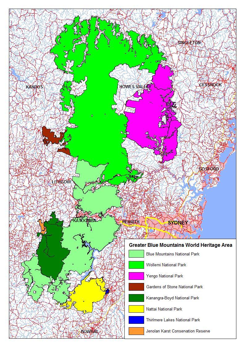
3 Contents Page Introduction 1 Map of Greater Blue Mountains World Heritage Area 2 Table of species 3 Species accounts 6 Sources 25 Introduction The Greater Blue Mountains World Heritage Area comprises eight reserves: Blue Mountains, Gardens of Stone, Kanangra-Boyd, Nattai, Thirlmere Lakes, Wollemi and Yengo National Parks, and Jenolan Karst Conservation Reserve. The area was inscribed on the World Heritage List in 2000 because its natural values, including the diversity of its fauna, were considered to be outstanding at international level. In 1998, when the nomination of the Greater Blue Mountains Area for inscription on the World Heritage List was prepared for the Australian Government, it was well known that the area provided habitat for a wide variety of mammals, birds, reptiles and amphibians. However, details of the vertebrate fauna were sketchy. The nomination indicated that about 400 native terrestrial vertebrate fauna species had been recorded in the area, including 52 mammal, 265 bird, 63 reptile and more than 30 frog species. The diverse bird fauna included 25 species of honeyeaters, about one third of the Australian total. Over the last year, in an attempt to gain a clearer understanding of the vertebrate fauna, we have prepared four annotated checklists, one each for the native mammals, birds, reptiles and frogs in the Greater Blue Mountains World Heritage Area. The four checklists indicate the species we consider to have been reliably recorded in each of the eight constituent reserves since the time of European settlement. Details of the conservation status at national and state level, and habitat, distribution and relative abundance in the World Heritage Area are provided for each species. The checklists indicate that at least 423 native terrestrial vertebrate fauna species have been recorded in the Greater Blue Mountains World Heritage Area. This number includes 66 mammal species, of which 28 are threatened species. The Australian mammal fauna has had an alarming history of decline and extinction since European settlement, and nine of the mammal species recorded in the past in the World Heritage Area are now probably extinct there. Protection and rehabilitation of the mammal fauna should be a management priority. There are still many gaps in our knowledge of the fauna of the Greater Blue Mountains World Heritage Area. Updating the checklists is an on-going process. If you have additional records or other information, your feedback would be very welcome. Judy and Peter Smith 1
4 2
5 Native mammal species recorded in the Greater Blue Mountains World Heritage Area Status in NSW and Commonwealth legislation: C = critically endangered, E = endangered, V = vulnerable, X = extinct/presumed extinct GBMWHA reserves: BMNP = Blue Mountains National Park, GOSNP = Gardens of Stone National Park, JKCR = Jenolan Karst Conservation Reserve, KBNP = Kanangra-Boyd National Park, NNP = Nattai National Park, TLNP = Thirlmere Lakes National Park, WNP = Wollemi National Park, YNP = Yengo National Park Species nomenclature follows Van Dyck et al. (2013) and, for Mormopterus, Reardon et al. (2014). Subspecies follow Burbidge et al. (2014). 'Recent' records are 2000 or later, otherwise the date of the last record is specified. Includes records from skeletal material in cave deposits at Jenolan Caves (Morris et al. 1997), but only if the material dates from after European settlement. Scientific name Common name Family Status Records in Greater Blue Mountains World Heritage Area reserves NSW Com BMNP GOSNP JKCR KBNP NNP TLNP WNP YNP Ornithorhynchus anatinus Platypus Ornithorhynchidae recent recent recent recent recent recent recent Tachyglossus aculeatus aculeatus Short-beaked Echidna Tachyglossidae recent recent recent recent recent recent recent recent Antechinus agilis Agile Antechinus Dasyuridae recent recent Antechinus flavipes flavipes Yellow-footed Antechinus Dasyuridae recent recent undated recent recent Antechinus stuartii Brown Antechinus Dasyuridae recent recent recent recent recent 1956 recent recent recent Antechinus swainsonii mimetes Dusky Antechinus Dasyuridae recent 1991 recent recent recent recent Dasyurus maculatus maculatus Spotted-tailed Quoll Dasyuridae V E recent recent recent recent recent recent Dasyurus viverrinus Eastern Quoll Dasyuridae E C extinct extinct Phascogale tapoatafa tapoatafa Brush-tailed Phascogale Dasyuridae V recent undated recent Sminthopsis murina murina Common Dunnart Dasyuridae recent recent recent 1998 recent recent recent recent Isoodon obesulus obesulus Southern Brown Bandicoot Peramelidae E E undated undated Perameles nasuta Long-nosed Bandicoot Peramelidae recent recent undated recent recent recent Phascolarctos cinereus Koala Phascolarctidae V V recent recent recent recent recent recent recent recent Vombatus ursinus hirsutus Common Wombat Vombatidae recent recent recent recent recent recent recent recent recent Cercatetus nanus unicolor Eastern Pygmy-possum Burramyidae V recent undated recent recent Petaurus australis australis Yellow-bellied Glider Petauridae V recent recent recent recent recent recent recent recent Petaurus breviceps breviceps Sugar Glider Petauridae recent recent recent recent recent recent recent recent recent Petaurus norfolcensis Squirrel Glider Petauridae V recent recent undated recent recent recent Petauroides volans volans Greater Glider Pseudocheiridae V recent recent recent recent recent recent recent recent recent Pseudocheirus peregrinus peregrinus/cookii Common Ringtail Possum Pseudocheiridae recent recent recent recent recent recent recent recent recent Acrobates pygmaeus/'frontalis' Narrow-toed/Broad-toed Feathertail Glider Acrobatidae recent recent recent recent recent recent recent recent Trichosurus caninus/cunninghami Short-eared/Mountain Brushtail Possum Phalangeridae recent recent recent recent Trichosurus vulpecula vulpecula Common Brushtail Possum Phalangeridae recent recent recent recent recent recent recent recent recent Bettongia species Unidentified bettong species Potoroidae X X extinct extinct Total WHA 3
6 Scientific name Common name Family Status Records in Greater Blue Mountains World Heritage Area reserves NSW Com BMNP GOSNP JKCR KBNP NNP TLNP WNP YNP Potorous tridactylus tridactylus/trisulcatus Long-nosed Potoroo Potoroidae V V undated undated Macropus giganteus Eastern Grey Kangaroo Macropodidae recent recent recent recent recent recent recent recent Macropus robustus robustus Common Wallaroo Macropodidae recent recent recent recent recent recent recent recent recent Macropus rufogriseus banksianus Red-necked Wallaby Macropodidae recent recent recent recent recent recent recent recent Petrogale penicillata Brush-tailed Rock-wallaby Macropodidae E V recent recent 1989 recent recent recent recent Wallabia bicolor Swamp Wallaby Macropodidae recent recent recent recent recent recent recent recent Pteropus poliocephalus Grey-headed Flying-fox Pteropodidae V V recent recent 1986 recent recent recent Pteropus scapulatus Little Red Flying-fox Pteropodidae undated recent recent Rhinolophus megaphyllus megaphyllus Eastern Horseshoe Bat Rhinolophidae recent recent recent recent recent recent recent recent Saccolaimus flaviventris Yellow-bellied Sheath-tailed Bat Emballonuridae V recent recent recent recent Austronomus australis White-striped Free-tailed Bat Molossidae recent recent recent recent recent recent recent recent Mormopterus norfolkensis East-coast Free-tailed Bat Molossidae V recent recent recent recent recent Mormopterus petersi Inland Free-tailed bat Molossidae recent recent Mormopterus planiceps sens. str. South-eastern Free-tailed Bat Molossidae recent recent recent recent Mormopterus ridei Ride's Free-tailed Bat Molossidae recent recent recent recent recent recent recent recent Miniopterus orianae oceanensis Eastern Bent-winged Bat Miniopteridae V recent recent recent recent recent recent recent recent Chalinolobus dwyeri Large-eared Pied Bat Vespertilionidae V V recent recent recent recent recent recent recent recent Chalinolobus gouldii Gould's Wattled Bat Vespertilionidae recent recent recent recent recent recent recent recent Chalinolobus morio Chocolate Wattled Bat Vespertilionidae recent recent recent recent recent recent recent recent Falsistrellus tasmaniensis Eastern False Pipistrelle Vespertilionidae V recent recent recent recent recent recent recent Myotis macropus Large-footed Myotis Vespertilionidae V recent 1997 recent recent Nyctophilus corbeni South-eastern Long-eared Bat Vespertilionidae V V recent recent Nyctophilus geoffroyi Lesser Long-eared Bat Vespertilionidae recent recent recent recent recent recent recent recent Nyctophilus gouldi Gould's Long-eared Bat Vespertilionidae recent recent recent recent recent recent recent recent Scoteanax rueppellii Greater Broad-nosed Bat Vespertilionidae V recent recent recent recent recent recent recent recent Scotorepens balstoni Inland Broad-nosed Bat Vespertilionidae recent recent recent Scotorepens orion Eastern Broad-nosed Bat Vespertilionidae recent recent recent recent recent recent recent Vespadelus darlingtoni Large Forest Bat Vespertilionidae recent recent recent recent recent recent recent recent Vespadelus pumilus Eastern Forest Bat Vespertilionidae recent recent Vespadelus regulus Southern Forest Bat Vespertilionidae recent recent recent recent recent recent 1985 recent Vespadelus troughtoni Eastern Cave Bat Vespertilionidae V recent recent recent recent recent Vespadelus vulturnus Little Forest Bat Vespertilionidae recent recent recent recent recent recent recent recent Total WHA 4
7 Scientific name Common name Family Status Records in Greater Blue Mountains World Heritage Area reserves NSW Com BMNP GOSNP JKCR KBNP NNP TLNP WNP YNP Conilurus albipes White-footed Rabbit-rat Muridae X X extinct extinct Hydromys chrysogaster Water Rat Muridae recent recent undated 1991 recent recent Mastacomys fuscus mordicus Broad-toothed Rat Muridae V extinct extinct Pseudomys australis Plains Mouse Muridae X V extinct extinct Pseudomys fumeus Smoky Mouse Muridae C E extinct extinct Psudomys novaehollandiae New Holland Mouse Muridae V undated recent 1986 recent Pseudomys oralis Hastings River Mouse Muridae E E extinct extinct Rattus fuscipes assimilis Bush Rat Muridae recent 1978 recent recent recent recent recent recent recent Rattus lutreolus lutreolus Swamp Rat Muridae recent 1997 recent recent Canis lupus dingo Dingo Canidae recent recent recent recent recent recent recent recent Total WHA 5
8 Native Mammal Species Recorded in the Greater Blue Mountains World Heritage Area The Greater Blue Mountains World Heritage Area comprises Blue Mountains (BM), Gardens of Stone (GOS), Kanangra-Boyd (KB), Nattai (N), Thirlmere Lakes (TL), Wollemi (W) and Yengo (Y) National Parks and Jenolan (J) Karst Conservation Reserve. Species nomenclature follows Van Dyck et al. (2013) and, for Mormopterus, Reardon et al. (2014). Subspecies follow Burbidge et al. (2014). Recent records are 2000 or later. If there are no recent records for a reserve, the date of the last record is indicated. Status refers to listing of species under NSW and Commonwealth legislation. Records from skeletal material in cave deposits at Jenolan Caves (Morris et al. 1997) have been included in the list, but only if they date from after European settlement. Family ORNITHORHYNCHIDAE Platypus Ornithorhynchus anatinus Reserves: BM, GOS, J, KB, N, W Uncommon, widespread resident. Aquatic species of rivers, creeks, ponds and dams. Recent records include Abercrombie River, Bedford Creek, Blue Gum Swamp Creek, Glenbrook Creek, Coxs River, Kedumba River (Blue Mountains NP); Carne Creek (Gardens of Stone NP); Capertee River, Colo River, Dunns Swamp (Wollemi NP); Kowmung River (Kanangra-Boyd NP); Blue Lake (Jenolan KCR); and Nattai River (Nattai NP). Family TACHYGLOSSIDAE Short-beaked Echidna Tachyglossus aculeatus aculeatus Moderately common, widespread resident. Found in a range of habitats but favours drier forests and woodlands. The cylindrical scats of this distinctive species smell of formic acid and are filled with the exoskeletons of ants and dirt. Family DASYURIDAE Agile Antechinus Antechinus agilis Reserves: J Rare resident at northern edge of range. Found in wet and dry sclerophyll forest, grassy woodland and heathland. The only record for the WHA is three Australian Museum specimens collected from Jenolan Caves in Described as a separate species from the Brown Antechinus only in 1998 (Dickman et al. 1998). Records of the latter species in the WHA may include some Agile Antechinus, even records after 1998, since the two species are very similar. Bioclimatic modelling has predicted extensive overlapping distributions of the Agile Antechinus and 6
9 Brown Antechinus in the Blue Mountains region, but reliable location records indicate that the Brown Antechinus is the dominant species and the Agile Antechinus is only marginal in occurrence (Crowther 2002). Yellow-footed Antechinus Antechinus flavipes flavipes Reserves: BM, GOS, J (undated), W Uncommon resident in more westerly and northerly parts of the WHA, where it is at the eastern edge of its range. Found in grassy woodland and sclerophyll forests. Recent records include the vicinity of Coco and Crown Creeks, and Wolgan River (Gardens of Stone NP), Widden Valley (Wollemi NP) and Victoria Falls Road (Blue Mountains NP). The only record found for Jenolan KCR is skeletal material in cave deposits from owl pellet accumulation in Nettle Cave (Morris et al. 1997). The remains date from after European settlement. Brown Antechinus Antechinus stuartii Reserves: BM, GOS, J, KB, N, TL (1956), W, Y Common, widespread resident. Found in a range of vegetation types where there is dense undergrowth. The only record for Thirlmere Lakes NP is a specimen collected in 1956 and held in the Western Australian Museum. Records of Brown Antechinus in the southern half of the WHA may include some misidentified Agile Antechinus, since the two species are very similar. However, reliable location records indicate that the Brown Antechinus is the dominant species in the region, despite predictions from bioclimatic modelling that the distributions of the two species are likely to overlap extensively in the Blue Mountains (Crowther 2002). Dusky Antechinus Antechinus swainsonii mimetes Reserves: BM, J (1991), KB, W, Y Uncommon resident associated with swamps and wet sclerophyll forests with dense, moist ground layer vegetation. Reaches western edge of distribution at western edge of WHA. May be declining in the region. The few recent records include Minnehaha Falls (Blue Mountains NP), Mount Thurat Fire Trail (Kanangra-Boyd NP), Hunter Range (Wollemi NP) and the north-eastern corner of Yengo NP. Previously considered to be moderately common in the Blue Mountains, with old records in or near Blue Mountains NP at Bowen Mountain, Tobys Glen, Murphys Glen, Kirai Swamp, Mount Hay Road, Wentworth Falls, Govetts Leap Brook and Medlow Bath (Smith and Smith 1990). Spotted-tailed Quoll Dasyurus maculatus maculatus Status: vulnerable (NSW); endangered (Commonwealth) 7
10 Reserves: BM, J, KB, N, W, Moderately common resident. Found in rainforest and wet and dry sclerophyll forest. Common in the upper Blue Mountains in the late 1800s (Bellingham 1899). At that time, quolls were renowned for their raids on poultry and were widely shot and poisoned. Numbers have since declined, but the species is still recorded fairly frequently. Recent records include: vicinity of Bells Line of Road, Linden Ridge, Govetts Track, Blue Gum Swamp Creek, Euroka Clearing (Blue Mountains NP); Jenolan Caves tourist precinct (Jenolan KCR); Kanangra Walls Road (Kanangra-Boyd NP); Wanganderry Pass Trail (Nattai NP); and Dunns Swamp, Martindale Trail and D Arcy Range Firetrail (Wollemi NP). Eastern Quoll Dasyurus viverrinus Status: endangered (NSW and Commonwealth). Reserves: J (extinct) In 1888 the Eastern Quoll was included in a list of common game species to be obtained between Katoomba and Jenolan Caves (Horrock s Handy Guide to the Blue Mountains and Jenolan Caves of NSW, reproduced in Jim Smith 1984). However, the species disappeared from mainland Australia between 1900 and the mid-1960s, following the introduction and spread of the Red Fox Vulpes vulpes (Van Dyck and Strahan 2008). The species persists in Tasmania, but until recently it had been thought to be extinct on mainland Australia, with the last confirmed mainland record at Sydney in 1963 (Woinarski et al. 2014). However, a roadkill specimen from Barrington Tops in 1989 has recently been confirmed as the mainland form of the species (Australian Museum 2016), suggesting that Eastern Quolls may still persist on the mainland. At Jenolan KCR, skeletal remains of Eastern Quolls have been found in cave deposits from owl pellet accumulation in Nettle Cave (Morris et al. 1997). The remains date from after European settlement. A number of old Australian Museum specimens from Springwood (1886), Lawson (1898) and Woodford (1903) would have been collected in or near what is now Blue Mountains NP. Brush-tailed Phascogale Phascogale tapoatafa tapoatafa Status: vulnerable (NSW) Reserves: J, Y (undated) Rare resident. Highly arboreal species, typically on rough-barked trees. Present in both northern and southern NSW but now generally absent between the Hunter Valley and the Shoalhaven. Reported from Jenolan KCR near Binda Bush cottages in 2003 and an undated record in the Burmah Road area (OEH 2012b). This may be either a small, remnant, isolated population or else an introduced animal or animals. Also recorded at Jenolan KCR from skeletal remains in cave deposits from owl pellet accumulation in Nettle Cave (Morris et al. 1997). The remains date from after European settlement. Skeletal remains of unknown age have also been found in Yengo NP under a Masked Owl Tyto novaehollandiae roost in the vicinity of Little Jimmys Creek, north of the Bala Range 8
11 (DECC 2008c). These remains may be very old and the species may no longer be present in the area. Common Dunnart Sminthopsis murina murina Reserves: BM, GOS, J, KB (1998), N, W, Y Uncommon but widespread resident. Found in dry sclerophyll forest, grassy woodland and heath. Recent localities include in the vicinity of Mt Werong (Blue Mountains NP), Jenolan Cottages (Jenolan KCR), Jooriland Homestead (Nattai NP), Red Rock and Crown Creeks (Gardens of Stone NP) and Tayan Peak (Wollemi NP). Family PERAMELIDAE Southern Brown Bandicoot Isoodon obesulus obesulus Status: endangered (NSW and Commonwealth) Reserves: J (undated) Possibly extinct in WHA, although it survives in coastal areas east of the WHA, south of the Hawkesbury River. Once common in south-eastern Australia, the species has been decimated throughout most of its former range (Van Dyck et al. 2013). The only confirmed record for the WHA is skeletal remains in cave deposits from owl pellet accumulation in Nettle Cave at Jenolan KCR (Morris et al. 1997). The remains date from after European settlement. There are unconfirmed records (hairs) from the Mount Hay area, Blue Mountains NP, in 1986 (BioNet Atlas). Long-nosed Bandicoot Perameles nasuta Reserves: BM, GOS, J (undated), W, Y Uncommon resident, most frequently recorded in Wollemi NP and Yengo NP. Found in heath, shrubby swamps and sclerophyll forests with dense undergrowth. Only one record from Gardens of Stone NP (2010 observation; OEH 2012a). Recorded at Jenolan KCR from skeletal remains in cave deposits from owl pellet accumulation in Nettle Cave (Morris et al. 1997). The remains date from after European settlement. There is also an old, undated specimen at the Australian Museum from Jenolan KCR. Family PHASCOLARCTIDAE Koala Phascolarctos cinereus Status: vulnerable (NSW and Commonwealth) Uncommon resident with a widespread but patchy distribution. Core population areas are associated with areas of more fertile soils where Grey Gums Eucalyptus punctata and Forest 9
12 Red Gums E. tereticornis are known important feed trees. Many records come from the perimeter of the WHA adjacent to more fertile agricultural lands. Important centres for Koalas in the WHA include southern Nattai NP, between High Range and Mt Jellore (DECC 2007b), and southern Yengo NP extending into eastern Wollemi NP (DEC 2005a, DECC 2008b-c). Non-breeding males roam widely and probably account for many of the sporadic and widespread records of single animals outside the main population centres. Recent sightings have been made near the junction of Gingra Creek and Kowmung River (Blue Mountains NP), Birds Rock Trail No. 2 (Gardens of Stone NP), Binda Cottages (Jenolan KCR), Kanangra Walls Road (Kanangra-Boyd NP), Angorawa Creek, Bob Turners Track, Culoul Range, Grassy Hill Track, Hungerford Creek, Long Wheeny Creek, Mellong Creek, Mountain Lagoon, Putty Road, Wheeny Creek (Wollemi NP), and Yengo Track and Bucketty to Bala Range (Yengo NP). Family VOMBATIDAE Common Wombat Vombatus ursinus hirsutus Reserves: BM, GOS, J, KB, N, TL, W, Y Common resident. Found throughout the WHA in sclerophyll forest and grassy woodland where soils are suitable for burrowing. Family BURRAMYIDAE Eastern Pygmy-possum Cercartetus nanus unicolor Status: vulnerable (NSW) Reserves: BM, J (undated), W Rare resident. Often associated with stands of flowering banksias in heaths, swamps or sclerophyll forests. The species may be much more common than the records suggest - it is inconspicuous and difficult to detect and sightings are few. At Jenolan KCR, the only record is from skeletal remains in cave deposits from owl pellet accumulation in Nettle Cave (Morris et al. 1997). The remains date from after European settlement. Family PETAURIDAE Yellow-bellied Glider Petaurus australis australis Status: vulnerable (NSW) Moderately common resident but less frequent in Gardens of Stone NP. Widespread in tall forests on sheltered slopes and in gullies, where it is detected by sightings, calls and characteristic feeding chew-marks (to obtain sap). Grey Gum Eucalyptus punctata is a favoured food tree. Feeding marks have also been recorded on the trunks and branches of Mountain Blue Gum E. deanei, Ribbon Gum E. viminalis, Mountain Grey Gum E. cypellocarpa, Red Bloodwood Corymbia gummifera and Rough-barked Apple Angophora 10
13 floribunda. Also recorded feeding at the flowers of box-type eucalypts. Appears to be more abundant in areas of higher soil fertility. Sugar Glider Petaurus breviceps breviceps Reserves: BM, GOS, J, KB, N, TL, W, Y Common, widespread resident. Found in sclerophyll forests and woodlands on ridges and in gullies. Detected by sightings, calls and characteristic feeding chew-marks (to obtain sap). Favoured sources of sap include the Red Bloodwood Corymbia gummifera and pinnate wattles such as Acacia parramattensis and A. parvipinnula. Squirrel Glider Petaurus norfolcensis Status: vulnerable (NSW) Reserves: BM, GOS, J (undated), W, Y Rare resident. Records are from scattered locations, often near the perimeter of the WHA adjacent to farmland on more fertile soils. More of a habitat specialist than the ubiquitous Sugar Glider, it appears to prefer grassy forests and woodlands. Recent localities include Scotts Main Range and Bindook Highlands (Blue Mountains NP), Pantoneys Crown Portion and Donkey Mountain Portion (Gardens of Stone NP), Talooby, Blackwater Creek, Hungerford Valley, Kings Creek and Martindale Valley (Wollemi NP), and Old Bulga Road (Yengo NP). The only records for Jenolan KCR are three old, undated specimens at the Australian Museum. Family PSEUDOCHEIRIDAE Greater Glider Petauroides volans volans Status: vulnerable (Commonwealth) Reserves: BM, GOS, J, KB, N, TL, W, Y Common resident. Occurs across the elevational range of the WHA, but more common at higher elevations. Has declined greatly at lower elevations in Blue Mountains NP in recent times, a decline that appears to be the result of increasing temperature and associated effects (Judy and Peter Smith, unpublished data). Typically found in tall, mature forests in areas such as alluvial flats, shale and basalt caps and volcanic diatremes, where soil fertility is high. Also sometimes found in Peppermint-Angophora forest on less fertile soils. The diet consists almost entirely of eucalypt foliage. Favoured food trees in Blue Mountains NP include Mountain Grey Gum Eucalyptus cypellocarpa, Mountain Blue Gum E. deanei, Ribbon Gum E. viminalis and Sydney Peppermint E. piperita. Two distinct colour morphs occur: dark phase and pale phase at a ratio of about 4:1, although with considerable variation within each morph. Common Ringtail Possum Pseudocheirus peregrinus peregrinus/cookii Reserves: BM, GOS, J, KB, N, TL, W, Y 11
14 Moderately common resident. Widespread in sclerophyll forest and woodland, rainforest and scrub. Favours vegetation with a dense understorey. Primarily a leaf-eater, but also feeds on flowers and fruits. Two subspecies may occur in the WHA, peregrinus and cookii (Van Dyck and Strahan 2008), but no specific records found that had been identified to subspecies, including museum specimens. Family ACROBATIDAE Narrow-toed/Broad-toed Feathertail Glider Acrobates pygmaeus/ frontalis Uncommon, widespread resident, mainly found in sclerophyll forest, feeding on nectar, pollen and insects. The species is difficult to detect and may be more common than the relatively few records indicate. Recent localities include Mt Werong, Blue Gum Swamp Creek, Kedumba Valley and Scotts Main Range (Blue Mountains NP), Wolgan Valley (Gardens of Stone NP), Jenolan River valley (Jenolan KCR and Kanangra-Boyd NP), Wanganderry (Nattai NP), Glow Worm Tunnel, Grassy Hill Firetrail and Angorawa Creek (Wollemi NP) and Wrights Creek catchment and Settlers Road (Yengo NP). Two species of Feathertail Glider are now recognised: the Narrow-toed Feathertail Glider Acrobates pygmaeus sens. str. and the Broad-toed Feathertail Glider Acrobates frontalis. The differences between the two species have recently been described in a field guide by Van Dyck et al. (2013), but the species A. frontalis has not yet been formally described and published. Both species could potentially occur in the WHA, but no records from within the WHA were found that distinguish between them; all records were of A. pygmaeus sens. lat. The two species cannot be distinguished in the field without examination in the hand. Recent photos of Feathertail Gliders at Wentworth Falls and Bullaburra appear to be Narrow-toed Feathertail Gliders. Family PHALANGERIDAE Short-eared/Mountain Brushtail Possum Trichosurus caninus/cunninghami Reserves: BM, KB, W Rare resident of rainforest and wet sclerophyll forest. Recent localities include Leura Falls Creek, Jamison Creek and Kedumba Pass (Blue Mountains NP), Cronje Mt Firetrail and Kowmung River Firetrail (Kanangra-Boyd NP), and Mt Irvine (Wollemi NP). The Mountain Brushtail Possum Trichosurus cunninghamii was only recognised as a separate species from the Short-eared Brushtail Possum T. caninus sens. str. in 2002 (Lindenmayer et al. 2002). The WHA is in the overlap zone between the distribution of the more northerly Short-eared Brushtail Possum and the more southerly Mountain Brushtail Possum. Species boundaries in the overlap zone are unclear (Viggers and Lindenmayer 2004). The two species cannot be distinguished in the field unless examined in the hand, and it is unknown whether both species occur in the WHA or, if only one species, which of the two. No records were found that reliably identify which of the two species was recorded. Common Brushtail Possum Trichosurus vulpecula vulpecula 12
15 Reserves: BM, GOS, J, KB, N, TL, W, Y Common resident. Widespread in eucalypt forest and woodland, but more common in areas of higher soil fertility including grassy woodland, creek flats and lower slopes. Also common in townships and farmland adjoining the WHA. Family POTOROIDAE Unidentified bettong/s Bettongia/Aepyprymnus species Reserves: J (extinct) Bettongs (also known as rat-kangaroos) were noted in several early writings about the Blue Mountains (Mackaness ): William Wentworth recorded seeing a few on his journey across the Blue Mountains in 1813; Elizabeth Hawkins mentioned her boys hunting one some 18 km east of Coxs Pass in 1822; and Charles Darwin, at Hassans Walls just west of the WHA, wrote in 1836 that the greyhounds pursued a kangaroo rat into a hollow tree, out of which we dragged it, it is an animal as big as a rabbit, but with the figure of a kangaroo. Sid Bellingham, a local hunting guide, noted that rat-kangaroos were occasionally seen in the vicinity of Katoomba in the late 1800s (Bellingham 1899). It is unknown to which species of bettong these observations refer, and they may even refer to potoroos (see below). Three bettong species may once have occurred in the WHA, based on records in the near vicinity. The mainland subspecies of the Tasmanian Bettong Bettongia gaimardi gaimardi is now extinct, but was present in the past at Wombeyan Caves (Australian National Wildlife Collection specimen). The eastern subspecies of the Brush-tailed Bettong Bettongia penicillata penicillata is also now extinct, but was present in the past at Lithgow (Australian Museum specimen). The Rufous Bettong Aepyprymnus rufescens was present in the past at Wallerawang (Australian Museum specimen) and Wombeyan Caves (Australian National Wildlife Collection specimen), but now appears to be extinct in and around the WHA, although it survives in north-eastern NSW and Queensland. Bettongia gaimardi gaimardi and Bettongia penicillata penicillata are both listed as extinct/presumed extinct under Commonwealth and NSW legislation. Aepyprymnus rufescens is listed as vulnerable under NSW legislation. The only specific bettong record within the WHA is skeletal remains of Bettongia (species uncertain) found in cave deposits from owl pellet accumulation in Nettle Cave at Jenolan KCR (Morris et al. 1997). The remains date from after European settlement. Long-nosed Potoroo Potorous tridactylus tridactylus/trisulcatus Status: vulnerable (NSW and Commonwealth) Reserves; J (undated) The only record for the WHA is from Jenolan KCR, where skeletal remains have been found in cave deposits from owl pellet accumulation in Nettle Cave (Morris et al. 1997). The remains date from after European settlement. Possibly extinct in WHA, but persists in scattered locations to the east of the WHA. The nearest recent records are from Barren Grounds NR in 2010 and Mangrove Mountain in 13
16 2004 (OEH 2012b). One or both of two subspecies may have occurred in the WHA: the northern mainland subspecies tridactylus and the southern mainland subspecies trisulcatus (Frankham et al. 2012). Family MACROPODIDAE Eastern Grey Kangaroo Macropus giganteus Moderately common resident. Widespread but no records from Thirlmere Lakes NP. Mainly in grassy areas, particularly along creeklines, in grassy forest and woodland, cleared areas and near the perimeter of the WHA adjacent to cleared agricultural land. Common Wallaroo Macropus robustus robustus Reserves: BM, GOS, J, KB, N, TL, W, Y Moderately common resident. Widespread but most frequent in Wollemi and Yengo NPs. Typically found where there are rocky escarpments and outcrops providing daytime shelter, with adjacent grassy areas in which to graze. Red-necked Wallaby Macropus rufogriseus banksianus Moderately common resident. Widespread but no records from Thirlmere Lakes NP. May be locally common in grassy woodland and clearings, particularly along creeklines or at higher elevations. Brush-tailed Rock-wallaby Petrogale penicillata Status: endangered (NSW), vulnerable (Commonwealth) Reserves: BM, J, KB (1989), N, W, Y Rare resident. At western edge of current known range, but formerly extended into inland NSW (Van Dyck and Strahan 2008). Forms small colonies in steep rocky areas, typically sheltering by day in overhangs on north-facing cliffs and rocky slopes, moving out in the afternoon and evening to feed in nearby grassy areas. A stronghold for the species is in northern Wollemi and Yengo NPs, where there is suitable habitat across the escarpment of the southern Hunter Valley. Here, colonies are found at widely spaced locations including Myrtle Creek, Box Hole Clearing and Red Creek (northwest Wollemi NP, DEC 2007), Turnbull Creek and Appletree Creek (north-east Wollemi NP, DEC 2005a), and Drews Creek, Portion 78 and Big Yengo (Yengo NP, DEC 2005b). Other recent locations for the species include the escarpments adjacent to the Capertee and Wolgan Valleys and the Colo River in southern Wollemi NP (DECC 2008b, 2009); north of Faulconbridge Point Lookout in Blue Mountains NP (DECC 2008a); Wollondilly River catchment in Nattai NP (DEC 2004b); and Jenolan Caves KCR (OEH 2012b). It is uncertain if 14
17 the species is still present in Kanangra-Boyd NP, where a specimen was collected near Church Creek in 1987 (Australian National Wildlife Collection), and an individual was sighted at Cathedral Rocks, near Church Creek Caves, in 1989 (DEC 2004a). A 1998 record of scats from Gardens of Stone NP (BioNet Atlas) is considered unconfirmed. At Jenolan Caves, the species was at one time plentiful, the Grand Arch and other outside caves were simply the camping place of rock wallabies and it afforded good lively shooting, but was declining by the late 1800s (Bellingham 1899). Between 1964 and 1968, 35 adult rock wallabies were captured and placed in a 2.5 ha enclosure. By the mid 1980s, the enclosed population numbered around 80 animals and additional animals were regularly sighted outside the enclosure. Between 1984 and 1988 all animals were released from the enclosure. By 1992 the population had declined dramatically, possibly as a result of predation by introduced carnivores, and the remaining seven individuals were again captured and enclosed. By 2000 the population numbered animals (Eldridge et al. 2004). The population has been supplemented with translocated animals. In 1995 a single female, the last remaining animal at nearby Wombeyan Caves Karst Conservation Reserve (10 rock- wallabies had been translocated from Jenolan to Wombeyan following the local extinction of rock-wallabies at Wombeyan during the 1930s; Eldridge et al. 2004) was returned to Jenolan. Other translocations were a single animal from Yellow Rock in the 1990s and four animals from Waterfall Springs Sanctuary in 2008 (two males with Watagans genetics, a female with Pokolbin genetics and one of unknown origin). Following the implementation of an intensive fox control programme, the Jenolan population now disperses naturally and numbers between 50 and 70 animals, with animals regularly seen around the main tourist precinct (Michaela Jones pers. comm.). In the early 1870s Brush-tailed Rock-wallabies were introduced to New Zealand from Australia and have since prospered. Recent molecular genetic studies indicate that these animals most likely originated from a population at Winmalee (probably from within what is now Blue Mountains NP). The naturalized New Zealand population represents a potentially valuable conservation resource for Australia (Eldridge et al. 2001). Swamp Wallaby Wallabia bicolor Common, widespread resident, but no records from Thirlmere Lakes NP. The most common macropod in the WHA. Found in a range of habitats. Generally keeps to denser vegetation but will feed in clearings. Browses on shrubs and low vegetation more than the other macropods, which are primarily grazers. Family PTEROPODIDAE Grey-headed Flying-fox Pteropus poliocephalus Status: vulnerable (NSW and Commonwealth) Reserves: BM, J, KB (1986), W, Y 15
18 Uncommon visitor. More frequent at lower elevations. The major food source is eucalypt blossom, but they also feed on a variety of other flowers and fruits, foraging up to 50 km each night from their day-time camp. Visits to the WHA often coincide with the flowering of species such as the Red Bloodwood Corymbia gummifera in Blue Mountains NP, and boxes and ironbarks in Wollemi NP, as well as the ripening of orchard fruits in the Bilpin area adjacent to the WHA. Other food plants are also visited. There are no known regular camps in the WHA. Visitors to Blue Mountains NP are likely to come from camps in Western Sydney, the closest of which are at Yarramundi, Emu Plains, Ropes Creek, Camden and Picton. Visitors to Wollemi and Yengo NPs are likely to come from camps at Singleton and Cessnock. Records from elevated, more westerly parts of the WHA are rare, with a single 1986 record from Kanangra-Boyd NP and few sightings at Jenolan KCR. Little Red Flying-fox Pteropus scapulatus Reserves: W Rare visitor. A highly nomadic species, occurring mostly west of the Great Dividing Range, most likely to occur in drought years, when numbers move through to coastal areas. Feed predominantly on blossom from a variety of tree and shrub species. There are no records of camps in the WHA. A temporary camp containing a couple of thousand bats formed at Yarramundi Picnic Area, just east of the WHA, in March 1986 (Smith and Smith 1990). There are two recorded sightings from Wollemi NP (October 2007 and February 2009; BioNet Atlas). Family RHINOLOPHIDAE Eastern Horseshoe-bat Rhinolophus megaphyllus megaphyllus Moderately common, widespread resident. No known maternity sites. At western edge of range, but occurs further west in northern NSW. Roosts in natural limestone and sandstone caves and sandstone overhangs as well as in abandoned mines, sometimes in other situations. Forages in rainforest, wet and dry sclerophyll forest, and grassy woodland. Recent records include McKeowns Valley, Paradox Cave, Devil s Coach House and Surveyors Creek Weir (Jenolan KCR); Donkey Mountain and Crown Creek (Gardens of Stone NP); and Colong Caves (Kanangra-Boyd NP). In Wollemi NP it is most frequent in the north, possibly because of the abundance of potential roost sites in mines and caves along the northern escarpment. Family EMBALLONURIDAE Yellow-bellied Sheathtail-bat Saccolaimus flaviventris Status: vulnerable (NSW) Reserves: BM, GOS, W 16
19 Rare, likely to be a summer-autumn migrant to WHA from northern Australia. Recorded in WHA from November to March. Occurs in various habitats, roosting in tree hollows and usually foraging above the canopy. Recent records (all based on calls) from Halfway Hollow (Gardens of Stone NP), Lee Creek (Wollemi NP) and Butchers Creek Camp (Blue Mountains NP). Family MOLOSSIDAE White-striped Free-tailed Bat Austronomus australis Common, widespread resident. Found in many habitats, roosting in tree hollows in large old or dead eucalypts, and foraging above the canopy. East-coast Free-tailed Bat Mormopterus norfolkensis Status: vulnerable (NSW) Reserves: BM, N, W, Y Uncommon resident. At western edge of range. Typically occurs in eucalypt forest and woodland and lightly timbered rural areas to the east of the Great Dividing Range, especially on fertile alluvial flats. Roosts in tree hollows, usually hollow spouts. Forages in forest gaps and openings. Has been trapped in vicinity of California Trail (Wollemi NP), where it is at its western limit (DEC 2005a). Occasional calls have been recorded at scattered locations including Gungalwa, Wollemi, Wheeny and Little Wheeny Creeks (Wollemi NP); Burragorang Valley (Nattai NP); Old Bulga Road (Yengo NP); and Burralow Swamp, Kedumba Valley and Scotts Main Range (Blue Mountains NP). Ride s Free-tailed Bat Mormopterus ridei Corresponds to Mormopterus species 2 of Adams et al. (1988). Uncommon resident. Widespread but in low numbers. Found in varied forest and woodland habitats, roosting mainly in tree hollows and hunting mainly in the spaces between trees or just above the canopy. Most records are from ultrasonic calls but it has recently been captured in Wollemi NP. Appears to be absent from the dry northern perimeter of Wollemi NP (DEC 2007). Inland Free-tailed Bat Mormopterus petersi Corresponds to Mormopterus species 3 of Adams et al. (1988). Reserves: W 17
20 Rare resident. An inland species at the eastern edge of its range. Typically associated with dry woodlands and shrublands. Roosts in small tree hollows and forages in the open. Trapped at Hungerford Creek in north-eastern Wollemi NP in October 2004 (DEC 2005a). South-eastern Free-tailed Bat Mormopterus planiceps sens. str. Corresponds to Mormopterus species 4 of Adams et al. (1988). The name M. planiceps has been used more broadly in the past, but here refers to the narrower delimitation of the species by Reardon et al. (2014). Reserves: GOS, W, Y Uncommon resident. More typical of western New South Wales, it is found in low rainfall areas in the northern half of the WHA, where it is at the eastern edge of its range. Roosts in tree hollows in forests and woodlands. Usually forages at or above canopy height, but also sometimes forages on the ground. Recorded by call and trapped in Gardens of Stone NP (in open forest and woodland along creek flats in the Capertee and Wolgan River catchments; OEH 2012a), Wollemi NP (along Putty Road near Angorawa Creek, through Mellong Plateau and across to Wollemi Creek; DECC 2008b) and in Yengo NP (along Settlers Road; DEC 2005b). Family MINIOPTERIDAE Eastern Bent-winged Bat Miniopteris orianae oceanensis Status: vulnerable (NSW) Moderately common and widespread. Present all year. A cave-dwelling bat found in a variety of habitats from rainforest to grassland, foraging above the vegetation canopy. As yet, no maternity caves have been confirmed in the WHA, and at least part of the population is likely to move away from the WHA to breed in maternity caves such as Bungonia. However, the capture of pregnant and lactating females in northern Wollemi NP suggests the presence of a maternity colony in that area, most likely in the old oil shale mines in the Baerami Valley (DEC 2005a, DEC 2007). Large, regionally important roosts are found in Jenolan KCR (including Paradox Cave and Mammoth Cave; OEH 2012b), Kanangra-Boyd NP (Colong Caves; DEC 2004a) and Wollemi NP (Starlight Canyon; DECC 2009). Smaller roosts have been recorded in Gardens of Stone NP (disused mine east of Ben Bullen; OEH 2012a), Wollemi NP (old oil shale mines along Ruebens Creek; DEC 2005a), Blue Mountains NP (abandoned coal mines in Jamison Valley; Brad Law) and in sandstone overhangs in Yengo NP (DECC 2008c). Family VESPERTILIONIDAE Large-eared Pied Bat Chalinolobus dwyeri Status: vulnerable (NSW and Commonwealth) 18
21 Moderately common, widespread resident. A largely cave-dependent bat that typically forages in areas of higher soil fertility such as river valleys and basalt plateaus. They roost in the twilight areas of limestone and sandstone caves as well as sandstone overhangs. There are abundant potential roosts in the WHA and they have been recorded roosting in Devil s Coach House (Jenolan KCR; OEH 2012b) and in sandstone overhangs in Doyles Range and disused oil shale mines in Baerami Valley (Wollemi NP; DEC 2005a). No maternity sites have been recorded in the WHA, but young animals have been trapped in the Glow Worm Tunnel Galah Mountain area (Wollemi NP), suggesting a maternity site in the vicinity (DECC 2009). Reserves between the Hunter Valley and Colo River appear to be a stronghold for the species. Gould s Wattled Bat Chalinolobus gouldii Common and widespread resident. Generally roosts in tree hollows and forages within or just below the tree canopy in a wide range of habitats, including urban areas. Chocolate Wattled Bat Chalinolobus morio Common and widespread resident. Found in rainforest, wet and dry sclerophyll forest, grassy woodland and shrubland. Generally roosts in tree hollows. Forages mostly in the open zone between understorey and canopy. Eastern False Pipistrelle Falsistrellus tasmaniensis Status: vulnerable (NSW) Reserves: BM, GOS, J, KB, W, Y Moderately common resident. Widespread but more frequent in upland areas above 600 m. Near western limit of range. Usually roosts in tree hollows but has been found roosting in caves at Jenolan KCR (OEH 2012b). Appears to favour tall wet sclerophyll forests with a dense understorey, foraging within or just below the tree canopy. Many records are derived from calls but calls of this species are difficult to distinguish from those of a number of co-occurring species. Recent, more reliable records have come from trapping in Blue Mountains NP (DECC 2007b), Jenolan KCR (OEH 2012b), Kanangra-Boyd NP (DEC 2004a) and Wollemi NP (DEC 2005a, DEC 2007, DECC 2009). Southern Myotis Myotis macropus Status: vulnerable (NSW) Reserves: BM, N (1997), W 19
22 Uncommon resident. Likely to be restricted to the vicinity of major watercourses. Forages over water, mainly over large, still pools rather than flowing streams. Roosts in various sites close to water. Prey is taken from the water surface or just below. Trapped on Wollondilly and Nattai Rivers in Nattai NP in 1997 (DEC 2004b), near the junction of Wollemi and Putty Creeks in Wollemi NP in 1998 (DECC 2008b), and on Cedar Creek and Kedumba and Coxs Rivers in Blue Mountains NP in (DECC 2007b). South-eastern Long-eared Bat Nyctophilus corbeni Status: vulnerable (NSW and Commonwealth) Reserves: W Rare resident. Only recorded from the north of Wollemi NP, where it is at the eastern edge of its range. Found in various inland woodlands and shrublands, roosting in tree hollows and foraging in or below the canopy. A favoured habitat is box-ironbark-cypress pine woodland. In the Hunter Valley, often recorded adjacent to watercourses. Trapped at Doyles Creek and Ruebens Creek valleys in north-east Wollemi NP in 2004 (DEC 2005a). Trapped at Myrtle Creek in north-west Wollemi NP in 2005 (DEC 2007). Lesser Long-eared Bat Nyctophilus geoffroyi Moderately common, widespread resident. Found mainly in dry sclerophyll forest and grassy woodland. Roosts in crevices, tree hollows, under bark and in buildings. Forages below the tree canopy and in the understorey. Gould s Long-eared Bat Nyctophilus gouldi Reserves: BM, J, GOS, KB, N, W, Y Common, widespread resident. Found in rainforest, wet and dry sclerophyll forest and grassy woodland. Usually roosts in tree hollows, but occasionally recorded in caves at Jenolan KCR. Forages below the tree canopy and in the understorey. Greater Broad-nosed Bat Scoteanax rueppellii Status: vulnerable (NSW) Uncommon resident. Widespread but sparse. At the western and elevational limit of its range on Boyd Plateau (Kanangra-Boyd NP). May be found in various habitats but appears to favour moist gully forest. Sandstone plateaus may provide only marginal habitat. Roosts mainly in tree hollows. Beetles are the main prey but they also take other bats. Some old trapping records may have confused it with Falsistrellus tasmaniensis. Recent, more reliable trapping records include Kedumba Valley in Blue Mountains NP (DECC 2007b); Carne, Red Rock and Crown Creeks in Gardens of Stone NP (OEH 2012a); Jenolan River in 20
23 Jenolan KCR (OEH 2012b); Boyd Plateau in Kanangra-Boyd NP (DEC 2004a); various sites in northern Wollemi NP (DEC 2005a, DEC 2007); and Howes Valley Trail in Yengo NP (DEC 2005b). Records from Nattai NP are based on calls (NPWS 1998, DEC 2004b) and should be treated with caution as calls are not a reliable means of identification for this species. Inland Broad-nosed Bat Scotorepens balstoni Reserves: GOS, W Uncommon resident. Recorded from the northern half of the WHA, where it is at the eastern edge of its range. Occurs mainly in dry sclerophyll forest and grassy woodland, roosting in tree hollows and foraging mostly between trees. Recorded from various locations in both Gardens of Stone NP (OEH 2012a) and Wollemi NP (DEC 2005a, DEC 2007). An inland species, it overlaps with its coastal congener, S. orion, in eastern Wollemi NP, where the two species were trapped in the same harp trap on Hungerford Creek in 2004 (DEC 2005a). Eastern Broad-nosed Bat Scotorepens orion Reserves: BM, GOS, KB, N, W, Y Moderately common, widespread resident. At western limit of its distribution. Found in rainforest and wet sclerophyll forest, less often in dry sclerophyll forest and grassy woodland. Roosts in tree hollows. Large Forest Bat Vespadelus darlingtoni Common, widespread resident. Roosts in tree hollows and forages within rainforest and wet and dry sclerophyll forests. Appears to be better adapted to cooler, higher rainfall areas. More common at elevations above 600 m. Very common in Jenolan KCR and Kanangra-Boyd NP, but only a single record from Yengo NP. Eastern Forest Bat Vespadelus pumilus Reserves: W Uncommon resident at southern and western limits of distribution. Typically found in rainforest and wet sclerophyll forest, roosting mainly in tree hollows and foraging in and below the canopy. Recorded in Wollemi NP at Wollemi Creek in 1998 (NPWS 1998) and Wheeny Creek in 2007 (DECC 2008b). Southern Forest Bat Vespadelus regulus (1985) 21
24 Common resident. Widespread but far more frequent in upland areas above 600 m. Found in rainforest, wet and dry sclerophyll forest and grassy woodland, roosting in tree hollows and usually foraging below the tree canopy. The most common bat in Kanangra-Boyd NP, where it is particularly common on Boyd Plateau, but very few records from Gardens of Stone NP and only one old (1985) record from Yengo NP. Eastern Cave Bat Vespadelus troughtoni Status: vulnerable (NSW) Reserves: BM, GOS, W, Y Uncommon resident at the southern limit of its distribution. Restricted to northern half of the WHA. A cave-roosting bat that inhabits wet and dry sclerophyll forest and grassy woodland near sandstone and other escarpments. Roosts in reasonably well lit areas near the cave entrance or in large overhangs and crevices. The northern WHA reserves and other reserves in the upper Hunter and Goulburn River valleys appear to be a stronghold. Recently recorded roosting in sandstone overhangs, caves and honeycomb weathering along sandstone escarpments in Wollemi NP (DEC 2005a, DEC 2007, DECC 2008b), Gardens of Stone NP (OEH 2012a) and Yengo NP (DEC 2005b). Maternity sites have not been confirmed in the WHA, but a pregnant female has been trapped at Carne Creek in Gardens of Stone NP in 2011 (OEH 2012a), and a post-lactating female has been trapped at California Trail in Wollemi NP in 2005 (DEC 2005a). The southernmost records in the WHA are call records from Bungleboori and Dumbano Creeks in the Wollangambe section of Blue Mountains NP in 2012 (BioNet Atlas), and four bats roosting in a sandstone overhang near the Colo River in Wollemi NP in 2007 (DECC 2009). Little Forest Bat Vespadelus vulturnus Common, widespread resident. Appears to be more common at lower altitudes (below 600 m). By far the most frequently recorded bat species in the WHA. Inhabits wet and dry sclerophyll forest and grassy woodland, foraging in or below the tree canopy. Roosts in tree hollows, typically in dead trees or dead branches of live trees. Family MURIDAE White-footed Rabbit-rat Conilurus albipes Status: presumed extinct (NSW), extinct (Commonwealth) Reserves: J (extinct) The only record for the WHA is from Jenolan KCR, where skeletal remains have been found in cave deposits from owl pellet accumulation in Nettle Cave (Morris et al. 1997). The remains date from after European settlement. The species is now extinct throughout its 22
Post Fire Vertebrate Fauna Survey of Royal & Heathcote National Parks & Garawarra State Conservation Area
 Post Fire Vertebrate Fauna Survey of Royal & Heathcote National Parks & Garawarra State Conservation Area The National Park the first national park in Australia, established 26 th April 1879 Post Fire
NATIVE FAUNA OF THE GREATER BLUE MOUNTAINS WORLD HERITAGE AREA
 NATIVE FAUNA OF THE GREATER BLUE MOUNTAINS WORLD HERITAGE AREA FROGS NATIVE FAUNA OF THE GREATER BLUE MOUNTAINS WORLD HERITAGE AREA FROGS Version 3 Judy Smith and Peter Smith March 2017 This project was
The Values of the Tasmanian Wilderness World Heritage
 The Values of the Tasmanian Wilderness World Heritage Area The natural and cultural values that have resulted in the TWWHA being reserved as conservation land and inscribed on the World Heritage List are:
THE GREATER BLUE MOUNTAINS WORLD HERITAGE AREA Your Handy Pocket Sized Guide
 THE GREATER BLUE MOUNTAINS WORLD HERITAGE AREA Your Handy Pocket Sized Guide Produced by the Western Sydney Publishing Group wspublishing.com.au western sydney publishing group 2 WHAT A WONDERFUL WORLD
Tasmanian mammal spotting holiday 28 th Nov 11 th Dec 2015
 Tasmanian mammal spotting holiday 28 th Nov 11 th Dec 2015 I flew from my home state of WA into Hobart and picked up the hire car and straight away headed out with great anticipation to my first site Mt
Squirrel Gliders: The Emblem of Informed Sustainability and Better Land Management
 Squirrel Gliders: The Emblem of Informed Sustainability and Better Land Management Ella Corbett, Kira Dawson, Britney Olsson, Zoe Trebilcock, Alan Sandstorm and Melissa Smith Trinity College, Albury-Wodonga
GREATER BLUE MOUNTAINS AREA AUSTRALIA
 GREATER BLUE MOUNTAINS AREA AUSTRALIA The Greater Blue Mountains Area is 1.03 million hectares of deeply dissected sandstone plateaus, cliffs and gorges dominated by temperate eucalypt forest. Its eight
REVIEW. Morisset Structure Plan Area
 Squirrel Glider REVIEW Morisset Structure Plan Area Prepared for Lake Macquarie City Council by Martin Fallding, Lake Macquarie City Council and Andrew Smith, Austeco Environmental Consultants January
Warrumbungle National Park SECTION 1. Landscape
 Warrumbungle National Park SECTION 1 Landscape The Warrumbungle landscape is really strange because it is flat for ever but soon as you hit the warrumbungle reagin you go up at least 900 feet. The Warrumbungleʼs
Detection of high density of Yellow-bellied gliders at Mt Jersey,
 Detection of high density of Yellow-bellied gliders at Mt Jersey, 07.11.16 Surveyors: Dave Caldwell, Joe Henderson, Ed Hill. Method: A spotlighting and call-playback transect was walked through coupe 891-512-
Report Nocturnal Survey for Arboreal Mammals and Forest Owl Species
 Report Nocturnal Survey for Arboreal Mammals and Forest Owl Species Study location Survey Road Coupe Number 890 504 0014 Date March 9, 2009 Motive of research According to logging and fire history the
Southern Highlands Koala Conservation Project. Joe Stammers Environmental Projects Officer Wingecarribee Shire Council
 Southern Highlands Koala Conservation Project Joe Stammers Environmental Projects Officer Wingecarribee Shire Council Wingecarribee Shire 2700 sq Km Population 47,000 High proportion of retirees & lifestyle
New South Wales Crown Lands A treasure trove of biodiversity
 New South Wales Crown Lands A treasure trove of biodiversity For decades now, the New South Wales government has been viewing crown lands across the state with a degree of avarice, seeing them as saleable
Koala and Greater Glider detection report, Ray s track coupes and , East Gippsland
 Koala and Greater Glider detection report, Ray s track coupes 905-501- 0011 and 905-501- 0010, East Gippsland Surveyors: Rena Gaborov and David Caldwell Report author: Rena Gaborov Report Date: 14/2/17
Natural Values of North East NSW. Natural Values of North East NSW NEFA BACKGROUND PAPER
 Natural Values of North East NSW NEFA BACKGROUND PAPER Natural Values of North East NSW Prepared by: Dailan Pugh, 2014 The area of north-east New South Wales extends north from the Hunter River to the
Lake Macquarie. Squirrel Glider. Planning and Management Guidelines 2015
 Lake Macquarie Squirrel Glider Planning and Management Guidelines 2015 Lake Macquarie City Council November 2015 Acknowledgements This report was prepared by Martin Fallding in collaboration with a wide
A Glider s Tale. Ellen Paterson, Courtney McKenna, Ben Walther, Alana Cameron and Paris Rawaqa James Fallon High School
 A Glider s Tale Ellen Paterson, Courtney McKenna, Ben Walther, Alana Cameron and Paris Rawaqa James Fallon High School Creative Catchment Kids Creative Catchment Kids is an initiative of the Murray Darling
NARRABRI COAL OPERATIONS PTY LTD 4B ENVIRONMENTAL ASSESSMENT
 NARRABRI COAL OPERATIONS PTY LTD 4B - 114 ENVIRONMENTAL ASSESSMENT Report No. 674/16 Management Measures and Impacts Community 4 White Cypress Forest. This simplified community consists almost entirely
What Is An Ecoregion?
 Ecoregions of Texas What Is An Ecoregion? Ecoregion a major ecosystem with distinctive geography, characteristic plants and animals, and ecosystems that receives uniform solar radiation and moisture Sometimes
BLUE MOUNTAINS NATIONAL PARK PLAN OF MANAGEMENT. NSW National Parks and Wildlife Service
 BLUE MOUNTAINS NATIONAL PARK PLAN OF MANAGEMENT NSW National Parks and Wildlife Service May 2001 This plan of management was adopted by the Minister of the Environment on 1 st May 2001. Acknowledgments:
Andy Sharp Natural Resources Northern & Yorke. Brooke Liebelt Yorke Peninsula Tourism
 Andy Sharp Natural Resources Northern & Yorke Brooke Liebelt Yorke Peninsula Tourism Rewilding is about restoring natural processes, to: improve conservation outcomes improve the ecosystem services provided
RE Code Names Each regional ecosystem is given a three part code number e.g For example
 REGIONAL ECOSYSTEMS vegetation communities in a bioregion that are consistently associated with a particular combination of geology, landform & soil. The Queensland Herbarium regularly reviews and updates
CRAZY HORSE TRAIL GUIDE
 CRAZY HORSE TRAIL GUIDE Abridged Version: July 2016 This is a short form of our interpretive trail guide for the Crazy Horse Trail. The full version of the guide has a more detailed description of the
Region 1 Piney Woods
 Region 1 Piney Woods Piney Woods 1. This ecoregion is found in East Texas. 2. Climate: average annual rainfall of 36 to 50 inches is fairly uniformly distributed throughout the year, and humidity and temperatures
What insight does monitoring of arboreal marsupials offer for mitigating road impacts on wildlife?
 What insight does monitoring of arboreal marsupials offer for mitigating road impacts on wildlife? Dr Ross Goldingay Wildlife Ecology Program Southern Cross University Lismore, NSW Photo: Karawatha Preservation
8. VEGETATION AND FAUNA
 8. VEGETATION AND FAUNA 8.1 INTRODUCTION The original native vegetation within the Little River Catchment varied according to geology, soil type, moisture and depth, temperature, rainfall, fire regime,
DAY 1: Emu Plains to Glenbrook Wednesday, January 2, 2019
 DAY 1: Emu Plains to Glenbrook Wednesday, January 2, 2019 Some sun: 34 C / 21 C 3mm Meeting time: 8.00am @ Our Lady of the Way Catholic Church, Emu Plains [15 Troy Street, Emu Plains; altitude: 32m] Mass:
Assessing and Protecting the World s Heritage. Assessing and Protecting the World s Heritage
 Assessing and Protecting the World s Heritage NEFA BACKGROUND PAPER Assessing and Protecting the World s Heritage Prepared by: Dailan Pugh, 2014 With the NSW opposition parties threatening to open up the
Item 1 Ryhope Paper Subdivision
 Item 1 Ryhope Paper Subdivision Item 1 Ryhope Paper Subdivision Address (the site) 3, 5, 7,9 10-22, 24, 25, 28, 35-40, 42, 44, 46, 48 Charles Street, Ryhope 4, 6, 8, 10, 12, 14, 16, 18, 20, 22-28, 30,
Western Australia The State of Islands
 Western Australia The State of Islands How many islands? There are c. 3700 islands off the coast of WA 2 estimates: 3424 (State), 3747 (Commonwealth) mainly continental islands in State waters, most managed
Post-fire Recovery: Assessment of the Warrumbungles Fire by the Burned Area Assessment Team
 Post-fire Recovery: Assessment of the Warrumbungles Fire by the Burned Area Assessment Team SALLY MCINNES-CLARKE 1, MARGARET KITCHIN 2, SIMON HEMER 3, RICHARD YEOMANS 3 & BELINDA KENNY 3 1 Office of Environment
Wetlands Reservoirs of Biodiversity. Billy McCord, SCDNR
 Wetlands Reservoirs of Biodiversity Billy McCord, SCDNR Estuaries Tidal Deepwater Intertidal Salt Marsh Tidal Riverine Fresh & Brackish Deepwater Tidal Emergent Marsh Freshwater Riverine Seasonally Flooded
Australia s Mammals. Naturetrek Tour Itinerary. Outline itinerary. Arrive Cairns; transfer Atherton Tablelands. Day 1. Atherton Tablelands.
 Naturetrek Outline itinerary Day 1 Day 2/3 Day 4 Day 5 Day 6 Day 7 Day 8/9 Day 10 Arrive Cairns; transfer Atherton Tablelands Atherton Tablelands Atherton Tablelands; overnight Cairns Fly Hobart Bruny
Significant Natural Area Assessment. Property Name: Hillend Station
 Private Bag 50072, Queenstown 9348, New Zealand QUEENSTOWN, 10 Gorge Road, Phone +64 3 441 0499, Fax +64 3 450 2223 WANAKA, 47 Ardmore Street, Phone +64 3 443 0024, Fax +64 3 450 2223 Significant Natural
Colorado Life Zone Scavenger Hunt
 Colorado Life Zone Scavenger Hunt Below are worksheets created for all the habitats or life zones. They were designed with the intention of breaking the class up into small groups, and having students
2.0 Physical Characteristics
 _ 2.0 Physical Characteristics 2.1 Existing Land Use for the Project The site is comprised of approximately 114 acres bounded by Highway 101 to the north, the existing town of Los Alamos to the east, State
Elephant. Buffalo. Kudu. Warthog
 ELEPHANT: Loxodonta africana 7000 kg HABITAT: Grasslands, savanna, and woodlands DIET: Herbivore (browser) Leaves and fruits from trees and shrubs. Elephants will knock down trees if they cannot reach
NARRABEEN LAGOON SUMMIT am Wednesday, 13 April 2005 Warringah Council Chambers, 725 Pittwater Road, Dee Why.
 NARRABEEN LAGOON SUMMIT 9.15 9.30am Wednesday, 13 April 2005 Warringah Council Chambers, 725 Pittwater Road, Dee Why. NSW Minister for the Environment, the Hon. Bob Debus I am very pleased to be here to
Home to mangroves- trees that can grow in saltwater Mangroves provide housing for fish Greater Sundas home to endangered birds and other animals
 Home to mangroves- trees that can grow in saltwater Mangroves provide housing for fish Greater Sundas home to endangered birds and other animals Climate in ecosystem varies-lots of biodiversity Sumatra
Lord Howe Island Group native species and ecological communities
 CASE STUDY EXAMPLE OF TRENDS IN SPECIES AND COMMUNITIES NEW SOUTH WALES Lord Howe Island Group native species and ecological communities Description The Lord Howe Island Group is located 760 kilometres
Ebook Code: ISBN
 Ebook Code: REAU5031 Written by Sylvia Cilas. Illustrated by Terry Allen. Ready-Ed Publications - 2003. Revised edition published 2008. Published by Ready-Ed Publications (2003) P.O. Box 276 Greenwood
GREATER BLUE MOUNTAINS WORLD HERITAGE AREA. Summary of Natural & Cultural Heritage Information
 GREATER BLUE MOUNTAINS WORLD HERITAGE AREA Summary of Natural & Cultural Heritage Information compiled by Ian Brown Elanus Word and Image for NSW National Parks and Wildlife Service November 2004 CONTENTS
2.0 PARK VISION AND ROLES
 2.0 PARK VISION AND ROLES 2.1 Significance in the Protected Area System Marble Range and Edge Hills provincial parks protect 6.8% of the Pavillion Ranges Ecosection, which is located in the Southern Interior
Priority Species, Communities, Ecosystems, and Threats
 Priority Species, Communities, Ecosystems, and Threats East Gippsland Regional Catchment Strategy 2015/2016 1.0 Objective This document aims to assist in the preparation of project applications for 2015-2016
Regions of Australia
 The map on the following page shows some geographical regions of Australia. Specifically the regions which are shown are the following: the Great Dividing Range the Great Barrier Reef the Lake Eyre Basin
VicForests Pre-harvest Targeted Fauna Surveys
 VicForests Pre-harvest Targeted Fauna Surveys District Coupe Number Coupe Name Bendoc 892-507-0020 Squirrels Paw Bendoc 892-507-0021 Coyotes Paw Bendoc 892-507-0006 Quick Step Report prepared by Wildlife
WHITE-FOOTED DUNNART Sminthopsis leucopus SURVEY AT TOOTGAROOK SWAMP RESERVE, BONEO AND SANCTUARY PARK BUSHLAND RESERVE, ROSEBUD WEST SEPTEMBER, 2006
 WHITE-FOOTED DUNNART Sminthopsis leucopus SURVEY AT TOOTGAROOK SWAMP RESERVE, BONEO AND SANCTUARY PARK BUSHLAND RESERVE, ROSEBUD WEST SEPTEMBER, 2006 Field work and report writing Malcolm Legg Mal s Environmental
Environment Levy Quarterly Report October-December 2016
 Environment Levy Quarterly Report October-December 2016 Welcome to the October December 2016 Quarterly Report for the Sunshine Coast Council s Environment Levy. The Environment Levy assists Council and
The South Gippsland Koala. For over 60 years, the plantation industry has shared a unique relationship with the Strzelecki Koala. protection.
 The South Gippsland Koala For over 60 years, the plantation industry has shared a unique relationship with the Strzelecki Koala. protection harmony THE CO-EXISTENCE OF THE KOALA WITH THE PLANTATIONS co-existence
APPENDIX G ECOLOGICAL REPORTS. G.2 Badger
 APPENDIX G ECOLOGICAL REPORTS G.2 Badger Damhead Creek 2 ES Volume 2 June 2009 Damhead Creek Phase II Proposed Development Badger Survey Results Survey Date: 26 th October 2006. Surveyors: Miranda Cowan
Conservation strategy for Lumholtz s tree-kangaroo on the Atherton Tablelands.
 Conservation strategy for Lumholtz s tree-kangaroo on the Atherton Tablelands. J. Kanowski 1, J.W. Winter 2, T. Simmons 3 and N. I. J. Tucker 3 ( 1 Rainforest CRC, Environmental Studies, Griffith University,
There are actually six geographic sub-regions, three in both the uplands and the lowlands.
 6 Regions of AR Although Arkansas is most easily divided into two distinct geographical regions, the northwestern uplands and the southeastern lowlands, this description does not accurately portray the
Engaging the community as volunteers the case of Lord Howe Island World Heritage Area
 WORLD HERITAGE AND THE COMMUNITY Engaging the community as volunteers the case of Lord Howe Island World Heritage Area Stephen Wills The Lord Howe Island Group (LHIG) is an area of spectacularly beautiful
COORDINATE SYSTEM MGA Z56 FIG NO FIGURE TITLE Estuary zones of the Georges River Catchment PAGE SIZE A3 DATE 13/04/2010 SCALE 1:70,000
 FAIRFIELD LGA Estuary Zones Marine Tidal Delta Central Mud Basin Fluvial Delta Riverine Channel Freshwater Reach Study Area LGAs NORTH BOTANY BAY 0 1 2 4 DATE 13/04/2010 1:70,000 Kilometers PAGE SIZE A3
The Andean Bears at Inkaterra Machu Picchu Hotel
 The Andean Bears at Inkaterra Machu Picchu Hotel In recent decades, agricultural development and the growth of the human population in South America s Andes Mountains has severely affected the natural
All about Koalas. Sample file. Third through Sixth
 All about Koalas Third through Sixth Introduction to All about Koalas Welcome to Teacher Book Bag s All about Koalas lapbook and activity kit. We believe the activity kit is an excellent way to display
Erskine Creek via Pisgah Rock and Jack Evans
 Erskine Creek via Pisgah Rock and Jack Evans 4 hrs 30 mins 7.1 km Circuit Very experienced only 6 421m This walk visits some great lookouts and explores the lower section of Erskine Creek. Most of the
Illawarra Escarpment State Conservation Area Walking Tracks
 Illawarra Escarpment State Conservation Area Walking Tracks NPWS Illawarra Area Office Ground Floor, Government Office Block 84 Crown Street Wollongong NSW 2500 02 4223 3000 (Mon-Fri) Royal National Park
Typical avalanche problems
 Typical avalanche problems The European Avalanche Warning Services (EAWS) describes five typical avalanche problems or situations as they occur in avalanche terrain. The Utah Avalanche Center (UAC) has
Victoria Falls Lookout to Blue Gum Forest
 Victoria Falls Lookout to Blue Gum Forest 8 hrs Experienced only 13.8 km One way 5 112m This long day-walk follows a remote track down from Victoria Falls lookout, passing the waterfall, and into the Grose
Leura Cascades to Gordon Falls Reserve
 Leura Cascades to Gordon Falls Reserve 1 hr 15 mins 1.8 km One way Moderate track 200m From Leura Park to Gordon Falls Park, this diverse walk offers fantastic views of the Jamison Valley, as well as two
You can learn more about the trail camera project and help identify animals at WildCam Gorongosa (
 INTRODUCTION Gorongosa National Park is a 1,570-square-mile protected area in Mozambique. After several decades of war devastated Gorongosa s wildlife populations, park scientists and conservation managers
Dryandra Woodland A gateway to the Wheatbelt
 Dryandra Woodland A gateway to the Wheatbelt Above Blue-breasted fairy wrens. Photo John Lawson Caring for Dryandra Woodland Protect our wildlife Many species of birds, mammals and reptiles live within
Cumberland Land Conservancy Inc 2017 ABN PO Box 119 Plumpton NSW 2761
 - - - Cumberland Land Conservancy (CLC) is a volunteer operated not-for-profit charity dedicated to acquiring and managing land for conservation in perpetuity including education of the community to be
Terms to Know. artesian well coral atoll krill lagoon
 Chapter Objectives Describe the diverse landforms and natural resources of Australia, Oceania, and Antarctica. Discuss the wide range of climates and vegetation throughout the region. The Land Section
F.J. Martin Roberts Evening (Mt Coot-tha from Dutton Park) 1898
 1898") F.J. Martin Roberts Evening (Mt Coot-tha from Dutton Park) 1898 A Deed of Grant in Trust protecting Mt Coot-tha was enacted in 1880 after community pressure, the reserve to be managed as a public park
F.J. Martin Roberts Evening (Mt Coot-tha from Dutton Park) 1898 A Deed of Grant in Trust protecting Mt Coot-tha was enacted in 1880 after community pressure, the reserve to be managed as a public park
VISUAL Impact Assessment
 5.0 Existing Landscape Character TO GOULBURN FEDERAL HIGHWAY 5.1 Landscape Character Units Generally one of the first steps in carrying out a landscape and visual assessment is to identify and map the
TRAVEL WITH CHRIS BROWN
 TRAVEL WITH CHRIS BROWN ARKABA STATION In South Australia's magnificent Flinders Ranges, one eco tourism company is doing their bit to protect native wildlife. Arkaba Station was once a sheep station but
contents about the greater blue mountains drive 4 southern highlands, wollondilly, macarthur 110 greater blue mountains world heritage area 12
 contents about the greater blue mountains drive 4 greater blue mountains world heritage area 12 trip planning 28 lower, central & upper blue mountains 36 attractions 42 experiences 44 discovery trails
A CENTURY OF CONSERVATION Dunphys kowmung adventure 2014 SEPTEMBER 26TH TO OCTOBER 6TH KATOOMBA TO PICTON
 A CENTURY OF CONSERVATION 1914-2014 Dunphys kowmung adventure 2014 SEPTEMBER 26TH TO OCTOBER 6TH KATOOMBA TO PICTON Stage 3 Uni Rover Trail to Yerranderie September 30 to October 1 2014 th st DUNPHY S
2.1 What is the climate like?
 José Medeiros This fact sheet allows you to see how varied the countryside is across Brazil. 2.1 What is the climate like? Most of Brazil is in the Southern Hemisphere, where the seasons are the opposite
Tasmania Take Two - mammal watching trip - further sites Feb 2017
 Tasmania Take Two - mammal watching trip - further sites Feb 2017 Following the Nov 2015 mammal watching trip to Tasmania I returned to visit some of the sites missed on that trip due to time constraints.
Kangaroo Island Koalas and Conservation
 Kangaroo Island Koalas and Conservation Contribute to the conservation of Koalas and other native Australian species on beautiful and isolated Kangaroo Island. Travel to isolated and incredibly bio-diverse
Signs of life good news for local wildlife Mahogany Glider country far north Queensland
 QGN News #8 June 2009 Welcome to Queensland Glider Network News his issue of Network News brings you a variety of short updates which we hope you will find interesting. We highlight T again the crucial
Trip Report Australia and New Zealand, March-May 2011
 Trip Report Australia and New Zealand, March-May 2011 We spent two weeks in Western Australia, driving up to Shark Bay and then around the south-west forests. After that we spent four weeks exploring the
TOWPATH MOWING GUIDELINES
 TOWPATH MOWING GUIDELINES 24 September 2007 CONTENTS Introduction Scope and Status of Guidelines Influences on the Guidelines Health and Safety Biodiversity INTRODUCTION Towpath management is a key issue
ABSTRACT. Australian. Introduction. The legislative environment in which the study was conducted in 2001
 Mapping glider songlines * : development of a landscape management policy for the Yellowbellied Glider Petaurus australis (Shaw 1791) in the Eurobodalla Shire on the south coast of New South Wales Garry
Victoria Falls to Blackheath Station
 Victoria Falls to Blackheath Station 2 Days Experienced only 22.2 km One way 5 1561m This is a fantastic overnight walk with a sleep in Acacia Flats camping area. The Grose Valley, with its views of the
Northern Pacific Sea Star
 Northern Pacific Sea Star The Northern Pacific Seastar http://www.marine.csiro.au/leafletsfolder/01npseastar.html Reproduced with permission of Craig Macaulay, CSIRO http://www.marine.csiro.au/leafletsfolder/01npseastar.html
Chapter 7 Geography and the Early Settlement of Egypt, Kush, and Canaan
 Chapter 7 Geography and the Early Settlement of Egypt, Kush, and Canaan How did geography affect early settlement in Egypt, Kush, and Canaan? Section 7.1 - Introduction RF/NASA//Corbis This satellite photograph
Victoria Falls and Grose Valley to Blackheath Station
 Victoria Falls and Grose Valley to Blackheath Station 3 Days Experienced only 22.5 km One way 5 158m This walk explores a fantastic section of the Grose Valley. Starting above Victoria Falls, the walk
Dadder Cave and Jack Evans track
 Dadder Cave and Jack Evans track 2 Days 10.3 km Circuit Very experienced only 535m This fairly short overnight walk is a great way to explore Erskine Creek. The walking along Erskine creek is mostly off
South Texas Plains. Texas, Our Texas
 South Texas Plains This is a region characterized by considerable variety. Climatically, the South Texas Plains region is sub-humid to dry. The in the north part of the South Texas, erosion of the Edwards
Marchand Provincial Park. Management Plan
 Marchand Provincial Park Management Plan 2 Marchand Provincial Park Table of Contents 1. Introduction... 3 2. Park History... 3 3. Park Attributes... 4 3.1 Natural... 4 3.2 Recreational... 4 3.3 Additional
KOALA MANAGEMENT PLAN APPENDIX ENVIRONMENTAL IMPACT STATEMENT
 KOALA MANAGEMENT PLAN APPENDIX Y ENVIRONMENTAL IMPACT STATEMENT CEL12001 CEL12001 Prepared for Boral Resources (Qld) Pty Limited April 2013 Document Information Prepared for Boral Resources (Qld) Pty Limited
Environment Levy Annual Report
 Environment Levy Annual Report 2016-2017 Acknowledgment of Country Sunshine Coast Regional Council acknowledges the traditional Country of the Kabi Kabi Peoples and the Jinibara Peoples of the coastal
STUDY GUIDE. The Land. Chapter 29, Section 1. Both. Terms to Know DRAWING FROM EXPERIENCE ORGANIZING YOUR THOUGHTS
 Chapter 29, Section 1 For use with textbook pages 719 724. The Land Terms to Know cordilleras Parallel mountain ranges and plateaus (page 719) archipelago A group of islands (page 720) insular Relating
Girrakool to Wondabyne station
 Girrakool to Wondabyne station 4 hrs Hard track 9.5 km One way 4 438m This walk starts from the Girrakool picnic area and winds south, through the Brisbane Waters National Park. The walk crosses some long
The modern mammal fauna of Riversleigh and Boodjamullah National Park
 The modern mammal fauna of Riversleigh and Boodjamullah National Park Arthur W. White 1 and the late D. R Mason 2 1 Biosphere Environmental Consultants, 69 Bestic Street, Rockdale NSW 2216 1arthur@tpg.com.au
SRC 2010: JUNGLE BINGO Words
 SRC 2010: JUNGLE BINGO Words B Adventure B Ape B Binoculars B Boa Constrictor B Camp B Canteen B Cougar B Danger B Ecosystem B Elephant B Forest B Guides B Habitat B Jeep B King B Knife B Madagascar B
Chapter 7. Geography and the Early Settlement of Egypt, Kush, and Canaan
 Chapter 7 Geography and the Early Settlement of Egypt, Kush, and Canaan Chapter 7 Geography and the Early Settlement of Egypt, Kush, and Canaan How did geography affect early in Egypt Kush, and Canaan?
Hunter Wildlife Rescue NATF Inc. Possum & Glider Policy
 Hunter Wildlife Rescue (NATF INC ) Possum & Glider Policy Hunter Wildlife Rescue (NATF INC ) Possum and Glider rehabilitators are authorised to hold, for the purpose of rehabilitation, sick, injured or
Stepping Stones for Gliders. What s news? Newsletter 19 September Image Josh More
 Image Josh More www.starmind.org What s news? Stepping Stones for Gliders Natalie McHugh p1-2 Backyard Conservation Andrea Stanley p3-4 Glider Habitat Enhancement and Connectivity Karen Brock p5 Spotlight
The following criteria were used to identify Benchmark Areas:
 7.0 BENCHMARK AREAS The Churn Creek Protected Area offers a significant opportunity to learn more about how grassland ecosystems function. One of the key tools that will be used to monitor larger grassland
Environment Levy Annual Report
 Environment Levy Annual Report 2015-2016 Acknowledgment of Country Sunshine Coast Regional Council acknowledges the traditional Country of the Kabi Kabi Peoples and the Jinibara Peoples of the coastal
Victoria Falls and Grose Valley to Blackheath Station
 This walk explores a fantastic section of the Grose Valley. Starting above Victoria Falls, the walk explores the cascades before dropping into the valley for the first nights rest at Burra Korain campsite.
Whitemouth Falls Provincial Park. Draft Management Plan
 Whitemouth Falls Provincial Park Draft Management Plan Whitemouth Falls Provincial Park Draft Management Plan Table of Contents 1. Introduction... 3 2. Park History... 3 3. Park Attributes... 4 3.1 Natural...
SUPPLEMENTARY MATERIAL
 SUPPLEMENTARY MATERIAL Appendix 1: The Australian Alps National Parks Co-operative Management Program encompasses 1.6 million ha of protected areas managed by three state government agencies with the collaboration
Wolverine-Forest Carnivore Research in the Northern Cascades of Oregon
 Wolverine-Forest Carnivore Research in the Northern Cascades of Oregon Final Progress Report for Field Season 1 (Oct 2012 May 2013) 11 July 2013 Tim L. Hiller 1, Oregon Department of Fish and Wildlife,
Dr. Ingrid Wiesel. Elizabeth Bay Optimisation Project
 Dr. Ingrid Wiesel P. O. Box 739, 204 Ring Street, Lüderitz, Namibia Tel.: ++264 (0)63 202114 Fax: ++264 (0)63 202114 strandwolf@iway.na www.strandwolf.org.za Elizabeth Bay Optimisation Project Specialist