REVIEW. Morisset Structure Plan Area
|
|
|
- Emerald Cunningham
- 5 years ago
- Views:
Transcription


1 Squirrel Glider REVIEW Morisset Structure Plan Area Prepared for Lake Macquarie City Council by Martin Fallding, Lake Macquarie City Council and Andrew Smith, Austeco Environmental Consultants January 2008
2
3 Acknowledgements This report may be cited as Fallding, M P & Smith, A P (2008) Squirrel Glider review for Morisset Structure Plan area, Lake Macquarie City Council. The authors acknowledge assistance of Graeme Hill from Lake Macquarie City Council in undertaking the GIS analysis; and Robbie Economos and Michael Todd from Lake Macquarie City Council, in commenting on the methodology and draft report. Front cover: Squirrel Glider photography, courtesy Michael Todd:
4 Summary The Squirrel Glider Petaurus norfolcensis is a listed threatened species which is widely distributed within the Morisset Structure Plan area. This area forms part of the habitat for a population of the species occurring within the Wyong Lake Macquarie area which is considered to be of state and national significance. This population is being adversely affected by habitat clearing and fragmentation arising from urban development. Consideration of Squirrel Glider population, size and distribution, viability and habitat connectivity in the area has been undertaken to inform the review of options for future land use, and the preparation of a structure plan for future urban development. The biology of this species is sufficiently well understood to be able to take into account its habitat requirements in determining future land use. Studies show that density and probability of occurrence of Squirrel Gliders in native vegetation remnants increases significantly with increasing remnant size, decreasing distance to the nearest remnant, increasing size of the nearest remnant, and the occurrence of habitat corridor links. The review focuses on conservation significance (primarily a function of population size and viability) and on identifying realistic land use options and their implications for the future of this species. Minimum habitat sizes for maintaining population viability have been calculated, as well as minimum connectivity requirements. Likely barriers to connectivity have been identified for the purpose of enabling the design of a land use pattern to maintain long term connectivity. Note: Proposals in this report have been prepared for discussion purposes to inform strategic decision making for the Morisset Structure Plan. The proposals have not been adopted by Lake Macquarie City Council and this report precedes the finalisation of the Structure Plan
5 Table of contents Abbreviations List of maps Background Study methodology Results Land use planning implications Recommendations References Appendices Maps - 4 -
6 Abbreviations DA DECC EHF GIS LEP LGA LHCCREMS LMCC PVP SIS Development Application Department of Environment and Climate Change Effective Habitat Fragment Geographic Information System Local Environmental Plan Local Government Area Lower Hunter Central Coast Regional Environment Management Strategy Lake Macquarie City Council Property Vegetation Plan Species Impact Statement TSC Act Threatened Species Conservation Act
7 List of maps Map Number Name 1 Study area and location map 2 Extant native vegetation and location of Squirrel Glider records 3 Mapped native vegetation communities 4 Potential Squirrel Glider habitat 5 Native vegetation object size and connectivity 6 Effective habitat fragments 7 Major barriers and connectivity zones 8 Local area connectivity 9 Number of connections for each vegetation object 10 Number of steps to connected vegetation objects in connectivity zone 11 Conservation significance 12 Conservation security and clearing risk land zoned Environment Protection 13 Conservation security and clearing risk land tenure 14 Conservation priorities core habitat 15 Conservation priorities - corridor network - 6 -
8 Background Objectives The draft Lower Hunter Regional Strategy identifies Morisset as an emerging major centre, and increasing development pressure is being experienced in the locality. There are also a number of areas zoned 10 Investigation under Lake Macquarie LEP 2004 for which Lake Macquarie City Council (LMCC) is considering proposals which would allow urban development. The Morisset Structure Plan covers an area of 746 ha within a larger review area of approximately 3,500 ha, the location of which is shown on Map 1 and referred to as the Study Area. The purpose of the Morisset Structure Plan is to identify preferred future land use and urban structure for the area, including: Desired future land uses eg commercial, residential, industrial, conservation. Major infrastructure provision eg roads, transport links, water and sewer, energy, biodiversity and trunk drainage. The future land use will be implemented through updates to Lake Macquarie LEP 2004, especially through the determination of future land use on land currently zoned 10 Investigation under that LEP. It is anticipated that zoning and land use in areas outside the boundary of the Structure Plan will remain substantially the same as currently exists. The Squirrel Glider Petaurus norfolcensis is a listed threatened species and is widely distributed in remaining vegetation fragments within the Structure Plan area and the larger Study Area. The Squirrel Glider has been identified as a useful umbrella species for corridor design and integrated conservation and development planning in fragmented coastal landscapes (Smith et al 2002). Consideration of the population size and distribution, viability and habitat connectivity of this species in the area has been undertaken to inform the review of options for future land use, and the preparation of a structure plan for future urban development. The objectives of the review were to: 1 Document knowledge and improve awareness of the distribution and habitat requirements of the Squirrel Glider in the Morisset Structure Plan area. 2 Review the land use options for the Structure Plan, specifically in relation to the consequences for Squirrel Gliders. 3 Propose planning and management measures for Squirrel Gliders to be incorporated into the Structure Plan and subsequent planning, including a map of the corridor and reserve system required to sustain viable local populations

9 The study was based on a review of existing data available for the area, and did not involve additional systematic field surveys. It was undertaken by LMCC with technical advice and supervision by Dr Andrew Smith from Austeco Environmental Consultants. Map 1 Location of Study Area Characteristics of the Study Area The study area which surrounds and includes the Morisset Structure Plan area comprises a network of fragmented woodland and forest vegetation communities, separated by major and minor roads, cleared land, and urban development. Key characteristics of the study area are summarised in Table
10 Table 1 Key characteristics of planning area Study area Total area (ha) Structure Plan area Area of mapped native vegetation (ha) 1628 (46.5% of study area) 362 (48.5% of plan area) Land zoned 10 Investigation (ha) 426 (12% of study area) 365 (49% of plan area) Land zoned 7(1) Conservation or 7(2) Environment Protection (ha) Number of vegetation communities (LHCCREMS 2003) 1063 (30% of study area) 35 (4.7% of plan area) 16 6 The boundaries of the Study Area and the Structure Plan area are shown on Map 2 which shows the extant (existing) native vegetation in the area based on 2004 air photography, and known Squirrel Glider records as at October Map 3 indicates the broad vegetation communities in the area as mapped by LHCCREMS (2003) and is based on regional scale mapping. Squirrel Glider habitat and conservation significance The distribution of Squirrel Glider location records in the NSW Wildlife Atlas since 1980 shows the highest concentration of this species in NSW occurs in the Wyong - Lake Macquarie area (Smith 2002). This population is considered to be of state and national significance because of its large size (about 5,000 individuals), (Smith 2002). The Morisset Squirrel Glider population is located between five and 10 km north of Wyong LGA and is directly connected by areas of remnant habitat. Important characteristics of Squirrel Gliders that should be used to inform planning decisions are summarised below. These have been used to develop the review methodology. Squirrel Glider distribution is determined by two key characteristics, firstly, habitat suitability, and secondly, habitat size and spatial arrangement. 1 Habitat suitability Squirrel Gliders live in social groups of two to nine individuals that occupy leaf lined nests in tree hollows within their 2-5 ha home ranges (Quin 1995). Multiple nest sites are used and may be changed frequently (van der Ree 2000). Occurrence of Squirrel Gliders is highly localized and dependent on the availability of suitable foraging habitat with tree hollows. Squirrel Gliders are found in dry Sclerophyll Forest, Swamp Forest, and woodland associations which are; (a) dominated by winter flowering eucalypts, or (b) dominated by summer flowering eucalypts but with an understorey of winter flowering banksias, or (c) dominated by summer flowering eucalypts but with an understorey of key pinnate leaved Acacia species that provide edible gum exudates in winter (A. mearnsii, A. parramattensis, A. irrorata, Smith and Murray, 2003) - 9 -
11 Some key characteristics of this species which need to be taken into account in land use planning are outlined in Table 2. The habitat requirements of the Squirrel Glider summarised in Table 2 are based substantially on information included within the Squirrel Glider Conservation Plan for Wyong Shire (Smith 2002), subsequent Squirrel Glider research studies, and local flora and fauna surveys within the study area. Table 2 Ecological Requirements and Characteristics of Squirrel Gliders Characteristic Requirement Source Tree hollow (habitat tree) requirements Food plant requirements Glider colonies require multiple habitat trees within their home ranges & change nest sites frequently. Gliders may be excluded from all but small hollows (about 3-5 cm entrance diameter) by competitors. High glider density is only achievable in habitats with abundant hollow bearing trees (>4 habitat trees/ha). Gliders require forest with winter flowering eucalypts (eg Spotted Gum, Swamp Mahogany) or specific winter flowering understorey shrubs (Banksia spp), or winter gum producing Acacia spp. Smith & Murray, 2003 van der Ree, 2000 Smith & Murray, 2003 Home range size Varies according to habitat quality from about ha. Smith, 2002 Quin, 1995 van der Ree, 2000 Life cycle Maximum travel distance Gliding distance Gap crossing ability Minimum habitat size Squirrel Gliders nest in tree hollows & live in family groups which typically comprise a mature male, one or more adult females, & their associated offspring of the season. They typically live for 3-5 years. The longest reported distance travelled by a glider in one night through suitable habitat is about 1.6 km. The maximum distance that gliders will move through unsuitable habitat is not known. Descent angle is a minimum of 31 degrees, so distance varies with launch height. As a general rule, the maximum gap crossing distance between trees is 1.8 times launch height 2 m (assuming that the landing point is a minimum of 2 m above ground). Squirrel Gliders are reluctant to come to the ground to cross gaps. Gap crossing width depends on height of trees on either side of the gap. Probability of small habitat patches separated by road or clearing gaps being occupied by gliders in Wyong district is 50% for gaps of 35 m, 20% for gaps of 100 m, & close to zero for gaps >250 m wide. For practical purposes, road gaps >35 m wide are considered a potential barrier to crossing. The probability of patches being occupied by gliders decreases with remnant size. Modelling predicts that density & occurrence begins to decline when patch size falls below ha depending on time since isolation, remnant shape, & distance to nearby habitat. In Wyong, the largest known remnant of suitable habitat without Squirrel Gliders is 30 ha. Habitats of less than 4 ha are considered unsuitable for permanent occupancy, small habitats (4-30 ha) are considered at high risk of local extinction, minor habitats ( ha) are considered at moderate to low risk in the short term & high risk in the long term; & major habitats ( ha) are considered at no risk in the short term ( years) & low to moderate risk in the long term. Murray 2007, pers. comm van der Ree & Bennet, 2003 Jackson, 2000 Smith, 2002 van der Ree, 2000 Smith, 2002 Average density Varies with habitat quality from animals/ha (average Smith,
12 Characteristic Requirement Source Effects of fire & succession 0.46/ha). Factors affecting density include habitat quality, disturbance effects eg severe wildfire, & density of suitable den trees. Density estimates are given for some LHCCREMS 2003 vegetation communities by Smith (2002) - see Table 3 for estimated densities in the study area. Effects of fire vary with habitat type, habitats with winter flowering or gum producing understorey plants (Banksia, Acacia) are likely to be most affected & may only carry peak glider densities 10 or more years after fire. Smith & Murray, Habitat size and spatial arrangement The major threat to the continuing presence of Squirrel Gliders within the study area is habitat clearing and fragmentation, resulting in smaller habitat patches and increased isolation. Surveys in Wyong, Smith (2002) have shown that density and probability of occurrence in remnants increases significantly with increasing remnant size, decreasing distance to the nearest remnant, and increasing size of the nearest remnant. Density and occurrence is also related to the presence of corridor links with adjoining remnants, and the width of habitat either side of road and other linear gaps. Smith (2002) developed an algorithm for calculating effective remnant size that was found to be the best predictor of Squirrel Glider occurrence in remnants. Effective remnant size equals the size of a remnant (>4 ha) plus the size of all adjacent remnants separated by gaps of a specified isolation class that presents no barrier or impediment to Squirrel Glider movement, less the area of unsuitable habitat within the combined area. Gaps that presented no impediment to glide crossing were defined in Smith (2002) as any road or clearing gaps <100 m wide with forest vegetation on either side of the gap for a distance of at least 250 m (as determined from air photos). Note that practical limitations led to an alternative methodology being applied in Morisset to review habitat size and spatial requirements as described later, based on calculation of effective habitat fragments. Estimated densities of Squirrel Gliders in the Wyong / Lake Macquarie area are shown in Table 3. These identify densities for different vegetation types, and have been used for reference purposes in the review
13 Table 3 Squirrel Glider population density estimates (from Forest Fauna Surveys 2004, derived from Smith, 2002) Map unit name Area (ha) in study area Estimated Squirrel Glider density/ha Alluvial tall moist forest (#5) 62 No estimates available Coastal Sheltered Apple Peppermint Forest (#11) Coastal foothills Spotted Gum - Ironbark Forest (#15) Coastal Plains Smooth-Barked Apple Woodland (#30) 484 (mainly SW of freeway) 0.37 Coastal plains Scribbly Gum woodland (#31) Riparian Melaleuca Swamp Woodland (#42) Note: Areas are derived from LHCCREMS mapping and are considered indicative only. Other vegetation communities are present only in very small parts of the study area. Mapping and vegetation community descriptions are from LHCCREMS (2003)
14 Study Methodology A specific methodology was developed for predicting and mapping the conservation significance of Squirrel Glider habitat in the study area using mapped information layers available in the Lake Macquarie City Council GIS. The aim of this methodology was to predict Squirrel Glider distribution and conservation significance (size and viability) in the study area by implementing the models of Smith (2002) using available spatial layers and modelling capabilities of the Lake Macquarie City Council MapInfo GIS. More specifically the aim of spatial modelling was to generate a map and classify habitat in the study area into one of the following four conservation significance classes: 1 Major Habitat Fragments (effective habitat remnants >100 ha in size). 2 Minor Habitat Fragments (effective habitat remnants ha in size). 3 Small Habitat Fragments (effective habitat remnants 4-<30 ha in size). 4 Movement corridors (collections of habitat remnants <4 ha in size separated by gaps that present no barrier to glider crossing). After grouping into the above classes, all Habitat Fragments were individually numbered and their conservation priority was determined by a range of attributes including: a b c d e Size. Land tenure. Zoning. Importance as a corridor link with other major habitat fragments in, and external to, the study area. Habitat condition and glider density. The study proceeded in the following five broad stages, but with emphasis on the early stages of mapping Squirrel Glider habitat and connectivity: 1 Vegetation and habitat mapping (including cover and type). 2 Fragment mapping. 3 Habitat connectivity (barrier and corridor mapping). 4 Conservation significance (population size, viability and conservation status assessment) and conservation priority. 5 Planning options (including land use, tenure and minimum connectivity requirements). The stages and products are summarised in Table 4, and described in subsequent sections. The methodology for key stages is shown diagrammatically in Appendix
15 Table 4 Summary of study methodology Step Method Comments Map reference number Stage 1 Vegetation & habitat Map native vegetation Map boundary of native vegetation on LMCC 2004 digital orthorectified aerial photography Aerial photography considered accurate to <5 m & vegetation boundary <1 m. Defines vegetation polygons. Subsequent updates to aerial photography can be applied. Map 2 Map vegetation community Uses LHCCREMS 2003 regional vegetation community mapping boundaries (estimated at about 60% accurate) Used to identify suitable Glider foraging habitat based on community descriptions. All dry sclerophyll & swamp forest included as potentially suitable habitat. Map 3 Review LHCCREMS modelled habitat for Squirrel Glider Review potential distribution map generated by Fauna Habitat Modelling Mar 2005 Shows that all native vegetation within study area is potentially suitable habitat. Undertaken at regional scale & unsuitable for local scale analysis. Based on probability of occurrence. Identify potential habitat for Squirrel Gliders Vegetation communities grouped according to potential habitat for Squirrel Gliders based on floristic dominance 13 vegetation communities provide potential habitat, excluding estuarine wetland areas, & including all areas with Eucalypt canopy. All vegetation mapping polygons were reviewed for potential Squirrel Glider habitat 3 classes were used initially high, none & doubtful. Field checking was done of polygons that were doubtful - some wetland & areas were included, so not the full area of the mapped habitat is suitable, but each polygon with potential contains some suitable habitat. It was not possible to identify extent of understorey food plants from vegetation community mapping, or micro habitat characteristics. Map 4 Compile existing records of Squirrel Gliders in area Use DECC Wildlife Atlas, LMCC records, & review development application survey data within area Shows historic presence of records of occurrence. Map 2 Stage 2 Fragment mapping Map & code vegetation objects Mapped by LMCC on GIS from aerial photography Vegetation objects comprise mapped vegetation polygons which have been grouped as one object ie no cleared gap of >10 m width between them. Map 5 Identify vegetation objects with an area of > 4 ha Identify using GIS Vegetation objects <4 ha are considered too small to support a permanent resident population of Squirrel Gliders. Map 5 Grouping of vegetation objects Vegetation objects amalgamated into single effective habitat remnants where they adjoin or are separated by a single gap of <35 m Habitat remnants are vegetation objects grouped together because they are connected by a gap distance that Squirrel Gliders can glide across. The method used by Smith (2002) for identifying effective remnants could not be applied due to GIS mapping limitations
16 Step Method Comments Map reference number Identification of habitat fragments Currently connected effective habitat remnants identified & grouped according to size Vegetation objects >4 ha in area were amalgamated into single (effective) habitat fragments where separated by a single gap of <35 m, or by up to two gaps where the last one is a vegetation object of >4 ha & the intervening one is a vegetation object of <4 ha Classification into habitat fragments is based on size classes major (>100 ha), minor ( ha) & small (4-<30 ha). Within the study area there are 6 major fragments, 6 minor fragments, & 5 small fragments. Map 6 Adjacent fragments require a minimum 100 m interface to qualify for amalgamation into habitat fragments Stage 3 Habitat Connectivity Identify major connectivity barriers & zones Main roads, railways & rivers too wide for Squirrel Gliders to cross were identified as barriers Vegetation objects were separated into connectivity zones with local population groups Used to simplify analysis, & identify long term barriers. Was done manually, not by GIS analysis. For freeway, combined gap distance must be <5 lanes or <50 m & with tall vegetation either side or must have tall vegetation central median strip for connectivity. Map 7 Local area connectivity Area of habitat within 1 km radius of each vegetation object of >4 ha within Structure Plan area This calculation was not used in the analysis, but may enable selection of regional corridor paths or assist ranking importance of local corridor connections. Map 8 Number of connections for each vegetation object Number of adjacent objects within a 35 m radius of the boundary of an object This has been classified in terms of 0, 1, 2, or 3 or more connections Identifies which objects are best connected Maximum number of connections to an object was about 28. Those fragments having an area of more than 4 ha or having more than three linked adjacent fragments were identified. The remaining fragments are poorly connected, or are at risk, & do not provide adequate habitat in their own right. Analysis can be undertaken for individual vegetation objects to review development options. Map 9 Connectivity steps within connected vegetation objects Number of gaps between objects required to be crossed to connect largest vegetation object in each group Identifies the number of gaps to be crossed (steps) to reach each vegetation object within a local population group of vegetation objects (within 35 m of one another), starting at the largest object within each group. This analysis can be used to estimate the degree of connectivity within vegetation objects, & preferred movement routes. Can be undertaken for individual vegetation objects to review development options. Map
17 Step Method Comments Map reference number Corridor quality For each fragment, how many gaps have to be crossed before you get to a fragment of >4 ha & >30 ha Habitat condition was not mapped. Number of gaps to reach larger habitat fragments may be useful for site specific development assessment but was not calculated. Stage 4 Conservation Significance Map habitat fragments & review relative conservation significance (current) Using effective habitat fragments (Map 6), assesses these fragments according to ecological viability & significance Remnant size is an indicator of population sustainability (viability). Larger remnants support higher densities & are at lower risk of extinction. Based on habitat fragment size classes in Map 6. Map 11 Predict Glider distribution & abundance in the area Use existing data & modelling undertaken for Wyong & LMCC to estimate existing population for each habitat fragment For major & minor habitat fragments use 0.46 individuals per ha; for small habitat fragments use 0.18 (based on probability of occurrences in Fig 10 of Smith (2002). Used to estimate population size for each. Map 11 Stage 5 Planning Options Conservation Security & clearing risk Determine area & percentage of habitat in all major, minor, small fragments & movement corridors in secure conservation tenures Review habitat fragments on land zoned 7(1) Conservation & 7(2) Environmental Protection Risks to habitat are substantially based on land tenure, & planning controls. Private land is considered to have low security. Overlay fragment & movement corridor maps with tenure & zoning maps, & calculate areas under different clearing risk according to tenure & zoning. Maps 12 & 13 Potential conservation areas Identify habitat fragments on Crown land, DEC, LMCC land, available as potential conservation reserves Map secure reserves, & core conservation areas. Map potential private reserve areas centred on major & minor habitat fragments required to sustain viable local populations (>100 ha of suitable habitat) & to protect & maintain links between viable local populations. Maps 12 & 13 Connectivity analysis Review alternative scenarios for connectivity based on land tenure, zoning, or other Review priorities for corridors, conservation areas & proposed zonings based on grouping of vegetation objects according to whether they are within 35 m of another object & are therefore connected for Squirrel Glider movement. Review connectivity of vegetation subject to environmental protection zonings under Lake Macquarie LEP 2004, or on & owned by the Crown, LMCC, or as National Park or Nature Reserve. Conservation priority & corridor network Determine priorities for protection of core areas & preferred corridor network, including critical habitat corridors to be maintained, widened &/or rehabilitated Designate node area & targets for protection. Rank the relative importance of habitat, & preferred corridor links. Identify likely road/habitat conflict locations (may require design solutions). Maps 14 &
18 General comments on each of the stages are outlined as follows: 1 Vegetation and habitat mapping The project was based on Lake Macquarie City Council remnant native vegetation mapping from 2004 aerial photography. This mapped remnant vegetation primarily using tree canopy cover. An assessment was also made of vegetation type likely to occur using LHCCREMS (2003) vegetation mapping, and field assessment to determine the presence of eucalyptus species, primarily for the purpose of eliminating unsuitable Squirrel Glider habitat. There would be a benefit in undertaking more accurate vegetation mapping within the area. Condition mapping could also be undertaken in conjunction with specific development proposals within the area. 2 Fragment and corridor mapping The formula used by Smith (2002) for calculating effective fragment areas ( effective remnant size ) was not applied in the Morisset Study Plan area because it required manual assessment of all gaps in the study area. This approach was considered labour intensive and an alternative formula was developed that could be automatically generated from existing GIS data layers. For this study, habitat fragments were identified based on calculation of Effective Habitat Fragment Size (EHFS), which was calculated as follows: EHFS is the size of a habitat remnant (>4 ha in size), plus the size of all adjacent remnants separated by gaps that present no impediment to glide crossing, less the area of unsuitable habitat within the combined area. Gaps that present no barrier to glide crossing were defined as: Any road or clearing gaps <35 m wide (as determined from air photos) where the adjoining remnant has >4 ha of suitable habitat, or if less than 4 ha of habitat, where the adjoining remnant is separated from a second larger fragment (>4 ha) by a gap or clearing <35 m wide. This formula prevented the accumulation of many small remnants by chaining and provided broadly similar final patterns to the formula of Smith (2002). Remnants less than 4 ha in size that were not incorporated into larger habitat fragments, were identified as movement corridors, noting that some isolated areas may not currently perform this ecological role in practice. 3 Habitat connectivity This stage involved the identification of barriers and evaluation of the current connectivity of vegetation objects and habitat fragments. This enables the determination of priorities for movement corridors. Movement corridor was defined as any chain or collection of small habitat patches (<4 ha including collections of isolated trees) separated by road or clearing gaps <35 m
19 width, or of any width if trees on both sides of the gap are tall enough to allow glide crossing in both directions without coming to the ground (based on formula in Table 2 determined by ground survey). Double railway lines, combined road and railway lines, highways with more than four lanes and no trees in a central median strip, and rivers and estuaries were classified as partial barriers to glider movement although occasional dispersal of some animals across these gaps may occur at key crossing points (especially over the long term). 4 Conservation significance and priority Conservation significance refers to the importance of the protection, maintenance, management, sustainable use, restoration and enhancement of the natural environment. In relation to Squirrel Gliders in the Morisset Structure Plan area, conservation significance relates to the identification of habitat that is of importance to the maintenance of this species, taking into account population size and viability, conservation security assessment, and the spatial arrangement of habitat. Conservation significance was ranked for each habitat fragment identified, and is taken into account in the consideration of future planning and land use options. Areas of conservation significance were prioritised. 5 Planning options Taking into account land use and tenure constraints, the results of applying the methodology enable the consequences of future land use decisions to be evaluated in terms of the area of Squirrel Glider habitat, the long term pattern and connectivity of habitat, and population distribution. It enables a review of the spatial distribution of Squirrel Glider populations, impacts of land use options, and identification of: i ii iii iv v Options for future Squirrel Glider population distribution. Minimum connectivity requirements (including corridor protection and rehabilitation). Desirable objectives and principles for the Morisset Structure Plan (including areas for conservation, planning policies to be applied, and LEP provisions). Impacts from specific development proposals eg road links or development areas. Thresholds for determining significant impacts on Squirrel Gliders for the purposes of assessing impacts of development proposals for the purpose of Section 5A of the Environmental Planning and Assessment Act
20 Limitations of the Methodology The method of spatial analysis of Squirrel Glider habitat and connectivity summarised in Table 5 has a number of limitations as follows: a b c d e f g Good scientific data on Squirrel Glider presence and absence exists for some parts of the study area, while no information is available for others. Accurate vegetation community mapping is not available. Notwithstanding this limitation, the boundary of vegetation providing suitable Squirrel Glider habitat is reasonably accurate. An important deficiency is that there is no available data on the number of hollows and their distribution. This could be remedied through site specific surveys following LMCC Flora and Fauna Survey Guidelines. Assumptions were made in relation to the major barriers ie railway, creek and highway sections. These may require detailed field checking to verify. No assessment of habitat quality or condition was possible. This would need to be subject to separate field review for those parts of the study area that are considered of critical importance or subject to development proposals. This study identifies key issues and locations that should be subject to further detailed investigation. The shortest routes for movement may not necessarily be the best in terms of quality of habitat. It would be desirable to make estimates of tree heights and to confirm these at key linkages with field work. Other analyses were considered, but not achievable within the scope of the study, or were not feasible. These included the following: a b c d e f Manual (ground survey) measurements of all gaps to determine mean, maximum and minimum widths, height of roadside trees, and average glide crossability. Manual generation and digitizing of the spatial models after the method used by Smith (2002). Determining the selection of corridor paths, and ranking of importance of corridors for retention. Determining the number of alternative routes between vegetation objects. Analysis of perimeter/area ratio for each vegetation object and group. Identification of objects with a perimeter:area ratio of above 1:0 which indicate long, thin areas of vegetation. These are likely to be non-viable and may need to be removed from the analysis
21 g Review of whether there are any scattered trees closer than 35 m to a fragment, and to other trees which have been excluded by the vegetation mapping. This should form part of the assessment of development proposals. As part of the process of determining the methodology for reviewing Squirrel Glider habitat, potential clearing of some areas was reviewed in accordance with two of the tools used for the PVP Developer, used for assessing proposals under the Native Vegetation Act 2003, and Regulation. For Squirrel Gliders, the main parameters used in the assessment are the area of habitat and number of trees with hollows >5 cm diameter. Impact was reviewed in terms of the local population. The PVP Developer would restrict further clearing to the Coastal Plains Smooth Barked Apple Woodland Community only (LHCCREMS #30). The approximate extent of this vegetation community is shown on Map 3. In relation to planning for Squirrel Gliders, the PVP developer approach has significant limitations. These include use of regional scale vegetation mapping of limited accuracy. Mapping unit boundaries do not coincide with mapped vegetation objects used for this review. Furthermore, habitat connectivity is not assessed in the PVP developer in sufficient detail to allow for specific local characteristics and requirements of Squirrel Gliders
22 Results Fragment Mapping Fragment mapping provides the basis for estimating Squirrel Glider population and viability. There are a total of 416 vegetation objects wholly or partly within the study area. These 416 objects were amalgamated into a total of 17 Habitat Fragments (Map 6) after amalgamation of adjoining objects separated by roads and gaps of less than 35 m width. These 17 Habitat Fragments include six Major Habitat Fragments, six Minor Habitat Fragments, and five Small Habitat Fragments (Table 5). A detailed review of each fragment is shown in Table 6. Table 5 Summary of Habitat Fragments and estimated Squirrel Glider population Major Habitat Fragments Minor Habitat Fragments Small Habitat Fragments Sub Total (Habitat Fragments) Movement corridors and isolated vegetation objects Area (ha) Study area Estimated Squirrel Glider population Morisset Structure Plan area Area (ha) Estimated Squirrel Glider population 1,810 (6 fragments) (3 fragments) (6 fragments) (2 fragments) (5 fragments) 5 12 (3 fragments) 2 2, (421 objects) 0 48 (106 objects) 0 Total 2, Note: Estimated population is based on probability of occurrence using Smith (2002) and is 0.46 individuals/ha for Major and Minor Habitat Fragments, and individuals/ha for Small Fragments. The estimated population for each fragment is shown in Table 8. The population density figures used are based on probability of occurrence using field data, rather than on true population density which would require extensive field survey and would change over time. The table does not include Fragment F, most of which is outside the study area
23 Table 6 Habitat Fragments and classification Map ID Area (ha) Number of vegetation objects Classification of Habitat Fragment Comments F Major Habitat Includes one large vegetation object (6,765 ha) which is mainly outside the study area & much of which is not suitable Squirrel Glider habitat. Should not be included in analysis. B Major Habitat Koompahtoo lands south east of Morisset. D Major Habitat Area south west of freeway, with a significant proportion outside study area. A Major Habitat Land substantially zoned Conservation near Dora Creek in north east, but with sewage treatment works & some unsuitable wetland habitat. K Major Habitat East of freeway, & along Stockton Creek. Includes areas for industrial investigation at Gimberts Road. C Major Habitat South of study area, including part of Morisset Golf Course. J Minor Habitat North of Dora Creek, outside Structure Plan area. Q Minor Habitat Area north east of Morisset, subject to development proposals in part, crown land in part, has highest density Squirrel Glider population recorded in local area. M Minor Habitat Area subject to development proposals immediately adjacent to Morisset urban area. Important corridor link between major and minor habitat remnants K & Q, & Q & C. Includes substantial areas of Environment Protection zone. G Minor Habitat Rural area west of freeway along Dora Creek. I Minor Habitat Rural area west of freeway along Dora Creek. E Minor Habitat Rural area west of freeway. N Minor Habitat West of Morisset urban area, subject to development proposals. Contains key current corridor links, known glider movement corridor. O Small Habitat West of Morisset urban area on Mandalong Road, subject to development proposals. Contains key current corridor links known glider movement corridor. L Small Habitat Adjoins Dora Creek & Stockton Creek. P Small Habitat Relatively isolated area in north. H Small Habitat Relatively isolated area in western rural area. Total 63 Note: Fragments are ranked in order of size. Habitat connectivity The 17 Habitat Fragments within the study area were separated into five different local population areas by wide road, rail, and river gaps expected to prevent regular animal movement (Map 7). There is evidence of some animal movement across one of these
24 barriers along Dora Street. A female Squirrel Glider has been recorded crossing north to south between Small Fragment O and the golf course to the south (Winning unpublished data), and ground surveys have shown that there is one point near Small Fragment O where trees on the road verge would allow glide crossing from south to north, but animals crossing from north to south would most likely have to run across the ground. Squirrel Gliders are known to run across the ground when travelling along corridor routes but are considered reluctant to do so on a regular basis. A power easement running east-west across Major Habitat Fragment C was not identified as a barrier, but this requires checking to confirm that some trees along this easement are tall enough to allow glide crossing or easy walk crossing. There are some critical potential crossing points on some of these barriers that could be restored ie across the freeway, railway line, and possibly across electricity easements. Excluding local Population Area 1 which is wholly outside the Morisset Structure Plan area, and mostly outside the study area, the majority of the Squirrel Glider population is within local Population Area 6 (about 70%), and Area 3 (about 15%). The area of each type of Habitat Fragment and estimated population for each local population area is shown in Table 7. Table 7 Habitat Fragments and vegetation within local population areas Local population Major habitat (ha) No Minor habitat (ha) No Small habitat (ha) No Total vegetation area (ha) Estimated population Total Note: Local population areas are numbered as in Map 5. The total area of habitat fragments, vegetation and population includes all vegetation fragments, including land outside the study area. Most of the local Population 1 is outside the study area, and may not all comprise suitable Squirrel Glider habitat. Conservation Significance The relative conservation significance of Habitat Fragments depends on major factors including:
25 1 Size - Habitat Fragments of 30 ha are predicted to have probability of survival over the medium term ( years) of more than 60%, Habitat Fragments of 100 ha are predicted to have a survival probability of more than 85%, and Habitat Fragments of 250 ha are predicted to have a survival probability of around 100%. 2 Conservation security and clearing risk - Habitat Fragments in conservation zonings have a high security followed by vegetated undeveloped Crown land open space and Council land, vegetated rural land, and then, vegetated urban land. In theory, vegetated rural land that comes within the jurisdiction of the Native Vegetation Act 2003, cannot be cleared without the provision of adequate offsets. This provides an opportunity for compensating for any vegetation loss by replanting key corridors in other areas. 3 Spatial location particularly, occurrence of regional or local movement corridors that link Major Habitat Fragments. 4 Squirrel Glider density and habitat quality - determined by condition and occurrence of tree hollows, food trees and shrubs, and fire refuge importance. Habitats with swamp forest eg Swamp Mahogany, have high fire refuge status, and habitats with a mixture of habitat types including understorey Banksias and overstorey winter flowering eucalypts, have high refuge status. Minor Fragment Q is an example of a fragment with known high Squirrel Glider density and high habitat quality. Areas of conservation significance are shown on Map 11, together with a summary table showing indicative importance. No detailed assessment of the conservation significance and ranking of habitat fragments in the study area has been undertaken, but a provisional assessment would rank as follows: 1 Major Fragment B - highest ranking due to size, low fragmentation, high component of conservation tenure, and multiple connections with Major Fragments A, C and D. 2 Major Fragment C - second highest due to size, moderate to low fragmentation, occurrence of known Squirrel Glider population, known corridor links to north across golf course, and potential links to Major Habitat B across railway line. 3 Major Fragment A - third highest ranking due to size, presence of potential fire refuge habitat, but requires confirmation of existence of resident Squirrel Glider population and suitable habitat. 4 Minor Fragment Q - fourth highest ranking due to high Squirrel Glider density and high habitat quality, occurrence of some undeveloped Crown land, and importance as a node link connecting Major Fragment A to Minor Fragment M, and linking Major Fragment K and Minor Fragment M, to Major Fragment C via small Fragments N and O. 5 Major Fragment K has the fifth highest ranking. However, this area is extensively fragmented, a very high perimeter, and extensive potential for disturbance
26 6 Minor Fragment M plays an important role in providing potential connectivity within the Morisset Structure Plan area, but has high potential for disturbance. Other fragments; G, I and E, are of significance, but are wholly outside the Structure Plan area and unlikely to be subject to urban development. Analysis was undertaken comparing the existing Habitat Fragments according to the security of their land tenure. Maps 12 and 13 identify current Squirrel Glider habitat on land zoned for conservation purposes, 7(1) Conservation or 7(2) Environment Protection in Lake Macquarie LEP 2004, and habitat in public ownership (DEC, LMCC or Crown), which could reasonably be expected to be conserved. When compared with the currently existing vegetation (Map 6), this shows that a relatively small part of the habitat for the species is secure and that there are some corridor links which provide better opportunities for conservation as a result of limited development expectation or potential. The comparison of areas for the study area and for the Morisset Structure Plan area is shown in Appendix 4. A summary of the conservation security within the Structure Plan area is presented in Table 8. Table 8 Conservation security of Habitat Fragments in Morisset Structure Plan area compared according to zoning and tenure Habitat group Existing habitat Existing habitat zoned Conservation 7(1) or Environment Protection 7(2) Existing habitat owned by DEC, Crown or LMCC Area (ha) Estimated Squirrel Glider population Area (ha) Estimated Squirrel Glider population (%) Area (ha) Estimated Squirrel Glider population (%) Major Habitat (total 3 fragments) Minor Habitat (total 2 fragments) Small Habitat (total 3 fragments) (9%) (9%) (12%) (68%) (0%) (59%) Total Note: Based on Table 5. Conservation on land owned by the Crown may not be protected from development, depending on exact status. Areas in table are for land wholly within the Morisset Structure Plan area. Totals have been rounded and should be regarded as approximate. Table 9 and Maps 12 & 13 show that of the estimated total area of habitat (excluding movement corridors), only 10% is on land currently zoned 7(1) or 7(2), and slightly more is in public land tenure. However, these two categories do not coincide and do not provide for the protection of adequate habitat for the species. Only one major Habitat Fragment (Area K) is partially secure through zoning. Only one Minor Fragment (Area M) is partially protected by zoning. In terms of the Squirrel Glider population, less than 10% of habitat is partially protected in Major Fragments, and this provides no security for an adequate population to be
27 maintained in the medium or long term. While a reasonable proportion of Minor and Small Habitat is publicly owned, only a small proportion of the more important Major Habitat is in public ownership. Similarly, relatively little Major Habitat is zoned Conservation or Environment Protection. This suggests a need for additional protective mechanisms if the population is to be retained. Population viability Population viability is a factor affecting conservation significance, and is a matter that is required to be considered in development proposals as part of the assessment of listed threatened species under Section 5A of the Environmental Planning and Assessment Act The population currently in the Structure Plan area is estimated at about 140 individuals at a density of about 0.4 animals/ha. This is sufficient to maintain a viable population over the short term. Smith (2002) estimated that areas of metahabitat of greater than 250 ha, or populations larger than 100 individuals, should have a 100% probability of survival in the short term (up to 50 years) without management intervention. Over the long term (>100 years), such populations may require periodic renewal or genetic enrichment. There is little merit in protecting isolated populations of <50 individuals over the long term, as below this level there is a greatly increased risk of local extinction from inbreeding. Patterns of extinction on land bridge islands isolated by rising sea levels during the Pleistocene indicate that a minimum population of between 2,500 and 10,000 individuals is likely to be required to maintain viable populations over the longer term (tens of thousands of years) in the face of climate change and large scale disturbances such as drought and wildfire. Smith (2005) recommended that Council review the LHCCREMS Squirrel Glider conservation priorities map to use as a base to define, map, and secure, target areas for conservation of Squirrel Glider habitat of sufficient extent to support a minimum population of 2,500 individuals (6,250 ha at an average density of 0.4 animals/ha) within Major Fragments (with known populations of Squirrel Gliders) linked by corridors within the Lake Macquarie City Council area as a whole. Only secure habitat (with known populations of Squirrel Gliders) linked to at least one other Major Fragment should be counted as contributing to the conservation target. Protection of habitats within corridor areas linking Major Fragments is of critical importance, but corridor habitats should not be counted as contributing to the conservation target as they may not be permanently occupied. Smith also recommended that approvals to clear Squirrel Glider habitat (outside designated corridor or conservation priority areas) be conditional upon making a financial or material contribution to planning, protection, rehabilitation and maintenance of habitat in the dedicated corridor, and reserve conservation priority areas
28 Application of ecological data for planning The data from the spatial analysis of Squirrel Glider habitat can be used for strategic planning and review of future land use options. The results provide the best available data, and are a basis for strategic justification for loss of (or protection or rehabilitation of) habitat, and enable assessment of the likely consequences of certain land use decisions on Squirrel Glider population and viability. The analysis also, can assist in determining thresholds for significant impacts on this species. The conservation priorities to be considered in land use planning are shown on Maps 14 and 15 which show the current spatial pattern of habitat fragments, habitat linkages and connectivity, and desirable areas and locations for retained habitat. Using the GIS it is possible to model the loss to fragment habitats, the loss of population, and the connectivity loss for different land use scenarios. This will also provide information on areas which should be focused on for protection and rehabilitation. The strategic planning options and priorities within the Structure Plan area are presented in the following section. Conclusions 1 Currently, there is a population of Squirrel Gliders in the study area which is capable of being maintained in the long term in the absence of further loss of habitat. The current population within the Morisset Structure Plan area is estimated at around 140 individuals. 2 It is desirable to maintain the presence of Squirrel Gliders within the Morisset Structure Plan area. To do this, the Structure Plan needs to identify conservation areas which should be retained in the long term, plus corridor links between these areas. 3 The Squirrel Glider Study has defined the requirements for the spatial pattern of conservation areas and corridors that would be required if suitable population numbers are to be retained. There are 17 Habitat Fragments with an area of greater than 4 ha, wholly or partly, within the Structure Plan area. Gaps between suitable habitat of more than 35 m are a potential barrier to crossing, as are habitat corridor distances of more than 1 km. Recommendations are made for future land use within each of the Habitat Fragments identified, and for habitat connectivity between fragments. 4 Any development that may lead to reduced population within the Morisset Structure Plan area to <100 individuals, or that removes identified corridor links with populations within or outside the Structure Plan area, is likely to be significant in relation to the application of the seven part test under Section 5A of the Environmental Planning and Assessment Act 1979 in relation to development applications
29 Land use planning implications This section focuses on the land use implications of Squirrel Gliders within the Morisset Structure Plan area and reviews the requirements for suitable habitat area and connectivity if a viable Squirrel Glider population is to be maintained in the area in the medium to long term. Proposals in this section have been prepared for discussion purposes to inform strategic decision making for the Morisset Structure Plan. The proposals have not been adopted by Council and the final Structure Plan has yet to be prepared. This section reviews the land use planning implications arising from the strategic review of Squirrel Gliders within the Structure Plan area, including: Background summary for planners Squirrel Glider population options and strategic development implications Minimum Squirrel Glider habitat and connectivity requirements Recommended objectives and principles for the Structure Plan Recommended LEP and development requirements Background summary for planners The assessment of Squirrel Glider habitat in the Morisset Structure Plan area shows about 361 ha of suitable habitat in the area, with an estimated population of about 140 individuals, forming part of a larger population in the general Morisset / Wyong area. The population within the Structure Plan area contributes to the long term viability and range of the regional population and is currently connected by a network of Habitat Fragments. Many of the Habitat Fragments are tenuous and may potentially be lost in the short to medium term as a direct result of land use change. Most (74%) of the population of the species occurs in six Major Habitat Fragments (>100 ha) which comprise about 60% of the vegetated area. Long term viability of populations relies on protecting sufficient major habitat fragments, which are physically connected to other Minor and Small Habitat Fragments (4 ha 100 ha) by movement corridors which will facilitate dispersal and breeding. An important question to consider is whether it is desired to retain Squirrel Gliders in the area in the long term, and if so, what are the consequences of this for future land use. In ecological literature, a local population of 50 individuals is often regarded as the minimum that is viable in the medium to long term, taking into account consideration of inbreeding and the flow of genetic material necessary for successful breeding. If the species is to be retained, then sufficient numbers and connectivity is essential, together with provision for buffering against natural variations in population as a result of disturbance events, such as bushfires, seasonal variations, and taking into account other factors such as disease and predation. It is
30 suggested that any decline below about 100 individuals would be undesirable if an objective of retaining the species is to be achieved. Any development with the potential to reduce the population below this threshold could be considered to have a significant impact on the local population. The extent of current fragmentation and habitat connectivity means that a number of key corridor links must be retained within the area if long term regional population numbers (and therefore viability) is to be retained. This is also required to reduce the vulnerability of the population to infrequent (but expected) events which could threaten their continued existence and result in extinction. The study has identified the minimum criteria that need to be satisfied in the Morisset Structure Plan area to retain Squirrel Gliders: A minimum of 217 ha of habitat in conservation zonings (preferably in secure land tenure) in Habitat Fragments of >4 ha in area. As far as possible, at least 75% of the total area of Habitat Fragments should be in large fragments of >100 ha (to maintain the existing proportion). The habitat fragments being connected in a pattern such that each >4 ha Habitat Fragment is not further than 1,000m from another >4 ha Habitat Fragment, and connected by a vegetated corridor providing suitable habitat with an average width of not less (and desirably much more) than 20 m, with not more than two gaps of >35 metres where possible. Each >4 ha habitat fragment shall be linked to other habitat by at least two or more suitably vegetated movement corridors. Desirably, there should be more links and alternative routes from, and to, each habitat fragment. Squirrel Glider population options and strategic development implications The strategic consequences of various land use proposals within the Morisset Structure Plan area have been reviewed using the GIS analysis (Table 9). For each of these options, it has been possible to review the change from the current situation in terms of area of habitat, spatial configuration of habitat, and the potential population impacts
31 Table 9 Strategic review of selected development options Option Comment eg impact on size and connectivity New bypass road to north of Morisset along Awaba Street New main road bypass south of Morisset to link to Morisset Peninsula through Koompahtoo land, and urban development Alternative bypass road along southern side of railway line Possible road upgradings Urban development in Minor Habitat Fragment Q Urban development in Small Habitat Fragment O Urban development in Small Habitat Fragment N Industrial development at the southern end of Major Habitat Fragment K Urban development of Minor Habitat Fragment M Road widening would potentially cut two important long term desirable corridor links. This option would have minimal affect on habitat area, but potentially has a significant effect on long term habitat connectivity and population viability if a suitable link cannot be maintained. If this is to proceed, there is a need for road design guidelines to facilitate crossing eg a vegetated median strip and native vegetation relatively close to both sides of road. Would reduce the area of a Major Habitat Fragment B by about 10% & reduce the population potential by about 35 individuals. Could also seriously reduce the connectivity of link to north & north west, & increases the number of gaps that need to be crossed Minimal impact on Squirrel Gliders, provided habitat link through western side of Morisset Golf Course is maintained. Need for road design guidelines to facilitate crossing Key road/corridor conflict locations (12) are identified on a map. Need for road design guidelines Potential removal of most of one existing minor habitat fragment (60 ha) with an estimated population potential of 27 individuals. Loss of potential connectivity to east and south. Development would require retention of suitable corridors & has potential for a significant impact, requiring the preparation of a species impact statement. Potential development could remove north-south corridor connectivity. Area comprises a small fragment, where clearing of more than 2 ha will result in loss of strategically important habitat. Needs to be considered in conjunction with development of Area N with one of these areas being retained as a retained habitat node. Potential development could remove north-south corridor connectivity. Area comprises a small fragment, where clearing of more than 2 ha will result in loss of strategically important habitat. Needs to be considered in conjunction with development of Area O with one of these areas being retained as a retained habitat node. Part of a relatively fragmented major habitat fragment. Development of southern end may remove important links to nearby Habitat Fragments E & 0. Loss of habitat area may be acceptable if majority of area is protected & additional areas are consolidated through rehabilitation. Need to retain & rehabilitate a minimum corridor width to maintain connectivity to habitat fragments to the south (including Habitat Fragments N & O, & to the east & west to fragments K & Q. Development of Major Habitat Fragment C Already subject to an approved development in part of this area. Important area for providing connectivity to south & larger populations. Need for designated crossing points across roads & power line easements. Note: References to habitat fragments refer to the vegetation object identifiers used in the GIS. Having regard to minimum conservation requirements, different land use options can be developed and evaluated. The information provided in this review and the methodology can be used to quickly evaluate the consequences of alternative land use proposals
32 Minimum Squirrel Glider habitat and connectivity requirements Area specific guidelines for habitat fragments within the area are shown for each Habitat Fragment as outlined in Table 10. These will vary depending on the land use options that are finally included in the structure plan. The proposals can be included in the plan by recognising Habitat Fragments in the plan, recognising conservation planning and offset areas, or by including the proposals as specific structure plan principles. Table 10 Structure plan proposals for Squirrel Glider Habitat Fragments Habitat Fragment ID Current total area (& area within Structure Plan) B (168.3) Extremely valuable habitat with 3 reasonable connections & secure long term population linked to regional population to south. Area retained should be maximised. Viable population can be retained if development is allowed, but population is progressively less secure with more development. Q 60.9 (60.9) High value habitat currently zoned residential & subject to development applications. Desirable to retain viable population in a minimum habitat area of 4 ha (desirably at least 30 ha) & 3 current corridor links. N 6.3 (6.3) Forms part of key long term link. Needs to be considered in conjunction with Fragment O. Protect an area of >4 ha of habitat in combined area of Fragments N & O plus linkages. Seek to protect at least 50% of habitat area from development. Review comments Structure Plan proposals As much of fragment should be retained as possible, including 100% in existing Environment Protection zones, & a minimum of 75% of other land. Maintain at least three movement corridor links with minimum 150 m width where possible. May be potentially valuable as an offset site ie to offset development on other sites within Structure Plan area. Desirably, a minimum of 40 ha of habitat should be maintained. Rezone habitat to be protected to Conservation 7(1), & suitable zoning & land tenure for corridor links. Retain corridors with a minimum 150 m width where possible. Has significant habitat quality & may be potentially valuable as an offset site ie to offset development on other sites within structure plan area. Maintain native vegetation on unformed roads between & on west of fragment by not allowing these to be constructed. Consider alternative road layout. Maintain minimum 4 ha habitat in this fragment unless there is sufficient rehabilitation to consolidate it with Fragment O. Maintain minimum of two alternative corridor routes linking to each of Fragments O & M (north-south corridor), with >20 m width. Rehabilitate linkages on & around fragment. Minimum of 50% of habitat to be protected on each lot of >1 ha in area, recognising that this must be in a configuration that maintains connectivity in accordance with the above principles. Offset losses by consolidating & protecting alternative habitat in long term in protected areas. M 46.6 (14.6) Forms part of important long term north-south link. Majority of habitat is in public Maintain habitat minimum 150 m width where possible, & minimum riparian corridor of 40 m from stream banks
33 Habitat Fragment ID Current total area (& area within Structure Plan) Review comments Structure Plan proposals ownership in relatively good condition. Sections through private land should maintain adequate width to retain connectivity within fragment. Road crossings potentially affect habitat viability. Retain minimum 75% of habitat, & implement appropriate land management to protect native vegetation quality. Rehabilitate linkage identified on Map 15. K (43.6) Subject to current rezoning application. Part of a relatively fragmented Major Habitat Fragment. Development of southern end may remove important links to nearby Habitat Fragments E & 0. Loss of habitat area may be acceptable if majority of area is protected & additional areas are consolidated through rehabilitation. A (14.3) Major Habitat Fragment but substantially outside Structure Plan area. High ecological value. Limited connectivity to other major habitat fragments (mainly Fragment B). Limited development opportunity due to land use constraints. P 4.2 (0.1) Relatively small habitat fragment with poor connectivity and population viability. Provides potential habitat and links to other vegetation which could be rehabilitated in medium term. O 5.5 (5.5) Needs to be considered in conjunction with Fragment N. Currently forms part of key linkage. Maximise protected area in patches of >4 ha of habitat in combined area of Fragments N & O plus linkages. Seek to protect 100% of fragment from development. Maintain & rehabilitate linkages identified on Map 15 with adequate width. Protect 100% of habitat within fragment or use offsets to consolidate & protect alternative habitat in long term. Retain 100% of habitat, and implement appropriate land management to protect native vegetation quality. Retain & rehabilitate linkages identified on Map 15. Retain as native vegetation by suitable rural zoning. Retain habitat if possible by appropriate management. No specific Structure Plan requirements relating to area or connectivity. Maintain minimum of two alternative corridor routes linking to each of fragments O & M (north-south corridor), with >20 m width. Maintain east west link to Fragment K. Maintain as much habitat as possible, with no loss of habitat of greater than 2 ha. Seek to rehabilitate & consolidate adjoining areas, & reduce fragmentation. Minimum corridor requirements The following design criteria should apply for habitat corridors for Squirrel Gliders: 1 Movement corridors should be not more than 1 km long without incorporating a node of >4 ha in size (the minimum patch size occupied by a Glider). 2 Movement corridors should be wide enough to provide for maintaining ecologically viable vegetation communities and to be self sustaining ie to allow recruitment of trees
34 by natural regeneration. This would generally require a minimum width of existing native vegetation of m, or whatever width of vegetation remains (not <20 m). While isolated individual trees or corridors of <20 m wide have the potential to provide habitat connectivity in the short term, they are not likely to be ecologically viable in the long term without ongoing management, and are at serious risk of disturbance. 3 Road crossings in movement corridors should be designed to maintain tall trees or glide poles on roadside verges and vegetation in median strips. 4 Movement corridors should link Major Habitat Fragments and larger Minor Habitat Fragments with high density glider populations eg Minor Habitat Q, with a minimum of two links (one entry and one exit corridor). Minimum protection requirements for Habitat Fragments (core areas) The focus for conservation planning should be on maintaining existing Major and Minor Habitat Fragments. It is recommended that planning aim to achieve conservation protection in perpetuity for: a b c 100% of Major, Minor and Small Fragments and designated movement corridors in existing environment protection zones, forested rural land, and undeveloped forested Crown land and Council land. Currently, land within these fragments accounts for about 40% of the Structure Plan area, and only a relatively small proportion of the total (10 15%) has any land use security in the long term, either by a conservation zoning or in government land tenure. At least 75% of suitable Squirrel Glider habitat in each Major and Minor Fragment and designated movement corridors in other non-urban tenures by approving development trade-offs that secure perpetual protection of retained habitat in return for approvals to develop the remaining 25% of habitat. At least 50% of suitable Squirrel Glider habitat in Small Fragments and other remnant vegetation by using trade-offs that secure perpetual protection of retained habitat in return for approvals to develop the remaining 50% of habitat. Recommended objectives and principles for the Structure Plan 1 Planning objectives It is proposed that a primary planning objective within the Morisset Structure Plan area for the Squirrel Glider should be to protect a viable local population of this species, and to maintain habitat connectivity with the larger regional population. This would
35 contribute towards the survival of the species in the long term of what is regarded as a regional population of state and national significance. This objective can be achieved by protecting and appropriately managing an adequate area of suitable quality of Squirrel Glider habitat within the Morisset Structure Plan area, specifically by: a b Providing conservation protection in perpetuity for minimum core areas of habitat within Major and Minor Habitat Fragments, or networks of Major and Minor Fragments linked by movement corridors. Providing conservation protection in perpetuity for movement corridors that link Major Habitat Fragments and Minor Habitat Fragments in designated protection areas. 2 Land use planning principles Lake Macquarie City Council s draft Biodiversity Planning Policy and Guidelines for LEP Rezoning Proposals (2007) provides a framework for planning for biodiversity within the Morisset Structure Plan area, including Squirrel Gliders. This policy supports the protection of land with biodiversity conservation values and the protection of land in a suitable land tenure. In addition to the general policy and guidelines, specific principles for planning for Squirrel Gliders are proposed for inclusion in the Structure Plan as follows: i ii iii iv v Maintain viable local populations as part of a regional metapopulation. Retain adequate areas of habitat in Major, Minor and Small Habitat Fragments to enable viable local population to be retained (total minimum area >250 ha). Maintain habitat connectivity by the protection of movement corridors with appropriate conservation zoning and land tenure. Ensure the staging of development provides that long term movement corridors to be retained are rehabilitated prior to other links being removed. The highest priority Habitat Fragments for conservation within the Structure Plan area is Area B, Area Q, Area K, and Area M. The staging of any development should provide that Area B (Koompahtoo) should be the last developed. The proposed conservation priorities for future planning for Squirrel Gliders are shown on Maps 14 and 15. The following specific land use principles are proposed for inclusion in the Morisset Structure Plan, in addition to the maps showing the spatial configuration of habitat: Preserve at least half of 2004 mapped Squirrel Glider habitat (existing habitat) within the Morisset Structure Plan area (as shown on map) in core areas (Minor and Major
36 Fragments), by zoning these to prevent urban development and supporting appropriate land tenure eg dedication to Council, private land with conservation covenant, and Crown Reserve. Conserve and rehabilitate Small Habitat Fragments where possible. No development or zoning of land currently zoned 10 Investigation for urban purposes, where this would prevent maintaining or rehabilitating a movement corridor as shown on the map, or prevent the above objective from being achieved. A minimum of 217 ha of habitat in conservation zonings (preferably in secure land tenure) in Habitat Fragments of >4 ha in area. As far as possible, at least 75% of the total area of Habitat Fragments should be in large fragments of >100 ha (to maintain the existing proportion). The Habitat Fragments being connected in a pattern such that each >4 ha Habitat Fragment is not further than 1,000 m from another >4 ha Habitat Fragment, and connected by a vegetated corridor providing suitable habitat with an average width of not less (and desirably much more) than 20 m, with not more than two gaps of >35 m. Each >4 ha Habitat Fragment shall be linked to other habitat by at least two or more suitably vegetated movement corridors. Desirably, there should be more links and alternative routes from, and to, each habitat fragment. Suggested policies could be considered for inclusion in the Morisset Structure Plan in relation to: Offsets - A map of priority locations within the Structure Plan area could be included, together with a policy on the amount of habitat that may need to be secured to replace lost habitat eg in situ an area of 1:1, local 2:1, and regional 5:1. Indicative areas of endangered ecological community which should be protected. Riparian corridors to be protected, and desirable minimum widths. Rehabilitation priorities for road links to facilitate crossing of roads by Squirrel Gliders at key locations. Recommended requirements for Development Applications The main issues for development assessment relate to the requirements for undertaking appropriate biodiversity surveys and the assessment of the significance of impacts. Current requirements are included in the Lake Macquarie Flora and Fauna Survey Guidelines which provide an adequate basis for consideration of Squirrel Glider impacts, and support the determination of whether significant impacts are likely on listed threatened species, thereby requiring specific legislative processes
37 For the purposes of assessing impacts of development on Squirrel Gliders, the guidelines in Table 11 will be used to determine the significance of the impact within the Morisset Structure Plan and whether a development is likely to trigger a requirement for a Species Impact Statement under the Threatened Species Conservation Act Table 11 No SIS required SIS required (significant effect likely) Indicative tests of significance for loss of Squirrel Glider habitat within Morisset Structure Plan area 1 If planning targets & principles outlined in Table 10 are satisfied. 2 Clearing of small fragments isolated from other fragments by gaps of more than 35 m, & not mapped as Major, Minor or Small Habitat Fragments or Movement Corridor, or identified as within an area where habitat is to be retained, or where corridor links are to be maintained or rehabilitated (Map 15). All other developments that remove Squirrel Glider habitat that do not satisfy criteria 1 or 2 above ie No SIS required. For the purpose of assessment under Section 5A of the Environmental Planning and Assessment Act 1979, a local population is a population within an identified Major Habitat Fragment or a local population group
38 Recommendations Land use planning within the Morisset Structure Plan area should seek to retain a population of Squirrel Gliders that can be viable in the long term, and is linked to the larger regional population. It is recommended that: 1 Appropriate objectives and principles be included in the Structure Plan. 2 Existing environment protection zones within the Structure Plan area need to be retained and increased in size. Some areas with a residential zoning in Area Q should be considered for rezoning to Environment Protection. 3 Key areas of identified importance for habitat connectivity should be maintained, and should be targeted in the future to improve connectivity using artificial means. 4 The specific proposals outlined in the report be considered for inclusion in the Morisset Structure Plan. 5 Further ecological work should be undertaken as part of the implementation of the Structure Plan as follows: Consider identifying critical habitat for the purposes of the Threatened Species Conservation Act Update the strategic mapping using more recent aerial photography. Consider undertaking an analysis of key connectivity gap widths using actual tree heights. Undertake further field checking to confirm population densities and identified corridor linkages, particularly proposed road corridor crossing locations and design requirements
39 References Ecotone Ecological Consultants, Nov 2001, Lower Hunter and Central Coast Regional Biodiversity Conservation Project, Fauna Survey and Mapping Project: Module 1 Fauna Survey, prepared for LHCCREMS. Forest Fauna Surveys Pty Ltd, 2004, Squirrel Glider Habitat Assessment, Lots 31 & 32 DP , Pitt Street, Teralba. Report to Quay Projects Pty Ltd. GHD, May 2006, Koompahtoo Aboriginal Lands Rezoning Ecological Assessment Report. Jackson S, 2000, Glide Angle in the Genus, Petaurus, and a Review of Gliding in Mammals, Mammal Review 30, Lake Macquarie City Council, 2007, Biodiversity Planning Policy and Guidelines for LEP rezonings (draft). LHCCREMS, May 2005, Fauna Survey and Mapping Project: Module 2 Habitat Modelling and Conservation Requirements: Revision of Fauna Models and Final Report. LHCCREMS, 2003a, Lower Hunter Central Coast Extant Vegetation Community Map and Technical Report, 2003 Version. LHCCREMS, 2003b, Lower Hunter and Central Coast Regional Biodiversity Conservation Strategy Report 2003 Digital Aerial Photo Interpretation and Updated Extant Vegetation Community Map. NSW Department of Environment and Climate Change, 2007, Threatened Species Assessment Guidelines The Assessment of Significance. See Quin D, 1995, Population Ecology of the Squirrel Glider (Petaurus norfolcensis) and the Sugar Glider (P. breviceps) at Limeburners Creek on the Central Coast of NSW, Aust. Wildl Res. 22, Smith A and Murray M, 2003, Habitat Requirements of the Squirrel Glider and Associated Possums and Gliders on the New South Wales Central Coast. Wildlife Research 30, Smith A P, 2005, Review of Squirrel Glider Impact Assessment: Proposed Residential Development Jubilee Road, Glendale. Report prepared by Austeco Environmental Consultants for Lake Macquarie City Council. Smith A P, 2002, Squirrel Glider (Petaurus norfolcensis) Conservation Management Plan: Wyong Shire. Report prepared by Austeco Environmental Consultants for Wyong Shire Council
40 Smith A P, 2002, Sub-regional Squirrel Glider Study, North Wyong Shire. Report to Wyong Shire Council by Austeco Environmental Consultants. Smith A P, Watson G & Murray M, 2002, Fauna Habitat Modelling and Wildlife Linkages in Wyong Shire. Austeco Environmental Consultants, Armidale. van der Ree R, 2000, Ecology of Arboreal Marsupials in a Network of Linear Habitats. PhD thesis, Deakin University. van der Ree R, Bennet AF, 2003, Home Range of the Squirrel Glider (Petaurus norfolcnesis) in a Network of Remnant Linear habitats, J Zool. 259,
41 Appendices Appendix 1 Site scale records and data sources Location (Lot/DP) Reference Survey date(s) Records (presence and/or absence) Comments Morisset Golf Course, Wyee Road & Dora Street F2004/11053 HWR Ecological: 328 trap nights in Jul & Aug 2004 at 20 sites Total of 18 individuals trapped at a number of sites 2 den trees identified To support a proposed rezoning to allow residential development on part of site. Conacher Travers (2000) also did surveys of this site, but no Squirrel Glider records. Mandalong Road & Jamerin Way DA 894/2005 D Survey by: Wildthing 27 Jan Feb 2005 (spotlighting but no trapping) Squirrel Glider not detected on site despite survey Suitable habitat for Squirrel Glider present. Koompahtoo F2005/02142 D Survey & assessment by: GHD 5 16 Dec 2005 (spotlighting, stag watching and trapping) Recorded at 5 sites in the NE & SE of site A number of family groups expected to occur Suitable habitat occurs in most woodland areas. 3A Scarborough Street & Dora Street DA 2375/2004 DA 2506/2005 Surveys by: Connell Wagner 2003 Gunninah 2004 HWR Ecological trap locations on site with Squirrel Glider records, plus additional records from trapping in other nearby areas Numerous reports (see details below). Subject to LEC appeal DA surveys were only for threatened plants. First surveys in 2003 did not find Squirrel Glider, but many subsequent records. 3 Nentoura Road DA 1885/2004 N/A No Squirrel Glider records Surveys incomplete & DA withdrawn. 63 Advantage Avenue & Accolade Avenue DA 3094/2004 D (Attachment F) Survey by: Ecotone Oct 2003 One spotlighting record of Squirrel Glider - was feeding on sap of green wattle Acacia irrorata ssp irrorata Industrial area. Additional flora surveys done off site subsequently. Fishery Point Road & Station Street (Lot 43 & Lot 44 DP ) F2004/11504 (Addendum report March 2005) Survey by: Harper Somers 18 Nov Jan 2005 (stagwatching) Squirrel Glider den tree located with a family group of at least 4 individuals
42 Location (Lot/DP) Reference Survey date(s) Records (presence and/or absence) Comments Awaba Street F2004/11939 D (Attachment E) Survey by: Conacher Travers (spotlighting & 100 arboreal mammal trap nights) Feb 2004 Potential habitat for Squirrel Glider identified within study area Not observed or recorded Substantially disturbed. No records found. Lot 559 DP (No 22A) Ourimbah Road, Morisset Conacher Travers 2000 Details not known Record of Squirrel Glider found Exact location not known. Referred to in Conacher Travers (2004) report relating to Awaba Street. Gimberts Road, Morisset D , F2004/11145 Survey & report by: Ecotone Ecological Consultants Records of Squirrel Glider along gully line Extensive potential habitat available. Details of reports for Scarborough Street and Dora Street Reference: DA 2375/2004 and DA 2506/2005 Significance of Squirrel Glider Habitat, Lot 488 Scarborough Street and Dora Street. Morisset: Joint report by Andrew Smith and Stuart Davey, 8 May 2005, contains records of trapping sites and records by HWR to 5 May 2005, contains details of most records Significance of Squirrel Glider Habitat, Lot 488 Scarborough Street and Dora Street, Morisset: Report by Andrew Smith, 27 April 2005 Signficance of Squirrel Glider Habitat, Lot 488 Scarborough Street and Dora Street. Morisset: Report by Andrew Smith, 15 December 2004 Statement of Evidence by Stuart Davey, 29 April 2005 Expert Report by Ross Goldingay, March

43 Appendix 2 Diagrams summarising methodology The following diagrams summarise the key steps of the methodology. They can be found at V:\MapInfo\Production\Projects\2006\Morisset\Final\ Report_technique_maps\ Explanation Diagram Vegetation polygons map boundaries of vegetation extent using 2004 aerial photography Where vegetation polygons directly adjoin or have a gap of <10 m between them, these have been amalgamated into vegetation objects Amalgamated polygons shown coloured Vegetation objects were amalgamated into effective habitat remnants where they are separated by a single gap distance of <35 m
44 Vegetation objects & effective habitat remnants with an area of >4 ha can support a permanent resident population These are classified in terms of three vegetation classes, based on size which are referred to as habitat fragments ie major, minor and small Additional vegetation polygons are amalgamated where a second gap is crossed to a remnant of >4 ha & there is a minimum 100 m interface (calculated manually) between objects across the gap The habitat fragment is shown coloured Barriers too wide to cross ie regional roads, railway & waterways, were identified as major barriers Vegetation objects & habitat fragments were grouped into local population areas Major barriers were generated manually Local population areas are shown separately coloured All vegetation objects remaining after the exclusion of habitat fragments are identified as movement corridor, except for objects separated from another object by a gap distance of >35 m, which are identified as other remnant vegetation

45 Each vegetation object was evaluated in terms of the number of adjacent objects within a 35 m radius to determine the number of connections to each object Connectivity was also evaluated in terms of the number of gaps crossed to reach the largest object in each local population zone, or the number of gaps to cross
46 Appendix 3 Definitions Term Local population Metahabitat Short, medium and long term Movement corridor Definition (reference) The local population of resident fauna species comprises those individuals known or likely to occur in the study area, as well as any individuals occurring in adjoining areas (contiguous or otherwise) that are known or likely to utilise habitats in the study area. (From DECC Threatened Species Assessment Guidelines The assessment of Significance, 2007). A collection of habitat fragments separated by gaps that act as partial but not complete barriers to Squirrel Glider movement. Short term means 0 20 years, medium term means years, and long term means greater than 100 years. These periods reflect the IUCN approach to consideration of time scales for threatened species and species population viability. A chain or grouping of small habitat fragments, (less than 4 ha in size separated by gaps of <35 m. Viable The capacity to successfully complete each stage of the life cycle under normal circumstances. (From DECC Threatened Species Assessment Guidelines The Assessment of Significance, 2007). Note: The Threatened Species Assessment Guidelines The Assessment of Significance (DECC, August 2007) includes other relevant definitions
47 Appendix 4 Analysis of conservation security of habitat fragments Conservation security of Habitat Fragments in study area compared according to zoning and tenure Habitat group Fragment ID Existing habitat Existing habitat zoned 7(1) Conservation or 7(2) Environment Protection Existing habitat owned by DEC, Crown or LMCC Area (ha) Estimated Squirrel Glider population Area (ha) Estimated Squirrel Glider population Area (ha) Estimated Squirrel Glider population Major Habitat F ? Major Habitat B Major Habitat D Major Habitat A Major Habitat K Major Habitat C Total (Major Habitat) Minor Habitat J Minor Habitat Q Minor Habitat M Minor Habitat G Minor Habitat I Minor Habitat E Total (Minor Habitat) Small Habitat N Small Habitat O Small Habitat L Small Habitat P Small Habitat H Total (Small Habitat) Sub Total Movement (421 Objects) Total Note: Based on Table 6, conservation on land owned by the Crown may not be protected from development, depending on exact status. Population estimates are based on probability of occurrence. Fragment area includes full extent of each Habitat Fragment, and may include land outside the study area. Fragment F should be excluded from overall population and area estimates because it is extremely large, predominantly outside the study area, and is mainly non Squirrel Glider habitat
48 Conservation security of Habitat Fragments in Morisset Structure Plan area compared according to zoning and tenure Habitat Group Fragment ID Existing habitat Existing habitat zoned 7(1) or 7(2) Existing habitat owned by DEC, Crown or LMCC Area (ha) Estimated Squirrel Glider population Area (ha) Estimated Squirrel Glider population Area (ha) Estimated Squirrel Glider population Major Habitat F Major Habitat B Major Habitat D Major Habitat A Major Habitat K Major Habitat C Total (Major Habitat) Minor Habitat J Minor Habitat Q Minor Habitat M Minor Habitat G Minor Habitat I Minor Habitat E Total (Minor Habitat) Small Habitat N Small Habitat O Small Habitat L Small Habitat P Small Habitat H Total (Small Habitat) Sub Total Movement (106 Objects) Total Note: Based on Table 6, conservation on land owned by the Crown may not be protected from development, depending on exact status. Areas in table are for land wholly within the Morisset Structure Plan area
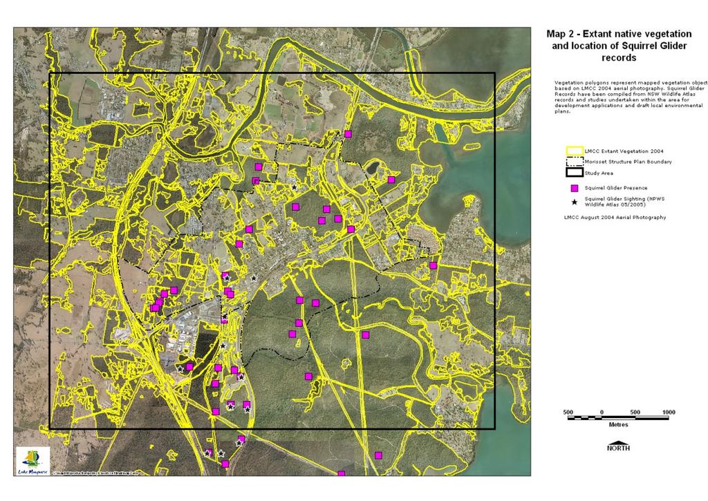
49
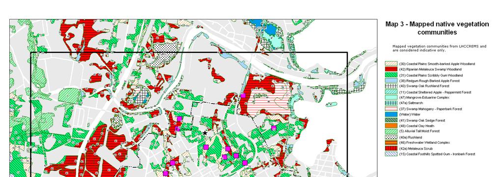
50 - 2 -
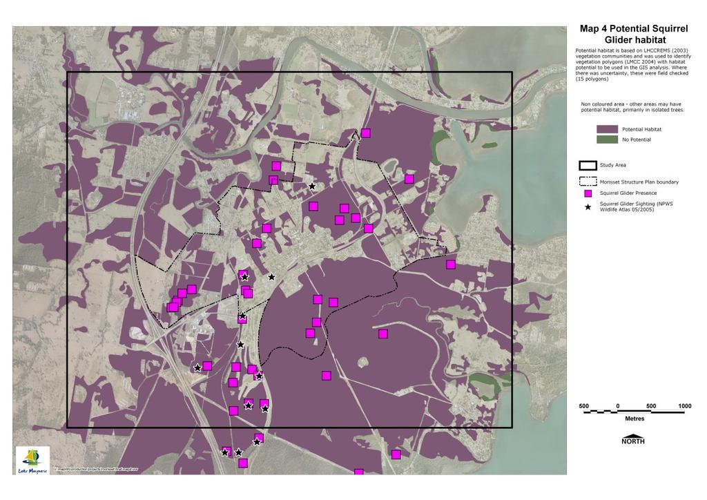
51 - 3 -
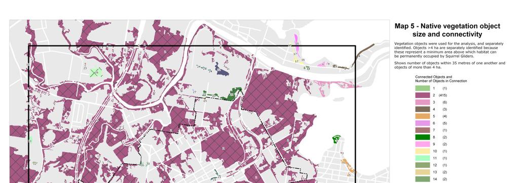
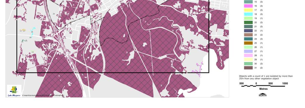
52 - 4 -
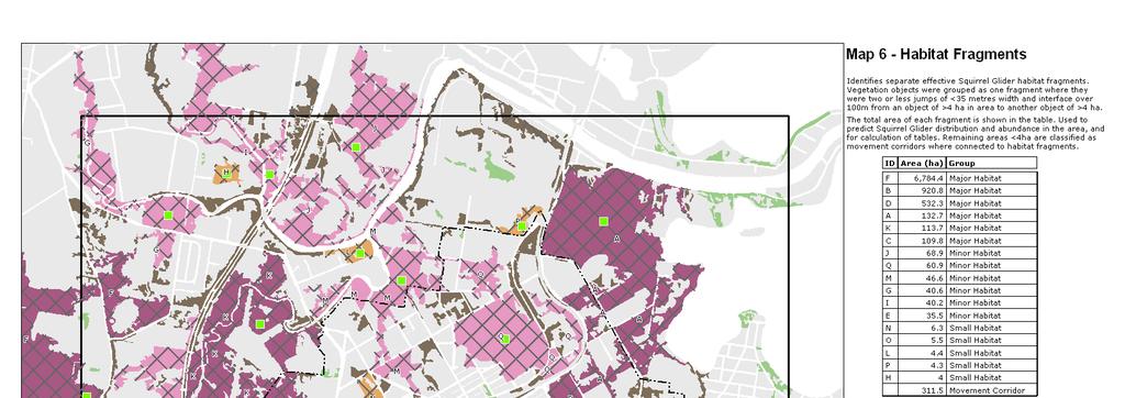
53 - 5 -
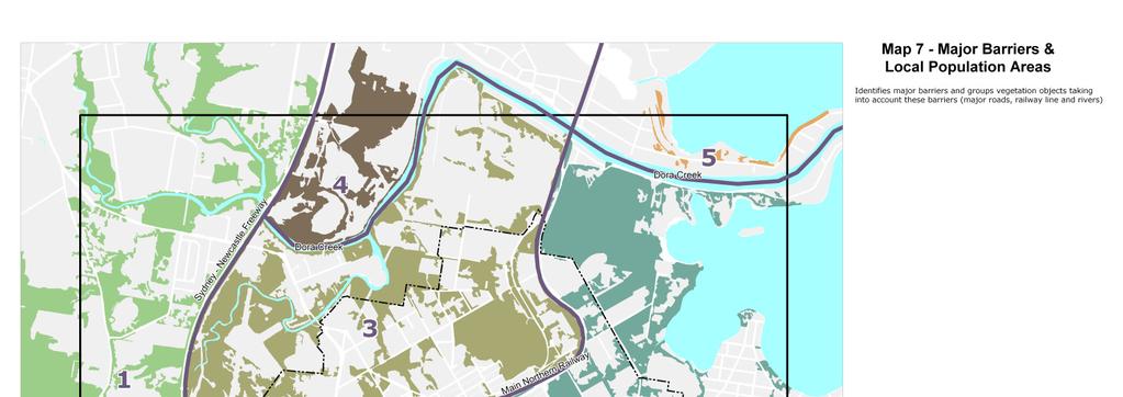
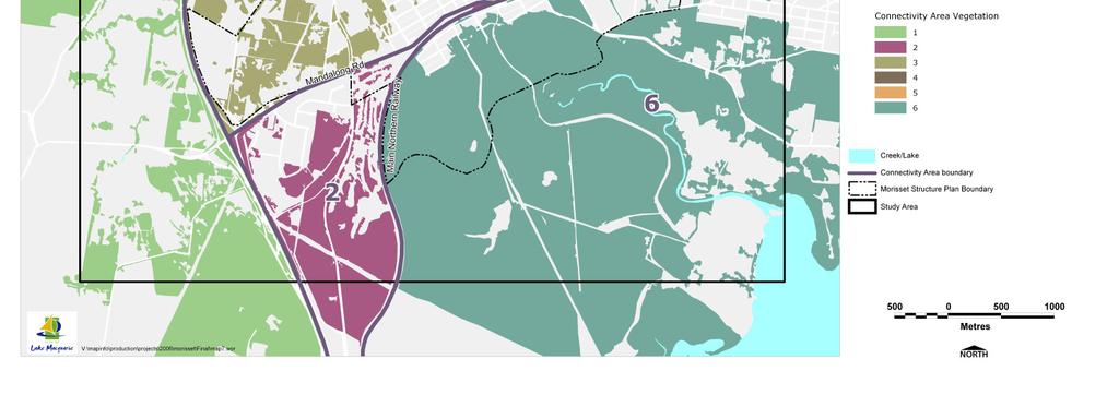
54 - 6 -
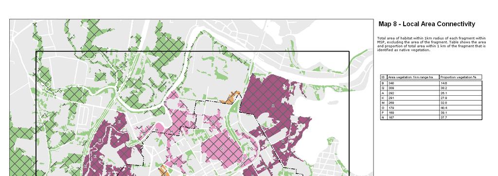
55 - 7 -
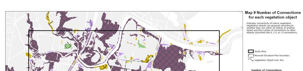

56 - 8 -
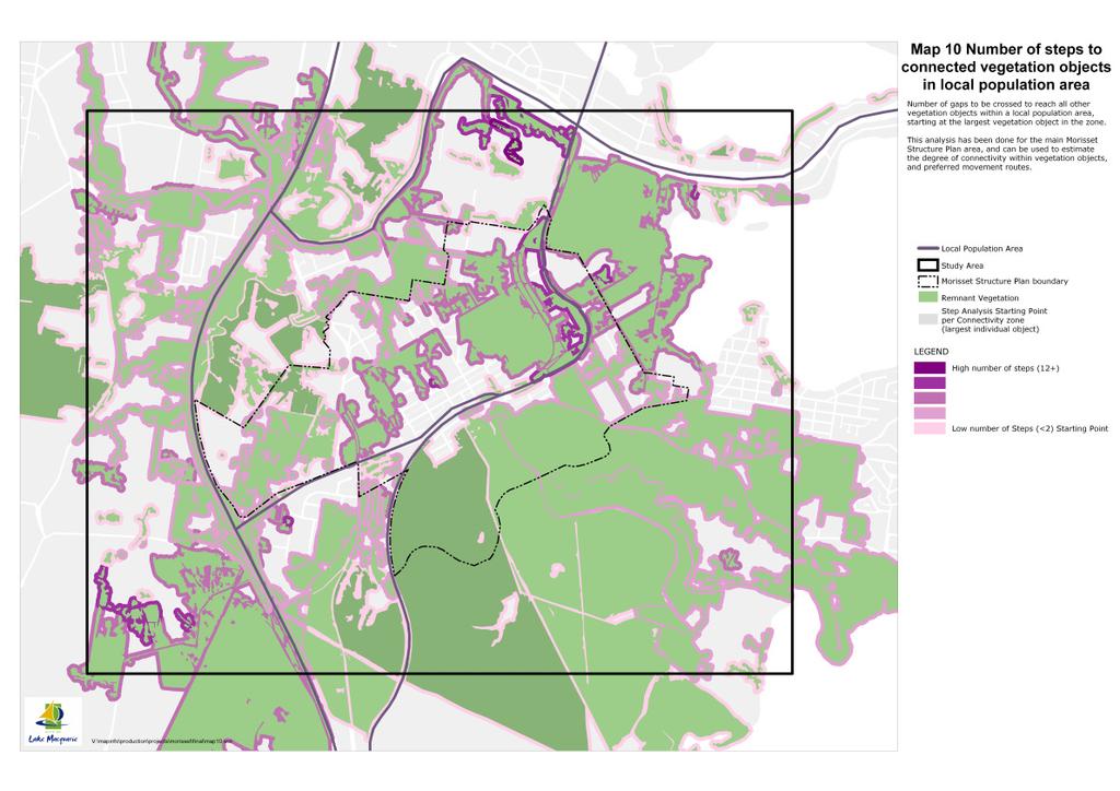
57 - 9 -
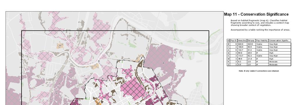
58 - 10 -
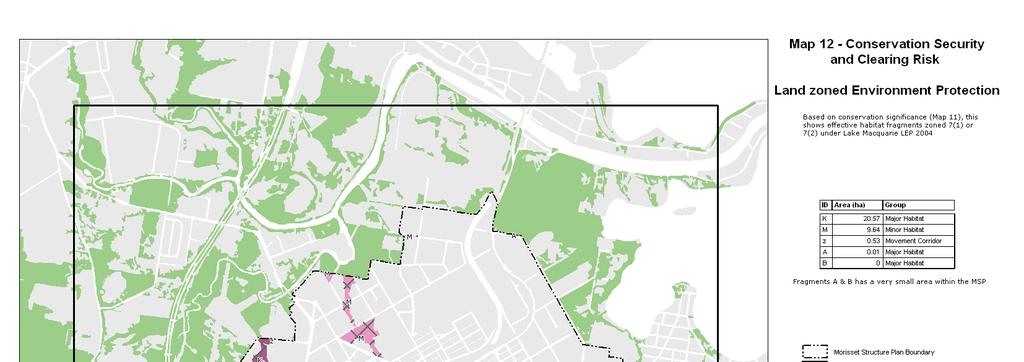
59 - 11 -
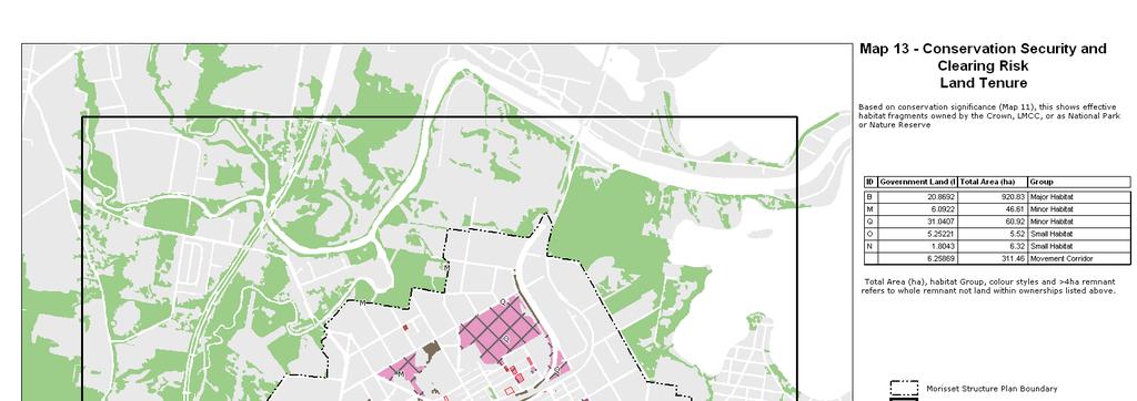
60 - 12 -

61 - 13 -
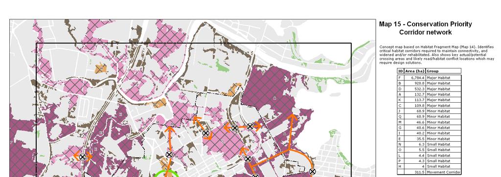
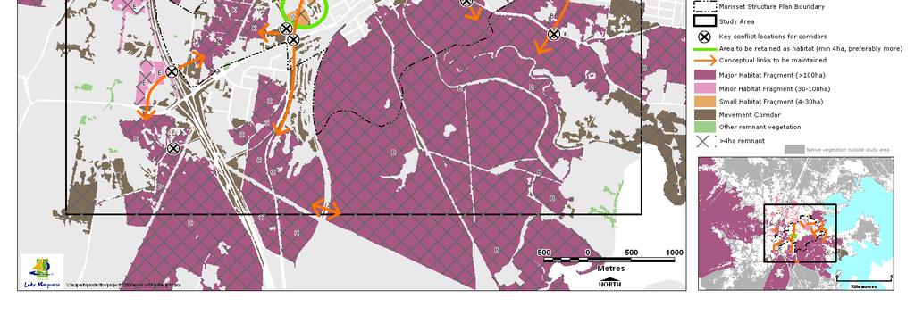
62 - 14 -
Lake Macquarie. Squirrel Glider. Planning and Management Guidelines 2015
 Lake Macquarie Squirrel Glider Planning and Management Guidelines 2015 Lake Macquarie City Council November 2015 Acknowledgements This report was prepared by Martin Fallding in collaboration with a wide
Labrador - Island Transmission Link Target Rare Plant Survey Locations
 27-28- Figure: 36 of 55 29-28- Figure: 37 of 55 29- Figure: 38 of 55 #* Figure: 39 of 55 30- - east side Figure: 40 of 55 31- Figure: 41 of 55 31- Figure: 42 of 55 32- - secondary Figure: 43 of 55 32-
Item 1 Ryhope Paper Subdivision
 Item 1 Ryhope Paper Subdivision Item 1 Ryhope Paper Subdivision Address (the site) 3, 5, 7,9 10-22, 24, 25, 28, 35-40, 42, 44, 46, 48 Charles Street, Ryhope 4, 6, 8, 10, 12, 14, 16, 18, 20, 22-28, 30,
Submission to NSW Koala Strategy Consultation Process. March 2017
 Submission to NSW Koala Strategy Consultation Process March 2017 Table of contents Opening 3 Response 3 Whole-of-government NSW koala strategy 3 State Environment Planning Policy (SEPP) 44 3 The draft
TOWN PLANNING SUBMISSION TO THE GREATER SYDNEY COMMISSION LANDS AT ARTARMON
 TOWN PLANNING SUBMISSION TO THE GREATER SYDNEY COMMISSION LANDS AT ARTARMON March 2017 TABLE OF CONTENTS 1.0 INTRODUCTION 3 2.0 THE SUBJECT SITE 4 3.0 STRATEGIC PLANNING CONTEXT 6 4.0 SUMMARY AND CONCLUSIONS
Kilometres. Blacktown. Penrith. Parramatta. Liverpool Bankstown. Campbelltown
 0 5 10 15 20 Kilometres Penrith Blacktown Parramatta Liverpool Bankstown Campbelltown accessibility outcomes Legend Outcomes targeted in Western Sydney are: public transport that is accessible throughout
FEASIBILITY CRITERIA
 This chapter describes the methodology and criteria used to evaluate the feasibility of developing trails throughout the study areas. Land availability, habitat sensitivity, roadway crossings and on-street
Visual and Sensory Aspect
 Updated All Wales LANDMAP Statistics 2017 Visual and Sensory Aspect Final Report for Natural Resources Wales February 2018 Tel: 029 2043 7841 Email: sw@whiteconsultants.co.uk Web: www.whiteconsultants.co.uk
Cheshire Ecology Ltd.
 Cheshire Ecology Ltd. What is an NVC Survey? 22 March 2014 1 Introduction A National Vegetation Classification (NVC) survey is a detailed botanical survey of a site. They are normally required for large
Classifications, Inventory and Level of Service
 Classifications, Inventory and Level of Service Section 3 Kenmore Park, Recreation and Open Space Plan 1 P a g e Classifications and Inventory Park Classifications Kenmore classifies its parks based upon
Recreation Opportunity Spectrum for River Management v
 Recreation Opportunity Spectrum for Management v. 120803 Introduction The following Recreation Opportunity Spectrum (ROS) characterizations and matrices mirror the presentation in the ROS Primer and Field
Koala and Greater Glider detection report, Ray s track coupes and , East Gippsland
 Koala and Greater Glider detection report, Ray s track coupes 905-501- 0011 and 905-501- 0010, East Gippsland Surveyors: Rena Gaborov and David Caldwell Report author: Rena Gaborov Report Date: 14/2/17
Report to: Greater Cambridge Partnership Joint Assembly 18 January A10 Foxton level crossing bypass and travel hub
 Report to: Greater Cambridge Partnership Joint Assembly 18 January 2018 Lead officer: Chris Tunstall GCP Director of Transport A10 Foxton level crossing bypass and travel hub 1. Purpose 1.1 The list of
The South Gippsland Koala. For over 60 years, the plantation industry has shared a unique relationship with the Strzelecki Koala. protection.
 The South Gippsland Koala For over 60 years, the plantation industry has shared a unique relationship with the Strzelecki Koala. protection harmony THE CO-EXISTENCE OF THE KOALA WITH THE PLANTATIONS co-existence
PSP 75 Lancefield Road. Northern Jacksons Creek Crossing Supplementary Information
 PSP 75 Lancefield Road Northern Jacksons Creek Crossing Supplementary Information September 2017 The northern crossing of Jacksons Creek proposed within the Lancefield Road PSP is a key part of the ultimate
NCC SUBMISSION ON EXPLANATION OF INTENDED EFFECT: STATE ENVIRONMENTAL PLANNING POLICY NO 44 KOALA HABITAT PROTECTION
 Director, Planning Frameworks NSW Department of Planning and Environment GPO Box 39 Sydney NSW 2001 16 December 2016 NCC SUBMISSION ON EXPLANATION OF INTENDED EFFECT: STATE ENVIRONMENTAL PLANNING POLICY
PROTECTED AREAS ZONE - POLICY
 PROTECTED AREAS ZONE - POLICY.1 Introduction The Protected Areas Zone applies to the land depicted on the Ruapehu District Plan Maps as: Amenity Policy Area. Protected Areas - Conservation. (c) Protected
White Mountain National Forest Saco Ranger District
 United States Department of Agriculture Forest Service White Mountain National Forest Saco Ranger District 33 Kancamagus Highway Conway, NH 03818 Comm: (603) 447-5448 TTY: (603) 447-3121 File Code: 1950
PREFACE. Service frequency; Hours of service; Service coverage; Passenger loading; Reliability, and Transit vs. auto travel time.
 PREFACE The Florida Department of Transportation (FDOT) has embarked upon a statewide evaluation of transit system performance. The outcome of this evaluation is a benchmark of transit performance that
Parrie Yalloak addition to the Grampians National Park
 Parrie Yalloak addition to the Grampians National Park Values Statement Land Stewardship & Biodiversity Department of Sustainability and Environment May 2005 This Values Statement has been written by James
5 Rail demand in Western Sydney
 5 Rail demand in Western Sydney About this chapter To better understand where new or enhanced rail services are needed, this chapter presents an overview of the existing and future demand on the rail network
HEATHROW COMMUNITY NOISE FORUM. Sunninghill flight path analysis report February 2016
 HEATHROW COMMUNITY NOISE FORUM Sunninghill flight path analysis report February 2016 1 Contents 1. Executive summary 2. Introduction 3. Evolution of traffic from 2005 to 2015 4. Easterly departures 5.
Conservation Partners for the National Reserve System Program: a Western NSW focus
 Conservation Partners for the National Reserve System Program: a Western NSW focus Cooper, N. 1, Webber, L. 2, Nicolson, K. 3 1 Department of Environment, Climate Change and Water NSW, PO Box 788 Broken
London Borough of Barnet Traffic & Development Design Team
 London Borough of Barnet Traffic & Development Design Team AERODROME ROAD PEDESTRIAN FACILITY AND BUS STOP INTRODUCTION FEASIBILITY REPORT Job Number: 60668 Doc Ref: S106/12-13/60668 Author: Manoj Kalair
Appendix F Public authorities responses
 Planning Proposal under sec 55 of the EP&A Act LEP Refinements Appendix F Public authorities responses Appendix F Public authorities responses Prior to public exhibition, consultation was made with the
LYNDHURST NEW URBAN DEVELOPMENT AREA STRUCTURE PLAN. Lyndhurst New Urban Development Area Structure Plan OUTCOMES AND PERFORMANCE STANDARDS
 APPENDIX 15.1-3 LYNDHURST NEW URBAN DEVELOPMENT AREA STRUCTURE PLAN Purpose of the Structure Plan Lyndhurst New Urban Development Area Structure Plan OUTCOMES AND PERFORMANCE STANDARDS LSP-P1 The District
HOW TO IMPROVE HIGH-FREQUENCY BUS SERVICE RELIABILITY THROUGH SCHEDULING
 HOW TO IMPROVE HIGH-FREQUENCY BUS SERVICE RELIABILITY THROUGH SCHEDULING Ms. Grace Fattouche Abstract This paper outlines a scheduling process for improving high-frequency bus service reliability based
Spatial Distribution and Characteristics of At-Risk Species in the Southeast U.S.
 Nicholas Institute for Environmental Policy Solutions Scoping Document Part 2 Exploratory Analysis of Characteristics and Trends of At-Risk Species in the Southeast U.S. Spatial Distribution and Characteristics
The Sunshine Coast is part of the global community and generates wealth through export, high-value industries and new investment.
 3.2 Strategic intent 3.2.1 Shaping growth an overview In 2031, the Sunshine Coast is renowned for its vibrant economy, ecological values, unique character and strong sense of community. It is Australia
Non-technical summary
 Introduction NTS1 NTS2 NTS3 Troika Developments Ltd (Troika) has submitted a planning application to Bournemouth Borough Council (BBC) for an extension of time to implement planning permission 7/2004/16450/G,
RE: Access Fund Comments on Yosemite National Park Wilderness Stewardship Plan, Preliminary Ideas and Concepts
 September 30, 2016 Superintendent Yosemite National Park Attn: Wilderness Stewardship Plan P.O. Box 577 Yosemite, CA 95389 RE: Access Fund Comments on Yosemite National Park Wilderness Stewardship Plan,
Aboriginal and Torres Strait Islander Life Expectancy and Mortality Trend Reporting
 Aboriginal and Torres Strait Islander Life Expectancy and Mortality Trend Reporting Technical Report December 2015 Amended May 2016 Authors: Clare Coleman, Nicola Fortune, Vanessa Lee, Kalinda Griffiths,
Chuckanut Ridge Fairhaven Highlands EIS Scoping Concerns
 Chuckanut Ridge Fairhaven Highlands EIS Scoping Concerns Coalition of Southside Neighborhoods CSN Comments for Fairhaven Highlands EIS Scope Hearing, Jan 16, 2008 1 Chuckanut Ridge Hilly Terrain: Potential
November 11, 2009 BY . Planning and Growth Management Department 110 Laurier Avenue West, 4 th Floor Ottawa, Ontario K1P 1J1. Dear Mr.
 November 11, 2009 Planning and Growth Management Department 110 Laurier Avenue West, 4 th Floor Ottawa, Ontario K1P 1J1 BY E-MAIL Attention: Mr. Don Herweyer Dear Mr. Herweyer: Reference: Abbott-Fernbank
EAST DON TRAIL ENVIRONMENTAL ASSESSMENT. Community Liaison Committee Meeting #3 July 15, :30 to 8:30 pm Flemingdon Park Library
 EAST DON TRAIL ENVIRONMENTAL ASSESSMENT Community Liaison Committee Meeting #3 July 15, 2013 6:30 to 8:30 pm Flemingdon Park Library Agenda 1. Welcome 2. Housekeeping and Updates a) Housekeeping b) CLC
HEATHROW COMMUNITY NOISE FORUM
 HEATHROW COMMUNITY NOISE FORUM 3Villages flight path analysis report January 216 1 Contents 1. Executive summary 2. Introduction 3. Evolution of traffic from 25 to 215 4. Easterly departures 5. Westerly
PROPOSED QUARRY FOOTPRINT PHASE 2 PHASE 3. PHASE 5 West. PHASE 5 East. PHASE 6 West. PHASE 6 East PHASE 7 PHASE 4 PHASE 1
 PHASE 4 \\Cd1220-f02\01609\active\2001 Active Projects\1100-1199\G1188\graphics\GIS\MXD\_Final Draft Sept 2008\MXD\Section_5\62601188_Fig5-0_ProposedQuarryFootprint_01Dec08_NJB.mxd PHASE 7 PHASE 5 West
Marchand Provincial Park. Management Plan
 Marchand Provincial Park Management Plan 2 Marchand Provincial Park Table of Contents 1. Introduction... 3 2. Park History... 3 3. Park Attributes... 4 3.1 Natural... 4 3.2 Recreational... 4 3.3 Additional
Cairns Airport Aircraft Noise Information Report
 Cairns Airport Aircraft Noise Information Report Quarter 4 2013 (October to December) 1 Version Control Version Number Detail Prepared by Date 1 - Environment February 2014 Airservices Australia. All rights
5 Demography and Economy
 5 Demography and Economy Demography People have probably lived on Great Barrier Island (Aotea) since the 13 th century. There are few written observations about the number of Maori settled here but these
PARKING CAPACITY REQUIREMENTS
 PARKING CAPACITY REQUIREMENTS Presented to: Antaramian Development Corporation 365 5 th Avenue South Naples, Florida 34102 CONTENTS Page INTRODUCTION... 1 BACKGROUND... 2 EXISTING PARKING CONDITIONS...
Other Principle Arterials Minor Arterial Major Collector Minor Collector Local
 CHAPTER 10 TRANSPORTATION Introduction The system of public roads in East Pikeland Township is decidedly rural in character. Since the 1984, the road network has remained much the same, with the addition
> Aircraft Noise. Bankstown Airport Master Plan 2004/05 > 96
 Bankstown Airport Master Plan 2004/05 > 96 24.1 Why Is Aircraft Noise Modelled? Modelling of the noise impact of aircraft operations has been undertaken as part of this MP. Such modelling is undertaken
Land Management Summary
 photo credit: ANGAIR Anglesea Heath Land Management Summary The Anglesea Heath (6,501 ha) was incorporated into the Great Otway National Park in January 2018. This provides an opportunity to consider the
sdrftsdfsdfsdfsdw Comment on the draft WA State Aviation Strategy
 sdrftsdfsdfsdfsdw Comment on the draft WA State Aviation Strategy 1 P a g e 2 P a g e Tourism Council WA Comment on the Draft WA State Aviation Strategy Introduction Tourism Council WA supports the overall
THRESHOLD GUIDELINES FOR AVALANCHE SAFETY MEASURES
 BRITISH COLUMBIA MINISTRY OF TRANSPORTATION & INFRASTRUCTURE AVALANCHE & WEATHER PROGRAMS THRESHOLD GUIDELINES FOR AVALANCHE SAFETY MEASURES British Columbia Ministry of Transportation & Infrastructure
Biosphere Reserves of India : Complete Study Notes
 Biosphere Reserves of India : Complete Study Notes Author : Oliveboard Date : April 7, 2017 Biosphere reserves of India form an important topic for the UPSC CSE preparation. This blog post covers all important
Southern African Biodiversity Status Assessment Report Biodiversity Asset: Bearded Vulture (Gypaetus barbatus)
") Southern African Biodiversity Status Assessment Report - 2017 Biodiversity Asset: Bearded Vulture (Gypaetus barbatus) Group Birds Common Name Bearded Vulture Scientific Name Gypaetus barbatus Assessment
Southern African Biodiversity Status Assessment Report - 2017 Biodiversity Asset: Bearded Vulture (Gypaetus barbatus) Group Birds Common Name Bearded Vulture Scientific Name Gypaetus barbatus Assessment
Project No Brent Cross, Cricklewood London, UK Phase 1A North RMA
 Project No. 431679 Brent Cross, Cricklewood London, UK Phase 1A North RMA River Overshadowing Impact Study For Waterman Energy, Environment & Design 18 th November 2014 431679 Report 2 Rel.3 1 of 23 431679rep2v3.docx
Queensland State Election Priorities 2017
 Queensland State Election Priorities 2017 Protecting, conserving and celebrating Queensland s environmental, built and cultural heritage. QUEENSLAND S HERITAGE MAKES A DIFFERENCE Environmental, built and
CONGESTION MONITORING THE NEW ZEALAND EXPERIENCE. By Mike Curran, Manager Strategic Policy, Transit New Zealand
 CONGESTION MONITORING THE NEW ZEALAND EXPERIENCE 26 th Australasian Transport Research Forum Wellington New Zealand 1-3 October 2003 By, Manager Strategic Policy, Transit New Zealand Abstract New Zealand
I508. Devonport Peninsula Precinct
 I508. Devonport Peninsula Precinct I508.1. Precinct description The purpose of the Devonport Peninsula precinct is to provide for the comprehensive residential development of the former Navy housing land
KOALA MANAGEMENT PLAN APPENDIX ENVIRONMENTAL IMPACT STATEMENT
 KOALA MANAGEMENT PLAN APPENDIX Y ENVIRONMENTAL IMPACT STATEMENT CEL12001 CEL12001 Prepared for Boral Resources (Qld) Pty Limited April 2013 Document Information Prepared for Boral Resources (Qld) Pty Limited
Appendix 8.D Water Vole and Otter Survey Report
 Appendix 8.D Water Vole and Otter Survey Report Entec UK Limited Entec UK Limited Water Vole and Otter Survey Report June 2009 Final Client Job Name Report title File reference E.ON Renewables Ltd Water
Keeping Wilderness Wild: Increasing Effectiveness With Limited Resources
 Keeping Wilderness Wild: Increasing Effectiveness With Limited Resources Linda Merigliano Bryan Smith Abstract Wilderness managers are forced to make increasingly difficult decisions about where to focus
Tourism Development Plan for Scotland Questionnaire
 Draft National Tourism Development Plan Public Consultation 2013 Tourism Development Plan for Scotland Questionnaire We would like your views on this Plan and, in particular, your comments on opportunities
MINIMUM REQUIREMENTS DECISION GUIDE WORKSHEETS
 ARTHUR CARHART NATIONAL WILDERNESS TRAINING CENTER MINIMUM REQUIREMENTS DECISION GUIDE WORKSHEETS Prescribed burning of islands within Okefenokee Wilderness Area.... except as necessary to meet minimum
Te Manahuna Consulting
 Assessment of the natural values at the proposed centre pivot irrigation site and surrounds on Ben Ohau Station, Mackenzie Basin, New Zealand August 2016 Abstract The natural values of the area proposed
CHAPTER 6 NOISE EXPOSURE
 CHAPTER 6 NOISE EXPOSURE FAA requires that the NEM submitted for review represent the aircraft noise exposure for the year of submittal (in this case 2008) and for a future year (2013 for OSUA). However,
An analysis of landscape connectivity of the Grassland Biome in Mpumalanga using graph theory. MSc Project Louise Fourie Supervisor: Prof. M.
 An analysis of landscape connectivity of the Grassland Biome in Mpumalanga using graph theory MSc Project Louise Fourie Supervisor: Prof. M. Rouget Introduction South African Grassland Biome Second largest
JOINT CORE STRATEGY FOR BROADLAND, NORWICH AND SOUTH NORFOLK EXAMINATION MATTER 3C EASTON/COSTESSEY
 Matter 3C Easton/Costessey Representor No. 8826 JOINT CORE STRATEGY FOR BROADLAND, NORWICH AND SOUTH NORFOLK EXAMINATION MATTER 3C EASTON/COSTESSEY SUBMISSION ON BEHALF OF TAYLOR WIMPEY DEVELOPMENTS AND
Produced by: Destination Research Sergi Jarques, Director
 Produced by: Destination Research Sergi Jarques, Director Economic Impact of Tourism North Norfolk District - 2016 Contents Page Summary Results 2 Contextual analysis 4 Volume of Tourism 7 Staying Visitors
Birch Point Provincial Park. Management Plan
 Birch Point Provincial Park Management Plan 2 Birch Point Provincial Park Table of Contents 1. Introduction... 3 2. Park History... 3 3. Park Attributes... 4 3.1 Natural... 4 3.2 Recreational... 4 4. Park
Produced by: Destination Research Sergi Jarques, Director
 Produced by: Destination Research Sergi Jarques, Director Economic Impact of Tourism Norfolk - 2016 Contents Page Summary Results 2 Contextual analysis 4 Volume of Tourism 7 Staying Visitors - Accommodation
SOUTH CAMBRIDGESHIRE DISTRICT COUNCIL. Executive Director / Senior Planning Policy Officer
 SOUTH CAMBRIDGESHIRE DISTRICT COUNCIL REPORT TO: Leader and Cabinet 8 May 2008 AUTHOR/S: Executive Director / Senior Planning Policy Officer SOUTH CAMBRIDGESHIRE DISTRICT COUNCIL S RESPONSE TO UTTLESFORD
Spatial Assessment for the revised Mpumalanga Biodiversity Expansion Strategy. Mervyn Lotter Scientific Services 8 June 2016
 Spatial Assessment for the revised Mpumalanga Biodiversity Expansion Strategy Mervyn Lotter Scientific Services 8 June 2016 Mpumalanga Protected Area Expansion Strategy (MPAES) Developed our first MPAES
Regulatory Committee
 Page 1 - Proposed Turning Movement Bans at South Gate Junction, Dorchester Regulatory Committee Date of Meeting 16 March 2017 Officer Subject of Report Executive Summary Andrew Martin Service Director
Response to the London Heathrow Airport Expansion Public Consultation
 Response to the London Heathrow Airport Expansion Public Consultation Summary This report sets out the response to the Heathrow Airport s consultation on airport expansion and airspace change. The consultation
The Design of Nature Reserves
 The Design of Nature Reserves Goals Maintenance of MVP s for targeted species Maintenance of intact communities Minimization of disease Considerations of reserve design 1. Disturbance regime Fire Insect
Watchorn Provincial Park. Management Plan
 Watchorn Provincial Park Management Plan 2 Watchorn Provincial Park Table of Contents 1. Introduction... 3 2. Park History... 3 3. Park Attributes... 3 3.1 Natural... 4 3.2 Recreational... 4 3.3 Additional
Order of the Minister of Environment #39, August 22, 2011 Tbilisi
 Registration Code 360050000.22.023.016080 Order of the Minister of Environment #39, August 22, 2011 Tbilisi On preparatory stages and procedure of the methodology for Elaborating structure, content and
This economic statement provides analysis with respect to land at Tarneit North, and has been prepared on behalf of Amex Corporation.
 Memorandum To: From: Amex Corporation c/- Greg Wood, Tract Consultants Matthew Lee Cc: Date: 12 June 2013 Subject: Economic Statement for Amex site Tarneit North PSP Dear Greg, This economic statement
SANBI PLANNING FORUM
 SANBI PLANNING FORUM SPATIAL PLANNING IN PROTECTED AREAS AND THEIR BUFFERS (South Africa) Ms Jayshree Govender, Dr Mike Knight and Mr Russell Smart 22 June 2017 OUTLINE 1) Introduction 2) Protected areas
A. CONCLUSIONS OF THE FGEIS
 Chapter 11: Traffic and Parking A. CONCLUSIONS OF THE FGEIS The FGEIS found that the Approved Plan will generate a substantial volume of vehicular and pedestrian activity, including an estimated 1,300
an engineering, safety, environmental, traffic and economic assessment of each option to inform a preferred route option choice; 3) Development and as
 Development and as") Page: 42 Infrastructure Services REPORT TO ABERDEENSHIRE COUNCIL COMMITTEE 26 APRIL 2018 A96 ABERDEEN TO INVERNESS DUALLING POSITION STATEMENT 1 Recommendations Aberdeenshire Council is recommended to:
Page: 42 Infrastructure Services REPORT TO ABERDEENSHIRE COUNCIL COMMITTEE 26 APRIL 2018 A96 ABERDEEN TO INVERNESS DUALLING POSITION STATEMENT 1 Recommendations Aberdeenshire Council is recommended to:
Proof of Concept Study for a National Database of Air Passenger Survey Data
 NATIONAL CENTER OF EXCELLENCE FOR AVIATION OPERATIONS RESEARCH University of California at Berkeley Development of a National Database of Air Passenger Survey Data Research Report Proof of Concept Study
Guidance for Complexity and Density Considerations - in the New Zealand Flight Information Region (NZZC FIR)
") Guidance for Complexity and Density Considerations - in the New Zealand Flight Information Region (NZZC FIR) Version 1.0 Director NSS 14 February 2018 Guidance for Complexity and Density Considerations
Guidance for Complexity and Density Considerations - in the New Zealand Flight Information Region (NZZC FIR) Version 1.0 Director NSS 14 February 2018 Guidance for Complexity and Density Considerations
Date: 11 th January, From: Plaistow & Ifold Parish Neighbourhood Plan - Steering Group. Plaistow & Ifold Parish Council
 Date: 11 th January, 2017 From: Plaistow & Ifold Parish Neighbourhood Plan - Steering Group To: Plaistow & Ifold Parish Council Re: Neighbourhood Plan Report to Parish Council Meeting 17 Jan 2017 The Steering
Supporting information to an application for preapplication 3 rd February 2017
 Development Services, West Lindsey District Council, Guildhall, Marshall s Yard, Gainsborough DN21 2NA Supporting information to an application for preapplication advice. 3 rd February 2017 Proposal for
PORT STEPHENS COUNCIL COMPREHENSIVE KOALA PLAN OF MANAGEMENT (CKPoM) Prepared by Port Stephens Council with the Australian Koala Foundation
 Prepared by Port Stephens Council with the Australian Koala Foundation") PORT STEPHENS COUNCIL COMPREHENSIVE KOALA PLAN OF MANAGEMENT (CKPoM) Prepared by Port Stephens Council with the Australian Koala Foundation June 2002 Port Stephens Council Comprehensive Koala Plan of Management
PORT STEPHENS COUNCIL COMPREHENSIVE KOALA PLAN OF MANAGEMENT (CKPoM) Prepared by Port Stephens Council with the Australian Koala Foundation June 2002 Port Stephens Council Comprehensive Koala Plan of Management
Produced by: Destination Research Sergi Jarques, Director
 Produced by: Destination Research Sergi Jarques, Director Economic Impact of Tourism Norfolk - 2017 Contents Page Summary Results 2 Contextual analysis 4 Volume of Tourism 7 Staying Visitors - Accommodation
Robson Valley Avalanche Tract Mapping Project
 Robson Valley Avalanche Tract Mapping Project Prepared for: Chris Ritchie Ministry of Water Land and Air Protection 325 1011 4th Avenue Prince George, BC. V2L3H9 and Dale Seip Ministry of Forests 1011
Aboriginal and Torres Strait Islander Life Expectancy and Mortality Trend Reporting to 2014
 Aboriginal and Torres Strait Islander Life Expectancy and Mortality Trend Reporting to 2014 Technical Report June 2016 Authors: Clare Coleman, Nicola Fortune, Vanessa Lee, Kalinda Griffiths, Richard Madden
4.0 Context for the Crossing Project
 4.0 Context for the Crossing Project This section provides background information about key features of the North Douglas Crossing project area, and opportunities and constraints. This information is important
NSW PRE-BUDGET STATEMENT FUTURE ECONOMY FUTURE JOBS
 2017-18 NSW PRE-BUDGET STATEMENT FUTURE ECONOMY FUTURE JOBS Executive Summary The 2017-18 NSW State Budget presents an opportunity for the NSW Government to future-proof the tourism and transport sectors.
PASSENGER SHIP SAFETY. Damage stability of cruise passenger ships: Monitoring and assessing risk from operation of watertight doors
 E MARITIME SAFETY COMMITTEE 93rd session Agenda item 6 MSC 93/6/9 11 March 2014 Original: ENGLISH PASSENGER SHIP SAFETY Damage stability of cruise passenger ships: Monitoring and assessing risk from operation
Energex Loganlea to Jimboomba Network Upgrade Response to Supplementary IAR. Closes 8 April Submission by
 Energex Loganlea to Jimboomba Network Upgrade Response to Supplementary IAR Closes 8 April 2010 Submission by Logan and Albert Conservation Association Prepared by Anne Page (BA Hons Dip Ed M Env Mgt)
WORKSHEET 1 Wilderness Qualities or Attributes Evaluating the Effects of Project Activities on Wilderness Attributes
 WORKSHEET 1 Wilderness Qualities or Attributes Evaluating the Effects of Project Activities on Wilderness Attributes Date: 3/7/2017 Roadless Area: Ruby South Description of Project Activity or Impact to
Squirrel Gliders: The Emblem of Informed Sustainability and Better Land Management
 Squirrel Gliders: The Emblem of Informed Sustainability and Better Land Management Ella Corbett, Kira Dawson, Britney Olsson, Zoe Trebilcock, Alan Sandstorm and Melissa Smith Trinity College, Albury-Wodonga
Case Study: 1. The Clarence River Catchment
 Case Study: 1. The Clarence River Catchment The NSW coastline is a great natural asset, making an enormous contribution to the economy. The resources of coastal catchments such as the Clarence River Catchment,
communication tower means a tower or structure built to support equipment used to transmit communication signals;
 Ontario Ministry of Natural Resources Subject Communication Tower Sites on Crown Land Compiled by - Branch Lands & Waters Section Land Management Policy PL 4.10.02 Replaces Directive Title Communication
Economic Development Sub- Committee
 Report title: Economic Development Sub- Committee Item No. Date of meeting: 24 November 2016 A47 Road Investment Strategy - update Responsible Chief Tom McCabe Executive Director, Community Officer: and
MANAGEMENT DIRECTION STATEMENT June, 1999
 Thompson River District MANAGEMENT DIRECTION STATEMENT June, 1999 for Roche Lake Provincial Park Ministry of Environment Lands and Parks BC Parks Division Table of Contents I. Introduction A. Setting
Arrangements for the delivery of minor highway maintenance services by Town and Parish Councils
 Arrangements for the delivery of minor highway maintenance services by Town and Parish Councils Cabinet Date of Meeting 8 March 2017 Officer Cllr Peter Finney, Cabinet Member for Environment, Infrastructure
PUBLIC CONSULTATION - THE PURPOSE
 PUBLIC CONSULTATION - THE PURPOSE ² To review the sites identified for housing development; ² To introduce new sites that have come forward since the last Public Consultation with potential for housing
A GUIDE TO MANITOBA PROTECTED AREAS & LANDS PROTECTION
 A GUIDE TO MANITOBA PROTECTED AREAS & LANDS PROTECTION Manitoba Wildands December 2008 Discussions about the establishment of protected lands need to be clear about the definition of protection. We will
ECORREGIONAL ASSESSMENT: EASTERN CORDILLERA REAL ORIENTAL PARAMOS AND MONTANE FORESTS
 ECORREGIONAL ASSESSMENT: EASTERN CORDILLERA REAL ORIENTAL PARAMOS AND MONTANE FORESTS The Nature Conservancy, EcoCiencia y Fundación AGUA. 2005. Evaluación Ecorregional de los Páramos y Bosques Montanos
DATE: January 19, WCA Governing Board. Johnathan Perisho, Project Manager. Mark Stanley, Executive Officer
 Item 14 DATE: January 19, 2017 TO: FROM: THROUGH: SUBJECT: WCA Governing Board Johnathan Perisho, Project Manager Mark Stanley, Executive Officer Item 14: Consideration of a resolution to accept an acquisition
Produced by: Destination Research Sergi Jarques, Director
 Produced by: Destination Research Sergi Jarques, Director Economic Impact of Tourism Oxfordshire - 2016 Economic Impact of Tourism Headline Figures Oxfordshire - 2016 number of trips (day & staying) 27,592,106
Appendix 8: Coding of Interchanges for PTSS
 FILE NOTE DATE 23 October 2012 AUTHOR SUBJECT Geoffrey Cornelis Appendix 8: Coding of Interchanges for PTSS 1. Introduction This notes details a proposed approach to improve the representation in WTSM