A Vision for Sutter s Landing Park Sacramento s Gateway to the American River Parkway
|
|
|
- Meryl Craig
- 5 years ago
- Views:
Transcription


1 A Vision for Sutter s Landing Park Sacramento s Gateway to the American River Parkway Created by Friends of Sutter s Landing Park

2 A Vision for Sutter s Landing Park Create a welcoming and safe place along the American River Parkway at historic Sutter s Landing Park in Midtown Sacramento where families and individuals can relax, recreate, and enjoy the beauty and wonders of nature, both now and for generations to come.


3 Nestled along the banks of the American River about a mile northeast of downtown Sacramento and less than three miles from California s State Capitol, Sutter s Landing Park is a natural treasure in the heart of Sacramento. It serves as a historic gateway to the 31.5-mile American River Parkway, which enjoys more than 8 million visitor days per year more than Yosemite National Park! With high population densities in the nearby adjacent neighborhoods of Midtown, Downtown, and East Sacramento, one of Sutter s Landing s best aspects is its accessibility to city residents. The Opportunity Sutter s Landing presents the opportunity of a nature park in the middle of the Central City, providing habitat for wildlife, as well as great access to trails along the American River for people. This 163-acre park currently offers a wide variety of other recreational opportunities, such as a covered skateboard park, a dog park, and the more recently added basketball and bocce ball courts. Sutter s Landing offers a unique opportunity to enhance the quality of life of residents today and for future generations. The park could become a legacy project for the City of Sacramento, enriching the livability of our city and making it a destination for families, nature-lovers, and outdoor recreation enthusiasts. There exists an opportunity to add to the current park by widening the corridor along the river that supports wildlife, by expanding access for people to enjoy this resource through additional nature trails, and by helping inspire children and their families through increasing opportunities to learn about science, nature, and the history of this important site.


4 Sutter s Landing Park is a riparian and upland corridor of the American River that serves as a buffer to the urban environment while providing vital habitat and recreation for wildlife and people. Location


5 History The Nisenan, or Southern Maidu, were the original inhabitants of this area. Traditionally, the Valley Nisenan lived along running water and traveled from place to place in boats made of tule reeds. They thrived by hunting, fishing, and gathering food from the area. In 1839, John Sutter and his men, after coming up the Sacramento River, landed at the northwest corner of what would eventually become Sutter s Landing Park. Shortly thereafter, Sutter established a permanent camp, and later built his fort at the current site of Sutter s Fort, the first settlement within the present city limits of Sacramento. Soil was taken from the Sutter s Landing area to build levees and elevate the city to prevent flooding. By the mid-1800 s, these excavations resulted in the formation of large pits. Over time, the pits were filled in with garbage generated by the expanding city. The site became known as the 28th Street Landfill. It became the city s primary landfill, growing to become the highest point in the City of Sacramento. After decades of use, the city first identified the landfill as the site of a future regional park in It was named Sutter s Landing Park by the City Council in 1989 and a Preliminary Master Plan for Sutter s Landing Park was adopted in The City of Sacramento s current approved Sutter s Landing Park Master Plan was adopted in October Since then, a number of substantial improvements have been made to the park.

6 The first inklings of a parkway along the American River date back almost a hundred years. As far back as 1915, the first possibility of a protected parkway along the American River was outlined by the eminent urban planner John Nolen. In the late 1940s, efforts for a parkway were again brought forward by Frederick Law Olmsted, Jr., the renowned planner and landscape architect and son of Frederick Law Olmsted, Sr., the designer of New York s Central Park. Olmsted emphasized the importance of some kind of protection for the river, including a parkway for the Sacramento River and its Tributaries. American River Parkway Plan Map of the 1915 American River Parkway Plan by John Nolen. the county s intent to preserve an open space greenbelt along the length of the American River in Sacramento County. The plan has been revised a number of times since its adoption, including most recently in The primary goal of the plan is, To provide, protect and enhance for public use a continuous open space greenbelt along the American River extending from the Sacramento River to Folsom Dam. The riverfront area of Sutter s Landing Park is included in the Woodlake Area Plan. Woodlake Area Plan Policy of the 2008 American River Parkway Plan aims to: Naturalist Elmer Aldrich, of Sacramento s River Park neighborhood, renewed efforts to create a parkway in the early 1950s. He envisioned a protected recreation area through the creation of the American River Parkway. He called for the public purchase of private land to form an integrated park system for public enjoyment. In 1962, the first American River Parkway Plan was adopted in concept by Sacramento County, declaring Protect, enhance, and expand native habitats that benefit fish and wildlife species including creation of seasonal wetland habitat, grassland restoration for raptor foraging habitat, and restoration of riparian and woodland habitat. It s time to further implement the vision of the American River Parkway Plan in and around Sutter s Landing Park. The Parkway also provides a naturalistic riparian corridor and open space greenbelt teeming with terrestrial and aquatic vegetation and wildlife. Beginning at the confluence with the Sacramento River at the northern edge of the City of Sacramento s downtown core, the Parkway provides a refreshing respite from the pressures of urban living.the American River Parkway truly is the Sacramento regional jewel American River Parkway Plan, p. 240

, including willing seller acquisition projects.")
7 Friends of Sutter s Landing Park Objectives Keep it Wild! Restore and enhance wildlife values at Sutter s Landing Park for the benefit of the wildlife and the enjoyment, education and well-being of all who visit. Restore and enhance wildlife values on the land surrounding Sutter s Landing Park by extending the boundaries of the American River Parkway to include additional land between the Capital City Freeway overpass and the 17th Street Bridge (on the southern side of the American River), including willing seller acquisition projects. Create a safe and direct connection between Sutter s Landing Park and the larger American River Parkway via a new pedestrian and bike trail connector. Enhance recreational opportunities that are compatible with wildlife values. Incorporate environmental, historical and cultural educational features and activities within the park. Evaluate strategic locations within Sutter s Landing Park which may be appropriate for green energy generation, as long as: 1. The construction and operation are non-disruptive to wildlife and habitat and are aesthetically appropriate for the American River Parkway, AND 2. A significant portion of the revenues generated through the lease of the park s land is directed toward wildlife habitat restoration within the park. Endeavor to make Sacramento s Sutter s Landing Park a model for connecting urban families and individuals with nature.


8 Diverse communities of plants and animals coexist within the natural areas at Sutter s Landing. The river attracts a wide variety of terrestrial and aquatic birds, mammals and other wildlife species. Riparian wetlands habitat provides food, water and shelter for a wide variety of birds, mammals, insects, fish and plants that make their home here. The American River is the dominant element of this ecosystem and, along with shoreline and upland habitats, form a connected and interdependent system. Submerged plants provide food and shelter for many creatures. River otters den and forage near the river s edge. Plant foods sustain turtles, crayfish and aquatic insect larvae. A cottonwood forest offers ideal nesting habitat for the threatened Swainson s Hawk, as well as many other birds, mammals, butterflies and other insects. Nearby upland areas provide foraging for many species as well as cover and nesting for other wildlife. Seasonal patterns in river level and flow fluctuations create changes throughout the year, presenting different habitat conditions for the plants and wildlife that rely on the area for sustenance and providing visitors with the ability to view an array of wildlife. The Ecosystem


, and northern harriers (California Species of Special Concern).")


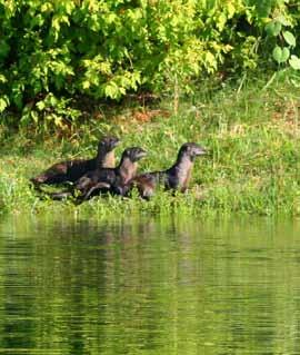
9 Wildlife The diversity of wildlife making a home at Sutter s Landing Park and nearby areas is surprising and impressive, especially considering how close it is to Downtown Sacramento. The area provides a home for wildlife that are at-risk, including Swainson s hawks (California Threatened species), white-tailed kites (California Fully Protected Animal), and northern harriers (California Species of Special Concern). snakes, fence lizards, skunks, ground squirrels, voles, and an occasional sea lion. Aquatic life includes clams, crawdads, catfish, salmon, steelhead trout, and other fish. Western pond turtles, the only native fresh-water turtle on the Pacific Coast, can be found here along with the introduced red-eared slider. Visitors can also see river otters, beavers, jackrabbits, cottontails, coyotes, raccoons, gopher Clockwise from top left: Blacktailed deer, birdwatchers, northern harrier, river otter, raccoon tracks; (center) red-tailed hawk with prey

, northern harriers (California Species of Special")


10 Birds Ranging from shorebirds and waterfowl to raptors, a wide range of birds can be spotted at Sutter s Landing, making it an excellent location for birding. Wood ducks, mallards, mergansers, cormorants, geese, pied-billed grebes, Swainson s hawks (California Threatened species), northern harriers (California Species of Special Concern), white-tailed kites (California Fully Protected Animal), red-tailed and red-shouldered hawks, barn and great horned owls, great blue heron, lesser and greater egrets, killdeer, western sandpipers, western meadowlarks, black phoebes, red-winged blackbirds, kestrels, ashthroated flycatchers, northern mockingbirds, belted kingfishers, northern flickers, cedar waxwings, warblers, woodpeckers, Anna s hummingbirds, yellow-billed magpies, sparrows, swallows, wrens, American goldfinches, mourning doves, robins, as well as Lazuli buntings can all be seen at various times of the year, depending on migration patterns. Clockwise from top left: Common egret, Swainson s hawks, birdwatchers, great blue heron; (center) spotted towhee


11 Plants A variety of plants make their home along the river at Sutter s Landing, including cottonwood trees, elderberry bushes, non-native fig trees, box elders, at least three species of willows, sedges, mushrooms, and many more. Previous disturbances have allowed the establishment of common non-native plants in areas. Some restoration work has been done through Friends of the River Banks, with more planned to bring back a number of the native plant species. Clockwise from top left: Wild grapes, honeybee pollinating native blackberry flowers, cattails, oak woodland


12 Butterflies, Dragonflies, and More Numerous insects can be found at Sutter s Landing Park, including at least 35 species of butterflies, dragonflies, ladybugs, bees and beetles. The valley elderberry longhorn beetle, a federally threatened species, can be found at Sutter s Landing. Both the western tiger swallowtail and pipevine swallowtail butterflies can be seen at Sutter s Landing. The pipevine swallowtail caterpillars feed only on Dutchman s pipe, a vine found along the American River. Other types of invertebrates, not as showy as the butterflies and dragonflies, are found in the water and on land. These species play a critical role in the food chain. Without them, the birds and mammals would not exist here. Clockwise from top left: Merganser family with crayfish for dinner, damselfly, clam, looking at critters, exploring the river


13 Sutter s Landing offers myriad opportunities for a variety of recreational activities for families and a place for children to experience nature. Some of the recreational opportunities include: Interpretive/hiking trails that provide opportunities to view wildlife in their natural habitats Boat launch for kayaks, canoes, and other nonmotorized boats Dog park Photography Bird-watching Cycling Walking and jogging Spiritual practices such as meditation and tai chi Yoga Bocce ball Basketball Skateboard park Outdoor stage Restoration work Nature walks Picnicking Recreational Opportunities Four photos above: Existing recreational facilities at Sutter s Landing Park include a large and a small dog park, bocce ball court, basketball court, and a skateboard park.


14 With its proximity to a large population base, Sutter s Landing presents a wonderful opportunity for a range of educational programs, on topics such as Native-American history, science, natural history, and living history, including programs for children that focus on the natural and cultural history of the American River Parkway. Sutter s Landing offers the space for educational programs that focus on the environment and on the importance of restoration, preservation, and conservation. Educational Opportunities


15 Restoration Opportunities Opportunities exist at Sutter s Landing for improving wildlife habitat through plantings of native species, thereby bringing back the area to a more natural state. Especially if additional land can be brought into the park, the wildlife corridor could be widened and restored and the riverside habitat could be increased, providing a wider and significantly more productive wildlife corridor for visitors to enjoy. Laurie Litman (3 bottom photos)

 Sacramento Area Creeks Council California Native Plant Society - Sacramento Valley Chapter Friends of Swainson s Hawk (FOSH) Save Our Sandhill Cranes (SOS Cranes)")
16 Friends and Supporters The following organizations, businesses, and individuals support the Friends of Sutter s Landing mission: B Street Theatre Boulevard Park Neighborhood Association Courtyard School East Sacramento Preservation Friends of the River Banks Friends of Grant Park Garcia Realty Joseph Cornell, author, Sharing Nature with Children Marshall School New Era Neighborhood Association McKinley East Sacramento Neighborhood Association Midtown Neighborhood Association Mindset Software New Era Community Garden Thai Basil Habitat 2020 Sacramento Audubon Society Save The American River Association (SARA) Sacramento Area Creeks Council California Native Plant Society - Sacramento Valley Chapter Friends of Swainson s Hawk (FOSH) Save Our Sandhill Cranes (SOS Cranes) Environmental Council of Sacramento (ECOS) One of our partner organizations, Friends of the River Banks (FORB), offers free nature walks and activities on the second Saturday morning of most months. Recent walks include an expert-guided talk about subjects such as geology, mushrooms, birds, native plants, and dragonflies. For more information, visit


17 Sutter s Landing Park is a place where people can bask in the natural world within the hustle and bustle of our urban core. It is a place where children can play and absorb themselves in nature. It offers wildlife a home within our urban midst and a chance for urban residents to connect with nature. The opportunity is there to expand upon. Conclusion Cecile Martin


18 Keep It Wild! There s a stretch along the American River Where nature s beauty will set you free, There s an oasis in the heart of Sacramento, A place our children love to be. Let s keep it wild! We invite our community leaders to join us In restoring wildlife values as we strive To enhance Sacramento s urban oasis So that all life at Sutter s Landing Park can thrive. Let s keep it wild! It is time to connect with the river, As the honorable Nisenan people of the Maidu tribe would do, It is a constant source of wisdom, And of lessons, old and new. Let s keep it wild! Now imagine our great grandchildren Playing along these historical shores, Laughing with the river otters, Watching the spectacular Swainson s hawks soar. Let s keep it wild!


19 Contact Friends of Sutter s Landing Park Laurie Litman ; llitman@pacbell.net Lori Ward ; grisward@sbcglobal.net All photos in this publication Robert Sewell unless otherwise noted
A Vision for Sutter s Landing Park Sacramento s Gateway to the American River Parkway
 A Vision for Sutter s Landing Park Sacramento s Gateway to the American River Parkway Created by Friends of Sutter s Landing Park http://www.sutterslandingpark.org A Vision for Sutter s Landing Park Create
Niagara Natural Heritage Park
 A Future Proposal For the Niagara-on-the-Lake DND Lands....... Parks Canada Lakeshore Road Property 1 May, 2016 The Harmony Residents Group We are proposing a Natural Heritage Park be established on the
Flow Stand Up Paddle Board Parkway Plan Analysis
 Regional Parks Department Jeffrey R. Leatherman, Director County of Sacramento Divisions Administration Golf Leisure Services Maintenance Rangers Therapeutic Recreation Services Flow Stand Up Paddle Board
The Sand Ridge - Tulare Lake Conservation Report proposes the following recommendations:
 Introduction Creighton Ranch. Pixley National Wildlife Refuge. Allensworth State Historic Park. Sand Ridge. Deer Creek. Located in the Tulare Lake Basin, the Sand-Ridge - Tulare Lake Planning Area features
MCARTHUR SWAMP PLANNING UNIT Pit-McCloud River Watershed
 Existing Conditions & Uses Overview Spring-fed lake and rivers; valuable grazing lands and important waterfowl area Planning unit provides the only public access to Ahjumawi Lava Springs State Park 7,596
Wilds. Headwaters. Lakes. Oxbows. Falls
 56 5 4 3 Wilds Headwaters Lakes Oxbows Falls 57 Zones It could be said the on-the-ground essence of this master plan appears within the next 6 pages of this report. As we learned in the preceding Cultural
IOWA ORNITHOLOGISTS' UNION - Birding Sites in Dallas County
 IOWA ORNITHOLOGISTS' UNION - Birding Sites in Dallas County Printed on 7/19/2018 Beaver Bottoms Wetland (restricted) (Important Bird Area) GPS Coordinates:, Ownership: Private (see directions for access)
Our Mission. Discover the many states of California. Chino Hills State Park 1879 Jackson Street Riverside, Ca (951)
") Chino Hills State Park Our Mission The mission of the California Department of Parks and Recreation is to provide for the health, inspiration and education of the people of California by helping to preserve
Chino Hills State Park Our Mission The mission of the California Department of Parks and Recreation is to provide for the health, inspiration and education of the people of California by helping to preserve
IOWA ORNITHOLOGISTS' UNION - Birding Sites in Cerro Gordo County
 IOWA ORNITHOLOGISTS' UNION - Birding Sites in Cerro Gordo County Printed on 11/17/2018 Blue-wing Marsh GPS Coordinates: 43.0834956379463,-93.4430980682373 Pure natural area primarily used for hunting.
ANAGEMENT. LAN November, 1996
 M ANAGEMENT P LAN November, 1996 for Paul Lake Provincial Park Ministry of Environment, Lands and Parks BC Parks Department Paul Lake Provincial Park M ANAGEMENT P LAN Prepared by BC Parks Kamloops Area
Wetlands Reservoirs of Biodiversity. Billy McCord, SCDNR
 Wetlands Reservoirs of Biodiversity Billy McCord, SCDNR Estuaries Tidal Deepwater Intertidal Salt Marsh Tidal Riverine Fresh & Brackish Deepwater Tidal Emergent Marsh Freshwater Riverine Seasonally Flooded
Pinellas County Environmental Lands
 Pinellas County Environmental Lands In addition to traditional parks and recreation facilities, Pinellas County owns and manages a system of environmental lands that provides specialized resource-based
Rouge National Park. Opportunities and Challenges
 Rouge National Park Opportunities and Challenges January 2013 Rouge Park Finch Meander Rouge Beach at Lake Ontario Toronto GLWQA Area of Concern Rouge National Park Nationally Significant First Nation
2.0 PARK VISION AND ROLES
 2.0 PARK VISION AND ROLES 2.1 Significance in the Protected Area System Marble Range and Edge Hills provincial parks protect 6.8% of the Pavillion Ranges Ecosection, which is located in the Southern Interior
Maya s Creek Crossing Hwy 17 N acres $185,000 Fort Davis, Texas
 Maya s Creek Crossing Hwy 17 N 14.98 acres $185,000 Fort Davis, Texas James King, Agent Office 432-426-2024 Cell 432-386-2821 James@KingLandWater.com King Land & Water LLC P.O. Box 109, 600 State Street,
Animals of Mt. Diablo
 Animals of Mt. Diablo This is one suggestion for a one-hour program. Docents are free to present the program in any way they think is effective, especially since you have such a wide variety of animals
BROUGHTON ARCHIPELAGO PROVINCIAL PARK
 BROUGHTON ARCHIPELAGO PROVINCIAL PARK PURPOSE STATEMENT AND ZONING PLAN March 2003 BROUGHTON ARCHIPELAGO PROVINCIAL PARK Purpose Statement and Zoning Plan Primary Role The primary role is to contribute
STORNETTA BROTHERS COASTAL RANCH
 STORNETTA BROTHERS COASTAL RANCH Location: Surrounding Point Arena Lighthouse and immediately south of Manchester State Park Mendocino Co., CA Acres: 1,860 Resources: Over two miles of Pacific Ocean coastline
Onondaga Lake Loop the Lake Trail
 Onondaga Lake Loop the Lake Trail A N A N A LY S I S Created by Lindsay Speer December 2011 The Issue: Healing Relationship with Onondaga Lake Prior proposals from Onondaga County, the U.S. Army Corps
Tambopata Eco Lodge Programs
 Tambopata Eco Lodge Programs Rainforest Experience After your flight to the jungle town of Puerto Maldonado you will be met by our staff, who will escort you during the fascinating three-hour boat trip
Morgan Estates. Lassen County, CA. Proudly Offered By
 Morgan Estates Lassen County, CA Proudly Offered By 707 Merchant Street, Suite 100, Vacaville, Ca 95688 (707) 455-4444 Office (707) 455-0455 Fax info@caoutdoorproperties.com Introduction Looking North
Terrestrial Protected Area Nomination: Central Mangrove Wetland South-West, Grand Cayman
 Terrestrial Protected Area Nomination: Central Mangrove Wetland South-West, Grand Cayman The attached nomination, proposing that a parcel of land in the Central Mangrove Wetland be made a Protected Area
FEASIBILITY CRITERIA
 This chapter describes the methodology and criteria used to evaluate the feasibility of developing trails throughout the study areas. Land availability, habitat sensitivity, roadway crossings and on-street
Segment 2: La Crescent to Miller s Corner
 goal of the USFWS refuges is to conserve, protect and enhance fish, wildlife and plants and their habitats for the continuing benefit of the American people. Refuge lands are used largely for fishing,
DOYLE SPRINGS PLANNING UNIT Kern-Tule River Watershed
 Existing Conditions & Uses Overview Consists of a mostly forested parcel with small hydropower developments and part of a private recreation cabin development, along with two small transmission line corridor
Mills Pecos River Ranch 7800 Acres Val Verde County, Texas Situated along both sides of the Pecos River
 Mills Pecos River Ranch 7800 Acres Val Verde County, Texas Situated along both sides of the Pecos River James King, Agent Office 432-426-2024 Cell 432-386-2821 James@KingLandWater.com King Land & Water
San Antonio Channel Improvement Project MISSION REACH ECOSYSTEM RESTORATION PROJECT. Welcome Assistant Secretary (CW) Jo-Ellen Darcy December 8, 2009
 Jo-Ellen Darcy December 8, 2009") San Antonio Channel Improvement Project MISSION REACH ECOSYSTEM RESTORATION PROJECT Welcome Assistant Secretary (CW) Jo-Ellen Darcy December 8, 2009 1 Presentation Overview Review history of San Antonio
San Antonio Channel Improvement Project MISSION REACH ECOSYSTEM RESTORATION PROJECT Welcome Assistant Secretary (CW) Jo-Ellen Darcy December 8, 2009 1 Presentation Overview Review history of San Antonio
A CASE FOR COMPLETING THE JORDAN RIVER PARKWAY: A
 A CASE FOR COMPLETING THE JORDAN RIVER PARKWAY: A safe crossing at 9000 South and 850 West Proposed 9000 South Underpass Parkway Timeline Parkway, Trail, and Tourism Facts Blueprint Jordan River 1971 1973
Level IV Ecoregions of the Northeast Glacial Lakes Watershed Project Area
 Level IV Ecoregions of the Northeast Glacial Lakes Watershed Project Area Ecoregions are areas having similar ecosystems and environmental resources including geology, physiography, vegetation, climate,
Whitemouth Falls Provincial Park. Draft Management Plan
 Whitemouth Falls Provincial Park Draft Management Plan Whitemouth Falls Provincial Park Draft Management Plan Table of Contents 1. Introduction... 3 2. Park History... 3 3. Park Attributes... 4 3.1 Natural...
AGENDA ITEM 5 D WAKULLA ENVIRONMENTAL INSTITUTE (WEI) TRAIL FEASIBILITY STUDY
 TRAIL FEASIBILITY STUDY") March 19, 2018 AGENDA ITEM 5 D WAKULLA ENVIRONMENTAL INSTITUTE (WEI) TRAIL FEASIBILITY STUDY TYPE OF ITEM: Action STATEMENT OF ISSUE The Wakulla Environmental Institute (WEI) Trail is one of several trails
March 19, 2018 AGENDA ITEM 5 D WAKULLA ENVIRONMENTAL INSTITUTE (WEI) TRAIL FEASIBILITY STUDY TYPE OF ITEM: Action STATEMENT OF ISSUE The Wakulla Environmental Institute (WEI) Trail is one of several trails
Merida Ranch 270+/- Acres Hopkins County, Texas $1,076, ($3,995/acre)
") 270+/- Acres Hopkins County, Texas $1,076,704.43 ($3,995/acre) (214) 361-9191 HRCranch.com Hopkins County, Texas 270+/- Acres LOCATION: is located near Sulphur Bluff, Texas, in northeastern Hopkins County.
270+/- Acres Hopkins County, Texas $1,076,704.43 ($3,995/acre) (214) 361-9191 HRCranch.com Hopkins County, Texas 270+/- Acres LOCATION: is located near Sulphur Bluff, Texas, in northeastern Hopkins County.
A Vision for South Skunk River and Chichaqua Bottoms Greenbelt
 A Vision for South Skunk River and Chichaqua Bottoms Greenbelt Photo: Jim Pease Chichaqua Bottoms Booklet 7 of 8 Greater Des Moines Water Trails and Greenways 1 2016 Table of Contents Booklet 1: Water
Comanche National Grassland, Timpas Unit
 Comanche National Grassland, Timpas Unit Heritage Resources More than 540 sites are eligible for listing on the National Register of Historic Places (NRHP) by Forest Service staff and/or the Colorado State
Heartland Country Real Estate
 Heartland Country Heartland Real Estate Country Real Estate is a full-service real estate agency based in the heart of s famous Sandhills region. In addition to being the home of top-quality cattle ranches,
2018 Summer Day Camps
 2018 Summer Day Camps Your children will enjoy a wild summer at Fontenelle Forest, just minutes from downtown Omaha. @FONTENELLEFOREST @FONTENELLE4EST FONTENELLEFOREST.ORG @FONTENELLEFOREST SUMMER CAMPS
Hazardous Wildlife Management
 Hazardous Wildlife Management ACI-NA Joint Session Technical & Operations Committee Public Safety & Security Committee Emily Underhill, P.E. Division Director - Development March 16, 2009 Who We Are The
2. Goals and Policies. The following are the adopted Parks and Trails Goals for Stillwater Township:
 D. PARKS AND TRAILS 1. Introduction Stillwater Township s population is relatively low, with most residents living on rural residences on large lots. The need for active park space has been minimal in
Southwest Quadrant Distinctive Features
 SOUTHWEST QUADRANT Southwest Quadrant Distinctive Features LAND USE The 31.17 square mile Southwest Quadrant includes all the area within the planning area west of I-5 and south of the Sacramento River.
Greening Project Status Report: Grand Canyon National Park
 Greening Project Status Report: Grand Canyon National Park Prepared for the Federal Energy Management Program U.S. Department of Energy February 2001 iii Contents Page 1. Introduction... 1 2. Context of
Cuyahoga Valley National Park Ohio
 Cuyahoga Valley National Park Ohio Brandywine Falls The Ledges The Beaver Marsh Temperate Deciduous Forest How To Get There... Located between Cleveland & Akron, Ohio Cuyahoga Valley National Park can
Preparing Baseline Documentation for your Protected Lands
 Preparing Baseline Documentation for your Protected Lands December 7, 2013 William Hall Free Library Cranston, RI Carol Lynn Trocki, Conservation Biologist Sponsored by Rhode Island Land Trust Council
Welcome to the future of Terwillegar Park a Unique Natural Park
 Welcome to the future of Terwillegar Park a Unique Natural Park 1 Introduction The Terwillegar Park Concept Plan study will develop an overall concept plan, management objectives and development guidelines
Discover. Ashhurst Domain. Nature s Playground
 Discover Ashhurst Domain Nature s Playground Discover Step back into New Zealand, Aotearoa, of generations long gone. Discover lush natural surrounds echoing with rich birdsong in one of the Manawatu s
Part Three : COMMUNITY PLAN AREAS AND SPECIAL STUDY AREAS SACRAMENTO 2030 GENERAL PLAN. Introduction
 Special study Areas Part Three : COMMUNITY PLAN AREAS AND SPECIAL STUDY AREAS SACRAMENTO 2030 GENERAL PLAN Introduction Beyond the boundaries of the 2030 General Plan, the City has defined Special Study
MANAGEMENT DIRECTION STATEMENT June, 1999
 Thompson River District MANAGEMENT DIRECTION STATEMENT June, 1999 for Clearwater River Corridor (Addition to Wells Gray Park) Ministry of Environment Lands and Parks BC Parks Division ii Table of Contents
BROCHURE. APPLE HILL WOODS 118 +/- Acres Camino, California. Presented by Jim Copeland
 BROCHURE APPLE HILL WOODS 118 +/- Acres Camino, California Presented by Jim Copeland 1 The Property This 118 acre is a rare gem in the Sierra Nevada foothills. Covered with lush forestland and scattered
Eagle Pinon Ranch. 2,963 +/- acres, Hudspeth County
 Eagle Pinon Ranch 2,963 +/- acres, Hudspeth County Eagle Piñon Ranch 2963 acres Hudspeth County, Texas Location The Eagles are part of a chain of sky island mountains that stretch from New Mexico through
Map 1.1 Wenatchee Watershed Land Ownership
 Map 1.1 Wenatchee Watershed Land Ownership Map 1.1 Wenatchee Watershed Land Ownership The Wenatchee watershed lies in the heart of Washington state in Chelan County. Just larger than the state of Rhode
OPG, Nuclear 2
 B iodiversity Assessment Building a Biodiversity Management Plan November 24, 2011 OPG, Nuclear 2 Biodiversity Assessment What habitat, or your site? potential habitat, is available on What species of
LOVE FIELD ENVIRONMENTAL ADVISORY COMMITTEE QUARTERLY REPORT
 LOVE FIELD ENVIRONMENTAL ADVISORY COMMITTEE QUARTERLY REPORT October 19, 2017 Dallas Love Field 7555 Lemmon Ave Conference Room 103 AGENDA Introductions Wildlife Hazard Working Group Bachman Lake USTW
Silver Lake Park An Environmental Jewel for the Citizens of Prince William County
 Silver Lake Park An Environmental Jewel for the Citizens of Prince William County The Prince William Park Authority Mission Statement states: The Prince William County Park Authority will create quality
Field Guide. Nature Nearby. Traverse City
 Field Guide Nature Nearby Traverse City FEATURED PROPERTIES 1 DEEPWATER POINT NATURAL AREA 2 HICKORY MEADOWS NATURAL AREA KALKASKA 3 MAPLE BAY NATURAL AREA E as t A rm G r a n d Tr a v er s e B ay 4 PELIZZARI
The Chippewas of Georgina Island First Nation At A Glimpse
 Located in Lake Simcoe approximately100 km north of the Greater Toronto Area (GTA) in Ontario Canada. Consisting of 3 separate Islands, Georgina, Snake and Fox with 2 mainland access points.. Georgina
Northeast Quadrant Distinctive Features
 NORTHEAST QUADRANT Northeast Quadrant Distinctive Features LAND USE The Northeast Quadrant includes all the area within the planning area that is east of Interstate 5 and to the north of State Route 44.
3.0 EXISTING PARK & RECREATION SPACE
 3.0 EXISTING PARK & RECREATION SPACE TOWN PARK & RECREATION SPACE An inventory of current parks and recreation area in the Town of Cedarburg is shown in Table 3. These areas total roughly 381.89 acres.
Summary of prescribed fires in Prince Albert National Park 2015
 Summary of prescribed fires in Prince Albert National Park 2015 Prince Albert National Park conducted four controlled fires in spring 2015, plus an additional fire in October. Fuel Management for Hazard
Human Habitat. Cachuma Lake DISCOVERY BOOK Cachuma Lake Discovery Book V1, Santa Barbara County Parks
 Human Habitat Cachuma Lake DISCOVERY BOOK.0 The Human Habitat People live in houses and buildings to be comfortable and safe. We live together in towns and cities. We build roads to drive our cars from
Parks & Recreation Areas Program
 PARKS & RECREATION Parks & Recreation Areas Program As part of its mission to conserve and protect natural resources, the Upper Big Blue Natural Resources District (NRD) has been involved in several large-scale
The Narrows Waterfront Park A Crown Jewel for Southern Brooklyn
 The Narrows Waterfront Park A Crown Jewel for Southern Brooklyn In New York, the unquestioned popularity of urban spaces such as Riverside Park, the High Line, Brooklyn Bridge Park and others has demonstrated
Birch Point Provincial Park. Management Plan
 Birch Point Provincial Park Management Plan 2 Birch Point Provincial Park Table of Contents 1. Introduction... 3 2. Park History... 3 3. Park Attributes... 4 3.1 Natural... 4 3.2 Recreational... 4 4. Park
A THRIVING ENVIRONMENTAL AND RECREATIONAL PRECINCT IN OUR SOUTHERN SUBURBS
 A THRIVING ENVIRONMENTAL AND RECREATIONAL PRECINCT IN OUR SOUTHERN SUBURBS A STRONG PLAN FOR REAL CHANGE 1 We re ready. Over the last four years, we ve been working hard developing our vision for the future
Double Bar Z Ranch 8,690 ± California. Mariposa County Exclusive Agents Allen Alsobrook Jim Watson. Sierra Foothills. La Grange
 Double Bar Z Ranch 8,690 ± California. Mariposa County Exclusive Agents Allen Alsobrook Jim Watson Sierra Foothills. La Grange The Double Bar Z Ranch is a spectacular working cattle ranch. It has been
Swan Valley Farms. 523 acres for sale in Bonneville County, ID JIMMY ROUMANIS. JOHN STARR
 Swan Valley Farms JOHN STARR 208 472 2838 john.starr@colliers.com 523 acres for sale in Bonneville County, ID JIMMY ROUMANIS 208 472 2840 jimmy.roumanis@colliers.com Swan Valley Farms- 523 acres for sale
Dungeness Recreation Area County Park Master Plan
 Dungeness Recreation Area County Park Public Outreach Meeting October 10, 2007 Project Overview USFWS Site Dungeness Recreation Area County Park Meeting Objectives: Re-Introduce project; provide status
Lake Myra County Park. Wake County, North Carolina Community Forum #2 June 12, 2008
 Lake Myra County Park Wake County, North Carolina Community Forum #2 June 12, 2008 Welcome and Introduction Meeting Agenda Welcome Introductions of Project Team Master Plan Process Community Forum #1 Updates
Lake Acreage Mcleese Lake, BC
 Lake Acreage Mcleese Lake, BC Jason Zroback jason@landquest.com 1 (604) 414-5577 Jamie Zroback jamie@landquest.com 1 (604) 483-1605 The Source for Oceanfront, Lakefront, Islands, Ranches, Resorts & Land
Everett Riverwalk Life style explore
 Life style explore Project Overview The 217-acre Everett Riverfront redevelopment is visible from I-5 with traffic counts charted at 170,000+ vehicles per day with direct freeway access from 4-way interchange.
Roduner Ranch FOR SALE. 5,878± Acres Potential Development Land. Merced County, California. Offices Serving The Central Valley
 FOR SALE 5,878± Acres Potential Development Land Merced County, California Offices Serving The Central Valley F R E S N O V I S A L I A B A K E R S F I E L D 7480 N. Palm Ave, Ste 101 3447 S. Demaree Street
2.0 Physical Characteristics
 _ 2.0 Physical Characteristics 2.1 Existing Land Use for the Project The site is comprised of approximately 114 acres bounded by Highway 101 to the north, the existing town of Los Alamos to the east, State
Wool Ranch 20 Acres 20 +/- acres Sunol, CA Alameda County
 Wool Ranch 20 Acres 20 +/- acres Sunol, CA Alameda County 707 Merchant Street Suite 100 Vacaville, CA 95688 707-455-4444 Office 707-455-0455 Fax californiaoutdoorproperties.com CalBRE# 01838294 Introduction
Outdoors IN NEW YORK CITY. April/May/June 2018
 Outdoors IN NEW YORK CITY April/May/June 2018 Welcome to Outdoors in New York City Outdoors in New York City is a quarterly newsletter that highlights Urban Park Ranger programs and events throughout NYC
OPEN SPACE. The Open Space Element describes the County s goals and policies with respect to open space areas and addresses the following topics:
 PURPOSE This element addresses open spaces for: the managed production of resources, outdoor recreation, public health and safety, and the preservation of natural resources. Amador County s open space
SAN ANTONIO RIVER IMPROVEMENTS PROJECT. August 6, 2008
 SAN ANTONIO RIVER IMPROVEMENTS PROJECT August 6, 2008 1 History of the SA River Improvements 1921 Flood Olmos Dam Complete in 1929 Downtown Flood Relief Projects in 1950 s Dams on the River Channel and
DATE: January 19, WCA Governing Board. Johnathan Perisho, Project Manager. Mark Stanley, Executive Officer
 Item 14 DATE: January 19, 2017 TO: FROM: THROUGH: SUBJECT: WCA Governing Board Johnathan Perisho, Project Manager Mark Stanley, Executive Officer Item 14: Consideration of a resolution to accept an acquisition
Blanco Creek Ranch Acres, Uvalde County, Texas
 Blanco Creek Ranch 1208.30 Acres, Uvalde County, Texas James King, Agent Office 432 426.2024 Cell 432 386.2821 James@KingLandWater.com Blanco Creek Ranch 1208.30 acres Uvalde County, Texas James King,
glacier _G4U1W5_ indd 1 2/24/10 4:10:48 PM
 glacier Routine for Lesson Vocabulary Introduce This glacier is huge. A glacier is a great mass of ice moving very slowly down a mountain, along a valley, or over a land area. Let s say the word together:
North Meadow National Nature Reserve
 Leaflet produced with the support of Cricklade Town Council. North Meadow National Nature Reserve For further information about North Meadow contact: The Senior Reserve Manager The Ebworth Centre, The
BIRDING Lake Fayetteville
 BIRDING Lake Fayetteville Lake Fayetteville is an impoundment of Clear Creek, created as a water supply for Fayetteville in 1949. With development of other water supplies, especially Beaver Lake, Lake
BROCHURE Sierra Foothills Ranch 55 Acres Pilot Hill, California. Presented by Jim Copeland
 BROCHURE Sierra Foothills Ranch 55 Acres Pilot Hill, California Presented by Jim Copeland 1 The Property This 55 acres is located midway between the historic California gold rush towns of Placerville and
Conservation Area Management Statement
 Conservation Area Management Statement Miller Creek Wildlife Area Resolution #: Approval: Issue Date: Date of Last Revision: Table of Contents 1. Purpose....... 1 2. Property Description...... 1 2.1. Legal
Trail Guide. The Nunckatessett Greenway. Wildlands Trust. AmeriCorps MassLIFT. Bridgewater, MA & West Bridgewater, MA
 This trail guide was compiled by Allison Gillum, Regional Conservationist, and Sarah Kugel, Community Outreach Coordinator, serving at Wildlands Trust through the AmeriCorps MassLIFT program. Wildlands
Welcome. to Osprey Waters. The Mirvac Difference
 The Mirvac Difference For 45 years we have been reimagining urban life in Australia creating exceptional living experiences through the pursuit of quality and care in every little detail. You can benefit
Macleod Trail Corridor Study. Welcome. Macleod Trail Corridor Study Open House. Presentation of Proposed Design Concepts
 Macleod Trail Corridor Study Welcome Macleod Trail Corridor Study Open House Presentation of Proposed Design Concepts Study Purpose Develop a corridor plan for Macleod Trail that aligns with The City s:
Cat Island Chain Background & Access Guide
 Cat Chain Background & Access Guide Brown County Port & Resource Recovery Department 2561 S. Broadway, Green Bay, WI 54304 (920) 492-4950 www.portofgreenbay.com January 2018 1 Restoration of the Cat Chain
County of Riverside - PSEC Project General Habitat Assessment Appendix A
 County of Riverside - PSEC Project General Habitat Assessment Appendix A Paradise Paradise The Paradise study area is located in the mountains within the eastern portion of the City of Norco. Existing
Friday, Day One. Saturday, Day Two Travel the Inside Passage thru Canada (no Passport required) Sunday, Day Three
 Sunday, Day Three") 2015 : 15 Day Glacier & Wildlife Tour (Easily modified to 12 Days with return by Air) Tour : 1395 Number Travel Arrangements: US$4,100.00 per person, based on two people traveling together. Senior rate
2015 : 15 Day Glacier & Wildlife Tour (Easily modified to 12 Days with return by Air) Tour : 1395 Number Travel Arrangements: US$4,100.00 per person, based on two people traveling together. Senior rate
Continental Divide National Scenic Trail Legislative History and Planning Guidance
 Continental Divide National Scenic Trail Legislative History and Planning Guidance Legislation, Policy, and Direction Regarding National Scenic Trails The National Trails System Act, P.L. 90-543, was passed
Fossil Creek Wild & Scenic River Comprehensive River Management Plan Forest Service Proposed Action - details March 28, 2011
 Fossil Creek Wild & Scenic River Comprehensive River Management Plan Forest Service Proposed Action - details March 28, 2011 Primary Goals of the Proposed Action 1. Maintain or enhance ORVs primarily by
Seager Wheeler Lake. Representative Area. -- Concept Management Plan --
 Seager Wheeler Lake Representative Area -- Concept Management Plan -- Saskatchewan Environment and Resource Management January, 1999 Saskatchewan s Representative Areas Network Program The Government of
COASTAL CONSERVANCY. Staff Recommendation December 2, 2004 COYOTE HELLYER COUNTY PARK BAY AREA RIDGE TRAIL
 COASTAL CONSERVANCY Staff Recommendation December 2, 2004 COYOTE HELLYER COUNTY PARK BAY AREA RIDGE TRAIL File No. 04-057 Project Manager: Amy Hutzel RECOMMENDED ACTION: Authorization to disburse up to
BA Collaborators. Driftless Area Initiative The Prairie Enthusiasts Trout Unlimited TNC TCF Natural Resources Foundation of Wisconsin
 BA Collaborators Driftless Area Initiative The Prairie Enthusiasts Trout Unlimited TNC TCF Natural Resources Foundation of Wisconsin The mission of the of the Blufflands Alliance is to actively conserve
MULTI SPORT ADVENTURE
 MULTI SPORT ADVENTURE This trip is designed for the active explorer. Discover Alaska through outdoor activities, ranging from serene to heart-pounding! Kayak between glaciers, fish for wild salmon, and
SOUTH INTERCHANGE AREA
 Santaquin City General Plan 1 Location and Characteristics The South Interchange Area of Santaquin is located west of Interstate 15 and south of 500 South (Figure 1). It includes properties already annexed
Discover. Take a seat in the front row, watching the theatre of mother nature unfold. IGUAZÚ ENJOY THE EXPERIENCE
 Discover IGUAZÚ ENJOY THE EXPERIENCE Take a seat in the front row, watching the theatre of mother nature unfold. ARGENTINA, SOUTH AMERICA Iguazú WELCOME Please don t forget to bring the following items
Hudson Bay Lowlands Proposed Protected Areas
 Hudson Bay Lowlands Proposed Protected Areas Hudson Bay Lowlands Proposed Protected Areas The Protected Areas Initiative has identified portions of the Hudson Bay Lowlands region that have significant
EXECUTIVE SUMMARY PROGRAM DEVELOPMENT REPORT PURPOSE EXISTING SETTING EXPANDING PARKLAND
 EXECUTIVE SUMMARY PROGRAM DEVELOPMENT REPORT PURPOSE As the culmination of the first phase of the master planning process, this Program Development Report creates the framework to develop the Calero County
The Loch Lomond Junior Ranger Workbook
 The Loch Lomond Junior Ranger Workbook Presented by The City of Santa Cruz, California Water Department If you are a school teacher and would like to schedule a classroom Ranger walk, please contact us
UNITED STATES DISTRICT COURT FOR THE CENTRAL DISTRICT OF CALIFORNIA WESTERN DIVISION ) ) ) ) ) ) ) ) ) INTRODUCTION
 ) ) ) ) ) ) ) ) INTRODUCTION") Case :-cv-0 Document Filed 0// Page of Page ID #: 0 LISA T. BELENKY (CA Bar No. 0 JUSTIN AUGUSTINE (CA Bar No. CENTER FOR BIOLOGICAL DIVERSITY Broadway Street, Suite 00 Oakland, CA T: ( -0 F: ( -0 E: lbelenky@biologicaldiversity.org
Case :-cv-0 Document Filed 0// Page of Page ID #: 0 LISA T. BELENKY (CA Bar No. 0 JUSTIN AUGUSTINE (CA Bar No. CENTER FOR BIOLOGICAL DIVERSITY Broadway Street, Suite 00 Oakland, CA T: ( -0 F: ( -0 E: lbelenky@biologicaldiversity.org
KANANASKIS COUNTRY PROVINCIAL RECREATION AREAS MANAGEMENT PLAN DRAFT TERMS OF REFERENCE - November 20, 2007
 KANANASKIS COUNTRY PROVINCIAL RECREATION AREAS MANAGEMENT PLAN DRAFT TERMS OF REFERENCE - November 20, 2007 BACKGROUND There are 42 Provincial Recreation Areas (PRAs) within Kananaskis Country located