Preparing Baseline Documentation for your Protected Lands
|
|
|
- Berenice Neal
- 5 years ago
- Views:
Transcription
1 Preparing Baseline Documentation for your Protected Lands December 7, 2013 William Hall Free Library Cranston, RI Carol Lynn Trocki, Conservation Biologist Sponsored by Rhode Island Land Trust Council & Land Trust Alliance

2 Why do a BDR? To document existing condition and conservation values (required by the IRS for donated or bargain sale properties) To provide a baseline for future monitoring and enforcement To inform management planning decisions
3 Ideally created at the time of acquisition signed and acknowledged by all parties includes a complete property description, summary of conservation values, appropriate resource and boundary maps & photo documentation is directly referenced as an exhibit to a conservation easement or restriction
4 BDRsare static supplements and upgrades are options, but the original baseline should always be maintained, unaltered Facts are facts. BDRs document best available information at the time. Useful as a basis for management planning, great source of public interest info, landowners love them!
5 Who prepares them? Skilled volunteers Paid staff College level interns Professional conservation biologists Every imaginable combination of the above
6 Components of a Baseline Documentation Report
7 Basic Property Information Property Name Owner / Donor Name Street Address Plat/Lot Acreage General property description Conservation easement and/or deed reference Landuse history (as available) Plat maps, survey plans, location and property maps using aerial or satellite photography

8 Purpose of Protection Statement of intent often found within easement language, or could more generally reference organization s mission
9 More Detailed Property Description & Conservation Values Documentation Boundaries, surrounding land use context Topography Soils Agricultural values Water Resources (wetlands, rivers, streams, watershed, groundwater, etc.) Natural Communities representative flora & fauna inventory, invasive species, species of conservation concern Historic, Scenic, Educational, & Recreational Values Human made Features Photo Boundary Documentation Supporting Maps

10 Boundaries, Surrounding Land Use
11


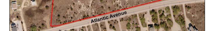
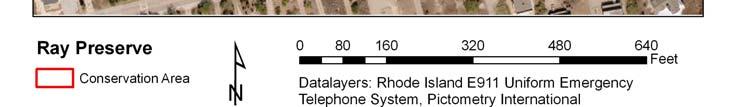
12

13 Landscape Context surrounding uses, nearby conserved land

14 Topography elevation, slope

15 Mapped soil types and descriptions


16 Agricultural Values Current or historic ag use Prime Farmland Soils or Soils of Statewide Importance for Agriculture Surrounding agricultural use
17 Water Resources Presence of wetlands, streams, rivers, coastal water bodies (type, acreage, status) Drainage/watershed information Groundwater / drinking water resources
18 Natural Communities / Flora & Fauna Inventory Characteristic communities Rare species and communities Invasive species FAUNA Birds Great Egret (Ardea alba) Great Blue Heron (Ardea Herodias) American Black Duck (Anas rubripes) Northern Harrier (Circus cyaneus) Red tailed Hawk (Buteo jamaicensis) Ring billed Gull (Larus delawarensis) Yellow rumped Warbler (Dendroica coronata) Saltmarsh Sparrow (Ammodramus caudacutus) American Goldfinch (Carduelis tristis) Mammals (detected by sign) Cottontail Rabbit (Sylvilagus species) Coyote (Canis latrans) White tailed Deer (Odocoileus virginianus) FLORA (species in bold are considered to be widespread and invasive by the Rhode Island Invasive Species Council) [1] Upland / Maritime Scrub Shrub Asiatic Bittersweet (Celastrus orbiculatus) Aster species (Family Asteraceae) Beach Heather (Hudsonia tomentosa) Beach Plum (Prunus maritima) Beach Rose (Rosa rugosa) Blackberry (Rubus species) Chokecherry (Prunus virginiana) Dune Grass (Ammophila breviligulata) Eastern Red Cedar (Juniperus virginiana) Goldenrods (Solidago species) Marsh Elder (Iva frutescens) Multiflora Rose (Rosa multiflora) Northern Bayberry (Morella pensylvanica) Poison Ivy (Toxicodendron radicans) Shadbush (Amelanchier species) Smooth Sumac (Rhus glabra) Spike Grass (Distichlis spicata)

19 Scenic, Historic, and Cultural Resources Historic sites Historic districts Fieldstone walls Scenic areas Viewshed, road frontage
20 Public Access, Recreation & Educational Resources Public access? Trails? Existing uses?
21 Human made Features Especially important to document for future monitoring

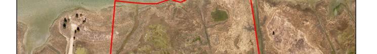
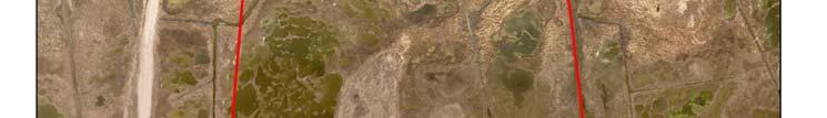
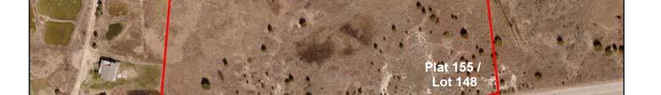
22 Representative Boundary Photography


. Looking north along a stone wall running through the Premises.")
23 Representative Boundary Photography Phot o No. 1 2A 2B 3 4A 4B 5A 5B A 9B Photo Description Looking south along the trail running down the western edge of the Premises. Looking ESE along the northern boundary of the Premises from the northwest corner. Looking SSW along the western boundary of the Premises, along the shoreline, from the northwest corner. Approximate location of picnic table along trail. Looking ESE along stone wall intersecting trail. Looking WNW towards shoreline. Looking ESE along stone wall running along the southern boundary of the Premises. Looking WNW towards shoreline. Looking NNE onto unpaved road running along the western portion of the Premises. Sign posted at entrance to trail running along the southern boundary of the Premises. Tree stand located in deciduous forest in the western portion of the Premises (location approximate). Looking north along a stone wall running through the Premises. Looking ESE along the southern boundary of the Premises. Photo 1 Looking south along the trail running down the western edge of the Premises. Photographed by Carol Lynn Trocki 9/24/2010
24 Resources Rhode Island Land and Water Partnership Online Library Land Stewardship Resources RIDEM Environmental Resources Maps Rhode Island Conservation Stewardship Collaborative: Maps to Support the Work of RI Land Trusts 92db834d62bfa0d6609c9fd5db Vision Appraisal RIGIS Historic Aerial Photos
25 Questions? Carol Lynn Trocki Consulting Conservation Biologist (401)
ASELINE DOCUMENTATION REPORT Almy Property Windmill Hill Farm Little Compton, Rhode Island
 ASELINE DOCUMENTATION REPORT Almy Property Windmill Hill Farm Little Compton, Rhode Island Prepared January 2016 By Carol Lynn Trocki For the Little Compton Agricultural Conservancy Trust Author s Signature:
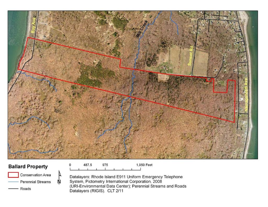
BASELINE DOCUMENTATION REPORT Ballard Property Prudence Island, Portsmouth, Rhode Island
 BASELINE DOCUMENTATION REPORT Ballard Property Prudence Island, Portsmouth, Rhode Island Prepared February 2011 by Carol Lynn Trocki for Prudence Conservancy Author s Signature: Date: 1 TABLE OF CONTENTS
Conservation Area Management Statement
 Conservation Area Management Statement Miller Creek Wildlife Area Resolution #: Approval: Issue Date: Date of Last Revision: Table of Contents 1. Purpose....... 1 2. Property Description...... 1 2.1. Legal
F.O.K.O.S. Friends of Kingston Open Space A GUIDE TO KINGSTON OPEN SPACE
 F.O.K.O.S. Friends of Kingston Open Space A GUIDE TO KINGSTON OPEN SPACE Friends of Kingston Open Space (FOKOS) was formed when a handful of concerned citizens joined together to learn what could be done
BA Collaborators. Driftless Area Initiative The Prairie Enthusiasts Trout Unlimited TNC TCF Natural Resources Foundation of Wisconsin
 BA Collaborators Driftless Area Initiative The Prairie Enthusiasts Trout Unlimited TNC TCF Natural Resources Foundation of Wisconsin The mission of the of the Blufflands Alliance is to actively conserve
Bon Portage Island Conservation Campaign
 Bon Portage Island Conservation Campaign Protecting a Coastal Treasure Final Report to Nova Scotia Habitat Conservation Fund September 2012 Protection of Bon Portage Island Over the course of this two-year
Map 1.1 Wenatchee Watershed Land Ownership
 Map 1.1 Wenatchee Watershed Land Ownership Map 1.1 Wenatchee Watershed Land Ownership The Wenatchee watershed lies in the heart of Washington state in Chelan County. Just larger than the state of Rhode
Pembina Valley Provincial Park. Draft Management Plan
 Pembina Valley Provincial Park Draft Management Plan 2 Pembina Valley Provincial Park Table of Contents 1. Introduction... 3 2. Park History... 3 3. Park Attributes... 3 3.1 Natural... 3 3.2 Recreational...
Pinellas County Environmental Lands
 Pinellas County Environmental Lands In addition to traditional parks and recreation facilities, Pinellas County owns and manages a system of environmental lands that provides specialized resource-based
STORNETTA BROTHERS COASTAL RANCH
 STORNETTA BROTHERS COASTAL RANCH Location: Surrounding Point Arena Lighthouse and immediately south of Manchester State Park Mendocino Co., CA Acres: 1,860 Resources: Over two miles of Pacific Ocean coastline
Treaty Oaks Ranch 323+/- Acres Hood County, Texas $1,776,500
 Bret Polk Mobile: (254) 965-0349 Office: (214) 361-9191 Treaty Oaks Ranch 323+/- Acres Hood County, Texas $1,776,500 LOCATION: The ranch is located in a desirable area 10+/- miles south of Granbury, Texas,
Chapter 2: Summary of Existing Open Space System
 Chapter 2: Summary of Existing Open Space System In 1976, the Wake County Board of Commissioners established the Wake County Parks and Recreation Department in order to provide park facilities and programs
OPG, Nuclear 2
 B iodiversity Assessment Building a Biodiversity Management Plan November 24, 2011 OPG, Nuclear 2 Biodiversity Assessment What habitat, or your site? potential habitat, is available on What species of
3.0 EXISTING PARK & RECREATION SPACE
 3.0 EXISTING PARK & RECREATION SPACE TOWN PARK & RECREATION SPACE An inventory of current parks and recreation area in the Town of Cedarburg is shown in Table 3. These areas total roughly 381.89 acres.
FINAL TESTIMONY 1 COMMITTEE ON RESOURCES UNITED STATES HOUSE OF REPRESENTATIVES. July 13, 2005 CONCERNING. Motorized Recreational Use of Federal Lands
 FINAL TESTIMONY 1 STATEMENT OF DALE BOSWORTH CHIEF Of the FOREST SERVICE UNITED STATES DEPARTMENT OF AGRICULTURE Before the SUBCOMMITTEE ON FORESTS AND FOREST HEALTH And the SUBCOMMITTEE ON NATIONAL PARKS,
CELEBRATE WEST GREENWICH GEOCACHING THROUGHOUT WEST GREENWICH
 CELEBRATE WEST GREENWICH GEOCACHING THROUGHOUT WEST GREENWICH The West Greenwich Land Trust (WGLT) is sponsoring Celebrate West Greenwich, an event designed to celebrate the beauty and history of scenic
MONTAGUE HARBOUR MARINE PROVINCIAL PARK
 MONTAGUE HARBOUR MARINE PROVINCIAL PARK PURPOSE STATEMENT AND ZONING PLAN March 2003 1 MONTAGUE HARBOUR MARINE PROVINCIAL PARK Purpose Statement and Zoning Plan Primary Role The primary role of Montague
MASTER PLAN EXECUTIVE SUMMARY
 Biscuit Run State Park Scottsville Road (State Route 20) Charlottesville, VA 22902 Biscuit Run State Park MASTER PLAN EXECUTIVE SUMMARY Department of Conservation and Recreation Division of Planning and
South Texas Plains. Texas, Our Texas
 South Texas Plains This is a region characterized by considerable variety. Climatically, the South Texas Plains region is sub-humid to dry. The in the north part of the South Texas, erosion of the Edwards
Blanco Creek Ranch Acres, Uvalde County, Texas
 Blanco Creek Ranch 1208.30 Acres, Uvalde County, Texas James King, Agent Office 432 426.2024 Cell 432 386.2821 James@KingLandWater.com Blanco Creek Ranch 1208.30 acres Uvalde County, Texas James King,
Creation of a Community-managed Biodiversity Park in the Saloum Delta of Senegal. Voré Gana Seck Director GREEN Senegal for People, Land, Ocean
 Creation of a Community-managed Biodiversity Park in the Saloum Delta of Senegal Voré Gana Seck Director GREEN Senegal for People, Land, Ocean Rationale for the Creation of the Biodiversity Park F In line
8. Agricultural, Natural and Cultural Resources
 8. Agricultural, Natural and Cultural Resources Agriculture Agriculture is still a prevalent land use in the Town of Medary. Increased housing development has caused a decrease in farmland over the last
SF1363 / HF 1061: Legacy Funding; Conference Agreement
 - Conference 1 Art 1 - Outdoor Heritage Fund 2 3 Prairies 4 WMA, SNA, & Prairie Bank Easement Acq. Phase III 5 Accelerated Prairie Restoration - Phase III 6 MN Buffers for Wildlife & Water 7 Northern Tallgrass
IOWA ORNITHOLOGISTS' UNION - Birding Sites in Dallas County
 IOWA ORNITHOLOGISTS' UNION - Birding Sites in Dallas County Printed on 7/19/2018 Beaver Bottoms Wetland (restricted) (Important Bird Area) GPS Coordinates:, Ownership: Private (see directions for access)
DIXIE HIGHWAY Region of Peel NAI Area # 1304, 1320, 2449, 2625, 3961
 DIXIE HIGHWAY 407 1 Region of Peel NAI Area # 1304, 1320, 2449, 2625, 3961 Toronto and Region Conservation Authority City of Brampton Size: 36 hectares Watershed: Etobicoke Creek Con 4 E, Lots 13, 14 Ownership:
David Magney Environmental Consulting
 David Magney Environmental Consulting DELINEATION OF JURISDICTIONAL WATERS AND RIPARIAN HABITATS FOR LYONS CANYON RANCH, NEWHALL, CALIFORNIA Prepared for: UNITED STATES ARMY CORPS OF ENGINEERS and CALIFORNIA
Establishing a National Urban Park in the Rouge Valley
 STAFF REPORT ACTION REQUIRED Establishing a National Urban Park in the Rouge Valley Date: March 29, 2012 To: From: Wards: Reference Number: Executive Committee Deputy City Manager, Cluster B All p:\2012\cluster
Terrestrial Protected Area Nomination: Central Mangrove Wetland South-West, Grand Cayman
 Terrestrial Protected Area Nomination: Central Mangrove Wetland South-West, Grand Cayman The attached nomination, proposing that a parcel of land in the Central Mangrove Wetland be made a Protected Area
Birch Point Provincial Park. Management Plan
 Birch Point Provincial Park Management Plan 2 Birch Point Provincial Park Table of Contents 1. Introduction... 3 2. Park History... 3 3. Park Attributes... 4 3.1 Natural... 4 3.2 Recreational... 4 4. Park
ISLAND PARK MANAGEMENT PLAN AND GUIDELINES
 ISLAND PARK MANAGEMENT PLAN AND GUIDELINES - 2015 Introduction Island Park was a sand dune on the edge of Lake Huron 12,000 years ago. As the lake receded, it left a river channel, the Thunder Bay River.
BRACEVILLE NATURE PRESERVE Introductions History Present Conditions Future Development Plans Implementation Strategies Statistics
 BRACEVILLE NATURE PRESERVE Introductions History Present Conditions Future Development Plans Implementation Strategies Statistics Introduction Braceville Nature Preserve is one of MetroParks largest preserves.
Marchand Provincial Park. Management Plan
 Marchand Provincial Park Management Plan 2 Marchand Provincial Park Table of Contents 1. Introduction... 3 2. Park History... 3 3. Park Attributes... 4 3.1 Natural... 4 3.2 Recreational... 4 3.3 Additional
Chapter 4.0 Alternatives Analysis
 Chapter 4.0 Alternatives Analysis Chapter 1 accumulated the baseline of existing airport data, Chapter 2 presented the outlook for the future in terms of operational activity, Chapter 3 defined the facilities
Sasagiu Rapids Provincial Park. Draft Management Plan
 Sasagiu Rapids Provincial Park Draft Management Plan 2 Sasagiu Rapids Provincial Park Table of Contents 1. Introduction... 3 2. Background and Park Attributes... 3 2.1 Park History.... 3 2.2 Natural Features...
Preferred Recreation Recommendations Stemilt-Squilchuck Recreation Plan March 2018
 Preferred Recreation Recommendations Stemilt-Squilchuck Recreation Plan March 2018 Below are the recommended recreation ideas and strategies that package together the various recreation concepts compiled
Yard Creek Provincial Park. Management Plan
 Yard Creek Provincial Park Management Plan Draft January 2010 Yard Creek Provincial Park Management Plan Approved by: telàlsemkin/siyam/chief Scott Benton Bill Williams Squamish Executive Director ation
BURGES JAMES GADSDEN PROVINCIAL PARK PURPOSE STATEMENT AND ZONING PLAN
 BURGES JAMES GADSDEN PROVINCIAL PARK PURPOSE STATEMENT AND ZONING PLAN February 2003 BURGES JAMES GADSDEN PROVINCIAL PARK Purpose Statement and Zoning Plan Primary Role The primary role of Burges James
BELLHOUSE PROVINCIAL PARK
 BELLHOUSE PROVINCIAL PARK PURPOSE STATEMENT AND ZONING PLAN March 2003 1 BELLHOUSE PROVINCIAL PARK Purpose Statement and Zoning Plan Primary Role The primary role of Bellhouse Provincial Park is to protect
BIRDING Lake Fayetteville
 BIRDING Lake Fayetteville Lake Fayetteville is an impoundment of Clear Creek, created as a water supply for Fayetteville in 1949. With development of other water supplies, especially Beaver Lake, Lake
2009 RIVER TOWN OF THE YEAR AWARD APPLICATION Supplemental Material Images
 2009 RIVER TOWN OF THE YEAR AWARD APPLICATION Supplemental Material Images Our History The earliest record of settlement along the river is in 1854; one of the earliest in Carroll County. About this time
MONTGOMERY TOWNSHIP OPEN SPACE & PATHWAYS COMMITTEE
 MONTGOMERY TOWNSHIP OPEN SPACE & PATHWAYS COMMITTEE Meetings: 2 nd Wednesday of each month @ 6:30 PM in the Municipal Building Questions? Call the Open Space Coordinator, Lauren Wasilauski, at (908) 359-8211
New England National Scenic Trail. Land and Water Conservation Fund FY2014 Request
 New England National Scenic Trail Land and Water Conservation Fund FY2014 Request National Trails System Land and Water Conservation Fund FY2014 New England National Scenic Trail Tanager Hill Penwood State
DeKalb County Government Sycamore, Illinois. Forest Preserve District Committee Minutes August 22, 2017
 Note: These minutes are not official until approved by the Forest Preserve District Committee at a subsequent meeting. Please refer to the meeting minutes when these minutes are approved to obtain any
The Sand Ridge - Tulare Lake Conservation Report proposes the following recommendations:
 Introduction Creighton Ranch. Pixley National Wildlife Refuge. Allensworth State Historic Park. Sand Ridge. Deer Creek. Located in the Tulare Lake Basin, the Sand-Ridge - Tulare Lake Planning Area features
Triangle Land Conservancy Conservation Area Monitoring Report Carolina North
 Triangle Land Conservancy Conservation Area Monitoring Report Carolina North Property Name: Crow Branch Conservation Area Date of visit: 4/8/2015 County: Orange Property Type: Restrictive Covenants Local
COASTAL CONSERVANCY. Staff Recommendation March 17, 2011 EAST-SLOPE SONOMA MOUNTAIN RIDGE TRAIL PLANNING
 COASTAL CONSERVANCY Staff Recommendation March 17, 2011 EAST-SLOPE SONOMA MOUNTAIN RIDGE TRAIL PLANNING File No. 11-008-01 Project Manager: Sam Jenniches RECOMMENDED ACTION: Authorization to disburse up
An Introduction. The Saginaw River/Bay Area of Concern
 Saginaw River & Bay Area of Concern: Looking Forward Continued Partnerships in the Restoration of Saginaw Bay Michelle Selzer Lake Huron Coordinator & Interim AOC Coordinator Saginaw Bay Watershed Conference
PERFORMANCE INDICATORS
 PERFORMANCE INDICATORS for the greenbelt plan Part 1, 2015 Ontario.ca/mah PERFORMANCE INDICATORS for the greenbelt plan Part 1, 2015 TABLE OF CONTENTS Page Welcome to Greenbelt Plan Performance Indicators
Conservation Lands. Conservation Lands Advisory Committee October 19, 2005
 Conservation Lands Advisory Committee October 19, 2005 Roland DeBlois Chief of Environmental Planning & Code Enforcement Community Development Department Beth Powell Conservation Lands Manager Parks Division
Watershed Report Lower Eleven Point River
 Watershed Report Lower Eleven Point River 1101001104 The Center for Advanced Spatial Technologies at the University of Arkansas has developed the Arkansas Automated Reporting and Mapping System with funding
Blue Trails: Protecting Rivers, Fostering Stewardship
 Blue Trails: Protecting Rivers, Fostering Stewardship What Are Blue Trails? Blue Trails are the water equivalent of hiking trails. They are created to facilitate recreation in and along rivers and water
INFORMATION NOTICE 15-2 Limited & Excluded Lands
 INFORMATION NOTICE 15-2 Limited & Excluded Lands Schedule 1 (Land Description) of onshore petroleum Agreements issued by the Department of Energy details the total hectares calculated. Total hectares are
METROPOLITAN COUNCIL 390 North Robert Street, St. Paul, MN Phone (651) TDD (651)
 TDD (651)") DATE: March 27, 2012 METROPOLITAN COUNCIL 390 North Robert Street, St. Paul, MN 55101 Phone (651) 602-1000 TDD (651) 291-0904 TO: Metropolitan Parks and Open Space Commission FROM: Arne Stefferud, Planning
DATE: March 27, 2012 METROPOLITAN COUNCIL 390 North Robert Street, St. Paul, MN 55101 Phone (651) 602-1000 TDD (651) 291-0904 TO: Metropolitan Parks and Open Space Commission FROM: Arne Stefferud, Planning
Carson City Open Space APNs and , west of Deer Run Road bridge
 32 acres (See separate packet for information on this open space property) OPEN SPACE PROPERTY APNs 008-541-73 and 008-541-92 (north and south sides of the river) Morgan Mill Road River Access Area (parking
Brooker Creek Preserve Management Plan 2008 Update
 Brooker Creek Preserve Management Plan 2008 Update Plan approved by the Board of County Commissioners Pinellas County, Florida 19 August 2008 Pinellas County Department of Environmental Management Environmental
Green Legacy. Securing our. Greenlands Strategy
 Greenlands Strategy Securing our Green Legacy Together we can create an interconnected network of Greenlands for the health and well-being of the environment and future generations Caring for the Credit
Geoscape Toronto The Oak Ridges Moraine Activity 2 - Page 1 of 10 Information Bulletin
 About 13,000 years ago as the Laurentide Ice Sheet melted, glacial meltwater accumulated between the ice sheet and the Niagara Escarpment. This formed a lake basin into which gravel and sand were deposited.
Pinawa Provincial Park. Draft Management Plan
 Pinawa Provincial Park Draft Management Plan Pinawa Provincial Park Draft Management Plan Table of Contents 1. Introduction... 3 2. Park History... 3 3. Park Attributes... 4 3.1 Natural... 4 3.2 Recreational...
TIVERTON, RHODE ISLAND WALK LOOK EXPLORE. 18 miles of Walking Trails through deep woods, pastoral meadows, salt marshes and river vistas
 TIVERTON, RHODE ISLAND WALK LOOK EXLORE 18 miles of Walking Trails through deep woods, pastoral meadows, salt marshes and river vistas WELCOME TO TIVERTON We take great pride in our small town s intimate
Whitemouth Falls Provincial Park. Draft Management Plan
 Whitemouth Falls Provincial Park Draft Management Plan Whitemouth Falls Provincial Park Draft Management Plan Table of Contents 1. Introduction... 3 2. Park History... 3 3. Park Attributes... 4 3.1 Natural...
Watershed Report Blue Mountain Lake-Petit Jean River
 Watershed Report Blue Mountain Lake-Petit Jean River 1111020402 The Center for Advanced Spatial Technologies at the University of Arkansas has developed the Arkansas Automated Reporting and Mapping System
Open Space Index. Town of Philipstown. Adopted January 8, Submitted by: Philipstown Conservation Advisory Committee
 Open Space Index Town of Philipstown Adopted January 8, 2009 Submitted by: Philipstown Conservation Advisory Committee Acting Chair Eric Lind Mark Galezo Andy Galler Lew Kingsley Mike Leonard MJ Martin
Niagara Natural Heritage Park
 A Future Proposal For the Niagara-on-the-Lake DND Lands....... Parks Canada Lakeshore Road Property 1 May, 2016 The Harmony Residents Group We are proposing a Natural Heritage Park be established on the
Triangle Land Conservancy Conservation Area Monitoring Report Carolina North
 Triangle Land Conservancy Conservation Area Monitoring Report Carolina North Property Name: Crow Branch Conservation Area Date of visit: March 16, 2016 County: Orange Property Type: Restrictive Covenants
AGENDA ITEM 5 D WAKULLA ENVIRONMENTAL INSTITUTE (WEI) TRAIL FEASIBILITY STUDY
 TRAIL FEASIBILITY STUDY") March 19, 2018 AGENDA ITEM 5 D WAKULLA ENVIRONMENTAL INSTITUTE (WEI) TRAIL FEASIBILITY STUDY TYPE OF ITEM: Action STATEMENT OF ISSUE The Wakulla Environmental Institute (WEI) Trail is one of several trails
March 19, 2018 AGENDA ITEM 5 D WAKULLA ENVIRONMENTAL INSTITUTE (WEI) TRAIL FEASIBILITY STUDY TYPE OF ITEM: Action STATEMENT OF ISSUE The Wakulla Environmental Institute (WEI) Trail is one of several trails
Wallace Falls State Park Classification and Management Planning Stage 3 Preliminary Recommendations July 18, 2018 Sultan City Hall
 Wallace Falls State Park Classification and Management Planning Stage 3 Preliminary Recommendations July 18, 2018 Sultan City Hall Thanks for coming! This document contains State Parks preliminary recommendations
Bayview Escarpment. Interim Management Statement
 Bayview Escarpment Interim Management Statement Bayview Escarpment Provincial Nature Reserve Interim Management Statement January 15, 1995 REGIONAL DIRECTOR'S APPROVAL STATEMENT This Interim Management
HEART MOUNTAIN VERTEBRATE SURVEY 10 August - 13 August 1999
 HEART MOUNTAIN VERTEBRATE SURVEY 10 August - 13 August 1999 Gary P. Beauvais, Heritage Zoologist Wyoming Natural Diversity Database / University of Wyoming 19 August 1999 =====================================================================
Discover. Ashhurst Domain. Nature s Playground
 Discover Ashhurst Domain Nature s Playground Discover Step back into New Zealand, Aotearoa, of generations long gone. Discover lush natural surrounds echoing with rich birdsong in one of the Manawatu s
The Frank Church River of No Return Wilderness
 ALLIANCE FOR WILDERNESS EDUCATION AND STEWARDSHIP PO Box 2667, Bellingham, WA 98227-2667 Tele: 360-927-1804 Fax: 360-527-9679 bradt@wildernessalliance.org www.wildernessalliance.org STEWARDS OF AMERICA
OWNED LAND ACTIVITIES REPORT February 2012
 OWNED LAND ACTIVITIES REPORT February 2012 BULL RUN MOUNTAINS NATURAL AREA PRESERVE A tremendous number of projects are underway on the Preserve. Currently VOF is working with the Smithsonian Conservation
MARBLE RIVER PROVINCIAL PARK
 MARBLE RIVER PROVINCIAL PARK PURPOSE STATEMENT AND ZONING PLAN March 2003 MARBLE RIVER PROVINCIAL PARK Purpose Statement and Zoning Plan Primary Role The primary role of Marble River Park is to protect
Management Direction Statement
 Management Direction Statement Rocky Fork State Park 4/18/2017 Table of Contents Rocky Fork State Park Introduction 4 Purpose of Management Direction Statements Setting and Context Park Themes Mission
County of Riverside - PSEC Project General Habitat Assessment Appendix A
 County of Riverside - PSEC Project General Habitat Assessment Appendix A Paradise Paradise The Paradise study area is located in the mountains within the eastern portion of the City of Norco. Existing
% farmers/private landowners in watershed applying BMPs. Other (Number of participants completed the training)
") Easygrants ID: 23803 National Fish and Wildlife Foundation NFWF/Legacy Grant Project ID: 0302.10.023803 U. S. Coral Reef Task Force Partnership Initiative 2010 - Submit Final Programmatic Report (Activities
Easygrants ID: 23803 National Fish and Wildlife Foundation NFWF/Legacy Grant Project ID: 0302.10.023803 U. S. Coral Reef Task Force Partnership Initiative 2010 - Submit Final Programmatic Report (Activities
Management Plan For Mills Riverside Park
 DRAFT Management Plan For Adopted Prepared by: Jericho Underhill Park District P. O. Box 164 Underhill, VT 05489 Table of Contents Purpose... 3 History... 4 General Description of the Property... 5 Trail
The Vision for the San Juan Islands Scenic Byway
 The Vision for the San Juan Islands Scenic Byway 2 Judd Cove, Orcas Island, Courtesy of Kurt Thorson (kurtthorson.com) and San Juan County Land Bank Vision for the San Juan Islands Scenic Byway The San
Cuyahoga Valley National Park Ohio
 Cuyahoga Valley National Park Ohio Brandywine Falls The Ledges The Beaver Marsh Temperate Deciduous Forest How To Get There... Located between Cleveland & Akron, Ohio Cuyahoga Valley National Park can
ROBERTS CREEK PROVINCIAL PARK MASTER PLAN. November, 1981
 Ministry of Lands, Parks and Housing Parks and Outdoor Recreation Division Park Operations Branch North Vancouver, B. C. ROBERTS CREEK PROVINCIAL PARK MASTER PLAN November, 1981 Mr. G. Trachuk Director
I. PREFACE II. THE PARTNERSHIP
 I. PREFACE This document is the "local" plan for the management of the Appalachian Trail in Maine from Maine Highway 26 in Grafton Notch to the summit of Katahdin. It is a part (the other being the Appalachian
Dungeness Recreation Area County Park Master Plan
 Dungeness Recreation Area County Park Public Outreach Meeting October 10, 2007 Project Overview USFWS Site Dungeness Recreation Area County Park Meeting Objectives: Re-Introduce project; provide status
RATTLESNAKE HILL PHILLIPS, HARRIS FARM, LIME KILN & QUARRY
 Town of, MA Trails Map 6a SPLIT ROCK PRIMARY SECONDARY PRIVATE PRIVATE PROPERY STAY ON HEAD FUTURE TO SKINNER (NOT MARKED) 0 miles 0.25 0.250 0.5 Mapbox, Data Odbl, OpenStreetMap contributors primary use
Bratt ") 4. % F l o r i d a D e s i g n a t e d P a d d l i n g T r a i l s ") 164 «97 ") 99. Barrineau Park. M a p 1. M a p 2.
 4. % F l o r i d a D e s i g n a t e d P a d d l i n g T r a i l s ) 164 «97 ) 99. Barrineau Park. M a p 1. M a p 2.") F l o r i d a D e s i g n a t e d P a d d l i n g T r a i l s Bratt ") 4 Bluff Springs «4 Jay ") P e r d i d o R i v e r P e r d i d o CR R99A i v Walnut e r Hill ") 164 ") 97A «89 «97 ") 197 Barrineau
F l o r i d a D e s i g n a t e d P a d d l i n g T r a i l s Bratt ") 4 Bluff Springs «4 Jay ") P e r d i d o R i v e r P e r d i d o CR R99A i v Walnut e r Hill ") 164 ") 97A «89 «97 ") 197 Barrineau
Bat Cave Canyon Ranch 2,920 acres Jeff Davis County, Texas
 Bat Cave Canyon Ranch 2,920 acres Jeff Davis County, Texas James King, Agent Office 432.426.2024 Cell 432.386.2821 James@KingLandWater.com Bat Cave Canyon Ranch 2,920 acres Jeff Davis County, Texas James
ABERDEEN HARBOUR EXPANSION PROJECT November Volume 3: Technical Appendices. Appendix 17-B SLVIA - ABERDEEN GREEN SPACE NETWORK
 ABERDEEN HARBOUR EXPANSION PROJECT November 2015 Volume 3: Technical Appendices Appendix 17B SLVIA ABERDEEN GREEN SPACE NETWORK APPENDIX 17B: SLVIA ABERDEEN GREENSPACE NETWORK 17B SLVIA Aberdeen green
EXECUTIVE SUMMARY PROGRAM DEVELOPMENT REPORT PURPOSE EXISTING SETTING EXPANDING PARKLAND
 EXECUTIVE SUMMARY PROGRAM DEVELOPMENT REPORT PURPOSE As the culmination of the first phase of the master planning process, this Program Development Report creates the framework to develop the Calero County
VARGAS ISLAND PROVINCIAL PARK
 VARGAS ISLAND PROVINCIAL PARK PURPOSE STATEMENT AND ZONING PLAN February 2003 VARGAS ISLAND PROVINCIAL PARK Purpose Statement and Zoning Plan Primary Role The primary role of Vargas Island Park is to protect
Galveston Bay Estuary Program. Carla G. Guthrie, Ph.D. Galveston Bay Council Member Texas Water Development Board
 Galveston Bay Estuary Program Carla G. Guthrie, Ph.D. Galveston Bay Council Member Texas Water Development Board The statements contained in this presentation are my current views and opinions and are
2. Goals and Policies. The following are the adopted Parks and Trails Goals for Stillwater Township:
 D. PARKS AND TRAILS 1. Introduction Stillwater Township s population is relatively low, with most residents living on rural residences on large lots. The need for active park space has been minimal in
Achieving Nature Conservation in Hong Kong s Protected Areas System
 Achieving Nature Conservation in Hong Kong s Protected Areas System Winnie PW KWOK Senior Wetland and Fauna Conservation Officer Agriculture, Fisheries and Conservation Department Government of HKSAR 4_001.html?pubdate=
Town of Oakfield Agricultural and Farmland Protection Plan
 SECTION III COMMUNITY OVERVIEW A. Regional Setting / Location The Town of Oakfield is located in the northwestern portion of Genesee County. Located west of New York's Finger Lakes, the Town is uniquely
Rule Governing the Designation and Establishment of All-Terrain Vehicle Use Trails on State Land
 Rule Governing the Designation and Establishment of All-Terrain Vehicle Use Trails on State Land 1.0 Authority 1.1 This rule is promulgated pursuant to 23 V.S.A. 3506. Section 3506 (b)(4) states that an
GENERAL MANAGEMENT PLAN
 GENERAL MANAGEMENT PLAN Long-range management guidance focused on the specific natural resources, historic-cultural resources, recreation opportunities, and the educationinterpretation opportunities for
Classifications, Inventory and Level of Service
 Classifications, Inventory and Level of Service Section 3 Kenmore Park, Recreation and Open Space Plan 1 P a g e Classifications and Inventory Park Classifications Kenmore classifies its parks based upon
Wallace Lake Provincial Park. Draft Management Plan
 Wallace Lake Provincial Park Draft Management Plan Wallace Lake Provincial Park Draft Management Plan Table of Contents 1. Introduction... 3 2. Park History... 3 3. Park Attributes... 4 3.1 Natural...
Environment and Natural Resources Trust Fund 2014 Request for Proposals (RFP)
") Environment and atural Resources Trust Fund 2014 Request for Proposals (RFP) Project Title: State Parks and Trails Land ERTF ID: 181-G Category: G. Land for Habitat and Recreation Total Project Budget:
Environment and atural Resources Trust Fund 2014 Request for Proposals (RFP) Project Title: State Parks and Trails Land ERTF ID: 181-G Category: G. Land for Habitat and Recreation Total Project Budget:
EPPER PASSAGE PROVINCIAL PARK PURPOSE STATEMENT AND ZONING PLAN
 EPPER PASSAGE PROVINCIAL PARK PURPOSE STATEMENT AND ZONING PLAN August 2003 1 EPPER PASSAGE PROVINCIAL PARK Purpose Statement and Zoning Plan Primary Role The primary role of Epper Passage Park is to protect
European Diploma for Protected Areas. Volcanic phenomena of the Tihany Peninsula (Hungary) Appraisal Report July 3th 7 th, 2017
 Appraisal Report July 3th 7 th, 2017") European Diploma for Protected Areas Volcanic phenomena of the Tihany Peninsula (Hungary) Appraisal Report July 3th 7 th, 2017 P. Galland Frebruary 2018 Background The European Diploma for Protected Areas
European Diploma for Protected Areas Volcanic phenomena of the Tihany Peninsula (Hungary) Appraisal Report July 3th 7 th, 2017 P. Galland Frebruary 2018 Background The European Diploma for Protected Areas
Participating quarry information (Long version)
") Participating quarry information (Long version) 1. Contact information Company: PT Indocement Tunggal Prakarsa Tbk. Cirebon Plant Quarry: Latitude / Longitude: City: Region: Country: Cirebon Quarry 6 o
Participating quarry information (Long version) 1. Contact information Company: PT Indocement Tunggal Prakarsa Tbk. Cirebon Plant Quarry: Latitude / Longitude: City: Region: Country: Cirebon Quarry 6 o
Mackinnon Esker Ecological Reserve Draft - Management Plan
 Mackinnon Esker Ecological Reserve Draft - Management Plan May 2011 Photo Credit: This document replaces the direction provided in the Carp Lake Provincial Park and Protected Area and Mackinnon Esker Ecological