CONSTABLE CREEK LOILA TIER RESERVE A NEW PROTECTED AREA FOR NORTH EAST TASMANIA
|
|
|
- Abigayle Ellis
- 6 years ago
- Views:
Transcription


1 CONSTABLE CREEK LOILA TIER RESERVE A NEW PROTECTED AREA FOR NORTH EAST TASMANIA North East Bioregional Network July 2007
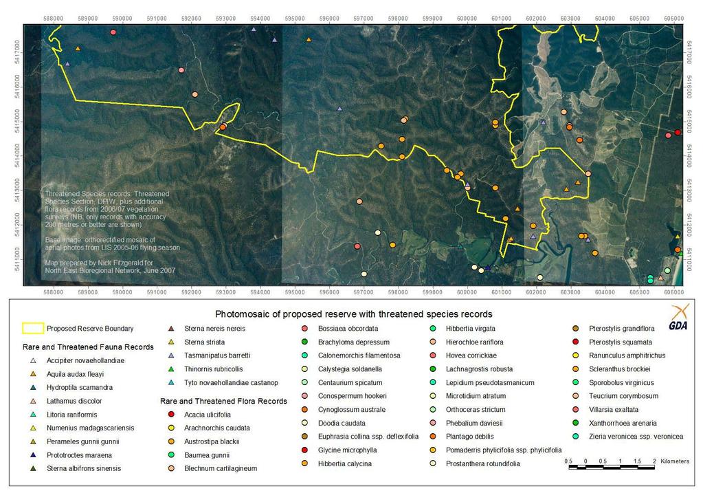
2 Contents Executive Summary 3 Recommendations 3 Reserve Area 4 Description of the Constable Creek Loila Tier area 4 Geology 4 Landscape and drainage 4 Vegetation 6 Natural Values 6 Flora of Conservation Significance 6 Fauna of Conservation Significance 8 Vegetation Communities of Conservation Significance 9 Biodiversity 12 Naturalness 13 Recreation and education 14 References 15 Maps 16 Land Tenure 16 Geology 16 Vegetation 17 Photo-mosaic and threatened species 18 National Estate and Recreation 20
3 Executive Summary This document presents a proposal for a new reserve in north-east Tasmania. The proposed Constable Creek Loila Tier Reserve covers an area of approximately 13,200 hectares of largely pristine native forest, heathland and watercourses. Constable Creek is a permanent watercourse which flows into Georges Bay at St Helens on Tasmania s east coast. The 4000-hectare Constable Creek catchment is remarkable for its natural condition. The region is a wilderness area within walking distance of the St Helens town centre (the largest population centre on Tasmania s East Coast). The Constable Creek catchment, adjoining Loila Tier and the middle reaches of the Scamander River, provides an important landscape link between the coast and the highlands. This area is an outstanding example of dry forest vegetation with a diverse range of plant and animal species. A Constable Creek Loila Tier Reserve will ensure protection for many rare and threatened species in addition to under-reserved vegetation types (such as black gum forest and oldgrowth ironbark forest). Furthermore the natural integrity of the Constable Creek area, with its multiple forested hills, provides a scenic backdrop to the Georges Bay district, which is a major holiday destination. Recreational activities within the proposed reserve provide a variety of visitor experiences to complement the established attractions of St Helens and the coastal zone. Constable Creek and associated waterways are notable for their integrity and naturalness. This reserve proposal not only protects this largely undisturbed landscape but also contributes to the health of Medeas Cove Conservation Area and Georges Bay. Recommendations The proposed Constable Creek Loila Tier Reserve be proclaimed a State Reserve or similar status of reserve under the Nature Conservation Act A management plan for the reserve developed in conjunction with relevant stakeholders following biological, geological, historical and cultural surveys of the area. Biodiversity survey plots established in the reserve for long-term ecological monitoring of flora, fungi, invertebrates, aquatic fauna, etc.
4 Reserve Area There is a clear deficiency of reserves in the St Helens hinterland. Existing reserves in the area are small and isolated and many have only informal reserve status. By filling a gap between the Avenue River Forest Reserve in the south and Mount Pearson State Reserve to the north this reserve will contribute significantly to a connected series of protected land along the east coast. Furthermore the Constable Creek Reserve proposal increases connectivity between the coastal environment of Georges Bay (with associated protected areas such as Medeas Cove, Humbug Point and St Helens Point) and the highland reserves of Mount Victoria and Blue Tier. This connectivity is important because it allows the continuity of native habitats along environmental gradients (e.g. in altitude and distance from the coast) and provides a corridor for animals and plants to move through the landscape over short and long time scales. The proposed reserve is around 13,200 hectares of State Government administered land presently classified State Forest with small areas of Crown Land (currently being reviewed under the Crown Land Assessment and Classification Project). A single parcel of private land covering around 20 hectares is surrounded by the proposed reserve. The proposed reserve will consolidate existing informal reserves (from the Regional Forest Agreement and Community Forest Agreement processes) and sites recognised for National Estate values by the Commonwealth Government. Description of the Constable Creek Loila Tier area Geology Geologically the proposed reserve covers two major rock types. Most of the reserve area is Ordovician mudstone which typically produces poor soils. More fertile soils develop on the Devonian granite which occurs in the Launceston Creek and upper Constable Creek area in the northwest of the proposed reserved. Landscape and drainage Most of the proposed reserve is in two main catchments: Constable Creek and Scamander River. All of the watercourses in this area eventually reach the Tasman Sea on Tasmania s east coast. The Scamander River and Constable Creek are the only permanently flowing watercourses; the other major creeks typically flow for most of the year and become dry in summer. Several waterfalls occur where watercourses meet resistant granite bedrock. In the mudstone areas the landscape is characterised by deep creek gullies, steep slopes and narrow ridges. The landscape in the eastern part of the area is defined by prominent ridges such as Scamander Tier and Loila Tier trending roughly north-south. The highest points are Copper Show Ridge (390 m), Loila Pinnacle (375 m) and Flagstaff Hill (328 m). Boggy Creek is a small catchment draining from Flagstaff Hill directly into Georges Bay. The eastern slopes of Scamander Tier drain via small creeks into the coastal lagoon of Dianas Basin. The eastern slopes of Loila Tier feed Arm Creek which joins the Scamander River estuary around 10 km from the river mouth. The Constable Creek catchment occupies the centre and northwest of the proposed reserve. The western half of the Constable Creek catchment and the adjoining Launceston Creek comprise generally low hills and broad flats, while the eastern half is steep rugged terrain including Mount Echo and the western slopes of Scamander Tier. Constable Creek then passes through around 2 km of wetland and saltmarsh

5 before reaching Medeas Cove at St Helens. Slopes tend to be less steep in the granite landscape in the northwest of the proposed reserve and in this area there are alluvial flats in the broader valleys. The western part of the Constable Creek reserve is in the Scamander River catchment and includes a variety of landforms from alluvial flats (eg Helens Marsh) and granite knolls (eg Granite Knob) to highly
6 dissected slopes at Bridge Creek. Elevation reaches 398 metres on an unnamed ridge at the southwest corner of the proposed reserve. Vegetation The dominant vegetation in this region is dry sclerophyll forest with an open canopy and sparse understorey. Extensive areas are dominated by Ironbark (Eucalyptus sieberi), particularly on the driest sites. Dry sclerophyll forest dominated by either black peppermint (E. amygdalina) or stringybark (E. obliqua) occurs in sizable patches. Damp gullies and shaded lower slopes support small stands of wet sclerophyll forest dominated by stringybark (E. obliqua). Damp sclerophyll forest with a mix of eucalypt species occurs in small sheltered patches on the higher ridges, apparently where low cloud frequently provides extra moisture as fog and drizzle. There are only small areas of non-forest vegetation. Wet heathland comprising dense sedges and shrubs with few or no trees occurs on flat areas with poor drainage. The margins of these heathlands supports small patches of black gum (E. ovata) forest and woodland. Damp forest dominated by white gum (E. viminalis) or a combination of eucalypt species with a shrubby and sedgey understorey occurs in small patches on alluvial flats beside the Scamander River. Vegetation in this area is determined largely by moisture availability and as such distinct changes in vegetation composition and structure are evident with changes in the landscape over short distances such as between north-facing and south-facing slopes. A small area of pine plantation occurs in the south-east corner of the proposed reserve this site would be easily regenerated to native forest, providing an important landscape link with the Scamander Forest Reserve. Natural Values The Constable Creek Loila Tier region is a rich and well preserved natural environment. The area contains extensive areas of mature forest, a variety of vegetation types, several threatened species and significant biodiversity. Flora of Conservation Significance Table 1. Threatened flora known from Proposed Reserve or likely to be present Name Common Name Tasmanian status* National status** Distribution in Proposed Reserve Acacia mucronata ssp. dependens Acacia siculiformis Acacia ulicifolia blunt caterpillar wattle dagger wattle juniper wattle Not recorded but suitable habitat in riparian areas. Not recorded but known within 1 km of northeast boundary and suitable habitat present. Not recorded but known within 4 km of eastern boundary and suitable habitat present.
7 Arachnorchis caudata Baumea gunnii Blechnum cartilagineum Bossiaea obcordata Brachyloma depressum Conospermum hookeri Desmodium gunnii Euphrasia collina ssp. deflexifolia Hibbertia calycina Hibbertia virgata Hierochloe rariflora Hovea corrickiae Phebalium daviesii tailed spider orchid Vulnerable No recent known records in the vicinity. Suitable habitat present. slender Recorded from Constable and Launceston twigsedge creeks. Likely to occur elsewhere in riparian and marsh situations. gristle fern Vulnerable No reliable records. Garrett (1996) notes that a small population was known beside Constable Creek in the early 1980s however he states that the present [1996] status of this population is unknown. spiny bossiaea spreading heath variable smokebush slender tick trefoil eastern eyebright lesser guinea flower twiggy guinea flower cane holygrass glossy purple-pea davies waxflower Vulnerable Vulnerable Vulnerable Critically Not recorded but known within 3 km of southern boundary and suitable habitat present. Not recorded but known within 1 km of northeast boundary, however probably no suitable habitat. Not recorded but known within 0.5 km of northern boundary and some suitable habitat present on granite. Not recorded but known within 2 km of eastern boundary and some suitable habitat present in damper situations. Recorded from Constable Creek south of Mount Echo. Some potential habitat elsewhere in the area. Reserve proposal covers prime habitat for this species with several known populations in the northeast and southeast of the area. Recorded from Boggy Creek in the northeast of the proposed reserve. Recorded from several locations in the area and likely to be widespread. Several known populations at Constable Creek, Loila Tier and the western end of the proposed reserve. No known natural populations. Some plants were planted at Beahrs Creek (TSU 2001), although the status of this population is not known.
8 Plantago debilis Pomaderris phylicifolia ssp. phylicifolia Prostanthera rotundifolia Pterostylis grandiflora Teucrium corymbosum Scleranthus brockiei shade plantain narrowleaf dogwood roundleaf mintbush superb greenhood forest germander brock knawel Vulnerable Known from 3 widely separated records and likely to be extensive given the widespread suitable habitat. Not recorded but known within 3 km of southern boundary and some suitable habitat present in riparian situations. Not recorded but known in close proximity (less than 1 km) to proposed area and potential habitat present. No reliable records. Likely to be suitable habitat. Not recorded but known within 2 km of southern boundary and some suitable habitat present. Not recorded but known in close proximity (less than 0.5 km) to northeast boundary and some potential habitat present. * as per Tasmanian Threatened Species Protection Act 1995 ** as per Commonwealth Environment Protection and Biodiversity Conservation Act 1999 The proposed reserve would protect prime habitat and significant populations of the following threatened flora species: lesser guineaflower (Hibbertia calycina), glossy purplepea (Hovea corrickiae) and cane holygrass (Hierochloe rariflora). Austral grasstree (Xanthorrhoea australis) is not a listed threatened species, however it is considered a priority species under the Tasmania-Commonwealth Regional Forest Agreement. Ironbark (Eucalytpus sieberi) forests in the proposed reserve contain good populations of austral grasstrees. Phytophthora root-rot is a major threat to this species and consequently the prevention of Phytophthora infection is important to ensure the future viability of austral grasstrees. Fauna of Conservation Significance Table 2. Threatened fauna recorded from Proposed Reserve and surrounding area Name Accipiter Aquila audax fleayi Dasyurus maculatus maculatus Common Name grey goshawk wedge-tailed eagle spotted-tail quoll Tasmanian status Endangered National status Distribution in Proposed Reserve No records but within Estimated Geographic Range. Suitable habitat particularly in the wetter western part. Endangered Endangered At least 6 known nest sites. Widespread foraging habitat. Vulnerable Likely to be widespread in denser forests.

9 Haliaeetus leucogaster Hoplogonus simsoni Hoplogonus vanderschoori Lathamus discolor Perameles gunnii gunnii Tasmanipatus barretti Thylacinus cynocephalus white-bellied sea eagle simson s stag beetle Vulnerable Vulnerable Vulnerable Within Estimated Geographic Range. Two known nesting sites in the northeast of the proposed reserve at Boggy Creek. No records but within Estimated Geographic Range. Suitable habitat restricted to damp mature forest sites. No records but within Estimated Geographic Range. Suitable habitat restricted to damp mature forest sites. swift parrot Endangered Endangered No records but within Estimated Geographic Range. Suitable nesting and foraging habitat occurs at Scamander Tier. eastern barred bandicoot giant velvet worm Provisionally vulnerable Likely to occur in areas of grassy or sedgey habitat. Widespread in gullies and damp shaded slopes. thylacine Extinct Extinct Extinct. Tyto masked owl Endangered Recorded from northeastern boundary near Boggy Creek. Likely to be widespread in the area. The proposed reserve would protect prime habitat and significant populations of the following threatened fauna species: wedge-tailed eagle (Aquila audax fleayi) and giant velvet worm (Tasmanipatus barretti). The area also provides habitat for species considered to be of conservation significance which do not meet the criteria for listing as threatened species. Typically these are species which depend upon mature forests, especially those which require specific types of tree hollows for nesting. Habitat modelling for the yellow-tailed black cockatoo (Calyptorhynchus funereus) shows the Constable Creek Loila Tier accounts for a significant proportion of habitat for this species in north-east Tasmania. Although presently not rare, the population of this species is predicted to decline by more than 40 % in northeast Tasmania in response to reductions in feeding and breeding habitat associated with loss of mature forest (Fox et al. 2004). Vegetation Communities of Conservation Significance» Paperbark (Melaleuca ericifolia) swamp forest Swamp forest has a dense canopy of paperbark (M. ericifolia) around 10 metres tall over a sparse understorey of sedges and ferns. It occurs in narrow bands on the margins of estuaries and lagoons in coastal northern Tasmania. A small patch of swamp forest occurs on E. ovata forest and buttongrass at Helens Marsh
 forest Forest dominated by black gum (E.")
10 Crown Land along Boggy Creek near Georges Bay. Swamp forest is vulnerable to damage by fire, land clearing, weed invasion, sea level rise and changes in catchment hydrology. This vegetation community is considered rare and endangered and under-reserved in Tasmania.» Black gum (Eucalyptus ovata) forest Forest dominated by black gum (E. ovata) generally has a relatively short (under 20 metres) and open canopy with an understorey varying from dense shrubby to open sedgey. Black gum forest prefers flat areas, particularly river flats, which has led to extensive clearing of this forest type. Very small patches of black gum forest occur on the margins of heathy marshes in the upper reaches of Launceston and Constable creeks. More extensive black gum forest occurs in the Scamander River catchment where this forest type forms a mosaic with open sedgeland and heathland on broad creek flats. Black gum forest on private land at Steels Marsh is protected by conservation covenant, however the forest extends onto adjoining State Forest. An excellent example of this forest type is found at Helens Marsh where it occurs in a mosaic with buttongrass moorland and wet heath. It is estimated that less than 5 % of the original extent of black gum forest remains in the Flinders bioregion and with a similar degree of loss (around 92%) statewide this community is considered endangered in Tasmania.» Black gum (Eucalyptus ovata) heathy woodland Heathland with sparse emergent black gum (E. ovata) up to 8 metres. Occurs in association with black gum forest and various types of heathland, either as an intermediate successional stage between heathland and forest, or as an environmental transition between these vegetation types (where tree growth is physiologically limited due to waterlogging). A diverse heathy understorey features dense shrubs 1 to 2 metres tall over dense low shrubs, sedges and rushes. This vegetation community has recently been recognised as distinct from black gum forest and as yet has not been mapped or analysed for conservation status, however it is likely to justify a similar status to black gum forest (possibly rare and endangered).» Oldgrowth Ironbark (Eucalyptus sieberi) forest Oldgrowth E. sieberi forest with grasstree understorey Forest dominated by Ironbark is the major vegetation type in the proposed reserve and corresponds to two TASVEG communities. The Ironbark communities are differentiated by geology since the plant species composition of the understorey varies notably in response to soil type. Ironbark forest on granite (TASVEG = DSG) occurs in the north and west of the proposed reserve, while the mudstone soils in the south-eastern area corresponds to Ironbark forest on other substrates (DSO). Both forest communities are relatively common in the Flinders bioregion, however oldgrowth ironbark forest is naturally rare and as such is a high priority for conservation. 10
11 » Oldgrowth Black peppermint (Eucalyptus amygdalina) forest Black gum forest is extensive across lowland northeastern Tasmania, particularly the coastal black peppermint community (DAC) which occurs on sandy and granitic soils. Although this community is very common, it is frequently highly disturbed and rarely occurs as oldgrowth. Table 3. Vegetation communities of conservation significance in proposed reserve Vegetation community TASVEG code Oldgrowth Statewide status* Bioregional status Extent in proposed reserve (hectares) Eucalyptus DOV no Endangered Endangered 15 ovata forest Eucalyptus DOV no Endangered Endangered 6 viminalis sedgey forest Eucalyptus DOW no?? 12 ovata heathy woodland Eucalyptus DSG yes and and depleted 50** sieberi forest on granite depleted oldgrowth Eucalyptus DSO yes and and depleted 50** sieberi forest on granite depleted oldgrowth Eucalyptus DAC yes Non-threatened 100** amygdalina coastal forest Eucalyptus WOB yes and depleted 50** obliqua wet forest oldgrowth Melaleuca NME yes Vulnerable and depleted 1 ericifolia swamp forest oldgrowth Riparian SRI n/a Vulnerable - 2 vegetation Saline wetland AUS n/a Vulnerable - 1» * as per DPIWE Threatened Native Vegetation Communities Version 6 ** estimated extent of oldgrowth based on RFA 1:250,000 scale mapping Oldgrowth Stringybark (Eucalyptus obliqua) wet forest Along with black peppermint and ironbark, stringybark is one of the most widespread forest dominants in the Scamander St Helens region. Wet stringybark forest occurs in damp and fire protected gullies. Some instances of this forest type are oldgrowth, but oldgrowth development is probably limited by the fire regimes in the region. 11
.")

12 Stringybark trees form better trunk and branch hollows than the other common eucalypt species in this region, so oldgrowth stringybark forest provides high quality habitat for a number of hollow-nesting animals including several species of conservation significance (e.g. yellow-tailed black cockatoo, masked owl, swift parrot).» Riparian scrub A narrow band of dense shrubs occupies riverbanks in some situations, particularly flood prone areas, such as parts of the middle reaches of Constable Creek.» Saline wetland A very small area of saline wetland occurs in the north-east corner of the proposed reserve at the mouth of Boggy Creek. Native sedges and rushes dominate this community which is bordered by paperbark swamp forest. Extensive saline wetland and saltmarsh is found at Medeas Cove, including at the estuary of Constable Creek. These estuarine communities are influenced by inputs from Launceston, Constable and Nephele creeks and as such the protection of these catchments in the proposed reserve will help maintain these ecosystems. Biodiversity Few fauna and flora surveys have been conducted in the Constable Creek Loila Tier area. Because it is an extensive area of relatively undisturbed vegetation it would be expected to provide a representative example of subcoastal vegetation, flora and fauna from the northern east coast. Vegetation types and species associated with both major geological types in this region, Permian mudstone and Devonian granite, are well represented in the reserve area. Fungi, bryophytes and invertebrates are particularly poorly surveyed elements of the biodiversity in this area. The National Estate assessments of Mount Echo and Loila Tier note that these areas are important as centres for fauna endemism, primitive and relictual fauna, contemporary refugia and for fauna species richness having a high diversity of invertebrate species within a restricted area. They have special importance within the Tasmanian forest region in terms of both space (biogeographical relicts) and time (phylogenetic relicts). Mount Echo and Loila Tier contain communities that are strongly associated with climatic and topographic factors that confer a degree of protection from endangering processes such as fire and disease. These refugia have two important roles: they provide locations for the conservation of species and communities and they provide sources for population expansion if limiting conditions prevail. (Australian Heritage Database) Additionally, Loila Tier and Skyline Tier are recognised as important biogeographically for a high concentration of flora species at the limits of their distributional range, being the northern limit of many east coast species (for example, Eucalyptus pulchella, E. tenuiramis). 12


13 Naturalness The Constable Creek catchment covers an area of approximately 4000 hectares of which around 300 hectares has been logged and 50 hectares has been affected by mining. More than 90% of the catchment is in a natural state. Within the catchment the Mount Echo area provides an excellent example of natural condition, as such the Australian Heritage Commission determined that 76.5% of this 356-hectare site has the highest level of biophysical naturalness, with the remainder meeting the second highest rating. View north-east from Carters Track Lookout towards Georges Bay and St Helens The steep terrain throughout much of the proposed reserve area has contributed to a lack of roads and development. The vegetation in the area is generally in good to excellent condition with only isolated instances of major disturbance such as clearfell logging or alluvial mining. In comparison, much of the dry forest in the wider region has been lost or degraded by logging, mining, frequent fires and land clearing. The Constable Creek Loila Tier area contains perhaps the most extensive good condition mature ironbark forest in Tasmania. Furthermore the proposed reserve area is notable for a lack of introduced species, particularly environmental weeds which are a threat to biodiversity. An environment with such good natural condition provides an important benchmark for scientifically determining baseline biodiversity and water quality against which other areas can be assessed. This is important in a broader landscape subject to increasing human-caused disturbance and fragmentation in addition to the potential impacts of climate change. Unnamed waterfall on lower reaches of Constable Creek 13

14 Recreation and education The Constable Creek area contains several accessible attractions for visitors and local residents to enjoy. Waterfalls and swimming holes, bushwalking, forest drives and scenic lookouts provide a variety of visitor experiences. Natural attractions include Ironbark Falls, the Dreaming Pools and coastal views from Skyline Tier. There is considerable educational value in the area. Being close to St Helens, Constable Creek provides a valuable opportunity for students to study an entire pristine water catchment from hills to wetland and sea. A tourist guide to the Break O Day Municipality lists Flagstaff Hill and Scamander Tier as scenic attractions, noting that the Tier provides a magnificent view of the Tasman Sea. Flagstaff Hill provides a panoramic view of St Helens, Georges Bay and surrounding coastline. Loila Tier Road features several good lookouts with views inland to Ben Lomond and south to the prominent peaks around St Marys. Several roads with scenic forests access Loila Tier, providing a variety of options for tourist drives. At the western end of the proposed reserve, Beahrs Creek is an attractive forested gully with road access, with the option of a short walk to a pleasant picnic spot at Granite Falls. The more adventurous can make the short scramble through open forest to the summit of Granite Knob for excellent views. The Scamander Forest Reserve at the southeast edge of the proposed reserve provides visitor infrastructure including picnic and camping facilities and is a popular place for fishing and canoeing. 14 Bushwalker on Granite Knob
15 References Australian Heritage Database, Loila Tier and Mount Echo. Department of Environment and Water Resources. Bryant, S. L. & Jackson, J. (1999). Tasmania s Threatened Fauna Handbook. Threatened Species Unit, Nature Conservation Branch, DPIWE. CARSAG (2004). Assessing reservation priorities for private forested land in Tasmania, A report of the Comprehensive, Adequate and Representative Scientific Advisory Group (CARSAG) of the Private Forest Reserves Program, September Department of Primary Industries, Water and Environment, Hobart. DPIW (2006) Crown Land Assessment and Classification Consultation Report and Recommended Allocations for the Municipality of Break O Day DPIW, Natural Values Atlas. Fox et al. (2004) Linking landscape ecology and management to population viability analysis. University of Melbourne, prepared for Forestry Tasmania. Garrett, M. (1996) The ferns of Tasmania: their ecology and distribution. Tasmanian Forest Research Council, Hobart. Harris, S. and Kitchener, A. (2005). From Forest to Fjaeldmark: Descriptions of Tasmania s Vegetation. Department of Primary Industries, Water and Environment, Printing Authority of Tasmania. Hobart. Jones, D., Wapstra, H., Tonelli, P. & Harris, S. (2000) The Orchids of Tasmania. Melbourne University Press, Victoria. Kirkpatrick, J.B. (1996) The Northeast in its Context. In: Mesibov, R. (Ed.) Biogeography of northeast Tasmania. Queen Victoria Museum and Art Gallery, Launceston. Lazarus, E., Lawrence, N. & Potts W. (2003). Threatened Flora of Tasmania CD-Rom. Threatened Species Unit, DPIWE, Hobart. Lynch, A.J.J. and Appleby M.W.A. (1996) Phebalium daviesii Recovery Plan Department of Primary Industries, Water and Environment, Hobart. Threatened Species Unit Listing Statement Davies wax flower Phebalium daviesii. Department of Primary Industries, Water and Environment, Tasmania. Schahinger, R., Rudman, T. & Wardlaw, T.J. (2003) Conservation of Tasmanian plant species and communities threatened by Phytophthora cinnamomi. Strategic regional plan for Tasmania. Technical Report 03/03, Nature Conservation Branch, DPIWE, Hobart. Photos by Nick Fitzgerald, Todd Dudley and John Holley. Text by Nick Fitzgerald and Todd Dudley. Layout and design by Suzi Pipes. Funded by DARA Foundation WildCountry Small Grants Programme. 15


16 Maps Land Tenure Geology

17 Vegetation

18 Photo-mosaic and threatened species
19

20 National Estate and Recreation
The Bay of Fires. A New National Park for Northeast Tasmania
 The Bay of Fires A New National Park for Northeast Tasmania May 2009 Author: Nick Fitzgerald (TasBotanic@gmail.com) Maps: Nick Fitzgerald Photographs: Nick Fitzgerald, unless otherwise noted Acknowledgements:
Priority Species, Communities, Ecosystems, and Threats
 Priority Species, Communities, Ecosystems, and Threats East Gippsland Regional Catchment Strategy 2015/2016 1.0 Objective This document aims to assist in the preparation of project applications for 2015-2016
Bicentennial Park. Jill Hickie. Bushland Planner, Hobart City Council
 Bicentennial Park Jill Hickie Bushland Planner, Hobart City Council Bushland Management 2007-2017 Vision Statement The Council in partnership with the local community will retain, promote and enhance
NARRABEEN LAGOON SUMMIT am Wednesday, 13 April 2005 Warringah Council Chambers, 725 Pittwater Road, Dee Why.
 NARRABEEN LAGOON SUMMIT 9.15 9.30am Wednesday, 13 April 2005 Warringah Council Chambers, 725 Pittwater Road, Dee Why. NSW Minister for the Environment, the Hon. Bob Debus I am very pleased to be here to
Item 1 Ryhope Paper Subdivision
 Item 1 Ryhope Paper Subdivision Item 1 Ryhope Paper Subdivision Address (the site) 3, 5, 7,9 10-22, 24, 25, 28, 35-40, 42, 44, 46, 48 Charles Street, Ryhope 4, 6, 8, 10, 12, 14, 16, 18, 20, 22-28, 30,
Case Study: 1. The Clarence River Catchment
 Case Study: 1. The Clarence River Catchment The NSW coastline is a great natural asset, making an enormous contribution to the economy. The resources of coastal catchments such as the Clarence River Catchment,
Assessing and Protecting the World s Heritage. Assessing and Protecting the World s Heritage
 Assessing and Protecting the World s Heritage NEFA BACKGROUND PAPER Assessing and Protecting the World s Heritage Prepared by: Dailan Pugh, 2014 With the NSW opposition parties threatening to open up the
The Values of the Tasmanian Wilderness World Heritage
 The Values of the Tasmanian Wilderness World Heritage Area The natural and cultural values that have resulted in the TWWHA being reserved as conservation land and inscribed on the World Heritage List are:
Parrie Yalloak addition to the Grampians National Park
 Parrie Yalloak addition to the Grampians National Park Values Statement Land Stewardship & Biodiversity Department of Sustainability and Environment May 2005 This Values Statement has been written by James
RE Code Names Each regional ecosystem is given a three part code number e.g For example
 REGIONAL ECOSYSTEMS vegetation communities in a bioregion that are consistently associated with a particular combination of geology, landform & soil. The Queensland Herbarium regularly reviews and updates
3.0 EXISTING PARK & RECREATION SPACE
 3.0 EXISTING PARK & RECREATION SPACE TOWN PARK & RECREATION SPACE An inventory of current parks and recreation area in the Town of Cedarburg is shown in Table 3. These areas total roughly 381.89 acres.
 AGREEMENT Between Director of the Białowieża National Park, based in Białowieża (Poland) and Director of the National Park Bialowieża Forest, based in Kamieniuki (Belarus) and Head Forester of the Białowieża
Terrestrial Protected Area Nomination: Central Mangrove Wetland South-West, Grand Cayman
 Terrestrial Protected Area Nomination: Central Mangrove Wetland South-West, Grand Cayman The attached nomination, proposing that a parcel of land in the Central Mangrove Wetland be made a Protected Area
REVIEW. Morisset Structure Plan Area
 Squirrel Glider REVIEW Morisset Structure Plan Area Prepared for Lake Macquarie City Council by Martin Fallding, Lake Macquarie City Council and Andrew Smith, Austeco Environmental Consultants January
Conservation Partners for the National Reserve System Program: a Western NSW focus
 Conservation Partners for the National Reserve System Program: a Western NSW focus Cooper, N. 1, Webber, L. 2, Nicolson, K. 3 1 Department of Environment, Climate Change and Water NSW, PO Box 788 Broken
Twelve Apostles Marine National Park Australia
 EVALUATION REPORT Twelve Apostles Marine National Park Australia Location: Victoria, Australia coastal waters Global Ocean Refuge Status: Nominated (2017), Evaluated (2017) MPAtlas.org ID: 7703885 Manager(s):
photos Department of Environment and Conservation Biodiversity Conservation
 photos Department of Environment and Conservation Biodiversity Conservation EcoEducation - making the connections to biodiversity conservation Do you consider experiential learning of biodiversity in the
Koala and Greater Glider detection report, Ray s track coupes and , East Gippsland
 Koala and Greater Glider detection report, Ray s track coupes 905-501- 0011 and 905-501- 0010, East Gippsland Surveyors: Rena Gaborov and David Caldwell Report author: Rena Gaborov Report Date: 14/2/17
ANAGEMENT. LAN November, 1996
 M ANAGEMENT P LAN November, 1996 for Paul Lake Provincial Park Ministry of Environment, Lands and Parks BC Parks Department Paul Lake Provincial Park M ANAGEMENT P LAN Prepared by BC Parks Kamloops Area
Cheshire Ecology Ltd.
 Cheshire Ecology Ltd. What is an NVC Survey? 22 March 2014 1 Introduction A National Vegetation Classification (NVC) survey is a detailed botanical survey of a site. They are normally required for large
The South Gippsland Koala. For over 60 years, the plantation industry has shared a unique relationship with the Strzelecki Koala. protection.
 The South Gippsland Koala For over 60 years, the plantation industry has shared a unique relationship with the Strzelecki Koala. protection harmony THE CO-EXISTENCE OF THE KOALA WITH THE PLANTATIONS co-existence
Watchorn Provincial Park. Management Plan
 Watchorn Provincial Park Management Plan 2 Watchorn Provincial Park Table of Contents 1. Introduction... 3 2. Park History... 3 3. Park Attributes... 3 3.1 Natural... 4 3.2 Recreational... 4 3.3 Additional
Pinellas County Environmental Lands
 Pinellas County Environmental Lands In addition to traditional parks and recreation facilities, Pinellas County owns and manages a system of environmental lands that provides specialized resource-based
Designated Sites. Headlines
 Designated Sites Headlines Over 36% of the Sheffield district is covered by sites with European, national or local designation. These offer valuable habitats to wildlife, with some level of protection,
Mackinnon Esker Ecological Reserve Draft - Management Plan
 Mackinnon Esker Ecological Reserve Draft - Management Plan May 2011 Photo Credit: This document replaces the direction provided in the Carp Lake Provincial Park and Protected Area and Mackinnon Esker Ecological
Pembina Valley Provincial Park. Draft Management Plan
 Pembina Valley Provincial Park Draft Management Plan 2 Pembina Valley Provincial Park Table of Contents 1. Introduction... 3 2. Park History... 3 3. Park Attributes... 3 3.1 Natural... 3 3.2 Recreational...
MANAGEMENT DIRECTION STATEMENT
 Lower Mainland District MAAGEMET DIRECTIO STATEMET January 2001 for Liumchen Ecological Reserve Ministry of Environment Lands and Parks BC Parks Division Table of Contents Page Introduction... 1 Purpose
Significant Natural Area Assessment. Property Name: Hillend Station
 Private Bag 50072, Queenstown 9348, New Zealand QUEENSTOWN, 10 Gorge Road, Phone +64 3 441 0499, Fax +64 3 450 2223 WANAKA, 47 Ardmore Street, Phone +64 3 443 0024, Fax +64 3 450 2223 Significant Natural
Land Management Summary
 photo credit: ANGAIR Anglesea Heath Land Management Summary The Anglesea Heath (6,501 ha) was incorporated into the Great Otway National Park in January 2018. This provides an opportunity to consider the
New South Wales Crown Lands A treasure trove of biodiversity
 New South Wales Crown Lands A treasure trove of biodiversity For decades now, the New South Wales government has been viewing crown lands across the state with a degree of avarice, seeing them as saleable
PRIORITY HABITAT SURVEY 2017 SWALEDALE. Summary. July 2018
 PRIORITY HABITAT SURVEY 2017 SWALEDALE Summary July 2018 Conservation & Monitoring Report No: Lead Author(s): Tony Serjeant & Sue Thurley Incorporating comments from: Gary Smith & Gordon Haycock (16/07/18)
2.0 PARK VISION AND ROLES
 2.0 PARK VISION AND ROLES 2.1 Significance in the Protected Area System Marble Range and Edge Hills provincial parks protect 6.8% of the Pavillion Ranges Ecosection, which is located in the Southern Interior
Park-specific management and policies Wainuiomata Recreation Area
 Park-specific management and policies Wainuiomata Recreation Area 6.8 Wainuiomata Recreation Area 6.8.1 Legal status Title held: Legislative status: Wellington Regional Council Administered under Local
Seager Wheeler Lake. Representative Area. -- Concept Management Plan --
 Seager Wheeler Lake Representative Area -- Concept Management Plan -- Saskatchewan Environment and Resource Management January, 1999 Saskatchewan s Representative Areas Network Program The Government of
COORDINATE SYSTEM MGA Z56 FIG NO FIGURE TITLE Estuary zones of the Georges River Catchment PAGE SIZE A3 DATE 13/04/2010 SCALE 1:70,000
 FAIRFIELD LGA Estuary Zones Marine Tidal Delta Central Mud Basin Fluvial Delta Riverine Channel Freshwater Reach Study Area LGAs NORTH BOTANY BAY 0 1 2 4 DATE 13/04/2010 1:70,000 Kilometers PAGE SIZE A3
Title/Name of the area: Chwaka Bay, Zanzibar
 Title/Name of the area: Chwaka Bay, Zanzibar Presented by: Dr. Charles Lugomela, Ag. Head, Department of Aquatic Sciences and Fisheries, University of Dar es Salaam, P.O. Box 35064 Dar es Salaam, Tanzania
ECORREGIONAL ASSESSMENT: EASTERN CORDILLERA REAL ORIENTAL PARAMOS AND MONTANE FORESTS
 ECORREGIONAL ASSESSMENT: EASTERN CORDILLERA REAL ORIENTAL PARAMOS AND MONTANE FORESTS The Nature Conservancy, EcoCiencia y Fundación AGUA. 2005. Evaluación Ecorregional de los Páramos y Bosques Montanos
Evaluation of Outstanding Remarkable Values for Collawash River March 2011
 Evaluation of Outstanding Remarkable Values for Collawash River March 0 Segment From headwaters of East Fork Collawash River to Buckeye Creek Mileage: miles Free flowing: Yes Scenic:, Substantial River
Michipicoten Island Regional Plan
 Michipicoten Island Regional Plan This is one of twenty Regional Plans that support implementation of the Lake Superior Biodiversity Conservation Strategy (Strategy). The Strategy, prepared and overseen
Wetlands Reservoirs of Biodiversity. Billy McCord, SCDNR
 Wetlands Reservoirs of Biodiversity Billy McCord, SCDNR Estuaries Tidal Deepwater Intertidal Salt Marsh Tidal Riverine Fresh & Brackish Deepwater Tidal Emergent Marsh Freshwater Riverine Seasonally Flooded
The Conservation Contributions of Ecotourism Cassandra Wardle
 The Conservation Contributions of Ecotourism Cassandra Wardle PhD Candidate, Gold Coast, Australia Supervisors: Ralf Buckley, Aishath Shakeela and Guy Castley State of the Environment State of the Environment
Hudson Bay Lowlands Proposed Protected Areas
 Hudson Bay Lowlands Proposed Protected Areas Hudson Bay Lowlands Proposed Protected Areas The Protected Areas Initiative has identified portions of the Hudson Bay Lowlands region that have significant
SHOREHAM FORESHORE RESERVE MANAGEMENT PLAN EXTRACT
 SHOREHAM FORESHORE RESERVE MANAGEMENT PLAN EXTRACT EXECUTIVE SUMMARY To protect the natural undeveloped character of the Reserve by conserving and enhancing indigenous flora and fauna whilst providing
IMPACTS OF THE RECENT TSUNAMI ON THE BUNDALA NATIONAL PARK THE FIRST RAMSAR WETLAND IN SRI LANKA
 IMPACTS OF THE RECENT TSUNAMI ON THE BUNDALA NATIONAL PARK THE FIRST RAMSAR WETLAND IN SRI LANKA by C.N.B. Bambaradeniya, IUCN The World Conservation Union, Sri Lanka Country Office (Email: cnb@iucnsl.org)
What Is An Ecoregion?
 Ecoregions of Texas What Is An Ecoregion? Ecoregion a major ecosystem with distinctive geography, characteristic plants and animals, and ecosystems that receives uniform solar radiation and moisture Sometimes
8. VEGETATION AND FAUNA
 8. VEGETATION AND FAUNA 8.1 INTRODUCTION The original native vegetation within the Little River Catchment varied according to geology, soil type, moisture and depth, temperature, rainfall, fire regime,
Illawarra Escarpment State Conservation Area Walking Tracks
 Illawarra Escarpment State Conservation Area Walking Tracks NPWS Illawarra Area Office Ground Floor, Government Office Block 84 Crown Street Wollongong NSW 2500 02 4223 3000 (Mon-Fri) Royal National Park
KOOTENAY LAKE PROVINCIAL PARK (MIDGE CREEK SITE)
") KOOTENAY LAKE PROVINCIAL PARK (MIDGE CREEK SITE) PURPOSE STATEMENT AND ZONING PLAN February 2003 Approved by: KOOTENAY LAKE PROVINCIAL PARK (Midge Creek Site) Purpose Statement and Zoning Plan Primary
KOOTENAY LAKE PROVINCIAL PARK (MIDGE CREEK SITE) PURPOSE STATEMENT AND ZONING PLAN February 2003 Approved by: KOOTENAY LAKE PROVINCIAL PARK (Midge Creek Site) Purpose Statement and Zoning Plan Primary
Sand Lakes Provincial Park. Draft Management Plan
 Sand Lakes Provincial Park Draft Management Plan 2 Sand Lakes Provincial Park Table of Contents 1. Introduction... 3 2. Background... 3 3. Park Purpose... 5 4. Park Management Guidelines... 6 Appendix...
22. Tracking Malleefowl in the Little Desert National Park: A preliminary study of Malleefowl activity in the park
 22. Tracking Malleefowl in the Little Desert National Park: A preliminary study of Malleefowl activity in the park Ralph Patford, Member Victorian Malleefowl Recovery Group Authors: Ralph Patford, Ron
SUBMISSION FROM BIG SCRUB LANDCARE ON THE DRAFT NSW BIODIVERSITY CONSERVATION BILL AND ACCOMPANYING LEGISLATION AND CODES
 TP Draft 23 June 2016 SUBMISSION FROM BIG SCRUB LANDCARE ON THE DRAFT NSW BIODIVERSITY CONSERVATION BILL AND ACCOMPANYING LEGISLATION AND CODES ABOUT THIS SUBMISSION 1. This submission by Big Scrub Landcare
STORNETTA BROTHERS COASTAL RANCH
 STORNETTA BROTHERS COASTAL RANCH Location: Surrounding Point Arena Lighthouse and immediately south of Manchester State Park Mendocino Co., CA Acres: 1,860 Resources: Over two miles of Pacific Ocean coastline
Clearwater Lake Provincial Park. Draft Management Plan
 Clearwater Lake Provincial Park Draft Management Plan Clearwater Lake Provincial Park Draft Management Plan Table of Contents 1. Introduction... 3 2. Park History... 4 3. Park Attributes... 4 3.1 Location/Access...4
Warrumbungle National Park SECTION 1. Landscape
 Warrumbungle National Park SECTION 1 Landscape The Warrumbungle landscape is really strange because it is flat for ever but soon as you hit the warrumbungle reagin you go up at least 900 feet. The Warrumbungleʼs
National Protected Area Systems Analysis Case Study: Gra Gra Lagoon National Park
 ational Protected Area ystems Analysis Case tudy: Gra Gra Lagoon ational Park Problem statement: How does Gra Gra Lagoon ational Park fit in the ational Protected Areas ystem and how does it relate to
Natural Values of North East NSW. Natural Values of North East NSW NEFA BACKGROUND PAPER
 Natural Values of North East NSW NEFA BACKGROUND PAPER Natural Values of North East NSW Prepared by: Dailan Pugh, 2014 The area of north-east New South Wales extends north from the Hunter River to the
Whitemouth Falls Provincial Park. Draft Management Plan
 Whitemouth Falls Provincial Park Draft Management Plan Whitemouth Falls Provincial Park Draft Management Plan Table of Contents 1. Introduction... 3 2. Park History... 3 3. Park Attributes... 4 3.1 Natural...
Lord Howe Island Group native species and ecological communities
 CASE STUDY EXAMPLE OF TRENDS IN SPECIES AND COMMUNITIES NEW SOUTH WALES Lord Howe Island Group native species and ecological communities Description The Lord Howe Island Group is located 760 kilometres
Te Manahuna Consulting
 Assessment of the natural values at the proposed centre pivot irrigation site and surrounds on Ben Ohau Station, Mackenzie Basin, New Zealand August 2016 Abstract The natural values of the area proposed
QGC VALKYRIE OFFSET AREA MANAGEMENT PLAN. QCLNG-BX00-ENV-RPT Rev 3
 QGC VALKYRIE OFFSET AREA MANAGEMENT PLAN QCLNG-BX00-ENV-RPT-000117 Rev 3 15 August 2017 1 INTRODUCTION 1.1 Purpose 1-2 1.2 Background 1-2 1.3 Commonwealth offset requirements 1-3 1.4 State offset requirements
TRAILS WHERE TO FIND TRAILS IN NOVA SCOTIA
 TRAILs SIGNAGE Know the Signs............................ 44 WHERE YOU CAN RIDE Roads and Highways........................ 46 Designated Trails........................... 47 Established Trails...........................
Order of the Minister of Environment #39, August 22, 2011 Tbilisi
 Registration Code 360050000.22.023.016080 Order of the Minister of Environment #39, August 22, 2011 Tbilisi On preparatory stages and procedure of the methodology for Elaborating structure, content and
Section 2 North Slope Ecoregions and Climate Scenarios
 Section 2 North Slope Ecoregions and Climate Scenarios North Slope Ecoregions The geographic/ecological scope of the workshop will be freshwater and terrestrial systems of the North Slope of Alaska, with
Engaging the community as volunteers the case of Lord Howe Island World Heritage Area
 WORLD HERITAGE AND THE COMMUNITY Engaging the community as volunteers the case of Lord Howe Island World Heritage Area Stephen Wills The Lord Howe Island Group (LHIG) is an area of spectacularly beautiful
Marchand Provincial Park. Management Plan
 Marchand Provincial Park Management Plan 2 Marchand Provincial Park Table of Contents 1. Introduction... 3 2. Park History... 3 3. Park Attributes... 4 3.1 Natural... 4 3.2 Recreational... 4 3.3 Additional
EUROPEAN COMMISSION DG XI.D.2. COUNCIL DIRECTIVE 79/409/EEC on the conservation of wild birds. and
 EUROPEAN COMMISSION DG XI.D.2 COUNCIL DIRECTIVE 79/409/EEC on the conservation of wild birds and COUNCIL DIRECTIVE 92/43/EEC on the conservation of natural habitats and of wild fauna and flora STANDARD
2.0 Physical Characteristics
 _ 2.0 Physical Characteristics 2.1 Existing Land Use for the Project The site is comprised of approximately 114 acres bounded by Highway 101 to the north, the existing town of Los Alamos to the east, State
Birch Point Provincial Park. Management Plan
 Birch Point Provincial Park Management Plan 2 Birch Point Provincial Park Table of Contents 1. Introduction... 3 2. Park History... 3 3. Park Attributes... 4 3.1 Natural... 4 3.2 Recreational... 4 4. Park
Natural Resource Management. Northern Tasmania. Strategy. Appendix 1
 Natural Resource Management Strategy Northern Tasmania 2015 2020 Appendix 1 Appendix 1 Appendix 1. An Assets Based Knowledge Gateway A selective assets-based Knowledge Gateway will support the Northern
Map 1.1 Wenatchee Watershed Land Ownership
 Map 1.1 Wenatchee Watershed Land Ownership Map 1.1 Wenatchee Watershed Land Ownership The Wenatchee watershed lies in the heart of Washington state in Chelan County. Just larger than the state of Rhode
CARMANAH WALBRAN PROVINCIAL PARK
 CARMANAH WALBRAN PROVINCIAL PARK PURPOSE STATEMENT AND ZONING PLAN September 2003 1 CARMANAH WALBRAN PROVINCIAL PARK Purpose Statement and Zoning Plan Carmanah Walbran Provincial Park is an expansion of
OMINEACA PROVINCIAL PARK
 OMINEACA PROVINCIAL PARK AND PROTECTED AREA PURPOSE STATEMENT AND ZONING PLAN March 2003 OMINECA PROVINCIAL PARK AND PROTECTED AREA Purpose Statement and Zoning Plan Omineca Park and Omineca Protected
Lake Macquarie. Squirrel Glider. Planning and Management Guidelines 2015
 Lake Macquarie Squirrel Glider Planning and Management Guidelines 2015 Lake Macquarie City Council November 2015 Acknowledgements This report was prepared by Martin Fallding in collaboration with a wide
Creation of a Community-managed Biodiversity Park in the Saloum Delta of Senegal. Voré Gana Seck Director GREEN Senegal for People, Land, Ocean
 Creation of a Community-managed Biodiversity Park in the Saloum Delta of Senegal Voré Gana Seck Director GREEN Senegal for People, Land, Ocean Rationale for the Creation of the Biodiversity Park F In line
Ouimet Canyon Provincial Nature Reserve. Management Plan
 Ouimet Canyon Provincial Nature Reserve Management Plan NOTE: This document has been scanned and formatted, and therefore is slightly different from the original version. -March 2002 Additional copies
The Harwood Marine Precinct proposal More bad news for the environment
 The Harwood Marine Precinct proposal More bad news for the environment The Clarence Environment Centre has recently been alerted to a rezoning application to the Department of Planning through the Gateway
Monitoring the Environmental Status of the Heart of Borneo
 Monitoring the Environmental Status of the Heart of Borneo By: Stephan Wulffraat The Heart of Borneo conservation initiative has been going on now for several years and has gained increasing support from
KOALA BEACH ESTATE TWEED SHIRE. 20 Years On
 KOALA BEACH ESTATE TWEED SHIRE 20 Years On In the early 1990 s the Australian Koala Foundation (AKF) agreed to work with the Ray Group to create a model for koala-sensitive residential development at Koala
MANAGEMENT DIRECTION STATEMENT June, 1999
 Thompson River District MANAGEMENT DIRECTION STATEMENT June, 1999 for Clearwater River Corridor (Addition to Wells Gray Park) Ministry of Environment Lands and Parks BC Parks Division ii Table of Contents
WORKSHEET 1 Wilderness Qualities or Attributes Evaluating the Effects of Project Activities on Wilderness Attributes
 WORKSHEET 1 Wilderness Qualities or Attributes Evaluating the Effects of Project Activities on Wilderness Attributes Date: 3/7/2017 Roadless Area: Ruby South Description of Project Activity or Impact to
What is an Marine Protected Area?
 Policies, Issues, and Implications of Marine Protected Areas Kara Anlauf University of Idaho Before the House Subcommittee on Fisheries Conservation, Wildlife and Oceans April 29, 2003 What is an Marine
TOWPATH MOWING GUIDELINES
 TOWPATH MOWING GUIDELINES 24 September 2007 CONTENTS Introduction Scope and Status of Guidelines Influences on the Guidelines Health and Safety Biodiversity INTRODUCTION Towpath management is a key issue
Mimosa Creek Precinct Landscape Plan
 Mimosa Creek Precinct Landscape Plan Version 2.0 Prepared by: Michael Fox President Mt Gravatt Environment Group PO Box 5 Carina Qld 4152 www.megoutlook.wordpress.com Table of Contents 1 Purpose 2 2 Foundation
Mackinnon Esker Ecological Reserve. Management Plan
 Mackinnon Esker Ecological Reserve Management Plan March 2017 Cover Page Photo Credit: Rob Bell This document replaces the direction provided in the Carp Lake Provincial Park and Protected Area and Mackinnon
Thematic Report on Mountain Ecosystems. Please provide the following details on the origin of this report. National Focal Point
 Thematic Report on Mountain Ecosystems Please provide the following details on the origin of this report. Contracting Party: Australia National Focal Point Full name of the institution: Department of the
Region 1 Piney Woods
 Region 1 Piney Woods Piney Woods 1. This ecoregion is found in East Texas. 2. Climate: average annual rainfall of 36 to 50 inches is fairly uniformly distributed throughout the year, and humidity and temperatures
Labrador - Island Transmission Link Target Rare Plant Survey Locations
 27-28- Figure: 36 of 55 29-28- Figure: 37 of 55 29- Figure: 38 of 55 #* Figure: 39 of 55 30- - east side Figure: 40 of 55 31- Figure: 41 of 55 31- Figure: 42 of 55 32- - secondary Figure: 43 of 55 32-
Boatswain bay biodiversity reserve
 Boatswain bay biodiversity reserve March 2003 1 1. Plan and description 1.1. Geographic location, boundaries and dimensions The plan of the proposed Boatswain bay biodiversity reserve and its location
Use of Wetlands for Sustainable Tourism Management
 Use of Wetlands for Sustainable Tourism Management Christine Lim a and Michael McAleer b a School of Tourism and Hotel Management, Griffith University (christine.lim@mailbox.gu.edu.au) b Department of
SPECTACLE LAKE PROVINCIAL PARK PURPOSE STATEMENT AND ZONING PLAN
 SPECTACLE LAKE PROVINCIAL PARK PURPOSE STATEMENT AND ZONING PLAN August 2003 1 SPECTACLE LAKE PROVINCIAL PARK Purpose Statement and Zoning Plan Primary Role The primary role of Spectacle Lake Park is to
Terrestrial Protected Area Nomination: Hemmington Forest, Cayman Brac Central
 Terrestrial Protected Area Nomination: Hemmington Forest, Cayman Brac Central Initial discussions with major landowners in the Hemmington Forest area have indicated that a nomination to protect some or
A summary of Draft Makara Peak Mountain Bike Park Master Plan
 A summary of Draft Makara Peak Mountain Bike Park Master Plan OVEMBER 216 Image: Peter Marshall 2 3 Introduction Since it was established in 1998, the Makara Peak Mountain Bike Park (Makara Peak) has grown
Squirrel Gliders: The Emblem of Informed Sustainability and Better Land Management
 Squirrel Gliders: The Emblem of Informed Sustainability and Better Land Management Ella Corbett, Kira Dawson, Britney Olsson, Zoe Trebilcock, Alan Sandstorm and Melissa Smith Trinity College, Albury-Wodonga
Numaykoos Lake Provincial Park. Management Plan
 Numaykoos Lake Provincial Park Management Plan 2 Numaykoos Lake Provincial Park Table of Contents 1. Introduction... 3 2. Background... 3 3. Park Purpose... 5 4. Park Management Guidelines... 6 Appendix...
Croatia completes inventory of wetlands
 Croatia completes inventory of wetlands 16 October 2006 Croatia CRO-WET - Croatian Wetland Inventory SGF project completed The Croatian State Institute for Nature Protection (SINP) carried out a comprehensive
APPENDIX G ECOLOGICAL REPORTS. G.2 Badger
 APPENDIX G ECOLOGICAL REPORTS G.2 Badger Damhead Creek 2 ES Volume 2 June 2009 Damhead Creek Phase II Proposed Development Badger Survey Results Survey Date: 26 th October 2006. Surveyors: Miranda Cowan
Major Bushfires in Dandenong Ranges.
 Major Bushfires in Dandenong Ranges. The Dandenong Ranges is recognised as one of the most wildfire prone areas in the world, because of its mountainous topography, highly inflammable vegetation, aspect,
Tranquil Wood Rhewl, near Ruthin, Denbighshire acres of medal-winning hardwoods for 26,500 (freehold)
") WOODS 4 SALE Phone: 01248 364 362 www.woods4sale.co.uk UK Woodland & Woods For Sale: Specialising in the Sales of Small Woodlands in England, Scotland and Wales for Recreation, Wildlife Conservation and
WOODS 4 SALE Phone: 01248 364 362 www.woods4sale.co.uk UK Woodland & Woods For Sale: Specialising in the Sales of Small Woodlands in England, Scotland and Wales for Recreation, Wildlife Conservation and
SANBI PLANNING FORUM
 SANBI PLANNING FORUM SPATIAL PLANNING IN PROTECTED AREAS AND THEIR BUFFERS (South Africa) Ms Jayshree Govender, Dr Mike Knight and Mr Russell Smart 22 June 2017 OUTLINE 1) Introduction 2) Protected areas
A GIS Analysis of Probable High Recreation Use Areas in Three Sisters Wilderness Deschutes and Willamette National Forests
 Lindsey Kiesz Geo 565 Term Project 3/15/2010 A GIS Analysis of Probable High Recreation Use Areas in Three Sisters Wilderness Deschutes and Willamette National Forests Introduction The Three Sisters Wilderness