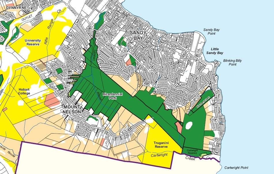
Bicentennial Park. Jill Hickie. Bushland Planner, Hobart City Council
|
|
|
- Janel Jordan
- 5 years ago
- Views:
Transcription


1 Bicentennial Park Jill Hickie Bushland Planner, Hobart City Council
2
3 Bushland Management Vision Statement The Council in partnership with the local community will retain, promote and enhance the unique character and values of Hobart s bushland for the long term environmental, social and economic benefit of the community.
4 Hobart bushland key objectives 1.Protection, enhancement and maintenance of biodiversity, geodiversity and cultural heritage values. 2.Maintenance and protection of watercourses and associated water quality measures contained within bushland areas. 3.Reduction of threatening processes, which are degrading, or which could degrade bushland values. 4.Restoration and rehabilitation of degraded bushland. 5.Encouraging community participation in managing bushland.
5 Hobart bushland key objectives 6. Improving community awareness of bushland values. 7. Facilitating public use for recreation and enjoyment of bushland compatible with conserving its natural and cultural values. 8. Working co-operatively with other agencies, community groups and individual landholders to manage bushland areas. 9. Recognising the strong link between Tasmania s Aboriginal people and Hobart s bushland values with inclusive management practices.
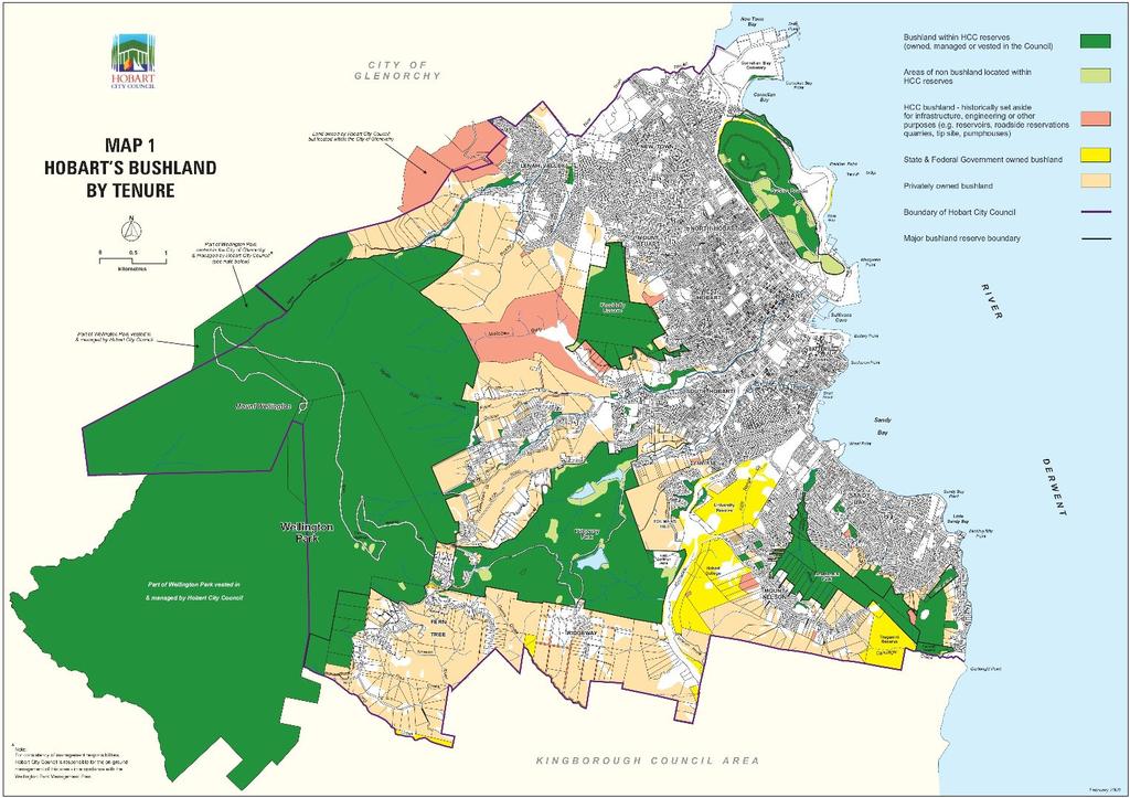
6 Bushland in Hobart Area of Hobart = 7790ha The Council has responsibility for managing 4589 hectares (ha) of bushland; 2966 ha within the municipal boundaries of Hobart, and 1623 ha outside of the Hobart City Council area. 173 hectares make up Bicentennial Park and Porter Hill.
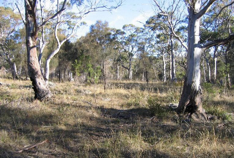
7
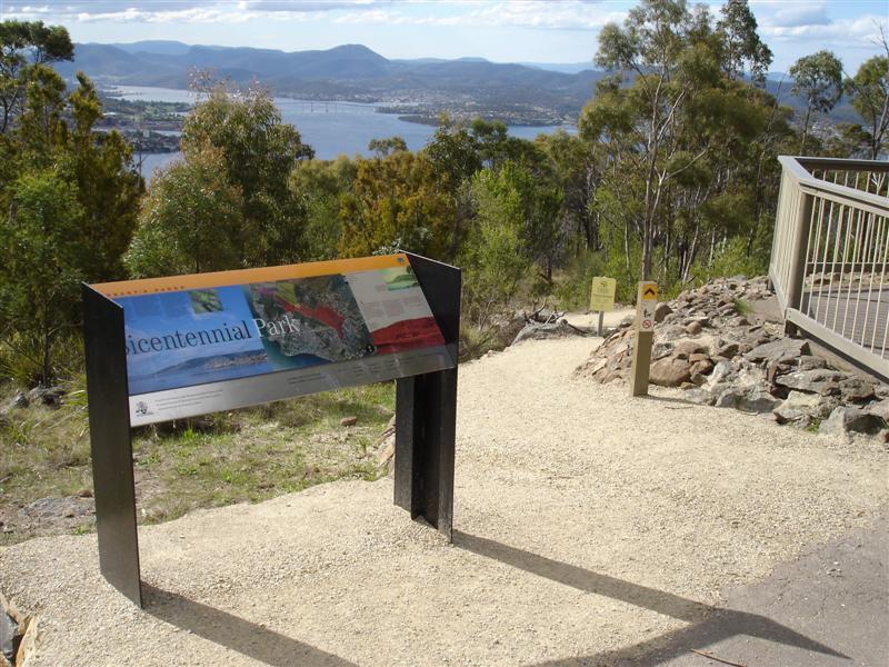
8 Bicentennial Park
9
10 Bicentennial Park History #1 Combined area of Bicentennial Park & Porter Hill =173 ha. Bicentennial Park includes: Old Skyline Reserve 68 ha Historic purchases, POS contributions, acquisitions over time Marlborough Street area 13 ha Donation from Catholic Church Nicholas Drive 9.36 ha Historic Council Reserve Enterprise Rd Signal Station 45 ha Acquired by Council for landscape protection with Aust Govt Bicentennial funds in 2003 Lower Porter Hill/FolderSt 7.2 ha Purchased by Council & Aust Govt National Reserve System
11 Bicentennial Park History #2 Porter Hill area includes: Residence & surrounds 4.3ha Bushland area 26.5.ha Purchased by Council & Aust Govt National Reserve System in 2006.
12 Bicentennial Park Basic references: HCC Lambert Park Skyline Reserve Management Plan (1998) HCC Lambert Park Skyline Reserve Fire Management Plan (1998) HCC Bicentennial Park Interim Management Guidelines (2005) North & Hird (2000) Porter Hill Proposed Fort Nelson Subdivision Assessment of Biological Values Sainty, R. (2205) A Survey for Aboriginal Heritage of Bicentennial Park
13 Bicentennial Park Interim BP management objectives: Preserve, protect and maintain the natural and cultural values of the area Provide for recreation opportunities consistent with protecting the natural and cultural values Control exotic flora and fauna in the area Protect persons and property from injury or damage by fire
14 Environmental values Flora - Plant communities Dry E. pulchella woodland (DPU) Dry grassy E. viminalis woodland (DVG) Allocasuarina verticillata forest (NAV) Dry E. globulus woodland (DGL) Wet E. globulus riparian corridors (DGL) Old improved pastureland A little bit of E. ovata forest (DOV)
15
16 Environmental values Threatened flora Lepidium pseudotasmanicum (Shade peppercress) Scleranthus fasciculatus (Spreading knawel) Vittadinia muelleri (Narrow lead New Holland Daisy Rhytidosporum procerum (Tall Wallaby Grass) Gahnia rodwayi (Rodways Saw sedge)
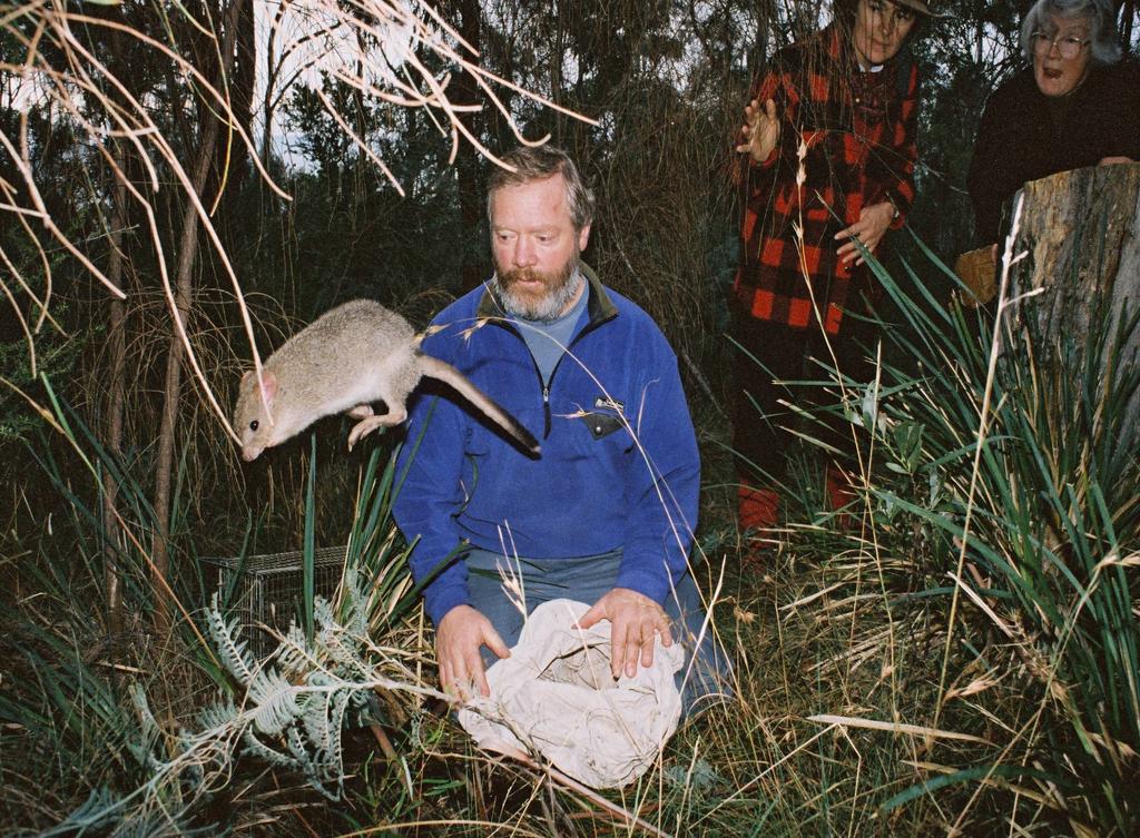
17 Environmental values Threatened fauna Lathamus discolor (Swift Parrot) Pardalotus quadragintus (40 spotted pardalote) Perameles gunnii (Eastern barred bandicoot) Tyto novaehollandiae (Masked owl)
18

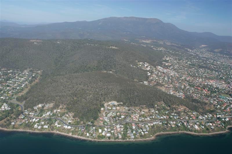
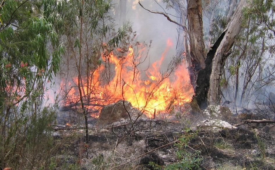
19 Landscape values
20
21 Recreational values Walking, mountain bike riding Tracks connecting Churchill Avenue to the Signal Station through to Truganini Reserve Fire trails open to mountain bikes
22 Heritage values Porter Hill- architecturally significant house Porter Hill- military heritage gun emplacement, barracks site Aboriginal heritage values AH surveys undertaken of both BP and PH have located no sites, but the landscape in itself may have been valued.
23 Reserve Neighbours Many residential blocks adjoin the Reserve Mount Nelson Signal Station and Truganini Reserve Tasmanian Parks and Wildlife.
24 Threats Weeds Wildfire Misuse Stormwater management Animal control Edge effects from surrounding development, including stormwater
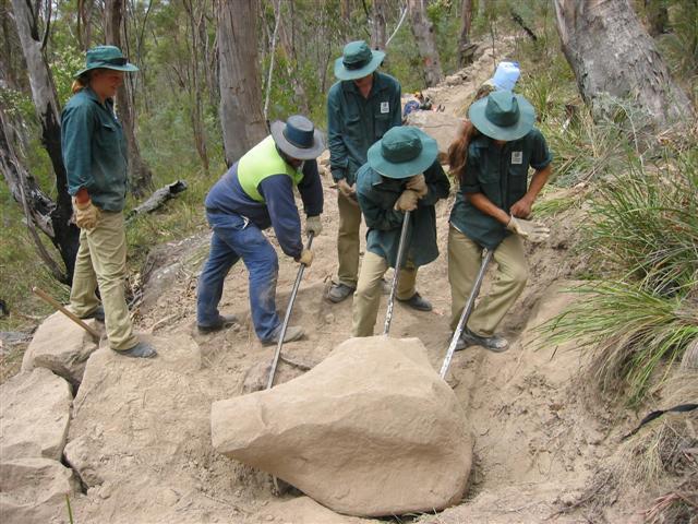
25 Weeds Most of the Hobart area usual suspects Woody weeds- boneseed, hawthorn, brooms, gorse, cotoneaster, mainland grevilleas, Spanish heath, radiata pine, blackberry Herbaceous weeds- banana passionfruit, clematis, pampas grass, thistles, introduced grasses, fennel, montbretia and all sorts of things escaping from people s gardens.
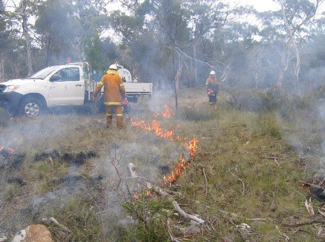
26 Wildfire risk management Dry vegetation communities are fire-promoting Fire Management Plan developed 1998, covered burning schedule, access and trails, pre- and postburn weed control, location and specs of firebreaks and other fuel reduced areas near susceptible assets Interim fire management measures implemented for land purchased post Fire Management Plan shortly to enter review phase, will include Bicentennial Park and Porter Hill.
27
28
29 Misuse Illegal clearing- firewood collection, views, extensions to firebreaks Encroachment- illegally fenced areas, gradual bed-by-bed creep of gardens further into bushland, car parking. Inappropriate recreational use - mountain bikes on walking tracks
30 Animal control Feral and pet cats Roaming dogs Dogs off lead in on-lead areas
31 Stormwater management Many outlets in steep areas- particularly Lambert Gully Erosion and downstream siltation problems High nutrient laden waters promotes weed invasion Litter and other noxious items washed into reserve
32 Bicentennial Park Management works undertaken since property purchases and acquisitions: Bicentennial Park New walking track from Enterprise Rd to Mt Nelson Signal Station Upgrading signage the main entry points Upgrading main fire trail from Enterprise Rd to Nelson Rd Maintenance of fire breaks Weed mapping & weed management works Fauna surveying Consultation with reserve neighbours regarding the change in land status and fire hazard issues Aboriginal heritage survey along the new walking track Porter Hill a range of studies investigating future options for the residence Extensive primary and secondary weed control Fire management
33
34 Questions?
Department of Environment, Climate Change & Water NSW. Stakeholder feedback
 Department of Environment, Climate Change & Water NSW Stakeholder feedback 1 Stakeholders group Blue Gum High Forest Group Guardians of Lane Cove NP Sydney Metropolitan Wildlife Service Ku-ring-gai Historical
A THRIVING ENVIRONMENTAL AND RECREATIONAL PRECINCT IN OUR SOUTHERN SUBURBS
 A THRIVING ENVIRONMENTAL AND RECREATIONAL PRECINCT IN OUR SOUTHERN SUBURBS A STRONG PLAN FOR REAL CHANGE 1 We re ready. Over the last four years, we ve been working hard developing our vision for the future
Land Management Summary
 photo credit: ANGAIR Anglesea Heath Land Management Summary The Anglesea Heath (6,501 ha) was incorporated into the Great Otway National Park in January 2018. This provides an opportunity to consider the
GLENTHORNE NATIONAL PARK OUR NEW BACKYARD
 2036 WILL MARK OUR STATE S BICENTENARY By the time our State turns 200 years old, I want South Australia to be a place of prosperity. Planning and delivering on my vision for a better future starts now.
Mimosa Creek Precinct Landscape Plan
 Mimosa Creek Precinct Landscape Plan Version 2.0 Prepared by: Michael Fox President Mt Gravatt Environment Group PO Box 5 Carina Qld 4152 www.megoutlook.wordpress.com Table of Contents 1 Purpose 2 2 Foundation
City of Hobart Bushfire Management Strategy 2014 Version 2.2. Endorsed by Council 22/9/2014. Hobart City Council, Hobart, 2014
 City of Hobart Bushfire Management Strategy 2014 City of Hobart Bushfire Management Strategy 2014 Version 2.2 Endorsed by Council 22/9/2014 Hobart City Council, Hobart, 2014 Hobart City Council 2014.
TOWPATH MOWING GUIDELINES
 TOWPATH MOWING GUIDELINES 24 September 2007 CONTENTS Introduction Scope and Status of Guidelines Influences on the Guidelines Health and Safety Biodiversity INTRODUCTION Towpath management is a key issue
NARRABEEN LAGOON SUMMIT am Wednesday, 13 April 2005 Warringah Council Chambers, 725 Pittwater Road, Dee Why.
 NARRABEEN LAGOON SUMMIT 9.15 9.30am Wednesday, 13 April 2005 Warringah Council Chambers, 725 Pittwater Road, Dee Why. NSW Minister for the Environment, the Hon. Bob Debus I am very pleased to be here to
Nov. 19 th Public Workshop Summary
 On November 19 th, more than 60 community members attended an Open Space Matters workshop at the Linen Building in downtown Boise for over two hours. Participants learned about reserves, discussed the
Andy Sharp Natural Resources Northern & Yorke. Brooke Liebelt Yorke Peninsula Tourism
 Andy Sharp Natural Resources Northern & Yorke Brooke Liebelt Yorke Peninsula Tourism Rewilding is about restoring natural processes, to: improve conservation outcomes improve the ecosystem services provided
Item 1 Ryhope Paper Subdivision
 Item 1 Ryhope Paper Subdivision Item 1 Ryhope Paper Subdivision Address (the site) 3, 5, 7,9 10-22, 24, 25, 28, 35-40, 42, 44, 46, 48 Charles Street, Ryhope 4, 6, 8, 10, 12, 14, 16, 18, 20, 22-28, 30,
Cumberland Land Conservancy Inc 2017 ABN PO Box 119 Plumpton NSW 2761
 - - - Cumberland Land Conservancy (CLC) is a volunteer operated not-for-profit charity dedicated to acquiring and managing land for conservation in perpetuity including education of the community to be
Western Australia The State of Islands
 Western Australia The State of Islands How many islands? There are c. 3700 islands off the coast of WA 2 estimates: 3424 (State), 3747 (Commonwealth) mainly continental islands in State waters, most managed
Lake Manchester RECREATION GUIDE. seqwater.com.au
 Lake Manchester RECREATION GUIDE seqwater.com.au About Lake Manchester OUR VISION To manage access to recreation opportunities while protecting natural resources and water quality. Lake Manchester is located
SHOREHAM FORESHORE RESERVE MANAGEMENT PLAN EXTRACT
 SHOREHAM FORESHORE RESERVE MANAGEMENT PLAN EXTRACT EXECUTIVE SUMMARY To protect the natural undeveloped character of the Reserve by conserving and enhancing indigenous flora and fauna whilst providing
MANAGEMENT DIRECTION STATEMENT June, 1999
 Thompson River District MANAGEMENT DIRECTION STATEMENT June, 1999 for Clearwater River Corridor (Addition to Wells Gray Park) Ministry of Environment Lands and Parks BC Parks Division ii Table of Contents
Energex Loganlea to Jimboomba Network Upgrade Response to Supplementary IAR. Closes 8 April Submission by
 Energex Loganlea to Jimboomba Network Upgrade Response to Supplementary IAR Closes 8 April 2010 Submission by Logan and Albert Conservation Association Prepared by Anne Page (BA Hons Dip Ed M Env Mgt)
STONE MOUNTAIN PROVINCIAL PARK Purpose Statement and Zoning Plan
 1 STONE MOUNTAIN PROVINCIAL PARK Purpose Statement and Zoning Plan Stone Mountain Provincial Park is situated 140 km west of Fort Nelson at Kilometre 595 of the Alaska Highway. The 25 690 ha park is located
Ewen Maddock Dam RECREATION GUIDE
 Ewen Maddock Dam RECREATION GUIDE seqwater.com.au About Ewen Maddock Dam OUR VISION To manage access to recreation opportunities while protecting natural resources and water quality. Ewen Maddock Dam,
Priority Species, Communities, Ecosystems, and Threats
 Priority Species, Communities, Ecosystems, and Threats East Gippsland Regional Catchment Strategy 2015/2016 1.0 Objective This document aims to assist in the preparation of project applications for 2015-2016
Fossil Creek Wild & Scenic River Comprehensive River Management Plan Forest Service Proposed Action - details March 28, 2011
 Fossil Creek Wild & Scenic River Comprehensive River Management Plan Forest Service Proposed Action - details March 28, 2011 Primary Goals of the Proposed Action 1. Maintain or enhance ORVs primarily by
Environment Levy Quarterly Report October-December 2016
 Environment Levy Quarterly Report October-December 2016 Welcome to the October December 2016 Quarterly Report for the Sunshine Coast Council s Environment Levy. The Environment Levy assists Council and
Lake Kurwongbah RECREATION GUIDE
 Lake Kurwongbah RECREATION GUIDE seqwater.com.au OUR VISION To manage access to recreation opportunities while protecting natural resources and water quality. About Lake Kurwongbah Lake Kurwongbah is located
A summary of Draft Makara Peak Mountain Bike Park Master Plan
 A summary of Draft Makara Peak Mountain Bike Park Master Plan OVEMBER 216 Image: Peter Marshall 2 3 Introduction Since it was established in 1998, the Makara Peak Mountain Bike Park (Makara Peak) has grown
Recreation Management Plan Lake Baroon and Ewen Maddock Dam
 Lake Baroon and Ewen Maddock Dam December 2013 Contents Overview... 3 The Value of Our Natural Areas... 4 Management Approach... 6 Funding... 7 Recreation Management... 8 Conditions of Access and Use...
Appendix 1: Best Management Practices For Hang Gliding and Paragliding in Jasper National Parks
 Appendix 1: Best Management Practices For Hang Gliding and Paragliding in Jasper National Parks Name of Best Management Practice Best Management Practices for Hang Gliding and Paragliding in Jasper National
Four Wheel Driving in the Sydney Region
 Four Wheel Driving in the Sydney Region Four Wheel Driving in the Sydney Region Four wheel driving is a great way to see parts of Australia that many people never get the chance to experience. Unfortunately,
Cooloolabin Dam RECREATION GUIDE. seqwater.com.au
 Cooloolabin Dam RECREATION GUIDE seqwater.com.au OUR VISION To manage access to recreation opportunities while protecting natural resources and water quality. About Cooloolabin Dam Cooloolabin Dam is located
A Diverse Economic Vision for the Tarkine Region:
 A Diverse Economic Vision for the Tarkine Region: The Tasmanian Greens Alternative $23M Tarkine National Park Funding Package Released by Nick McKim MP and Cassy O Connor MP March 2009 Wild Tarkine. Rob
Decision Memo for Desolation Trail: Mill D to Desolation Lake Trail Relocation
 for Salt Lake County, Utah Uinta-Wasatch-Cache National Forest Salt Lake Ranger District 1. Background The present location of the Desolation Trail (#1159) between Mill D and Desolation Lake follows old
As outlined in the Tatshenshini-Alsek Park Management Agreement, park management will:
 Management Strategy General Strategy The priority management focus for the park is to ensure that its internationally significant natural, cultural heritage and recreational values are protected and that
Welcome KROSNO CREEK DIVERSION PROJECT CLASS ENVIRONMENTAL ASSESSMENT
 Welcome KROSNO CREEK DIVERSION PROJECT PUBLIC INFORMATION CENTRE # 1 Tonight s Presentation Study Overview Background Existing Conditions Alternative Solutions Preliminary Preferred Solution Next Steps
MAIN LAKE PROVINCIAL PARK
 MAIN LAKE PROVINCIAL PARK PURPOSE STATEMENT AND ZONING PLAN March 2003 MAIN LAKE PROVINCIAL PARK Purpose Statement and Zoning Plan Primary Role The primary role of Main Lake Park is to protect a biologically
BELLHOUSE PROVINCIAL PARK
 BELLHOUSE PROVINCIAL PARK PURPOSE STATEMENT AND ZONING PLAN March 2003 1 BELLHOUSE PROVINCIAL PARK Purpose Statement and Zoning Plan Primary Role The primary role of Bellhouse Provincial Park is to protect
F.J. Martin Roberts Evening (Mt Coot-tha from Dutton Park) 1898
 1898") F.J. Martin Roberts Evening (Mt Coot-tha from Dutton Park) 1898 A Deed of Grant in Trust protecting Mt Coot-tha was enacted in 1880 after community pressure, the reserve to be managed as a public park
F.J. Martin Roberts Evening (Mt Coot-tha from Dutton Park) 1898 A Deed of Grant in Trust protecting Mt Coot-tha was enacted in 1880 after community pressure, the reserve to be managed as a public park
Lake Baroon RECREATION GUIDE
 Lake Baroon RECREATION GUIDE seqwater.com.au About Lake Baroon OUR VISION To manage access to recreation opportunities while protecting natural resources and water quality. Lake Baroon, located between
Barwon Coast Coastal Management Plan. 2012/13 to 2014/15
 Barwon Coast Coastal Management Plan 2012/13 to 2014/15 Table of contents 1. Introduction 3 1.1 Background 3 1.2 Statutory Arrangements 4 1.3 Vision 4 1.4 Purpose of the Plan 5 1.5 Policy Framework 5 1.6
The South Gippsland Koala. For over 60 years, the plantation industry has shared a unique relationship with the Strzelecki Koala. protection.
 The South Gippsland Koala For over 60 years, the plantation industry has shared a unique relationship with the Strzelecki Koala. protection harmony THE CO-EXISTENCE OF THE KOALA WITH THE PLANTATIONS co-existence
Hawke s Bay Regional Parks Network. Pekapeka Regional Park Individual Park Plan
 Hawke s Bay Regional Parks Network Pekapeka Regional Park Individual Park Plan 2015-2024 Hawke s Bay Regional Council 159 Dalton Street Private Bag 6006 Napier 4110 Hawke s Bay New Zealand Telephone: 0800
THOMAS A. SWIFT METROPARK Introductions History Present Conditions Future Development Plans Implementation Strategies Statistics
 THOMAS A. SWIFT METROPARK Introductions History Present Conditions Future Development Plans Implementation Strategies Statistics Introduction As an open meadow park positioned along the Mahoning River,
Yard Creek Provincial Park. Management Plan
 Yard Creek Provincial Park Management Plan Draft January 2010 Yard Creek Provincial Park Management Plan Approved by: telàlsemkin/siyam/chief Scott Benton Bill Williams Squamish Executive Director ation
Building a world leading protected area system for Queensland
 August 2018 Building a world leading protected area system for Queensland We welcome and support the Queensland Government s commitment to build a world-leading protected area system for Queensland. 1
ISLAND PARK MANAGEMENT PLAN AND GUIDELINES
 ISLAND PARK MANAGEMENT PLAN AND GUIDELINES - 2015 Introduction Island Park was a sand dune on the edge of Lake Huron 12,000 years ago. As the lake receded, it left a river channel, the Thunder Bay River.
5.0 OUTDOOR RECREATION OPPORTUNITIES AND MANAGEMENT
 5.0 OUTDOOR RECREATION OPPORTUNITIES AND MANAGEMENT 5.1 Introduction This section describes the range of recreational activities that currently take place in Marble Range and Edge Hills Parks, as well
TAIERI MOUTH RECREATION RESERVE MANAGEMENT PLAN
 CLUTHA DISTRICT COUNCIL TAIERI MOUTH RECREATION RESERVE MANAGEMENT PLAN 26 June 2003 CONTENTS Page 1 PREFACE... 1 2 INTRODUCTION... 2 2.1 Location of Reserve... 2 2.2 Legal Description... 2 2.3 Purpose
USDA Forest Service Deschutes National Forest DECISION MEMO. Round Lake Christian Camp Master Plan for Reconstruction and New Facilities
 USDA Forest Service Deschutes National Forest DECISION MEMO Round Lake Christian Camp Master Plan for Reconstruction and New Facilities Jefferson County, Oregon T. 13 S., R. 8 E., Section 16, W.M. Background:
Finn Creek Park. Management Direction Statement Amendment
 Finn Creek Park Management Direction Statement Amendment November 2013 Management Direction Statement Amendment Approved by: Jeff Leahy Regional Director, Thompson Cariboo BC Parks November 12, 2013 Date
The Conservation Contributions of Ecotourism Cassandra Wardle
 The Conservation Contributions of Ecotourism Cassandra Wardle PhD Candidate, Gold Coast, Australia Supervisors: Ralf Buckley, Aishath Shakeela and Guy Castley State of the Environment State of the Environment
Strategies and Land Release
 North West and South West Growth Centres Bruce Colman Precinct Project Manager 1 Growth Centres: Background Metropolitan Strategy North West & South West Rezone land quickly Planning and infrastructure
Caroona Coal Project. Gunnedah Coal Conference 20 September 2006
 Caroona Coal Project Gunnedah Coal Conference 20 September 2006 Exploration Licence History Authorisation 216 was originally granted on 9 May 1980. Expressions of Interest sort for a portion of A216 on
Welcome to the future of Terwillegar Park a Unique Natural Park
 Welcome to the future of Terwillegar Park a Unique Natural Park 1 Introduction The Terwillegar Park Concept Plan study will develop an overall concept plan, management objectives and development guidelines
Cooloolabin Dam Recreation Management Discussion Paper. November 2013
 Cooloolabin Dam Recreation Management Discussion Paper November 2013 Contents November 2013... 1 Background... 3 Overview of Cooloolabin Dam... 6 Weed Management... 7 Cultural Heritage... 7 Commercial
Trappist Monastery Provincial Park. Management Plan
 Trappist Monastery Provincial Park Management Plan 2 Trappist Monastery Provincial Park Table of Contents 1. Introduction... 3 2. Park History... 3 3. Park Attributes... 4 3.1 Natural... 4 3.2 Recreational...
Lake Burrumbeet Futures Project. Background Information
 January 2019 Overview The background information has been prepared by the Department of Environment, Land, Water and Planning (DELWP) on behalf of the - Project Partner Group. This report summarises emerging
National Forests and Grasslands in Texas
 United States Department of Agriculture Forest Service National Forests and Grasslands in Texas Sam Houston NF 394 FM 1375 West New Waverly, Texas 77358 Phone 936-344-6205 Dear Friends, File Code: 1950
PROTECTED AREAS ZONE - POLICY
 PROTECTED AREAS ZONE - POLICY.1 Introduction The Protected Areas Zone applies to the land depicted on the Ruapehu District Plan Maps as: Amenity Policy Area. Protected Areas - Conservation. (c) Protected
TRAVEL WITH CHRIS BROWN
 TRAVEL WITH CHRIS BROWN ARKABA STATION In South Australia's magnificent Flinders Ranges, one eco tourism company is doing their bit to protect native wildlife. Arkaba Station was once a sheep station but
Environment Levy Annual Report
 Environment Levy Annual Report 2014-2015 Message from the Mayor Your Environment Levy in action for 2014-2015 The Sunshine Coast is without question a unique and special place and our region s natural
SUMMER VILLAGE OF SILVER SANDS. Municipal Development Plan
 SUMMER VILLAGE OF SILVER SANDS Municipal Development Plan Bylaw 253-2014 Adopted August 22, 2014 Summer Village of Silver Sands Municipal Development Plan Bylaw No. 253-2014 Page 2 1 INTRODUCTION 1.1 SETTING
Sporting Shooters Association of Australia Victoria Ltd
 Sporting Shooters Association of Australia Victoria Ltd Submission to Parks Victoria Plenty Gorge Park Concept Plan Draft 2015 July 2015 Page 1 of 5 Table of Contents Recommendations... 2 About the Sporting
Let s Be Firewise! Here s how...
 Let s Be Firewise! Here s how... 4 3 1 5 2 1 The roof is most important in protecting my home! 2 Low A green lawn tells fire to Stay Away! 3 4 plants slow oncoming fire Stack wood pile away from home 5
MEELUP REGIONAL PARK ANNUAL REPORT
 MEELUP REGIONAL PARK ANNUAL REPORT 2015-2016 Contents 1. Introduction... 3 2. Meelup Regional Park Management Committee... 3 3. Staffing... 4 4. Presiding Member s report... 5 5. Key Achievements 2015/16...
Pembina Valley Provincial Park. Draft Management Plan
 Pembina Valley Provincial Park Draft Management Plan 2 Pembina Valley Provincial Park Table of Contents 1. Introduction... 3 2. Park History... 3 3. Park Attributes... 3 3.1 Natural... 3 3.2 Recreational...
Appendix 3. Greenway Design Standards. The Whitemarsh Township Greenway Plan
 Appendix 3 Greenway Design Standards This chapter discusses two design standards for the greenway types discussed above. First, trail design standards are presented together with trailhead facilities and
SHASTA WEST PLANNING AREA
 2016 SHASTA COUNTY COMMUNITY WILDFIRE PROTECTION PLAN SHASTA WEST PLANNING AREA Covering the communities of: Centerville Redding (west & downtown) Shasta I. PROPOSED PROJECTS A. THE PLANNING AREA SHASTA
CHAPTER 13 Tourism and Recreation. Kildare County Development Plan , Volume 1
 Chapter 6 Rural Housing Strategy CHAPTER 13 Tourism and Recreation 197 13 TOURISM AND RECREATION 13.1 Background 13.2 Goal Tourism is one of the growth sectors in our economy. Kildare is rich in natural
Lake Somerset RECREATION GUIDE
 Lake Somerset RECREATION GUIDE seqwater.com.au OUR VISION To manage access to recreation opportunities while protecting the natural resources and water quality About Lake Somerset Lake Somerset is located
The following criteria were used to identify Benchmark Areas:
 7.0 BENCHMARK AREAS The Churn Creek Protected Area offers a significant opportunity to learn more about how grassland ecosystems function. One of the key tools that will be used to monitor larger grassland
MANAGEMENT DIRECTION STATEMENT March 2003
 Skeena Region MAAGEMET DIRECTIO STATEMET March 2003 for Meziadin Lake Provincial Park Ministry of Water, Land and Air Protection Environmental Stewardsh Division This page left blank on purpose ii Table
MINIMUM REQUIREMENTS DECISION GUIDE WORKSHEETS
 ARTHUR CARHART NATIONAL WILDERNESS TRAINING CENTER MINIMUM REQUIREMENTS DECISION GUIDE WORKSHEETS Fuel Maintenance Around Red-cockaded Woodpecker Trees on Islands within the Okefenokee Wilderness Area....
Trappist Monastery Provincial Park. Draft Management Plan
 Trappist Monastery Provincial Park Draft Management Plan 2 Trappist Monastery Provincial Park Table of Contents 1. Introduction... 3 2. Park History... 3 3. Park Attributes... 3 3.1 Natural... 3 3.2 Recreational...
Update Report - Etobicoke Creek and South Mimico Creek Trails
 REPORT FOR ACTION Update Report - Etobicoke Creek and South Mimico Creek Trails Date: October 23, 2017 To: Etobicoke York Community Council From: General Manager, Parks Forestry and Recreation Wards: Ward
CONSTABLE CREEK LOILA TIER RESERVE A NEW PROTECTED AREA FOR NORTH EAST TASMANIA
 CONSTABLE CREEK LOILA TIER RESERVE A NEW PROTECTED AREA FOR NORTH EAST TASMANIA North East Bioregional Network July 2007 Contents Executive Summary 3 Recommendations 3 Reserve Area 4 Description of the
Lake Wivenhoe RECREATION GUIDE
 Lake Wivenhoe RECREATION GUIDE seqwater.com.au OUR VISION To manage access to recreation opportunities while protecting the natural resources and water quality About Lake Wivenhoe Lake Wivenhoe, located
OMINEACA PROVINCIAL PARK
 OMINEACA PROVINCIAL PARK AND PROTECTED AREA PURPOSE STATEMENT AND ZONING PLAN March 2003 OMINECA PROVINCIAL PARK AND PROTECTED AREA Purpose Statement and Zoning Plan Omineca Park and Omineca Protected
WALKER SWAMP INFORMATION DAY Saturday 23 rd June 2018
 WALKER SWAMP INFORMATION DAY Saturday 23 rd June 2018 Introduction to the Upper Wannon River Floodplain wetlands and the new Walker Swamp Restoration Reserve Mark Bachmann and Greg Kerr, Nature Glenelg
Designated Sites. Headlines
 Designated Sites Headlines Over 36% of the Sheffield district is covered by sites with European, national or local designation. These offer valuable habitats to wildlife, with some level of protection,
Outreach: Terrestrial Invasive Species And Recreational Pathways S U S A N B U R K S M N D N R I N V A S I V E S P P P R O G C O O R D
 Outreach: Terrestrial Invasive Species And Recreational Pathways S U S A N B U R K S M N D N R I N V A S I V E S P P P R O G C O O R D Education Project Funded by USFS State & Private Forestry Describe
Bloor Street West Rezoning Application for a Temporary Use By-law Final Report
 STAFF REPORT ACTION REQUIRED 3741 3751 Bloor Street West Rezoning Application for a Temporary Use By-law Final Report Date: June 12, 2007 To: From: Wards: Reference Number: Etobicoke York Community Council
Daisy Dean Trail 628/619 ATV Trail Construction
 Background and Purpose and Need The Daisy Dean ATV Trail Construction Project is located in the Little Belt Mountains, Musselshell Ranger District, Lewis and Clark National Forest approximately 32 miles
KOOTENAY LAKE PROVINCIAL PARK (MIDGE CREEK SITE)
") KOOTENAY LAKE PROVINCIAL PARK (MIDGE CREEK SITE) PURPOSE STATEMENT AND ZONING PLAN February 2003 Approved by: KOOTENAY LAKE PROVINCIAL PARK (Midge Creek Site) Purpose Statement and Zoning Plan Primary
KOOTENAY LAKE PROVINCIAL PARK (MIDGE CREEK SITE) PURPOSE STATEMENT AND ZONING PLAN February 2003 Approved by: KOOTENAY LAKE PROVINCIAL PARK (Midge Creek Site) Purpose Statement and Zoning Plan Primary
THUNDER HILL PROVINCIAL PARK
 THUNDER HILL PROVINCIAL PARK PURPOSE STATEMENT AND ZONING PLAN February 2003 Approved by: THUNDER HILL PROVINCIAL PARK Purpose Statement and Zoning Plan Primary Role The primary role of Thunder Hill Provincial
B10. Agate Beach State Recreation Site
 B10. Agate Beach State Recreation Site Location Within the City of Newport, just south of the Yaquina Head Outstanding Natural Area. The park is located along the west side of Highway 101 at the mouth
Ecological Corridors: Legal Framework for the Baekdu Daegan Mountain System (South Korea) Katie Miller* Kim Hyun**
 Katie Miller* Kim Hyun**") Ecological Corridors: Legal Framework for the Baekdu Daegan Mountain System (South Korea) Katie Miller* Kim Hyun** Information concerning the legal instruments discussed in this case study is current as
Ecological Corridors: Legal Framework for the Baekdu Daegan Mountain System (South Korea) Katie Miller* Kim Hyun** Information concerning the legal instruments discussed in this case study is current as
Nakina Moraine Provincial Park. Interim Management Statement. Ontario. Ministry of Natural Resources
 Nakina Moraine Provincial Park Interim Management Statement Ontario Ministry of Natural Resources 1999, Queen's Printer for Ontario Printed in Ontario, Canada Additional copies of this publication can
Appendix F Public authorities responses
 Planning Proposal under sec 55 of the EP&A Act LEP Refinements Appendix F Public authorities responses Appendix F Public authorities responses Prior to public exhibition, consultation was made with the
CHAPTER 3.6 Regional parks
 124 This section discusses how the ARC will look after the regional parks network, ensure that park users needs are met, plan for the purchase of new parkland, and undertake capital works on regional parks.
Beaver Creek Provincial Park. Management Plan
 Beaver Creek Provincial Park Management Plan 2 Beaver Creek Provincial Park Table of Contents 1. Introduction... 3 2. Park History... 3 3. Park Attributes... 4 3.1 Natural... 4 3.2 Recreational... 4 4.
 March 25, 1994 To: Re: MEMO TO FILE MINOR AMENDMENT - PINERY PROVINCIAL PARK MANAGEMENT PLAN The following paragraph from page 5 of the Pinery Provincial Park Management Plan (ISBN 0-7729-0290-9) lnsects
Global Sustainable Tourism Destinations Criteria
 Global Sustainable Tourism Destinations Criteria Draft destination level Global Sustainable Tourism Criteria as proposed after Destinations and International Standards joint working group meeting and follow-up
Bayview Escarpment. Interim Management Statement
 Bayview Escarpment Interim Management Statement Bayview Escarpment Provincial Nature Reserve Interim Management Statement January 15, 1995 REGIONAL DIRECTOR'S APPROVAL STATEMENT This Interim Management
Conservation Area Management Statement
 Conservation Area Management Statement Miller Creek Wildlife Area Resolution #: Approval: Issue Date: Date of Last Revision: Table of Contents 1. Purpose....... 1 2. Property Description...... 1 2.1. Legal
Establishing a National Urban Park in the Rouge Valley
 STAFF REPORT ACTION REQUIRED Establishing a National Urban Park in the Rouge Valley Date: March 29, 2012 To: From: Wards: Reference Number: Executive Committee Deputy City Manager, Cluster B All p:\2012\cluster
Land Management Update
 Tasmanian Aboriginal Centre Inc. Land Management Update Babel, Badger, Big Dog, Hummocky, lungtalanana, Preminghana, trawtha makuminya, piyura kitina/risdon Cove & putalina This is a quick overview of
MANAGEMENT DIRECTION STATEMENT June, 1999
 Thompson River District MANAGEMENT DIRECTION STATEMENT June, 1999 for Roche Lake Provincial Park Ministry of Environment Lands and Parks BC Parks Division Table of Contents I. Introduction A. Setting
Parkland County Municipal Development Plan Amendment Acheson Industrial Area Structure Plan
 Parkland County Municipal Development Plan Amendment Acheson Industrial Area Structure Plan New Plan Acheson Industrial Area Structure Plan Amendment Parkland County Municipal Development Plan Board Reference
Appendices A (Our ambition for nature (A3 plan) and further information)
 and further information)") Appendices A (Our ambition for nature (A3 plan) and further information) Penny Hill Farm Nature Conservation vision Key: Tenancy boundary Meadow restoration & Mowing/meadow F33 Mowing/meadow Progress towards
Appendices A (Our ambition for nature (A3 plan) and further information) Penny Hill Farm Nature Conservation vision Key: Tenancy boundary Meadow restoration & Mowing/meadow F33 Mowing/meadow Progress towards
Alternative 3 Prohibit Road Construction, Reconstruction, and Timber Harvest Except for Stewardship Purposes B Within Inventoried Roadless Areas
 Roadless Area Conservation FEIS Summary Table S-1. Comparison of Key Characteristics and Effects by Prohibition Alternative. The effects summarized in this table A would occur in inventoried roadless areas
Watchorn Provincial Park. Management Plan
 Watchorn Provincial Park Management Plan 2 Watchorn Provincial Park Table of Contents 1. Introduction... 3 2. Park History... 3 3. Park Attributes... 3 3.1 Natural... 4 3.2 Recreational... 4 3.3 Additional
Submission on the Tukituki Catchment Proposal: EPA reference numbers; NSP 13/ , NSP 13/ , NSP 13/ , NSP 13/02.
 Hutt Valley Tramping Club PO Box 30 883 LOWER HUTT 5045 Tukituki Catchment Proposal Environmental Protection Agency Private Bag 63 002 WELLINGTON 6140 29 July 2013 Submission on the Tukituki Catchment