Expedition to Kamchatka August 31 to September 14, 2000 with seedlist
|
|
|
- Joshua Goodwin
- 6 years ago
- Views:
Transcription

1 Expedition to Kamchatka August 31 to September 14, 2000 with seedlist Elisabeth Öberg, Bo Nilsson Arboretum Norr Box 4097 SE UMEÅ SWEDEN
2 Collection of plant material from Kamchatka Seed list The seeds listed below were collected on the Kamchatka peninsula between August 31 and September 14, The expedition was organized by Arboretum Norr, Umeå, Sweden together with the Komarov Botanical Institute, St. Petersburg and the Vladivostok Botanical Institute, Vladivostok, which arranged for permits to travel and collect in Kamchatka. This expedition was made possible by support from the Royal Swedish Academy of Agriculture and Forestry and from Arboretum Norr Foundation. Collectors: Elisabeth Öberg, Arboretum Norr, Umeå, Sweden Bo Nilsson, Swedish University of Agricultural Sciences, Umeå, Sweden Gennady Firsov, Komarov Botanic Institute, St. Petersburg, Russia Ludmila M. Pshennikova, Vladivostok Botanical Institute, Vladivostok, Russia Drivers: Alexander Novikov, Milkovo Nikolaij Aksinovitch, Elizovo In Kamchatka we travelled with a four-wheel drive, off-road truck. The drivers skill and local knowledge made it possible for us to find and reach the most interesting areas, possible to reach without helicopter. Depending on the weather we slept in the truck or in tents. The main purpose of this expedition was to supply Arboretum Norr and the Arboretum of Komarov Botanic Institute with a plant material, especially seed, of well-defined origin and Vladivostok Botanical Garden with herbarium material. Arboretum Norr, together with the Horticulture Section of the Swedish University of Agricultural Sciences in Umeå, is actively working to develop a plant material for ornamental use in northern Sweden and has been doing that since its establishment in The aim is both finding better provenances of species already in use and to find new species, which are adapted to the specific climatic- and light conditions in the north, 63 N - 67 N. Ornamental trees and shrubs used and sold in Sweden today are often not suited to grow in the north part of the country, as they almost always originate from the southern part of their natural distribution area or are cultivars developed for Holland, Denmark, Germany or England. Due to a bad year for tree seeds no seeds of Larix and Picea and only very few seeds of Pinus and Betula could be collected this year. On the whole it was difficult to find berries and fruit on anything, which was a much bigger problem for the local people than for us, as today s troublesome economic situation have made many people more dependent on what the forest can give. Vegetative propagation material was collected only on a very small scale due to relatively short time available and the fact that we stayed in the field during the whole trip. Only some cuttings within the genera Salix, Populus and Chosenia were collected. In the list the collection sites are indicated by letters A N which corresponds to the descriptions in the text and the map (Fig. 1). The first number is the seedlist number - the number to be used when ordering - the second number is Arboretum Norr s own registration number and the last one is the collection number. As the amount of seed is very limited we will use the old rule first come, first served. You can send in your orders to our address on the frontpage or by to: Elisabeth.Oberg@njv.slu.se Cover image: Volcano Ploskij Tolbachik, m. Photo E. Öberg,
3 Why Kamchatka? It is difficult to find a reliable woody plant material for northern Sweden with its cool summers, short growing season and low winter temperatures (often below C). Also the long-day conditions in the north of Scandinavia during the summer can cause problems especially in the end of the vegetation period. The fact that the climate in the north part of Sweden, say north of the latitude 64ºN, has continental features often with stable winters without warm periods, make it possible to use continental species. Plant material from Canada, continental North East Asia and Siberia can usually cope with low winter temperatures, but often demands higher temperatures during the summer season and a longer growth period to build up the essential amount of nutrients to survive the long winter. Kamchatka offers an interesting plant material, which is resistant to winter temperatures below -30 ºC, but also adapted to short growing season not more than 4,5 months and cool summers. The south and middle part of Kamchatka Peninsula is in fact situated beneath the 56ºN, which corresponds to Skåne in southern Sweden, so the plant material is not adapted to long-day conditions during the growing season. But to find an interesting plant material adapted to long-day growing conditions is almost impossible. Some facts about Kamchatka The Kamchatka Peninsula covers an area of about km 2, and the whole region (Kamchatka Oblast) about km 2. It is situated in the easternmost part of Siberia between the latitudes 51 N and 60 N and separated from the mainland by the Okhotsk Sea. The main city is Petropavlovsk-Kamchatskij, founded by Vitus Bering in 1740, have today about inhabitants. The total population of the oblast is nowadays (Foreign Investment Promotion Center, 1998) but prior to the collapse of the Soviet Union some people lived there (Hansson, 1995). In Petropavlovsk on the south-east coast the mean annual temperature is + 0,7 ºC, the same as in Kalix in the northernmost part of the Gulf of Bothnia (table 1.). The spring in Kamchatka often comes later compared with northern Sweden and the autumn is somewhat prolonged, especially along the coast. In the winter the cold ocean currants and iceberg on the east side and the totally frozen Okhotsk Sea on the west side delay the spring. The fact that large masses of water store warmth makes the season longer along the coast. In the inland of the peninsula the climate is more continental and the mean temperature lower. As a comparison, the north Swedish climate is dominated by westerly winds (cyclones) and depressions moving in from the Atlantic which gives the climate more maritime features. However, Sweden being on the western outskirts of a vast continent, the climate in its northeastern parts is more continental (Holmer, 1982) and seems to be comparable to the coastal climate of south Kamchatka (table 1). Table 1. The mean temperature in some places in Kamchatka (approx. 30 years) (Hansson, 1995). Mean of the years in three places in the north of Sweden (SMHI Meteorologi, 1991) Site Jan Feb Mar Apr May Jun Jul Aug Sept Oct Nov Dec Mean Esso (inland) -20,1-18,5-13,4-5,1 2,8 9,4 13,0 11,5 5,8-2,1-11,0-17,4-3,8 Petropavlovsk (coastal) -9,4-9,3-6,4-1,8 2,3 6,7 10,8 12,1 9,2 4,0-2,5-7,1 0,7 Gällivare -14,3-12,4-7,9-1,9 4,8 11,1 13,3 11,0 5,4-0,3-7,7-12,3-0,9 Kalix -13,1-11,8-7,2-0,4 6,2 12,5 14,9 12,9 7,7 2,1-4,8-10,3 0,7 Piteå -10,5-10,0-5,7-0,1 5,3 12,2 15,0 13,7 8,7 3,3-3,7-8,4 2,1 Volcanoes and seismic activity is characteristic of the Kamchatka peninsula. There is totally 160 volcanoes of which about 29 are active (Hansson, 1995) and numerous hot springs and geysirs. The Vostochnij Range (Eastern Range) is the most active mountain range with all active volcanoes except one. The largest and highest volcano is Klyuchevskaja Sopka 4750 m. a. s. l, the largest 3
4 active volcano in Eurasia, which most recently erupted in 1994 (Hansson, 1995). We visited the Plosky Tolbachik Volcanoe (3062 m), south of Klyuchevskaja, where one of the largest eruptions in the world took place during 1975 and 1976 and several new volcanoes were born. Large areas of forest were buried in layers of black ash and only Elymus, species of prostrate growing dwarf Salix and lichens have now begun to colonize the caldera. The vegetation contains of about 1170 species of vascular plants (Hansson, 1995). Approximately 100 of these are ligneous species of which five are conifers, Larix gmelinii var. japonica (Rgl.) Pilger (syn. Larix cajanderi Mayr.), Picea jezoensis (Sieb. et Zucc.) Carr, Pinus pumila(pall.) Regel, Juniperus communis var. saxatilis Pall. (syn. Juniperus sibirica Burgsd) and Abies gracilis (syn. Abies sibirica). When going north following the only road from Petopavlovsk you are travelling through almost entire birch forest dominated by Betula ermanii Cham. and with the white birch, Betula plathyphylla Sukaz., on lower altitude. It is strange not seeing one single coniferous tree, except thickets of Pinus pumila(pall.) Regel growing here and there on the steep slopes and as undergrowth as well as above the tree limit ( m a s l). Then suddenly just north of Milkovo (54º45 N), the larch appears and some 10 km north of that Picea jezoensis (Sieb. et Zucc.) Carr., the Yeddo spruce. The Kamchatka fir, Abies gracilis (syn. Abies sibirica), is restricted to a single, about 20 ha area large stand near the the Nikolsky Range not far from the east coast and said to be a relic from preglacial times. Some Russian botanists though find it very strange that it is limited to this only stand and have theories that the trees for some reason were planted. We decided not to visit the area as it was difficult to get there by lorry and we could not afford to rent a helicopter. Recently the five most important areas for protection were chosen and included in the UNESCO World Heritage checklist: Kronotskij Biosphere Reserve (Zapovednik), Yuzno-Kamchatskij Zakaznik, Yuzno-Kamchatskij Nature Park, Nalychevo Nature Park and Bystrinskij Nature Park. The five protected areas cover almost all types of ecosystems characteristic of Kamchatka and includes several of the most interesting volcanoes of the peninsula (E. Lobkov, 1999). Main collecting sites (see. map) A. Korjakskaja Sopka Volcano, m a s l, 53º16 N, 158º45 E. Alpine tundra with scattered thickets of Alnus fruticosa Rupr. and Pinus pumila (Pall.) Regel (up to 1060 m a s l ). The alder and pine reached 1 1,5 m height up to 1000 ma s l. Prostrate growing Salix-species were growing everywhere on dry gravel. Several species of Artemisia is growing almost directly in the pumice and volcanic gravel together with Dryas punctata Juz. In more sheltered places surrounded by the alder we found Ledum decumbens (Ait.) Lodd ex Stend. Vaccinium vitis-idaea L. ssp. minus (Lodd.) Hultén we found up to 1100 m. Rhododendron camtschaticum Pall. was growing on the southern slope up to 1060 m and Rhododendron aureum Georgi. to 1200 m. a. s. l. B. Avachinskij Volcanoe, m a s l, 53º15 N, 158º50 E. On the lower part of Avachinskij, facing north-west, the thickets of alder of about 1,5 m height were denser and more difficult to walk through, here a lot of Vaccinium uliginosum L., Vaccinium vitis-idaea L. ssp. minus (Lodd.) Hultén, Empetrum nigrum L., Phyllodoce caerulea (L.) Bab. and Spiraea betulifolia Pall. var. stevenii (Rydb.)Kom. were growing in open glades but the rhododendrons were lacking. Above 900 m almost all of the ligneous vegetation had disappeared because of the eruption in 1991 and we found only herbaceous perennials. A small stream was running between the two volcanoes created a small sediment plain where dense vegetation of alder was growing almost impossible to force. Here we found Aruncus dioicus (Walt.) Fern and on the south edge of the thickets Rhododendron aureum Georgi. 4


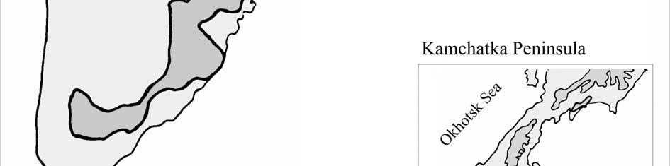
5 5 Figure 1. Map over the Kamchatka Peninsula with collecting sites A N.
6 C. On the way down from Korjakskaja Sopka 600 m a s l. Subalpine Betula ermanii-forest (Öberg E., Bäck J. 1995) near the treeline, on the shadowed side of a dried stream. D. On the Bistraja River plain, 150 km north of Petopavlovsk close to a summer fishing camp by the river. 290 m a s l, N, E. Moor-like vegetation with Rosa amblyotis C.A. Mey., Vaccinium uliginosum, the only cm heigh L., Lonicera caerulea var. edulis Regel (syn. Lonicera kamtschatica (Sevast.) Pojark) with very tasty berries and Spiraea sericea Turcz. and grasses, only a few scattered trees of Betula platyphylla Sukaz. and Salix. E. Near the main road Petropavlovsk - Ust-Kamtchatsk. 8 km north of Milkovo. 160 m a s l N, E. Microphyllous deciduous forest (Öberg E., Bäck J. 1995). Edge of the wood, old overgrown farmland with grass, high herbaceous perennials and scattered groups of white birch, Chosenia arbutifolia (Pall.) A. Skvorts, Sorbus kamtschatcensis Kom., Salix schweinii E.Wolf and Salix udensis Trautv. et Mey. F. Near the main road Petropavlovsk - Ust-Kamtchatsk km north of Milkovo. 150 m a s l N, E. Alluvial soils of the Kamtchatka River Plain. The beginning of the Light taiga (Öberg E., Bäck J. 1995) of mainly Larix gmelinii var. japonica (Rgl.) Pilger (syn. Larix cajanderi Mayr)., Betula platyphylla Sukaz. and few Picea jezoensis (Sieb. et Zucc.) Carr. G. Along the forest road between Kosyrevsk and volcano Ploskij Tolbachik m a s l N, E. Light taiga. Alluvial soils of the Kamtchatka River Plain. Larch, white birch and very large specimens of Populus maximowiczii A. Henry (syn. Populus komarovii Ja. Vassil. ex Worosch) (Charkevicz, 1995) with Pinus pumila (Pall.) Regel as main undergrowth. Along the road we saw some plantations with Pinus sylvestris L. As the larch forest is very light and not very dense a lot of shrubs and smaller trees can grow under its canopy: Prunus padus L., Lonicera caerulea var. edulis Regel, Juniperus communis L. var. saxatilis Pall., Sorbaria sorbifolia (L.) A. Br., Spiraea sericea Turcz., roses and a lot of Clematis ochotensis (Pall.) Poir. were climbing in the shrubs. H. On the southwest side of the volcano Ploskij Tolbachik. On the m a s l. 55º 46 N, 160º15 E. Pumice, black ash and volcanic rocks. Very dry ground. At 1090 m on the alpine tundra, vegetation only in spots (patches). Several prostrate growing Salix-species (e.g. Salix sphenophylla A. Skvorts.), Arctostaphylos alpina(l.)spreng., Rhododendron aureum and grasses. Here and there shrubberies of Pinus pumila along a steep bank of a stream. Just beyond the tree limit at 700 m a s l, alpine birch forest with Alnus fruticosa and high herbs as undergrowth. I. Western bank of the Kamchatka River near the ferrystation Krapivnaja. 40 m a s l, 55º55'N, 159º41'E. Alluvial soils on Kamtchatka River plain. Microphyllous deciduous forest of Sorbus aucuparia, Betula platyphylla, Populus maximowiczii and Salix udensis along the river, with high herbs as undergrowth. 6
7 J. Village No. 47 with hot springs and Spa, 10 km east of the village Anavgai. 280 m a s l. 56ºN, 159º05'E. Secondary forest of Betula platyphylla, Populus tremula L., Populus maximowiczii, Salix udensis Trautv. et Mey and S. schwerinii, rich herbaceous flora of Aconitum, Thalictrum, Actaea and Iris on overgrown moist farm land in the valley. At the edge of wood Sambucus kamtchatica. On the steep slopes around also secondary forest after felling the larch, mostly of Populus tremula and Populus maximowiczii with undergrowth of Pinus pumila and Alnus fruticosa the field layer here was poorer and consisted of Vaccinium vitis-idaea L., Ledum palustre L.. In the beautiful primary larch forest the undergrowth contained of Pinus pumila, Vaccinium uliginosum, Lonicera caerulea and Ledum palustre. K. Just south of Milkovo on the alluvial soils of the Kamtchatka river, in the lowland. 160 m a s l. 54º39'N,158º30'E On the edge of an open forest of Populus maximowiczii, Salix udensis and Chosenia arbutifolia in the lowland near the river. L. About 35 km north of the hot springs and wells in Malki, 5 km east of the main road m a s l. 53º30'N, 157º38'E. Primary Betula ermanii-forest with rich undergrowth of high herbs - Cimicifuga simplex (DC.) Wormsk ex Turcz., Filipendula camtschatica (Pall.) Maxim., Senecio cannabifolius Less., Cacalia hastata L. and shrubs Lonicera chamissoi Bunge ex P.Kar, Lonicera caerulea, Sorbus sambucifolia (Cham. et Schlecht) M. Roem and Daphne kamtschatica (Sevast.) Pojark. In dryer areas on small heights Juniperus communis and Pinus pumila. M. 1 km S of Malkina. On the bog around a small tarn in the Betula ermani forest. 280 m a s l. 53º18'N,157º29'E. Low bush vegetation of Betula nana ssp. exilis (Sukacz.) Hultén, Ledum palustre, Myrica tomentosa (DC.) Aschers et Graebn. and Chamaedaphne calyculata (L.) Moench. N. Between Apacha village and Nachikinskij pass 380 m a s l. 53º05'N, 157º48'E. Primary Betula ermanii-forest with rich undergrowth of high herbs Cypripedium yatabeanum Makino, Streptopus amplexifolius (L.) DC., Trollius riederianus Fisch. et May, Aruncus dioicus (Walt.) Fern, Cimicifuga simplex (DC.) Wormsk ex Turcz., Filipendula camtschatica (Pall.) Maxim., Senecio cannabifolia, Cacalia hastata and shrubs Lonicera chamissoi, Lonicera caerulea and Sorbus sambucifolia. Here we stopped to look for Vaccinium praestans Lamb. and on a north, shadowy very steep slope we found it. References Alexandersson H., Karlström C. & Larsson-McCann S Temperature and precipitation in Sweden , Reference normals. SMHI Meteorologi, 81. The Swedish Meteorological and Hydrological Institute, Norrköping, Sweden. (In Swedish; English summery) Belaya, G. A et. al Opredelitel sosudistih rastenij Kamchatskoi Oblasti (Key for Identification of Vascular plants of the Kamchatka Region in Russian). Moskow: NAUKA. 411p. Charkevicz, S.S. (ed.) Сосудистые растения советского дальнего востока (Vascular plants of the Soviet Far East in Russian). Tomus 7. NAUKA, Saint Petersburg. Charkevicz, S.S. (ed.) Сосудистые растения советского дальнего востока (Plantae Vasculares Orientis Extremi Sovietici- in Russian). Tomus 8. NAUKA, Saint Petersburg. Foreign Investment Promotion Center, Ministry of Economy of the Russian Federation Information about the Kamchatka Region. 7
8 Hansson, O. V The forest genetic resources of Kamchatka. Icel. Agr. Sci. 9, p Holmer Björn Några drag i Sveriges klimat. Göteborgs universitet, Naturgeografiska institutionen. (In Swedish) Hultén E., Flora of Kamchatka and the Adjacent Islands. Kungl. Svenska Vetenskapsakademiens Handlingar, Tredje Serien, Band 5, No.1. Stockholm. Lobkov. E Камчатка Обьекты Всемирного Природного Наследия (Sites of World Natural Heritage Kamchatka in Russian with summeries of each chapter in English). LOGATA, Moskow. Nedoluzhko, V. A Конспект дендрофлоры российского дальнего востока (Outlines to Dendroflora of Russian Far East - in Russian). DALNAUKA, Vladivostok. Öberg E., Bäck J A vegetation field study in Changbai Shan Manchuria. Arboretum Norr, Box 4097, Umeå, Sweden. 8
9 Kamtchatka 31 Aug - 13 Sept List of collected seeds No. ID no. Species Locality m. a. s. l. Coll. no Pinaceae Pinus pumila (Pall.) Regel A 1060 K Pinus pumila (Pall.) Regel B 1000 K30 Cupressaceae Juniperus communis L. (J. sibirica Burgsd.) D 290 K Juniperus communis L. (J. sibirica Burgsd.) G 320 K57 Apiaceae Bupleurum triradiatum Adams ex Hoffm. B 1100 K Heracleum dulce Fisch. C 600 K35 Asteraceae Achillea asiatica Serg. J 280 K Artemisia arctica Less. A 900 K Artemisia glomerata Ledeb. A 1060 K Artemisia glomerata Ledeb. B 1100 K Artemisia sp. A 1060 K Artemisia sp. A 1060 K Aster sibiricus L. A 870 K Cacalia hastata L. I 40 K Saussurea tilesii (Ledeb.) Ledeb. A 900 K Senecio cannabifolius Less. D 290 K Senecio cannabifolius Less. L 350 K75 Betulaceae Alnus fruticosa Rupr. A 870 K Alnus fruticosa Rupr. A 1060 K Betula ermanii Cham. L 350 K Betula nana subsp. exilis (Sukacz.) Hultén M 280 K Betula platyphylla Sukaz. J 280 K63 Caprifoliaceae Lonicera chamissoi Bunge ex P.Kar L 400 K Lonicera kamtschatica (Sevast.) Pojark D 290 K Lonicera kamtschatica (Sevast.) Pojark J 100 K Sambucus kamtschatica E. Wolf E 160 K43 Convallariaceae Streptopus amplexifolius (L.) DC. N 380 K86 Ericaceae Chamaedaphne calyculata (L.) Moench M 280 K Ledum decumbens (Ait.) Lodd ex Stend. A 1060 K Loiseleuria procumbens (L.) Desv. A 1200 K Rhododendron aureum Georgi. A 900 K Rhododendron aureum Georgi. A 1100 K Rhododendron aureum Georgi. A 1200 K Rhododendron aureum Georgi. B 900 K Rhododendron aureum Georgi. H 1090 K Rhododendron camtschaticum Pall. A 900 K Rhododendron camtschaticum Pall. A 1060 K Vaccinium praestans Lamb. N 340 K Vaccinium uliginosum L. D 290 K Vaccinium vitis-idaea ssp. minus (Lodd.) Hultén A 900 K Vaccinium vitis-idaea ssp. minus (Lodd.) Hultén B 1000 K31 1
10 No. ID no. Species Locality m. a. s. l. Coll. no Gentianaceae Gentiana algida Pall. A 900 K7 Geraniaceae Geranium erianthum DC. L 400 K80 Iridaceae Iris setosa Pall. ex Link J 280 K Iris setosa Pall. ex Link L 400 K81 Myricaceae Myrica tomentosa (DC.) Aschers et Graebn. M 280 K82 Papaveraceae Papaver microcarpum D.C. B 1100 K29 Polemoniaceae Polemonium boreale Adams. H 1090 K51 Ranunculaceae Aconitum fischerii Reichenb. J 280 K Aconitum maximum Pall. ex DC. J 280 K Actaea erythrocarpa Fisch. J 280 K Cimicifuga simplex (DC.) Wormsk ex Turcz. L 400 K Clematis ochotensis (Pall.) Poir. G 300 K Thalictrum contortum L. (enl.??) trol. Thalictrum J 280 K66 aquilegifolium L. var. sibiricum Regel et Tiling Thalictrum minus L. ssp. thunbergii (DC.) Worosch J 280 K Trollius riederianus Fisch. et May N 380 K87 Rosaceae Aruncus dioicus (Walt.) Fern B 900 K Aruncus dioicus (Walt.) Fern N 380 K Crataegus chlorosarca Maxim. E 160 K Filipendula camtschatica (Pall.) Maxim. L 350 K Potentilla fruticosa L. G 530 K Prunus padus L. G 320 K Rosa acicularis Lindl. G 530 K Rosa amblyotis C.A. Mey. C 400 K Rosa amblyotis C.A. Mey. I 40 K Rubus arcticus L. J 280 K Rubus sachalinensis Levl. J 280 K Sanguisorba officinalis L. A 960 K Sanguisorba tenuifolia Fisch. ex Link D 290 K Sibbaldia procumbens L. B 900 K Sorbaria sorbifolia (L.) A. Br. G 300 K Sorbus kamtschatcensis Kom. (Sorbus sibirica Hedl.) H 700 K Sorbus sambucifolia (Cham. et Schlecht) M. Roem L 400 K Spiraea salicifolia L. E 160 K Spiraea salicifolia L. G 300 K Spiraea media Schmidt (Spiraea sericea Turcz.) J 40 K Spiraea media Schmidt (Spiraea sericea Turcz.) D 290 K Spiraea betulifolia Pall. var. stevenii (Rydb.)Kom. (Spiraea stevenii (Schneid.) Rydb.) A 1060 K19 Salicaceae Salix sp. A 870 K Salix sp. (ev. arctica Pall.) B 1100 K Salix sphenophylla A. Skvorts. B 900 K Salix sphenophylla A. Skvorts. A 900 K9 2
11 No. ID no. Species Locality m. a. s. l. Coll. no Saxifragaceae Ribes pallidiflorum Pojark. (Ev. R. triste Pall.) G 350 K Ribes pallidiflorum Pojark. (Ev. R. triste Pall.) H 700 K52 Scrophulariaceae Lagotis glauca Gaertn. A 960 K Pennelianthus frutescens (Lamb.) Crosswhite (syn. Penstemon frutescens Lamb.) A 870 K11 Thymelaeaceae Daphne kamtschatica (Sevast.) Pojark J 280 K Daphne kamtschatica (Sevast.) Pojark L 400 K77 Note: We support the Convention on Biological Diversity. The seeds offered are for the use of the common good in the areas of research and development of public gardens and plant collections. They should not be used for commercial profit. If publications result from the use of this material, we expect acknowledgement as the source of the material and an unsolicited reprint of any publication. Elisabeth Öberg, director Arboretum Norr, Sweden Bo Nilsson, professor, Swedish University of Agricultural Sciences, Umeå, Sweden Gennady Firsov, curator, Komarov Botanic Institute, St. Petersburg, Russia Ludmila M. Pshennikova, curator, Vladivostok Botanical Institute, Vladivostok, Russia 3
APPENDIX A Data Sheets and Sample Site Photographs
 APPENDIX A Data Sheets and Sample Site Photographs Appendix C - Page 41 Seward Highway MP 99-105 Anchorage August 8, 2006 DOT&PF 1 RAC/EMC none none Southcentral Alaska N N N N N N Hydrology - the winter
Dendroflora of the Commander Islands, Russia Olga Mochalova, Gennady Firsov
 Shrubby vegetation along Bujan River on Bering Island. Dendroflora of the Commander Islands, Russia Olga Mochalova, Gennady Firsov photograph Gennady Firsov The Commander Islands are the western group
Vegetation and natural habitats of Kamchatka
 Ber. d. Reinh.-Tüxen-Ges. 20, 195-218. Hannover 2008 Vegetation and natural habitats of Kamchatka - Pavel V. Krestov & Alexander M. Omelko,Vladivostok & Yukito Nakamura, Tokyo - Abstract Since 2002 we
Label your Map with Russia. Map Activity
 Bell Activity How many time zones does the U.S. have? How do these time zones affect life in the U.S.? Russia is so large it has 11 time zones. What difficulties might this create? Objectives Know landforms,
GEOGRAPHY AND HISTORY
 GEOGRAPHY AND HISTORY YEAR 1, PART 1 www.vicensvives.es Contents 01 Our planet Earth 02 The representation of the Earth: maps 03 The Earth s relief 04 Rivers and seas 05 Weather and climate 06 Climates
Tree Availability for Spring 2018 as of March 27, 2018 bonnersferrynursery.com "The best friend on earth of man is the tree." - Frank Lloyd Wright
 Tree Availability for Spring 2018 as of March 27, 2018 bonnersferrynursery.com "The best friend on earth of man is the tree." - Frank Lloyd Wright Conifers Abies concolor Concolor Fir - zones 3-7 Abies
Chapter 14. The Physical Geography of Russia
 Chapter 14 The Physical Geography of Russia Chapter Objectives Identify the physical features and natural resources of Russia. Discuss the effects of Russia s climate and vegetation on life in the region.
NON TIMBER FOREST PRODUCTS IN KOSOVO
 UNMIK MINISTRY OF AGRICULTURE, FORESTRY AND RURAL DEVELOPMENT PISG NON TIMBER FOREST PRODUCTS IN KOSOVO November 2007, Dresden Kosovo in brief The total surface area is 1.1 million ha. Kosovo is circled
CH. 1 Europe and Russia: Physical Geography. Section 1 Land and Water p Europe and Russia are part of the world s largest landmass called.
 CH. 1 Europe and Russia: Physical Geography Section 1 Land and Water p.10-16 Europe and Russia are part of the world s largest landmass called. The country of Russia stretches over both continents. About
EXPLORING BIOMES IN GORONGOSA NATIONAL PARK
 EXPLORING BIOMES IN GORONGOSA NATIONAL PARK ABOUT THIS WORKSHEET This worksheet complements the Click and Learn Gorongosa National Park Interactive Map (http://www.hhmi.org/biointeractive/gorongosa-national-park-interactive-map),
Chapter 2A: The Russian Realm
 Geography: Realms, Regions, and Concepts 16 th Edition Chapter 2A: The Russian Realm The Russian Realm Two transition zones mark the margins. The Russian Realm Two transition zones mark the margins. Physical
Colorado Life Zone Scavenger Hunt
 Colorado Life Zone Scavenger Hunt Below are worksheets created for all the habitats or life zones. They were designed with the intention of breaking the class up into small groups, and having students
Map of Forested Habitats in Anchorage s Parks and Greenbelts
 Map of Forested Habitats in Anchorage s Parks and Greenbelts Susan C. Klein Alaska Natural Heritage Program Environment and Natural Resources Institute University of Alaska Anchorage June 1999 Funding
Ep156 Miller's Grove (2.3 ha) TL
 TL") Ep156 Miller's Grove (2.3 ha) TL 520040 Miller's Grove is located just within the extreme eastern boundary of Ongar Great Park, a medieval deer park dating from the 11 th century. This broadleaved woodland
Ep156 Miller's Grove (2.3 ha) TL 520040 Miller's Grove is located just within the extreme eastern boundary of Ongar Great Park, a medieval deer park dating from the 11 th century. This broadleaved woodland
January 2018 Air Traffic Activity Summary
 January 2018 Air Traffic Activity Summary Jan-2018 Jan-2017 CY-2018 CY-2017 Passengers 528,947 505,421 4.7% 528,947 505,421 4.7% Passengers 537,332 515,787 4.2% 537,332 515,787 4.2% Passengers 1,066,279
The Geological Pacific Northwest. Wednesday February 6, 2012 Pacific Northwest History Mr. Rice
 The Geological Pacific Northwest Wednesday February 6, 2012 Pacific Northwest History Mr. Rice 1 Free Response #2 Please do not simply list the items for this response. Full sentences!!! Minimum of 3-5
MORE THAN TRAVEL TAILOR- MADE TOURS TO RUSSIA
 SPECIAL OFFER FOR KAMCHATKA TREKKING TOLBACHIK VOLCANO 15.07 27.07 MORE THAN TRAVEL TAILOR- MADE TOURS TO RUSSIA Your personal Consultant: @discovussia.com +61 2831 0 7667 13 days in total, 10 days of
Flora Distribution Types and Migration of the Flora
 Flora The evolution of the flora and vegetation started at the end of the late glacial period, about 12,000 years BP (Before Present). The mountains became covered by sparse pine and birch woodlands and
WINTER CITY DESIGN GUIDELINES
 WINTER CITY DESIGN GUIDELINES February 2000 Table of Contents 1 Introduction: Winter and the Liveable City... 1 2 Winter Safety and Comfort... 1 3 Fort St-John s Climate... 2 4 Liveable Cities... 3 5 Key
Chapter 17. North Africa, Southwest Asia and Central Asia
 Chapter 17 North Africa, Southwest Asia and Central Asia Chapter Objectives Describe the major landforms and natural resources of North Africa, Southwest Asia, and Central Asia. Discuss the climate and
KAMCHATKA: NATURE S TOUR DE FORCE 12 JUL 2018
 KAMCHATKA: NATURE S TOUR DE FORCE 12 JUL 2018 OVERVIEW Tour Date: 12 July 2018 31 July 2018 Tour Duration: 19 days Tour Cost ($AUD): $16,950 Single Supplement ($AUD): $2,270 Closed to the outside world
Combined tour to Kamchatka
 The land of active volcanoes Combined tour to Kamchatka The blue of the Avachinsky Bay and the "dead forest" covered with ashes, geysers pouring from the bowels of the earth and volcanoes rising to the
Location, Climate, & Natural Resources
 Location, Climate, & Natural Resources UK is a country of islands off the coast of mainland Europe. It consists of England, Northern Ireland, Scotland, & Wales. UK s location makes it a HUB for trade.
2.1 What is the climate like?
 José Medeiros This fact sheet allows you to see how varied the countryside is across Brazil. 2.1 What is the climate like? Most of Brazil is in the Southern Hemisphere, where the seasons are the opposite
TYPE REGION P-j: SWII~TOKRZYSKIE MTS. (HOLY CROSS MTS.)
") ACTA PALAEOBOTANICA 2g (2) : 51-55, 1g39 KAZIMIERZ SZCZEPANEK TYPE REGION P-j: SWIITOKRZYSKIE MTS. (HOLY CROSS MTS.) Location: longitude c. 2 17'21 17'E, latitude c. 5 4'-51 34'N. Area: approx. 35 sq.
ACTA PALAEOBOTANICA 2g (2) : 51-55, 1g39 KAZIMIERZ SZCZEPANEK TYPE REGION P-j: SWIITOKRZYSKIE MTS. (HOLY CROSS MTS.) Location: longitude c. 2 17'21 17'E, latitude c. 5 4'-51 34'N. Area: approx. 35 sq.
DENMARK. CHAPTER TWELVE Section Two. DENMARK and ICELAND DENICE. Greenland too!
 CHAPTER TWELVE Section Two and ICELAND DENICE Greenland too! KEY QUESTION The success of Denmark can be traced to its' relationship with Europe. Explain Population: 5,325,000 Size: 16,638 sq. miles
STUDY GUIDE. The Land. Chapter 29, Section 1. Both. Terms to Know DRAWING FROM EXPERIENCE ORGANIZING YOUR THOUGHTS
 Chapter 29, Section 1 For use with textbook pages 719 724. The Land Terms to Know cordilleras Parallel mountain ranges and plateaus (page 719) archipelago A group of islands (page 720) insular Relating
STUDY GUIDE. The Land. Physical Features of Latin America. Chapter 8, Section 1. Terms to Know DRAWING FROM EXPERIENCE ORGANIZING YOUR THOUGHTS
 For use with textbook pages 193 198. The Land Terms to Know cordillera A mountain range that runs parallel to another mountain range (page 194) altiplano A high plain (page 194) escarpment A steep cliff
Mackinnon Esker Ecological Reserve Draft - Management Plan
 Mackinnon Esker Ecological Reserve Draft - Management Plan May 2011 Photo Credit: This document replaces the direction provided in the Carp Lake Provincial Park and Protected Area and Mackinnon Esker Ecological
調査報告. (Japanese Journal of Conservation Ecology) 17 : (2012)
 17 : (2012)") (Japanese Journal of Conservation Ecology) 17 : 263-269 (2012) 調査報告 1 2 1 2 2 Monitoring of bumblebee assemblages in the alpine zone of Daisetsuzan National Park Gaku Kudo 1 and Tetsuo Imoto 2 1 Faculty
(Japanese Journal of Conservation Ecology) 17 : 263-269 (2012) 調査報告 1 2 1 2 2 Monitoring of bumblebee assemblages in the alpine zone of Daisetsuzan National Park Gaku Kudo 1 and Tetsuo Imoto 2 1 Faculty
1 An Outline of Europe s Alpine Areas
 1 An Outline of Europe s Alpine Areas G. Grabherr, L. Nagy and D.B.A. Thompson Geographers, biologists, meteorologists, mountaineers and a large range of other groups of people each have their views on
Boreal Forested Glacial Ablation Plain Biophysical Setting Interior Alaska
 Boreal Forested Glacial Ablation Plain Biophysical Setting Interior Alaska Conservation Status Rank: S4 (apparently secure) Introduction Forested glacial ablation plains are represented by mature trees
KAMCHATKA: NATURE S TOUR DE FORCE 16 JUL 2017
 KAMCHATKA: NATURE S TOUR DE FORCE 16 JUL 2017 OVERVIEW Tour Date: 16 July 2017 3 August 2017 Tour Duration: 19 days Tour Cost ($AUD): $16,950 Single Supplement ($AUD): $2,270 Closed to the outside world
ALAGNAK WILD RIVER & KATMAI NATIONAL PARK VASCULAR PLANT INVENTORY ANNUAL TECHNICAL REPORT
 ALAGNAK WILD RIVER & KATMAI NATIONAL PARK VASCULAR PLANT INVENTORY ANNUAL TECHNICAL REPORT Matthew L. Carlson & Robert Lipkin Alaska Natural Heritage Program Environment and Natural Resources Institute
Idaho Native Plant Society 2018 Annual Meeting
 Idaho Native Plant Society 2018 Annual Meeting Hosted by: Calypso Chapter, Idaho Native Plant Society, Coeur d Alene, Idaho Dates: Friday thru Monday, June 29 thru July 2, 2018 Meeting Location: US Forest
Location, Climate, & Natural Resources Brain Wrinkles
 Location, Climate, & Natural Resources Standards SS6G10 The student will explain the impact of location, climate, natural resources, and population distribution on Europe. a. Compare how the location,
Chapter Objectives. Describe the dominant landforms and natural resources of Southeast Asia. Discuss Southeast Asia s climate and vegetation.
 Chapter Objectives Describe the dominant landforms and natural resources of Southeast Asia. Discuss Southeast Asia s climate and vegetation. The Land Section 1 Objectives Describe how tectonic plates and
The Geography of Climate
 The Geography of Climate Objective for Today: Today we will examine ways that latitude and landforms influence climate The focus of our study will be the South American Continent in the Formal Region known
Chapter 20. The Physical Geography of Africa South of the Sahara
 Chapter 20 The Physical Geography of Africa South of the Sahara Chapter Objectives Identify the major landforms, water systems, and natural resources of Africa south of the Sahara. Describe the relationship
International Russulales Workshop 2018
 International Russulales Workshop 2018 Borgsjö, Sweden August 26 th September 1 st 2018 Organization committee: Hjördis Lundmark Jan-Olof Tedebrand Birgitta Wasstorp Annemieke Verbeken Slavomír Adamčík
OUR EUROPE - NORTHERN EUROPE
 OUR EUROPE - NORTHERN EUROPE Europe is a small continent. People live very close to each other. More than seven hundred million people live here. Europe consists of almost fifty countries. More than half
Physical Geography of Europe. Chapters 13-18
 Physical Geography of Europe Chapters 13-18 The British Isles Archipelago made of 6000+ small islands Temperate climate Largest body of fresh water is Loch Ness Mostly rolling hills and large flat lands
Steep increases in overnight stays and revenue
 Tourism Activity October 2016 December,15 th 2016 Steep increases in overnight stays and revenue Hotel establishments recorded 1.8 million guests and 5.0 million overnight stays in October 2016, figures
Pied Thrush Report on Habitat and Sighting Areas Seejan Gyawali, Nils Peter Siemonsen, Raj Gurung
 Pied Thrush Report on Habitat and Sighting Areas Seejan Gyawali, Nils Peter Siemonsen, Raj Gurung Fig. 1: Pied Thrush (Zoothera wardii) (male), Photo by Seejan Gyawali Abstract: A Pied thrush (Zoothera
Terms to Know. artesian well coral atoll krill lagoon
 Chapter Objectives Describe the diverse landforms and natural resources of Australia, Oceania, and Antarctica. Discuss the wide range of climates and vegetation throughout the region. The Land Section
South Texas Plains. Texas, Our Texas
 South Texas Plains This is a region characterized by considerable variety. Climatically, the South Texas Plains region is sub-humid to dry. The in the north part of the South Texas, erosion of the Edwards
EUROPEAN COMMISSION DG XI.D.2. COUNCIL DIRECTIVE 79/409/EEC on the conservation of wild birds. and
 EUROPEAN COMMISSION DG XI.D.2 COUNCIL DIRECTIVE 79/409/EEC on the conservation of wild birds and COUNCIL DIRECTIVE 92/43/EEC on the conservation of natural habitats and of wild fauna and flora STANDARD
Current conditions. Guatemala's Maya Biosphere Reserve. No clear idea of speed of deforestation. Deforestion by pollen analysis
 Current conditions Most obvious human transformation is cutting of forests Guatemala's Maya Biosphere Reserve An Eco-Friendly Adventure Along the Maya Trails Key ecological roles: repository for biodiversity
Potomac Gorge. Resource Booklet. A Natural Monument in the Shadow of National Monuments. Bridging the Watershed. Potomac Gorge 75
 Potomac Gorge Potomac Gorge A Natural Monument in the Shadow of National Monuments Resource Booklet Bridging the Watershed An outreach program of the Alice Ferguson Foundation in partnership with the National
The Impact of Human Activities on Plant diversity in Nanda Devi Biosphere Reserve, West Himalaya, India
 The Impact of Human Activities on Plant diversity in Nanda Devi Biosphere Reserve, West Himalaya, India 1. INTRODUCTION Biosphere Reserves are the areas having rich ecosystem which are nominated by National
Glaciers. Chapter 17
 Glaciers Chapter 17 Vocabulary 1. Glacier 2. Snowfield 3. Firn 4. Alpine glacier 5. Continental glacier 6. Basal slip 7. Internal plastic flow 8. Crevasses 9. Glacial grooves 10. Ice shelves 11. Icebergs
MARKET NEWSLETTER No 57 January 2012
 OVERVIEW OF INTRA-EUROPEAN UNION TRADING BETWEEN 2007/08 AND 2010/11 The data on intra-eu trade reported in this month s newsletter have been taken from the EUROSTAT database. However, it is important
Volcano Above the Clouds
 Volcano Above the Clouds PROGRAM OVERVIEW NOVA joins climbers scaling Mount Kilimanjaro as they travel through ecosystems ranging from a cloud forest to a glaciated mountaintop. The program: chronicles
CONVENTION ON THE CONSERVATION OF EUROPEAN WILDLIFE AND NATURAL HABITATS. Standing Committee. 38 th meeting Strasbourg, November 2018
 Strasbourg, 29 October 2018 T-PVS/PA (2018) 20 [pa20e_2018.doc] CONVENTION ON THE CONSERVATION OF EUROPEAN WILDLIFE AND NATURAL HABITATS Standing Committee 38 th meeting Strasbourg, 27-30 November 2018
Water quality management in the Lake Baikal region of Russia
 Lomonosov Moscow State University Faculty of Geography Department of Environmental Management Water quality management in the Lake Baikal region of Russia Dr., Prof. Sergey Kirillov Dr., Prof. Mikhail
middle left: Riversleigh fossils lower left: Constance Range images: Hj Preuss... Thx
 Upstreampaddle Summer 2008 18 middle left: Riversleigh fossils lower left: Constance Range images: Hj Preuss... Thx top right: road west of the Isa middle right: Constance Range lower right: rocky outcrop
Residents ensure increase on overnight stays in hotels and similar establishments
 13 July 2018 Tourism Activity May 2018 Residents ensure increase on overnight stays in hotels and similar establishments Hotels and similar establishments registered 2.0 million guests and 5.4 million
Kronotskii Biosphere Reserve, Ryabikov Street, Elizovo, Kamchatka, , Russia
 The Eight North American Caribou Workshop, Whitehorse, Yukon, Canada, 20-24 April, 1998. Conservation of wild reindeer in Kamchatka Vladimir I. Mosolov Kronotskii Biosphere Reserve, Ryabikov Street, Elizovo,
The Ice Season
 The Ice Season 2006-2007 Author: Jouni Vainio 1 Co-authors: Simo Kalliosaari 1, Natalija Schmelzer 2, Torbjörn Grafström 3, Giedrius Ezerskis 4, Evgeni Komissarov 5, P. Soloshchuk 5, N. Fedorenko 5 and
Mountains in a Changing Climate - a journey through time and space on Getryggen
 Mountains in a Changing Climate - a journey through time and space on Getryggen Mountains in a Changing Climate - a journey through time and space on Getryggen Photo: Lisa Öberg, 21 May 2010. Getryggen.
Annual Weather Book RECORDED BY NW RESEARCH & OUTREACH CTR. By: Michael Leiseth
 Annual Weather Book RECORDED BY NW RESEARCH & OUTREACH CTR. By: Michael Leiseth Table I II 1 2 3 4 5 6 7 8 9, 10 11, 12 13, 14 15, 16 17 18 An average year in Crookston, MN. Seasonal extremes in Crookston,
Labrador - Island Transmission Link Target Rare Plant Survey Locations
 27-28- Figure: 36 of 55 29-28- Figure: 37 of 55 29- Figure: 38 of 55 #* Figure: 39 of 55 30- - east side Figure: 40 of 55 31- Figure: 41 of 55 31- Figure: 42 of 55 32- - secondary Figure: 43 of 55 32-
Agriculture, water mismanagement and ecosystem transformations in the Cuatrociénegas Valley in the Chihuahuan Desert, Mexico
 Agriculture, water mismanagement and ecosystem transformations in the Cuatrociénegas Valley in the Chihuahuan Desert, Mexico Irene Pisanty María Cristina Pérez y Sosa Gabriel Gálvez Departamento de Ecología
April 20, RG = Restoration Grade LQ = Low Quantity
 April 20, 2017 RG = Restoration Grade LQ = Low Quantity Latin Name Common Name Format Zone Size Price Note Evergreen Trees Abies fraseri Fraser Fir 1 Gallon 30cm $ 8.00 Juniperus virginiana Red Cedar 1
Siberian Institute for Ecological Initiatives Institute for the Environment UNC-Chapel Hill
 Siberia Siberian Institute for Ecological Initiatives Institute for the Environment UNC-Chapel Hill Dr. Pavel Barsukov Institute for Soil Science and Agrochemistry Siberian Institute for Ecological Initiatives
Sweden. Swedish Visitors in Finland Statistical Trends and Profile
 Sweden M A R K E T R E V I E W 2 0 1 5 Swedish Visitors in Finland Statistical Trends and Profile 26.10.2016 STATISTICS ON SWEDISH TOURISM IN FINLAND STATISTICAL TRENDS 3 Registered overnights 4 Number
MCGRAW-HILL EUROPE. Chapter 11 Physical Geography Pages 332 to 341
 MCGRAW-HILL EUROPE Chapter 11 Physical Geography Pages 332 to 341 Countries of Western Europe Benelux Countries UK, France, Luxembourg, Germany, Netherlands, Belgium, Austria, Switzerland, Belgium, Monaco,
Economy 3. This region s economy was based on agriculture. 4. This region produced items such as textiles, iron, and ships in great quantities. For th
 Geography 1. This region has a climate of warm summers and snowy cold winters. 2. This region has a climate that is generally warm and sunny, with long, hot, humid summers, and mild winters, and heavy
Pacific Forested Glacial Ablation Plain Biophysical Setting Southern Alaska
 Pacific Forested Glacial Ablation Plain Biophysical Setting Southern Alaska Conservation Status Rank: S4 (apparently secure) Introduction Forested glacial ablation plains are represented by mature trees
Mackinnon Esker Ecological Reserve. Management Plan
 Mackinnon Esker Ecological Reserve Management Plan March 2017 Cover Page Photo Credit: Rob Bell This document replaces the direction provided in the Carp Lake Provincial Park and Protected Area and Mackinnon
Supplementary report on project
 Supplementary report on project 15010-1 Status of populations of rare plant species on the Kunashir Island It is clear that detailed knowledge of species range and state of their populations is necessary
The ice season
 The ice season 2007-2008 Author: Jouni Vainio 1 Co-authors: Patrick Eriksson 1, Natalija Schmelzer 2, Anette Jönsson 3, Giedrius Ezerskis 4, Polina Soloshchuk 5, Natalia Fedorenko 5 and Yuriy Shiskin 6
Agenda. City of Ocean Shores City Council Study Session. Monday August 8, :00 PM
 Agenda City of Ocean Shores City Council Study Session Monday August 8, 2011 1:00 PM Ocean Shores Convention Center 120 Chance A La Mer Ocean Shores, Washington Call to Order Discussion 1. Weatherwax Wetland
The Role of Modeling in the Innovation of Sustainable Cassava Production. Department of Agriculture and Chiangmai University
 The Role of Modeling in the Innovation of Sustainable Cassava Production Department of Agriculture and Chiangmai University Radiation YIELD HYPOTHESIS Precipitation CO 2 + O 2 Temperature Soil Nutrient
1. Landforms. The Boreal Shield. Location The Boreal Shield can be found from Alberta to Newfoundland, between the Taiga Shield and the Boreal Plains.
 The Boreal Shield Location The Boreal Shield can be found from Alberta to Newfoundland, between the Taiga Shield and the Boreal Plains. 1. Landforms Rolling hills Exposed bedrock Evidence of glacial weathering
DIXIE HIGHWAY Region of Peel NAI Area # 1304, 1320, 2449, 2625, 3961
 DIXIE HIGHWAY 407 1 Region of Peel NAI Area # 1304, 1320, 2449, 2625, 3961 Toronto and Region Conservation Authority City of Brampton Size: 36 hectares Watershed: Etobicoke Creek Con 4 E, Lots 13, 14 Ownership:
Managemen t Plan for the World Natural H eri tag
 Managemen t Plan for the World Natural H eri tag De c em ber 20 09 Ministry of the Environ Forestry Agency Agency for Cultural Aff Hokkaido Government T a b l e o f C o n t e n t s 1. I n t r o d u c t
The Montane ecosystems: Characteristics and conservation Esther I. Njiro University of Nairobi, Institute of African Studies 1997
 The Montane ecosystems: Characteristics and conservation Esther I. Njiro University of Nairobi, Institute of African Studies 1997 enjiro@agi.uct.ac.za Keywords: mountains, conservation, vegetation zones,
Kagoshima Prefecture consists of about 600
 Kawai, K., Terada, R. and Kuwahara, S. (eds): The Islands of Kagoshima Kagoshima University Research Center for the Pacific Islands, 15 March 213 Chapter 16 Sugarcane Cultivation in the Islands of Kagoshima
Nordic/ECPGR Joint Workshop
 Nordic/ECPGR Joint Workshop THE CURRENT SITUATION OF CWR IN ALBANIA ALBAN IBRALIU AGRICULTURAL UNIVERSITY OF TIRANA 19-22 September 2016, Vilnius, Lithuania Albania 2 Population (2015): 4.000 000 Area
IRRIGATION IN AGRICULTURE AND CLIMATE CHANGE. Agrotech, 2017
 IRRIGATION IN AGRICULTURE AND CLIMATE CHANGE Agrotech, 217 Legislation Current situation Needs, possibilities, existing and potential problems Irrigation is regulated with the Water Law, and when it comes
ICPAC. IGAD Climate Prediction and Applications Centre Monthly Bulletin, February 2017
 IGAD CLIMATE PREDICTION AND APPLICATIONS CENTRE ICPAC Bulletin Issue March 2017 Issue Number: ICPAC/02/299 IGAD Climate Prediction and Applications Centre Monthly Bulletin, February 2017 For referencing
Kluane National Park and Reserve parkscanada.gc.ca. Bringing you Canada s natural and historic treasures. Photo : S. McDougall
 Kluane National Park and Reserve parkscanada.gc.ca Alsek River Camping & Travel Bringing you Canada s natural and historic treasures Photo : S. McDougall Table of Contents Introduction Background Campsite
A catchment approach to Himalayan Balsam control. Chris Jackson
 A catchment approach to Himalayan Balsam control Chris Jackson What are Invasive Non-native Species? Convention of Biological Diversity States that INNS are one of the top threats to international biodiversity
Kluane National Park and Reserve parkscanada.gc.ca. Bringing you Canada s natural and historic treasures. Photo : S. McDougall
 Kluane National Park and Reserve parkscanada.gc.ca Alsek River Camping & Travel Bringing you Canada s natural and historic treasures Photo : S. McDougall Table of Contents Introduction 3 Background Campsite
What Is An Ecoregion?
 Ecoregions of Texas What Is An Ecoregion? Ecoregion a major ecosystem with distinctive geography, characteristic plants and animals, and ecosystems that receives uniform solar radiation and moisture Sometimes
Belgium. Belgian Visitors in Finland Statistical Trends and Profile
 Belgium M A R K E T R E V I E W 2 0 1 5 Belgian Visitors in Finland Statistical Trends and Profile 24.10.2016 STATISTICS ON BELGIAN TOURISM IN FINLAND STATISTICAL TRENDS 3 Registered overnights 4 Number
SPAIN OVERVIEW MARESME BARCELONA VALENCIA MADRID SITGES VALENCIA COSTA BRAVA MARBELLA- COSTA DEL SOL IBIZA MARKET OVERVIEW AND FORECAST FOR 2017
 SPAIN OVERVIEW BARCELONA MARESME VALENCIA SITGES MADRID VALENCIA COSTA BRAVA MARBELLA- COSTA DEL SOL IBIZA MARKET OVERVIEW AND FORECAST FOR 217 38 LUCAS FOX / REAL ESTATE MARKET 216 / VALENCIA VALENCIA:
Distribution of Mangroves along the Red Sea Coast of the Arabian Peninsula: Part 2. The Southern Coast of Western Saudi Arabia
 Distribution of Mangroves along the Red Sea Coast of the Arabian Peninsula: Part 2. The Southern Coast of Western Saudi Arabia M. Asif Khan, Arun Kumar*and Abdul Muqtadir Center for Petroleum and Minerals,
Alpine Krummholz. Summary. Protection Not listed in New York State, not listed federally. Rarity G3G4, S2
 Alpine Krummholz Alpine krummholz on Mount Dix System Subsystem Terrestrial Barrens And Woodlands Did you know? The word krummholz is derived from German word krumm, meaning crooked, bent, or twisted;
2010 International Year of Biodiversity
 Royal Belgian Institute of Natural Sciences 2010 International Year of Biodiversity www.biodiv2010.be The International Year of Biodiversity Theme adopted by United Nations in 2007 Why 2010? Evaluation
COURSE DATES & PRICES 2019 NORTH AMERICA
 COURSE DATES & PRICES 2019 NORTH AMERICA SANTA MONICA SHORT TERM - CUT DURATION DAYS OF THE WEEK START DATES ABC CUT 1 5 DAYS MONDAY - FRIDAY Jan 7, 14 Feb 4, 18 Mar 4, 11 Apr 1, 15, 22 May 6, 20 Jun 3,
COURSE DATES & PRICES 2019 NORTH AMERICA
 COURSE DATES & PRICES 2019 NORTH AMERICA SANTA MONICA SHORT TERM - CUT DURATION DAYS OF THE WEEK START DATES ABC CUT 1 5 DAYS MONDAY - FRIDAY Jan 7, 14 Feb 4, 18 Mar 4, 11 Apr 1, 15, 22 May 6, 20 Jun 3,
Hydrology Input for West Souris River IWMP
 Hydrology Input for West Souris River IWMP Prepared by: Mark Lee Manitoba Water Stewardship 1 1 1 Overall view of: drainage area watershed characteristics gauging stations meteorological stations Runoff
Last eruption was in 1909.
 Teide National Park Where is it?: El Teide is a giant volcano, that occupies the island of Tenerife, whose coasts are bathed by the Atlantic Ocean. It is in the Canary Islands, off the northwest coast
Robson Valley Avalanche Tract Mapping Project
 Robson Valley Avalanche Tract Mapping Project Prepared for: Chris Ritchie Ministry of Water Land and Air Protection 325 1011 4th Avenue Prince George, BC. V2L3H9 and Dale Seip Ministry of Forests 1011
Unit 1: Physical Environment Glaciated Landscapes
 Unit 1: Physical Environment Glaciated Landscapes Corries Corries are bowl-shaped hollows high up in the mountains. They are formed in the following way: Snow collects in a hollow on a mountainside (usually
3rd GRADE MINIMUM CONTENTS UDI 1: LANDSCAPES (5)
") 3rd GRADE MINIMUM CONTENTS UDI 1: LANDSCAPES (5) DIFFERENT LANDSCAPES A landscape is all the things that we see in a place. There are different types of landscapes. Mountain landscapes have mountains and
3rd GRADE MINIMUM CONTENTS UDI 1: LANDSCAPES (5) DIFFERENT LANDSCAPES A landscape is all the things that we see in a place. There are different types of landscapes. Mountain landscapes have mountains and
Sabourin lake biodiversity reserve
 PLAN OF THE PROPOSED SABOURIN LAKE BIODIVERSITY RESERVE AND CONSERVATION PLAN FOR THE RESERVE (provisional name) Sabourin lake biodiversity reserve February 2003 March 2003 1 1. Plan and description 1.1.
The NESCAUM Method of Estimating Aircraft Emissions
 The NESCAUM Method of Estimating Aircraft Emissions Presentation to the OTC Mobile Source Committee December 5, 2001 Baltimore-Washington International Airport Ingrid Ulbrich Environmental Analyst NESCAUM