Kluane National Park and Reserve parkscanada.gc.ca. Bringing you Canada s natural and historic treasures. Photo : S. McDougall
|
|
|
- Elwin Blankenship
- 6 years ago
- Views:
Transcription


1 Kluane National Park and Reserve parkscanada.gc.ca Alsek River Camping & Travel Bringing you Canada s natural and historic treasures Photo : S. McDougall


2 Table of Contents Introduction 3 Background Campsite Restrictions Restricted use between Serpentine Creek & Lowell Lake 4 5 Bears Why is the Alsek River so important to bears? Some bear basics - what they eat Grizzly habitats and foods Bear safety Reporting bear incidents and observations 11 Appendix Risk assessments of designated camping areas and campsites between Serpentine Creek and Lowell Lake 20 2


3 Introduction The information provided in this pamphlet has been compiled to assist you in having a safe and enjoyable trip on the Alsek River. Many of the guidelines and regulations presented here are based on research fi ndings from grizzly bear ecology studies in Kluane National Park & Reserve. As travellers on the Alsek River you will be sharing prime bear habitat with the grizzlies and black bears in the valley. Understanding bear behaviour and ecology, and managing your activities appropriately, will minimize the chance of displacing bears or experiencing negative bear-human interactions during your trip. Photo : K. McLaughlin Your actions may ultimately affect whether healthy populations of bears are maintained in Kluane. This is a key management goal for the park. We hope you take your role in assisting us seriously. Read the information below and if you have any questions, do not hesitate to call us for more details before you arrive. 3

4 Background To many people, the existence of grizzly bears indicates a true wilderness setting. Tragically, wilderness areas are rapidly disappearing in North America and with them, the grizzlies. Human encroachment into wilderness settings has resulted in a tremendous loss of grizzly bear habitat and an increased number of human caused grizzly bear deaths. Parks Canada recognizes the signifi cance of protecting wilderness in Kluane National Park for grizzly bears and their habitat. The maintenance of a healthy bear population is one of the park s main management objectives. Public safety is also a concern. As such, it is important to reduce the potential for bear-human confl icts in the park, thereby, increasing the safety of both bears and people. The Alsek River corridor represents a large portion of the important habitat available to black bears and grizzly bears in Kluane. To help in the protection of grizzly bears and their habitat, the upper portion of the Alsek River (from the confl uence of the Kaskawulsh and Dezadeash rivers to Lowell Lake) has been designated a Special Preservation Area (see map). Complicating this situation, is the fact that the popularity of the Alsek River has increased dramatically since the early 1990 s. Managing human activities and minimizing human impacts that may cause displacement and/or mortality of bears in this portion of the Alsek River, will be important in meeting Kluane National Park s management objectives. Visitor access and activities within this area are controlled through special camping and travel restrictions, as a result. Photo : H. Markides 4
: a. Camping is restricted to designated campsites and/or camping areas (see Table1). g.")

 is not encouraged due to the risk of bear-human encounters and the possible disturbance to bears.")
5 Alsek River Campsite Restrictions Between Serpentine Creek and Lowell Lake To reduce the potential for bearhuman encounters and displacement of bears from important habitats the following restrictions are in effect within the Special Preservation Area (see Map): a. Camping is restricted to designated campsites and/or camping areas (see Table1). g. Bear resistant food canisters and/or portable electric fences are highly recommended and encouraged to help prevent bears from accessing human food. h. Firearms are prohibited in Kluane National Park & Reserve. Explanations of these restrictions follow: b. Camping between the confl uence of the Kaskawulsh and Dezadeash Rivers and campsite # 9 above Lowell Lake is limited to one night only per group per trip. c. Camping at all other sites is limited to one night except for Lowell Lake at which a maximum of two nights is permitted. d. Camping is prohibited in the Goatherd Mountain closure area and is limited to the eastern edge of Lowell Lake. e. Off river travel (e.g. day hikes) is not encouraged due to the risk of bear-human encounters and the possible disturbance to bears. f. It is mandatory to ensure your food and garbage is not accessible to bears. (see food storage) Photo : L. Gorecki Photo : A. Chilibeck Photo : K. McLaughlin 5
6 Table 1. Designated campsites between Serpentine Creek and Lowell Lake along the Alsek River, Kluane National Park, Yukon. 1 Campsite # General Description/Location 1 Serpentine Creek 2 Point of peninsula 3 4 Small point in bay before Beachview North side of Beachview Fan 5 Above Lava Creek 6 Lava Rocks 7 Lava Creek 8 Marble Creek (d/s) 9 Above Lowell Lake 10 Lowell Lake 11 Lowell Lake UTM (Zone 8) (NAD 27) Easting/Northing Side of River 2 Potential for Bear/ Human Encounter Potential for Displacement of Bears / RR Low Low / RL Low Low / RL Low-Mod Low-Mod / RL Mod Mod / RR Low Low / RL Low-Mod Low-Mod / RR Low-Mod Low-Mod / RR Low-Mod Low-Mod / RR Low-Mod Mod / RL Low Low-Mod / RL Low Low-Mod 1 Designated campsites have been assessed as having low, low to moderate or moderate potential for bear/human encounters and possible displacement of bears from their habitat. Use of campsites rated as low or moderate-low potential for encounters is recommended. The designated campsites locations were chosen and assessed on the following factors: evidence of previous use by river travellers; the abundance of bear food plants available; the abundance/frequency of bear sign such as scats, mark trees, trails and beds; features that reduce the ability of bears and people to detect each other (thick vegetation, prevailing winds, and noise from creeks, wind); and geographic features which infl uence the travelling patterns of bears (constriction in terrain, gullies etc.). 2 RR = river right, RL = river left (looking downstream) 6


7 a) Designated Camping To minimize the effects of river travel on normal bear activity, the movements of river users should be as predictable as possible. Bears are able to adjust their activities to avoid humans based on predictable behaviour. Some predictability may be accomplished by having regularly spaced departures and by having rafters use designated campsites. The regular use of designated campsites will make it easier for bears to adjust to human activities, but it also may raise other concerns that need to be considered. Some bears may become habituated to the regular presence of humans and therefore become bolder in their activities around these sites. This may increase the risk of bear-human encounters. For this reason, bear interactions with humans must be reported (refer to Reporting Bear Incidents). In addition, human food and garbage scents may become more prevalent at these sites through regular use and due to careless handling of food and garbage. This could potentially attract habituated bears into the campsites to investigate scents. For this reason, campsites with lower potential for bear-human encounters or bear displacement have been identifi ed and designated for use. Where possible, cooking areas should be located on the active fl oodplain so that they are periodically fl ooded and cleaned of lingering scents. Proper handling and storage of food and garbage are essential to the success of any human-bear confl ict program. Photo : L. Gorecki 7

8 Important Points Regarding Designated Campsites All designated campsites have the potential for bear-human encounters and displacement of bears. Read the materials provided so that you can reduce risk to yourself and the bears that you will encounter. Only designated campsites were assessed for the potential risk of bear-human encounters and displacement of bears. Other potential campsites within designated camping areas may have a higher risk for negative bear-human confl icts. Campsites hazard ratings are relative to other campsites assessed. High quality grizzly bear habitat is found along the entire length of the Alsek Valley. The river edge is also an important travel corridor for bears. Major game trails parallel both sides of the river. These trails are used regularly by bears, and in many cases trails pass close to designated campsites. Designated campsites have alternative travel routes around the area for bears to move if they detect the campsite is occupied. Camp in the open as far away as possible from trails and features that limit visibility. The benefi ts of designated camping can only be achieved if bears do not learn that human food and garbage can be Photo : S. McDougall obtained from campsites. Store food and garbage appropriately. Campsite designation may change if changes in bear behaviour at designated campsites occur, problems with bears develop, or lower risk alternatives are assessed. 8


9 b) One Night Restriction The goal of the one night restriction between the confl uence of the Kaskawulsh and Dezadeash Rivers and campsite # 9 above Lowell Lake is to minimize the number of people in the Special Preservation Area at any one time, and thus reduce human caused displacement of bears. c) Goatherd Mountain Closure Area The base of Goatherd Mountain is a major travel route for bears moving past Lowell Lake. Use of this area has a high potential for encounters and for the displacement bears. Bear movement is funnelled through open non-vegetated terrain along the base of a steep mountain face. Camping outside the closure area, and minimizing your length of stay at Lowell Lake, will help to reduce the long-term human impacts on bears. d) Off River Travel Campsite hazard ratings do not take hiking into consideration. Off river travel (such as day hikes) is not encouraged in the Special Preservation Area, for the same reasons mentioned above. e) Food Storage Bears are opportunistic and quick to learn. As they become habituated to people, the potential for bears to obtain human food and garbage increases. Food-conditioned bears are dangerous. If human food and garbage are not secured from bears, it is only a matter of time before foodconditioned bears become a threat to human safety. Photo : H. Markides 9

10 The Alsek River corridor will only continue to be a wilderness area, free of food conditioned bears, by preventing bears from accessing your food and garbage. This is your responsibility as a river user. These simple steps will help: keep your campsite clean and leave it clean when you leave; never leave your campsite, boats, or food unattended; and use bear resistant containers and/or portable electric fences to secure food and garbage. Preventing bears from accessing human food or garbage requires extra effort. As a river user, this may be the most important thing you can do to prevent the demise of the grizzly bear populations in this region and increase your personal safety. Remember: It is mandatory to ensure that human food and garbage is secured or contained in such a manner that it is inaccessible to bears (e.g. bear resistant containers; electric fences etc.). f) Electric Fences Portable electric fences have proven to be successful in helping to deter bears from camp areas. For more information on obtaining a fence or recommendations on their use, please contact the Kluane Resource Conservations at prior to arriving for your trip. g) Firearms Firearms are not allowed in Kluane National Park and Reserve. Note: Commercial chemical bear deterrent sprays are available. They should only be used as a last resort. Their effectiveness varies and is dependent upon correct use. Carrying bear deterrent spray should not replace common sense and proper travel precautions. If you would not feel comfortable travelling in an area without bear spray (or a gun e.g. outside the park), you should seriously consider not travelling in the area at all. Bear spray cannot replace your skills and knowledge. Photo : A. Chilibeck 10
11 BEARS 1. Why is the Alsek River so Important to Bears? The Alsek River valley is home to both grizzly and black bears. The valley is well used by both species throughout their active period (April - October). Plants used by bears in the spring, summer and fall are abundant and widespread along the valley bottom where you will be travelling. Peak bear use of the valley bottom, in the Special Preservation Area, occurs during the rafting season. Well-used game trails and an abundance of marked trees are evidence that the valley bottom serves as an important travel corridor for bears. 2. Some of the Bear Basics- What They Eat Like humans, grizzly and black bears are omnivores. They feed on both plants and animals. Although bears on the Alsek River, opportunistically feed on animals such as moose or ground squirrels (and salmon on the lower Alsek), the major portion of their diet consists of specifi c plants that are abundant and relatively easy to obtain. These plants have been listed in Tables 2 and 3. We strongly recommend that you take the time to practice identifying these plants before you arrive in Kluane. Plant identifi cation guides may be available at your local library or bookstore. You may want to talk to a local naturalist or botanist as well. Photo : K. McLaughlin 11


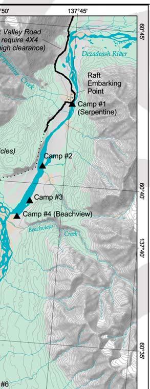
12 12 Alsek River Campsites between Serpentine put in to Camp 7


13 Alsek River Campsites between Camp 7 to Lowell Lake 13

.")


14 Feeding is a grizzly bear s primary activity from April through till October. Bears feed on plants at times of the year when the foliage is easier to digest and full of nutrients. Many leafy plants are eaten just as the leaves emerge. Roots are eaten in spring, late summer and fall (when most of the plant s nutrients are stored there). Grizzly bear habitat selection is strongly related to the seasonal availability of specifi c plants. As a result, disturbance or displacement from important feeding habitats have serious impacts on a bear s ability to acquire the necessary nutritional reserves for reproduction and survival through its 5-7 month winter denning period. 3. Grizzly Bear Habitats and Foods When selecting a campsite, it is important to learn which plants are eaten by bears and become familiar with habitats where these plants are found. All campsites are potential feeding areas for bears or have potential feeding areas close by. Camp in lower quality bear habitats that have a sparse abundance of bear foods! Remember to also select campsites that are open and sparsely vegetated to maximise the potential for you to detect bears and bears to detect you. 14 Photo : S. McDougall


15 a) Upstream of Lowell Lake Upstream of Lowell Lake bearroot, kinnikinnick, horsetail, fi eld locoweed and soapberry are the main plants eaten by grizzly bears during the rafting season. These plants are abundant along the river. Bearroot is common but found in localised areas and is particularly important to bears in years when the berry crops fail. Horsetail is common on wet slopes with a white spruce over story and less common on the river edge. Field locoweed is common and wide spread on open river fl ats that are likely to be chosen for campsites. Soapberry and kinnikinnick are common and widely distributed along river fl ats, edges of treed areas and in open stands of white spruce. Soapberry is frequently present in or on the edges of potential campsites. Wide open benches and gravel fans are common in the Special Preservation Area. These are also popular feeding areas for bears. Bears feeding in these areas may be particularly vulnerable to disturbance by people. The open areas offer no cover or security to which they can escape. In open habitats, bears have been observed running for cover, sometimes for extensive distances. Bears that are wary of humans, particularly females with young of the year, are likely to be displaced from these habitats if disturbed. Bearroot Hedysarum Photo : S. McDougall Locoweed Oxytropis Soapberry Sheperdia Horsetail Equisetum 15
 Horsetail (Equisetum spp.")
16 Table 2. Important plants eaten by grizzly bears upstream of Lowell Lake along the Alsek River, Kluane National Park, Yukon. 1 Month Plant Plant Part Eaten May Bearroot (Hedysarum alpinum) Horsetail (Equisetum spp.) Kinnikinnick (Arctostaphylos uva-ursi) roots leaves over-wintered berries June Horsetail Locoweed (Oxytropis spp.) (primarily Oxytropis campestris) leaves flowers July Soapberry (Shepherdia canadensis) Locoweed Horsetail berries flowers leaves August/ September Soapberry Kinnikinnick Bearroot (most important when berries are less abundant) berries berries roots 1 Less common food items include cow parsnip, grasses, sedges, willow catkins, rosehips, other berries, arctic ground squirrels, and ungulates such as moose. b) Downstream of Lowell lake As you travel downstream of Lowell Lake there is a marked transition from drier interior vegetation to wetter coastal vegetation. Habitats along the river below Lowell Lake are also important to bears. However, their food habits here may be different. Several food plants are known to be important to bears (Table 3). 16
17 Table 3. Plants likely to be eaten by grizzly bears in areas downstream of Lowell Lake on the Alsek River, Kluane National Park, Yukon. 1 Plant Bearroot (Hedysarum alpinum) Horsetail (Equisetum spp.) Locoweed (Oxytropis spp.) Kinnikinnick (Arctostaphylos uva-ursi) Red bearberry (Arctostaphylos rubra) Raspberry (Rubus spp.) Blueberry (Vaccinium spp.) Crowberry (Empetrum nigrum) Currant and Gooseberry (Ribes spp.) Highbush-cranberry (Viburnum edule) Soapberry (Shepherdia canadensis) Red-osier dogwood (Cornus sericea) Devils Club (Oplopanax horridus) Sweet-Cicely (Osmorhiza spp.) Angelica (Angelica spp.) Cowparsnip (Heracleum lanatum) Fireweed (Epilobium angustifolium) Plant Part Eaten roots leaves flowers berries (including over over-wintered berries of some species) early leaf shoots, berries roots leaves, stems leaves, stems early leaf shoots 1 Other food items may include arctic ground squirrels, moose, salmon, grasses, sedges, willow catkins, rosehips (Rosa spp.), twisted stalk (Streptopus spp.) and other berries. The vegetation is typically more dense downstream of Lowell Lake. While thick vegetation provides greater security for bears, these areas have an increased risk of surprise bear/human encounters. The terrain is also steeper in some areas leaving bears with fewer travel options along the river. 17


18 c) Lava North Portage UTM - 7V / (NAD 27) The Lava North Portage is a high-risk area for surprise encounters. Bear sign such as tracks, scats and diggings are common in this area. Be aware that visibility is poor, noise from the river can be loud and the wind is frequently blowing upstream. All of these factors greatly reduce a bear s ability to avoid you. When walking through this area, stay in as large a group as possible and make loud noises. Be aware that other high-risk areas are common along the river. Learn to recognize and avoid these areas. Photo : K. McLaughlin 18


19 4. Bear Safety In addition to the information provided here, be sure to read the You are in Bear Country brochure provided and other books on bear ecology and biology. You may want to check with your local university for the latest literature recommendations. 5. Reporting Bear Incidents and Observations All river users are required to report bear incidents to either Kluane National Park or Glacier Bay National Park. If you are involved in an incident or an encounter with a bear please record and report the information as soon as possible. OBSERVATIONS forms and contact information for Kluane National Park or Glacier Bay National Park are available at the Visitor Centres. Photo : D. Marois To report bear-human conflicts: Kluane National Park & Reserve call: am to 5pm, leave message. 24hrs Emergency: (toll free) Mail bear reports to: Kluane National Park, P.O. Box 5495 Haines Junction, Yukon, Y0B 1L0 Glacier Bay National Park & Tatshenshini-Alsek Park call: am to 9pm, leave message. 24hrs Emergency: Mail bear reports to: Attn: Tania Lewis P.O. Box 140, Gustavus, AK Photo : R. Edelman At the end of your trip please return your completed bear report forms to the Dry Bay Ranger, Glacier Bay National Park, or Kluane National Park This will enable Resource Conservations staff to track changes in bear behaviour and monitor bear use of designated campsites. The information is used to identify potential problems, which may then be investigated and appropriate management action taken. 19


20 Appendix Risk assessments of designated camping areas and campsites between Serpentine Creek and Lowell Lake Designated campsites have been assessed as having low, low to moderate or moderate potential for bear-human encounters and possible displacement of bears from their habitat. The location of designated campsites were chosen and assessed by considering several factors including: evidence of previous use by river travellers the abundance of bear food plants available; the amount of bear sign such as scats, mark trees, trails and beds; features that reduce the ability of bears and people to detect each other such as thick vegetation, prevailing winds, and noise from creeks; and geographic features that infl uence the likelihood of a bear travelling in an area, such as constrictions in terrain. Photo : S. McDougall 20


21 1. Serpentine Creek to the Dezadeash/Kaskawulsh Confluence From Serpentine Creek to Beachview Creek, camping is restricted to four designated campsites. Campsites 1 and 2 are recommended because they have the lowest potential for bear-human encounters and displacement of bears. a) Campsite 1 (River Right) Serpentine Creek UTM 8v / (NAD 27) This campsite is downstream of Serpentine Creek on the Northeast edge of a large patch of alders. A primitive road leads to this popular campsite and boat launch. There is a low abundance of bear foods at and immediately adjacent to this campsite. There has been no evidence that bears travel through this campsite regularly. The terrain at and adjacent to the campsite is fl at and travel is unrestricted. Bears are not funnelled through this campsite. Potential for Encounters Rated: Low Visibility is good in areas surrounding the campsite, however a stand of alders at the campsite makes visibility poor. This campsite is frequently used by day visitors, backpackers and river travellers so there may be higher potential for bears to obtain food or garbage at this site. Potential for Displacement Rated: Low This campsite has lower quality feeding habitat. Bears travelling along the river have alternate routes to avoid this campsite Photo : K. McLaughlin 21


22 b) Campsite 2 (River Left) Point of Peninsula UTM 8V / (NAD 27) This campsite is on river left at the southern tip of the large peninsula between Serpentine Creek and Beachview Creek. Relative to other areas, food abundance is relatively low. Bearroot and horsetail are sparse. Soapberry and locoweed are scattered along the edge and within the poplar/willow strip. The campsite is open and visibility is good towards the head of the peninsula. Visibility is obstructed along the outer edges of the peninsula, which is surrounded by water. Note: when water levels are low this campsite may be diffi cult to access. Photo : K. McLaughlin Potential for Encounters Rated: Low High quality bear habitat and a network of well used game trails are located at the north end of the peninsula and on the mainland river edge. Potential for Displacement Rated: Low Bears are likely to choose the higher quality habitats at the head of the lagoon and on the mainland edge of the river for feeding and travel. 22

23 c) Campsite 3 - (River Left) UTM 8v / (NAD 27) This campsite is approximately m upstream from the southern tip of a small peninsula. Visibility is relatively good. The main camping area is open and the terrain is fl at. Bearroot and locoweed are sparse. Soapberry is common in and along the edges of the open spruce and mixed spruce/ poplar forests to the south and southeast. Kinnikinnick and red bearberry are common with patchy distribution in the same habitats as soapberry. While bears are likely to use this campsite occasionally, they can easily avoid it. Photo : K. McLaughlin Potential for Encounters Rated: Low - Moderate Abundance of bear sign and high quality of habitat increases as you move away from the campsite, thus, the potential for encounters also increases. Camp in the open and as close to the river as possible. Hiking away from this campsite will greatly increase the potential for encounters and is not recommended. Potential for Displacement Rated: Low to Moderate Bears have alternatives to avoid the campsite if they detect people. 23


24 d) Campsite 4 (River Left) Beachview (north side of fan) UTM 8v / (NAD 27) This campsite is located on the upstream edge of the large alluvial fan located upstream of Beachview Creek. There is good visibility in all directions except a thick poplar/willow patch to the southeast. There is a low abundance of bear foods. Soapberry is abundant and kinnikinnick is common along the edge and behind the poplar/willow patch. A prominent and well-used game trail, with abundant bear sign, parallels the edge of the poplar/willow patch directly behind the campsite. Photo : S. McDougall Photo : K. McLaughlin Potential for Encounters Rated: Moderate Bears have frequently been observed near this campsite. Abundance of bear sign and high quality of habitat increases as you move away from the campsite, thus, the potential for interactions also increases. Hiking away from this campsite is not recommended. Camp in the open and as close to the river as possible. Do not camp near the game trail. Potential for Displacement Rated: Moderate The edges of this fan and the confl uence is a productive well-used feeding area with locoweed and soapberry. Bears have alternative travel routes around this campsite but may be displaced from what appears to be a major travel route along the river The Kaskawulsh/Dezadeash Confluence to 2.

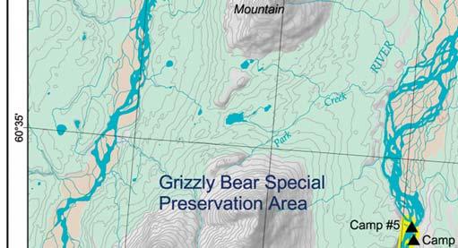
25 2.Campsite 9 above Lowell Lake Camping within this zone is restricted to one night. Two camping areas have been established on the river. The fi rst area is at Lava Creek, which offers a choice of three assessed campsites, and the second area is at Marble Creek with one assessed campsite. Camping at designated campsites within camping zones is recommended. a) Campsite 5 (River Right) - upper Lava 1 UTM / (NAD 27) Bear food and sign observed at this campsite were low. There was little evidence that bears use this area on more than an occasional basis. It is likely that most bears chose to travel on the other side of the river or possibly inland above the rock face. There are higher quality habitats for bears immediately upstream of this campsite. Photo : K. McLaughlin Potential for Encounters Rated: Low Rocky knolls restrict visibility. Stay alert for bears and make noise when walking around the lava rocks, particularly when walking to and from the lava pool to the west. Hiking away from this campsite is not recommended. Potential for Displacement Rated: Low There are better food sources upstream of the campsite. Bears likely chose alternative routes for travel around this campsite. 25

26 b) Campsite 6 (River Left) - upper Lava 2 UTM / (NAD 27) There is a low to moderate abundance of bear foods at this campsite. There are patches of bearroot, kinnikinnick and horsetail. Locoweed is scattered in the openings. Soapberry is sparse in the open fl ats around the campsite but more abundant along the edges of the trees. There was relatively little bear sign observed at this campsite. Visibility is poor at the base of the large rock outcrop in the small bay to the north. Visibility is good at the campsite downstream of the large rock outcrop. If bears detect people they have alternatives to avoid the campsite. Note: that when water levels are low this campsite may be diffi cult to access. Photo : K. McLaughlin Potential for Encounters Rated: Low - Moderate Camp in the large open area downstream of the large rock outcrop. Poor visibility at the upstream campsite in the small bay will make it more diffi cult to detect bears. The potential for surprise encounters increases with distance from the campsite because vegetation and rock reduce visibility. The safest route to the lava pools is to hike in the open where visibility is the best, downstream from the campsite and into the open fl ats before cutting upstream over to the rocks. Potential for Displacement Rated: Low - Moderate The surrounding area is open rock that offers alternative travel routes up slope. 26

27 c) Campsite 7 (River Right) Lava Creek UTM / (NAD 27) This campsite is beside the small creek just downstream of Lava Creek. Bearroot, kinnikinnick, horsetail and soapberry are less abundant at this campsite. Locoweed is common on the fl ats at the campsite. All major bear foods are abundant up slope and downstream of the campsite. Bear sign was low to moderate at the campsite but bears may use the trail that leads up slope from the campsite. Visibility is relatively good at the campsite but decreases in all directions with distance from the campsite. It is unlikely that many bears travel along the river upstream of Lava Creek because of impassable cliffs. Bears are most likely to travel on the East Side of the river or further inland. Because travel along the river to the north appears to be restricted, areas near this campsite may be used by bears for crossing the river. Bears may chose to travel down the trail from higher quality habitats to the west into the campsite. However, the campsite is in the open and bears are likely to detect people before they get into the campsite. Photo : K. McLaughlin Potential for Encounters Rated: Low - Moderate Camp below the rock bluffs on either side of the smaller creek downstream of Lava Creek rather than beside Lava Creek so bears can avoid the camp. Hiking from this campsite is not recommended. Potential for Displacement Rated: Low - Moderate This campsite may be located near a favoured river crossing area for bears. Therefore, movement patterns may be disrupted. However, with regular human use of this campsite bears will learn to expect people and cross the river further downstream. 27


28 d) Campsite 8 (River Right) Marble Creek UTM / (NAD 27) Campsite 8 is located on the downstream edge of Marble Creek. Soapberry is common and abundant in patches in and on the edges of the willow/poplar habitats around the campsite and the long poplar/willow/spruce/alder strips that parallel the river. Kinnikinnick was abundant in patches. All other bear food plants around this campsite are in relatively low abundance. There was a moderate amount of bear sign at this campsite. Visibility is relatively good at this campsite because it is relatively open on three sides. Visibility is poorest to the south because of willows. Bears are not funnelled through this campsite and have alternatives to avoid the campsite if they detect it. Photo : K. McLaughlin Potential for Encounters Rated: Low - Moderate Camp in the open flats away from the shrub edges to give bears the greatest opportunity to detect and avoid people. Hiking away from this campsite is not recommended because visibility is poor and the chances of surprising a feeding or travelling bear is high. Potential for Displacement Rated: Low Moderate Alternatives for bears to bypass this campsite are present. There are areas with abundant bear foods upstream of Marble Creek and on the opposite side of the river. 28
 for a view of the glacier. There is a good place to pull boats in.")
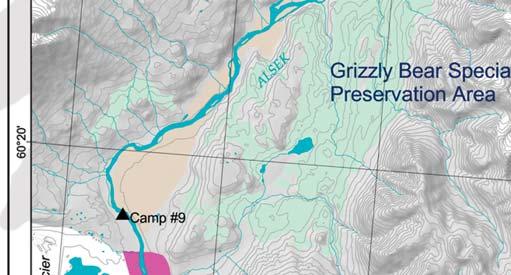
29 3. Campsite 9 (River Right) 2.5km Above Lowell Lake UTM 8V / (NAD 27) General Campsite Description This campsite is located on river right approximately 2.5 km above Lowell Lake. People camping at the site will likely hike to the moraine (>20 minutes) for a view of the glacier. There is a good place to pull boats in. Broad Habitat Description The campsite is in open Willow-Dryas shrub habitat. There is a small patch of alder in the middle of the campsite that could be used as a windbreak for a kitchen. Upstream there is balsam poplar with scattered spruce and thick shrubs including soapberry (Shepherdia canadensis) and willow (Salix spp.). Downstream there is a thick alder (Alnus crispa) and willow strip along the river. Inland there is a patch of less dense spruce (Picea glauca) with balsam poplar (Populus balsamifera) and soapberry. Behind this patch is Dryas spp. habitat. 29


30 Campsite 9 continued... Potential for Encounters Rated: Low Moderate Encounter Concern: Spring: L-M Summer: L-M Late Summer: L-M Visibility is restricted by vegetation the farther one moves form the site Visibility concerns are high in some places but moderate overall. Trails are broken. Terrain and vegetation do not funnel travel. However, travel concerns increase upstream of the campsite because the moraine is closer to the river edge. Potential for Displacement Rated: Moderate Displacement Concern: Spring: M Summer: M Late Summer: M Alternatives for bears to bypass this camp exist Recommendation Generally a lower risk campsite but risk increases upstream and downstream of the campsite. Hiking in this area will increase the risk for surprise encounters because there are areas with low visibility and habitat potential increases with distance from the campsite. People walking downstream will be walking into prevailing winds. This site should be considered as a temporary site when weather conditions prevent a safe advancement to the Lowell lake sites. 30


31 4. Lowell Lake Camping at the base of Goatherd Mountain is prohibited. Camping is permitted on the western outer edges of glacial till along the eastern shore of Lowell Lake. Camp as far away from the base of the mountain as possible, minimize the length of your stay and keep your activities at the base of the mountain to a minimum. a) Campsite 10 UTM 8V / (NAD 27) b) Campsite 11 UTM 8V / (NAD 27) 31
Kluane National Park and Reserve parkscanada.gc.ca. Bringing you Canada s natural and historic treasures. Photo : S. McDougall
 Kluane National Park and Reserve parkscanada.gc.ca Alsek River Camping & Travel Bringing you Canada s natural and historic treasures Photo : S. McDougall Table of Contents Introduction Background Campsite
Rafting the Alsek River in Kluane National Park & Reserve
 Photo: L. Gorecki Rafting the Alsek River in Kluane National Park & Reserve A Canadian Heritage River Fed by glacial meltwaters from the world s second highest coastal mountain range, the Alsek River offers
Recommendations related to mountain bike safety in bear habitat based on the fatality of Mr. Brad Treat on June 29, 2016.
 Board of Review Recommendations Recommendations related to mountain bike safety in bear habitat based on the fatality of Mr. Brad Treat on June 29, 2016. March 3, 2017 Board of Review Members 1 : Chris
Mountain Goats and Winter Recreation November 17, 2011
 Mountain Goats and Winter Recreation November 17, 2011 Summary Mountain goats need protection from disruption and displacement in their winter feeding areas by motorized and non-motorized recreationists
As outlined in the Tatshenshini-Alsek Park Management Agreement, park management will:
 Management Strategy General Strategy The priority management focus for the park is to ensure that its internationally significant natural, cultural heritage and recreational values are protected and that
APPENDIX A Data Sheets and Sample Site Photographs
 APPENDIX A Data Sheets and Sample Site Photographs Appendix C - Page 41 Seward Highway MP 99-105 Anchorage August 8, 2006 DOT&PF 1 RAC/EMC none none Southcentral Alaska N N N N N N Hydrology - the winter
Sawtooth National Forest Fairfield Ranger District
 United States Department of Agriculture Forest Service Sawtooth National Forest Fairfield Ranger District P.O. Box 189 Fairfield, ID. 83327 208-764-3202 Fax: 208-764-3211 File Code: 1950/7700 Date: December
Trail Phasing Plan. Note: Trails in the Clear Creek Canyon area (Segments will be finalized in the future to minimize wildlife impacts
 Note: Trails in the Clear Creek Canyon area (Segments 2 5 and a future JCOS connection) will be finalized in the future to minimize wildlife impacts Trail Phasing Plan P Parking 3 Easy Trail Intermediate
USING GRIZZLY BEAR HABITAT EVALUATIONS TO LOCATE TRAILS AND CAMPSITES IN KANANASKIS PROVINCIAL PARK
 USING GRIZZLY BEAR HABITAT EVALUATIONS TO LOCATE TRAILS AND CAMPSITES IN KANANASKIS PROVINCIAL PARK STEPHEN HERRERO, Faculty of Environmental Design and Department of Biology, University of Calgary, Calgary,
5.0 OUTDOOR RECREATION OPPORTUNITIES AND MANAGEMENT
 5.0 OUTDOOR RECREATION OPPORTUNITIES AND MANAGEMENT 5.1 Introduction This section describes the range of recreational activities that currently take place in Marble Range and Edge Hills Parks, as well
Appendix I Case-Studies in Wilderness Management
 Appendix I Case-Studies in Wilderness Management Management Issue Scenarios Note: These scenarios are meant to be used as guidelines for the program leader rather than to be read verbatim. Introduce a
ROBERTS CREEK PROVINCIAL PARK MASTER PLAN. November, 1981
 Ministry of Lands, Parks and Housing Parks and Outdoor Recreation Division Park Operations Branch North Vancouver, B. C. ROBERTS CREEK PROVINCIAL PARK MASTER PLAN November, 1981 Mr. G. Trachuk Director
PROUDLY BRINGING YOU CANADA AT ITS BEST. Management Planning Program NEWSLETTER #1 OCTOBER, 2000
 PROUDLY BRINGING YOU CANADA AT ITS BEST VUNTUT NATIONAL PARK Management Planning Program NEWSLETTER #1 OCTOBER, 2000 INTRODUCTION This newsletter launches the development of the first management plan for
Note: Coordinates are provided as Universal Transverse Mercator UTM Zone U21, North American Datum 1983 (NAD 83).
.") Northern Traverse Route Description The Northern Traverse (formerly the North Rim Traverse) is an unmarked and rugged backcountry hiking route. It is known be a demanding hike, because of its terrain and
Northern Traverse Route Description The Northern Traverse (formerly the North Rim Traverse) is an unmarked and rugged backcountry hiking route. It is known be a demanding hike, because of its terrain and
Each copy of any part of a JSTOR transmission must contain the same copyright notice that appears on the screen or printed page of such transmission.
 Black Bear Seasonal Food Habits and Disibution by Elevation in Banff National Park, Alberta Author(s): R. Michael Raine and John L. Kansas Source: Bears: Their Biology and Management, Vol. 8, A Selection
Little Grand Canyon near Pomona, Illinois
 Little Grand Canyon near Pomona, Illinois Below: View of the trail and the terrain created using the Map My Hike app Below: Summary of the hike created using the Map My Hike app Presented by: Jennifer
Appendix 1: Best Management Practices For Hang Gliding and Paragliding in Jasper National Parks
 Appendix 1: Best Management Practices For Hang Gliding and Paragliding in Jasper National Parks Name of Best Management Practice Best Management Practices for Hang Gliding and Paragliding in Jasper National
Appendix A BC Provincial Parks System Goals
 Appendix A BC Provincial Parks System Goals The British Columbia Provincial Parks System has two mandates: To conserve significant and representative natural and cultural resources To provide a wide variety
Theme: Predominately natural/natural appearing; rustic improvements to protect resources. Size*: 2,500 + acres Infrastructure**:
 Recreation Opportunity Spectrum (ROS) Classes The Recreation Opportunity Spectrum (ROS) provides a way to describe the variations in the degree of isolation from the sounds and influences of people, and
Rogue Gorge (Mt. Stella) Roadless Area-- T30S R3E (primarily in portions of Sections 23, 26, 33, 34 & 35)
 Roadless Area-- T30S R3E (primarily in portions of Sections 23, 26, 33, 34 & 35)") Rogue Gorge (Mt. Stella) Roadless Area-- T30S R3E (primarily in portions of Sections 23, 26, 33, 34 & 35) Rogue River-Siskiyou National Forest--High Cascades Ranger District Upper, higher elevation trail
Rogue Gorge (Mt. Stella) Roadless Area-- T30S R3E (primarily in portions of Sections 23, 26, 33, 34 & 35) Rogue River-Siskiyou National Forest--High Cascades Ranger District Upper, higher elevation trail
STONE MOUNTAIN PROVINCIAL PARK Purpose Statement and Zoning Plan
 1 STONE MOUNTAIN PROVINCIAL PARK Purpose Statement and Zoning Plan Stone Mountain Provincial Park is situated 140 km west of Fort Nelson at Kilometre 595 of the Alaska Highway. The 25 690 ha park is located
LESSON 5 Wilderness Management Case Studies
 LESSON 5 Wilderness Management Case Studies Objectives: Students will: review the key points of the Wilderness Act of 1964. brainstorm solutions for Wilderness management issues. Materials: Í Leave no
Dnigi Hut. Dnigi is Dnaina for Moose. Location:
 Dnigi Hut in places. Stay on the main thoroughfare. Continue along the ridge top, going east to a pass above Knob Creek. Just beyond here look for a left turn which descends north-northwest (61,45.578,-148,52.414,2081
Appendix A: San Francisco River Photos Gila National Forest
 Appendix A: San Francisco River Photos Gila National Forest These photos accompany our request for closure to demonstrate both the the outstanding ecological values associated with this area, as well as
A GIS Analysis of Probable High Recreation Use Areas in Three Sisters Wilderness Deschutes and Willamette National Forests
 Lindsey Kiesz Geo 565 Term Project 3/15/2010 A GIS Analysis of Probable High Recreation Use Areas in Three Sisters Wilderness Deschutes and Willamette National Forests Introduction The Three Sisters Wilderness
The following criteria were used to identify Benchmark Areas:
 7.0 BENCHMARK AREAS The Churn Creek Protected Area offers a significant opportunity to learn more about how grassland ecosystems function. One of the key tools that will be used to monitor larger grassland
Chapter The All-new, World-class Denver International Airport Identify Describe Know Describe Describe
 Chapter 10 The aerospace subject is very large and diverse. As seen in previous chapters, there are many subject areas. So far you have learned about history, weather, space and aerodynamics. Now you will
Hiking & Rafting the Alsek River. 16 Days
 Hiking & Rafting the Alsek River 16 Days Hiking & Rafting the Alsek River Ride 160 miles down the Alsek River with three extra days for hiking through the largest contiguous protected wilderness in the
Summary of prescribed fires in Prince Albert National Park 2015
 Summary of prescribed fires in Prince Albert National Park 2015 Prince Albert National Park conducted four controlled fires in spring 2015, plus an additional fire in October. Fuel Management for Hazard
Response to Public Comments
 Appendix D Response to Public Comments Comment Letter # Response 1, 2, 3, 4, 5, 7, 8, 9, 10, 11, 12, 13, 14, 15, 16, 17, 18, 19, 20, 22, 23, 24, 25, 26, 27, 29, 30, 31, 32, 33, 34, 35, 36, 37, 38, 39,
The Roots of Carrying Capacity
 1 Applying Carrying Capacity Concepts in Wilderness 1872 1964...shall be preserved for the use & enjoyment of the American people...in such manner as will leave them unimpaired for future generations...
ANAGEMENT. LAN November, 1996
 M ANAGEMENT P LAN November, 1996 for Paul Lake Provincial Park Ministry of Environment, Lands and Parks BC Parks Department Paul Lake Provincial Park M ANAGEMENT P LAN Prepared by BC Parks Kamloops Area
GOLDEN EARS PROVINCIAL PARK
 GOLDEN EARS PROVINCIAL PARK Trail Information as of October 10 th 2015 Do not underestimate the mountainous wilderness of Golden Ears Provincial Park. The combination of rugged terrain and rapidly changing
Sand Lakes Provincial Park. Draft Management Plan
 Sand Lakes Provincial Park Draft Management Plan 2 Sand Lakes Provincial Park Table of Contents 1. Introduction... 3 2. Background... 3 3. Park Purpose... 5 4. Park Management Guidelines... 6 Appendix...
MORGAN CREEK GREENWAY Final Report APPENDICES
 APPENDICES MORGAN CREEK GREENWAY Appendix A Photos of Existing Conditions in Trail Corridor Photos of existing conditions Main trail corridor - February 2009 Photos of existing conditions south bank Morgan
Marchand Provincial Park. Management Plan
 Marchand Provincial Park Management Plan 2 Marchand Provincial Park Table of Contents 1. Introduction... 3 2. Park History... 3 3. Park Attributes... 4 3.1 Natural... 4 3.2 Recreational... 4 3.3 Additional
Listing of Campsites on the Manigotagan River
 Listing of Campsites on the Manigotagan River This document lists and describes the campsites along the Manigotagan River between Highway #314 and the government dock in the community of Manigotagan. The
CRAZY HORSE TRAIL GUIDE
 CRAZY HORSE TRAIL GUIDE Abridged Version: July 2016 This is a short form of our interpretive trail guide for the Crazy Horse Trail. The full version of the guide has a more detailed description of the
Beaver Creek Provincial Park. Management Plan
 Beaver Creek Provincial Park Management Plan 2 Beaver Creek Provincial Park Table of Contents 1. Introduction... 3 2. Park History... 3 3. Park Attributes... 4 3.1 Natural... 4 3.2 Recreational... 4 4.
Yard Creek Provincial Park. Management Plan
 Yard Creek Provincial Park Management Plan Draft January 2010 Yard Creek Provincial Park Management Plan Approved by: telàlsemkin/siyam/chief Scott Benton Bill Williams Squamish Executive Director ation
Twin Lakes Avalanche Incident 1/31/2016
 Twin Lakes Avalanche Incident 1/31/2016 Location: Place State Published by: Dave Bingaman (PAC), George Halcom (PAC), and Kent May (PAC) Twin Lakes, Salmon River Mountains Idaho Date 01/31/2016 Time Summary
Mark West Creek Flow Study Report
 Mark West Creek Flow Study Report Biology and Geology of Mark West Creek The headwaters of Mark West Creek are located in the Mayacamas Mountain range, which border Napa and Sonoma County, where it then
Proposal to Redevelop Lower Kananaskis River-Barrier Lake. Bow Valley Provincial Park. Frequently Asked Questions
 Proposal to Redevelop Lower Kananaskis River-Barrier Lake Bow Valley Provincial Park Frequently Asked Questions What is being proposed? What are the details of the proposal? Where is the project area located?
welcome to the arctic
 Welcome to the Arctic welcome to the arctic Dear arctic guest. The Association of Arctic Expedition Cruise Operators (AECO) is an international organization for cruise operators. Our organization s main
BIG ANIMALS and SMALL PARKS: Implications of Wildlife Distribution and Movements for Expansion of Nahanni National Park Reserve. John L.
 BIG ANIMALS and SMALL PARKS: Implications of Wildlife Distribution and Movements for Expansion of Nahanni National Park Reserve John L. Weaver Conservation Report No.1 July 2006 4 SUMMARY The boundaries
General Rules for Use of Lands Managed by the. Middle Peninsula Chesapeake Bay Public Access Authority
 General Rules for Use of Lands Managed by the Middle Peninsula Chesapeake Bay Public Access Authority As a visitor to lands managed by the Middle Peninsula Chesapeake Bay Public Access Authority (PAA),
Applying Carrying Capacity Concepts in Wilderness
 Applying Carrying Capacity Concepts in Wilderness...shall be preserved for the use & enjoyment of the American people...in such manner as will leave them unimpaired for future generations... CSS 490 Professor
Eastern Lake Ontario Beach User Survey 2003/2004.
 Eastern Lake Ontario Beach User Survey 2003/2004. Introduction The eastern shore of Lake Ontario is a Biodiversity Investment Area that features a 17-mile long barrier beach of Great Lakes dunes and a
SeagrassNet Monitoring in Great Bay, New Hampshire, 2016
 University of New Hampshire University of New Hampshire Scholars' Repository PREP Reports & Publications Institute for the Study of Earth, Oceans, and Space (EOS) 9-28-2017 SeagrassNet Monitoring in Great
Final Recreation Report. Sunflower Allotment Grazing Analysis. July 2015
 Final Recreation Report Sunflower Allotment Grazing Analysis July 2015 Table of Contents Introduction... 3 Affected Environment... 3 Four Peaks Wilderness Area... 3 Dispersed Recreation... 3 Environmental
Wilderness Research. in Alaska s National Parks. Scientists: Heading to the Alaska Wilderness? Introduction
 Wilderness Research in Alaska s National Parks National Park Service U.S. Department of Interior Scientists: Heading to the Alaska Wilderness? Archeologist conducts fieldwork in Gates of the Arctic National
Emergency Preparedness for Farm Animals
 Emergency Preparedness for Farm Animals From barn fires to hazardous materials spills to natural disasters, emergency situations often call for special measures to shelter, care for or transport farm pets,
Pembina Valley Provincial Park. Draft Management Plan
 Pembina Valley Provincial Park Draft Management Plan 2 Pembina Valley Provincial Park Table of Contents 1. Introduction... 3 2. Park History... 3 3. Park Attributes... 3 3.1 Natural... 3 3.2 Recreational...
beach. Make the ford and follow the trail out to the junction with Red Creek Tr in an open grassy area.
 Description: This is a moderate to slightly strenuous 22.8 mile backpack (add 2.6 miles if you do the packless out and back to the Lion s Head) that will have you exploring nearly every thing that is The
ARCTIC PACIFIC LAKES PROVINCIAL PARK
 ARCTIC PACIFIC LAKES PROVINCIAL PARK PURPOSE STATEMENT AND ZONING PLAN March 2003 ARCTIC PACIFIC LAKES PROVINCIAL PARK Purpose Statement and Zoning Plan Located 90 km northeast of Prince George in the
Procedure for the Use of Power-Driven Mobility Devices on Mass Audubon Sanctuaries 1 September 17, 2012
 Procedure for the Use of Power-Driven Mobility Devices on Mass Audubon Sanctuaries 1 September 17, 2012 Background As part of Mass Audubon s mission to preserve the nature of Massachusetts for people and
Watchorn Provincial Park. Management Plan
 Watchorn Provincial Park Management Plan 2 Watchorn Provincial Park Table of Contents 1. Introduction... 3 2. Park History... 3 3. Park Attributes... 3 3.1 Natural... 4 3.2 Recreational... 4 3.3 Additional
MAIN LAKE PROVINCIAL PARK
 MAIN LAKE PROVINCIAL PARK PURPOSE STATEMENT AND ZONING PLAN March 2003 MAIN LAKE PROVINCIAL PARK Purpose Statement and Zoning Plan Primary Role The primary role of Main Lake Park is to protect a biologically
School Group Permits for Kananaskis Country Parks and Protected Areas-Memo
 Parks and Protected Areas School Group Permits for Parks and Protected Areas-Memo From: Date: January 4, 2005 Alberta Parks and Protected Areas Telephone: (403) 678-5508 To: All Alberta School Boards and
Questions and Answers related to Caribou and the Winter Road
 Updated December 18, 2009 Questions and Answers related to Caribou and the Winter Road Question: Does the operation of the winter road have an effect on the Bathurst Caribou Herd? Answer: Commercial use
INTERPRETING TOPOGRAPHIC MAPS (MODIFIED FOR ADEED)
") INTERPRETING TOPOGRAPHIC MAPS (MODIFIED FOR ADEED) Science Concept: Topographic maps give information about the forces that shape the features of Earth. Objectives: The student will: identify land features
INTERPRETING TOPOGRAPHIC MAPS (MODIFIED FOR ADEED) Science Concept: Topographic maps give information about the forces that shape the features of Earth. Objectives: The student will: identify land features
Sasagiu Rapids Provincial Park. Draft Management Plan
 Sasagiu Rapids Provincial Park Draft Management Plan 2 Sasagiu Rapids Provincial Park Table of Contents 1. Introduction... 3 2. Background and Park Attributes... 3 2.1 Park History.... 3 2.2 Natural Features...
A Publication of Friends of Sleeping Bear Dunes
 A Publication of Friends of Sleeping Bear Dunes 2014, Friends of Sleeping Bear Dunes, P.O. Box 545, Empire, MI 49630 www.friendsofsleepingbear.org info@friendsofsleepingbear.org Learn more about the Friends
NORTH CASCADE SLACIER CLIMATE PROJECT Director: Dr. Mauri S. Pelto Department of Environmental Science Nichols College, Dudley MA 01571
 NORTH CASCADE SLACIER CLIMATE PROJECT Director: Dr. Mauri S. Pelto Department of Environmental Science Nichols College, Dudley MA 01571 INTRODUCTION The North Cascade Glacier-Climate Project was founded
Washington Township MASTER PLAN. Addendum: Washington Township Master Plan
 Washington Township MASTER PLAN Addendum: Washington Township Master Plan CHAPTER XI RECREATION CORE DISTRICT Introduction The Recreation Core District generally encompasses the areas north of 30 Mile
THE ISLANDS PROVINCIAL PARK
 THE ISLANDS PROVINCIAL PARK Situated at the mouth of the Roseway River on Nova Scotia s scenic South Shore, The Islands is located across the harbour from the historic town of Shelburne. The park s picturesque
Proposal to Redevelop Lower Kananaskis Lake Campgrounds in Peter Lougheed Provincial Park. What We Heard
 Proposal to Redevelop Lower Kananaskis Lake Campgrounds in Peter Lougheed Provincial Park What We Heard In December 2016, Alberta Parks proposed to make several changes to campgrounds in the Lower Kananaskis
C E N T R A L C A T S K I L L S
 120 C E N T R A L C A T S K I L L S Central Catskills Once out of the southern parts of the Catskills, the Long Path enters the more well traveled and civilized regions. The trail joins the Devil s Path,
Finn Creek Park. Management Direction Statement Amendment
 Finn Creek Park Management Direction Statement Amendment November 2013 Management Direction Statement Amendment Approved by: Jeff Leahy Regional Director, Thompson Cariboo BC Parks November 12, 2013 Date
Submission on the Tukituki Catchment Proposal: EPA reference numbers; NSP 13/ , NSP 13/ , NSP 13/ , NSP 13/02.
 Hutt Valley Tramping Club PO Box 30 883 LOWER HUTT 5045 Tukituki Catchment Proposal Environmental Protection Agency Private Bag 63 002 WELLINGTON 6140 29 July 2013 Submission on the Tukituki Catchment
ANAGEMENT P LAN. February, for Elk Lakes and Height of the Rockies Provincial Parks. Ministry of Environment, Lands and Parks BC Parks Division
 M ANAGEMENT P LAN February, 1999 for Elk Lakes and Height of the Rockies Provincial Parks Ministry of Environment, Lands and Parks BC Parks Division Elk Lakes & Height of the Rockies Provincial Parks M
South Colony Basin Recreation Fee Proposal
 South Colony Basin Recreation Fee Proposal Purpose and Need for Collecting Fees in South Colony Basin: Forest Service appropriated funds have not been sufficient to maintain current recreational services
Koroc River Palmer River Loop
 parkscanada.gc.ca Multi-Day Hiking Route Koroc River Palmer River Loop Torngat Mountains National Park T. Knight, Parks Canada 425000m.E. 64 15'0"W 30 64 10'0"W 35 64 5'0"W 40 64 0'0"W 45 63 55'0"W 50
Marvine Creek Trail BCM Course Area Guide Backcountry. Trip Code Team Leader
 Marvine Creek Trail BCM Course Area Guide Backcountry Trip Code Team Leader Table of Contents Trail Summary... 3 Trail Information... 3 Trail Description... 4 Route Description... 5 Trail Distances...
CHAPTER III: TRAIL DESIGN STANDARDS, SPECIFICATIONS & PERMITS
 CHAPTER III Trail Design Standards, Specifications & Permits This chapter discusses trail standards, preferred surface types for different activities, permits, and other requirements one must consider
Other Agencies and Organizations
 Daniel Boone National Forest 1700 Bypass Road WInchester, KY 40391 859-745-3100 Location Northern terminus is near Morehead, Kentucky. Southern terminus is located in the Big South Fork NRRA in Tennessee.
Proposal to Redevelop Lower Kananaskis River-Barrier Lake. Bow Valley Provincial Park
 Frequently Asked Questions Proposal to Redevelop Lower Kananaskis River-Barrier Lake Bow Valley Provincial Park Frequently Asked Questions What has been decided? What are the details of the plan? What
Non-motorized Trail Plan & Proposal. August 8, 2014
 Town of Star Valley Ranch, Wyoming and the Star Valley Ranch Association in partnership with the USDA Forest Service, Bridger-Teton National Forest, Greys River Ranger District Non-motorized Trail Plan
Map 1.1 Wenatchee Watershed Land Ownership
 Map 1.1 Wenatchee Watershed Land Ownership Map 1.1 Wenatchee Watershed Land Ownership The Wenatchee watershed lies in the heart of Washington state in Chelan County. Just larger than the state of Rhode
KANANASKIS COUNTRY PROVINCIAL RECREATION AREAS MANAGEMENT PLAN DRAFT TERMS OF REFERENCE - November 20, 2007
 KANANASKIS COUNTRY PROVINCIAL RECREATION AREAS MANAGEMENT PLAN DRAFT TERMS OF REFERENCE - November 20, 2007 BACKGROUND There are 42 Provincial Recreation Areas (PRAs) within Kananaskis Country located
STREAMWALKS REVISITED
 STREAMWALKS REVISITED Maggie A. Kendrick, Department of Earth Sciences, University of South Alabama, Mobile, AL, 36688. Email: mak0209@aol.com. The goal of my research is to have a system of streamwalks
What are you getting into?
 Overnight Camping What are you getting into? You will be hiking with your gear to a campground about ½ mile away and spending 1 night camping You will help to prepare a meal over an open flame You will
Typical avalanche problems
 Typical avalanche problems The European Avalanche Warning Services (EAWS) describes five typical avalanche problems or situations as they occur in avalanche terrain. The Utah Avalanche Center (UAC) has
Part 1: Introduction to Decision Making
 Part 1: Introduction to Decision Making 1.1 - Anatomy of a Decision ABOUT AIARE Learning Outcomes Identify that backcountry decision making involves five key components: Plan, Observe, Teamwork, Choose
DIXIE HIGHWAY Region of Peel NAI Area # 1304, 1320, 2449, 2625, 3961
 DIXIE HIGHWAY 407 1 Region of Peel NAI Area # 1304, 1320, 2449, 2625, 3961 Toronto and Region Conservation Authority City of Brampton Size: 36 hectares Watershed: Etobicoke Creek Con 4 E, Lots 13, 14 Ownership:
Guthega to Mt Twynam. 2183m. 1583m. 6 hrs 45 mins 14.8 km Return. Experienced only. 913m
 Guthega to Mt Twynam 6 hrs 45 mins 14.8 km Return Experienced only 5 913m This walk starts from Guthega and makes its way along the Snowy River to the Illawong Lodge, via the Blue Cow Creek flying fox.
Connie Rudd Superintendent, Black Canyon of the Gunnison National Park
 National Park Service U.S. Department of the Interior Black Canyon of the Gunnison National Park and Curecanti National Recreation Area Information Brochure #1 Wilderness and Backcountry Management Plan
Whitemouth Falls Provincial Park. Draft Management Plan
 Whitemouth Falls Provincial Park Draft Management Plan Whitemouth Falls Provincial Park Draft Management Plan Table of Contents 1. Introduction... 3 2. Park History... 3 3. Park Attributes... 4 3.1 Natural...
Whitehorse Bear Hazard Assessment
 Whitehorse Bear Hazard Assessment Whitehorse, Yukon Territory Prepared by Wind River Bear Institute Canada Lori Homstol and Claire Edwards With GIS support from Sandra MacDougall and Andrew Smith Sponsored
Kitimat. Pacific Inland Coast. Hiking Guide Kitimat, British Columbia, Canada
 Kitimat Pacific Inland Coast Hiking Guide Kitimat, British Columbia, Canada 2010-2011 Sites and Trails Emergency Call 911 Police - Fire - Medical 2 Welcome to Kitimat This information was produced to assist
Chitina-Kennecott Area Additions
 Chitina-Kennecott Area Additions This scenery packages is designed to give the user many add on locations to fly to and explore in the Chitina-Kennecot Glacier areas near McCarthy (15Z). You should add
Pinawa Provincial Park. Draft Management Plan
 Pinawa Provincial Park Draft Management Plan Pinawa Provincial Park Draft Management Plan Table of Contents 1. Introduction... 3 2. Park History... 3 3. Park Attributes... 4 3.1 Natural... 4 3.2 Recreational...
Existing Resource Information
 Botanical and Wildlife Vegetation alliances/wildlife habitats Grasslands annual/perennial Chaparral mixed/montane/chamise-redshank Riparian montane/valley foothill riparian Sierran mixed conifer Montane
BRACEVILLE NATURE PRESERVE Introductions History Present Conditions Future Development Plans Implementation Strategies Statistics
 BRACEVILLE NATURE PRESERVE Introductions History Present Conditions Future Development Plans Implementation Strategies Statistics Introduction Braceville Nature Preserve is one of MetroParks largest preserves.
Summer 2013 Dalton Highway Recreation Study
 Summer 2013 Dalton Highway Recreation Study Implications for Recreation and Visitor Services Planning Peter J Fix School of Natural Resources and Extension University of Alaska Fairbanks OLLI Session 2
CHESTER-SAWMILL WINTER TRAIL ENHANCEMENT PLAN KANANASKIS COUNTRY. Draft May 9, 2016
 CHESTER-SAWMILL WINTER TRAIL ENHANCEMENT PLAN KANANASKIS COUNTRY Draft May 9, 2016 TABLE OF CONTENTS 1 INTRODUCTION... 1 2 PLAN AREA... 4 2.1 Biophysical... 4 2.2 Park Management Zoning... 6 2.3 Existing
Field Trips General Information
 Field Trips General Information Individuals planning to participate in a field trip are encouraged to contact the trip leader in advance so the leader knows who is planning to come. Please do not call
Erskine Creek via Pisgah Rock and Jack Evans
 Erskine Creek via Pisgah Rock and Jack Evans 4 hrs 30 mins 7.1 km Circuit Very experienced only 6 421m This walk visits some great lookouts and explores the lower section of Erskine Creek. Most of the
Comparison Pictures of Receding Glaciers
 Comparison Pictures of Receding Glaciers In the photo above, the west shoreline of Muir Inlet in Alaska's Glacier Bay National Park & Preserve is shown as it appeared in 1895. Notice the lack of vegetation
Draft Concept Plan. for the. Proposed Saskatoon Mountain Provincial Recreation Area
 Draft Concept Plan for the Proposed Saskatoon Mountain Provincial Recreation Area April 2014 Table of Contents INTRODUCTION... PROPOSAL SUMMARY... 1.0 DESCRIPTION OF THE PROPOSED SASKATOON MOUNTAIN PROVINCIAL