Manitou Islands Provincial Nature Reserve Management Plan
|
|
|
- Philip Long
- 5 years ago
- Views:
Transcription
1
2 Manitou Islands Provincial Nature Reserve Management Plan Ministry of Natural Resources Ontario
3 1990 Queen s Printer for Ontario Printed in Ontario, Canada Single copies of this publication can be obtained from Ontario Ministry of Natural Resources, North Bay District Office, P.O. Box 3070, Hwy. 63, North Bay, Ontario, P1 B 8K7, telephone (705) PRICE: $2.00 (Tax Included) ISBN
4 Approval Statement We are pleased to release this management plan for the Manitou Islands Provincial Nature Reserve. The designation of these four islands for protection under the Provincial Parks Act and implementation of the policies herein will ensure their ecological integrity for future generations. The Manitou Islands are representative of island ecology in Lake Nipissing. They are home to a variety of plant communities, outstanding colonial nesting habitat for Great Blue Heron and Osprey, and an intriguing geological history. They offer a high quality recreational setting 10 kilometres from North Bay for day use, water-based recreation. This nature reserve and the longterm protection of its provincially significant resources will be sustained through the cooperative efforts of the Ontario Ministry of Natural Resources, the Ontario Heritage Foundation, Nature Conservancy of Canada, and local naturalist clubs. M.A Klugman Regional Director Northeastern Region Norm R. Richards Director Parks and Recreational Areas Branch
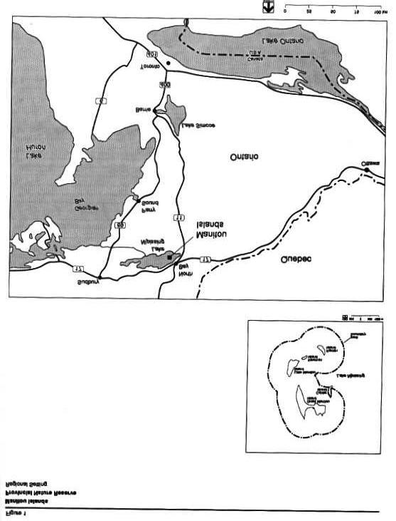
5 Table of Contents 1.0 Introduction Resource Characteristics Classification Park Goal Objectives Protection Heritage Appreciation Boundary Park Zoning Access Zones Nature Reserve Zones Historical Zone Resource Management Landforms Vegetation Wildlife Fisheries Cultural Features Land Management Patent Properties Operations Policies Visitor Services Research Recreation Management Development Sign System Operation Base Great Manitou Beach Highway 17 Lookout Newman Island Implementation Short-Term Work Program Planning and Park Operations Long-Term Special Funding Initiative Plan Review Public Consultation Select References 11 List of Figures 1. Regional Setting vi 2. Significant Areas 3 3. Development and Zoning 5 v
6 vi
7 1.0 Introduction Four islands in Lake Nipissing, 10 kilometres southwest of North Bay, make up the Manitou Islands Provincial Nature Reserve (Figure 1). The Manitou Islands joined other provincial nature reserves in the Ontario Provincial Park system in 1989, representing distinctive wildlife, natural habitats, bedrock, and landforms of this area of the province. The Ontario Ministry of Natural Resources will manage the Manitou Islands in cooperation with the Ontario Heritage Foundation (OHF), an agency of the Ontario Ministry of Citizenship and Culture. Their mandate is to preserve and promote Ontario s natural, historical, archaeological, and architectural heritage. As an agent of the Crown, the OHF accepted a gift of the majority of land on Great Manitou Island in 1982 from a private donation through the encouragement of the Nature Conservancy of Canada to protect habitats associated with a large Great Blue Heron colony. To evaluate the ways of protecting the needs of the heronry, the OHF commissioned a study of other resources in the immediate area in On the basis of this work, it was determined that there were a variety of resources and potential uses and recommended that a management strategy be prepared for the four islands as a provincial nature reserve. Policies for resource protection and use of the Manitou Islands were proposed by the Ontario Ministry of Natural Resources in a preliminary management plan. This was reviewed with the public in Resource Characteristics This nature reserve is representative of island ecology in Lake Nipissing. The islands are underlain by glacial till and lacustrine deposits associated with small, weekly, broken bedrock occurrences. The environmental conditions on a site control vegetation development (i.e. soil moisture regime, rooting medium or substrate, and microclimate). A life science survey of the Manitous (Noble 1984) determined that conditions here range from dry rock to wet sandy sites. Microclimate is normal to warmer than normal for this site district (5E5). The major plant communities are forests treed with Basswood, three species of Ash, Silver Maple, White Birch, White Cedar, Burr Oak, and Sugar Maple. A mosaic of thickets with Striped Maple, Chokecherry, Canada Yew, Poison Ivy, and Ground Hemlock are common. The Great Blue Heron colony, Osprey nesting sites, and some 50 other species of breeding birds are very important elements of the ecology of these islands in the Lake Nipissing basin. The Manitou Islands have an intriguing geological history. The majority of the bedrock underlying Lake Nipissing is metamorphic rook some 2.5 billion years old (Late Precambrian Period). The island bedrocks are actually much younger, with an age of 565 million years (Middle Cambrian Period). The core of each island is the remnant of a rock that crystallized after welling up from the depths of the earth during an unsettled geological environment. This occurred during a rift or separation and cave-in of the crust of the earth, which extended from the western end of Lake Nipissing to the St. Lawrence valley. The opening brought molten rock from great depths below the crust, which bubbled up to solidify as a cone-like structure within the older rocks of the crust. If you look at the Manitou Islands from the air, they appear as a broken ring - the outline of one of these intrusive cones. A geological survey of the islands identified this feature as the Manitou Islands Complex. Erosion has broken down the complex overtime. One major erosional event was succeeded by the deposition of limestone rock on the islands. Some 450 million years ago (Ordovician Period), a shallow ocean environment was present engulfing an area including the Great Lakes to James Bay. Organisms living in that environment were deposited and their fossils are now seen within horizontal sedimentary layers of buff coloured lime-stones in limited outcrops along the island shorelines. Glaciation was active in this area between 45,000 and 9,000 years ago, scouring and reshaping the surface. This left a veneer of soils over much of the Canadian Shield. The sandy tills on the islands and the south shore beach of Great Manitou Island have their origin from their soils. The islands have been used for seasonal human habitation for at least the last 2,000 years. Archaeological investigations have uncovered artifacts associated with Woodland Indian cultural technologies. A purported historical fur trade post and stopover use of the islands have yet to be documented. Recent man-made developments occurred on Little Manitou and Newman Islands. These locally significant mineral exploration activities resulted in subsurface and surface disturbance of both islands. There is a small lime kiln structure on Little Manitou Island. It is all that remains from the use of limestone during the construction of the North Bay portion of the Canadian Pacific Railway. A headframe and some 135m of vertical shaft were active on Newman Island between 1953 and Uranium deposits were explored in that area. The ~ was never brought to production. 1
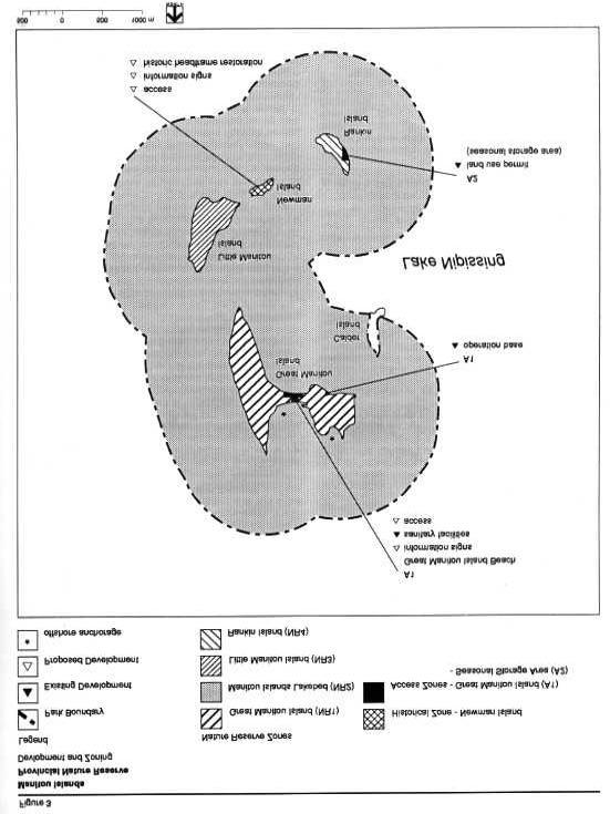
8 2.0 Classification The Manitou Islands are classified as a provincial nature reserve. This will enable the Ontario Ministry of Natural Resources to protect the landform associated with the Manitou Islands Complex, island and lakebed limestone bedrocks, habitat and seasonal nesting use by Great Blue Heron and Osprey, and archaeological and historical sites. Public awareness of these features will be enhanced by the provincial nature reserve designation. 3.0 Park Goal The following goal and objectives have been derived from the Ontario Provincial Parks Planning and Management Policies (OMNR 1978). They will guide zoning, resource management, client services, and development of this provincial nature reserve. Manitou Islands Provincial Nature Reserve will represent distinctive natural habitats and landforms of the province to be protected for educational purposes and as gene pools for research to benefit present and future generations. Management will protect and perpetuate the islands natural and cultural features. Existing day use recreation will be permitted to continue. 4.0 Objectives Provincial objectives for protection and heritage appreciation will guide the management and use of the provincial nature reserve. 4.1 Protection The protection objective is: Manitou Islands Provincial Nature Reserve will protect provincially significant, special, and representative features of Lake Nipissing's natural history. The islands contain significant natural and cultural features (Figure 2). Great Blue Heron and Osprey nesting sites will be the central resources to protect. The provincial nature reserve, geology, and landforms represent different geological times. The oldest bedrocks are Late Precambrian age metamorphics and middle Cambrian age igneous intrusives. Ordovician age limestones as well as Quarternary glacial deposits are also present. Island landforms are not being modified in any significant way by erosional processes of Lake Nipissing. The Manitou Islands Provincial Nature Reserve will protect plant and animal communities that are representative of the present day ecology of islands in Lake Nipissing. Cultural features related to Middle Woodland archaeological sites and recent mineral exploration works will be protected. Manitou Islands Provincial Nature Reserve includes four islands. One of these, Great Manitou, is managed through a custodial agreement with the Ontario Heritage Foundation. The purpose of the agreement is to ensure that the natural and cultural features of the Island are protected. 4.2 Heritage Appreciation The heritage appreciation objective is: Manitou Islands Provincial Nature Reserve will provide opportunities for unstructured, individual exploration and appreciation of the natural environment. Use and development of the Manitou Islands will not disturb the heron and Osprey nesting areas. Development, which is proposed for Great Manitou Island, will not encourage access to their critical nesting habitats. These biological resources and those concerned with geological and archaeological features will be interpreted to t he public through means that are compatible with the protection objective. Recreation use and park operation services will be accommodated on small areas of Great Manitou and Rankin Islands. An historical zone on Newman Island will provide interpretation of all themes related to this provincial nature reserve through viewing facilities and outdoor displays. 5.0 Boundary The boundary for the nature reserve was identified on the basis of protecting related natural and cultural features. Most of the property in the island group is Crown land. Patent lots that remain on Great Manitou Island will be acquired as they become available and as funds permit. One land use permit, the only alienated land on Rankin Island, will continue. Calder Island and other private properties are not affected by this plan. The Manitou Islands are located in an unorganized part of the District of Nipissing with no zoning orders or official plans in effect as of publication of this document. Prior to February 9, 1981, Great Manitou Island was privately owned. The easterly part of that island had been subdivided in 1920, and 29 lots were sold over the 2
9 3
10 years. The unsold lots were owned by Michael J. Brophy, In Trust, K.Y.B. Northern Limited, and Great Manitou Park Company Incorporated. The mining rights were leased to Nova Beaucage Mines Limited for a period of 99 years beginning April 7, That lease was forfeited in Principle owners of the Great Manitou Island property sold their holdings to a private individual who, in turn, donated it, through the efforts of the Nature Conservancy of Canada and the Ontario Heritage Foundation, to the Crown in Several other individual lots have since been purchased by the Crown. Negotiations to purchase the remaining lots are continuing. The Ontario Ministry of Natural Resources holds an agreement with the OHF to manage Great Manitou as part of the provincial nature reserve. 6.0 Park Zoning Lands and waters within the Manitou Islands Provincial Nature Reserve are zoned to their most appropriate use to satisfy the park goal and objectives. The zones are Access, Nature Reserve, and Historical (Figure 3). Management measures to protect nature reserve resources are discussed in the Resource Management section. 6.1 Access Zones The islands are quite visible from points in North Bay and Highway 17 west. From certain vantage points, they can be viewed as part of the overall landscape of Lake Nipissing. People travel to the islands by boat from North Bay and other centres for day use, water based recreation. Yachts sometimes moor offshore. The islands also serve as a refuge to storm-bound boaters. The Ontario Northland ferry service, Chief Commanda II, passes through the islands on its North Bay - French River cruise. Two access zones will act as staging areas where a minimum of facilities are required for day use recreation and park operations. Camping will not be permitted on any of the islands. Great Manitou Island Beach and Operations Base A1 (2 ha) Access Zone The south facing beach of Great Manitou Island will be signed as a day use area to accommodate existing boating and swimming. Sanitary facilities will be maintained. No docking structure will be provided at the public beach. Visitors will be made aware of the need to limit their use to the cleared area of backshore to avoid disturbance of habitat and seasonal use of the Great Blue Heron and Osprey nesting on the island. A plaque acknowledging the work of the Ontario Heritage Foundation, the Nature Conservancy of Canada, and their donor for land purchases will be placed on site. In the future, some self-use interpretive displays may be installed here. The existing frame building, about one kilometre east of the beach, will be maintained as a base of operations for the nature reserve. Uses of the building will be determined in the operating plan (see section 10.2). Seasonal Storage A2 (1 ha) Access Zone Winter ice fishing huts have been traditionally stored on the east shore of Rankin Island in a location held as a land use permit for that purpose. The site is convenient to the winter operational needs of the Lake Nipissing ice fishing businesses. The low relief of the island makes it easy to get the ice huts on Lake Nipissing for the winter and then acts as a storage area with the arrival of spring. This site is adjacent to the best representative Basswood forest stand on the Manitou Islands. An ecological evaluation to provide a more detailed description of the use of the area and the condition of the Basswood stand is needed to determine whether there are any impacts on the Basswood stand as a result of the present pattern of use. It is determined that this use causes impact to the Basswood stand, then a suitable alternate ice hut storage site will be designated off the islands. 6.2 Nature Reserve Zones Four nature reserve zones will protect the significant geological, biological, and cultural elements of the Manitou Islands. Park development will not occur in these zones. Great Manitou Island NR1 (80 ha) Nature Reserve Zone The following features will be protected: the Great Blue Heron colony - one of the largest known colonies in interior Canada; the Osprey nesting sites - significant given that there are four active nests (1984) on one island; representative communities of Black Ash, Silver Maple, Basswood, White Birch, Burr Oak, and 4
11 5
12 White Cedar forests with Ground Hemlock, Chokecherry, and Poison Ivy thickets; the Manitou Islands Complex s geological history as recorded in the outcrops of the island landform; Middle Ordovician limestone outcrops on the island shoreline; the glacial landform (Quarternary Period) as recorded in surficial material; and, Woodland archaeological sites, which are significant in piecing together the native habitation and travel patterns in the area. Manitou Islands Lakebed NR2 (200 ha) Nature Reserve Zone This zone includes submarine landforms associated with the four islands that occur in the provincial nature reserve. The submarine landforms are the roots of bedrock types that outcrop on the four islands and, as such, will be protected to keep the Manitou Islands Complex s geological feature and limestone pavements intact. The Calder Island area will not be represented. These submarine features will not be modified through park development. Little Manitou Island NR3 (30 ha) Nature Reserve Zone This island has the most extensive bedrock outcrops of all the islands in the group. Although there is no nesting presence of Osprey or Great Blue Heron here, these birds feed along the shoreline. The best representative communities of White Birch, White Cedar, and Chokecherry thickets found on the islands grow here. Rankin Island NR4 (10 ha) Nature Reserve Zone All bedrock types in the area occur on this island. Although there are no nesting Great Blue Heron or Osprey on Rankin lsland, there are feeding sites here. The upland thickets and an almost pure stand of Basswood are better represented here than on any other island in the Manitou Islands group. 6.3 Historical Zone One historical zone covering Newman Island will represent historic mineral exploration of the Manitou Island Complex. It will be managed to give recognition to the broader objective of heritage appreciation of all themes occurring in the nature reserve. Newman Island H1 (4 ha) Historical Zone The headframe will be retained as a landmark representative of mineral exploration and the Manitou Islands Complex. The mine shaft was sealed in The actual workings (1953 to 1960) developed a vertical shaft of 135 metres with 762 metres of drifts and crosscuts to examine uranium mineralization before the site was abandoned. Although a pilot treatment plant to process the ore was constructed on the north shore of Lake Nipissing, the island mine never came to production, and the site was abandoned in Collapsed buildings on the island will be cleaned up. The feasibility of restoring the headframe and maintaining a day use interpretive facility here will be evaluated: outdoor displays, a two kilometre t rail, and lookouts. 7.0 Resource Management Management and planning policies (1978) for provincial nature reserves and the North Bay District Land Use Guidelines (1983) provide the broad context for resource management. This section adds detail to those policies with guidelines that are specific to the Manitou Islands. Resource planning will follow the overall principle that significant, special, and representative resources are important to the integrity of the nature reserve. Interference with the natural geomorphological and ecological processes will be minimized. There have been no active resource management programs to enhance the natural heritage of the islands in the past. Measures to sustain the resources that are significant, special, and representative are described as follows for landforms, vegetation, wildlife, fisheries, and cultural features. These measures will be written into a park operations plan. 7.1 Landforms Submarine and surface expressions of the landforms associated with the Manitou Islands Complex, the Ordovician limestones, and island shorelines will not be altered through extraction or in filling. Minor alterations may be considered to upgrade docking facilities in two locations. A boat dock for operation needs of the nature reserve will be maintained within Zone Al as part of the operations base. Should there ever be a need to accommodate small craft or a tour boat stop at the Manitou Islands, there is a disturbed area where a large dock once served Newman Island for mineral exploration purposes. The plan will have to be reviewed to determine the extent of docking needs, should this be proposed in the future. 6
13 7.2 Vegetation Vegetation management planning will recognize the dynamic succession of forests, thickets, open areas, and shoreline wetlands. All plants including Poison Ivy, Stinging Nettle, and Canada Yew are integral to the representative communities on the islands. Suitable nesting habitat for Great Blue Heron and Osprey will be encouraged. The existing nesting areas of heron and Osprey will receive adequate vegetation buffering to prevent disturbance by recreational uses of the access zone on Great Manitou Island. The Rankin Island Basswood stand will be monitored to determine if there is any encroachment by uses associated with the adjoining land use permit. If the permitted use is found to affect the Basswood stand, then a location for ice hut storage will be developed elsewhere and the Rankin Island site would be allowed to recover through natural succession. Non-native plant species will not be deliberately introduced to the nature reserve. Where it is determined that such disturbance has occurred on the Manitou Islands in the past or should it unintentionally happen in the future, a management program will be developed to restore natural vegetation to the disturbed site(s). There appears to have been a low incidence of natural fires on the Manitou Islands. In as much as fire may be a natural occurrence, the forest makeup suggests that it is not an integral process in vegetation succession on the islands. Given the small area on each island and the potential hazards to the Great Blue Heron and Osprey nesting sites and park visitors, fires will be suppressed in accordance with the approved park plan and fire operations plan for the Northeastern Region to ensure that park objectives are met. Commercial logging is not permitted. 7.3 Wildlife The management of wildlife will recognize the special characteristics of species diversity and the natural ecology of island communities in Lake Nipissing. Islands, generally speaking, have fewer total numbers of species and lack many predator species found in similar mainland habitats. Some large populations of certain species often develop in response to the lack of predators, available food supplies, and suitable breeding habitats. This seems to have been the case for Great Blue Heron and Osprey on Great Manitou Island. Protection of heron and Osprey populations is central to the ecology of the Manitou Islands. These wildlife resources will be monitored. In this way, optimum nesting ecology and population dynamics will be determined. As a result, vegetation management may be required as described in the management guidelines for heronries (1984) and Osprey (1983). Sport hunting and trapping are not permitted. 7.4 Fisheries Sportfishing will be permitted within the Manitou Islands Provincial Nature Reserve. Commercial fishing, including commercial bait fishing, will not be permitted. 7.5 Cultural Features Two Woodland Indian archaeological sites and a recent history of mineral exploration contain significant and representative cultural features that will be protected. The Woodland sites and other sites on Lake Nipissing contain artifacts that are being used to interpret these ancient cultures resource utilization and travel patterns in the region. Further archaeological work will be conducted to understand the significance of the Manitou Islands as a resource area to these early peoples. A complete archaeological salvage will be undertaken on sites that are vulnerable to disturbances. The historical zone on Newman Island contains what remains of the mineral exploration infrastructure from the 1950 s. The headframe will be evaluated to determine the feasibility of retaining it as a landmark and an interesting feature to relate cultural and natural heritage to park visitors (see Visitor Services section). 8.0 Land Management The management of the Manitou Islands Provincial Nature Reserve will be guided by the principle of having a natural landscape free from the modified impacts of man. The Provincial Park Planning and Management Policies (OMNR 1978) for provincial nature reserves will be adhered to. The following are specific policies for patent properties. 8.1 Patent Properties The patent properties on Great Manitou Island are being 7
14 acquired on the open market as lots are put up for sale and as funds and priorities permit. The one land use permit on Rankin Island will be allowed to continue if it is found that it does not negatively impact on the adjacent stand of Basswood. Additional areas will not be available in any form of tenure. Calder Island will remain outside Manitou Islands Provincial Nature Reserve. 9.0 Operations Policies Operations will be managed in accordance with the general planning and management policies for provincial nature reserves (1978). Specific direction, where required to meet the particular needs of the Manitou Islands, will be provided through visitor services planning and park operations planning (see Development section). Minimum operating standards for day use areas in provincial parks will apply. 9.1 Visitor Services A visitor services plan will be developed. This will involve area parks and other agencies as appropriate to relate the following themes: dynamic earth history associated with the Manitou Islands Complex s geological processes and limestone bedrock environments; Manitou Islands ecology relative to the plant and animal communities on Lake Nipissing; the ecology of Great Blue Heron and Osprey: their breeding habitat needs, feeding range patterns, and population; and, the archaeology and history of human habitation and resource use of the Manitou Islands from native peoples to fur trade to mineral exploration and finally to recreation and conservation activities. Self use information about all the themes will be provided through the brochure for the provincial nature reserve program and a district fact sheet. Visitors to the nature reserve will learn about park resources through a park sign system. This will feature boundary identity; hazards of travel outside the Great Manitou Island access zone, and interpretation of specific park themes. Passive outdoor displays on Great Manitou Island and active outdoor displays and viewing areas on Newman Island, including the possible restoration of the island head- frame, will be considered in the visitor services plan. Methods of offsite interpretation of park themes will be considered - existing Highway 17 rest stop overlooking Lake Nipissing and Ontario Northland ferry service operations, and other parks/agencies. All information concerning the park will carry the message of respecting the needs of nesting bird species - Great Blue Heron and Osprey. The overall low relief, lack of typically nice scenery, and extensive communities of bothersome plants (i.e. Poison Ivy, Stinging Nettle, Canada Yew), are aspects that have contributed to the protection of the heron and Osprey populations. The area, due to its fragile and sensitive nature and park classification, will not be marketed for use. Rather, information about the area will encourage people to be aware of other locations where similar resources can be viewed. 9.2 Research Research is encouraged in provincial nature res erves. Persons are permitted to conduct research in the Manitou Islands Provincial Nature Reserve. Policies and guidelines apply: approval through the Provincial Park Research Policy, regulations of the Game and Fish Act, Management Guidelines for Heronries (1984), and Management Guidelines and Recommendations for Osprey in Ontario (1983). All proposals that will potentially further an understanding of park themes outlined in the Visitor Services section will be carefully considered. 9.3 Recreation Manage ment Day use activities will continue according to the park operations plan: sun bathing and swimming on Great Manitou (Zone Al), and boating, fishing, and wildlife viewing. The area will not be marketed as a day use destination. Recreational travel in the nature reserve will be monitored in the spring and early summer. This will determine whether there are needs for protection during the criticalnesting period. As identified above, the potential recreational uses of Newman Island will be evaluated; and if it is found that certain facilities could enhance the achievement of the nature reserve objectives, then they will be pursued (see Development section) Development The location, design, and materials of all facilities constructed within the Manitou Islands Provincial Nature Reserve will, to the furthest extent possible, minimize intrusion on nature reserve resources. All development will be based on site and development planning to provide approved site plans that ensure that resources are 8
15 protected. A park operating plan will be prepared to guide ongoing management of resources as development occurs. This will conform to the requirements of the Environmental Assessment Act and other appropriate legislation. The following facilities will be proposed through work program planning and special funding initiatives. The feasibility of maintaining the headframe and trails for onsite interpretation will be evaluated. The top of the shaft will be kept sealed. All other derelict wood structures on this island will be removed. As needs warrant (see Visitor Services section), a dock facility could be developed here based on the location and design of the dock that was used during the mineral exploration period Sign System A sign system, consistent with the provincial nature reserve program, will provide an identity for the islands to inform the public about nature reserve resources and direct visitors to facilities and services offered in the park. This will limit recreational use to the Great Manitou Island access zone beach and the Newman Island historical zone Implementation The implementation of the approved management plan will involve the management and development of the Manitou Islands Provincial Nature Reserve. A park operating plan will be prepared and updated to guide park management and development. Work program planning and funding proposals will be based on the implementation of the following items according to these priorities over the next 20 years Operation Base The existing building on Great Manitou Island will be maintained as the park operation base. Use of this facility for recreation and resource management projects and as a research base will necessitate upkeep of the sanitary and dock facilities. Trees and shrubs will be kept out of the immediate area between the building and shoreline Great Manitou Beach The public vault privy facilities associated with day use recreation in this area will be maintained Highway 17 Lookout The Ontario Ministry of Transportation will be approached by the Ontario Ministry of Natural Resources to identify the need to continue to maintain the existing highway pulloff on Highway 17 west of North Bay. Interpretive displays could be established in this scenic look- out to provide information about the natural and cultural history of Lake Nipissing Newman Island All that remains of past mineral exploration on the islands, some thirty years ago, is a small wooden head-frame. This abandoned headframe and the type of disturbance that occurred on the island in the past make it ideal for day use Short-Term Work Program Planning and Park Operations An operations plan will provide specific guidelines to implement operational aspects of all park resource management, visitor services, and development needs: make basic information available to the public through the provincial park nature reserve program and through a district fact sheet; develop a park sign system with site planning specifications to identify the park; maintain the operations base; ensure protection of Great Blue Heron and Osprey nesting habitat through vegetation resource planning and wildlife resource planning; evaluate whether there are impacts on the Beasswood community on Rankin Island as a result of the activities associated with the land use permit. If there are none, then the use will be allowed to continue. If there are real impacts, then an alternate site for the land use permit will be identified; prepare a visitor services plan and outline research priorities to further the understanding of the themes for island landforms and geology, ecology of nesting Great Blue Heron and Osprey, and archaeological resources; monitor recreational uses of the nature reserve zones during critical nesting periods; continue archaeological work and salvage threatened sites; 9
16 maintain services for the recreational use of the Great Manitou Island beaches; conduct a feasibility study into the future of Newman Island s headframe and docking facilities for day use, interpretive trail, and viewing purposes; and, park staff will contribute to the preparation of related resource plans (e.g. fisheries and fire management) Plan Review The Manitou Islands Provincial Nature Reserve Management Plan will be reviewed on an ongoing basis through out its 20 year life span. If changes to the policies herein are needed at any time, the significance of changes will be evaluated; and if necessary, the plan will be reviewed with the public prior to formal amendment Long-Term Special Funding Initiatives The operations plan will also address long-term special funding initiatives: continue negotiations with land owners on Great Manitou Island to purchase the remaining patent lands to add these to the nature reserve; depending on a positive outcome of the feasibility study for Newman Island interpretive approaches, prepare site plans and restore and maintain the Newman Island headframe, docking facility, outdoor interpretive displays, a trail, and lookouts; once the visitor services plan is in place, the Ontario Ministry of Natural Resources should approach funding and management agencies to upgrade offsite interpretation (e.g. scenic lookout maintenance and development of the existing Highway 17 rest stop, and viewing opportunities associated with Ontario Northland services) Public Consultation This park management plan is a result of a continuing consultation process that has considered the needs, desires, and opinions of a variety of interests. Public involvement in the management plan first began during the spring of 1986 with news releases requesting public participation in three open house presentations scheduled for that summer. These open houses were held in early July. In June of 1986, copies of the preliminary management plan were mailed directly to interest groups and other government ministries. Recipients of the plan and the public attending the open houses were requested to submit within 30 days any comments regarding the management plan to the District Manager in North Bay. Copies of all comments received are available for viewing at the North Bay District Office. No outstanding issues were identified by the public. In applying this park management plan, the Ontario Ministry of Natural Resources is committed to continuing this consultation with government agencies, other ministries, interest groups, and the public. It is important that the channels of communication that have been created by this consultation process be kept open. 10
17 14.0 Select References Bloom, C. and W.L. Kershaw, Checklist of Breeding Birds of Manitou Islands for the Ontario Breeding Birds Atlas, Bowman I. and J. Siderius, Management Guidelines for Heronries in Ontario, Wildlife Branch, Non-Game Program, Kor, P., Manitou Islands Earth Science Inventory Checklist for Ontario Ministry of Natural Resources, Lumbers, S. B., Geology of the North Bay Area. District of Nipissing and Parry Sound, Ontario Department of Mines and Northern Affairs, G.R. 94,1971, pp Noble, T., Manitou Islands Biophysical Inventory for the Ontario Heritage Foundation, Ontario Ministry of Citizenship and Culture, Noble, T., Life Science Survey of Site Region SE within the Northeastern Administrative Region for the Ontario Ministry of Natural Resources, Ontario Ministry of Natural Resources, Ontario Provincial Parks Policy Provincial Parks Branch, Toronto, Ontario Provincial Parks Planning and Management Policies, Parks and Recreational Areas Branch, Toronto, Penak B., Management Guidelines and Recommendations for Osprey in Ontario, Ontario Ministry of Natural Resources, Toronto, North Bay District Land Use Guidelines, Rowe, R. B., Notes on Geology and Mineralogy of the Newman- Columbium-Uranium Deposit. Lake ~ Ottawa, Smith, B. A., The Manitou Islands. Lake Nipissing Archaeological Survey, for the Ontario Heritage Foundation, Ontario Ministry of Citizenship and Culture, desires, and opinions of a variety of interests. 11
ISBN c 1988 Government of Ontario Printed in Ontario, Canada
 Single copies of this publication are available for $2.00 from the Ontario Ministry of Natural Resources, Espanola District Office, P.O. Box 1340, 148 Fleming Street, Espanola, Ontario, POP 1CO, telephone:
Nakina Moraine Provincial Park. Interim Management Statement. Ontario. Ministry of Natural Resources
 Nakina Moraine Provincial Park Interim Management Statement Ontario Ministry of Natural Resources 1999, Queen's Printer for Ontario Printed in Ontario, Canada Additional copies of this publication can
Approval Statement. Brian Pfrimmer, Central Zone Manager Ontario Parks
 Approval Statement I am pleased to approve this Interim Management Statement for Dividing Lake Provincial Nature Reserve. This Nature Reserve contains biological features of provincial significance and
Limestone Islands. Park Management Plan
 Limestone Islands Park Management Plan MNR 51643-1 ISBN 0-7794-3580-X 2002 Queen s Printer of Ontario Printed in Ontario, Canada Cover Photo: Henry Kujala Additional copies of this publication can be obtained
We are pleased to approve the Craigleith Provincial Park Management Plan, as official policy for the management and development of this park.
 We are pleased to approve the Craigleith Provincial Park Management Plan, as official policy for the management and development of this park. The plan reflects this Ministry s intent to protect natural
Ouimet Canyon Provincial Nature Reserve. Management Plan
 Ouimet Canyon Provincial Nature Reserve Management Plan NOTE: This document has been scanned and formatted, and therefore is slightly different from the original version. -March 2002 Additional copies
Port Bruce. Interim Management Statement
 Port Bruce Interim Management Statement Port Bruce Interim Management Statement August 3, 1999 This Port Bruce Provincial Park Interim Management Statement provides direction for the custodial management
Bayview Escarpment. Interim Management Statement
 Bayview Escarpment Interim Management Statement Bayview Escarpment Provincial Nature Reserve Interim Management Statement January 15, 1995 REGIONAL DIRECTOR'S APPROVAL STATEMENT This Interim Management
White Lake Peatlands. Interim Management Statement
 White Lake Peatlands Interim Management Statement 2007 APPROVAL STATEMENT I am pleased to approve this Interim Management Statement for White Lake Peatlands Provincial Park. This park was regulated under
Watchorn Provincial Park. Management Plan
 Watchorn Provincial Park Management Plan 2 Watchorn Provincial Park Table of Contents 1. Introduction... 3 2. Park History... 3 3. Park Attributes... 3 3.1 Natural... 4 3.2 Recreational... 4 3.3 Additional
Dividing Lake Provincial Nature Reserve
 - Do Not Remove i, '" i ' Dividing Lake Provincial Nature Reserve I!.' Interim Management Statement Amendment 2001-001 Park Boundary Amendment Approved: r.in'r entral Zone, Ontario Parks PJ Date 2. ()/
MANAGEMENT DIRECTION STATEMENT June, 1999
 Thompson River District MANAGEMENT DIRECTION STATEMENT June, 1999 for Roche Lake Provincial Park Ministry of Environment Lands and Parks BC Parks Division Table of Contents I. Introduction A. Setting
 March 25, 1994 To: Re: MEMO TO FILE MINOR AMENDMENT - PINERY PROVINCIAL PARK MANAGEMENT PLAN The following paragraph from page 5 of the Pinery Provincial Park Management Plan (ISBN 0-7729-0290-9) lnsects
ANAGEMENT. LAN November, 1996
 M ANAGEMENT P LAN November, 1996 for Paul Lake Provincial Park Ministry of Environment, Lands and Parks BC Parks Department Paul Lake Provincial Park M ANAGEMENT P LAN Prepared by BC Parks Kamloops Area
Lion s Head. Interim Management Statement
 Lion s Head Interim Management Statement Lion's Head Provincial Nature Reserve Interim Management Statement July 14, 1997 APPROVAL STATEMENT This Interim Management Statement will provide interim direction
Pembina Valley Provincial Park. Draft Management Plan
 Pembina Valley Provincial Park Draft Management Plan 2 Pembina Valley Provincial Park Table of Contents 1. Introduction... 3 2. Park History... 3 3. Park Attributes... 3 3.1 Natural... 3 3.2 Recreational...
Boyne Valley Provincial Park. Interim Management Statement
 Boyne Valley Provincial Park Interim Management Statement January 20, 1995 REGIONAL DIRECTOR'S APPROVAL STATEMENT This Interim Management Statement will provide interim direction for the management of
MacMurchy Township End Moraine. Interim Management Statement
 MacMurchy Township End Moraine Interim Management Statement 2006 Approval Statement I am pleased to approve this Interim Management Statement for MacMurchy Township End Moraine Provincial Park (P1591).
Numaykoos Lake Provincial Park. Management Plan
 Numaykoos Lake Provincial Park Management Plan 2 Numaykoos Lake Provincial Park Table of Contents 1. Introduction... 3 2. Background... 3 3. Park Purpose... 5 4. Park Management Guidelines... 6 Appendix...
Sand Lakes Provincial Park. Draft Management Plan
 Sand Lakes Provincial Park Draft Management Plan 2 Sand Lakes Provincial Park Table of Contents 1. Introduction... 3 2. Background... 3 3. Park Purpose... 5 4. Park Management Guidelines... 6 Appendix...
MANAGEMENT DIRECTION STATEMENT June, 1999
 Thompson River District MANAGEMENT DIRECTION STATEMENT June, 1999 for Clearwater River Corridor (Addition to Wells Gray Park) Ministry of Environment Lands and Parks BC Parks Division ii Table of Contents
Oxtongue River- Ragged Falls Provincial Park. Management Plan
 Oxtongue River- Ragged Falls Provincial Park Management Plan 4279 0-7729-4782-1 1990, Queens Printer for Ontario Printed in Ontario, Canada Limited copies of this publication are obtainable from: Ministry
Birch Point Provincial Park. Management Plan
 Birch Point Provincial Park Management Plan 2 Birch Point Provincial Park Table of Contents 1. Introduction... 3 2. Park History... 3 3. Park Attributes... 4 3.1 Natural... 4 3.2 Recreational... 4 4. Park
Ontario. Tide Lake Provincial Nature Reserve. Interim Management Statement. Ministry of Natural Resources
 Ontario Tide Lake Provincial Nature Reserve nterim Management Statement Ministry of Natural Resources Tide Lake Provincial Nature Reserve nterim Management Statement Ontario Ministry of Natural Resources
Steel River Provincial Park. Interim Management Statement. Ministry of Natural Resources. Ontario. Ministry of Natural Resources.
 Steel River Provincial Park Interim Management Statement Ontario Ministry of Natural Resources (j) Ontario Ministry of Natural Resources Additional copies of this publication are obtainable only from:
Ojibway Provincial Park. Management Plan
 Ojibway Provincial Park Management Plan ISBN O-7729-9448-X 1992, Queen s Printer for Ontario Printed in Ontario, Canada Single copies of this publication are available at no charge from the address noted
MANAGEMENT DIRECTION STATEMENT
 Lower Mainland District MAAGEMET DIRECTIO STATEMET January 2001 for Liumchen Ecological Reserve Ministry of Environment Lands and Parks BC Parks Division Table of Contents Page Introduction... 1 Purpose
INFORMATION NOTICE 15-2 Limited & Excluded Lands
 INFORMATION NOTICE 15-2 Limited & Excluded Lands Schedule 1 (Land Description) of onshore petroleum Agreements issued by the Department of Energy details the total hectares calculated. Total hectares are
Little Limestone Lake Provincial Park. Draft Management Plan
 Little Limestone Lake Provincial Park Draft Management Plan Little Limestone Lake Provincial Park Draft Management Plan Table of Contents 1. Introduction... 3 2. Background... 3 3. Planning context...
Finn Creek Park. Management Direction Statement Amendment
 Finn Creek Park Management Direction Statement Amendment November 2013 Management Direction Statement Amendment Approved by: Jeff Leahy Regional Director, Thompson Cariboo BC Parks November 12, 2013 Date
Wallace Lake Provincial Park. Management Plan
 Wallace Lake Provincial Park Management Plan 2 Wallace Lake Provincial Park Table of Contents 1. Introduction... 3 2. Park History... 3 3. Park Attributes... 4 3.1 Natural... 4 3.2 Recreational... 4 4.
Criddle/Vane Homestead Provincial Park. Draft Management Plan
 Criddle/Vane Homestead Provincial Park Draft Management Plan 2 Criddle/Vane Homestead Provincial Park Table of Contents 1. Introduction... 3 2. Park History.... 3 3. Park Attributes.... 3 3.1 Natural....
MAIN LAKE PROVINCIAL PARK
 MAIN LAKE PROVINCIAL PARK PURPOSE STATEMENT AND ZONING PLAN March 2003 MAIN LAKE PROVINCIAL PARK Purpose Statement and Zoning Plan Primary Role The primary role of Main Lake Park is to protect a biologically
Whitemouth Falls Provincial Park. Draft Management Plan
 Whitemouth Falls Provincial Park Draft Management Plan Whitemouth Falls Provincial Park Draft Management Plan Table of Contents 1. Introduction... 3 2. Park History... 3 3. Park Attributes... 4 3.1 Natural...
PARK MANAGEMENT PLANNING SERIES STURGEON BAY PROVINCIAL PARK MANAGEMENT PLAN
 PARK MANAGEMENT PLANNING SERIES STURGEON BAY PROVINCIAL PARK MANAGEMENT PLAN MNR 3477 ISBN 0 7729 1018 9 1986 Government of Ontario Limited copies of this publication are obtainable at the Ministry of
CRAZY HORSE TRAIL GUIDE
 CRAZY HORSE TRAIL GUIDE Abridged Version: July 2016 This is a short form of our interpretive trail guide for the Crazy Horse Trail. The full version of the guide has a more detailed description of the
NOV UPPER MADAWASKA RIVER PROVINCIAL PARK INTERIM MANAGEMENT STATEMENT. Ontario
 NOV 1 3 2001 UPPER MADAWASKA RIVER PROVINCIAL PARK INTERIM MANAGEMENT STATEMENT Ontario . BACKGROUND INFORMATION NAME: Upper Madawaska River REGIONAL SETTING MAP PROPOSED CLASS: U.N.R. DISTRICT: U.N.R.
Longlac North Conservation Reserve (C2207) Statement of Conservation Interest
 Statement of Conservation Interest") Longlac North Conservation Reserve (C2207) Statement of Conservation Interest April 2003 Prepared for the Ontario Ministry of Natural Resources, Northwest Region by Rebecca Zeran and Natalie Kolody OLL
Longlac North Conservation Reserve (C2207) Statement of Conservation Interest April 2003 Prepared for the Ontario Ministry of Natural Resources, Northwest Region by Rebecca Zeran and Natalie Kolody OLL
Marchand Provincial Park. Management Plan
 Marchand Provincial Park Management Plan 2 Marchand Provincial Park Table of Contents 1. Introduction... 3 2. Park History... 3 3. Park Attributes... 4 3.1 Natural... 4 3.2 Recreational... 4 3.3 Additional
Criddle/Vane Homestead Provincial Park. Management Plan
 Criddle/Vane Homestead Provincial Park Management Plan 2 Criddle/Vane Homestead Provincial Park Table of Contents 1. Introduction... 3 2. Park History.... 3 3. Park Attributes.... 4 3.1 Natural.... 4 3.2
Twelve Apostles Marine National Park Australia
 EVALUATION REPORT Twelve Apostles Marine National Park Australia Location: Victoria, Australia coastal waters Global Ocean Refuge Status: Nominated (2017), Evaluated (2017) MPAtlas.org ID: 7703885 Manager(s):
Cavern Lake Provincial Nature Reserve. Management Plan
 Cavern Lake Provincial Nature Reserve Management Plan NOTE: This document has been scanned and formatted, and therefore is slightly different from the original version. - March 2002 Additional copies of
Land Management Summary
 photo credit: ANGAIR Anglesea Heath Land Management Summary The Anglesea Heath (6,501 ha) was incorporated into the Great Otway National Park in January 2018. This provides an opportunity to consider the
A GUIDE TO MANITOBA PROTECTED AREAS & LANDS PROTECTION
 A GUIDE TO MANITOBA PROTECTED AREAS & LANDS PROTECTION Manitoba Wildands December 2008 Discussions about the establishment of protected lands need to be clear about the definition of protection. We will
MARBLE RIVER PROVINCIAL PARK
 MARBLE RIVER PROVINCIAL PARK PURPOSE STATEMENT AND ZONING PLAN March 2003 MARBLE RIVER PROVINCIAL PARK Purpose Statement and Zoning Plan Primary Role The primary role of Marble River Park is to protect
Bon Portage Island Conservation Campaign
 Bon Portage Island Conservation Campaign Protecting a Coastal Treasure Final Report to Nova Scotia Habitat Conservation Fund September 2012 Protection of Bon Portage Island Over the course of this two-year
SANTA-BOCA PROVINCIAL PARK
 SANTA-BOCA PROVINCIAL PARK PURPOSE STATEMENT AND ZONING PLAN March 2003 SANTA-BOCA PROVINCIAL PARK Purpose Statement and Zoning Plan Primary Role The primary role of Santa-Boca Park is to provide marine-based
BURGES JAMES GADSDEN PROVINCIAL PARK PURPOSE STATEMENT AND ZONING PLAN
 BURGES JAMES GADSDEN PROVINCIAL PARK PURPOSE STATEMENT AND ZONING PLAN February 2003 BURGES JAMES GADSDEN PROVINCIAL PARK Purpose Statement and Zoning Plan Primary Role The primary role of Burges James
Sasagiu Rapids Provincial Park. Draft Management Plan
 Sasagiu Rapids Provincial Park Draft Management Plan 2 Sasagiu Rapids Provincial Park Table of Contents 1. Introduction... 3 2. Background and Park Attributes... 3 2.1 Park History.... 3 2.2 Natural Features...
Yard Creek Provincial Park. Management Plan
 Yard Creek Provincial Park Management Plan Draft January 2010 Yard Creek Provincial Park Management Plan Approved by: telàlsemkin/siyam/chief Scott Benton Bill Williams Squamish Executive Director ation
Proposed National Marine Conservation Area Reserve Southern Strait of Georgia PROJECT UPDATE Spring 2012
 Proposed National Marine Conservation Area Reserve Southern Strait of Georgia PROJECT UPDATE Spring 2012 National marine conservation areas (NMCAs) are established to protect, conserve and present examples
Aboriginal Traditional Knowledge
 Aboriginal Traditional Knowledge Manitoba Hydro recognizes the unique relationship Aboriginal communities have with their areas of use and is appreciative to all the communities who took time to share
MANAGEMENT DIRECTION STATEMENT
 Skeena District MAAGEMET DIRECTIO STATEMET July, 2000 for Driftwood Canyon Provincial Park Ministry of Environment Lands and Parks BC Parks Division i Table of Contents Driftwood Canyon Park Approvals
Victor Lake Park. Management Plan
 Victor Lake Park Management Plan November 2012 Victor Lake Park Management Plan Approved by: Jeff Leahy, Regional Director Thompson Cariboo Region BC Parks March 28, 2012 Date Brian Bawtinheimer, Executive
Smoky Head White Bluff. Interim Management Statement
 Smoky Head White Bluff Interim Management Statement Smoky Head - White Bluff Provincial Nature Reserve Interim Management Statement March 1, 1997 APPROVAL STATEMENT This Interim Management Statement will
2.1 Physical and Biological Description Matabitchuan River Watershed
 2.1 Physical and Biological Description Watershed 2.1.1 Physical Description The system watershed has a total area of about 933 km 2 and is a tributary system to Lake Temiskaming and the Ottawa River Drainage
Establishing a National Urban Park in the Rouge Valley
 STAFF REPORT ACTION REQUIRED Establishing a National Urban Park in the Rouge Valley Date: March 29, 2012 To: From: Wards: Reference Number: Executive Committee Deputy City Manager, Cluster B All p:\2012\cluster
Wallace Lake Provincial Park. Draft Management Plan
 Wallace Lake Provincial Park Draft Management Plan Wallace Lake Provincial Park Draft Management Plan Table of Contents 1. Introduction... 3 2. Park History... 3 3. Park Attributes... 4 3.1 Natural...
Ottertooth CONSERVATION RESERVE C2262 STATEMENT OF CONSERVATION INTEREST. Ministry of Natural Resources. Thunder Bay District.
 Ottertooth CONSERVATION RESERVE C2262 STATEMENT OF CONSERVATION INTEREST Ministry of Natural Resources Thunder Bay District January 2003 Information Management By Jason Biggar Thunder Bay District Ottertooth
ETOBICOKE CREEK NORTH TRAIL PROJECT. May 18, 2017 at Michael Power High School 105 Eringate Drive, Etobicoke ON M9C 3Z7
 ETOBICOKE CREEK NORTH TRAIL PROJECT May 18, 2017 at Michael Power High School 105 Eringate Drive, Etobicoke ON M9C 3Z7 1 Purpose of Open House The purpose of today s open house is to present the design
5.0 OUTDOOR RECREATION OPPORTUNITIES AND MANAGEMENT
 5.0 OUTDOOR RECREATION OPPORTUNITIES AND MANAGEMENT 5.1 Introduction This section describes the range of recreational activities that currently take place in Marble Range and Edge Hills Parks, as well
Connie Rudd Superintendent, Black Canyon of the Gunnison National Park
 National Park Service U.S. Department of the Interior Black Canyon of the Gunnison National Park and Curecanti National Recreation Area Information Brochure #1 Wilderness and Backcountry Management Plan
Continental Divide National Scenic Trail Legislative History and Planning Guidance
 Continental Divide National Scenic Trail Legislative History and Planning Guidance Legislation, Policy, and Direction Regarding National Scenic Trails The National Trails System Act, P.L. 90-543, was passed
Policy PL Date Issued February 10, 2014
 Subject RENEWABLE ENERGY ON CROWN LAND Compiled by Renewable Energy Program, Biodiversity Branch Replaces Policy Directives Waterpower Site Release Crown Land Onshore Windpower Development - Crown Land
BROUGHTON ARCHIPELAGO PROVINCIAL PARK
 BROUGHTON ARCHIPELAGO PROVINCIAL PARK PURPOSE STATEMENT AND ZONING PLAN March 2003 BROUGHTON ARCHIPELAGO PROVINCIAL PARK Purpose Statement and Zoning Plan Primary Role The primary role is to contribute
Mackinnon Esker Ecological Reserve Draft - Management Plan
 Mackinnon Esker Ecological Reserve Draft - Management Plan May 2011 Photo Credit: This document replaces the direction provided in the Carp Lake Provincial Park and Protected Area and Mackinnon Esker Ecological
Trappist Monastery Provincial Park. Management Plan
 Trappist Monastery Provincial Park Management Plan 2 Trappist Monastery Provincial Park Table of Contents 1. Introduction... 3 2. Park History... 3 3. Park Attributes... 4 3.1 Natural... 4 3.2 Recreational...
2015, Queen s Printer for Ontario. Printed in Ontario, Canada. Cover photo: A view to Lake Ontario Photo taken by: C. Bonta
 2015, Queen s Printer for Ontario Printed in Ontario, Canada Cover photo: A view to Lake Ontario Photo taken by: C. Bonta Additional copies of this publication are available from the Ministry of Natural
Samuel de Champlain Provincial Park Management Plan
 Samuel de Champlain Provincial Park Management Plan Ontario Ministry of Natural Resources Cover Photo: Tracking the Rapids c. 1891 (detail) Francis Anne Hopkins (1838-1919) Sigmund Samuel Collection, Royal
As outlined in the Tatshenshini-Alsek Park Management Agreement, park management will:
 Management Strategy General Strategy The priority management focus for the park is to ensure that its internationally significant natural, cultural heritage and recreational values are protected and that
Ontario s Approach to Wilderness: A Policy May 1997 (Version 1.0)
") Ontario s Approach to Wilderness: A Policy May 1997 (Version 1.0) 1.0. Introduction Wilderness is important to Ontarians, important to the sustained, healthy functioning of Ontario s ecosystems. The Ministry
Ontario s Approach to Wilderness: A Policy May 1997 (Version 1.0) 1.0. Introduction Wilderness is important to Ontarians, important to the sustained, healthy functioning of Ontario s ecosystems. The Ministry
Pillar Park. Management Plan
 Pillar Park Management Plan January 2014 Pillar Park Management Plan Approved by: Jeff Leahy Regional Director Thompson Cariboo Region BC Parks January 9, 2014 Date Brian Bawtinheimer Executive Director
Paul Griffiths 544 Springbok Road Campbell River British Columbia CANADA V9W 8A2
 Paul Griffiths 544 Springbok Road Campbell River British Columbia CANADA V9W 8A2 Phone: 250-923-1311 Fax: 250-923-6211 Email: pgriff@island.net BC Ministry of Environment Environmental Assessment Office
Conservation Partners for the National Reserve System Program: a Western NSW focus
 Conservation Partners for the National Reserve System Program: a Western NSW focus Cooper, N. 1, Webber, L. 2, Nicolson, K. 3 1 Department of Environment, Climate Change and Water NSW, PO Box 788 Broken
Geoscape Toronto The Oak Ridges Moraine Activity 2 - Page 1 of 10 Information Bulletin
 About 13,000 years ago as the Laurentide Ice Sheet melted, glacial meltwater accumulated between the ice sheet and the Niagara Escarpment. This formed a lake basin into which gravel and sand were deposited.
2.0 PARK VISION AND ROLES
 2.0 PARK VISION AND ROLES 2.1 Significance in the Protected Area System Marble Range and Edge Hills provincial parks protect 6.8% of the Pavillion Ranges Ecosection, which is located in the Southern Interior
WORKSHEET 1 Wilderness Qualities or Attributes Evaluating the Effects of Project Activities on Wilderness Attributes
 WORKSHEET 1 Wilderness Qualities or Attributes Evaluating the Effects of Project Activities on Wilderness Attributes Date: 3/7/2017 Roadless Area: Ruby South Description of Project Activity or Impact to
Appendix 1: Best Management Practices For Hang Gliding and Paragliding in Jasper National Parks
 Appendix 1: Best Management Practices For Hang Gliding and Paragliding in Jasper National Parks Name of Best Management Practice Best Management Practices for Hang Gliding and Paragliding in Jasper National
Decision Memo Broken Wheel Ranch Equestrian Outfitter Special-Use Permit Proposed Action
 Decision Memo Broken Wheel Ranch Equestrian Outfitter Special-Use Permit USDA Forest Service Mississippi Bluffs Ranger District, Shawnee National Forest Jackson and Union Counties, Illinois Proposed Action
MONTAGUE HARBOUR MARINE PROVINCIAL PARK
 MONTAGUE HARBOUR MARINE PROVINCIAL PARK PURPOSE STATEMENT AND ZONING PLAN March 2003 1 MONTAGUE HARBOUR MARINE PROVINCIAL PARK Purpose Statement and Zoning Plan Primary Role The primary role of Montague
Cat Island Chain Background & Access Guide
 Cat Chain Background & Access Guide Brown County Port & Resource Recovery Department 2561 S. Broadway, Green Bay, WI 54304 (920) 492-4950 www.portofgreenbay.com January 2018 1 Restoration of the Cat Chain
OMINEACA PROVINCIAL PARK
 OMINEACA PROVINCIAL PARK AND PROTECTED AREA PURPOSE STATEMENT AND ZONING PLAN March 2003 OMINECA PROVINCIAL PARK AND PROTECTED AREA Purpose Statement and Zoning Plan Omineca Park and Omineca Protected
Beaver Creek Provincial Park. Management Plan
 Beaver Creek Provincial Park Management Plan 2 Beaver Creek Provincial Park Table of Contents 1. Introduction... 3 2. Park History... 3 3. Park Attributes... 4 3.1 Natural... 4 3.2 Recreational... 4 4.
MANAGEMENT DIRECTION STATEMENT June, 1999
 Garibaldi/Sunshine Coast District MAAGEMET DIRECTIO STATEMET June, 1999 for Homathko Estuary Provincial Park Ministry of Environment Lands and Parks BC Parks Division TABLE OF COTETS Introduction...1
SUMMER VILLAGE OF SILVER SANDS. Municipal Development Plan
 SUMMER VILLAGE OF SILVER SANDS Municipal Development Plan Bylaw 253-2014 Adopted August 22, 2014 Summer Village of Silver Sands Municipal Development Plan Bylaw No. 253-2014 Page 2 1 INTRODUCTION 1.1 SETTING
Appendix A BC Provincial Parks System Goals
 Appendix A BC Provincial Parks System Goals The British Columbia Provincial Parks System has two mandates: To conserve significant and representative natural and cultural resources To provide a wide variety
What is Pimachiowin Aki? What is The Land that Gives Life?
 What is Pimachiowin Aki? What is The Land that Gives Life? Pimachiowin Aki is Canada s newest and first mixed (cultural and natural) World Heritage Site. In Anishaabemowin, the Ojibwe language, Pimachiowin
Chair and Members of Harbour East - Marine Drive Community Council. Brad Anguish, Director, Parks and Recreation
 P.O. Box 1749 Halifax, Nova Scotia B3J 3A5 Canada Item No. 15.1.1 Harbour East-Marine Drive Community Council December 3, 2015 TO: SUBMITTED BY: Chair and Members of Harbour East - Marine Drive Community
TRAILS WHERE TO FIND TRAILS IN NOVA SCOTIA
 TRAILs SIGNAGE Know the Signs............................ 44 WHERE YOU CAN RIDE Roads and Highways........................ 46 Designated Trails........................... 47 Established Trails...........................
Labrador - Island Transmission Link Target Rare Plant Survey Locations
 27-28- Figure: 36 of 55 29-28- Figure: 37 of 55 29- Figure: 38 of 55 #* Figure: 39 of 55 30- - east side Figure: 40 of 55 31- Figure: 41 of 55 31- Figure: 42 of 55 32- - secondary Figure: 43 of 55 32-
UNITED STATES DEPARTMENT OF THE INTERIOR BUREAU OF LAND MANAGEMENT MANUAL TRANSMITTAL SHEET
 Form 1221-2 (June 1969) UNITED STATES DEPARTMENT OF THE INTERIOR BUREAU OF LAND MANAGEMENT MANUAL TRANSMITTAL SHEET Release 8-83 Date Subject 8353 Trail Management Areas Secretarially Designated (Public)
Boatswain bay biodiversity reserve
 Boatswain bay biodiversity reserve March 2003 1 1. Plan and description 1.1. Geographic location, boundaries and dimensions The plan of the proposed Boatswain bay biodiversity reserve and its location
BELLHOUSE PROVINCIAL PARK
 BELLHOUSE PROVINCIAL PARK PURPOSE STATEMENT AND ZONING PLAN March 2003 1 BELLHOUSE PROVINCIAL PARK Purpose Statement and Zoning Plan Primary Role The primary role of Bellhouse Provincial Park is to protect
Conservation Area Management Statement
 Conservation Area Management Statement Miller Creek Wildlife Area Resolution #: Approval: Issue Date: Date of Last Revision: Table of Contents 1. Purpose....... 1 2. Property Description...... 1 2.1. Legal
Rocky Lake Provincial Park. Draft Management Plan
 Rocky Lake Provincial Park Draft Management Plan Rocky Lake Provincial Park Draft Management Plan Table of Contents 1. Introduction... 3 2. Park History... 3 3. Park Attributes... 4 3.1 Location/Access...4
Proposed National Marine Conservation Area Reserve Southern Strait of Georgia PROJECT UPDATE Spring 2012
 Proposed National Marine Conservation Area Reserve Southern Strait of Georgia PROJECT UPDATE Spring 2012 National marine conservation areas (NMCAs) are established to protect, conserve and present examples
The Vision for the San Juan Islands Scenic Byway
 The Vision for the San Juan Islands Scenic Byway 2 Judd Cove, Orcas Island, Courtesy of Kurt Thorson (kurtthorson.com) and San Juan County Land Bank Vision for the San Juan Islands Scenic Byway The San
Craig's Pit Provincial Nature Reserve. Interim Management Statement. Ministry. Natural Resources. Ontario
 Craig's Pit Provincial Nature Reserve nterim Management Statement ( Ministry Ontario of Natural Resources REGONAL DRECTOR'S APPROVAL STATEMENT CRAG'S PT PROVNCAL NATURE RESERVE This revised nterim Management
Jan Lake Representative Area -- Concept Management Plan --
 Jan Lake Representative Area -- Concept Management Plan -- Saskatchewan Environment and Resource Management December, 1999 Saskatchewan s Representative Areas Network Program The government of Saskatchewan,
Pinawa Provincial Park. Draft Management Plan
 Pinawa Provincial Park Draft Management Plan Pinawa Provincial Park Draft Management Plan Table of Contents 1. Introduction... 3 2. Park History... 3 3. Park Attributes... 4 3.1 Natural... 4 3.2 Recreational...