Oxtongue River- Ragged Falls Provincial Park. Management Plan
|
|
|
- Naomi Sutton
- 5 years ago
- Views:
Transcription

1
2 Oxtongue River- Ragged Falls Provincial Park Management Plan
3 , Queens Printer for Ontario Printed in Ontario, Canada Limited copies of this publication are obtainable from: Ministry of Natural Resources Bracebridge District Office P.O. Box 1138 Bracebridge, Ontario POB 1CO Telephone (705/ )
4 TABLE OF CONTENTS Approval Statement 1.0 INTRODUCTION CLASSIFICATION GOAL OBJECTIVES Protection Recreation Heritage Appreciation Tourism PARK BOUNDARY 4 i 6.0 ZONING IMPLEMENTATION PRIORITIES Development Zone Access Zone PUBLIC CONSULTATION Natural Environment Zone REFERENCES RESOURCE MANAGEMENT POLICIES Vegetation Fisheries Wildlife Sport Hunting Hunt Camps Commercial Trapping Landforms Minerals and Mineral 7 Aggregates Water Resources and 7 Controls 8.0 OPERATIONS POLICIES 8.1 Visitor Services Information Interpretation Recreation Research Recreation Management Marketing DEVELOPMENT POLICIES Access and Parking Day Use Area Facilities for Park 9 Administration and Operation LIST OF FIGURES Figure 1 Regional Context 2 2 Existing Development 3 3 Zoning 5 4 Future Development 10 ii
5 APPROVAL STATEMENT Oxtongue River-Ragged Falls Provincial Park provides access to a diverse riverine landscape from extensive wetlands to rugged upland areas. The scenic and remote High Falls and the rugged Ragged Falls offer visitors spectacular vistas. With rich history reminiscent of the log drives at the turn of the century, the Park now supports significant earth science, life science and historic features, forming a valuable addition to the provincial park system. We are pleased to approve the Oxtongue River-Ragged Falls Provincial Park Management Plan, as official policy for the management and development of this park. The plan reflects this Ministry s intent to protect natural and cultural features of the Oxtongue River-Ragged Falls Provincial Park and maintain and develop high quality opportunities for outdoor recreation and heritage appreciation for both residents of Ontario and visitors to the Province. A.J. Stewart Regional Director Algonquin Region Norm Richards Director, Parks and Recreational Areas Branch i
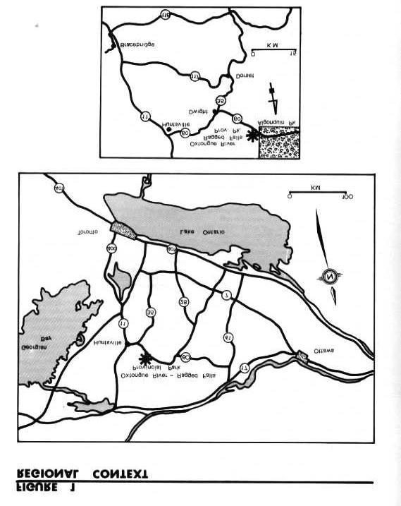
6 1.0 INTRODUCTION Oxtongue River-Ragged Falls Provincial Park protects one of Ontario s significant waterway corridors. The park includes 382 hectares of land and water along the Oxtongue River, extending 6.7 kilometres from the west boundary of Algonquin Provincial Park westward to the site where the river crosses Highway 60. Located within Central Ontario, Oxtongue River-Ragged Falls Provincial Park is approximately 35 kilometres east of the Town of Huntsville along Highway 60. It is approximately 320 kilometres west of the City of Ottawa and 275 kilometres north of the City of Toronto (Figure 1). The park includes a portion of a scenic canoe route, which begins at Tea Lake in Algonquin Provincial Park and continues down the Oxtongue River, ending in Oxtongue Lake. Two waterfalls are included within the park boundaries: Ragged Falls, which has a vertical drop of approximately 25 metres over a horizontal distance of 200 metres; and High Falls, which has a vertical drop of 10 metres over a horizontal distance of 10 metres. The area was first recognized for its recreational value during the 1950 s. In 1953 and 1959, portions of the planning area, including much of the Crown land surrounding Ragged Falls, were placed under a Crown Reserve. The Ragged Falls Reserve was subsequently considered as a candidate in the perimeter recreation system program for Algonquin Park during the late 1960 s and early 1970 s. Although this program was later abandoned, there was continued interest in the Ragged Falls area. In 1983, the Oxtongue River and Ragged Falls viewing area was identified as a candidate Waterway park through the Ministry of Natural Resources Strategic Land Use Planning Program. It was subsequently brought into regulation as a provincial park in 1985 (Ontario Regulation Number 493/85). Oxtongue River-Ragged Falls Provincial Park lies within the Grenville Province of the Canadian Shield. The river marks the contact between two units or rock types: the biotite gneisses north of the river; and the amphibolite and biotite-horneblende gneisses south of the river. The Oxtongue River flows through an ancient glacial spillway, which drained meltwaters from the Algonquin Highlands into glacial Lake Algonquin. The river drains southwestward out of Algonquin Provincial Park, cascading over several waterfalls and rapids, including the spectacular Ragged Falls.Three broad physiographic units are identifiable within the park: undulating upland areas covered by a thin, sandy till; glaciofluvial and alluvial deposits associated with the former glacial spillway channel and the present meandering river channel; and extensive organic deposits which have developed in lowland areas. The vegetative communities of the park are broadly defined by these physiographic units. Sugar Maple (Acer saccharum) dominated forests are, for the most part, associated with the undulating upland areas. Mixtures of beech (Fagus grandtfolia), yellow birch (Betula alleghaniensis) and hemlock (Tsuga canadensis) are common in varying proportions. Hemlock is conspicuous on thin soiled and bare steep slopes and ridges but is also found on deeper water laid sands in close proximity to the river, with balsam fir (Abies balsamea) as an associate. Maple is also found on the well-drained fluvial sands and gravels. Wetland communities dominate the low-lying areas along the river. Thicket communities are typical. The extensive peatland area in the eastern section of the planning area supports black spruce (Pica mariana) dominated swamps and spahagnum moss covered bogs. The historical features of Oxtongue River-Ragged Falls Provincial Park are a tribute to the ingenuity and determination of those involved in the lumber industry during the late 1800 s. The Oxtongue River was once part of the Gilrnour Timber Route which was used briefly by the Gilmour Brothers to ship logs from the Canoe Lake area of Algonquin Provincial Park down to the Muskoka and Trent River systems and eventually to their mill in Trenton. Sparse remnants of log chutes and dams are still evident at Ragged Falls and High Falls. Existing development within the park is limited. A day use area, which includes a parking area, picnic facilities and a viewing area has been developed around Ragged Falls (Figure 2). The park has been managed according to an Interim Park Management Statement, which was prepared in 1985, pending completion of a Park Management Plan. The Oxtongue River-Ragged Falls Provincial Park Management Plan establishes detailed policy guidelines for the long-term development and management of the park. It considers all known issues and Ministry policies relevant to the park. This plan applies to the twenty year period 1990 to 2010, and provides the opportunity for review at 10 year intervals, or as necessary. 2.0 CLASSIFICATION Oxtongue River-Ragged Falls Provincial Park is classified as a Waterway park. Waterway parks incorporate 1
7 2

8 3
9 outstanding recreational water routes with representative natural features and historical resources to provide high quality recreational and educational experiences. In Ontario, provincial parks have been identified and evaluated for their contribution to the Parks System objectives through the Ministry of Natural Resources Strategic Land Use Planning Program. Targets to achieve these objectives have been established for each park in the respective District Land Use Guidelines. Parks are then classified according to the Provincial Parks Classification System, which ensures a permanent, distinctive, representative, varied and accessible system of parks throughout the province. 3.0 GOAL The goal of Oxtongue River-Ragged Falls Provincial Park is to protect the recreational river and its associated natural and cultural features, and to provide a variety of quality outdoor recreational experiences. 4.0 OBJECTIVES Oxtongue River-Ragged Falls Provincial Park will contribute to the four objectives of the Ontario Provincial Park System. The objectives for the park are: 4.1 Protection To protect significant elements of the natural and cultural landscape of Ontario specifically, life science and historical features of regional significance, and earth science features of local significance. For park system planning purposes, the Ontario landscape is divided into 65 site districts based on criteria of biological productivity and landforms. The Oxtongue River-Ragged Falls area is situated in Site District 9, the Algonquin Park Site District. The park will contribute to the achievement of the Waterway class target for Site District 9. It also contributes to the achievement of Provincial Park protection targets by protecting life science and historical features of regional significance and earth science features of local significance. 4.2 Recreation To provide provincial park outdoor recreation opportunities specifically, low intensity day use experiences. Oxtongue River-Ragged Falls Provincial Park will provide a variety of low intensity recreational opportunities on a seasonal basis. Targets, established in the Bracebridge District Land Use Guidelines, to be provided annually by the year 2000, include 71,000 swimming opportunities, 26,000 picnicking opportunities and 1,000 backcountry opportunities. The park will contribute to the achievement of 1,500 day use and backcountry recreation opportunities annually. 5.3 Heritage Appreciation To provide opportunities for exploration and appreciation of the outdoor natural and cultural heritage of Ontario. Oxtongue River-Ragged Falls Provincial Park will provide the opportunity for the exploration and appreciation of its natural and cultural resources in an unstructured manner by way of self-use interpretive facilities and information. 4.4 Tourism To provide Ontario s residents and out-of-province visitors with opportunities to discover and experience the distinctive regions of the province. Oxtongue River-Ragged Falls Provincial Park will provide day use and backcountry recreation opportunities to Muskoka and Haliburton area residents, cottagers and the vacationing public. The park will complement existing provincial facilities in the area, including Algonquin Provincial Park and Arrowhead Provincial Park. It will provide an added attraction to assist local area tourism. 5.0 PARK BOUNDARY The park boundaries are generally positioned 200 metres in perpendicular distance from the high water mark along the shores of the Oxtongue River. The boundary extends beyond the 200 metre limit at the south west of the park to provide for the day use area at Ragged Falls (Figure 2). The park does not include four parcels of patented land along the westerly shore of the Oxtongue River at Highway 60. Here, the boundary follows the high water mark of the river adjacent to the patented land. One parcel of patented land, 0.3 hectares in area, is located within the park in Lot 12, Concession I of Finlayson, Township of Lake of Bays. The Ministry of Natural Resources does not plan to acquire any lands in the park area within the foreseeable future. However, the Ministry would entertain proposals of trade, donations or purchase of properties that would be of significant benefit to the park. 4

10 5
11 6.0 ZONING The establishment of zones is essential to the orderly development and effective management of the park. Zoning recognizes that every park includes a particular combination of resources, features and potential recreational experiences. It allocates the park s land base on the basis of the significance for protection and the potential for recreation within the context of the park s classification. The parks in each class combine zones in a particular way to provide protection and recreation opportunities distinctive to that class. Waterway parks may include Development, Access, Natural Environment, Historical, Nature Reserve and Wilderness Zones. Oxtongue River-Ragged Falls Provincial Park includes Development, Access and Natural Environment zones (Figure 3). 6.1 Development Zone (25 ha) Development zones provide access to the waterway and accommodate services and facilities for a wide range of recreational activities. The Development zone is centred around the Ragged Falls Viewing Area. It accesses a very popular and attractive waterfall feature and provides day use facilities accessory to this feature including a parking area, a picnic area, a minor trail system and viewing area. 6.2 Access Zone (4 ha) Access zones serve as staging areas where minimum facilities support the use of less developed portions of the water route. The Access zone will provide access to the Oxtongue River from the east boundary of the park for visitors who wish to travel the length of the park. Facilities will be limited to an access road, parking area and launching area for canoes and small boats. 6.3 Natural Environment Zone (353 ha) Natural Environment zones include aesthetic sections of the river corridor in which minimum development would be required to support low intensity recreational water travel activities. The majority of the park will be zoned Natural Environment. This zone includes much of the highly irregular topography of t he western section of the park. Here, tolerant coniferous forests of eastern hemlock and white cedar (Thuja occidentalis) dominate the ravine slopes and wet depressions, whereas the highland supports tolerant deciduous and mixed forests of sugar maple, eastern hemlock, and yellow birch in rich, sandy loam soils. The extensive wetland area of the eastern section of the zone supports a lowland bog forest of black spruce surrounded with balsam fir. Ragged Falls and High Falls are notable not only for their scenic value, but also for their historic value. There are sparse remains of log chutes and darns at both sites that are reminiscent of the log drives down the Oxtongue River at the turn of the century. The extensive wetland complex contains a variety of interesting flora and fauna. Although considered typical for the Site District, it is by its nature sensitive to development. These features are not considered to require distinctive management efforts. However, to maintain the existing aesthetic values of t hese features, recreational development in this zone will be restricted to facilities associated with backcountry recreation. 7.0 RESOURCE MANAGEMENT POLICIES 7.1 Vegetation Vegetation will be managed to complement aesthetic values, wildlife habitat and interpretation efforts while providing for safe and enjoyable recreational uses, in accordance with the planning policies for Waterway parks. A vegetation management plan may be prepared if the need arises. Commercial forest operations will not be permitted in the park. Trees removed for development and management purposes may be marketed or used for park purposes. Non-native plant species will not be deliberately introduced. Fertilizers may not be used except in the Development zone and Access zone. All forest fires will be suppressed. The fire suppression techniques used will have as minimum an effect as possible on the environment. Techniques such as bulldozing and water bombing with chemical additives will not generally be permitted except in critical situations as determined by the Park Superintendent or District Manager in cooperation with the Regional Fire Coordinator. Fire protection is provided by the Ministry s Bracebridge District. The park is included in the intensive Protection Zone 2B of the Bracebridge District Wild Fire Prevention Plan. This zone includes areas of high value, low hazard and low risk. Insects and diseases threatening park values will be 6
12 controlled where feasible. Where control is desirable, it will be directed as narrowly as possible to the specific pest so as to have minimal effect on other components of the park s environment. Biological control will be used whenever feasible. 7.2 Fisheries Sport fishing is permitted in Oxtongue River-Ragged Falls Provincial Park. The Oxtongue River will be managed as ~ marginal, self-sustaining brook trout fishery in accordance with the Bracebridge District Fisheries Management Plan. 7.3 Wildlife Animal populations may be controlled when essential to protect human health and safety or the health of the species inside or outside the park. Where control is desirable, techniques will be used having minimal effects on other components of the park s environment. Control measures will be carried out under the supervision of, or directly by, the Ministry of Natural Resources. Non-native animal species will not be introduced into the park Sport Hunting In Oxtongue River-Ragged Falls Provincial Park hunting will be permitted only in the Natural Environment zone Hunt Camps The hunt camp in Oxtongue River-Ragged Falls Provincial Park will be phased out over a twenty-one year period, effective January 1, No new hunt camps will be authorized within the park. A Land Use Permit will be issued on an annual basis, subject to compliance with the conditions of the permit, for the hunt camp located in Lot 18, Concession I of Finlayson, Township of Lake of Bays, to and including the year Commercial Trapping Commercial trapping will be phased out of Oxtongue River-Ragged Falls Provincial Park over a twenty-one year period, effective January 1,1989, or when the two currently registered trappers cease operation. No new traplines will be established within the park. A Letter of Permission will be issued annually, to the current registered trappers of trapline BR 05 N018 and BR for use of those areas within the park boundaries, up to and including the year Landforms Minerals and Mineral Aggregates The exploration or extraction of minerals or aggregates will not be permitted within the park. Where aggregate is required for development, maintenance or improvement of park facilities, it will be imported from external sources Water Resources and Control Water control structures such as dams or dykes will not be permitted in the park. Water levels in the park will continue to be monitored and controlled by a dam at Tea Lake. 8.0 OPERATIONS POLICIES A Park Operating Plan will be prepared to provide park staff with the necessary information required to operate the park on a day -to-day basis. In addition to addressing the operations policies, which follow, the plan will include such topics as budgeting, staffing, maintenance schedules, enforcement and emergency services. The provisions of the plan will be consistent with the approved Ontario Provincial Operating Standards, and will be reviewed annually and updated as required. 8.1 Visitor Services Oxtongue River-Ragged Falls Provincial Park will offer a self-use level Activity Visitor Services Program. Major facilities will not be provided. However, personal exploration of the park and the surrounding area will be encouraged using a self-guided approach Information A high quality public information service using print and display material will be developed. This service will highlight the park and the surrounding by providing information on significant natural and cultural features, park facilities, recreational opportunities, river travel, and safety tips and park user ethics. The service will be centred in the Development zone at the Ragged Falls Viewing Area and will include a park map, display board and brochure Interpretation The interpretive program for Oxtongue River-Ragged Falls Provincial Park will provide visitors with the opportunity to learn about and discover the area s unique natural and cultural heritage. Interpretive themes will include: 7
13 the historical expeditions of early explorers including Lieutenant Henry Briscoe, Alexander Shirreff, and David Thompson; the historical use of the Oxtongue River for log driving, including the construction and use of the Gilmour Tramway, the Gilmour Mill at Canoe Lake, water control and logging in and around Tea Lake, and the subsequent use of the river by other lumber companies, notably Mickle and Dyment and J.D. Shier; the earth and life science features of the park; and the role of the park in Ontario s Park System. The interpretive program will encourage individual and unstructured exploration of the park. The brochure and display board will focus on the interpretive themes and provide the medium for expressing the message of the interpretive program Recreation Oxtongue River-Ragged Falls Provincial Park will offer excellent opportunities for picnicking and other day use activities at the Ragged Falls Viewing Area. The river provides an interesting and varied boating experience for the recreational boater or canoeist. 8.2 Research Research by qualified individuals, which contributes to the knowledge of our natural and cultural history and to the environmental and recreational management of our waterways, will be encouraged in the park. All research programs will require prior written approval of the Ministry of Natural Resources and must also meet all requirements under applicable provincial and federal legislation. Approved research activities and facilities will be compatible with the protection values and the recreational uses of the park, and will be subject to the development and management policies detail herein, unless special permission is otherwise granted. 8.3 Recreation Management To ensure the continued high level of service offered at the park, a regular grounds maintenance program will continue. This will include garbage pickup, cleaning of sanitary facilities, annual removal of hazard trees, and grading of the access road and parking lot. In the past, the Ragged Falls Viewing Area has experienced minor visitor related problems, such as over-use of the trail network and minor vandalism of the rock face. These problems have been recognized and management strategies, such as adding woodchips to the trail system, have been put in place. The present program to monitor and manage these facilities will be continued. Motor vehicles or all terrain vehicles as defined in the Provincial Parks Act, will be permitted in the park only on designated roads, except where required for park management purposes and except where stated in Section 9.1 of this Plan. Snowmobiles will be permitted on the western access road through the gravel pit and on the access road and trail leading to Ragged Falls. 8.4 Marketing In order to realize the recreation potential of Oxtongue River-Ragged Falls Provincial Park and complement the local tourist economy, a Marketing Strategy will be prepared for the park. The strategy will include the following objectives: to attract day visitors staying at local commercial establishments or nearby provincial parks; to attract day visitors from local urban centres and private cottages; to attract visitors during low use periods in the mid-week and the shoulder seasons; to increase involvement with the commercial sector by encouraging park visitors to use local services and facilities; and to generally stimulate interaction between the park and the private tourist and commercial sector in the vicinity. 9.0 DEVELOPMENT POLICIES New development within the park will be minimal and consistent with the goals and objectives of a Waterway class park. Existing facilities will be maintained, and where deemed necessary, upgraded to maintain a high quality recreational experience. Development will proceed in accordance with Figure 4 and the following guidelines. In all instances, detailed site plans will be completed and approved in advance of renovation of existing facilities or development of new facilities. Development projects will be phased in according to the priorities established in Section 10.0, Implementation Strategy. A demonstrated need and the availability of funds will determine the exact timing of development. All development will adhere to the requirements of the Environmental Assessment Act. 8
14 9.1 Access and Parking One minor access point will be constructed within the park in the Access zone. Development of the Access zone will include an access road from Highway 60 at a location approved by the Ministry of Transportation, parking facilities with a total capacity for ten cars, privies and garbage disposal facilities. Boat launching facilities at the site will be minimal to encourage the use of canoes and small engine motor boats. The access road and parking facilities at the Ragged Falls Viewing Area will be maintained at their present level of service, providing parking spaces for twenty cars. Further to Section 8.3 of this plan, the following provisions will apply to the use of all other roads within Oxtongue River Ragged Falls Provincial Park. Forest access roads will not be permitted; The western access road through the gravel pit -the road will remain open for public use by motor vehicles; The trail immediately east of the access road to Ragged Falls - use of the trail by all terrain vehicles for the purpose of boat launching and removal will be permitted during the deer and moose season only. Permission will be granted by an annual Letter of Permission from the Park Superintendent to hunt camp members; The road to the private parcel, Lot 12, Concession I, Finlayson, Township of Lake of Bays - use of the road by motor vehicles, by the owners of the private parcel or their guests will be permitted; The road to the Oxtongue River Hunt Club and to the north side of Oxtongue River - public use of the road will be permitted from October 1st to and including November 30th. Use of the road by the registered trappers of trapline BR 05 NO18 and BR will be authorized annually by a Letter of Permission; All other uses of roads within the park will occur only with the written permission of the Park Superintendent. 9.2 Day Use Area Facilities at the Ragged Falls Viewing Area will be maintained at their present level of service. Consideration may be given to an expansion of the picnic facilities should the need arise in the future. This need will be based upon the overall level of use, substantiated by demand indicators such as general requests and use surveys. A small dock will be installed at the base of Ragged Falls to assist canoeists in departing and landing. The dock will be situated at an inconspicuous site so as not to interfere with viewing opportunities from the top of the falls. A sign, which identifies Oxtongue River-Ragged Falls Provincial Park will be designed and situated at the highway entrance to the Ragged Falls Viewing Area. An information display area will be developed at the day use area to provide visitors with information on the park and its features. 9.3 Facilities for Park Administration and Operation The park administration facilities will not be located on site. Staff, centred at Arrowhead Provincial Park, will plan routine visits to Oxtongue River-Ragged Falls Provincial Park to ensure the orderly operation and maintenance of the park and its recreational facilities IMPLEMENTATION PRIORITIES The management plan will be reviewed every ten years following its approval or as the need arises. Data collection and environmental monitoring will be conducted regularly. The following is a list of projects that have been identified in this plan. The list appears in chronological order according to the individual project priority. The completion of projects will depend on the availability of necessary funding and as increased recreational use warrants. Priority Rating Project Description 1 Develop Site Plans for proposed facilities at the Development and Access zones 2 Develop and upgrade the Development zone a) upgrade parking lot and sanitary facilities b) design and position park sign c) construct canoe dock at base of Ragged Falls d) develop visitor information service, including display board and park brochure 3 Develop a Park Operating Plan 4 Develop the Access zone a) construct new access road and parking lot b) provide basic boat launching facilities c) provide privies and garbage disposal system d) design and position sign 5 Develop a Marketing Strategy 9
15 10
16 11.0 PUBLIC CONSULTATION The park management planning process was initiated in November of Public notification of the process was given, at that time, in the local newspapers. In January of 1989, a report which compiles the background information for the park was made available to the public. A newsletter summarizing this information and requesting public comment was distributed to all those on the park s mailing list. The general public was notified by advertisements in local newspapers. The Preliminary Management Plan was made available to the public in early April, A second newsletter, summarizing the plan and inviting the public to discuss the plan with the Planning Committee at an Open House, was distributed to all those on the park s mailing list. The general public was notified by a news release and advertisements placed in local newspapers. The Acting Parks Supervisor was interviewed by a local radio station and the Parks Superintendent was interviewed by a local television station. The Open House was held April 28 and 29, 1989 in the Town of Huntsville. Most participants were in general agreement with the Preliminary Management Plan. Concern was expressed by area hunters over restrictions on traditional hunting areas and access to traditional hunting areas. Detailed provisions were then added to permit controlled use by motor vehicles on existing roads and trails within the park as detailed in Section 9.1. The concerns identified through public consultation are discussed in detail in a report Oxtongue River-Ragged Falls Provincial Park, Park Management Plan, Summary of Public Response. This report and copies of all public input are available for review at the Bracebridge District Office. The Park Management Plan for Oxtongue River-Ragged Falls Provincial Park is a refinement of the Preliminary Park Management Plan. It addresses the issues raised through public consultation and resolves these issues within the context of applicable legislation, Ministry policies and sound resource management principles. 11
17 12.0 REFERENCES Brunton, D.F. Life Science Areas of Natural and Scientific Interest in Site District 54. Unpublished Report, Parks and Recreational Areas Section, O.M.N.R., Algonquin Region, Huntsville, Edwards, R. Historical Resource Inventory of Ragged Falls Reserve, Volume 1, Unpublished Report, O.M.N.R., Parks and Recreational Areas Branch, Algonquin Region, Huntsville, Environment Canada. Canadian Climate Normals Atmospheric Environment Service, Canadian Climate Program, Ottawa, Hills, G.A. A Ready Reference to the Description of the Land of Ontario and its Productivity, Ontario Department of Lands and Forests, Division of Research, Maple, Recreation Areas Branch, Toronto, Ross W., and D. Ragged Falls Area, Archaeological Resource Inventory, Unpublished Report, O.M.N.R., Parks and Recreation Areas Branch, Algonquin Region, Rowe, J.S. Forest Regions of Canada, Bulletin No. 123, Department of Northern Affairs and National Resources, Forestry Branch, Ottawa, Showkewych-Hanna, R. Preliminary Botanical Inventory of the Ragged Falls Study Area, Environmental Planning Series VI, 20, O.M.N.R., Parks Planning Branch, Toronto, Martin, P. Oxtongue River-Ragged Falls Provincial Park, Compilation of Background Information Unpublished Report, O.M.N.R., Bracebridge District, Ontario Ministry of Natural Resources. Access Guidelines Management Area C, Braacebridge District, Unpublished Report, Bracebridge District, (0.25 k P.R., ) ISBN Ontario Ministry of Natural Resources. Backgrounder. Land Use Guidelines, Toronto, Ontario Ministry of Natural Resources. Braacebridge District Fisheries Management Plan , Queen s Printer for Ontario, Queen s Park, Ontario Ministry of Natural Resources. Bracebridge District Land Use Guidelines, Lands Branch, Algonquin Region, Ontario Ministry of Natural Resources. Earth Science Checksheets for Bracebridge District Parks, Park Reserves and Proposals Parks and Recreation Areas Branch, Algonquin Region, Ontario Ministry of Natural Resources. Life Science Checksheets for Bracebridge District Parks, Park Reserves and Proposals, Parks and Recreation Areas Branch, Algonquin Region, 1979, revised Ontario Ministry of Natural Resources. Ontario Provincial Parks Management Planning Reference, Parks and Recreation Areas Branch, Toronto, Ontario Ministry of Natural Resources. Ontario Provincial Parks Planning and Management Policies Parks and 12
Approval Statement. Brian Pfrimmer, Central Zone Manager Ontario Parks
 Approval Statement I am pleased to approve this Interim Management Statement for Dividing Lake Provincial Nature Reserve. This Nature Reserve contains biological features of provincial significance and
Nakina Moraine Provincial Park. Interim Management Statement. Ontario. Ministry of Natural Resources
 Nakina Moraine Provincial Park Interim Management Statement Ontario Ministry of Natural Resources 1999, Queen's Printer for Ontario Printed in Ontario, Canada Additional copies of this publication can
NOV UPPER MADAWASKA RIVER PROVINCIAL PARK INTERIM MANAGEMENT STATEMENT. Ontario
 NOV 1 3 2001 UPPER MADAWASKA RIVER PROVINCIAL PARK INTERIM MANAGEMENT STATEMENT Ontario . BACKGROUND INFORMATION NAME: Upper Madawaska River REGIONAL SETTING MAP PROPOSED CLASS: U.N.R. DISTRICT: U.N.R.
Dividing Lake Provincial Nature Reserve
 - Do Not Remove i, '" i ' Dividing Lake Provincial Nature Reserve I!.' Interim Management Statement Amendment 2001-001 Park Boundary Amendment Approved: r.in'r entral Zone, Ontario Parks PJ Date 2. ()/
Steel River Provincial Park. Interim Management Statement. Ministry of Natural Resources. Ontario. Ministry of Natural Resources.
 Steel River Provincial Park Interim Management Statement Ontario Ministry of Natural Resources (j) Ontario Ministry of Natural Resources Additional copies of this publication are obtainable only from:
ISBN c 1988 Government of Ontario Printed in Ontario, Canada
 Single copies of this publication are available for $2.00 from the Ontario Ministry of Natural Resources, Espanola District Office, P.O. Box 1340, 148 Fleming Street, Espanola, Ontario, POP 1CO, telephone:
Ouimet Canyon Provincial Nature Reserve. Management Plan
 Ouimet Canyon Provincial Nature Reserve Management Plan NOTE: This document has been scanned and formatted, and therefore is slightly different from the original version. -March 2002 Additional copies
MANAGEMENT DIRECTION STATEMENT June, 1999
 Thompson River District MANAGEMENT DIRECTION STATEMENT June, 1999 for Clearwater River Corridor (Addition to Wells Gray Park) Ministry of Environment Lands and Parks BC Parks Division ii Table of Contents
Yard Creek Provincial Park. Management Plan
 Yard Creek Provincial Park Management Plan Draft January 2010 Yard Creek Provincial Park Management Plan Approved by: telàlsemkin/siyam/chief Scott Benton Bill Williams Squamish Executive Director ation
White Lake Peatlands. Interim Management Statement
 White Lake Peatlands Interim Management Statement 2007 APPROVAL STATEMENT I am pleased to approve this Interim Management Statement for White Lake Peatlands Provincial Park. This park was regulated under
MANAGEMENT DIRECTION STATEMENT June, 1999
 Thompson River District MANAGEMENT DIRECTION STATEMENT June, 1999 for Roche Lake Provincial Park Ministry of Environment Lands and Parks BC Parks Division Table of Contents I. Introduction A. Setting
MacMurchy Township End Moraine. Interim Management Statement
 MacMurchy Township End Moraine Interim Management Statement 2006 Approval Statement I am pleased to approve this Interim Management Statement for MacMurchy Township End Moraine Provincial Park (P1591).
 March 25, 1994 To: Re: MEMO TO FILE MINOR AMENDMENT - PINERY PROVINCIAL PARK MANAGEMENT PLAN The following paragraph from page 5 of the Pinery Provincial Park Management Plan (ISBN 0-7729-0290-9) lnsects
As outlined in the Tatshenshini-Alsek Park Management Agreement, park management will:
 Management Strategy General Strategy The priority management focus for the park is to ensure that its internationally significant natural, cultural heritage and recreational values are protected and that
Port Bruce. Interim Management Statement
 Port Bruce Interim Management Statement Port Bruce Interim Management Statement August 3, 1999 This Port Bruce Provincial Park Interim Management Statement provides direction for the custodial management
Ontario. Tide Lake Provincial Nature Reserve. Interim Management Statement. Ministry of Natural Resources
 Ontario Tide Lake Provincial Nature Reserve nterim Management Statement Ministry of Natural Resources Tide Lake Provincial Nature Reserve nterim Management Statement Ontario Ministry of Natural Resources
Boyne Valley Provincial Park. Interim Management Statement
 Boyne Valley Provincial Park Interim Management Statement January 20, 1995 REGIONAL DIRECTOR'S APPROVAL STATEMENT This Interim Management Statement will provide interim direction for the management of
PARK MANAGEMENT PLANNING SERIES STURGEON BAY PROVINCIAL PARK MANAGEMENT PLAN
 PARK MANAGEMENT PLANNING SERIES STURGEON BAY PROVINCIAL PARK MANAGEMENT PLAN MNR 3477 ISBN 0 7729 1018 9 1986 Government of Ontario Limited copies of this publication are obtainable at the Ministry of
Samuel de Champlain Provincial Park Management Plan
 Samuel de Champlain Provincial Park Management Plan Ontario Ministry of Natural Resources Cover Photo: Tracking the Rapids c. 1891 (detail) Francis Anne Hopkins (1838-1919) Sigmund Samuel Collection, Royal
Seager Wheeler Lake. Representative Area. -- Concept Management Plan --
 Seager Wheeler Lake Representative Area -- Concept Management Plan -- Saskatchewan Environment and Resource Management January, 1999 Saskatchewan s Representative Areas Network Program The Government of
Bayview Escarpment. Interim Management Statement
 Bayview Escarpment Interim Management Statement Bayview Escarpment Provincial Nature Reserve Interim Management Statement January 15, 1995 REGIONAL DIRECTOR'S APPROVAL STATEMENT This Interim Management
ANAGEMENT. LAN November, 1996
 M ANAGEMENT P LAN November, 1996 for Paul Lake Provincial Park Ministry of Environment, Lands and Parks BC Parks Department Paul Lake Provincial Park M ANAGEMENT P LAN Prepared by BC Parks Kamloops Area
We are pleased to approve the Craigleith Provincial Park Management Plan, as official policy for the management and development of this park.
 We are pleased to approve the Craigleith Provincial Park Management Plan, as official policy for the management and development of this park. The plan reflects this Ministry s intent to protect natural
Marchand Provincial Park. Management Plan
 Marchand Provincial Park Management Plan 2 Marchand Provincial Park Table of Contents 1. Introduction... 3 2. Park History... 3 3. Park Attributes... 4 3.1 Natural... 4 3.2 Recreational... 4 3.3 Additional
Ojibway Provincial Park. Management Plan
 Ojibway Provincial Park Management Plan ISBN O-7729-9448-X 1992, Queen s Printer for Ontario Printed in Ontario, Canada Single copies of this publication are available at no charge from the address noted
Wallace Lake Provincial Park. Management Plan
 Wallace Lake Provincial Park Management Plan 2 Wallace Lake Provincial Park Table of Contents 1. Introduction... 3 2. Park History... 3 3. Park Attributes... 4 3.1 Natural... 4 3.2 Recreational... 4 4.
A GUIDE TO MANITOBA PROTECTED AREAS & LANDS PROTECTION
 A GUIDE TO MANITOBA PROTECTED AREAS & LANDS PROTECTION Manitoba Wildands December 2008 Discussions about the establishment of protected lands need to be clear about the definition of protection. We will
Clearwater Lake Provincial Park. Draft Management Plan
 Clearwater Lake Provincial Park Draft Management Plan Clearwater Lake Provincial Park Draft Management Plan Table of Contents 1. Introduction... 3 2. Park History... 4 3. Park Attributes... 4 3.1 Location/Access...4
2.1 Physical and Biological Description Matabitchuan River Watershed
 2.1 Physical and Biological Description Watershed 2.1.1 Physical Description The system watershed has a total area of about 933 km 2 and is a tributary system to Lake Temiskaming and the Ottawa River Drainage
Lion s Head. Interim Management Statement
 Lion s Head Interim Management Statement Lion's Head Provincial Nature Reserve Interim Management Statement July 14, 1997 APPROVAL STATEMENT This Interim Management Statement will provide interim direction
Pembina Valley Provincial Park. Draft Management Plan
 Pembina Valley Provincial Park Draft Management Plan 2 Pembina Valley Provincial Park Table of Contents 1. Introduction... 3 2. Park History... 3 3. Park Attributes... 3 3.1 Natural... 3 3.2 Recreational...
Watchorn Provincial Park. Management Plan
 Watchorn Provincial Park Management Plan 2 Watchorn Provincial Park Table of Contents 1. Introduction... 3 2. Park History... 3 3. Park Attributes... 3 3.1 Natural... 4 3.2 Recreational... 4 3.3 Additional
PROUDLY BRINGING YOU CANADA AT ITS BEST. Management Planning Program NEWSLETTER #1 OCTOBER, 2000
 PROUDLY BRINGING YOU CANADA AT ITS BEST VUNTUT NATIONAL PARK Management Planning Program NEWSLETTER #1 OCTOBER, 2000 INTRODUCTION This newsletter launches the development of the first management plan for
ROBERTS CREEK PROVINCIAL PARK MASTER PLAN. November, 1981
 Ministry of Lands, Parks and Housing Parks and Outdoor Recreation Division Park Operations Branch North Vancouver, B. C. ROBERTS CREEK PROVINCIAL PARK MASTER PLAN November, 1981 Mr. G. Trachuk Director
Sasagiu Rapids Provincial Park. Draft Management Plan
 Sasagiu Rapids Provincial Park Draft Management Plan 2 Sasagiu Rapids Provincial Park Table of Contents 1. Introduction... 3 2. Background and Park Attributes... 3 2.1 Park History.... 3 2.2 Natural Features...
Whitemouth Falls Provincial Park. Draft Management Plan
 Whitemouth Falls Provincial Park Draft Management Plan Whitemouth Falls Provincial Park Draft Management Plan Table of Contents 1. Introduction... 3 2. Park History... 3 3. Park Attributes... 4 3.1 Natural...
MANAGEMENT DIRECTION STATEMENT March 2003
 Skeena Region MAAGEMET DIRECTIO STATEMET March 2003 for Meziadin Lake Provincial Park Ministry of Water, Land and Air Protection Environmental Stewardsh Division This page left blank on purpose ii Table
Wallace Lake Provincial Park. Draft Management Plan
 Wallace Lake Provincial Park Draft Management Plan Wallace Lake Provincial Park Draft Management Plan Table of Contents 1. Introduction... 3 2. Park History... 3 3. Park Attributes... 4 3.1 Natural...
Hardy Lake Provincial Park Management Plan
 Hardy Lake Provincial Park Management Plan Hon. Vincent G. Kerrio Minister Mary Mogford Deputy Minister 3646 0 7729 1484 2 1986, Queen s Printer for Ontario Printed in Ontario, Canada Limited copies of
Longlac North Conservation Reserve (C2207) Statement of Conservation Interest
 Statement of Conservation Interest") Longlac North Conservation Reserve (C2207) Statement of Conservation Interest April 2003 Prepared for the Ontario Ministry of Natural Resources, Northwest Region by Rebecca Zeran and Natalie Kolody OLL
Longlac North Conservation Reserve (C2207) Statement of Conservation Interest April 2003 Prepared for the Ontario Ministry of Natural Resources, Northwest Region by Rebecca Zeran and Natalie Kolody OLL
Pillar Park. Management Plan
 Pillar Park Management Plan January 2014 Pillar Park Management Plan Approved by: Jeff Leahy Regional Director Thompson Cariboo Region BC Parks January 9, 2014 Date Brian Bawtinheimer Executive Director
SUMMER VILLAGE OF SILVER SANDS. Municipal Development Plan
 SUMMER VILLAGE OF SILVER SANDS Municipal Development Plan Bylaw 253-2014 Adopted August 22, 2014 Summer Village of Silver Sands Municipal Development Plan Bylaw No. 253-2014 Page 2 1 INTRODUCTION 1.1 SETTING
Noganosh Lake. Interim Management Statement
 Noganosh Interim Management Statement March 1, 2004 The Noganosh Provincial Park Interim Management Statement provides direction for the custodial management of Noganosh Provincial Park until such time
Pinawa Provincial Park. Draft Management Plan
 Pinawa Provincial Park Draft Management Plan Pinawa Provincial Park Draft Management Plan Table of Contents 1. Introduction... 3 2. Park History... 3 3. Park Attributes... 4 3.1 Natural... 4 3.2 Recreational...
5.0 OUTDOOR RECREATION OPPORTUNITIES AND MANAGEMENT
 5.0 OUTDOOR RECREATION OPPORTUNITIES AND MANAGEMENT 5.1 Introduction This section describes the range of recreational activities that currently take place in Marble Range and Edge Hills Parks, as well
Jocko Rivers. Interim Management Statement
 Jocko Rivers Interim Management Statement 2006 APPROVAL STATEMENT I am pleased to approve this Interim Management Statement for Jocko Rivers Provincial Park. Ontario s Living Legacy Land Use Strategy (OMNR
ANAGEMENT P LAN. February, for Elk Lakes and Height of the Rockies Provincial Parks. Ministry of Environment, Lands and Parks BC Parks Division
 M ANAGEMENT P LAN February, 1999 for Elk Lakes and Height of the Rockies Provincial Parks Ministry of Environment, Lands and Parks BC Parks Division Elk Lakes & Height of the Rockies Provincial Parks M
Mackinnon Esker Ecological Reserve Draft - Management Plan
 Mackinnon Esker Ecological Reserve Draft - Management Plan May 2011 Photo Credit: This document replaces the direction provided in the Carp Lake Provincial Park and Protected Area and Mackinnon Esker Ecological
Criddle/Vane Homestead Provincial Park. Management Plan
 Criddle/Vane Homestead Provincial Park Management Plan 2 Criddle/Vane Homestead Provincial Park Table of Contents 1. Introduction... 3 2. Park History.... 3 3. Park Attributes.... 4 3.1 Natural.... 4 3.2
2.0 PARK VISION AND ROLES
 2.0 PARK VISION AND ROLES 2.1 Significance in the Protected Area System Marble Range and Edge Hills provincial parks protect 6.8% of the Pavillion Ranges Ecosection, which is located in the Southern Interior
Birch Point Provincial Park. Management Plan
 Birch Point Provincial Park Management Plan 2 Birch Point Provincial Park Table of Contents 1. Introduction... 3 2. Park History... 3 3. Park Attributes... 4 3.1 Natural... 4 3.2 Recreational... 4 4. Park
Ontario s Approach to Wilderness: A Policy May 1997 (Version 1.0)
") Ontario s Approach to Wilderness: A Policy May 1997 (Version 1.0) 1.0. Introduction Wilderness is important to Ontarians, important to the sustained, healthy functioning of Ontario s ecosystems. The Ministry
Ontario s Approach to Wilderness: A Policy May 1997 (Version 1.0) 1.0. Introduction Wilderness is important to Ontarians, important to the sustained, healthy functioning of Ontario s ecosystems. The Ministry
Connie Rudd Superintendent, Black Canyon of the Gunnison National Park
 National Park Service U.S. Department of the Interior Black Canyon of the Gunnison National Park and Curecanti National Recreation Area Information Brochure #1 Wilderness and Backcountry Management Plan
MANAGEMENT DIRECTION STATEMENT
 Lower Mainland District MAAGEMET DIRECTIO STATEMET January 2001 for Liumchen Ecological Reserve Ministry of Environment Lands and Parks BC Parks Division Table of Contents Page Introduction... 1 Purpose
Appendix A BC Provincial Parks System Goals
 Appendix A BC Provincial Parks System Goals The British Columbia Provincial Parks System has two mandates: To conserve significant and representative natural and cultural resources To provide a wide variety
Portage Spillway Provincial Park. Draft Management Plan
 Portage Spillway Provincial Park Draft Management Plan 2 Portage Spillway Provincial Park Table of Contents 1. Introduction... 3 2. Park History... 3 3. Park Attributes... 4 3.1 Natural... 4 3.2 Recreational...
PLUMPER COVE MARINE PARK MASTER PLAN
 Lower Mainland Region Park Operations Branch Parks and Outdoor Recreation Division Ministry of Lands, Parks and Housing North Vancouver, B.C. PLUMPER COVE MARINE PARK MASTER PLAN DECEMBER, 1980 PLUMPER
Bradley Brook Relocation Project. Scoping Notice. Saco Ranger District. United States Department of Agriculture Forest Service
 Bradley Brook Relocation Project United States Department of Agriculture Forest Service Scoping Notice White Mountain National Forest February 2011 For Information Contact: Jenny Burnett White Mountain
Cavern Lake Provincial Nature Reserve. Management Plan
 Cavern Lake Provincial Nature Reserve Management Plan NOTE: This document has been scanned and formatted, and therefore is slightly different from the original version. - March 2002 Additional copies of
EXECUTIVE SUMMARY PROGRAM DEVELOPMENT REPORT PURPOSE EXISTING SETTING EXPANDING PARKLAND
 EXECUTIVE SUMMARY PROGRAM DEVELOPMENT REPORT PURPOSE As the culmination of the first phase of the master planning process, this Program Development Report creates the framework to develop the Calero County
MANAGEMENT DIRECTION STATEMENT
 Skeena District MAAGEMET DIRECTIO STATEMET July, 2000 for Driftwood Canyon Provincial Park Ministry of Environment Lands and Parks BC Parks Division i Table of Contents Driftwood Canyon Park Approvals
Numaykoos Lake Provincial Park. Management Plan
 Numaykoos Lake Provincial Park Management Plan 2 Numaykoos Lake Provincial Park Table of Contents 1. Introduction... 3 2. Background... 3 3. Park Purpose... 5 4. Park Management Guidelines... 6 Appendix...
camping means the temporary occupation of Crown land using a camping unit, but does not include commercial tourism occupations;
 Ontario Ministry of Natural Resources Subject FREE USE POLICY Compiled by - Branch Lands & Waters Section Land Management Policy PL 3.03.01 Replaces Directive Title Same title Number Same number Dated
Little Limestone Lake Provincial Park. Draft Management Plan
 Little Limestone Lake Provincial Park Draft Management Plan Little Limestone Lake Provincial Park Draft Management Plan Table of Contents 1. Introduction... 3 2. Background... 3 3. Planning context...
Ottertooth CONSERVATION RESERVE C2262 STATEMENT OF CONSERVATION INTEREST. Ministry of Natural Resources. Thunder Bay District.
 Ottertooth CONSERVATION RESERVE C2262 STATEMENT OF CONSERVATION INTEREST Ministry of Natural Resources Thunder Bay District January 2003 Information Management By Jason Biggar Thunder Bay District Ottertooth
Public Consultation Program Phase One Response. Pukaskwa National Park
 Public Consultation Program Phase One Response Pukaskwa National Park Parks Canada Parcs Canada In February, 1978, an agreement was signed between the Province of Ontario and the federal government creating
Geoscape Toronto The Oak Ridges Moraine Activity 2 - Page 1 of 10 Information Bulletin
 About 13,000 years ago as the Laurentide Ice Sheet melted, glacial meltwater accumulated between the ice sheet and the Niagara Escarpment. This formed a lake basin into which gravel and sand were deposited.
MASTER PLAN EXECUTIVE SUMMARY
 Biscuit Run State Park Scottsville Road (State Route 20) Charlottesville, VA 22902 Biscuit Run State Park MASTER PLAN EXECUTIVE SUMMARY Department of Conservation and Recreation Division of Planning and
Flow Stand Up Paddle Board Parkway Plan Analysis
 Regional Parks Department Jeffrey R. Leatherman, Director County of Sacramento Divisions Administration Golf Leisure Services Maintenance Rangers Therapeutic Recreation Services Flow Stand Up Paddle Board
Criddle/Vane Homestead Provincial Park. Draft Management Plan
 Criddle/Vane Homestead Provincial Park Draft Management Plan 2 Criddle/Vane Homestead Provincial Park Table of Contents 1. Introduction... 3 2. Park History.... 3 3. Park Attributes.... 3 3.1 Natural....
Proposed Ruisseau- Clinchamp ecological reserve
 Proposed Ruisseau- Clinchamp ecological reserve October 2003 1. Plan and description 1.1. Geographic location, boundaries and dimensions The plans of the boundaries of the proposed Ruisseau-Clinchamp ecological
MANAGEMENT DIRECTION STATEMENT October, 1999
 Thompson River District MAAGEMET DIRECTIO STATEMET October, 1999 for Wire Cache Provincial Park Ministry of Environment Lands and Parks BC Parks Division Ministry of Environment, Lands and Parks BC Parks
Sand Lakes Provincial Park. Draft Management Plan
 Sand Lakes Provincial Park Draft Management Plan 2 Sand Lakes Provincial Park Table of Contents 1. Introduction... 3 2. Background... 3 3. Park Purpose... 5 4. Park Management Guidelines... 6 Appendix...
FINGER-TATUK PROVINCIAL PARK
 FINGER-TATUK PROVINCIAL PARK PURPOSE STATEMENT AND ZONING PLAN March 2003 FINGER-TATUK PROVINCIAL PARK Purpose Statement and Zoning Plan Finger-Tatuk Provincial Park is 17,151 ha in size. It includes the
TRAILS WHERE TO FIND TRAILS IN NOVA SCOTIA
 TRAILs SIGNAGE Know the Signs............................ 44 WHERE YOU CAN RIDE Roads and Highways........................ 46 Designated Trails........................... 47 Established Trails...........................
TOURISM & PUBLIC SERVICES RURAL SIGNAGE POLICY
 Policy and Procedures Subject Title: Tourism and Public Services Rural Signage Policy Corporate Policy (Approved by Council): X Policy Ref. No.: ROADS-01-07 Administrative Policy (Approved by CAO): By-Law
FILE: /PERM EFFECTIVE DATE: May 16, 2014 AMENDMENT:
 APPROVED AMENDMENTS: Effective Date Briefing Note /Approval Summary of Changes: FILE: 11000-00/PERM EFFECTIVE DATE: May 16, 2014 AMENDMENT: Table of Contents 1. POLICY APPLICATION... 1 2. PRINCIPLES AND
White Mountain National Forest Saco Ranger District
 United States Department of Agriculture Forest Service White Mountain National Forest 33 Kancamagus Highway Conway, NH 03818 Comm: (603) 447-5448 TTY: (603) 447-3121 File Code: 1950 Date: February 26,
KANANASKIS COUNTRY PROVINCIAL RECREATION AREAS MANAGEMENT PLAN DRAFT TERMS OF REFERENCE - November 20, 2007
 KANANASKIS COUNTRY PROVINCIAL RECREATION AREAS MANAGEMENT PLAN DRAFT TERMS OF REFERENCE - November 20, 2007 BACKGROUND There are 42 Provincial Recreation Areas (PRAs) within Kananaskis Country located
Limestone Islands. Park Management Plan
 Limestone Islands Park Management Plan MNR 51643-1 ISBN 0-7794-3580-X 2002 Queen s Printer of Ontario Printed in Ontario, Canada Cover Photo: Henry Kujala Additional copies of this publication can be obtained
MAIN LAKE PROVINCIAL PARK
 MAIN LAKE PROVINCIAL PARK PURPOSE STATEMENT AND ZONING PLAN March 2003 MAIN LAKE PROVINCIAL PARK Purpose Statement and Zoning Plan Primary Role The primary role of Main Lake Park is to protect a biologically
MARBLE RIVER PROVINCIAL PARK
 MARBLE RIVER PROVINCIAL PARK PURPOSE STATEMENT AND ZONING PLAN March 2003 MARBLE RIVER PROVINCIAL PARK Purpose Statement and Zoning Plan Primary Role The primary role of Marble River Park is to protect
Blueways: Rivers, lakes, or streams with public access for recreation that includes fishing, nature observation, and opportunities for boating.
 Parks, Open Space and Trails PRINCE WILLIAM COUNTY 2008 COMPREHENSIVE PLAN TRAILS PLAN CONTENTS The components of the trails plan are: Intent Definitions Goals, Policies, and Action Strategies Trails Map
Recreation Opportunity Spectrum for River Management v
 Recreation Opportunity Spectrum for Management v. 120803 Introduction The following Recreation Opportunity Spectrum (ROS) characterizations and matrices mirror the presentation in the ROS Primer and Field
VARGAS ISLAND PROVINCIAL PARK
 VARGAS ISLAND PROVINCIAL PARK PURPOSE STATEMENT AND ZONING PLAN February 2003 VARGAS ISLAND PROVINCIAL PARK Purpose Statement and Zoning Plan Primary Role The primary role of Vargas Island Park is to protect
Dragon Mountain Park. Management Plan. Public Review Draft
 Disclaimer: This draft management plan contains preliminary proposals that are subject to change and therefore may not necessarily reflect the position of the Ministry of Environment. At the conclusion
SPECTACLE LAKE PROVINCIAL PARK PURPOSE STATEMENT AND ZONING PLAN
 SPECTACLE LAKE PROVINCIAL PARK PURPOSE STATEMENT AND ZONING PLAN August 2003 1 SPECTACLE LAKE PROVINCIAL PARK Purpose Statement and Zoning Plan Primary Role The primary role of Spectacle Lake Park is to
MANAGEMENT DIRECTION STATEMENT March 2003
 Skeena Region MAAGEMET DIRECTIO STATEMET March 2003 for Lava Forks Provincial Park Ministry of Water, Land and Air Protection Environmental Stewardshi Division This management direction statement was
BACKCOUNTRY TRAIL FLOOD REHABILITATION PROGRAM
 BACKCOUNTRY TRAIL FLOOD REHABILITATION PROGRAM Backcountry Trail Flood Rehabilitation A June 2013 Flood Recovery Program Summary In June 2013, parts of Southern Alberta were devastated from significant
Temagami Area Provincial Parks
 Temagami Area Provincial Parks Lady Evelyn-Smoothwater Makobe-Grays River Obabika River Solace Sturgeon River Preliminary Park Management Plan Temagami Area Backcountry Parks DRAFT Preliminary Park Management
Segment 2: La Crescent to Miller s Corner
 goal of the USFWS refuges is to conserve, protect and enhance fish, wildlife and plants and their habitats for the continuing benefit of the American people. Refuge lands are used largely for fishing,
MANAGEMENT DIRECTION STATEMENT October, 1999
 Thompson River District MAAGEMET DIRECTIO STATEMET October, 1999 for Chu Chua Cottonwood Provincial Park Ministry of Environment Lands and Parks BC Parks Division Ministry of Environment, Lands and Parks
Continental Divide National Scenic Trail Legislative History and Planning Guidance
 Continental Divide National Scenic Trail Legislative History and Planning Guidance Legislation, Policy, and Direction Regarding National Scenic Trails The National Trails System Act, P.L. 90-543, was passed
South Atikaki Provincial Park. Draft Management Plan
 South Atikaki Provincial Park Draft Management Plan South Atikaki Provincial Park Draft Management Plan Table of Contents 1. Introduction... 3 2. Park History... 3 3. Park Attributes... 3 3.1 Natural...
Preferred Recreation Recommendations Stemilt-Squilchuck Recreation Plan March 2018
 Preferred Recreation Recommendations Stemilt-Squilchuck Recreation Plan March 2018 Below are the recommended recreation ideas and strategies that package together the various recreation concepts compiled
Winnipeg Beach Provincial Park. Draft Management Plan
 Winnipeg Beach Provincial Park Draft Management Plan 2 Winnipeg Beach Provincial Park Table of Contents 1. Introduction... 3 2. Park History... 3 3. Park Attributes... 4 3.1 Natural...4 3.2 Recreational...4
Conservation Area Management Statement
 Conservation Area Management Statement Miller Creek Wildlife Area Resolution #: Approval: Issue Date: Date of Last Revision: Table of Contents 1. Purpose....... 1 2. Property Description...... 1 2.1. Legal
1 INFORMATION REQUIREMENTS
 1 INFORMATION REQUIREMENTS 1.1 BACKGROUND 2 1.2 WHAT IS THE DISTRICT PLAN 3 1.3 DISTRICT PLAN STRUCTURE 4 1.4 HOW TO USE THE DISTRICT PLAN 5 1.5 STRATEGIC FRAMEWORK 6 Whanganui District Plan (15 January
How should the proposed protected area be administered and managed?
 SPERRGEBIET CONSERVATION PLANNING Questionnaire In big words the main objectives of this questionnaire are to contribute to: 1. finding approaches and mechanism for implementing a multi-use protected area
River aux Sables. Interim Management Statement
 River aux Sables Interim Management Statement 2006 APPROVAL STATEMENT I am pleased to approve this Interim Management Statement for River aux Sables Provincial Park. Ontario s Living Legacy Land Use Strategy