Ojibway Provincial Park. Management Plan
|
|
|
- Gavin Alan Walker
- 5 years ago
- Views:
Transcription


1

2 Ojibway Provincial Park Management Plan
3 ISBN O X 1992, Queen s Printer for Ontario Printed in Ontario, Canada Single copies of this publication are available at no charge from the address noted below. Bulk orders may involve charges. Ministry of Natural Resources Sioux Lookout District Office P.O. Box 309 Sioux Lookout, Ontario POV 2T0
4 NOTE: This document has been scanned and formatted, and therefore is slightly different from the original version. -March 2002 APPROVAL STATEMENT Ojibway Provincial Park is situated in a peaceful forest area, typical of the north, with lakes that offer good opportunities for day-trip canoeing, boating and sport fishing. Reaction in developed, well-maintained surroundings is only one side of this picture. Ojibway s 2,630 hectares include a diversity of natural earth and life science features. This planning process has resulted in the reclassification of Ojibway to a Natural Environment Park, which more accurately reflects the zoning. A vegetation management plan will be used to manage the park vegetation and reduce the aesthetic impact of defoliation by spruce budworm. We are pleased to approve the Ojibway Provincial Park Management Plan, as official policy for the management and development of this Park. The plan reflects this Ministry s intent to protect natural and cultural features of Ojibway Park and maintain high quality opportunities for outdoor recreation and heritage appreciation for both residents of Ontario and visitors to the Province. D. R. Johnston Norm Richards Regional Director Director, Provincial Parks and Northwest Region Natural Heritage Policy Branch
5 OJIBWAY PROVINCIAL PARK TABLE OF CONTENTS Page # 1.0 INTRODUCTION CLASSIFICATION PARK GOAL OB.TECTIVES Protection Recreation Heritage Appreciation Tourism PARK BOUNDARY ZONING Development Zones Nature Reserve Zones NR-1, Wild Rice Stand NR-2, White Pine Stand NR-3, Heron Rookery Natural Environment Zone Access Zones Historical Zones RESOURCE MANAGEMENT Land Management Vegetation Management Fisheries Management Wildlife Management Water Resources Management 9
6 8.0 OPERATIONS POLICIES Visitor Services Information Interpretation Recreation Marketing Research PROPOSED DEVELOPMENT Campground Day Use Facilities Trail Development Strategy Other Facilities PLAN IMPLEMENTATION PRIORITIES Implementation Plan Park Development Priorities PUBLIC CONSULTATION PLAN REVIEW AND AMENDMENT REFERENCES 17 LIST OF FIGURES Page # 1. Regional Location 2 2. Park Boundary 4 3. Park Zoning 5 4A. Park Development 11 4B. Cedarbough Ranger Camp 12
7 1.0 INTRODUCTION Ojibway Provincial Park is located on Highway 72 twenty-five (25) kilometres southwest of the Town of Sioux Lookout. The Park is within the townships of Vermilion, Jordan and Pickerel in the District of Kenora, and is administered by the Sioux Lookout District of the Ministry of Natural Resources. Figure 1 illustrates the location of the Park relative to other established Parks in the area. The Park was created in 1963 by Ontario Regulation The original size was 2,481 hectares (6,130 acres). Since that time boundary changes have taken place so that by 1971 Ojibway Provincial Park encompassed an area of 2,630 hectares. The Park, which lies in the central portion of the Canadian Shield, is characterized by the Superior Province, which extends from Lake Winnipeg in Manitoba to Ungava Bay in northern Quebec, and the Wabigoon Subprovince, which lies within the Minnitaki- Little Vermilion Metavolcanic belt. Existing evidence indicates archaeological sites are located within the park boundary. The climate of the park area is characterized by long cold winters and short warm summers. It is situated on the southern margin of the Boreal Forest Region in the section described by Rowe (1972) as the Upper English River. Vegetation type is characterized by a predominantly coniferous forest cover and forms part of the transition zone between the Great Lakes - St. Lawrence forest and the Boreal forest. Park facilities attract both day-users primarily from the local area and repeat campers from the United States (Minnesota, Wisconsin, Illinois) who consider the park as their main destination. The greatest appeal of the Park will likely continue to be its scenic and recreational values and the peace and quiet it offers visitors. The management policies contained in this 20 year plan will provide direction for the orderly development of the Park, and guide its management into the next century. 2.0 CLASSIFICATION The Ministry of Natural Resources has classified Provincial Parks into the following categories: Wilderness, Recreation, Waterways, Natural Environment, Nature Reserve, and Historical. Ojibway Provincial Park was originally classified as a Recreation Park in The West Patricia Land Use Planning exercise conducted during the early 1980 s recommended that the classification of the Park be changed to Natural Environment owing to its resource base significance and its potential for low intensity recreational opportunities. This change in classification is further elaborated upon in Section Boundary adjustments in the early 1970 s increased the park area from 2,481 hectares to 2,630 hectares. The major concentration of development is restricted to the southerly shores of Little Vermilion Lake. In addition to the Park providing a recreational role, various natural features within the Park warrant protection. Ojibway Park contains significant local earth and life science features, including natural wild rice stands, and White Pine and Red Pine stands which are at the northern limit of their ranges. This Park Management Plan has been prepared in accordance with the natural environment class guidelines as set out in the Ontario Provincial Parks Planning Management Policies. 1
8 2
9 3.0 PARK GOAL The goal of Ojibway Provincial Park is to protect a provincially significant landscape with associated representative plant, animal, geological and cultural features and to provide high quality recreation and heritage appreciation experiences. 4.0 OBJECTIVES 4.1 Protection To protect provincially significant elements of the natural and cultural landscape of Ontario. Ojibway Provincial Park protects major landscape units representative of the Upper English River Forest Section and the Wabigoon Subprovince of the Canadian Shield and glacial features including morainal ridges associated with the Wisconsin age of continental glaciation. Also protected are the representative boreal vegetative communities, as well as those from the Great Lake - St. Lawrence Forests which are found at the northern limit of their range (e.g. red and white pine). The natural environment classification is appropriate for Ojibway Provincial Park as it protects the earth and life science features of the Park. 4.2 Recreation To provide provincial park outdoor recreation opportunities ranging from high intensity day use to low intensity back country experiences. To meet this objective, park management for recreational opportunities will incorporate: 1. moderate intensity car camping and day use; 2. low intensity back country day use; and, 3. day use on Little Vermilion Lake. If fully utilized, the Park has the capacity to provide 5,400 camper night and day use opportunities annually. During 1991 Ojibway Provincial Park received 7,340 visitors, with sales of 1,472 campsite permits and 559 day-user permits. Based on 1991 statistics, the average camping party size was 3.4 people and the average length of stay was 3.2 days. Campsite occupancy in the park during July and August of 1991 was 23 %. The majority of campers were repeat visitors from the United States (Minnesota, Wisconsin, Illinois) and consider the Park as their main destination. The Park will continue to offer day use recreation and facility-based camping. The 11.0 kilometres of self-guided hiking trails within the Park provide the opportunity for hiking and exploring in an attractive natural environment. 4.3 Heritage Appreciation To provide opportunities for exploration and appreciation of the natural and cultural heritage of Ontario. The visitor services program will be used to encourage park users to learn about the natural features present in the Park and their relationship to Ontario s heritage. The self-use programs will provide appreciation of the natural and cultural values of the park environment. The primary theme for the self-use program is the natural history of the Park, including ecology, vegetation, hydrology and ecology, as well as the history of man s settlement in the immediate area (refer to Section 6.5). Opportunities for low-intensity recreation will provide for individual appreciation and enjoyment of these various park values. 3

10 4
11 5
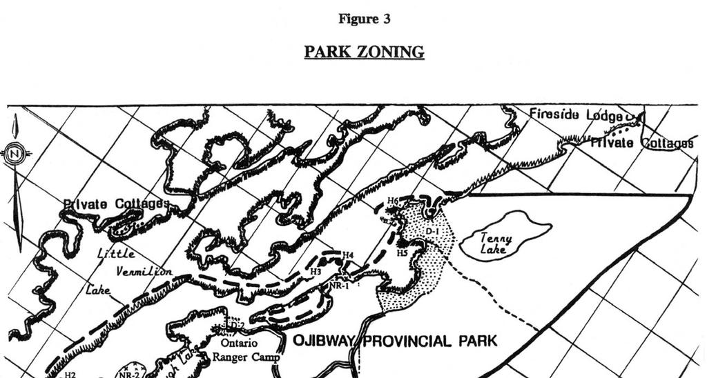
12 4.4 Tourism To provide opportunities for Ontario residents and out-of-province visitors to discover and experience a distinct region of the province. The Park provides day use and camping opportunities for travellers and the local population. Tourism traffic to the Park will serve to provide economic spin-offs. to the community of Sioux Lookout and perhaps to local outfitters (selling ice, minnows, etc.). Greater economic impact can be attained by encouraging visitors to stay in the area longer by providing local attractions. 5.0 PARK BOUNDARY Since Ojibway Provincial Park was designated under the Provincial Parks Act in 1963, two changes have been made to the park boundaries. In October 1970 the Park was reduced by 91.0 hectares as a result of the relocation of Highway 72. In January 1971 the boundary was extended by 122 metres into Little Vermilion Lake, increasing the area by hectares. The Park now encompasses an area of 2,630 hectares of Crown land. With the exception of a few parcels of patented land, the area surrounding the Park is also Crown land. The parcels of patented land are four tourist establishments located close to the Park, and several private cottages at the east and west ends of Little Vermilion Lake (Figure 2). 6.0 ZONING The lands and waters within Ojibway Provincial Park have been zoned for the purposes of recognition and protection, so that they may be allocated to their most appropriate use. (Figure 3). Acceptable land use activities and types of development are specified by zone classifications. 6.1 Development Zones (183 ha.) The main development zone of the Park is found on the south shore of Little Vermilion Lake. This zone (Figure 3, D-1, 163 ha.) includes all facilities and improvements to the Park area, such as buildings, campgrounds, roads, days use area and parking lots. A second development zone (Figure 3, D-2, 20 ha.) includes the Ontario Ranger Camp which is located on the northeast shore of Cedarbough Lake. Generally, areas of established development are a reflection of relatively high development capability. Any additional development will be restricted to the existing development zones in order to reduce impact on the remainder of the Park. 6.2 Nature Reserve Zones (20 ha.) The nature reserve zones include those significant earth and life science features in the Park which require management distinct from adjacent areas NR-1, Wild Rice Stand (8 ha.) The inlet known as Chicago Bay on the south side of Little Vermilion Lake contains a natural wild rice stand NR-2, White Pine Stand (10 ha.) This is a unique stand of White Pine on the north side of Cedarbough Lake. The mature trees are approximately 120 years old with basal diameters of up to one metre and heights of 30 to 40 metres. Within Ontario it is established at the most northerly limit for this tree species range. 6
13 6.2.3 NR-3, Heron Rookery (2 ha.) At the west end of Cedarbough Lake along the north shore and some 400 metres inland an active heron rookery exists. There are approximately fifteen (15) established nests, of which at least ten (10) are definitely active. The Management Guidelines for the Protection of Heronries in Ontario will be applied by maintaining a buffer around this zone. Development in the nature reserve zones will be limited. Trails, necessary signs, minimal interpretive facilities, and temporary facilities for research and management may be permitted, dependent on the sensitivity of the feature. 6.3 Natural Environment Zone (2,377 ha.) The natural environment zone (Figure 3) serves to provide site protection for the representative landscape units in the park. This zone encompasses somewhat rugged, back-country landscapes and constitutes the majority of the park area. It affords protection to significant park values which may not be notable enough to warrant protection in a nature reserve zone. Classification of a natural environment zone also serves to delineate the land area to be utilized in the development of high quality, low intensity recreational opportunities. Development in this zone will be limited to back-country camping, hiking trails and route signs where required. 6.4 Access Zones (30 ha.) Access zones serve as staging areas where minimum facilities support use of the natural environment and historical zones. There are three (3) access zones designated in the park (Figure 3). They are the main Park entrance area (Access Zone 1), the Cedarbough Ontario Ranger Camp access area (Access Zone 2), and the old main park entrance area (Access Zone 3) which is used in the winter by the Ojibway Power Toboggan Association. Development in these access zones will be limited to roads, visitor control structures, basic day use facilities, as well as orientation, interpretive, educational and management facilities. 6.5 Historical Zone (20 ha.) There are six (6) historical zones designated in the Park (Figure 3, H-i to H-6) which incorporate areas of archaeological significance related to the settlement of the area. Archaeological investigations will be conducted in any previously undisturbed ground areas to be developed for park facilities, such as the moose viewing area. These sites represent the Laurel, Selkirk, Woodland, Archaic and Blackduck cultural occupations. From these sites a variety of artifacts, including flakes, lithics, tools and ceramics, have been collected and documented. Resource management priorities in these historical zones will include protection and research. The provision of heritage appreciation opportunities will be a secondary consideration. Development in the historical zones will be limited to interpretive, educational and research management facilities. No permanent access will be created. 7.0 RESOURCE MANAGEMENT The Park will be managed according to the planning and management policies for Natural Environment Class Provincial Parks and in accordance with the following guidelines: 7
14 1) management of the Park will be directed towards the maintenance of the natural landscape, and specific management direction will be determined by park zone prescriptions; and, 2) although policies are discussed individually it is recognized that the different resource components are interrelated and that an integrated approach will be required in order for the Park to achieve its objectives. 7.1 Land Management Natural environment and nature reserve zones have been established to provide protection for earth and life science features of the Park. Refuse and sewage generated by park users will continue to be disposed of outside the Park through certified local facilities. Mineral exploration and mining are not permitted within Provincial Parks. The present gravel pit which is located within the Ontario Ranger camp development zone will be managed in accordance with a Park Aggregate Resource Management Plan. Any further aggregate requirements for in-park purposes will be imported from sources outside Ojibway Provincial Park. 7.2 Vegetation Management The management of vegetation will be directed towards promoting a healthy and natural diversity of vegetation in Ojibway Provincial Park through a Vegetation Management Plan. Specifically, this plan will reduce the impact of spruce budworm damage, creating a safer, more aesthetic park for the public. Copies of this vegetation plan are available under separate cover, from the Ministry of Natural Resources office in Sioux Lookout. Commercial forestry operations will not be permitted within the Park. 7.3 Fisheries Management Sport fishing will be encouraged as a recreation activity for Park visitors. Fishery resources of the Park will continue to be managed in accordance with policies and regulations prevailing in this area. In addition, all fisheries management activities within the Park will adhere to applicable guidelines specified in the Sioux Lookout District Fisheries Management Plan. The Sioux Lookout District Fisheries Management Plan, , Section Provision of Quality Sport Fishing Opportunities, Issue 6, page 18, deals specifically with Little Vermilion Lake. To ensure a sustainable fishery, the lake trout catch and possession limit has been dropped from three to two, and the muskellunge catch limit dropped to one per day, with a possession limit of two. The muskellunge minimum size limit has also been increased from 86 cm to 102 cm. Other tactics also being considered for implementation at a future date are altering the season for game fish and instituting some management techniques for smallmouth bass. 7.4 Wildlife Management The management of wildlife in the Park will be directed towards promoting healthy and diverse populations. Wildlife viewing will be encouraged and enhanced with the further development of hiking and canoeing opportunities. Hunting and trapping will not be permitted. Nuisance animals may be controlled when necessary to protect human health and safety or the health of species outside the Park. When necessary, animal control 8
15 measures will be carried out by Ministry of Natural Resources staff. 7.5 Water Resource Management To ensure the provision of safe, good water quality for park visitors, drinking water and water in the swimming area will be monitored by Ministry of Natural Resources staff on a regular basis to maintain Ontario Ministry of the Environment drinking water standards and Ontario Ministry of Health water quality for bathing beach standards. 8.0 OPERATIONS POLICIES A Park Operations Plan will be prepared to provide park staff with the necessary information required to operate the park on a day-to-day basis. In addition to addressing the operation policies which follow, the strategy will include such topics as budget, staffing, maintenance schedules, enforcement and emergency services. The provisions of the strategy will be consistent with the approved Ontario Provincial Park Operating Standards, and will be reviewed annually and updated as required. Contracting with the private sector to provide services and operate concessions will be encouraged subject to current government and ministry supply policy. These could include canoe rentals, fire wood delivery or other service contracts such as housekeeping, garbage collection, road maintenance and grass cutting. 8.1 Visitor Services The Visitor Services program at Ojibway Provincial Park will follow the direction established in the Regional Visitor Services Plan. The program will offer a high-quality self-use level of service. It will aid visitors in recognizing, using and enjoying the recreational resources of the Provincial Parks system and Ojibway Provincial Park. The Visitor Services program will be developed through the following three components; information, interpretation and recreation Information The Ojibway Provincial Park leaflet will be periodically reviewed and upgraded to accurately reflect the resources and recreational opportunities offered in the Park. Information about the surrounding area natural heritage, facilities and events will also be communicated to park visitors by staff through publications and by park signs. Efforts will be made to gain cooperation from local organizations by providing updated information on the park facilities and events outside of the Park Interpretation The interpretive program at Ojibway Provincial Park will be basic in accordance with Visitor Services Planning and Program Guidelines. Interpretive trails with trail guides and/or sign posts, and a visual display at the entrance gate will form the main components of the interpretive program. The significant earth and life science features which are exhibited in the Park will be highlighted in published pamphlets. The park interpretive program will convey the park story through a variety of themes: Natural History and Ecology: - the significant earth and life science features which are exhibited in the Park, including the white pine stand, wild rice stand and the mosaic of differing communities and ecosystems; and, - the geology of the Wabigoon Belt of the Canadian Shield and its distinctive geological features. 9
16 History of Man in the Park Environments: - prehistory of human habitation in the area especially the Laurel and Blackduck peoples as pertaining to their archaeological representation in the Park area (Figure 3, Historical Zones H-1 to H-6). - early logging and forest industry communities theme; and, - present native use of the land and natural resources of the area Recreation Park visitors will be informed of the opportunities for recreational activities offered both in the Park and in the local area. Recreational information will continue to be displayed within the gatehouse. To complement the use of a trail system, maps will be developed to provide information on minimum impact camping practices to enhance visitors use and enjoyment of the Park. Interpretive programs will promote hiking, fishing, and boating, as well as the appreciation of natural features (e.g. flora, red pine stands, etc.). Self-use approaches, including brochures, signed trails and display panels, will be encouraged. 8.2 Marketing In keeping with the Northwestern Region Marketing Plan an individual marketing plan will be prepared for Ojibway Provincial Park. This plan will be reviewed annually and revised as required. The marketing plan will indicate how to make the public aware of what the Park has to offer in terms of facilities and the type of outdoor recreational opportunities. One objective is to identify additional recreational user groups by emphasizing the opportunities afforded by the park environment and the facilities and activities located there. The hosting of special family days in the Park for the tourists and residents of Sioux Lookout would further promote park use. A major thrust of the marketing plan will be cooperation with area tourist establishments and local organizations. This is aimed at encouraging both park users and other tourists to stay in the area longer by informing them of recreation and tourist opportunities available within the local area. 8.3 Research Research which contributes to the knowledge of the natural and cultural values and recreation management of the Park will be encouraged. All research will require approval by the Ministry of Natural Resources. Appropriate research topics may include earth and life science studies, and site planning for future development such as trail location, wildlife viewing area, and further investigation of archaeological sites in the Park. Regeneration within the developed area of the Park will be monitored to determine the success of the Vegetation Management Strategy. 9.0 PROPOSED DEVELOPMENT Figure 4A depicts the location of proposed and existing park facilities. Figure 4B maps the Cedarbough Ontario Ranger Camp in some detail. The location, design and materials of all facilities constructed within the Park will, as fully as possible, reflect the character of the Park. All development will be carried out in accordance with approved site and development plans applicable to a Natural Environment Class Park. 10
17 11
18 12
19 New facilities will be developed through work program planning or special funding initiatives. All facilities will be managed in accordance with the Park Operating Plan. 9.1 Campground A Campground Redevelopment Plan will be prepared which will specify improvements to existing campground facilities and guide construction of future developments according to Natural Environment Class Park Standards. Contingent upon funding and the development of specific site plans, the following improvements will be undertaken. Many of the campsites require reconstruction and regeneration. These campsites will be relevelled with parking areas upgraded. Vegetation will be managed according to the Vegetation Management Strategy. Nine (9) sites in Area A will be upgraded to provide electrical service. These campsites -will also be relevelled with parking areas upgraded. (Figure 4A) 9.2 Day Use Facilities Existing trails within the Park will be upgraded with new signs and interpretive information. Due to their deteriorated state, upgrading of the existing change houses will be carried out as soon as possible. 9.3 Trail Development Strategy A Trail Development Strategy will be prepared to guide any future development within the natural environment zone, or within the nature reserve zones incorporating site planning with resource protection, recreation management and resource interpretation components. 9.4 Other Facilities Proposals for new facilities have been considered and are among the priorities for construction. These include a waterfowl and moose viewing area near the wild rice stands on Little Vermilion Lake. The possibility of any new facilities will be subject to further study and public review as part of the planning process PLAN IMPLEMENTATION PRIORITIES Implementation of this Management Plan will involve resource management operations and site planning, visitor services and facility development. Implementation of this plan is contingent upon funding approval through work planning and other funding sources Implementation Plan Implementation of this Management Plan will involve the preparation of operating, trail development, vegetation management and marketing plans. All day to day park activities will be guided by a park operating strategy which will be updated when the management plan is approved. Implementation will be dependent on funding through work planning and other funding sources Park Development Priorities Priorities for development of park facilities have been determined through an examination of the following: existing and future program needs; present and projected levels of visitation; and the structural condition of present park facilities. Proposed projects are listed below in order of priority. 13
20 - Implementation of the Vegetation Management Plan within the development zone. - Campground upgrading: - additional nine (9) sites electrified; and, - campsite redevelopment and rehabilitation - Change-house upgrading. - Develop new trail to waterfowl and moose viewing area PUBLIC CONSULTATION The Ministry of Natural Resources is committed to a policy of public consultation. The scope of public involvement in a management plan will vary directly with the significance of the park resources and the level of concern and interest in the planning issues related to the Park. Public consultation during this management planning process has involved the following components: 1. The Ojibway Provincial Park Background Information document and the Preliminary Park Management Plan, were made available for public review and comment. Advertisements in the Sioux Lookout Explorer and Dryden Observer newspapers notified the public of plan availability and review period. 2. Copies of both documents were placed in the Sioux Lookout Public Library. Original documents were available in the Sioux Lookout District Office. Additional copies were placed at Ministry of Natural Resources offices in Ignace, Dryden, Fort Frances, Red Lake and Kenora. 3. Direct mailing also occurred at the beginning of each phase of the planning process. Documents were sent to the following: neighbouring land owners; the Municipality of Sioux Lookout; other government agencies such as the Ministry of the Environment; provincial and federal members of parliament; environmental and recreation-oriented interest groups; the Local Services Board; and interested members of the public. 4. A questionnaire was distributed at Ojibway Park during the period June 1990 to the end of August The questionnaire was designed to evoke park user response for input to the park plan; and, 5. All public input was analyzed and incorporated into the final draft of the Ojibway Provincial Park Management Plan. This correspondence was received during the public review period of the Background Information document and the Preliminary Management Plan. The following is our response to public concerns. 1) The Ministry of Northern Development and Mines responded to supporting multiple resource use in the natural environment zones within the park. In keeping with the legislation for Provincial Parks in Ontario, activities such as timber harvesting, mining, trapping and commercial fishing are excluded from parks. 2) The majority of internal and public response supported the reclassification of the Park. However, two respondants who advocated multiple resource use in parks felt that Ojibway should remain a Recreation Park. The initial classification of Ojibway as a Recreation Park occurred at its creation in The draft West Patricia Land Use Plan (1982) recommended the change to Natural Environment classification. Recreation Parks are areas which support a 14
21 wide variety of outdoor recreation opportunities for large numbers of people in relatively small, attractive surroundings. Natural Environment Parks incorporate natural, cultural and recreational features, all located in larger areas of over 2,000 hectares is size. Resource extraction would be excluded regardless of the park classification. This change to Natural Environment more accurately reflects the zoning of this park. It does not change the management of Ojibway Provincial Park. 3) Concerned about the method that the Ministry of Natural Resources will use to treat budworm. The Vegetation Management Strategy addresses the budworm problem. It proposes realistic changes that can be made at a reasonable financial cost and will be conducted in a manner which will minimize the visual and acoustical impacts upon park visitors. 4) The need for additional electrical sites, approximately nine in Area 5 of the park, was identified in the Background Information and in the questionnaire distributed to park users during the summer of Additional sites will be developed, contingent on funding and the preparation and approval of development and site plans (Figure 4A) in accordance with provincial standards for Natural Environmental Parks. 5) Cedarbough Ontario Ranger Camp should continue its role as an educational facility in the Park. The goal of the Ontario Ranger Program is to provide the Ontario Rangers with working experiences and educational instruction to improve their understanding and appreciation of integrated resource management so that they may provide useful support to Ministry work programs, and have the opportunities for career progression within the Ministry of Natural Resources. Participation by the Ontario Rangers will enhance the interpretive role of the park s natural features. The Ontario Rangers will continue assisting in the park s maintenance program which will enhance the educational and learning aspects associated with the natural features of the area. They will also learn, through participation in the Ontario Ranger Program, the Provincial Park goals and objectives. 6) The Federation of Ontario Naturalists requested that a larger area be designated as Nature Reserve Zone in proximity to the heron rookery. The Management Guidelines for the Protection of Heronries in Ontario are being applied to the heron rookery. The zone beyond the 2 hectare Nature Reserve is a Natural Environment Zone. There is no plan for development, such as trails, in the 1 km. zone adjacent to the rookery. 7) A local interest group requested that snowmobiling be given separate consideration from other sports associated within the park and asked that utilization of the Hudson - Sioux Lookout snowmobile loop be allowed during the winter months. At the same time, one interest group requested that snowmobiling be discouraged in the Park. Through public response to the Background Information document, the Ojibway Power Toboggan Association of Sioux Lookout identified the use of the old park access road and the connecting roadway to the east boat launching ramp as a snowmobile trail during the winter season. This section of the trail within the Park is part of their Hudson-Sioux Lookout loop. The only designated trail will include the Snowmobile Access Zone shown on Figure 3. 15
22 8) Major support was received for the development of a trail and viewing area in the vicinity of the wild rice stand on Little Vermilion Lake. The trail will be designed as per Provincial Park Development Standards to protect any significant earth and life science features. Details, such as timing of construction to minimize disruption, will be outlined in a plan prior to construction of this trail PLAN REVIEW AND AMENDMENT This Ojibway Provincial Park Management Plan will be reviewed as warranted during its 20 year time frame. As a minimum requirement, the plan will be reviewed ten years after approval. Review of this plan may become necessary from time to time to ensure its continuing relevance. This need may arise in the face of changing circumstances where park objectives and management policies are no longer appropriate. It may also be necessitated by a proposal which represents a significant departure from the original direction and intent of the plan, or in the event that during its term the plan is rendered obsolete. Revisions to the approved Park Management Plan, whether as the result of a scheduled or unscheduled review, may require: - a re-evaluation of the original background information and issues used in the original planning program; - a determination as to the scope of the review which could range from concluding that the provisions of the original plan were still appropriate to application of the entire park management process if it was felt that the plan had major shortcomings in light of current knowledge. - provision of a formal opportunity for public involvement in the review, which could range from an Invitation to Participate and notification of results, to the application of the complete park planning process; and, - production of the Park Management Plan Review document or a new Management Plan. 16
23 13.0 REFERENCES Beaudry, M., Lavender, A., and Sexsmith, J.L A History of Selected Parks of Northwestern Ontario. Ministry of Natural Resources, Northwestern Region, Kenora. Bowman, I., and Siderius, J Management Guidelines for the Protection of Heronries in Ontario. Ministry of Natural Resources, Wildlife Branch, Toronto. Goddard, W.A Life Science Inventory of Ojibway Provincial Park Environmental Planning Series Ministry of Natural Resources, Northwestern Region, Kenora. Lambert, P.J.B Archaeological Survey of Ontario Provincial Parks in the Kenora Region and Assessment of Archaeological Resources in Adjacent Geographic Areas. Ministry of Natural Resources, Northwestern Region, Kenora. Ministry of Natural Resources Ontario Provincial Parks Statistics. Ministry of Natural Resources, Provincial Parks and Natural Heritage Policy Branch, Queen s Park, Toronto. Ministry of Natural Resources Sioux Lookout District Fisheries Management Plan Ministry of Natural Resources, Sioux Lookout District. Ministry of Natural Resources Ontario Provincial Parks: Planning and Management Policies. Provincial Parks Branch, Toronto. Ministry of Natural Resources Ojibway Provincial Parks Interim Management Statement. Ministry of Natural Resources, Sioux Lookout District. Nobel, T Life Science Inventory Check Sheet for Ojibway Provincial Park - Wild Rice Marsh. Pine. Unpublished. Roed, M.A Northern Ontario Engineering Geology Terrain Study 22. Wabigoon Lake Area (N.T.S. 52F/NE) District of Kenora; Ontario Geological Survey. Rowe, J.S Forest Regions of Canada. Canada Department of the Environment, Canadian Forestry Service. Seim, G Geological Overview of the Area Within Ojibway Provincial Park. Unpublished. 17
24 Ministry of Natural Resources Ojibway Provincial Park Background Information. Ministry of Natural Resources, Sioux Lookout District. Ministry of Natural Resources Ojibway Provincial Park Preliminary Management Plan. Ministry of Natural Resources, Sioux Lookout District. 18
Ouimet Canyon Provincial Nature Reserve. Management Plan
 Ouimet Canyon Provincial Nature Reserve Management Plan NOTE: This document has been scanned and formatted, and therefore is slightly different from the original version. -March 2002 Additional copies
Nakina Moraine Provincial Park. Interim Management Statement. Ontario. Ministry of Natural Resources
 Nakina Moraine Provincial Park Interim Management Statement Ontario Ministry of Natural Resources 1999, Queen's Printer for Ontario Printed in Ontario, Canada Additional copies of this publication can
Watchorn Provincial Park. Management Plan
 Watchorn Provincial Park Management Plan 2 Watchorn Provincial Park Table of Contents 1. Introduction... 3 2. Park History... 3 3. Park Attributes... 3 3.1 Natural... 4 3.2 Recreational... 4 3.3 Additional
Beaver Creek Provincial Park. Management Plan
 Beaver Creek Provincial Park Management Plan 2 Beaver Creek Provincial Park Table of Contents 1. Introduction... 3 2. Park History... 3 3. Park Attributes... 4 3.1 Natural... 4 3.2 Recreational... 4 4.
Approval Statement. Brian Pfrimmer, Central Zone Manager Ontario Parks
 Approval Statement I am pleased to approve this Interim Management Statement for Dividing Lake Provincial Nature Reserve. This Nature Reserve contains biological features of provincial significance and
Clearwater Lake Provincial Park. Draft Management Plan
 Clearwater Lake Provincial Park Draft Management Plan Clearwater Lake Provincial Park Draft Management Plan Table of Contents 1. Introduction... 3 2. Park History... 4 3. Park Attributes... 4 3.1 Location/Access...4
NOV UPPER MADAWASKA RIVER PROVINCIAL PARK INTERIM MANAGEMENT STATEMENT. Ontario
 NOV 1 3 2001 UPPER MADAWASKA RIVER PROVINCIAL PARK INTERIM MANAGEMENT STATEMENT Ontario . BACKGROUND INFORMATION NAME: Upper Madawaska River REGIONAL SETTING MAP PROPOSED CLASS: U.N.R. DISTRICT: U.N.R.
Ontario. Tide Lake Provincial Nature Reserve. Interim Management Statement. Ministry of Natural Resources
 Ontario Tide Lake Provincial Nature Reserve nterim Management Statement Ministry of Natural Resources Tide Lake Provincial Nature Reserve nterim Management Statement Ontario Ministry of Natural Resources
Sand Lakes Provincial Park. Draft Management Plan
 Sand Lakes Provincial Park Draft Management Plan 2 Sand Lakes Provincial Park Table of Contents 1. Introduction... 3 2. Background... 3 3. Park Purpose... 5 4. Park Management Guidelines... 6 Appendix...
Wallace Lake Provincial Park. Management Plan
 Wallace Lake Provincial Park Management Plan 2 Wallace Lake Provincial Park Table of Contents 1. Introduction... 3 2. Park History... 3 3. Park Attributes... 4 3.1 Natural... 4 3.2 Recreational... 4 4.
MANAGEMENT DIRECTION STATEMENT June, 1999
 Thompson River District MANAGEMENT DIRECTION STATEMENT June, 1999 for Roche Lake Provincial Park Ministry of Environment Lands and Parks BC Parks Division Table of Contents I. Introduction A. Setting
ISBN c 1988 Government of Ontario Printed in Ontario, Canada
 Single copies of this publication are available for $2.00 from the Ontario Ministry of Natural Resources, Espanola District Office, P.O. Box 1340, 148 Fleming Street, Espanola, Ontario, POP 1CO, telephone:
Dividing Lake Provincial Nature Reserve
 - Do Not Remove i, '" i ' Dividing Lake Provincial Nature Reserve I!.' Interim Management Statement Amendment 2001-001 Park Boundary Amendment Approved: r.in'r entral Zone, Ontario Parks PJ Date 2. ()/
Numaykoos Lake Provincial Park. Management Plan
 Numaykoos Lake Provincial Park Management Plan 2 Numaykoos Lake Provincial Park Table of Contents 1. Introduction... 3 2. Background... 3 3. Park Purpose... 5 4. Park Management Guidelines... 6 Appendix...
Rocky Lake Provincial Park. Draft Management Plan
 Rocky Lake Provincial Park Draft Management Plan Rocky Lake Provincial Park Draft Management Plan Table of Contents 1. Introduction... 3 2. Park History... 3 3. Park Attributes... 4 3.1 Location/Access...4
Criddle/Vane Homestead Provincial Park. Management Plan
 Criddle/Vane Homestead Provincial Park Management Plan 2 Criddle/Vane Homestead Provincial Park Table of Contents 1. Introduction... 3 2. Park History.... 3 3. Park Attributes.... 4 3.1 Natural.... 4 3.2
Sasagiu Rapids Provincial Park. Draft Management Plan
 Sasagiu Rapids Provincial Park Draft Management Plan 2 Sasagiu Rapids Provincial Park Table of Contents 1. Introduction... 3 2. Background and Park Attributes... 3 2.1 Park History.... 3 2.2 Natural Features...
Marchand Provincial Park. Management Plan
 Marchand Provincial Park Management Plan 2 Marchand Provincial Park Table of Contents 1. Introduction... 3 2. Park History... 3 3. Park Attributes... 4 3.1 Natural... 4 3.2 Recreational... 4 3.3 Additional
Steel River Provincial Park. Interim Management Statement. Ministry of Natural Resources. Ontario. Ministry of Natural Resources.
 Steel River Provincial Park Interim Management Statement Ontario Ministry of Natural Resources (j) Ontario Ministry of Natural Resources Additional copies of this publication are obtainable only from:
Port Bruce. Interim Management Statement
 Port Bruce Interim Management Statement Port Bruce Interim Management Statement August 3, 1999 This Port Bruce Provincial Park Interim Management Statement provides direction for the custodial management
5.0 OUTDOOR RECREATION OPPORTUNITIES AND MANAGEMENT
 5.0 OUTDOOR RECREATION OPPORTUNITIES AND MANAGEMENT 5.1 Introduction This section describes the range of recreational activities that currently take place in Marble Range and Edge Hills Parks, as well
A GUIDE TO MANITOBA PROTECTED AREAS & LANDS PROTECTION
 A GUIDE TO MANITOBA PROTECTED AREAS & LANDS PROTECTION Manitoba Wildands December 2008 Discussions about the establishment of protected lands need to be clear about the definition of protection. We will
KANANASKIS COUNTRY PROVINCIAL RECREATION AREAS MANAGEMENT PLAN DRAFT TERMS OF REFERENCE - November 20, 2007
 KANANASKIS COUNTRY PROVINCIAL RECREATION AREAS MANAGEMENT PLAN DRAFT TERMS OF REFERENCE - November 20, 2007 BACKGROUND There are 42 Provincial Recreation Areas (PRAs) within Kananaskis Country located
Pembina Valley Provincial Park. Draft Management Plan
 Pembina Valley Provincial Park Draft Management Plan 2 Pembina Valley Provincial Park Table of Contents 1. Introduction... 3 2. Park History... 3 3. Park Attributes... 3 3.1 Natural... 3 3.2 Recreational...
Birch Point Provincial Park. Management Plan
 Birch Point Provincial Park Management Plan 2 Birch Point Provincial Park Table of Contents 1. Introduction... 3 2. Park History... 3 3. Park Attributes... 4 3.1 Natural... 4 3.2 Recreational... 4 4. Park
Cavern Lake Provincial Nature Reserve. Management Plan
 Cavern Lake Provincial Nature Reserve Management Plan NOTE: This document has been scanned and formatted, and therefore is slightly different from the original version. - March 2002 Additional copies of
MacMurchy Township End Moraine. Interim Management Statement
 MacMurchy Township End Moraine Interim Management Statement 2006 Approval Statement I am pleased to approve this Interim Management Statement for MacMurchy Township End Moraine Provincial Park (P1591).
PROUDLY BRINGING YOU CANADA AT ITS BEST. Management Planning Program NEWSLETTER #1 OCTOBER, 2000
 PROUDLY BRINGING YOU CANADA AT ITS BEST VUNTUT NATIONAL PARK Management Planning Program NEWSLETTER #1 OCTOBER, 2000 INTRODUCTION This newsletter launches the development of the first management plan for
We are pleased to approve the Craigleith Provincial Park Management Plan, as official policy for the management and development of this park.
 We are pleased to approve the Craigleith Provincial Park Management Plan, as official policy for the management and development of this park. The plan reflects this Ministry s intent to protect natural
Continental Divide National Scenic Trail Legislative History and Planning Guidance
 Continental Divide National Scenic Trail Legislative History and Planning Guidance Legislation, Policy, and Direction Regarding National Scenic Trails The National Trails System Act, P.L. 90-543, was passed
Criddle/Vane Homestead Provincial Park. Draft Management Plan
 Criddle/Vane Homestead Provincial Park Draft Management Plan 2 Criddle/Vane Homestead Provincial Park Table of Contents 1. Introduction... 3 2. Park History.... 3 3. Park Attributes.... 3 3.1 Natural....
Wallace Lake Provincial Park. Draft Management Plan
 Wallace Lake Provincial Park Draft Management Plan Wallace Lake Provincial Park Draft Management Plan Table of Contents 1. Introduction... 3 2. Park History... 3 3. Park Attributes... 4 3.1 Natural...
OMINEACA PROVINCIAL PARK
 OMINEACA PROVINCIAL PARK AND PROTECTED AREA PURPOSE STATEMENT AND ZONING PLAN March 2003 OMINECA PROVINCIAL PARK AND PROTECTED AREA Purpose Statement and Zoning Plan Omineca Park and Omineca Protected
Norris Lake Provincial Park. Draft Management Plan
 Norris Lake Provincial Park Draft Management Plan 2 Norris Lake Provincial Park Table of Contents 1. Introduction... 3 2. Park History... 3 3. Park Attributes... 4 3.1 Natural... 4 3.2 Recreational...
Lion s Head. Interim Management Statement
 Lion s Head Interim Management Statement Lion's Head Provincial Nature Reserve Interim Management Statement July 14, 1997 APPROVAL STATEMENT This Interim Management Statement will provide interim direction
Yard Creek Provincial Park. Management Plan
 Yard Creek Provincial Park Management Plan Draft January 2010 Yard Creek Provincial Park Management Plan Approved by: telàlsemkin/siyam/chief Scott Benton Bill Williams Squamish Executive Director ation
Establishing a National Urban Park in the Rouge Valley
 STAFF REPORT ACTION REQUIRED Establishing a National Urban Park in the Rouge Valley Date: March 29, 2012 To: From: Wards: Reference Number: Executive Committee Deputy City Manager, Cluster B All p:\2012\cluster
Appendix A BC Provincial Parks System Goals
 Appendix A BC Provincial Parks System Goals The British Columbia Provincial Parks System has two mandates: To conserve significant and representative natural and cultural resources To provide a wide variety
 March 25, 1994 To: Re: MEMO TO FILE MINOR AMENDMENT - PINERY PROVINCIAL PARK MANAGEMENT PLAN The following paragraph from page 5 of the Pinery Provincial Park Management Plan (ISBN 0-7729-0290-9) lnsects
MANAGEMENT DIRECTION STATEMENT June, 1999
 Thompson River District MANAGEMENT DIRECTION STATEMENT June, 1999 for Clearwater River Corridor (Addition to Wells Gray Park) Ministry of Environment Lands and Parks BC Parks Division ii Table of Contents
Ontario s Approach to Wilderness: A Policy May 1997 (Version 1.0)
") Ontario s Approach to Wilderness: A Policy May 1997 (Version 1.0) 1.0. Introduction Wilderness is important to Ontarians, important to the sustained, healthy functioning of Ontario s ecosystems. The Ministry
Ontario s Approach to Wilderness: A Policy May 1997 (Version 1.0) 1.0. Introduction Wilderness is important to Ontarians, important to the sustained, healthy functioning of Ontario s ecosystems. The Ministry
South Atikaki Provincial Park. Draft Management Plan
 South Atikaki Provincial Park Draft Management Plan South Atikaki Provincial Park Draft Management Plan Table of Contents 1. Introduction... 3 2. Park History... 3 3. Park Attributes... 3 3.1 Natural...
Oxtongue River- Ragged Falls Provincial Park. Management Plan
 Oxtongue River- Ragged Falls Provincial Park Management Plan 4279 0-7729-4782-1 1990, Queens Printer for Ontario Printed in Ontario, Canada Limited copies of this publication are obtainable from: Ministry
Trappist Monastery Provincial Park. Management Plan
 Trappist Monastery Provincial Park Management Plan 2 Trappist Monastery Provincial Park Table of Contents 1. Introduction... 3 2. Park History... 3 3. Park Attributes... 4 3.1 Natural... 4 3.2 Recreational...
Whitemouth Falls Provincial Park. Draft Management Plan
 Whitemouth Falls Provincial Park Draft Management Plan Whitemouth Falls Provincial Park Draft Management Plan Table of Contents 1. Introduction... 3 2. Park History... 3 3. Park Attributes... 4 3.1 Natural...
Bayview Escarpment. Interim Management Statement
 Bayview Escarpment Interim Management Statement Bayview Escarpment Provincial Nature Reserve Interim Management Statement January 15, 1995 REGIONAL DIRECTOR'S APPROVAL STATEMENT This Interim Management
TOURISM & PUBLIC SERVICES RURAL SIGNAGE POLICY
 Policy and Procedures Subject Title: Tourism and Public Services Rural Signage Policy Corporate Policy (Approved by Council): X Policy Ref. No.: ROADS-01-07 Administrative Policy (Approved by CAO): By-Law
MARBLE RIVER PROVINCIAL PARK
 MARBLE RIVER PROVINCIAL PARK PURPOSE STATEMENT AND ZONING PLAN March 2003 MARBLE RIVER PROVINCIAL PARK Purpose Statement and Zoning Plan Primary Role The primary role of Marble River Park is to protect
Little Limestone Lake Provincial Park. Draft Management Plan
 Little Limestone Lake Provincial Park Draft Management Plan Little Limestone Lake Provincial Park Draft Management Plan Table of Contents 1. Introduction... 3 2. Background... 3 3. Planning context...
As outlined in the Tatshenshini-Alsek Park Management Agreement, park management will:
 Management Strategy General Strategy The priority management focus for the park is to ensure that its internationally significant natural, cultural heritage and recreational values are protected and that
Samuel de Champlain Provincial Park Management Plan
 Samuel de Champlain Provincial Park Management Plan Ontario Ministry of Natural Resources Cover Photo: Tracking the Rapids c. 1891 (detail) Francis Anne Hopkins (1838-1919) Sigmund Samuel Collection, Royal
2.1 Physical and Biological Description Matabitchuan River Watershed
 2.1 Physical and Biological Description Watershed 2.1.1 Physical Description The system watershed has a total area of about 933 km 2 and is a tributary system to Lake Temiskaming and the Ottawa River Drainage
Pillar Park. Management Plan
 Pillar Park Management Plan January 2014 Pillar Park Management Plan Approved by: Jeff Leahy Regional Director Thompson Cariboo Region BC Parks January 9, 2014 Date Brian Bawtinheimer Executive Director
Policy PL Date Issued February 10, 2014
 Subject RENEWABLE ENERGY ON CROWN LAND Compiled by Renewable Energy Program, Biodiversity Branch Replaces Policy Directives Waterpower Site Release Crown Land Onshore Windpower Development - Crown Land
PROPOSAL FOR RECLASSIFICATION, BOUNDARY AMENDMENT AND DRAFT CONCEPT PLAN FOR SASKATOON MOUNTAIN NATURAL AREA. Frequently Asked Questions
 PROPOSAL FOR RECLASSIFICATION, BOUNDARY AMENDMENT AND DRAFT CONCEPT PLAN FOR SASKATOON MOUNTAIN NATURAL AREA 1. Why is this proposal being put forward? Frequently Asked Questions For many years, Alberta
White Lake Peatlands. Interim Management Statement
 White Lake Peatlands Interim Management Statement 2007 APPROVAL STATEMENT I am pleased to approve this Interim Management Statement for White Lake Peatlands Provincial Park. This park was regulated under
Boyne Valley Provincial Park. Interim Management Statement
 Boyne Valley Provincial Park Interim Management Statement January 20, 1995 REGIONAL DIRECTOR'S APPROVAL STATEMENT This Interim Management Statement will provide interim direction for the management of
BACKCOUNTRY TRAIL FLOOD REHABILITATION PROGRAM
 BACKCOUNTRY TRAIL FLOOD REHABILITATION PROGRAM Backcountry Trail Flood Rehabilitation A June 2013 Flood Recovery Program Summary In June 2013, parts of Southern Alberta were devastated from significant
ANAGEMENT. LAN November, 1996
 M ANAGEMENT P LAN November, 1996 for Paul Lake Provincial Park Ministry of Environment, Lands and Parks BC Parks Department Paul Lake Provincial Park M ANAGEMENT P LAN Prepared by BC Parks Kamloops Area
Mackinnon Esker Ecological Reserve Draft - Management Plan
 Mackinnon Esker Ecological Reserve Draft - Management Plan May 2011 Photo Credit: This document replaces the direction provided in the Carp Lake Provincial Park and Protected Area and Mackinnon Esker Ecological
April 10, Mark Stiles San Juan Public Lands Center Manager 15 Burnett Court Durango, CO Dear Mark,
 Mark Stiles San Juan Public Lands Center Manager 15 Burnett Court Durango, CO 81301 Dear Mark, We are pleased to offer the following comments on the draft San Juan Public Lands Center management plans
2.0 PARK VISION AND ROLES
 2.0 PARK VISION AND ROLES 2.1 Significance in the Protected Area System Marble Range and Edge Hills provincial parks protect 6.8% of the Pavillion Ranges Ecosection, which is located in the Southern Interior
NECHAKO CANYON PROTECTED AREA
 NECHAKO CANYON PROTECTED AREA PURPOSE STATEMENT AND ZONING PLAN March 2003 1 Nechako Canyon Protected Area Purpose Statement and Zoning Plan The Nechako Canyon Protected Area (1,246 hectares) is located
Longlac North Conservation Reserve (C2207) Statement of Conservation Interest
 Statement of Conservation Interest") Longlac North Conservation Reserve (C2207) Statement of Conservation Interest April 2003 Prepared for the Ontario Ministry of Natural Resources, Northwest Region by Rebecca Zeran and Natalie Kolody OLL
Longlac North Conservation Reserve (C2207) Statement of Conservation Interest April 2003 Prepared for the Ontario Ministry of Natural Resources, Northwest Region by Rebecca Zeran and Natalie Kolody OLL
MAIN LAKE PROVINCIAL PARK
 MAIN LAKE PROVINCIAL PARK PURPOSE STATEMENT AND ZONING PLAN March 2003 MAIN LAKE PROVINCIAL PARK Purpose Statement and Zoning Plan Primary Role The primary role of Main Lake Park is to protect a biologically
Grand Rapids Provincial Park. Draft Management Plan
 Grand Rapids Provincial Park Draft Management Plan Grand Rapids Provincial Park Draft Management Plan Table of Contents 1. Introduction... 3 2. Park History... 3 3. Park Attributes... 4 3.1 Location/Access...4
Decision Memo Broken Wheel Ranch Equestrian Outfitter Special-Use Permit Proposed Action
 Decision Memo Broken Wheel Ranch Equestrian Outfitter Special-Use Permit USDA Forest Service Mississippi Bluffs Ranger District, Shawnee National Forest Jackson and Union Counties, Illinois Proposed Action
Economic Development and Tourism
 SECTION 4 SECTION 4 Economic Development and Tourism 4. Economic Development and Tourism Tourism plays a very important role in Niagara s economy, providing employment and generating business for support
Labrador - Island Transmission Link Target Rare Plant Survey Locations
 27-28- Figure: 36 of 55 29-28- Figure: 37 of 55 29- Figure: 38 of 55 #* Figure: 39 of 55 30- - east side Figure: 40 of 55 31- Figure: 41 of 55 31- Figure: 42 of 55 32- - secondary Figure: 43 of 55 32-
INFORMATION NOTICE 15-2 Limited & Excluded Lands
 INFORMATION NOTICE 15-2 Limited & Excluded Lands Schedule 1 (Land Description) of onshore petroleum Agreements issued by the Department of Energy details the total hectares calculated. Total hectares are
ROBERTS CREEK PROVINCIAL PARK MASTER PLAN. November, 1981
 Ministry of Lands, Parks and Housing Parks and Outdoor Recreation Division Park Operations Branch North Vancouver, B. C. ROBERTS CREEK PROVINCIAL PARK MASTER PLAN November, 1981 Mr. G. Trachuk Director
Michipicoten Island Regional Plan
 Michipicoten Island Regional Plan This is one of twenty Regional Plans that support implementation of the Lake Superior Biodiversity Conservation Strategy (Strategy). The Strategy, prepared and overseen
Daisy Dean Trail 628/619 ATV Trail Construction
 Background and Purpose and Need The Daisy Dean ATV Trail Construction Project is located in the Little Belt Mountains, Musselshell Ranger District, Lewis and Clark National Forest approximately 32 miles
Winnipeg Beach Provincial Park. Draft Management Plan
 Winnipeg Beach Provincial Park Draft Management Plan 2 Winnipeg Beach Provincial Park Table of Contents 1. Introduction... 3 2. Park History... 3 3. Park Attributes... 4 3.1 Natural...4 3.2 Recreational...4
FINGER-TATUK PROVINCIAL PARK
 FINGER-TATUK PROVINCIAL PARK PURPOSE STATEMENT AND ZONING PLAN March 2003 FINGER-TATUK PROVINCIAL PARK Purpose Statement and Zoning Plan Finger-Tatuk Provincial Park is 17,151 ha in size. It includes the
communication tower means a tower or structure built to support equipment used to transmit communication signals;
 Ontario Ministry of Natural Resources Subject Communication Tower Sites on Crown Land Compiled by - Branch Lands & Waters Section Land Management Policy PL 4.10.02 Replaces Directive Title Communication
PURPOSE AND NEED. Introduction
 Public Scoping: Allocation of Recreation Capacity for Commercial Outfitter Guide Services on North Kruzof Island Trails (Kruzof Island Outfitter Guide) PURPOSE AND NEED Introduction The U.S. Department
Pinawa Provincial Park. Draft Management Plan
 Pinawa Provincial Park Draft Management Plan Pinawa Provincial Park Draft Management Plan Table of Contents 1. Introduction... 3 2. Park History... 3 3. Park Attributes... 4 3.1 Natural... 4 3.2 Recreational...
Proposed National Marine Conservation Area Reserve Southern Strait of Georgia PROJECT UPDATE Spring 2012
 Proposed National Marine Conservation Area Reserve Southern Strait of Georgia PROJECT UPDATE Spring 2012 National marine conservation areas (NMCAs) are established to protect, conserve and present examples
Recreation Opportunity Spectrum for River Management v
 Recreation Opportunity Spectrum for Management v. 120803 Introduction The following Recreation Opportunity Spectrum (ROS) characterizations and matrices mirror the presentation in the ROS Primer and Field
Order of the Minister of Environment #39, August 22, 2011 Tbilisi
 Registration Code 360050000.22.023.016080 Order of the Minister of Environment #39, August 22, 2011 Tbilisi On preparatory stages and procedure of the methodology for Elaborating structure, content and
non-resident means an individual who is not a resident; and
 Ontario Ministry of Natural Resources Subject Non-Resident Crown Land Camping Northern Ontario Compiled by - Branch Lands & Waters Replaces Directive Title Same Section Land Management Number Same Policy
PLUMPER COVE MARINE PARK MASTER PLAN
 Lower Mainland Region Park Operations Branch Parks and Outdoor Recreation Division Ministry of Lands, Parks and Housing North Vancouver, B.C. PLUMPER COVE MARINE PARK MASTER PLAN DECEMBER, 1980 PLUMPER
Trappist Monastery Provincial Park. Draft Management Plan
 Trappist Monastery Provincial Park Draft Management Plan 2 Trappist Monastery Provincial Park Table of Contents 1. Introduction... 3 2. Park History... 3 3. Park Attributes... 3 3.1 Natural... 3 3.2 Recreational...
SPECTACLE LAKE PROVINCIAL PARK PURPOSE STATEMENT AND ZONING PLAN
 SPECTACLE LAKE PROVINCIAL PARK PURPOSE STATEMENT AND ZONING PLAN August 2003 1 SPECTACLE LAKE PROVINCIAL PARK Purpose Statement and Zoning Plan Primary Role The primary role of Spectacle Lake Park is to
Hudson Bay Lowlands Proposed Protected Areas
 Hudson Bay Lowlands Proposed Protected Areas Hudson Bay Lowlands Proposed Protected Areas The Protected Areas Initiative has identified portions of the Hudson Bay Lowlands region that have significant
Portage Spillway Provincial Park. Draft Management Plan
 Portage Spillway Provincial Park Draft Management Plan 2 Portage Spillway Provincial Park Table of Contents 1. Introduction... 3 2. Park History... 3 3. Park Attributes... 4 3.1 Natural... 4 3.2 Recreational...
White Mountain National Forest Saco Ranger District
 United States Department of Agriculture Forest Service White Mountain National Forest 33 Kancamagus Highway Conway, NH 03818 Comm: (603) 447-5448 TTY: (603) 447-3121 File Code: 1950 Date: February 26,
Sawtooth National Forest Fairfield Ranger District
 United States Department of Agriculture Forest Service Sawtooth National Forest Fairfield Ranger District P.O. Box 189 Fairfield, ID. 83327 208-764-3202 Fax: 208-764-3211 File Code: 1950/7700 Date: December
Seager Wheeler Lake. Representative Area. -- Concept Management Plan --
 Seager Wheeler Lake Representative Area -- Concept Management Plan -- Saskatchewan Environment and Resource Management January, 1999 Saskatchewan s Representative Areas Network Program The Government of
County of Elgin Tourism Signage Policy Addendum A
 1.0 INTRODUCTION County of Elgin Tourism Signage Policy Addendum A 1.1 PURPOSE OF ELGIN TOURISM SIGNAGE POLICY To define the eligibility, use, design and authority for tourism oriented directional signage
PARK MANAGEMENT PLANNING SERIES STURGEON BAY PROVINCIAL PARK MANAGEMENT PLAN
 PARK MANAGEMENT PLANNING SERIES STURGEON BAY PROVINCIAL PARK MANAGEMENT PLAN MNR 3477 ISBN 0 7729 1018 9 1986 Government of Ontario Limited copies of this publication are obtainable at the Ministry of
Stuart River Provincial Park Purpose Statement and Zoning Plan
 Stuart River Provincial Park Purpose Statement and Zoning Plan Stuart River Provincial Park protects three-quarters of the 110 kilometer long Stuart River corridor between Stuart Lake and the Nechako River.
BLANKET CREEK PROVINCIAL PARK
 BLANKET CREEK PROVINCIAL PARK PURPOSE STATEMENT AND ZONING PLAN February 2003 BLANKET CREEK PROVINCIAL PARK Purpose Statement and Zoning Plan Primary Role The primary role of Blanket Creek Park is to maintain
STONE MOUNTAIN PROVINCIAL PARK Purpose Statement and Zoning Plan
 1 STONE MOUNTAIN PROVINCIAL PARK Purpose Statement and Zoning Plan Stone Mountain Provincial Park is situated 140 km west of Fort Nelson at Kilometre 595 of the Alaska Highway. The 25 690 ha park is located
Noganosh Lake. Interim Management Statement
 Noganosh Interim Management Statement March 1, 2004 The Noganosh Provincial Park Interim Management Statement provides direction for the custodial management of Noganosh Provincial Park until such time
APPENDIX. Alberta Land Stewardship Act AMENDMENTS TO THE SOUTH SASKATCHEWAN REGIONAL PLAN
 APPENDIX Alberta Land Stewardship Act AMENDMENTS TO THE SOUTH SASKATCHEWAN REGIONAL PLAN 1 All references to Alberta Environment and Sustainable Resource Development, Environment and Sustainable Resource
DIRECTOR S ORDER #41: Wilderness Preservation and Management
 These are relevant sections about Wilderness Management Plans from National Park Service 2006 Management Policies, Director s Orders #41 and Reference Manual 41. National Park Service U.S. Department of
PERFORMANCE INDICATORS
 PERFORMANCE INDICATORS for the greenbelt plan Part 1, 2015 Ontario.ca/mah PERFORMANCE INDICATORS for the greenbelt plan Part 1, 2015 TABLE OF CONTENTS Page Welcome to Greenbelt Plan Performance Indicators
ANAGEMENT P LAN. February, for Elk Lakes and Height of the Rockies Provincial Parks. Ministry of Environment, Lands and Parks BC Parks Division
 M ANAGEMENT P LAN February, 1999 for Elk Lakes and Height of the Rockies Provincial Parks Ministry of Environment, Lands and Parks BC Parks Division Elk Lakes & Height of the Rockies Provincial Parks M