89 95 Ladbroke Road, Redhill, Surrey
|
|
|
- Victor Gregory
- 5 years ago
- Views:
Transcription
1 89 95 Ladbroke Road, Redhill, Surrey An Archaeological Desk-Based Assessment for Bovis Homes by Jennifer Lowe Thames Valley Archaeological Services Ltd Site Code LRR 03/36 April 2003
2 Summary Site name: Ladbroke road, Redhill, Surrey Grid reference: TQ Site activity: Desk-based assessment Date and duration of project: Project manager: Steve Ford Site supervisor: Jennifer Lowe Site code: LRR 03/36 Area of site: c. 0.6 ha Summary of results: Archaeological potential for this site seems to be low-moderate. Monuments identified: None This report may be copied for bona fide research or planning purposes without the explicit permission of the copyright holder Report edited/checked by: Steve Ford Steve Preston i
3 89-95 Ladbroke Road, Redhill, Surrey An Archaeological Desk-Based Assessment by Jennifer Lowe Report 03/36 Introduction This desk-based study is an assessment of the archaeological potential of land at Ladbroke Road Redhill, Surrey (Fig. 1). The project was commissioned by Mr John Strange, of Bovis Homes and comprises the first stage of a process to determine the presence/absence, extent, character, quality and date of any archaeological remains which may be affected by redevelopment of the area. Site description, location and geology A site visit on the 3rd April 2003, revealed that the site is located on a residential road, north of Redhill station, and is currently occupied by seven residential properties. Each of the properties has both front and rear gardens, and the majority have concrete drives A footpath runs along the back of the properties, next to a playground and tennis courts. The rear of the properties is located at a much higher level than the tennis courts/playground, which suggest that some landscaping occurred during the construction of the activity areas. The development area is centred on TQ , and the area of the site is approximately 0.6ha. The underlying geology is Folkestone Beds (BGS 1978), and the site is at a height of approximately 85m above Ordnance Datum. Planning background and development proposals Planning permission is being sought for the development of 45 sheltered apartments for the elderly, with provisions for parking and a landscaped garden area. Archaeology and Planning (PPG ) provides guidance relating to archaeology within the planning process. It points out that where a desk-based assessment has shown that there is a strong possibility of significant archaeological deposits in a development area it is reasonable to provide more detailed information from a field evaluation so that an appropriate strategy to mitigate the effects of development on archaeology can be devised: Paragraph 21 states: Where early discussions with local planning authorities or the developer s own research indicate that important archaeological remains may exist, it is reasonable for the planning authority to 1
4 request the prospective developer to arrange for an archaeological field evaluation to be carried out... Should the presence of archaeological deposits be confirmed further guidance is provided. Archaeology and Planning stresses preservation in situ of archaeological deposits as a first consideration as in paragraphs 8 and 18. Paragraph 8 states:...where nationally important archaeological remains, whether scheduled or not, and their settings, are affected by proposed development there should be a presumption in favour of their physical preservation... Paragraph 18 states: The desirability of preserving an ancient monument and its setting is a material consideration in determining planning applications whether that monument is scheduled or unscheduled... However, for archaeological deposits that are not of such significance it is appropriate for them to be preserved by record (i.e., fully excavated and recorded by a competent archaeological contractor) prior to their destruction or damage. Paragraph 25 states: Where planning authorities decide that the physical preservation in situ of archaeological remains is not justified in the circumstances of the development and that development resulting in the destruction of the archaeological remains should proceed, it would be entirely reasonable for the planning authority to satisfy itself... that the developer has made appropriate and satisfactory provision for the excavation and recording of remains. The Surrey Structure Plan1994 also provides guidance for further protection of the archaeological heritage. Policy PE13 states: Archaeological assessment or evaluation will also be required prior to development on sites of 0.4 hectares or more. Where archaeological remains are identified which cannot be preserved in situ, proper archaeological investigation will be required prior to development The Reigate and Banstead Borough Local Plan 1994 reiterates this further. Policy PC8 states The Borough Council, in conjunction with Surrey County Council, will identify Areas of High Archaeological Potential. When such areas are affected by development proposals, the Borough Council will require field evaluation providing for proper and timely preservation or recording. Methodology The assessment of the site was carried out by the examination of pre-existing information from a number of sources recommended by the Institute of Field Archaeologists paper Standards in British Archaeology covering desk-based studies. These sources include historic and modern maps, the Surrey Sites and Monuments Record, geological maps and any relevant publications or reports. 2
5 Archaeological and historical background General background In general it seems that there is relatively little information about the archaeology of Redhill. The earliest activity noted in the area is a Mesolithic flint scatter, recorded north of Redhill station. This is discussed further below, but it is possible that this collection of flints could also represent the earliest Mesolithic artefacts recorded in the county (Ellaby 1987). To the north of the study area, at Merstham an excavation revealed considerable prehistoric activity (Saunders and Weaver forthcoming). Small quantities of Neolithic and Late Bronze Age/Early Iron Age features were recorded, however, the most intense period of occupation on the site was during Late Iron Age/Roman times, with some late activity dating to the Saxon period. The presence of the earlier prehistoric pottery is significant as very little is known of this period in the area. Neolithic activity is, as would be expected, mainly centred on riverside sites, which produced course pottery and small gravel flint assemblages (Field and Cotton 1987). In general, evidence for activity during the Roman and Saxon periods is very sparse. It was thought that Saxon settlement in Surrey began in the early 5th century, in the northern half of the county, and spread throughout the 6th (Poulton 1987). A charter dated to AD 947 mentions the presence of beorgas or barrows, north of Ladbroke Road, at Merstham, and in the same spot the supposed 9th century battle of Battlebridge was supposed to have occurred (information from SMR). The historical sources for Redhill are fairly sparse. Redhill is not recorded in Domesday Book, however by 1301 the area was know as Redehelde meaning the Red Slope (Mills 1998), which probably refers to the underlying geology of the area. It is known that the neighbouring town of Reigate has its origins in the early medieval period, and this is evident through the presence of a Norman castle, which was probably built in the 1090s of ringwork-and-bailey type (Turner 1987). Reigate is mentioned in Domesday Book as being held by Queen Edith and valued at 40 (Williams and Martin 2002). However Redhill s origins are more likely to lie in the late post medieval period where the arrival of the railway in 1841 saw the town expand considerably (O Connell 1977). Several industries from Reigate relocated to Redhill, such as Tanneries, Timber Yards and Breweries (VCH, 19671), and presumably also brought an influx of people. Surrey Sites and Monuments Record A search of the Surrey Sites and Monuments records (SMR) was made on the 3rd April 2003, covering a 1km 3
6 radius around the site. This revealed only 9 entries in close proximity to the site. No entries lay within the development area itself. The results from this search are listed in Appendix 1, and summarized below; their locations are plotted on Figure 1. Prehistoric Several entries on the SMR are for prehistoric activity in the vicinity of the site. In particular there appears to be a significant quantity of worked flint objects. To the south of the site, close to Redhill Station a Mesolithic chipping floor was identified [Fig. 1; 6]. This was located between the years 1848 and 1860 and recovered a collection of flakes, which were also accompanied by numerous cores (VCH 1963). The extensive flint collection also had some associated features. Two pits were recorded within the vicinity, but these were not investigated further [6] and therefore their exact date is unknown. Slightly further south, on the opposite side of the railway, a Neolithic/Bronze age double headed flint axe was found [1]. Roman A few entries date to this period. A selection of coins was recovered from the centre of town, and these included coins of Vespasian, Nero and other emperors [2]. Perhaps more of more relevance, a bowl dating to the 1st 2nd century, was recovered from a garden at 96 Ladbroke Road [4]. The house is located immediately opposite the proposal site and could indicate the presence of Roman activity in this area. Similarly a Roman coin was recovered from the playing fields immediately to the rear of the site. The coin was a follis of Constantine I which dates to the early 4th century [5]. Saxon/Medieval There are no entries for these periods within a 1km radius around the study area Post Medieval One entry is noted on the SMR for this period and it refers to a cast iron milestone, which is located north of the site, on the road that leads from London to Brighton [6]. Undated/Negative results A watching brief carried out adjacent to the station revealed a possible wall of rough uncut stone blocks [7]. No dating evidence was associated with this feature (Pollinger 1997). North west of the site on land on the opposing 4
7 side of the railway an evaluation was carried which was in the vicinity of the medieval settlement of Wiggie [8]. The evaluation revealed that the area had experienced extensive disturbance probably during the construction of the current buildings on the site. One area of the site had not been disturbed but no archaeological features were recorded (Jackson et al. 1999). Scheduled Ancient Monuments There are no Scheduled Ancient Monuments on, or within the vicinity of, the site. Listed buildings There are no listed buildings on, or within the vicinity of, the site. Cartographic and documentary sources A range of Ordnance Survey and other historical maps of the area were consulted at Surrey History Centre, Woking in order to ascertain what activity had been taking place throughout the site s later history and whether this may have affected any possible archaeological deposits within the proposal area (see Appendix 2). The earliest maps consulted were Saxton (1575), Norden (1594), Van den Keere (1605), Speed (1611) and Seller (1693). Redhill is not recorded on any of these maps. The earliest map to actually name Redhill is Senex (1729), but no significant detail is recorded for the site (not illustrated). Rocque s map of 1768 (Fig 2) shows the Redhill area in slightly more detail, although Redhill itself is not named. The area around Wigg[g]y Street and Lingfield Street appears to correspond with the site, which appears to be arable land at this time. Perhaps more interesting is the mention of Ladbrook house, which is located north of the site. The Greenwoods map of 1829 (Fig. 3) does not provide much further detail for this site. By this time the distinctive straight road from Redhill to Merstham in the north is quite clear. Again the presence of Wiggy Farm, and the mention of Frenches, which can be seen on some of the later maps, fix the area of the site. By 1846, the tithe map for Reigate (Fig. 4) records very little activity on the site. The railway is noticeable running from north to south as is the main route from Redhill. According to the accompanying apportionment the site was at this time arable land, and was owned by a James Weller Ladbrooke, which possibly explains the origins of the later road name. 5
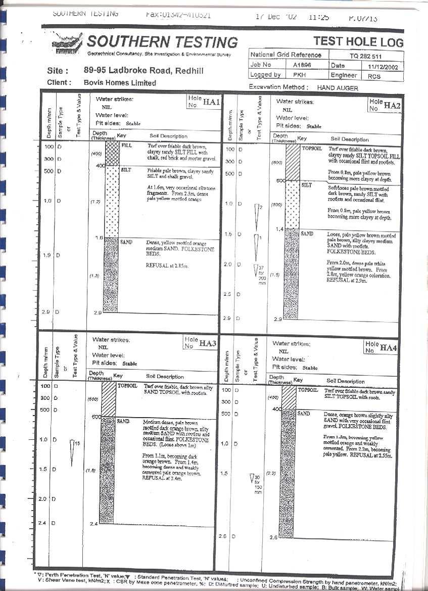
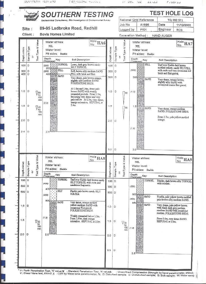
8 The First Edition Ordnance Survey, 1872, (Fig. 5) shows some significant development on the site. One large property appears now to occupy the site, with a large plot of land to the rear laid out as formal gardens. A second building is also present but this appears to be associated with the garden, rather than a residential dwelling. All of the properties at the northern end of the street appear quite substantial with large associated gardens perhaps suggesting this was a fairly affluent area at this time. The Second Edition Ordnance Survey of 1896 (Fig. 6) shows a few minor changes on the site. The property has been subdivided to create two distinct areas. The new boundary to the south of the original building appears to correspond roughly with the southern edge of the development area. An additional building has also appeared to the rear of the large structure. The 1913 Edition Ordnance Survey (Fig. 7) indicates some significant changes in the area. To the north west of the site, and forming this boundary for the development area, Lynwood Road has now been developed. The area of the large house has not changed much although the additional building noted on the previous map has now gone. The small area north of the large property has now been divide up into two plots of land, one appears to be in use as an orchard and has a small structure located in its the north west corner. According to the Ordnance Survey of 1935 (Fig. 8), very little has changed. The northern area of the site is now open land, which is associated with a building outside the development area. However by the Ordnance Survey of 1967 (Fig. 9) the site and its surrounding area have changed substantially. Ladbroke Road has taken on the form familiar today. Rows of detached houses now line the street, and the plots of 89 to 95 are clearly visible. The larger structure noted above, which appears to have been on the site from at least the late 19th century, has now been replaced by the properties at 91 and 91a Ladbroke Road. Geotechnical test pits A geotechnical survey carried out by Southern Testing (2002) recorded 9 hand-dug augers across the site, the results of these are listed in Appendix 3. In summary, the test pits encountered the natural sand of the Folkestone Beds at depths of either c. 0.40m or c. 1.4m. Where the sand was deeper, intervening layers of silt and or made ground ( fill in Appendix 3) were encountered. It is unclear if the silt is a natural deposit or has been imported to level up the site for landscaping. Given that landscaping does seem to have occurred, the latter may be more likely. This may in turn be taken to imply that significant truncation of the natural (and, presumably, of any archaeologically relevant levels) has not taken place. 6
9 Discussion In considering the archaeological potential of the study area, various factors must be taken into account, including previously recorded archaeological sites, previous land-use and disturbance, the area of the site and future land-use including the proposed development. The cartographic and historical sources indicate that the site has undergone relatively little development in its more recent history. From the late 19th century onwards the site was occupied by one property which appears to have been removed to make space for the current properties on Ladbroke Road. It is possible, however, that any archaeological deposits present on the site will be relatively undisturbed due to the lack of development on the site during its more recent history. As indicated above, the origins of Redhill appear to be of late post-medieval date. The survey of the SMR indicates that there was some, albeit limited, earlier activity. The Mesolithic flint scatter hints at very early occupation of the area, but beyond this little, or no, prehistoric activity is noted. Perhaps the most significant find on the SMR is the Roman pot retrieved from the house at 96 Ladbroke Road, in close proximity to the proposal site which could indicate Roman activity within the vicinity. In general the site appears to have low to moderate archaeological potential. The SMR, historical sources and fieldwork within the vicinity of the site all suggest that there is little activity in this area. However one factor to be taken into account is the size of the site. The Surrey Structure Plan (1994) states that archaeological assessment or evaluation will also be required prior to development on sites of 0.4 hectares or more. This site slightly exceeds this limit and therefore further investigation may be requested. If this is the case it may be necessary to provide further information about the potential of the site from field observations in order to draw up a scheme to mitigate the impact of development on any below-ground archaeological deposits. A scheme for such an evaluation would need to be drawn up and approved by the archaeological advisers to the Borough and implemented by a competent archaeological contractor. The information provided by the fieldwork can be used to draw up a mitigation strategy to minimize the effects of development on any archaeological deposits present. References BGS, 1978, British Geological Survey, Sheet 286, Drift Edition, 1:50000, Keyworth Ellaby, R, 1987, the Upper Palaeolithic and Mesolithic in Surrey, in J Bird and D G Bird (eds), The Archaeology of Surrey to 1540, Surrey Archaeological Society, Guildford Field, D and Cotton, J, 1987, Neolithic surrey: a survey of the evidence in J Bird and D G Bird (eds), The Archaeology of Surrey to 1540, Surrey Archaeological Society, Guildford Jackson, G, Maloney, C and Saich, D, 1999, Archaeology in Surrey , Surrey Archaeol Collect, 86 Mills, A D, 1998, Dictionary of English Place Names, Oxford PPG16, 1990, Dept of the Environment Planning Policy Guidance 16, Archaeology and Planning, HMSO 7
10 Pollinger, L, 1997, Redstone Annex site, Redhill, Surrey, An Archaeological Watching Brief, Thames Valley Archaeological Services report 97/59, Reading Poulton, R, 1987, Saxon Surrey in J Bird and D G Bird (eds), The Archaeology of Surrey to 1540, Surrey Archaeological Society, Guildford O Connell, M, 1977, Historic Towns in Surrey, Surrey Archaeological Society, Guildford Saunders, M J and Weaver, S, (forthcoming), The excavation of a late Iron Age/Early Roman settlement enclosure and prehistoric and early/middle Saxon deposits at Battlebridge Lane, Merstham, Surrey 1999 Thames Valley Archaeological Services draft publication report 98/65, Reading Southern Testing, 2002, Preliminary Site Assessment Report; Ladbroke Road, Redhill, report A1896, East Grinstead Turner, D, J, 1987, Archaeology of Surrey, , in J Bird and D G Bird (eds), The Archaeology of Surrey to 1540, Surrey Archaeological Society, Guildford VCH, 1967, Victorian County History, Surrey, 1 and III, University of London Institute of Historical Research Williams, A and Martin, G H, 2002, Domesday Book, A Complete Translation, London 8
11 APPENDIX 1: Sites and Monuments Records within a xx m search radius of the development site No SMR Ref Grid Ref (SU) Type Period Comment Double headed flint axe Neolithic/Bronze Age Coins Roman Coins of Vespasian, Nero and other emperors Chipping Floor Mesolithic Located close to Redhill station possible pits?neolithic Pottery Roman 1st-2nd Century Coin Roman Follis of Constantine I 4th Century Milestone Post Medieval London to Brighton Road Wall Watching brief by TVAS Negative evidence Evaluation found nothing. 9
12 APPENDIX 2: Historic and modern maps consulted 1575 Saxton s map of Surrey 1594 Norden s map of Surrey 1605 Van den Keere s map of Surrey 1611 Speed s map of Surrey 1693 Seller s map of Surrey 1729 Senex map of Surrey 1768 Rocque s map of Surrey 1829 Greenwoods map of Surrey 1846 Reigate Tithe map 1872 First Edition Ordnance Survey, Surrey Sheet XXVI Second Edition Ordnance Survey, Surrey Sheet XXVI Third Edition ordnance Survey, Surrey Sheet XXVI Ordnance Survey, Surrey Sheet XXVI Ordnance Survey Sheet TQ 28/50 & 29/ Ordnance Survey Sheet TQ 28/51 & 29/ Ordnance Survey Sheet TQ 25/35 10
13 APPENDIX 3: Geotechnical survey results 11
14
15
16

17 Prehistoric Post medieval SITE Roman Undated/ Negative SITE TQ Ladbroke Road, Redhill, Surrey, 2003 LRR 03/36 Figure 1. Location of site within Redhill and Surrey. Reproduced from Ordnance Survey Pathfinder 1190 TQ25/35 1:25000 Ordnance Survey Licence AL52324A0001

18 SITE Ladbroke House, Redhill, Surrey, 2003 LRR 03/36 Figure 2. Rocque s map 1768.

19 SITE Ladbroke Road, Redhill, Surrey, 2003 LRR 03/36 Figure 3.Greenwood s Map 1829

20 SITE Ladbroke Road, Redhill, Surrey, 2003 LRR 03/36 Figure 4. Reigate Tithe Map, 1846

21 SITE Ladbroke Road, Redhill, Surrey 2003 LRR 03/36 Figure 5. First Editon Ordnance Survey, 1872

22 SITE Ladbroke Road, Redhill, Surrey, 2003 LRR03/36 Figure 6. Second Edition Ordnance Survey, 1896.

23 SITE Ladbroke Road, Redhill, Surrey, 2003 LRR03/360 Figure 7. Third Edition Ordnance Survey, 1913

24 SITE Ladbroke Road, Redhill, Surrey, 2003 LRR 03/36 Figure Edition Ordnance Survey Reproduced from Ordnance Survey Pathfinder 1190 TQ06/16 1:25000 Ordnance Survey Licence AL52324A0001


25 SITE Ladbroke Road, Redhill, Surrey, 2003 LRR 03/36 Figure Ordnance Survey Reproduced from Ordnance Survey TQ28/51&TQ29/51, TQ28/50 & TQ29/50 1:25000
Addington Village Farm, Addington Village Road, London Borough of Croydon
 Addington Village Farm, Addington Village Road, London Borough of Croydon An Archaeological Desk-Based Assessment for Bewley Homes PLC by Steve Ford Thames Valley Archaeological Services Site Code ARC00/47
The Coach House, Mill Lane, Cookham, Berkshire
 The Coach House, Mill Lane, Cookham, Berkshire An Archaeological Watching Brief For Ms Sophia Butler by Stephen Hammond Thames Valley Archaeological Services Ltd Site Code CMC 03/104 October 2003 Summary
The Old Shire Horse Centre, Bath Road, Woolley Green, Maidenhead, Berkshire
 The Old Shire Horse Centre, Bath Road, Woolley Green, Maidenhead, Berkshire An Archaeological Watching Brief For Mr Derek Chesterman by Andrew Mundin Thames Valley Archaeological Services Ltd Site Code
Holyport Manor Special School, Highfield Lane, Cox Green, Maidenhead, Berkshire
 Holyport Manor Special School, Highfield Lane, Cox Green, Maidenhead, Berkshire An Archaeological recording action For CgMs Consulting by Jennifer Lowe Thames Valley Archaeological Services Ltd Site Code
Cholesbury New House, Parrots Lane, Cholesbury, Buckinghamshire
 Cholesbury New House, Parrots Lane, Cholesbury, Buckinghamshire An Archaeological Watching Brief For Mr Martin Wood by Sean Wallis Thames Valley Archaeological Services Ltd Site Code PLC 06/135 March 2007
Wheatlands House, Fleet Hill, Finchampstead, Berkshire
 Wheatlands House, Fleet Hill, Finchampstead, Berkshire An Archaeological Watching Brief For JCA International by James McNicoll-Norbury Thames Valley Archaeological Services Ltd Site Code WFF 08/26 August
Henderson Mess, RAF Halton, Buckinghamshire
 Henderson Mess, RAF Halton, Buckinghamshire An archaeological watching brief for Stepnell Ltd by Stephen Hammond Thames Valley Archaeological Services Ltd Site Code RHA03/85 October 2003 Summary Site name:
104 Bancroft, Hitchin, Hertfordshire
 104 Bancroft, Hitchin, Hertfordshire An Archaeological Desk-Based Assessment for William Ransom and Son plc by Jennifer Lowe Thames Valley Archaeological Services Ltd Site Code BHH 03/88 September 2003
Aylesbury Masonic Hall, Ripon Street, Aylesbury, Buckinghamshire
 Aylesbury Masonic Hall, Ripon Street, Aylesbury, Buckinghamshire An Archaeological Recording Action for Wakefield Building Services by Andrew Mundin Thames Valley Archaeological Services Ltd Site Code
ARCHAEOLOGICAL S E R V I C E S. Phase 5, Grimsby Road, Cippenham, Slough, Berkshire. Archaeological Recording Action.
 T H A M E S V A L L E Y ARCHAEOLOGICAL S E R V I C E S Phase 5, Grimsby Road, Cippenham, Slough, Berkshire Archaeological Recording Action by Andy Taylor Site Code: GRC13/57 (SU 9493 7977) Phase 5, Eltham
Land off Birdie Way, Rush Green, Hertford, Hertfordshire
 Land off Birdie Way, Rush Green, Hertford, Hertfordshire An Archaeological Evaluation for Bride Hall Development Limited by Sarah Coles Thames Valley Archaeological Services Site Code RGH00/ 01 January
S E R V I C E S. Land to the rear of Ashdown, Basingstoke Road, Spencers Wood, Reading, Berkshire. Archaeological Evaluation.
 T H A M E S V A L L E Y ARCHAEOLOGICAL S E R V I C E S Land to the rear of Ashdown, Basingstoke Road, Spencers Wood, Reading, Berkshire Archaeological Evaluation by Susan Porter Site Code: ASW12/21 (SU
S E R V I C E S. Land at Wyeth Pharmaceuticals, Huntercombe Lane South, Taplow, Berkshire. An archaeological recording action.
 T H A M E S V A L L E Y ARCHAEOLOGICAL S E R V I C E S Land at Wyeth Pharmaceuticals, Huntercombe Lane South, Taplow, Berkshire An archaeological recording action By Daniel Bray WLS12/150 (SU 9339 8088)
Florence House, High Street, Hurley, Berkshire
 Florence House, High Street, Hurley, Berkshire An Archaeological Watching Brief For Mr Michael Waterhouse by Jo Pine Thames Valley Archaeological Services Ltd Site Code FHH04/52 May 2004 Summary Site name:
o a London Borough of Barnet Stoney Wood Lake Silk Stream Flood Alleviation Scheme Archaeological Watching Brief Report Oxford Archaeology
 Silk Stream Flood Alleviation Scheme Stoney Wood Lake London Borough of Barnet Archaeological Watching Brief Report o a Oxford Archaeology November 2004 Client: Halcrow on behalf of Environment Agency
Following the initial soil strip archaeology is sprayed up prior to planning and excavation
 Barton Quarry & Archaeology Over the past half century quarries have been increasingly highlighted as important sources of information for geologists, palaeontologists and archaeologists, both through
Wessex Archaeology. Little Stubbings, West Amesbury, Salisbury, Wiltshire. Archaeological Watching Brief. Ref:
 Wessex Archaeology Little Stubbings, West Amesbury, Salisbury, Wiltshire Ref: 63280.02 March 2007 LITTLE STUBBINGS, WEST AMESBURY, NR SALISBURY, WILTSHIRE ARCHAEOLOGICAL WATCHING BRIEF Prepared for: P
Archaeological Watching Brief on land at Alpha, Gore Road, Eastry, Kent July 2010
 Archaeological Watching Brief on land at Alpha, Gore Road, Eastry, Kent July 2010 SWAT. Archaeology Swale and Thames Archaeological Survey Company School Farm Oast, Graveney Road Faversham, Kent ME13 8UP
BRONZE AGE FIELD SYSTEM AT SOUTHAMPTON AIRPORT
 Proc. Hampshire Field Club Archaeol. Soc. 65, 2010, 1-6 (Hampshire Studies 2010) BRONZE AGE FIELD SYSTEM AT SOUTHAMPTON AIRPORT By J SULIKOWSKA With contributions by LORRAINE MEPHAM and CHRIS J STEVENS
Manor Farm, Wilcot, Pewsey, Wiltshire
 Manor Farm, Wilcot, Pewsey, Wiltshire An Archaeological Evaluation for Mr W. Madiment by Helen Moore Thames Valley Archaeological Services Ltd Site Code MFP02/78 September 2002 Summary Site name: Manor
Land adjacent to North Shoebury Road, Southend-on-Sea, Essex
 Land adjacent to North Shoebury Road, Southend-on-Sea, Essex An Archaeological Desk-Based Assessment for Swan Hill Homes By Sian Anthony Thames Valley Archaeological Services Ltd Site Code SSE 03/50 July
Archaeological Evaluation Report
 Holywell House Osney Mead Oxford o a November 2007 Client: Knowles and Son Issue N o : 1 OA Job N o : 3826 Planning Ref N o : 02/01800/FUL NGR: SP 502 055 Client Name: Knowles and Son Client Ref No: Document
Excavations in a Medieval Market Town: Mountsorrel, Leicestershire,
 Excavations in a Medieval Market Town: Mountsorrel, Leicestershire, by John Lucas Mountsorrel is situated 12 kms north of Leicester and forms a linear settlement straddling the A6, Leicester to Derby road.
Archaeological Investigations Project South East Region SOUTHAMPTON 2/842 (C.80.C004) SU
 SU") SOUTHAMPTON City of Southampton 2/842 (C.80.C004) SU 4382 1336 125 BITTERNE ROAD WEST, SOUTHAMPTON Report on the Archaeological Evaluation Excavation at 125 Bitterne Road West, Southampton Russel, A. D
SOUTHAMPTON City of Southampton 2/842 (C.80.C004) SU 4382 1336 125 BITTERNE ROAD WEST, SOUTHAMPTON Report on the Archaeological Evaluation Excavation at 125 Bitterne Road West, Southampton Russel, A. D
Archaeological Watching Brief at the Brick Stables and Wagon Lodge, Abbey Barns, Abbey Road, Faversham, Kent September 2010
 Archaeological Watching Brief at the Brick Stables and Wagon Lodge, Abbey Barns, Abbey Road, Faversham, Kent September 2010 SWAT. Archaeology Swale and Thames Archaeological Survey Company School Farm
An archaeological excavation at 193 High Street, Kelvedon, Essex September 2009
 An archaeological excavation at 193 High Street, Kelvedon, Essex September 2009 report prepared by Ben Holloway and Howard Brooks on behalf of Marden Homes CAT project ref.: 09/4g NGR: TL 8631 1913 (c)
The Archaeology of Cheltenham
 The Archaeology of Cheltenham The archaeology collection of The Wilson contains a rich quantity of material relating to the prehistoric and Roman occupation of the North Cotswolds and parts of the Severn
ARCHAEOLOGICAL S E R V I C E S S O U T H. Newhaven Primary School, Newhaven, East Sussex. Archaeological Desk-based Assessment.
 T H A M E S V A L L E Y ARCHAEOLOGICAL S E R V I C E S S O U T H Newhaven Primary School, Newhaven, East Sussex Archaeological Desk-based Assessment by Sean Wallis Site Code NSN14/110 (TQ 4401 0056) 02000
Archaeological Monitoring at Ham Farm, Ham Road, Faversham, Kent
 Archaeological Monitoring at Ham Farm, Ham Road, Faversham, Kent NGR: 601750.0mE 162695.0mN Site Code HAM/WB/12 Report for A.J. Bray SWAT ARCHAEOLOGY Swale and Thames Archaeological Survey Company The
Northamptonshire Archaeology
 Northamptonshire Archaeology A programme of archaeological observation, investigation and recording at St Andrews Church, Spratton, Northamptonshire Northamptonshire Archaeology 2 Bolton House Wootton
South West Region GLOUCESTERSHIRE 1/405 (B.23.H005) SU
 SU") GLOUCESTERSHIRE Cotswold 1/405 (B.23.H005) SU 16559880 COTSWOLD EASTERN SPINE ROAD STAGE 4 Cotswold Eastern Spine Road Stage 4 and Horcott Road. Watkins, K Gloucester : Gloucestershire County Council Archaeology
GLOUCESTERSHIRE Cotswold 1/405 (B.23.H005) SU 16559880 COTSWOLD EASTERN SPINE ROAD STAGE 4 Cotswold Eastern Spine Road Stage 4 and Horcott Road. Watkins, K Gloucester : Gloucestershire County Council Archaeology
Depot. Chapel. El Sub Sta. 43 to 53 to to m
 BLANK PAGE 34 50 8 54 3 67 9 to 9 88 40 to 6 8 LONG RO 8 Depot 9 to 6 4 to 8 3 6 JOHN 8 Chapel 6 Works 3 7 to 4 5 4 6 William Dalby Walk 8 0 6 35 9 5 4 99 97 95 93 89 9 85 87 UNSTON ROAD 07.0m 4 El Sub
Afon Adda Refurbishment Bangor
 Afon Adda Refurbishment Bangor Archaeological Assessment Revised Report GAT Project No. 1876 Report No. 628 April 2006 Ymddiriedolaeth Archaeolegol Gwynedd Gwynedd Archaeological Trust Craig Beuno, Ffordd
An archaeological excavation and watching brief at the Musket Club, Homefield Road, Colchester, Essex December 2004-February 2005
 An archaeological excavation and watching brief at the Musket Club, Homefield Road, Colchester, Essex December 2004-February 2005 report prepared by Howard Brooks on behalf of RMPA and the MoD CAT project
THE HEUGH LINDISFARNE
 LINDISFARNE COMMUNITY ARCHAEOLOGY THE HEUGH LINDISFARNE Archaeological excavations in June 2017 Invitation to volunteers THE HEUGH, LINDISFARNE, NORTHUMBERLAND: ARCHAEOLOGICAL EXCAVATIONS 2017 INTRODUCTION
An archaeological watching brief on land adjacent to 50 Rosebery Avenue, Colchester, Essex May/June 2003
 An archaeological watching brief on land adjacent to 50 Rosebery Avenue, Colchester, Essex May/June 2003 report prepared by C Crossan on behalf of Highfield Homes Ltd NGR: TM 0035 2500 CAT project ref.:
Long Cairn Divis County Antrim
 Survey Report No. 66 Harry Welsh Long Cairn Divis County Antrim 2 Ulster Archaeological Society 2018 Ulster Archaeological Society c/o School of Natural and Built Environment Queen s University Belfast
East Midlands Region LEICESTER 3/16 (E.62.A010) SK
 SK") LEICESTER City of Leicester 3/16 (E.62.A010) SK 5853 0433 12 NEW ST., CASTLE WARD, LEICESTER Cottage to the Rear of 12 New St., Castle Ward, Leicester - A Photographic Survey and Archaeological Watching
LEICESTER City of Leicester 3/16 (E.62.A010) SK 5853 0433 12 NEW ST., CASTLE WARD, LEICESTER Cottage to the Rear of 12 New St., Castle Ward, Leicester - A Photographic Survey and Archaeological Watching
South East Region SOUTHAMPTON 3/1050 (E.80.H006) SU
 SU") SOUTHAMPTON 3/1050 (E.80.H006) SU 43351328 16 HAWKESWOOD ROAD Report on the Archaeological Observations at 16 Hawkeswood Road, Bitterne Manor Russil, A & Smith, M Southampton : Southampton City Council
SOUTHAMPTON 3/1050 (E.80.H006) SU 43351328 16 HAWKESWOOD ROAD Report on the Archaeological Observations at 16 Hawkeswood Road, Bitterne Manor Russil, A & Smith, M Southampton : Southampton City Council
An archaeological evaluation at 14 Vineyard Street, Colchester, Essex March 2006
 An archaeological evaluation at 14 Vineyard Street, Colchester, Essex March 2006 report prepared by Ben Holloway commissioned by Colchester Borough Council CAT project code: 06/4b Colchester Museums accession
N18 Ennis Bypass and N85 Western Relief Road. Site AR125, Clareabbey, Co. Clare
 N18 Ennis Bypass and N85 Western Relief Road Site AR125, Clareabbey, Co. Clare Final Archaeological Excavation Report for Clare County Council Licence No: 04E0023 by Graham Hull Job J04/02 (NGR 134366
Archaeological Investigations Project Yorkshire & Humberside Region NORTH YORKSHIRE 2/1113 (C.36.J002) SD
 SD") NORTH YORKSHIRE Craven 2/1113 (C.36.J002) SD 93607800 CRAY BECK, BUCKDEN, UPPER WHARFEDALE Cray Beck, The Archaeological Investigation of a Stone Feature Archetype Wensleydale : ArcheType Archaeological
NORTH YORKSHIRE Craven 2/1113 (C.36.J002) SD 93607800 CRAY BECK, BUCKDEN, UPPER WHARFEDALE Cray Beck, The Archaeological Investigation of a Stone Feature Archetype Wensleydale : ArcheType Archaeological
Greater London Region GREATER LONDON 1 /186 (B ) TQ
 TQ") GREATER LONDON City of Westminster 1 /186 (B.01.6114) TQ 30378110 11-14 HANOVER PLACE, 49-52 FLORAL STRET, 7-12 BOW STREET, 55-59 LONG ACRE, 19-20 BOW STREET & 5-9 B 11-14 Hanover Place, 49-52 Floral Street,
GREATER LONDON City of Westminster 1 /186 (B.01.6114) TQ 30378110 11-14 HANOVER PLACE, 49-52 FLORAL STRET, 7-12 BOW STREET, 55-59 LONG ACRE, 19-20 BOW STREET & 5-9 B 11-14 Hanover Place, 49-52 Floral Street,
Chiselbury Camp hillfort
 Chiselbury Camp hillfort Reasons for Designation Large univallate hillforts are defined as fortified enclosures of varying shape, ranging in size between 1ha and 10ha, located on hilltops and surrounded
South East Region SURREY 3/1128 (E.43.A017) TQ
 TQ") SURREY Elmbridge 3/1128 (E.43.A017) TQ 0854 6171 ARDENNE COTTAGE, ST GEORGE'S HILL, WEYBRIDGE An Archaeological Watching Brief at Ardenne Cottage, St George's Hill, Weybridge Stevenson, J Woking : Surrey
SURREY Elmbridge 3/1128 (E.43.A017) TQ 0854 6171 ARDENNE COTTAGE, ST GEORGE'S HILL, WEYBRIDGE An Archaeological Watching Brief at Ardenne Cottage, St George's Hill, Weybridge Stevenson, J Woking : Surrey
Archaeological Investigations Project Eastern Region. Essex 2/197 (C.22.F025) TL
 TL") Essex Braintree 2/197 (C.22.F025) TL 75502284 BLANDFORD HOUSE, 7 LONDON ROAD, BRAINTREE Blandford House, 7 London Road, Braintree, Essex Davis, E Chelmsford : Essex County Council Field Archaeology Unit,
Essex Braintree 2/197 (C.22.F025) TL 75502284 BLANDFORD HOUSE, 7 LONDON ROAD, BRAINTREE Blandford House, 7 London Road, Braintree, Essex Davis, E Chelmsford : Essex County Council Field Archaeology Unit,
South East WEST SUSSEX 3/1146 (E ) SU
 SU") WEST SUSSEX Arun 3/1146 (E.45.6000) SU 97370032 'GREENFIELDS', MIDDLETON-ON-SEA 'Greenfields', Middleton-on-Sea, West Sussex. Archaeological Excavation Saunders, M J Reading : Thames Valley Archaeological
WEST SUSSEX Arun 3/1146 (E.45.6000) SU 97370032 'GREENFIELDS', MIDDLETON-ON-SEA 'Greenfields', Middleton-on-Sea, West Sussex. Archaeological Excavation Saunders, M J Reading : Thames Valley Archaeological
Investigations at Jackdaw Crag Field, Boston Spa, SE , in by Boston Spa Archaeology and Heritage Group
 0 Investigations at Jackdaw Crag Field, Boston Spa, SE 42304632, in 2006-7 by Boston Spa Archaeology and Heritage Group www.bostonspaheritage.co.uk Preface and Summary This report records the results of
ROUKEN GLEN: BANDSTAND 2015 DATA STRUCTURE REPORT
 ROUKEN GLEN: BANDSTAND 2015 DATA STRUCTURE REPORT Author (s) Ian Hill Editors Report Date June 2015 Working Partners Funders Phil Richardson East Renfrewshire Council East Renfrewshire Council, Heritage
A21 TONBRIDGE TO PEMBURY DUALLING. Statement of Case
 A21 TONBRIDGE TO PEMBURY DUALLING Statement of Case In Respect of Applications for the Demolition of Listed Buildings Under the Provisions of the Planning (Listed Buildings and Conservation Areas) Act
FORMER COUNTY OF SOUTH YORKSHIRE
 FORMER COUNTY OF SOUTH YORKSHIRE Barnsley 3/1883 (E.04.6010) SE 36491121 4 CHURCH HILL, ROYSTON 4 Church Hill, Royston, South Yorkshire. Archaeological Watching Brief (Report No. 868) O'Neill, R Leeds
4. Bronze Age Ballybrowney, County Cork Eamonn Cotter
 4. Bronze Age Ballybrowney, County Cork Eamonn Cotter Illus. 1 Location map of the excavated features at Ballybrowney Lower (Archaeological Consultancy Services Ltd, based on the Ordnance Survey Ireland
Report on an archaeological watching brief at Thomas Lord Audley School, Monkwick, Colchester
 Report on an archaeological watching brief at Thomas Lord Audley School, Monkwick, Colchester July 2000 for WS Atkins Property Services Colchester Archaeological Trust 12 Lexden Road, Colchester, Essex
E&M West Buildings Union Street, Aberdeen, AB10 1GD
 E&M West Buildings 32-38 Union Street, Aberdeen, AB10 1GD 30 November 2011 E&M West Buildings 32-38 Union Street, Aberdeen, AB10 1GD CONTENTS 1 INTRODUCTION 3 2 ARCHAEOLOGICAL BACKGROUND 4 3 THE WATCHING
South West DORSET 3/1305 (E ) SY
 SY") DORSET East Dorset 3/1305 (E.19.6510) SY 93008000 COGDEAN ELMS, CORFE MULLEN Archaeological Watching Brief at Cogdean Elms, Corfe Mullen, Dorset (Doc.no.00.28) Manning, P T Exeter : Exeter Archaeology,
DORSET East Dorset 3/1305 (E.19.6510) SY 93008000 COGDEAN ELMS, CORFE MULLEN Archaeological Watching Brief at Cogdean Elms, Corfe Mullen, Dorset (Doc.no.00.28) Manning, P T Exeter : Exeter Archaeology,
Beech House, F ordham Road, Exning, Suffolk
 Beech House, F ordham Road, Exning, Suffolk An Archaeological Monitoring of Works. Dave Webb CAMBRIDGE ARCHAEOLOGICAL UNIT UNIVERSITY OF CAMBRIDGE Archaeological Monitoring of works at Beech House, Fordham
Street Sweeper Dump Site, RAF Lakenheath ERL 160
 ARCHAEOLOGICAL MONITORING REPORT Street Sweeper Dump Site, RAF Lakenheath ERL 160 A REPORT ON THE ARCHAEOLOGICAL MONITORING, 2006 (Planning app. no. F/2006/0021/GOV) Jo Caruth Field Team Suffolk C.C. Archaeological
South East Region MILTON KEYNES 3/951 (E.66.H019) SP
 SP") MILTON KEYNES 3/951 (E.66.H019) SP 48892517 100/102 HIGH STREET, OLNEY 100/102 High Street, Olney, Milton Keynes Lisboa, I Milton Keynes : Archaeologica, 2002, 23pp, figs, tabs, refs An archaeological
MILTON KEYNES 3/951 (E.66.H019) SP 48892517 100/102 HIGH STREET, OLNEY 100/102 High Street, Olney, Milton Keynes Lisboa, I Milton Keynes : Archaeologica, 2002, 23pp, figs, tabs, refs An archaeological
NORTH YORKSHIRE 2/1340 (C ) SE
 SE") NORTH YORKSHIRE Craven 2/1339 (C.36.6001) SD 97606975 SD 94507750 KILNSEY TO BUCKDEN WATER PIPELINE Kilnsey to Buckden Water Pipeline, North Yorkshire. Geophysical Survey (Report no. 841) Webb, A Leeds
NORTH YORKSHIRE Craven 2/1339 (C.36.6001) SD 97606975 SD 94507750 KILNSEY TO BUCKDEN WATER PIPELINE Kilnsey to Buckden Water Pipeline, North Yorkshire. Geophysical Survey (Report no. 841) Webb, A Leeds
An archaeological watching brief on a new cable trench at the Abbey Field sports pitches, Circular Road North, Colchester, Essex October 2006
 An archaeological watching brief on a new cable trench at the Abbey Field sports pitches, Circular Road North, Colchester, Essex report prepared by Ben Holloway on behalf of Atkins Defence CAT project
Greater London Region GREATER LONDON 1/204 (B.01.A131) TQ
 TQ") GREATER LONDON City of Westminster 1/204 (B.01.A131) TQ 2911 8076 10-13 OLD BURLINGTON STREET, 19 CLIFFORD STREET AND 30-32 SAVILE ROW 10-13 Old Burlington Street, 19 Clifford Street and 30-32 Savile Row,
GREATER LONDON City of Westminster 1/204 (B.01.A131) TQ 2911 8076 10-13 OLD BURLINGTON STREET, 19 CLIFFORD STREET AND 30-32 SAVILE ROW 10-13 Old Burlington Street, 19 Clifford Street and 30-32 Savile Row,
Revision: Date: Prepared by: Checked by: Approved by: Reason for Issue: Nick Elsden (MOLA) Nick Elsden (MOLA) Page 2
 Nick Elsden (MOLA) Page 2") This document contains proprietary information. No part of this document may be reproduced without prior written consent from the chief executive of Crossrail Ltd. Revision: Date: Prepared by: Checked
This document contains proprietary information. No part of this document may be reproduced without prior written consent from the chief executive of Crossrail Ltd. Revision: Date: Prepared by: Checked
HILL-FORTS OF THE INNER TAY ESTUARY PERTH. Phase One PERTH AND KINROSS. Archaeological Survey Report. Oxford Archaeology North.
 HILL-FORTS OF THE INNER TAY ESTUARY PERTH PERTH AND KINROSS Phase One Archaeological Survey Report Oxford Archaeology North September 2012 Issue No: 2012-13/11322 OAN Job No: L10492a NGR: NO 182 153, NO
ULSTER ARCHAEOLOGICAL SOCIETY
 ULSTER ARCHAEOLOGICAL SOCIETY Survey Report: No. 52 Survey and surface artefact collection at Ballytaylor, County Antrim UAS/14/01 In association with HENRY WELSH, KARA WARD AND MOIRA O ROURKE 2 Ulster
Provincial Archaeology Office Annual Review
 2017 Provincial Archaeology Office Annual Review Provincial Archaeology Office Department of Tourism, Culture, Industry and Innovation Government of Newfoundland and Labrador March 2018 Volume 16 A brief
An archaeological watching brief at the Sixth Form College, North Hill, Colchester, Essex
 An archaeological watching brief at the Sixth Form College, North Hill, Colchester, Essex July 2001 on behalf of Colchester Borough Council CAT project ref.: 01/7B Colchester Museum accession code: 2001.126
TRANSPORT AND WORKS ACT Proof of Evidence. Andrew Wright Planning and Design Manager Taylor Wimpey East Anglia
 TRANSPORT AND WORKS ACT 1992 Proof of Evidence Andrew Wright Planning and Design Manager Taylor Wimpey East Anglia The Network Rail (Suffolk Level Crossing Reduction Order) Site at Elmswell Development
Perth and Kinross Council Development Management Committee 20 February 2013 Report of Handling by Development Quality Manager
 Perth and Kinross Council Development Management Committee 20 February 2013 Report of Handling by Development Quality Manager 4(4)(ii) 13/80 Replacement and re-positioning of street furniture, The Birks,
Archaeological evaluation at Building H11, Colchester Garrison Area A1 (former Meeanee & Hyderabad Barracks), Mersea Road, Colchester, Essex
, Mersea Road, Colchester, Essex") Archaeological evaluation at Building H11, Colchester Garrison Area A1 (former Meeanee & Hyderabad Barracks), Mersea Road, Colchester, Essex October 2013 report prepared by Ben Holloway and Howard Brooks
Archaeological evaluation at Building H11, Colchester Garrison Area A1 (former Meeanee & Hyderabad Barracks), Mersea Road, Colchester, Essex October 2013 report prepared by Ben Holloway and Howard Brooks
Perth and Kinross Council Development Control Committee 12 December 2012 Report of Handling by Development Quality Manager
 Perth and Kinross Council Development Control Committee 12 December 2012 Report of Handling by Development Quality Manager 4(3)(i) 12/570 Alterations and replacement windows at Milnathort Town Hall, 1
Gorse Stacks, Bus Interchange Excavations Interim Note-01
 Gorse Stacks, Bus Interchange Excavations 2015 Prepared for: Cheshire West & Chester Council Interim Note-01 1 Introduction & Summary Background Since c. 2000 investigations associated with redevelopment
Monitoring Report No. 227
 City of Derry Airport Longfield More townland Eglinton County Derry AE/10/61 Ruth Logue Site Specific Information Site location: City of Derry Airport, Airport Road, Eglinton, BT47 3GY Townland: Longfield
The Tel Burna Archaeological Project Report on the First Season of Excavation, 2010
 The Tel Burna Archaeological Project Report on the First Season of Excavation, 2010 By Itzick Shai and Joe Uziel Albright Institute for Archaeological Research Jerusalem, Israel April 2011 The site of
Amen Corner, Moat Lane, Towcester, Northamptonshire
 Amen Corner, Moat Lane, Towcester, Northamptonshire An Archaeological Evaluation and Desk-Based Assessment for Mr Paul Smith by Sarah Coles and Lisa Maree Hardy Thames Valley Archaeological Services Ltd
Document History continued Revision: Date: Prepared by: Checked by: Approved by: Reason for Issue:
 Document History continued Revision: Date: Prepared by: Checked by: Approved by: Reason for Issue: 1.0 29/10/2013 Gary Evans Andy Shelley Richard Brown For Acceptance Fieldwork Report CRL Ltd, 2014 Fieldwork
An archaeological watching brief at 97 High Street, Colchester, Essex March 2010
 An archaeological watching brief at 97 High Street, Colchester, Essex March 2010 report prepared by Donald Shimmin on behalf of Flying Trade Group plc CAT project ref.: 10/3a Colchester and Ipswich Museums
EAST GRINSTEAD POUNDLAND & POUNDSTRETCHER LONDON ROAD, RH19 1AG HIGH STREET RETAIL INVESTMENT OPPORTUNITY
 22-26 LONDON ROAD, RH19 1AG HIGH STREET RETAIL INVESTMENT OPPORTUNITY 22-26 LONDON ROAD, RH19 1AG INVESTMENT CONSIDERATIONS East Grinstead is a popular affluent south east commuter town Excellent communications
South East SOUTHAMPTON
 Southampton SOUTHAMPTON 3/1056 (E.80.M010) SU 44181114 SO19 7PE 1 FOREST VIEW, SOUTHAMPTON Report on the Archaeological Watching Brief at 1 Forest View, Southampton, SOU 1232 Leivers, M Southampton : Southampton
Downton, Wiltshire: archaeology and history (notes for visitors prepared by the Royal Archaeological Institute, 2017)
") Downton, Wiltshire: archaeology and history (notes for visitors prepared by the Royal Archaeological Institute, 2017) The River Avon leaves Wiltshire in Downton, a large parish that includes parts of the
Downton, Wiltshire: archaeology and history (notes for visitors prepared by the Royal Archaeological Institute, 2017) The River Avon leaves Wiltshire in Downton, a large parish that includes parts of the
East Melbourne Precinct HO2. March 2015
 East Melbourne Precinct HO2 March 2015 Local Heritage Planning Policy Review Statements of Significance Melbourne s Local Heritage Planning Policy Review project includes the preparation of statements
An archaeological fieldwalking evaluation at Tile House Farm, Great Horkesley, Essex July-September 2005
 An archaeological fieldwalking evaluation at Tile House Farm, Great Horkesley, Essex commissioned by ADP Chartered Architects on behalf of The Ingleton Properties Ltd and Mersea Homes CAT project code:
A FIELDWALKING PROJECT AT HOLLINGBURY, BRIGHTON. by JOHN FUNNELL
 Introduction A FIELDWALKING PROJECT AT HOLLINGBURY, BRIGHTON by JOHN FUNNELL Members of the Brighton and Hove Archaeological Society walked the field at Hollingbury during the months of December 1991 and
TH E FIRST SEASON of investigations at the
 QUSEIR AL-QADIM Janet H. Johnson & Donald Whitcomb TH E FIRST SEASON of investigations at the ancient port of Quseir al-qadim on the Red Sea in Egypt took place in winter, 1978; the investigations were
CHESHIRE HISTORIC TOWNS SURVEY
 CHESHIRE HISTORIC TOWNS SURVEY Eddisbury Archaeological Assessment 2003 CHESHIRE HISTORIC TOWNS SURVEY Eddisbury Archaeological Assessment 2003 Environmental Planning Cheshire County Council Backford Hall
Display of 1 no. internally illuminated advertisement hoarding
 Committee Date: 22/08/2013 Application Number: 2013/04695/PA Accepted: 01/07/2013 Application Type: Advertisement Target Date: 26/08/2013 Ward: Ladywood Summer Row, Birmingham, B3 1JU Display of 1 no.
Bridge School, Longmoor Campus, Coppice View Road, Sutton Coldfield, Birmingham, B73 6UE
 Committee Date: 22/01/2015 Application Number: 2014/05949/PA Accepted: 08/12/2014 Application Type: Full Planning Target Date: 02/02/2015 Ward: Sutton Vesey Bridge School, Longmoor Campus, Coppice View
Neale Wade Community. College, March Cambridgeshire. Desktop Assessment. Client: Cambridgeshire County Council. March 2009
 Neale Wade Community Desktop Assessment Desktop Assessment College, March Cambridgeshire March 2009 Client: Cambridgeshire County Council OA East Report No: 1095 OASIS No: Oxfordar3-56453 NGR: TL 417 952
Contents. Crossrail Limited RESTRICTED. Summary of LSS85 archive Broadgate Excavations C257-MLA-T1-XTC-C101_WS
 Summary of LSS85 archive Broadgate Excavations Contents 1 Purpose...4 2 Scope...4 3 Definitions...4 4 LSS85 Archive Summary Report...4 5 Summary Data - Burials found in Liverpool Street...5 6 Note from
SUFFOLK 2/415 (C ) TM
 TM") SUFFOLK Babergh 2/415 (C.42.6001) TM 03254360 LADY LANE, INDUSTRIAL ESTATE, HADLEIGH Lady Lane Industrial Estate, Hadleigh. A Report on an Archaeological Evaluation (2000/66) Meredith, J Ipswich : Suffolk
SUFFOLK Babergh 2/415 (C.42.6001) TM 03254360 LADY LANE, INDUSTRIAL ESTATE, HADLEIGH Lady Lane Industrial Estate, Hadleigh. A Report on an Archaeological Evaluation (2000/66) Meredith, J Ipswich : Suffolk
A21 TONBRIDGE TO PEMBURY DUALLING. Outline Statement of Case
 A21 TONBRIDGE TO PEMBURY DUALLING In Respect of Applications for the Demolition of Listed Buildings under the Provisions of the Planning (Listed Buildings and Conservation Areas) Act 1990 Appeal References:
FIELD BOUNDARIES, A MEDIEVAL STRUCTURE AND DEAD SHEEP AT IWADE, KENT
 FIELD BOUNDARIES, A MEDIEVAL STRUCTURE AND DEAD SHEEP AT IWADE, KENT Pre-Construct Archaeology Limited Unit 54, Brockley Cross Business Centre, 96 Endwell Road, Brockley, London SE4 2PD tel: 020 7732 3925
Much of the information which follows is included by kind permission of the Tynedale Council (now defunct) and is based on its brochure.
 and is based on its brochure.") The Tyne Green Trail This easy going circular walk is on level ground throughout. It follows the course of the River Tyne between Hexham Bridge and the turning point just past Watersmeet. The return is
The Tyne Green Trail This easy going circular walk is on level ground throughout. It follows the course of the River Tyne between Hexham Bridge and the turning point just past Watersmeet. The return is
JANDAKOT AIRPORT HERITAGE MANAGEMENT PLAN
 JANDAKOT AIRPORT HERITAGE MANAGEMENT PLAN CONSERVATION MANAGEMENT PLAN APPENDIX I Jandakot Airport Holdings Pty Ltd 16 Eagle Drive Jandakot WA 6164 Ref: CMP Appendix I Heritage Management Plan 2014 V1.Docx
Prehistoric and Roman remains at Beaulieu Park, Chelmsford.
 Prehistoric and Roman remains at Beaulieu Park, Chelmsford. Archaeological Evaluation Report November 2011 Client: Countryside Zest OA East Report No: 1309 OASIS No: oxfordar3-112010 NGR: TL 73081 10779
Archaeological Watching Brief Report
 Belvedere Nurseries Fenny Stratford Nr Milton Keynes Buckinghamshire Archaeological Watching Brief o oa a June 2006 Client Name: Goodsons Associates on behalf of Dobbies Garden Centre PLC Issue N o : 1
Sainsburys Store, Mere Green Road, Sutton Coldfield, Birmingham, B75 5BT
 Committee Date: 7/0/013 Application Number: 013/04/PA Accepted: 1/04/013 Application Type: Variation of Condition Target Date: 1/07/013 Ward: Sutton Four Oaks Sainsburys Store, Mere Green Road, Sutton
REPORT NUMBER 001 ARCHAEOLOGICAL DOWSING SURVEY BISHOPS SUTTON NEAR ALRESFORD HAMPSHIRE. D P BRYAN BA (Hons) MARCH 2012
 MARCH 2012") REPORT NUMBER 001 ARCHAEOLOGICAL DOWSING SURVEY AT BISHOPS SUTTON NEAR ALRESFORD HAMPSHIRE D P BRYAN BA (Hons) MARCH 2012 1 Table of Contents 1. Introduction 1.1 Project Background Page 2 1.2 Site Location
REPORT NUMBER 001 ARCHAEOLOGICAL DOWSING SURVEY AT BISHOPS SUTTON NEAR ALRESFORD HAMPSHIRE D P BRYAN BA (Hons) MARCH 2012 1 Table of Contents 1. Introduction 1.1 Project Background Page 2 1.2 Site Location
OXFORD BEFORE THE UNIVERSITY The Late Saxon and Norman Archaeology of the Thames Crossing, the Defences and the Town
 OXFORD BEFORE THE UNIVERSITY The Late Saxon and Norman Archaeology of the Thames Crossing, the Defences and the Town Edited by Anne Dodd with major contributions by Maureen Mellor, Julian Munby, Mark Robinson
ENTER EXCEPTIONAL RESIDENTIAL DEVELOPMENT OPPORTUNITY
 FOR SALE Aviator Park, Station Road, Addlestone, Surrey KT15 2PG ibrochure - www.cbre-ibrochure.co.uk/addlestone ENTER EXCEPTIONAL RESIDENTIAL DEVELOPMENT OPPORTUNITY LOCATED WITHIN THE HIGHLY DESIRABLE
Proposal for gypsy and traveller accommodation on land at Lower Hollow Copse (Pot Common), Copthorne. Statement of Community Involvement
, Copthorne. Statement of Community Involvement") Proposal for gypsy and traveller accommodation on land at Lower Hollow Copse (Pot Common), Copthorne Statement of Community Involvement Prepared by WYG Environment Planning Transport Ltd on behalf of the
Proposal for gypsy and traveller accommodation on land at Lower Hollow Copse (Pot Common), Copthorne Statement of Community Involvement Prepared by WYG Environment Planning Transport Ltd on behalf of the