A SURVEY OF DEFENDED ENCLOSURES IN CEREDIGION, 2006: GAZETTEER OF ORDNANCE SURVEY GRID SQUARES SN45 AND SN46
|
|
|
- Juliana Mason
- 5 years ago
- Views:
Transcription

1 A SURVEY OF DEFENDED ENCLOSURES IN CEREDIGION, 2006: GAZETTEER OF ORDNANCE SURVEY GRID SQUARES SN45 AND SN46 Paratowyd gan Archaeoleg Cambria Ar gyfer Cadw Prepared by Cambria Archaeology


2 ARCHAEOLEG CAMBRIA ARCHAEOLOGY RHIF YR ADRODDIAD / REPORT NO. 2006/20 RHIF Y PROSIECT / PROJECT RECORD NO Mawrth 2006 March 2006 A SURVEY OF DEFENDED ENCLOSURES IN CEREDIGION, 2006: GAZETTEER OF ORDNANCE SURVEY GRID SQUARES SN45 AND SN46 Gan / By K Murphy, R Ramsey and M Page Archaeoleg Cambria yw enw marchnata Ymddiriedolaeth Archaeolegol Dyfed Cyfyngedig. Cambria Archaeology is the marketing name of the Dyfed Archaeological Trust Limited. Paratowyd yr adroddiad yma at ddefnydd y cwsmer yn unig. Ni dderbynnir cyfrifoldeb gan Archaeoleg Cambria am ei ddefnyddio gan unrhyw berson na phersonau eraill a fydd yn ei ddarllen neu ddibynnu ar y gwybodaeth y mae n ei gynnwys The report has been prepared for the specific use of the client. Cambria Archaeology can accept no responsibility for its use by any other person or persons who may read it or rely on the information it contains. ARCHAEOLEG CAMBRIA Ymddiriedolaeth Archaeolegol Dyfed Cyf Neuadd y Sir, Stryd Caerfyrddin, Llandeilo, Sir Gaerfyrddin SA19 6AF Ffon: Ymholiadau Cyffredinol Adran Rheoli Treftadaeth Ffacs: Ebost: cambria@acadat.com Gwefan: CAMBRIA ARCHAEOLOGY Dyfed Archaeological Trust Limited The Shire Hall, Carmarthen Street, Llandeilo, Carmarthenshire SA19 6AF Tel: General Enquiries Heritage Management Section Fax: cambria@acadat.com Website: Cover: Aerial photograph of Pant Teg. RCAHMW Crown Copyright reference 2003-cs-1442.

3 SITE GAZETTEER OF 10KM GRID SQUARES SN45 and SN46 For ease of handing the site gazetteers have been arranged into Ordnance Survey 10km grid squares. Each gazetteer consists of one or more 1:50,000 maps showing the overall location of each site followed by the individual entries for each site. Each entry comprises: a printout from the Historic Environment Record, including a site description; a 1:500 map; and where available a ground photograph and an aerial photograph. Many of the 1;500 maps show details of the site plotted from cropmarks shown on aerial photographs. These plots are supplied by RCAHMW Crown Copyright. Index to the gazetteers of defended enclosures and related sites. Gazetteers are arranged by 10km grid squares.

4 1:50,000 Distribution map of sites in 10km grid square SN45. This map is reproduced from the Ordnance Survey map by the National Assembly for Wales with the permission of The Controller of Her Majesty's Stationery Office. Crown Copyright. All rights reserved. Unauthorised reproduction infringes Crown Copyright and may lead to prosecution and civil proceedings. Licence No. GD

5 1:50,000 Distribution map of sites in 10km grid square SN46. This map is reproduced from the Ordnance Survey map by the National Assembly for Wales with the permission of The Controller of Her Majesty's Stationery Office. Crown Copyright. All rights reserved. Unauthorised reproduction infringes Crown Copyright and may lead to prosecution and civil proceedings. Licence No. GD
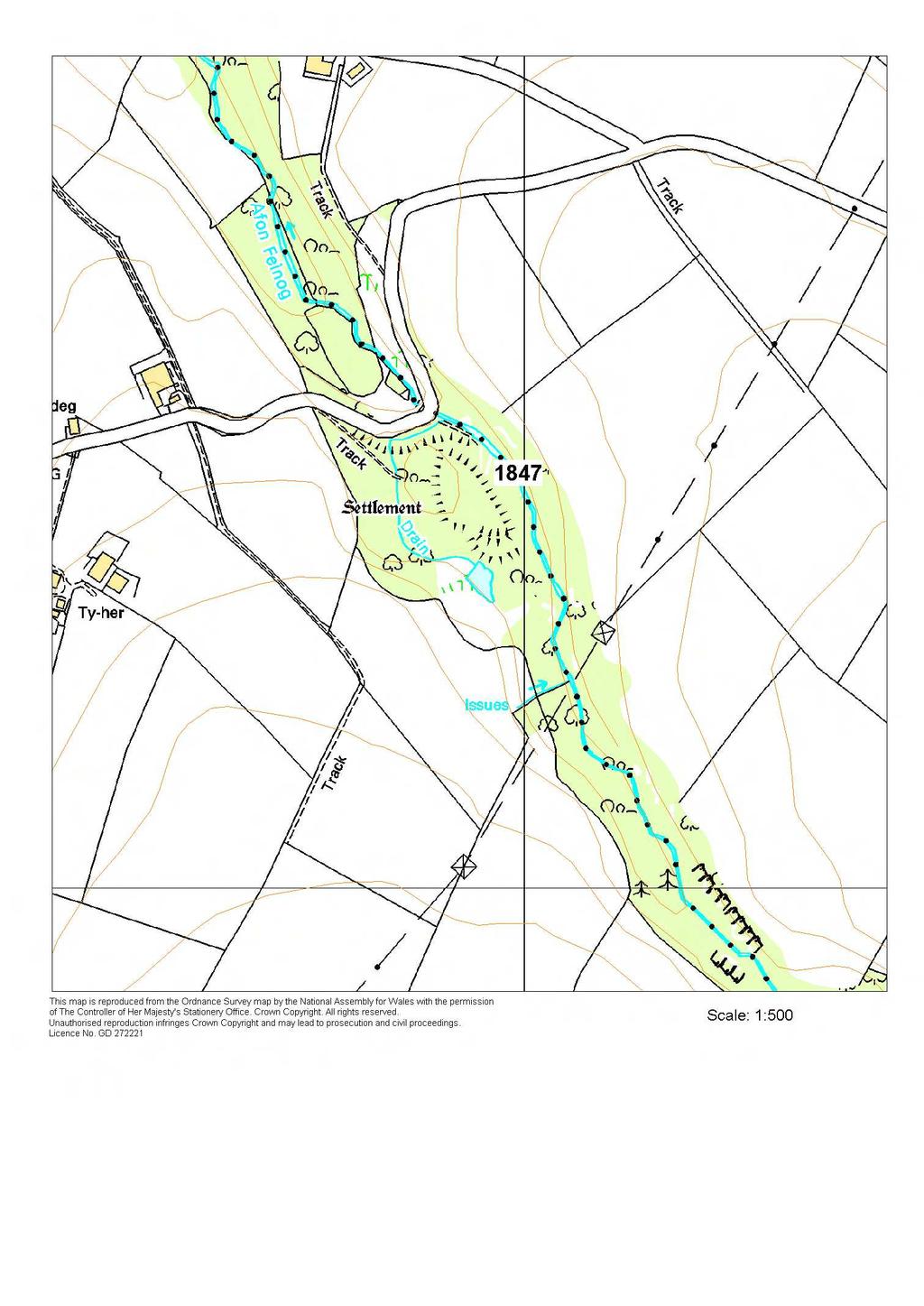
6 1847 CWM CASTELL PRN 1847 NGR SN SITE NAME CWM CASTELL SITE TYPE HILLFORT FORM Earthwork PERIOD Iron Age CONDITION C SITE STATUS SAM DESCRIPTION Cwm-castell lies in a strong naturally defended position on a knoll within a narrow valley at 170m above sea level. At its weaker south end there is a bivallate defence, with an inner bank 7m wide and 3m high fronted by a silted ditch and an outer bank 17m wide and 2m high. There is a trace of a stone revetment to the inner bank. There is a slightly in-turned entrance at the northwest end of these rampart terminals. Just north of this a platform my indicate the site of a roundhouse. A single rampart defends the remainder of the site. The internal area is irregular in shape, and measures 110m north - south and 50m east - west. The site is very overgrown with deciduous woodland, scrub and brambles. K Murphy 15 December from various descriptions.

7 Aerial photograph RCAHMW Crown Copyright reference Aerial photograph RCAHMW Crown Copyright reference 99-cs-2268.
8
9
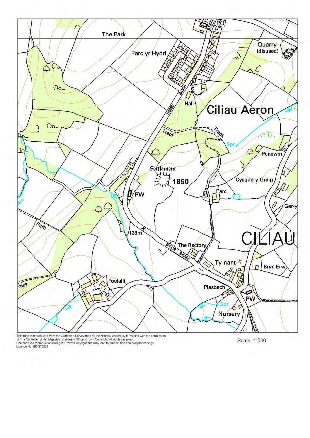
10 1850 Y GAER PRN 1850 NGR SN SITE NAME GAER Y SITE TYPE DEFENDED ENCLOSURE FORM Earthwork PERIOD Iron Age;Roman CONDITION C SITE STATUS DESCRIPTION Y Gaer is a small, earthwork defended enclosure located on a west-facing slope towards the end of a rounded inland promontory at 130m above sea level. To the north, west and south of the site the land falls away steeplyl;to the east there is a gentle rise away from the site. The enclosure is sub-rectangular in shape, approximately 40m across. A bank, approximately 8m wide and up to 0.6m high on the west side, but lower elsewhere, defines the enclosure. There is an entrance on the south side. A hedge-bank overlies the bank on the north and east sides. It is under improved pasture. K Murphy 29 November 2005

11 Ground photograph looking over earthworks.
12
13 1856 MYNACHLOG-UCHAF PRN 1856 NGR SN SITE NAME MYNACHLOG-UCHAF SITE TYPE DEFENDED ENCLOSURE FORM Earthwork PERIOD Iron Age;Roman CONDITION D SITE STATUS DESCRIPTION This is a small, earthwork, rectangular defended enclosure lying on gentle northeast-facing slopes at 270m above sea level. A hedge-bank divides the site into two unequal portions. The earthworks are better preserved in the field to the southwest of the hedge-bank; they are barely recognisable in field to the northeast. The enclosure measures approximately 50m by 40m internally. A bank with traces of an external ditch defines the site. The bank is spread and survives to only 0.2m - 0.3m high. The ditch is barely traceable. There is a low counterscarp bank to the northwest and southwest. According to the Ordnance Survey in 1974 a simple entrance lay in the northeast side. This is not now visible. The OS also reported that the earthworks were much more prominent in c The site is under improved pasture, but was under arable cultivation in K Murphy 21 November 2005

14 Ground photograph looking over slight earthworks.
15
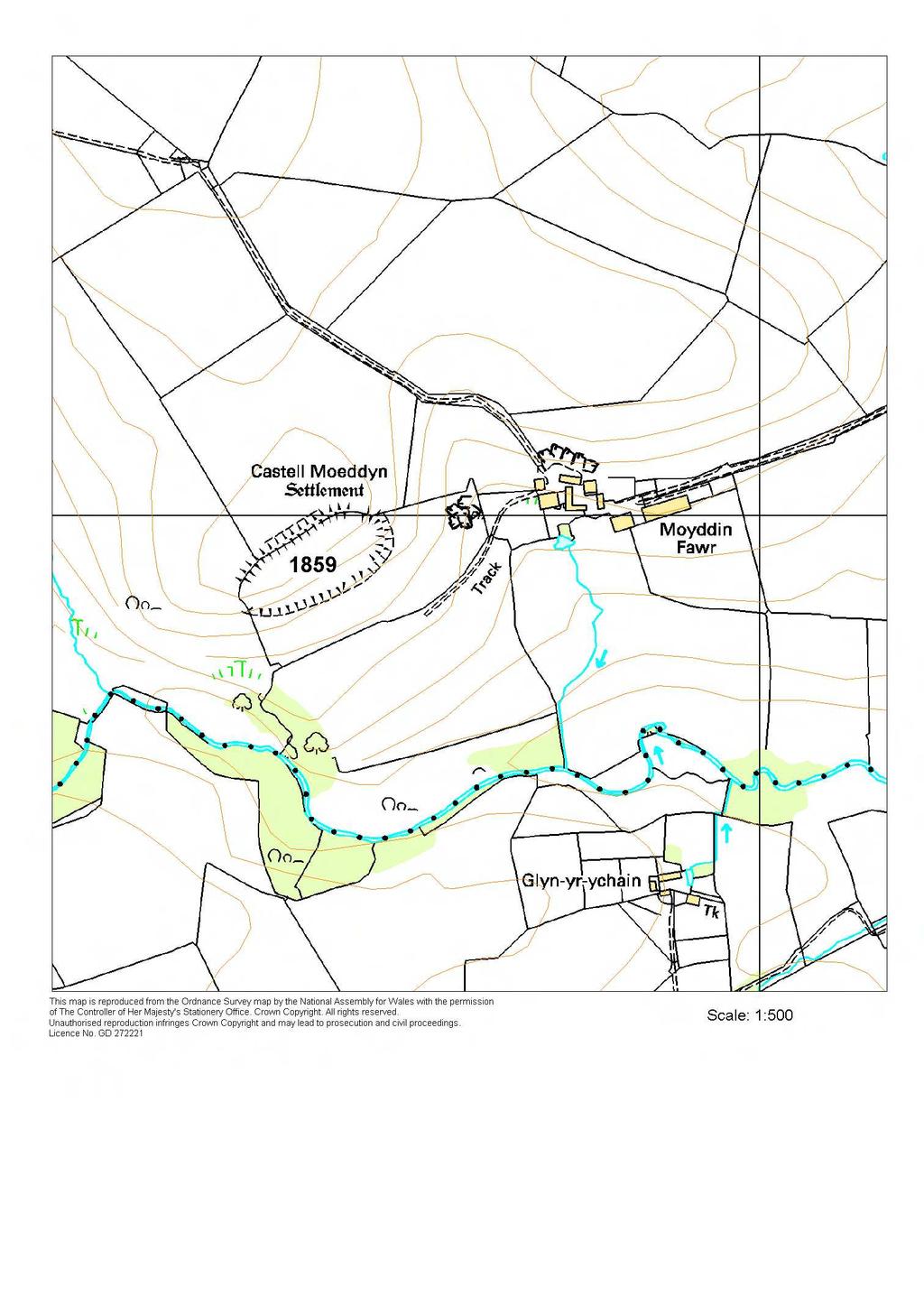
16 1859 CASTELL MOEDDYN PRN 1859 NGR SN SITE NAME CASTELL MOEDDIN SITE TYPE HILLFORT FORM Earthwork PERIOD Iron Age CONDITION C SITE STATUS SAM;ACK DESCRIPTION Castell Moeddyn lies on the southern side of a rounded hilltop at 270m above sea level in a strong naturally defended location. It is strongly defended by a rampart on the north, easily approachable side by, but more weakly defended along the steep slopes to the southwest, south and east. On these sides the hill falls steeply away to the Afon Grannell over 70m below. At its best preserved section on the northwest side the defences consist of a bank, ditch and counterscarp bank 18m wide in total and up to 4m - 5m high. A simple entrance lies on the northeast side. The interior is level, and oval in shape, measuring 175m by 78m. The site is under improved pasture, with a little scrub growth on the banks. K Murphy 15 December taken from various sources.

17 Aerial photograph Cambria Archaeology.
18
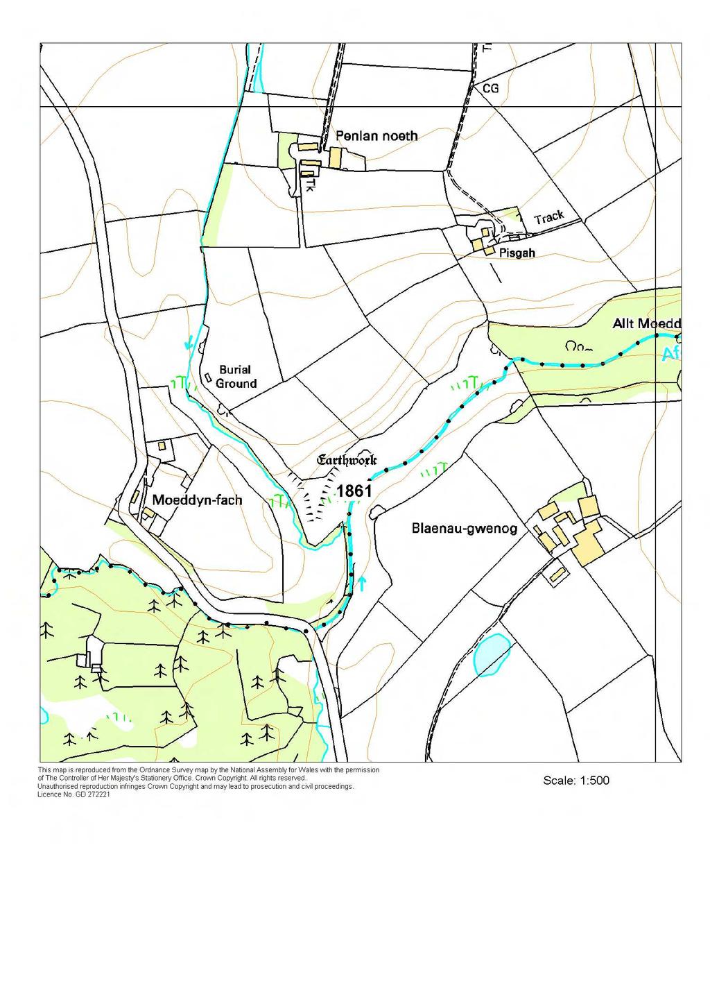
19 1861 CASTELL MOEDDYN FACH PRN 1861 NGR SN SITE NAME CASTELL MOEDDIN FACH SITE TYPE PROMONTORY FORT;CASTLE FORM Earthwork PERIOD Iron Age;Medieval CONDITION B SITE STATUS SAM DESCRIPTION Castell Moeddin Fach is a small inland promontory fort. A small triangular-shaped promontory with steep slopes on the west, south and east sides down to small streams is heavily defended by a bank and ditch on the north side. Overall this defence measures 35m long, 13m wide and about 2m high. There is a simple entrance about 4m wide in its centre. The interior area enclosed is very small, approximately 50m north - south and 25m east - west. It is probably an Iron Age fort, but King has listed it as a possible medieval castle site. The site is under bracken. K Murphy 15 December from various sources.

20 Aerial photograph Cambria Archaeology.
21
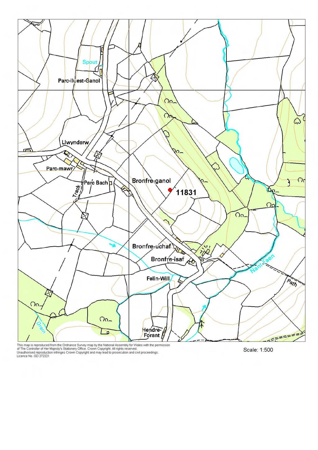
22 11831 BRONFRE-GANOL PRN NGR SN SITE NAME BRONFRE-GANOL SITE TYPE DEFENDED ENCLOSURE FORM Earthwork;Cropmark PERIOD Iron Age CONDITION D SITE STATUS DESCRIPTION Bronfre-ganol enclosure lies at the southeast end of a rounded hill at 130m above sea level. To the northwest through to the south and around to the west the land falls steeply away from the site. On the ground there is little trace of this site apart from a steep break of slope on the southeast side up to 1.5m high, now overlain by a hedge-bank, which may be part of a defensive circuit. Aerial photographs, however, show what seem to be a circular cropmark circular enclosure 110m diameter - the earthworks, above, forming the southeast side of the enclosure. The northwest side of the enclosure is defined by concentric cropmark ditches, closely spaced - about 10m apart. The location of the entrance is unknown. In 2005, the site was under improved pasture. K Murphy 25 May 2005


23 Aerial photograph Cambria Archaeology. Ground photograph looking at defence? on southeast side of site.
24
25 12280 PEN-Y-GAER PRN NGR SN SITE NAME PEN Y GAER;GAER RHYDLYDAN SITE TYPE DEFENDED ENCLOSURE FORM Earthwork PERIOD Iron Age CONDITION C SITE STATUS DESCRIPTION Aerial photographs show the bank of an oval earthwork enclosure on a rounded hill at 270m above sea level. To the south and east of the site the land falls steadily away to below 210m. To the northwest the land continues to rise gently to the summit of the rounded hill. The enclosure measures approximately 170m north - south and 110m east - west. An in-turned entrance lies on the southeast side. On the ground the earthwork is visible as a bank 12m - 15m wide and no more than 0.5m high. It is best preserved on the north side. There is no trace of a ditch. The east side of the entrance terminal is clearly visible, the west side less so, and there is no trace on the ground of the in-turned terminal visible on the aerial photographs. In 2005, the site was under improved pasture, but is occasionally ploughed. A few years ago the site owner (Rhydlydan Farm) reported that when ploughed the soil within north part of the enclosure was a different colour from that outside and within the rest of the enclosure. K Murphy 23 November 2005

26 Aerial photograph RCAHMW Crown Copyright reference 2001-cs Ground photograph showing slight earthworks of enclosure.
27
28 14244 PANTEG PRN NGR SN SITE NAME PANT-TEG SITE TYPE DEFENDED ENCLOSURE FORM Cropmark PERIOD Iron Age CONDITION D SITE STATUS DESCRIPTION Pant-teg is a cropmark enclosure lying on a small rounded local hilltop at 80m above sea level. To the north and east the land falls sharply away from the site. To the southwest the land falls gently away by a few metres into a saddle before climbing gently but steadily. The site is overlooked on this side. It is a concentric cropmark enclosure, with no clear earthwork or other surface evidence. On aerial photographs the inner enclosure is marked by a cropmark ditch, and is circular approximately 70m diameter, with a wide northeast facing entrance. A ditched track-way approaches the entrance up the steep slope from the northeast. The ditch on the east side of the track-way seems to curve out and form the ditch of the outer concentric enclosure, or 'banjo' enclosure. Only a short section of this concentric enclosure is visible on the east side, and perhaps a length on the northwest side, but if projected it would have a diameter of c. 170m. This outer enclosure runs around the slopes of the hill. In 2005, this site was examined from a public footpath. There was no surface evidence for the ditched track-way or the outer enclosure. Slight undulations may mark the inner ditch, but equally these may be geological. In 2005, the site was under improved pasture. K Murphy 25 May 2005
29 Aerial photograph RCAHMW Crown Copyright reference 2003-cs Ground photograph looking towards cropmark enclosure.

30
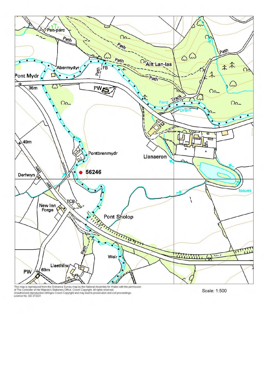
31 56246 LLANERCHAERON PRN NGR SN SITE NAME LLANERCHAERON ENCLOSURE SITE TYPE DEFENDED ENCLOSURE FORM Buried Feature PERIOD Iron Age;Roman CONDITION D SITE STATUS DESCRIPTION A geophysical survey undertaken by ArchaeoPhysica Ltd for the National Trust detected a defended enclosure. The enclosure is defined by a ditch - there is no trace of a bank. The enclosure is sub-rectangular, c. 60m north - south and 40m east west. The entrance lies towards the northern end of the west side. It is a simple gap, with a slight out-turn to the north ditch terminal. Towards the southwest corner of the site a circular anomaly c. 15m diameter probably marks the site of a roundhouse. The southwest corner of the site has been eroded by River Aeron. The site lies on the floodplain or a low terrace of the river - there are traces of old river channels in the vicinity of the site. K Murphy 3 March 2006
32
33
A SURVEY OF DEFENDED ENCLOSURES IN CEREDIGION, 2006: GAZETTEER OF ORDNANCE SURVEY GRID SQUARE SN35
 A SURVEY OF DEFENDED ENCLOSURES IN CEREDIGION, 2006: GAZETTEER OF ORDNANCE SURVEY GRID SQUARE SN35 Paratowyd gan Archaeoleg Cambria Ar gyfer Cadw Prepared by Cambria Archaeology ARCHAEOLEG CAMBRIA ARCHAEOLOGY
A SURVEY OF DEFENDED ENCLOSURES IN CEREDIGION, 2006: GAZETTEER OF ORDNANCE SURVEY GRID SQUARES SN14 AND SN15
 A SURVEY OF DEFENDED ENCLOSURES IN CEREDIGION, 2006: GAZETTEER OF ORDNANCE SURVEY GRID SQUARES SN14 AND SN15 Paratowyd gan Archaeoleg Cambria Ar gyfer Cadw Prepared by Cambria Archaeology ARCHAEOLEG CAMBRIA
SCHEDULING ENHANCEMENT PROJECT 2011: PREHISTORIC SITES FIELDWORK PEMBROKESHIRE ADDITIONAL SITES
 SCHEDULING ENHANCEMENT PROJECT 2011: PREHISTORIC SITES FIELDWORK PEMBROKESHIRE ADDITIONAL SITES Detail of balanced stones part of enclosure PRN 100702 situated on Banc Llwydlos, Mynydd Preseli, recorded
THE PEMBROKESHIRE CEMETERIES PROJECT
 THE PEMBROKESHIRE CEMETERIES PROJECT EXCAVATIONS AT ST BRIDES HAVEN, PEMBROKESHIRE 2009 DYFED ARCHAEOLOGICAL TRUST RHIF YR ADRODDIAD / REPORT NO. 2009/39 RHIF Y PROSIECT / PROJECT RECORD NO.94896 Mawrth
ARFORDIR COASTAL HERITAGE
 ARFORDIR COASTAL HERITAGE 2011-2012 Prepared by Dyfed Archaeological Trust For Cadw DYFED ARCHAEOLOGICAL TRUST RHIF YR ADRODDIAD / REPORT NO. 2012/24 RHIF Y DIGWYDDIAD/ PROJECT RECORD NO. 102763 WHITESANDS
Chiselbury Camp hillfort
 Chiselbury Camp hillfort Reasons for Designation Large univallate hillforts are defined as fortified enclosures of varying shape, ranging in size between 1ha and 10ha, located on hilltops and surrounded
Looking north from the SW shieling site with Lub na Luachrach in the foreground
 Looking north from the SW shieling site with Lub na Luachrach in the foreground Upper Gleann Goibhre - Shieling sites Two shieling sites in the upper reaches of the Allt Goibhre were visited and recorded
4. Bronze Age Ballybrowney, County Cork Eamonn Cotter
 4. Bronze Age Ballybrowney, County Cork Eamonn Cotter Illus. 1 Location map of the excavated features at Ballybrowney Lower (Archaeological Consultancy Services Ltd, based on the Ordnance Survey Ireland
The Atlas of Hillforts of Britain and Ireland. Hillfort survey notes for guidance
 The Atlas of Hillforts of Britain and Ireland Hillfort survey notes for guidance The collection of surveys for the Atlas is now finished but you can use this form and the accompanying Notes for Guidance
FOUNDATIONS OF ARCHAEOLOGY A WALK IN VERNDITCH CHASE
 FOUNDATIONS OF ARCHAEOLOGY A WALK IN VERNDITCH CHASE 1. A Tale of two Long Barrows Long barrows were constructed as earthen or drystone mounds with flanking ditches and acted as funerary monuments during
Baggy Point, Croyde, North Devon
 Baggy Point, Croyde, North Devon A walk using the South West Coast Path that is likely to be suitable for people with impaired mobility or with a pushchair, wheelchair, or mobility scooter. The Coast Path
Cholesbury New House, Parrots Lane, Cholesbury, Buckinghamshire
 Cholesbury New House, Parrots Lane, Cholesbury, Buckinghamshire An Archaeological Watching Brief For Mr Martin Wood by Sean Wallis Thames Valley Archaeological Services Ltd Site Code PLC 06/135 March 2007
Afon Adda Refurbishment Bangor
 Afon Adda Refurbishment Bangor Archaeological Assessment Revised Report GAT Project No. 1876 Report No. 628 April 2006 Ymddiriedolaeth Archaeolegol Gwynedd Gwynedd Archaeological Trust Craig Beuno, Ffordd
Pen Cerrig-calch prehistoric cairns
 Walk Information: Maps: OS Explorer OL13 Distance: 8 miles / 13 kilometres Duration: Allow at least 6 hours for the circular walk Difficulty: medium. Some narrow paths, occasionally rough underfoot Start
Nelson Mandela Community School, Colville Road, Sparkbrook, Birmingham, B12 8EH. Erection of single storey detached learning pod building
 Committee Date: 7/07/204 Application Number: 204/0362/PA Accepted: 22/05/204 Application Type: Full Planning Target Date: 7/07/204 Ward: Sparkbrook Nelson Mandela Community School, Colville Road, Sparkbrook,
Wheatlands House, Fleet Hill, Finchampstead, Berkshire
 Wheatlands House, Fleet Hill, Finchampstead, Berkshire An Archaeological Watching Brief For JCA International by James McNicoll-Norbury Thames Valley Archaeological Services Ltd Site Code WFF 08/26 August
CWMGIEDD FROM ABERCRAVE
 Abercrave to Cwmgiedd Walk Page 1 Starting from The Abercrave Inn. Grid Ref: SN 824128 From the Abercrave Inn, an 11.3km (7 miles) walk to the foothills of the Cribarth Mountain, then through forest to
BISHOPSTONE CIRCULAR WALK
 BISHOPSTONE CIRCULAR WALK 4½ miles (7¼ km) - allow 2 hours (see maps on final pages) Introduction This walk is within the North Wessex Downs Area of Outstanding Natural Beauty and starts from the small,
Following the initial soil strip archaeology is sprayed up prior to planning and excavation
 Barton Quarry & Archaeology Over the past half century quarries have been increasingly highlighted as important sources of information for geologists, palaeontologists and archaeologists, both through
6 Results of NMP mapping
 6 Results of NMP mapping 6.1 Overview of results In general terms the nature of archaeological evidence available from aerial photographs determines the types of site recorded as part of NMP. Usually these
11 Majors Barn. 19 Mill Street Exploring Abergavenny
 11 Majors Barn 19 Mill Street Exploring Abergavenny Cover: Mill Street from Monmouth Road 2 mill street EXPLORING ABERGAVENNY For several years the Abergavenny and District Civic Society has been studying
Unlocking Our Coastal Heritage Project: Crane Castle Promontory Fort, Illogan, Cornwall
 Unlocking Our Coastal Heritage Project: Crane Castle Promontory Fort, Illogan, Cornwall As part of a wider project funded by the Rural Development Programme for England (RDPE) and administered through
29 Plas Derwen. Exploring Abergavenny
 29 Plas Derwen Exploring Abergavenny Cover: rhythm 2 plas derwen EXPLORING ABERGAVENNY For several years the Abergavenny and District Civic Society has been studying the streets, spaces and buildings of
An Analytical Earthwork Survey of the Hillfort at Fin Cop, Derbyshire
 An Analytical Earthwork Survey of the Hillfort at Fin Cop, Derbyshire Aerial photograph of the scarp edge Hillfort at Fin Cop viewed from the north-west. ( English Heritage) ARS Ltd Report No. ARS/34 May
Excavations in a Medieval Market Town: Mountsorrel, Leicestershire,
 Excavations in a Medieval Market Town: Mountsorrel, Leicestershire, by John Lucas Mountsorrel is situated 12 kms north of Leicester and forms a linear settlement straddling the A6, Leicester to Derby road.
DEFENCE AREA 73 FRESHWATER BAY
 DEFENCE AREA 73 FRESHWATER BAY 1. Area details: The defence area is 3½ miles from The Needles and 10 miles W of Newport. County: Isle of Wight. Parish: Freshwater. NGR: centre of area, SZ 346860. 1.1 Area
A Possible Roman Road Discovered in Lanarkshire
 A Possible Roman Road Discovered in Lanarkshire In the eighteenth century, William Roy documented the Roman road network that provided communication between the Castledykes fort (near Carstairs, Lanarkshire)
32-36 Gildas Avenue, Kings Norton, Birmingham, B38 9HR. Application for prior notification of proposed demolition
 Committee Date: 08/08/2013 Application Number: 2013/05430/PA Accepted: 23/07/2013 Application Type: Demolition Determination Target Date: 20/08/2013 Ward: Kings Norton 32-36 Gildas Avenue, Kings Norton,
Grinton Mound East and Cogden Hall Swaledale North Yorkshire
 on behalf of Swaledale and Arkengarthdale Archaeology Group Grinton Mound East and Cogden Hall Swaledale North Yorkshire geophysical surveys report 2814 February 2012 Contents 1. Summary 1 2. Project background
Report on an archaeological watching brief at Thomas Lord Audley School, Monkwick, Colchester
 Report on an archaeological watching brief at Thomas Lord Audley School, Monkwick, Colchester July 2000 for WS Atkins Property Services Colchester Archaeological Trust 12 Lexden Road, Colchester, Essex
The Old Shire Horse Centre, Bath Road, Woolley Green, Maidenhead, Berkshire
 The Old Shire Horse Centre, Bath Road, Woolley Green, Maidenhead, Berkshire An Archaeological Watching Brief For Mr Derek Chesterman by Andrew Mundin Thames Valley Archaeological Services Ltd Site Code
Ystwyth and Rheidol Bridleway Routes. Route 2:Llanilar Circular
 Ystwyth and Rheidol Bridleway Routes Route 2:Llanilar Circular Route overview and terrain: A long circle using connecting ridges with fine views to link the Rheidol and Ystwyth river valleys. The route
Approximate distance: 4.5 miles For this walk we ve included OS grid references should you wish to use them. Start. End
 Approximate distance: 4.5 miles For this walk we ve included OS grid references should you wish to use them. 2 1 Start End 4 3 N W E S Reproduced by permission of Ordnance Survey on behalf of HMSO. Crown
A Circular Walk from Chapel Carn Brea
 A Circular Walk from Chapel Carn Brea 4.3 Miles A Walk Visiting Five Historic Ancient Sites This circular walk offers the possibility of several alternatives, depending on the walker s available time and
CHESHIRE HISTORIC TOWNS SURVEY
 CHESHIRE HISTORIC TOWNS SURVEY Eddisbury Archaeological Assessment 2003 CHESHIRE HISTORIC TOWNS SURVEY Eddisbury Archaeological Assessment 2003 Environmental Planning Cheshire County Council Backford Hall
7. Poverty Bay and East Coast
 7. Poverty Bay and East Coast The first fighting in the Poverty Bay and East Coast regions took place in 1865 at Tokomaru Bay, Waiapu and Hicks Bay, mostly between sections of the Ngāti Porou tribe (Cowan
MEDIEVAL AND EARLY POST-MEDIEVAL DEER PARKS
 MEDIEVAL AND EARLY POST-MEDIEVAL DEER PARKS A THREAT-RELATED ASSESSMENT 2015 Prepared by Dyfed Archaeological Trust For Cadw DYFED ARCHAEOLOGICAL TRUST DAT Event Record No. 107260 Report No. 2015/18 Cadw
Trail Summary. Defending Hope. Three Forts Time Travellers Trail (Hope Valley)
") 6hr Jump on a bus to explore the sites of three former defensive outposts in the Hope Valley. Navio Roman Fort has level access, whilst Mam Tor and Peveril Castle require a steep climb (hence there defensive
6hr Jump on a bus to explore the sites of three former defensive outposts in the Hope Valley. Navio Roman Fort has level access, whilst Mam Tor and Peveril Castle require a steep climb (hence there defensive
^ox, 7. Environment Agency. Hayling Island North Strategy *. M ^, v. * > -.
 ^ox, 7 Environment Agency Hayling Island North Strategy *. M ^, v. * > -. Consultation Document for Preferred Coastal Defence Options - Septem ber 2005 We are the Environment Agency. It s our job to look
Register of Parks and Gardens of Special Historic Interest in England. The first publicly owned park in Bradford, open in early 1850s.
 Register of Parks and Gardens of Special Historic Interest in England West Yorkshire Bradford Bradford Peel Park GD3330 II The first publicly owned park in Bradford, open in early 1850s. Historic Development
Radnorshire Historic Settlements: Earthwork Survey
 THE CLWYD POWYS ARCHAEOLOGICAL TRUST I., ; I./ "oh';;: Radnorshire Historic Settlements: Earthwork Survey 1995-6 ;--- - ~.'l:1 ';, CPAT Report No 169 CPAT Report No 169 Radnorshire Historic Settlements:
Henderson Mess, RAF Halton, Buckinghamshire
 Henderson Mess, RAF Halton, Buckinghamshire An archaeological watching brief for Stepnell Ltd by Stephen Hammond Thames Valley Archaeological Services Ltd Site Code RHA03/85 October 2003 Summary Site name:
Kelling to Lowestoft Ness Shoreline Management Plan. 6 Sites of Special Scientific Interest (SSSI)
") ECOM Kelling to Lowestoft Ness Shoreline Management Plan 6 Sites of Special Scientific Interest () 1 Weybourne Cliffs 2 Kelling Heath 3 Weybourne Town Pit 6.1 4 Beeston Cliffs 6.2 5 Sheringham and Beeston
ECOM Kelling to Lowestoft Ness Shoreline Management Plan 6 Sites of Special Scientific Interest () 1 Weybourne Cliffs 2 Kelling Heath 3 Weybourne Town Pit 6.1 4 Beeston Cliffs 6.2 5 Sheringham and Beeston
Land off Birdie Way, Rush Green, Hertford, Hertfordshire
 Land off Birdie Way, Rush Green, Hertford, Hertfordshire An Archaeological Evaluation for Bride Hall Development Limited by Sarah Coles Thames Valley Archaeological Services Site Code RGH00/ 01 January
TURNPIKE and PRE-TURNPIKE ROADS
 TURNPIKE and PRE-TURNPIKE ROADS Medieval and Early Post-Medieval Sites Scheduling Enhancement Project 2016 Prepared by Dyfed Archaeological Trust For Cadw DYFED ARCHAEOLOGICAL TRUST REPORT NO. 2016/61
DEFENCE AREA 52 SPEETON
 DEFENCE AREA 52 SPEETON 1. Area details: Speeton is 4½ miles S of Filey and 6 miles N of Bridlington. County: North Yorkshire. Parish: Reighton. NGR: centre of area, TA 147751. 1.1 Area Description: [see
Conservation Area Consent for demolition of existing building
 Committee Date: 19/09/2013 Application Number: 2013/02378/PA Accepted: 03/05/2013 Application Type: Conservation Area Target Date: 28/06/2013 Consent Ward: Ladywood 34 Carver Street, Jewellery Quarter,
Walton Basin. archaeology and conservation. Bill Britnell THE CLWYD-POWYS ARCHAEOLOGICAL TRUST
 Walton Basin archaeology and conservation Bill Britnell THE CLWYD-POWYS ARCHAEOLOGICAL TRUST Published with the help of grant aid from Cadw Welsh Government Contents Published by The Clwyd-Powys Archaeological
ANTONINE WALL - BARHILL
 Property in Care (PIC)no: PIC168 Designations: Scheduled Monument (SM90008) Taken into State care: 1960 (Guardianship) Last reviewed: 2005 HISTORIC ENVIRONMENT SCOTLAND STATEMENT OF SIGNIFICANCE ANTONINE
Hamilton School, Hamilton Road, Birmingham, B21 8AH
 Committee Date: 12/12/2013 Application Number: 2013/07822/PA Accepted: 17/10/2013 Application Type: Full Planning Target Date: 12/12/2013 Ward: Handsworth Wood Hamilton School, Hamilton Road, Birmingham,
Cadbury Hill. YCCCART Yatton, Congresbury, Claverham & Cleeve Archaeological Research Team
 YCCCART Yatton, Congresbury, Claverham & Cleeve Archaeological Research Team How old is it? Cadbury Hill The hill top of Cadbury-Congresbury has produced signs of activity in Neolithic and Bronze Age times
Approximate distance: 5.5 miles For this walk we ve included OS grid references should you wish to use them. Start. End
 Approximate distance: 5.5 miles For this walk we ve included OS grid references should you wish to use them. Start End 2 1 5 4 6 3 N W E 7 S Reproduced by permission of Ordnance Survey on behalf of HMSO.
archeological site LOS MILLARES
 archeological site LOS MILLARES Aerial view of the plain of Los Millares between the Rambla de Huéchar and the River Andarax The archaeological site of Los Millares is located in the township of Santa
ARCHAEOLOGICAL SITE SURVEY ON PONUI ISLAND, HAURAKI GULF, NEW ZEALAND. by Peter J. Matthews SUMMARY
 TANK 25, 1979 ARCHAEOLOGICAL SITE SURVEY ON PONUI ISLAND, HAURAKI GULF, NEW ZEALAND by Peter J. Matthews 3 Sadgrove Terrace, Mount Albert, Auckland 3 SUMMARY Thirty four archaeological sites were recorded
Wicklow Mountains Path Survey
 Wicklow Mountains Path Survey Glenmacnass Tonelagee Start to Finish: O 114 030 to O 085 016 Altitude (lowest highest): 370m 817m Weather: Sunny day, hot Access: Military Road, Glenmacnass Surveyed by:
Archaeological Watching Brief on land at Alpha, Gore Road, Eastry, Kent July 2010
 Archaeological Watching Brief on land at Alpha, Gore Road, Eastry, Kent July 2010 SWAT. Archaeology Swale and Thames Archaeological Survey Company School Farm Oast, Graveney Road Faversham, Kent ME13 8UP
In September, 1966, an
 ANNE S. ROBERTSON, D LITT THE ROMAN CAMP(S) ON HILLSIDE FARM, DUNBLANE, PERTHSHIRE This paper is published with the aid of a grantfrom H.M.Treasury In September, 1966, an emergency excavation was begun,
Gors Lydan barrows and medieval huts
 Walk Information: Maps: OS Explorer 214 Distance: 5.5 miles / 9 kilometres Duration: 4.5 to 5 hours Difficulty: Easy. Good paths and no steep gradients Start and finish: SO 11977545 Walk summary The walk
Introduction to Map 30: Sgeir Alt Mhic Eoghainn to Ton Loisgte
 Introduction to : Sgeir Alt Mhic Eoghainn to Ton Loisgte This map section covers some 7.8km of coastline. This section takes in the south western facing butt of the Rhinns and includes the villages of
DONCASTER BOROUGH COUNCIL (VARIOUS ROADS, DONCASTER) (MOVING TRAFFIC) (CONSOLIDATION) ORDER 2009 (AMENDMENT NO. ) ORDER 2018
 (MOVING TRAFFIC) (CONSOLIDATION) ORDER 2009 (AMENDMENT NO. ) ORDER 2018") DONCASTER BOROUGH COUNCIL (VARIOUS ROADS, DONCASTER) (MOVING TRAFFIC) (CONSOLIDATION) ORDER 009 (AMENDMENT NO. ) ORDER 08 Doncaster Borough Council ( the Council ) in exercise of its powers under Sections,
DONCASTER BOROUGH COUNCIL (VARIOUS ROADS, DONCASTER) (MOVING TRAFFIC) (CONSOLIDATION) ORDER 009 (AMENDMENT NO. ) ORDER 08 Doncaster Borough Council ( the Council ) in exercise of its powers under Sections,
Holyport Manor Special School, Highfield Lane, Cox Green, Maidenhead, Berkshire
 Holyport Manor Special School, Highfield Lane, Cox Green, Maidenhead, Berkshire An Archaeological recording action For CgMs Consulting by Jennifer Lowe Thames Valley Archaeological Services Ltd Site Code
BUSINESS UNIT FOR SALE/MIGHT LEASE St Ives, Cambridgeshire
 BUSINESS UNIT FOR SALE/MIGHT LEASE St Ives, Cambridgeshire 01480 451578 ww.b Unit A Lakes Business Park, St Ives, Cambridgeshire, PE28 9QR Price: 700,000 plus VAT Size: 648 sq m (6,975 sq ft) New light
2 The Monuments and Their Setting by Mark Corney and Andrew Payne
 2 The Monuments and Their Setting by Mark Corney and Andrew Payne The sites examined provide a representative regional sample of those sites traditionally classified as hillforts in the Wessex region.
M54 to M6/M6 Toll Link Road Public consultation
 to M6/M6 Toll Link Road Public consultation 15 September 2017 to 13 October 2017 Contents Introduction 4 5 Why do we need this scheme? 6 Previous consultation 7 8 Modified options 9 Option B West 10 Option
CASTLE OF OLD WICK HISTORIC ENVIRONMENT SCOTLAND STATEMENT OF SIGNIFICANCE. Property in Care(PIC) ID: PIC282 Designations:
 ID: PIC282 Designations:") Property in Care(PIC) ID: PIC282 Designations: Scheduled Monument (SM90065) Taken into State care: 1957 (Guardianship) Last reviewed: 2004 HISTORIC ENVIRONMENT SCOTLAND STATEMENT OF SIGNIFICANCE CASTLE
Property in Care(PIC) ID: PIC282 Designations: Scheduled Monument (SM90065) Taken into State care: 1957 (Guardianship) Last reviewed: 2004 HISTORIC ENVIRONMENT SCOTLAND STATEMENT OF SIGNIFICANCE CASTLE
Hunsbury Hill, Northampton, Northants
 Hunsbury Hill, Northampton, Northants The Atlas of Hillforts of Britain and Ireland Hillfort survey (v2 October 2013) Important information: This form must be used with the accompanying Notes for Guidance
Survey of Littleton Down
 Survey of Littleton Down 05 November 2014 The Team: John and Jenny Barnard 1) Introduction Littleton Down (Hill Number 2911, Section 42, OS 1:50000 Map 197, OS 1:25000 Map 121, Grid Ref. SU941150) is listed
Morning Copse near Maidstone, Kent acres of Ancient Woodland with a pond, bluebells and mature oak. 26,500 (freehold)
") WOODS 4 SALE Phone: 01248 364 362 www.woods4sale.co.uk UK Woodland & Woods For Sale: Specialising in the Sales of Small Woodlands in England, Scotland and Wales for Recreation, Wildlife Conservation and
WOODS 4 SALE Phone: 01248 364 362 www.woods4sale.co.uk UK Woodland & Woods For Sale: Specialising in the Sales of Small Woodlands in England, Scotland and Wales for Recreation, Wildlife Conservation and
Eglwyseg Mountain a landscape of prehistoric cairns and later industry
 Eglwyseg Mountain a landscape of prehistoric cairns and later industry Walk Information: Maps: OS Explorer 256 Distance: 5.3 miles / 8.5 kilometres (linear) or up to 9.6 miles / 15.5 kilometres (circular)
Scheduled Monument (SM90085) Taken into State care: 1966 (Guardianship) Last reviewed: 2004 CROOKSTON CASTLE
 Taken into State care: 1966 (Guardianship) Last reviewed: 2004 CROOKSTON CASTLE") Property in Care (PIC) ID: PIC119 Designations: Scheduled Monument (SM90085) Taken into State care: 1966 (Guardianship) Last reviewed: 2004 HISTORIC ENVIRONMENT SCOTLAND STATEMENT OF SIGNIFICANCE CROOKSTON
Property in Care (PIC) ID: PIC119 Designations: Scheduled Monument (SM90085) Taken into State care: 1966 (Guardianship) Last reviewed: 2004 HISTORIC ENVIRONMENT SCOTLAND STATEMENT OF SIGNIFICANCE CROOKSTON
Wicklow Mountains Path Survey
 Wicklow Mountains Path Survey Ballinacor Croaghanmoira Fananierin Start to Finish: T 11723 86602 to T 11175 89057 Altitude (lowest highest): 385m 664m Weather: Hot Access: Coolgarrow forest entrance Surveyed
Bewl Water & the High Weald
 1 Bewl Water & the High Weald Stonegate station - Stonegate - Wallcrouch - Newbarn - Cousley Wood - Wood's Green - Wadhurst station Length: 9 ½ miles (15.3km) Underfoot: Large portions of this path are
Tesco Express, Alcester Road South, Kings Heath, Birmingham, B14 6EB
 Committee Date: 27/11/2014 Application Number: 2014/06477/PA Accepted: 09/09/2014 Application Type: Variation of Condition Target Date: 09/12/2014 Ward: Brandwood Tesco Express, 281-289 Alcester Road South,
Excavations South-East of Park Farm, Ashford, Kent. Part 1: Main Report
 Excavations South-East of Park Farm, Ashford, Kent Part 1: Main Report Wessex Archaeology, Portway House, Old Sarum Park, Salisbury SP4 6EB tel: 01722 326867 fax: 01722 337562 email: info@wessexarch.co.uk
HILLFORT STUDY GROUP HILLFORTS IN DORSET A GUIDE TO THE SITES VISITED DURING THE INAUGURAL CONFERENCE AT DORCHESTER, DORSET APRIL 29 - MAY
 HILLFORT STUDY GROUP HILLFORTS IN DORSET A GUIDE TO THE SITES VISITED DURING THE INAUGURAL CONFERENCE AT DORCHESTER, DORSET APRIL 29 - MAY 1 1966 Chalbury (after C. Warne Ancient Dorset, (1872), Plate
Downton, Wiltshire: archaeology and history (notes for visitors prepared by the Royal Archaeological Institute, 2017)
") Downton, Wiltshire: archaeology and history (notes for visitors prepared by the Royal Archaeological Institute, 2017) The River Avon leaves Wiltshire in Downton, a large parish that includes parts of the
Downton, Wiltshire: archaeology and history (notes for visitors prepared by the Royal Archaeological Institute, 2017) The River Avon leaves Wiltshire in Downton, a large parish that includes parts of the
Remote Sensing into the Study of Ancient Beiting City in North-Western China
 Dingwall, L., S. Exon, V. Gaffney, S. Laflin and M. van Leusen (eds.) 1999. Archaeology in the Age of the Internet. CAA97. Computer Applications and Quantitative Methods in Archaeology. Proceedings of
S E R V I C E S. Land to the rear of Ashdown, Basingstoke Road, Spencers Wood, Reading, Berkshire. Archaeological Evaluation.
 T H A M E S V A L L E Y ARCHAEOLOGICAL S E R V I C E S Land to the rear of Ashdown, Basingstoke Road, Spencers Wood, Reading, Berkshire Archaeological Evaluation by Susan Porter Site Code: ASW12/21 (SU
St. Clements C of E Academy, Butlin Street, Birmingham, B7 5NS. Installation of multi-use games area and associated access works.
 Committee Date: 12/06/2014 Application Number: 2014/02723/PA Accepted: 22/04/2014 Application Type: Full Planning Target Date: 17/06/2014 Ward: Nechells St. Clements C of E Academy, Butlin Street, Birmingham,
An Assessment of Lower Boddington
 W An Assessment of Lower Boddington Design and Conservation Team Reviewed Winter 2017 Contents Introduction... 2 Origins and Archaeology... 3 Historic Development... 3 Plan Form... 3 Space and relationship
ARCHAEOLOGICAL DESKTOP ASSESSMENT
 Rose Energy ARCHAEOLOGICAL DESKTOP ASSESSMENT In relation to a proposed Biomass Fuelled Power Plant At Land off Ballyvannon Road, Nr Glenavy, County Antrim 2 ROSE ENERGY PROJECT, GLENAVY CO. ANTRIM ARCHAEOLOGICAL
From the car park go through the wooden gate and walk to a large information board and wooden totem pole ahead of you.
 Trail Dave Price, Geograph (CCL) Twin peaks What are these striking wooded hills here in an otherwise flat landscape? Time: 40-60 mins Distance: 1 ¼ miles Landscape: rural Standing at over 300 feet tall
Swallow House, 10 Swallow Street, Birmingham, B1 1BD
 Committee Date: 20/02/2014 Application Number: 2013/08477/PA Accepted: 29/11/2013 Application Type: Full Planning Target Date: 28/02/2014 Ward: Ladywood Swallow House, 10 Swallow Street, Birmingham, B1
Lakes Business Park, St Ives, Cambridgeshire, PE28 9QR
 WAREHOUSE/PRODUCTION/ OFFICE BUILDINGS FOR SALE/TO LET St Ives, Cambridgeshire 01480 451578 ww.b Lakes Business Park, St Ives, Cambridgeshire, PE28 9QR Rent/Price: Upon application Size: building options
Residential Development Opportunity with Planning Permission in Principle
 Residential Development Opportunity with Planning Permission in Principle Land at Fardalehill, B7081/Irvine Road, Kilmarnock, East Ayrshire KA1 2LA A Development By Location The site is located in Kilmarnock,
DEFENCE AREA 53 ATWICK
 DEFENCE AREA 53 ATWICK 1. Area details: Atwick is 2 miles N of Hornsea, with Beverley 12 miles to the SW. County: East Riding of Yorkshire. Parish: Atwick NGR: centre of area, TA 196510. 1.1 Area Description:
Just under a mile from Cawfields car park where the walk begins is Great Chesters Roman Fort. It is behind the tree, looking from the west.
 Tynedale U3A Hadrian s Wall Group Cawfields to Birdoswald Just under a mile from Cawfields car park where the walk begins is Great Chesters Roman Fort. It is behind the tree, looking from the west. Great
For Sale shott HoUse and development land with detailed planning Consent for four detached villas Hamilton Road, HigH BlantyRe, glasgow g72 9Ud
 For Sale Shott House and Development Land with Detailed Planning Consent for Four Detached Villas Hamilton Road, High Blantyre, Glasgow G72 9UD The Opportunity Savills are delighted to bring to the market
The Tel Burna Archaeological Project Report on the First Season of Excavation, 2010
 The Tel Burna Archaeological Project Report on the First Season of Excavation, 2010 By Itzick Shai and Joe Uziel Albright Institute for Archaeological Research Jerusalem, Israel April 2011 The site of
MONTEVECCHIA Pyramid Hills.. Summary 9 pages
 Gabriela Lukacs, Mag.rer.soc.oec., graduate Vienna university Post graduate art +history university Siena, Italy Participant of the excavations in Visoko, Bosnia since 2006 Grinzinger Allee 15, 1190 Wien,
Brenig Archaeology Trail
 Walk Information: Maps: OS Explorer 264 Distance: 2.5 miles / 4 kilometres Duration: Allow 2.5 hours for the circular walk Difficulty: easy. Well-marked trail over fields. Start and finish: SH 98325741
Minutes of Trawsgoed Community Council held at Llanfihangel-y-Creuddyn School on Monday 20th February, 2017 at 7.30 p.m.
 601 Minutes of Trawsgoed Community Council held at Llanfihangel-y-Creuddyn School on Monday 20th February, 2017 at 7.30 p.m. Present: Cllr. Sh. Edwards (Chairman) Cllr. T.A.G. Davies Cllr. H.M. Evans Cllr.
Open Report on behalf of Richard Wills Executive Director for Communities. Planning and Regulation Committee. County Matter Application - S38/0590/13
 Agenda Item 5.10 Report Reference: 5.10 Regulatory and Other Committee Open Report on behalf of Richard Wills Executive Director for Communities Report to: Planning and Regulation Committee Date: 10 June
An archaeological excavation and watching brief at the Musket Club, Homefield Road, Colchester, Essex December 2004-February 2005
 An archaeological excavation and watching brief at the Musket Club, Homefield Road, Colchester, Essex December 2004-February 2005 report prepared by Howard Brooks on behalf of RMPA and the MoD CAT project
Clwyd Powys Archaeological Trust Historic Settlement Survey - Montgomeryshire
 Montgomery SO 0223 9652 15740 Introduction The town of Montgomery is approximately equidistant from two of the major towns of mid- Wales, Newtown and Welshpool, the former lying about 10km to the west-south-west,
14 Holywell Exploring Abergavenny
 14 Holywell Exploring Abergavenny Cover: In a 1930s style, but post 1945? 2 holywell EXPLORING ABERGAVENNY For several years the Abergavenny and District Civic Society has been studying the streets, spaces
3 Archaeological Landscapes
 3 Archaeological Landscapes Pg 9-26 3. Archaeological Landscapes 1.Tiduff/Glenderry (Kerry Head) Promontory Forts, Hillfort/Hilltop Enclosure, Linear Earthwork (Red Ditch). The monuments located in this
CASTLELAW HILL FORT HISTORIC ENVIRONMENT SCOTLAND STATEMENT OF SIGNIFICANCE. Property in Care (PIC) ID: PIC131
 ID: PIC131") Property in Care (PIC) ID: PIC131 Designations: Scheduled Monument (SM90064) Taken into State care: 1933 (Guardianship) Last reviewed: 2012 HISTORIC ENVIRONMENT SCOTLAND STATEMENT OF SIGNIFICANCE CASTLELAW
Property in Care (PIC) ID: PIC131 Designations: Scheduled Monument (SM90064) Taken into State care: 1933 (Guardianship) Last reviewed: 2012 HISTORIC ENVIRONMENT SCOTLAND STATEMENT OF SIGNIFICANCE CASTLELAW
Walk 1: Highfield, Lob Wood and The River Wharfe
 Walk 1: Highfield, Lob Wood and The River Wharfe Start: The Hen Pen Garden, Main Street, Addingham LS29 0NS, SE 077 498. Alternative Start: Near Bolton Bridge SE 071 525 (see page 6). Full walk: 4.5 miles
Reservoir Tin workings
 The workings are quite over-grown and covered in moss, suggesting that they date to the earliest period of mining. This is supported by the fact that their head race was cut off by the reservoir (D49/47)