A SURVEY OF DEFENDED ENCLOSURES IN CEREDIGION, 2006: GAZETTEER OF ORDNANCE SURVEY GRID SQUARE SN35
|
|
|
- Amanda Lindsey
- 5 years ago
- Views:
Transcription

1 A SURVEY OF DEFENDED ENCLOSURES IN CEREDIGION, 2006: GAZETTEER OF ORDNANCE SURVEY GRID SQUARE SN35 Paratowyd gan Archaeoleg Cambria Ar gyfer Cadw Prepared by Cambria Archaeology


2 ARCHAEOLEG CAMBRIA ARCHAEOLOGY RHIF YR ADRODDIAD / REPORT NO. 2006/20 RHIF Y PROSIECT / PROJECT RECORD NO Mawrth 2006 March 2006 A SURVEY OF DEFENDED ENCLOSURES IN CEREDIGION, 2006: GAZETTEER OF ORDNANCE SURVEY GRID SQUARE SN35 Gan / By K Murphy, R Ramsey and M Page Archaeoleg Cambria yw enw marchnata Ymddiriedolaeth Archaeolegol Dyfed Cyfyngedig. Cambria Archaeology is the marketing name of the Dyfed Archaeological Trust Limited. Paratowyd yr adroddiad yma at ddefnydd y cwsmer yn unig. Ni dderbynnir cyfrifoldeb gan Archaeoleg Cambria am ei ddefnyddio gan unrhyw berson na phersonau eraill a fydd yn ei ddarllen neu ddibynnu ar y gwybodaeth y mae n ei gynnwys The report has been prepared for the specific use of the client. Cambria Archaeology can accept no responsibility for its use by any other person or persons who may read it or rely on the information it contains. ARCHAEOLEG CAMBRIA Ymddiriedolaeth Archaeolegol Dyfed Cyf Neuadd y Sir, Stryd Caerfyrddin, Llandeilo, Sir Gaerfyrddin SA19 6AF Ffon: Ymholiadau Cyffredinol Adran Rheoli Treftadaeth Ffacs: Ebost: cambria@acadat.com Gwefan: CAMBRIA ARCHAEOLOGY Dyfed Archaeological Trust Limited The Shire Hall, Carmarthen Street, Llandeilo, Carmarthenshire SA19 6AF Tel: General Enquiries Heritage Management Section Fax: cambria@acadat.com Website: Cover: Aerial photograph of Gaerwen. RCAHMW Crown Copyright reference 95-cs-2060

3 SITE GAZETTEER OF 10KM GRID SQUARE SN35 For ease of handing the site gazetteers have been arranged into Ordnance Survey 10km grid squares. Each gazetteer consists of one or more 1:50,000 maps showing the overall location of each site followed by the individual entries for each site. Each entry comprises: a printout from the Historic Environment Record, including a site description; a 1:500 map; and where available a ground photograph and an aerial photograph. Many of the 1;500 maps show details of the site plotted from cropmarks shown on aerial photographs. These plots are supplied by RCAHMW Crown Copyright. Index to the gazetteers of defended enclosures and related sites. Gazetteers are arranged by 10km grid squares.

4 1:50,000 Distribution map of sites in 10km grid square SN35. This map is reproduced from the Ordnance Survey map by the National Assembly for Wales with the permission of The Controller of Her Majesty's Stationery Office. Crown Copyright. All rights reserved. Unauthorised reproduction infringes Crown Copyright and may lead to prosecution and civil proceedings. Licence No. GD
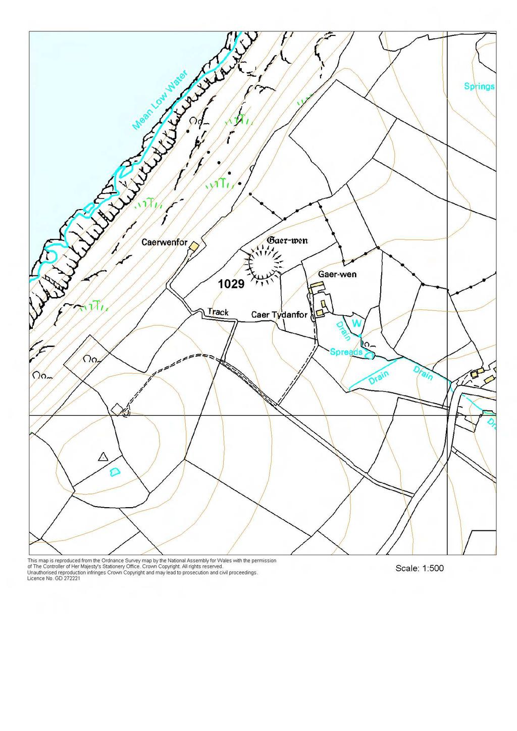
5 1029 GAER-WEN PRN 1029 NGR SN SITE NAME GAER-WEN;GARN WEN SITE TYPE DEFENDED ENCLOSURE FORM Earthwork PERIOD Iron Age CONDITION C SITE STATUS SAM;ACK DESCRIPTION Gaer-wen is a small, sub-circular defended enclosure located at 180m above sea level on a gentle southeast-facing slope. To the northeast of the site for c. 80m the land continues to rise for several metres before falling away sharply to the sea. The site is defined by a low bank, up to 1.2m high. This is topped by a ruinous field wall on the southern side. There is no obvious ditch or entrance on the ground, but aerial photographs show lush grass growth over a ditch on the north side and a clear southeast-facing entrance through the bank. The enclosure measures approximately 60m diameter internally, and approximately 90m externally. A circular hollow with a drainage hood over it in the southern part of the site may be the site of a round-house. The site is under rough pasture with some bracken growth and scrub on sections of the bank. K Murphy 14 December From Cadw and Ordnance Survey descriptions.
6 Aerial photograph RCAHMW Crown Copyright reference 95-cs-2060.
7
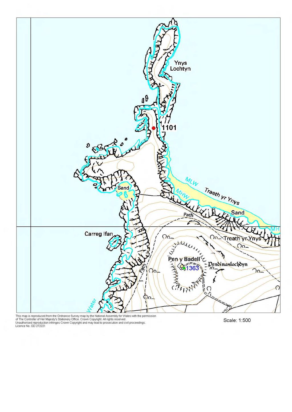
8 1101 YNYSLOCHDIN PRN 1101 NGR SN SITE NAME SITE TYPE YNYSLOCHDIN PROMONTORY FORT FORM Earthwork PERIOD Iron Age CONDITION C SITE STATUS DESCRIPTION Ynyslochdin is a superbly naturally defended small coastal promontory fort. On three sides vertical sea cliffs provide the defence. A bank and ditch protect the easily approachable south side. This rampart has been constructed across the narrowest point of the promontory. It is approximately 18m long, 12m wide and 1m high, with a slight external (south side) depression marking the line of a silted ditch. A lower level in the centre of the bank marks the entrance. A circular hollow 3m diameter on the east end of the bank may mark the site of a WW2 installation, or some other recent disturbance. The bank defends a promontory approximately 80m by 50m. A very slight bank running along part of the cliff edge on the east side may be part of the defensive circuit, but is perhaps more likely to be an old field bank, now mostly fallen into the sea. Two or three very slight circular terraces within the interior may mark the site of round-houses. Immediately to the north of the fort is the island itself of Ynyslochdin. This was not accessed in 2005, but more hollows on this island may mark the site of more houses. It is unknown whether the island formed part of the promontory at the time of the fort's use and has subsequently separated into an island. The site is under grass and grazed. K Murphy 9 June 2005

9 Aerial photograph RCAHMW Crown Copyright reference 99-cs-2281 Ground photograph looking at defensive bank from exterior of fort.
10
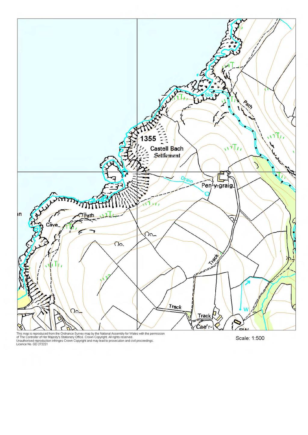
11 1355 CASTELL BACH PRN 1355 NGR SN SITE NAME SITE TYPE CASTELL BACH PROMONTORY FORT FORM Earthwork PERIOD Iron Age CONDITION B SITE STATUS SAM DESCRIPTION Castell Bach is a bivallate coastal promontory fort with a concentric annexe lying just 20m above the sea, naturally defended to the north and west by sea cliffs. Two sets of curving bank and ditch c. 90m long defend the easily approachable east/northeast side and enclose an area of about 0.3ha. There is no obvious entrance. A second slighter defensive bank with evidence of a stone revetment lies approximately 100m to the east, and extends from a natural scarp to the sea cliffs. The interior of Castell Bach is overlooked from the scarp. A survey by K Ray indicated that the inner enclosure originally had just one bank and ditch, and that the second was added at the same time as the outer defence. The site is under pasture. K Murphy 14 December from Cadw and Ordnance Survey descriptions.

12 Aerial photograph Cambria Archaeology
13
14 1357 CASTELL ABER-DEUDDWR PRN 1357 NGR SN SITE NAME SITE TYPE CASTELL ABER-DEUDDWR DEFENDED ENCLOSURE;CASTLE? FORM Earthwork PERIOD Iron Age?;Roman?;Early Medieval?;Medieval CONDITION B SITE STATUS SAM DESCRIPTION Castell Aber-deuddwr is a rectangular defended enclosure lying on a west-facing slope at 140m above sea level. A bank up to 1.6m high with an external rock-cut ditch 1.2m deep and a slight counterscarp bank surround it. There is a simple entrance in the southeast corner. Internally the enclosure measures 70m north - south and 55m east - west. The internal area is featureless and under improved pasture. The bank and ditch is scrub covered. It has been suggested that this was Caerwedros, the centre of the commote of the same name. K Murphy 14 December from Cadw and Ordnance Survey descriptions.

15 Aerial photograph Cambria Archaeology

16
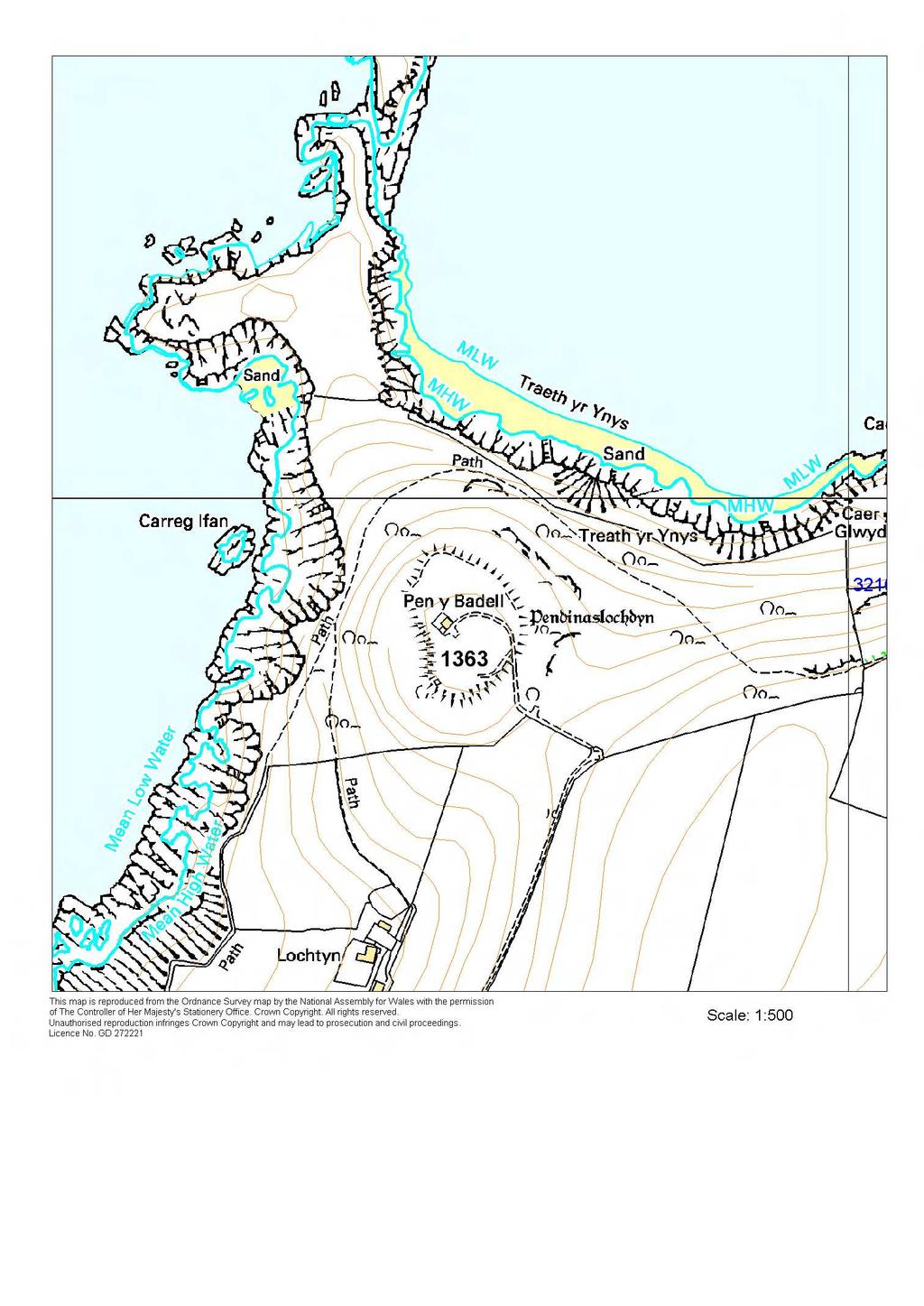
17 1363 PENDINASLOCHDIN PRN 1363 NGR SN SITE NAME PENDINASLOCHDIN SITE TYPE HILLFORT FORM Earthwork PERIOD Iron Age:Bronze Age;Roman CONDITION C SITE STATUS SAM;ACK DESCRIPTION Pendinaslochdin lies in a superb naturally defensive location on the summit of a steep sided hill at 150m above sea level. It commands wide-ranging views inland and over Cardigan Bay. The hillfort is irregular in shape and c. 1.4ha in extent. The defensive circuit of the hillfort makes full use of the steep break of slope. On the north and east sides, where the hill is at its steepest and includes low cliffs, a bank 5m wide and up to 5m high is evident - really this is just a scarping of the slope with no evidence of a ditch. On the south side the bank is more substantial with an external ditch, while to the southeast the defences become almost bivallate with a bank, ditch and bank. The entrance must lie on the southeast side, but it is unclear whether it is under a modern track-way entrance or further to the south. A MoD installation lies at the highest point of the sloping interior. Several hollows in the interior may be sites of round-houses. An excavation during construction of the MoD installation revealed a possible round-house and four-post structure. A Bronze Age radiocarbon date came from a post-hole and a Romano-British date from the round-house. The site is under rough pasture. K Murphy 14 December 2005


18 Aerial photograph Cambria Archaeology. Ground photograph - distant view of the hillfort.
19
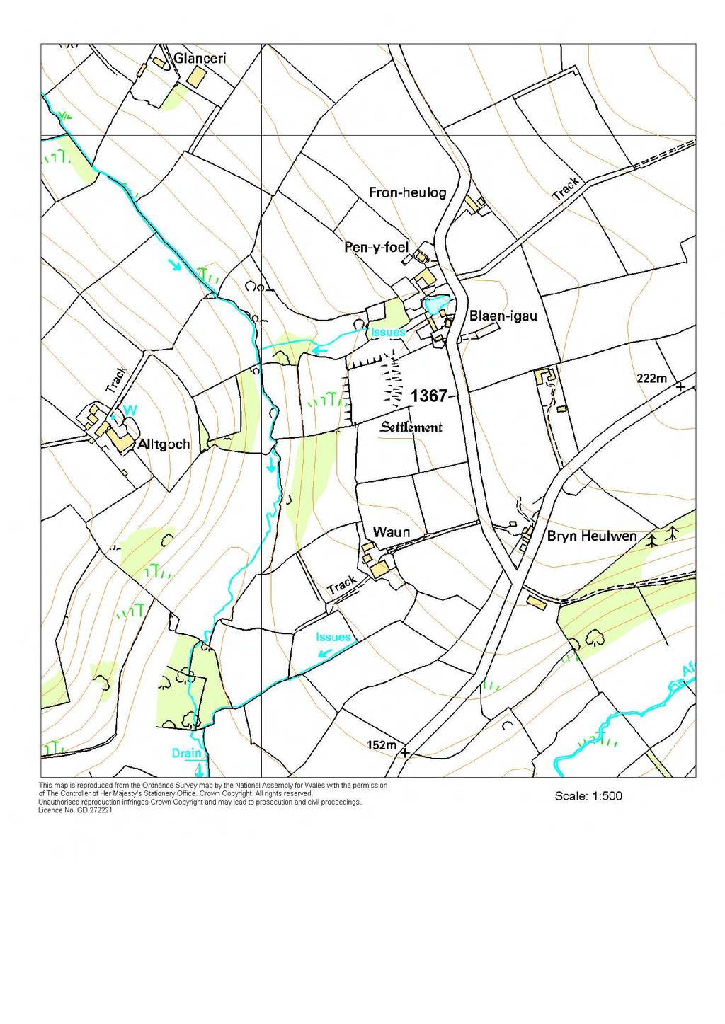
20 1367 CASTELL BLAEN-IGAU PRN 1367 NGR SN SITE NAME CASTELL BLAEN-IGAU SITE TYPE PROMONTORY FORT FORM Earthwork PERIOD Iron Age CONDITION C SITE STATUS SAM DESCRIPTION Castell Blaen-igau is an inland promontory fort lying at 190m above sea level naturally defended by steep slopes to the north and west. A substantial curving bank defends the east and south sides; this defines a sub-rectangular internal area of c. 0.4ha. The bank rises up to 2.5m from the interior of the fort, and is 3m - 4m above the bottom of the ditch. These defences are best preserved on the east, and fade to the south, dwindling to nothing on the southwest. On the north and west side the there is scarping of the natural steep slope. There is no obvious entrance. The interior is under improved pasture and the banks are covered in scrub. K Murphy 14 December from Cadw and Ordnance Survey descriptions.

21 Aerial photograph Cambria Archaeology
22
23 1368 CASTELL BACH PRN 1368 NGR SN SITE NAME SITE TYPE CASTELL-BACH PROMONTORY FORT FORM Earthwork PERIOD Iron Age CONDITION C SITE STATUS SAM DESCRIPTION Castell-bach is a coastal promontory fort at 100m above sea level. On the north and west sides the land falls steeply away to the sea, and on the south side to a stream, providing natural defences. The promontory on the east side is cut off by a single bank and ditch, giving a roughly rectangular internal area of 0.67 ha. The bank is 1.5m - 2m high internally and rises 2.5m above the bottom of the ditch. The ditch is 0.8m deep and 3m wide. A break mid-way along the bank probably indicates the site of the entrance, but is now used by farm vehicles. The interior is under improved pasture and the defences and steep slopes under scrub. K Murphy 14 December taken from Cadw and other descriptions.

24 Aerial photograph Cambria Archaeology

25
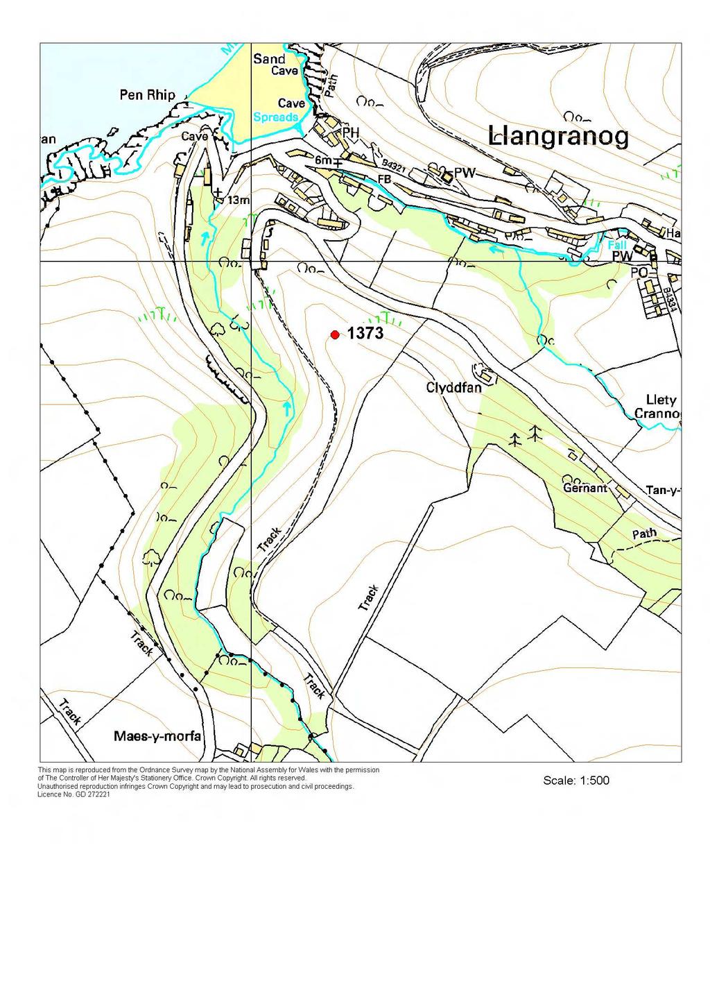
26 1373 LLANGRANNOG PRN 1373 NGR SN SITE NAME SITE TYPE LLANGRANOG PROMONTORY FORT FORM Earthwork PERIOD Iron Age CONDITION C SITE STATUS DESCRIPTION This fort is located on rocky inland promontory, at 90m above sea level, overlooking the sea. It is a good naturally defended site; to the southwest and northeast the land falls away almost vertically. To the northwest, down the nose of the promontory, the fall is more gentle, but still steep, while to the southeast the promontory is separated from a plateau of farmland by a natural saddle 70m wide and 8m deep. The face of this saddle on the promontory side is steep and rocky, and has the impression of being artificially fashioned into a defensive element, but this is not the case. The top of the promontory slopes down in a series of rocky steps from southeast to northwest, and is gorse and bracken covered, which hinders the identification of archaeological remains. Nevertheless, some 30m northwest of the rocky face of the saddle mentioned above, a bank c. 5m wide and 0.8m high with a ditch on its southeast side and counterscarp bank southeast of the ditch runs southwest -northeast across the promontory. These earthworks stop short of the steep slope on the northeast side, perhaps indicating the site of an entrance. Approximately 70m northwest of these earthworks a rocky bank runs across the promontory southwest -northeast. On first appearance this could be a defence against those trying to enter the fort from northwest, but it is more likely that it is an entirely natural feature. Some of the steep slopes on the edge of the fort have been quarried for stone in the past, but this activity does not seem to have damaged the fort. K Murphy 17 November 2005

27 Ground photograph showing earthwork defences.
28
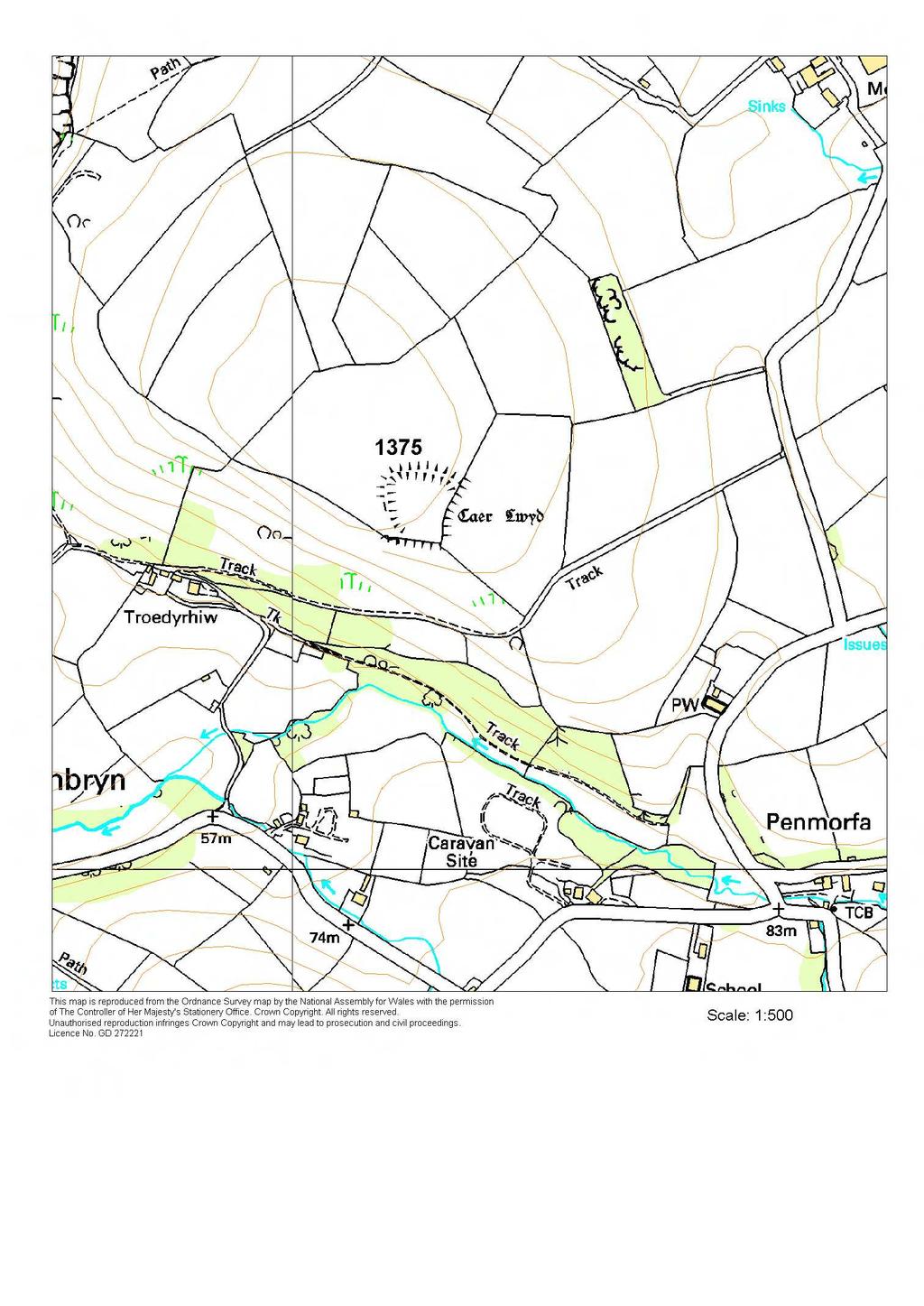
29 1375 GAER LLWYD PRN 1375 NGR SN SITE NAME GAER LWYD SITE TYPE DEFENDED ENCLOSURE FORM Earthwork PERIOD Iron Age CONDITION C SITE STATUS DESCRIPTION Gaer Lwyd is a defended enclosure located on gently sloping ground on a scarp edge at 150m above sea level, just off the highest point of a rounded hill. It is overlooked. The steep scarp slope that falls away by over 80m forms the defence to the south side of the site. A very spread defensive bank forms the defence to the west and north. This bank is up to 15m wide and 0.7m high. A depression outside the bank marks the line of a silted/in-filled ditch. The entrance to the fort is on the southwest corner, where the defensive bank stops short of the scarp slope. The east side of the fort is defended by a 3m high sharp break of slope. This seems to be a natural slope that has been artificially steepened to provide a defence. There is no trace of a ditch on this side. The interior of the fort approximates to a 70m square. It has the impression of having been terraced in order to provide a more level surface than that offered by the natural topography. Approximately 110m southeast of the fort a bank, 80m long, 18m wide and 1.5m high, parallel to the eastern side of the fort may be an outer line of defence, but equally this could be a natural feature. In 2005, the site was under improved pasture. This is probably the 'Gaer Lwyd' that D Prys Williams recorded as having been demolished shortly before K Murphy 22 November 2005

30 Ground photograph looking over earthworks.
31
32 1386 CRUGIAU PRN 1386 NGR SN SITE NAME CASTELL CRUGIAU;GAER;MAERDY GAER SITE TYPE DEFENDED ENCLOSURE FORM Earthwork PERIOD Iron Age?;Roman?;Early Medieval? CONDITION C SITE STATUS SAM DESCRIPTION Castell Crugiau is a small, rectangular defended enclosure located on the summit of a rounded hill at 230m above sea level. Internally it measures approximately 55m east - west and 48m north - south, 0.23ha in area. The earthworks are now much reduced and survive best in the southeast corner where they are up to 1.2m high externally. Elsewhere they are spread and up to 0.6m high. There is a trace of a ditch on the north side. The location of the entrance is unknown. The site is bisected by a hegebank, and is occasionally ploughed. K Murphy 14 December from Cadw and Ordnance Survey descriptions.

33 Aerial photograph Cambria Archaeology
34
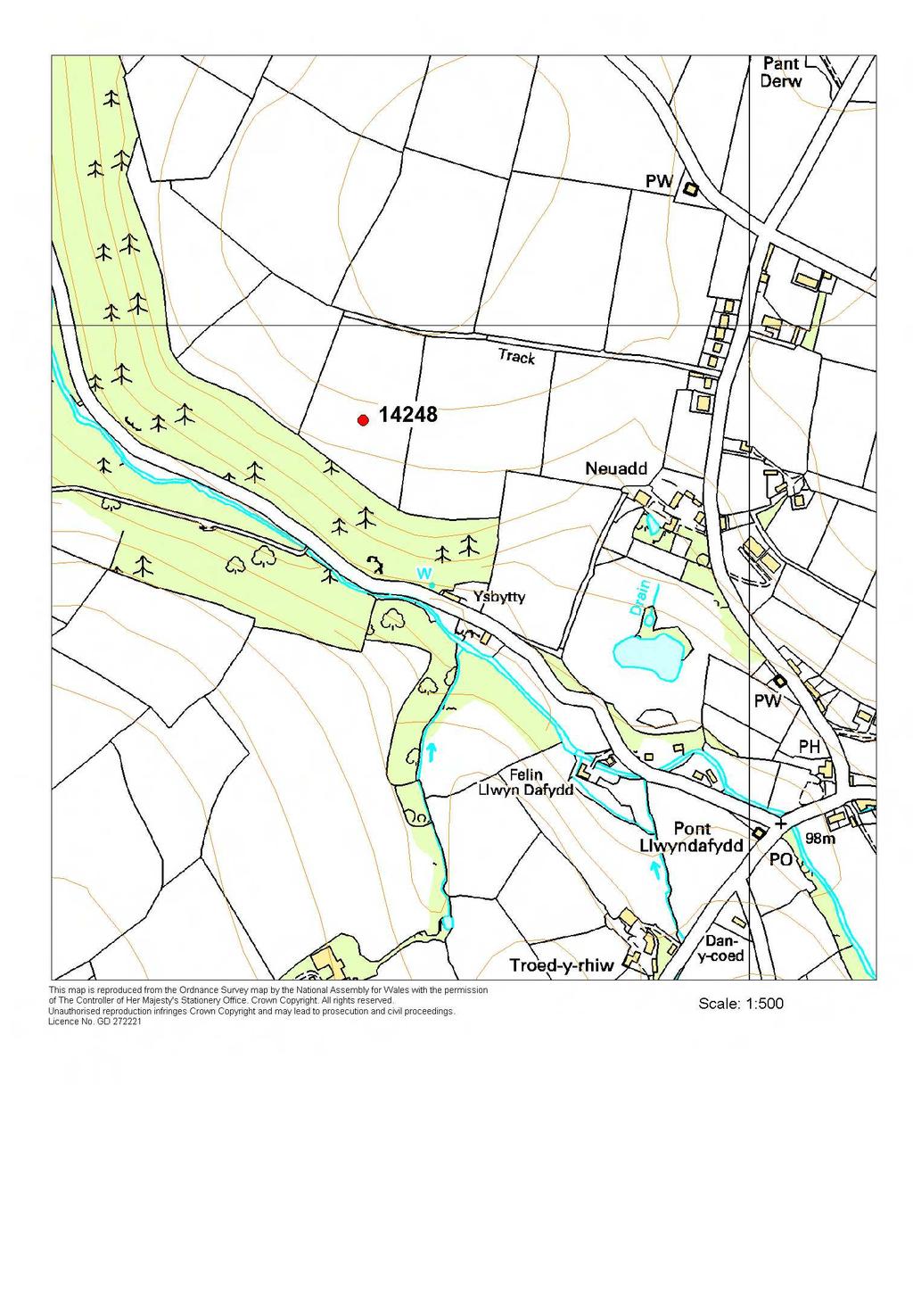
35 14248 NEUADD PRN NGR SN SITE NAME NEUADD SITE TYPE DEFENDED ENCLOSURE FORM Cropmark PERIOD Iron Age CONDITION D SITE STATUS DESCRIPTION A circular enclosure is visible on aerial photographs. The enclosure is defined by a cropmark ditch, there are no earthworks or surface indications of the site. The photograph indicates near circular enclosure, approximately 80m in diameter. It is faint cropmark; there is no sign of an entrance. The site lies on a south-facing slope, which is not constant, but levels out slightly at the site of the enclosure. To the south of the site the land falls steeply away into a small valley. In 2005, the site was under improved pasture. K Murphy 22 November 2005


36 Aerial photograph Cambria Archaeology Ground photograph looking over site of earthworks.
37
38 14806 PEN Y CASTELL PRN NGR SN SITE NAME PEN Y CASTELL SITE TYPE DEFENDED ENCLOSURE? FORM Earthwork PERIOD Iron Age CONDITION D SITE STATUS DESCRIPTION This site was described by K Ray in 1988 as occupying a shallow hilltop, and comprising a an embanked enclosure much reduced by ploughing and obscured by a later field bank built across it. The grid reference provided by Ray must be incorrect as it refers to a fairly level pasture field, which has no trace of an earthwork. There is a shallow hill some 350m to the northwest of grid reference provide, but a rapid appraisal of it failed to discover any earthwork. K Murphy 17 November 2005
39
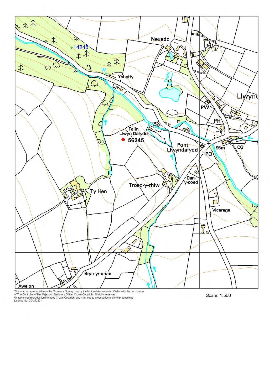
40 56245 FELIN LLWYN-DAFYDD PRN NGR SN SITE NAME SITE TYPE FELIN LLWYN-DAFYDD PROMONTORY FORT FORM Earthwork PERIOD Iron Age CONDITION U SITE STATUS DESCRIPTION Earthworks of a small promontory fort were noticed from the air by Toby Driver (RCAHMW) in 2004, but not photographed. Access to the land could not be arranged in 2005, so the character of this site has not been assessed. The site is located on a small inland promontory. To the west, north and east the land falls away by 10m -20m into small valleys. To the south the land is flat and the site is easily approachable. In 2005, the site was under improved pasture. K Murphy 22 November 2005

41 Ground photograph - sit e in middle distance.
42
43 REJECTED SITES Three sites originally recorded as defended enclosures or similar on the Historic Environment were rejected: originally recorded as a possible defensive site, this site was amended to a hedgebank following a field visit.
A SURVEY OF DEFENDED ENCLOSURES IN CEREDIGION, 2006: GAZETTEER OF ORDNANCE SURVEY GRID SQUARES SN45 AND SN46
 A SURVEY OF DEFENDED ENCLOSURES IN CEREDIGION, 2006: GAZETTEER OF ORDNANCE SURVEY GRID SQUARES SN45 AND SN46 Paratowyd gan Archaeoleg Cambria Ar gyfer Cadw Prepared by Cambria Archaeology ARCHAEOLEG CAMBRIA
A SURVEY OF DEFENDED ENCLOSURES IN CEREDIGION, 2006: GAZETTEER OF ORDNANCE SURVEY GRID SQUARES SN14 AND SN15
 A SURVEY OF DEFENDED ENCLOSURES IN CEREDIGION, 2006: GAZETTEER OF ORDNANCE SURVEY GRID SQUARES SN14 AND SN15 Paratowyd gan Archaeoleg Cambria Ar gyfer Cadw Prepared by Cambria Archaeology ARCHAEOLEG CAMBRIA
SCHEDULING ENHANCEMENT PROJECT 2011: PREHISTORIC SITES FIELDWORK PEMBROKESHIRE ADDITIONAL SITES
 SCHEDULING ENHANCEMENT PROJECT 2011: PREHISTORIC SITES FIELDWORK PEMBROKESHIRE ADDITIONAL SITES Detail of balanced stones part of enclosure PRN 100702 situated on Banc Llwydlos, Mynydd Preseli, recorded
THE PEMBROKESHIRE CEMETERIES PROJECT
 THE PEMBROKESHIRE CEMETERIES PROJECT EXCAVATIONS AT ST BRIDES HAVEN, PEMBROKESHIRE 2009 DYFED ARCHAEOLOGICAL TRUST RHIF YR ADRODDIAD / REPORT NO. 2009/39 RHIF Y PROSIECT / PROJECT RECORD NO.94896 Mawrth
Chiselbury Camp hillfort
 Chiselbury Camp hillfort Reasons for Designation Large univallate hillforts are defined as fortified enclosures of varying shape, ranging in size between 1ha and 10ha, located on hilltops and surrounded
ARFORDIR COASTAL HERITAGE
 ARFORDIR COASTAL HERITAGE 2011-2012 Prepared by Dyfed Archaeological Trust For Cadw DYFED ARCHAEOLOGICAL TRUST RHIF YR ADRODDIAD / REPORT NO. 2012/24 RHIF Y DIGWYDDIAD/ PROJECT RECORD NO. 102763 WHITESANDS
FOUNDATIONS OF ARCHAEOLOGY A WALK IN VERNDITCH CHASE
 FOUNDATIONS OF ARCHAEOLOGY A WALK IN VERNDITCH CHASE 1. A Tale of two Long Barrows Long barrows were constructed as earthen or drystone mounds with flanking ditches and acted as funerary monuments during
The Atlas of Hillforts of Britain and Ireland. Hillfort survey notes for guidance
 The Atlas of Hillforts of Britain and Ireland Hillfort survey notes for guidance The collection of surveys for the Atlas is now finished but you can use this form and the accompanying Notes for Guidance
Looking north from the SW shieling site with Lub na Luachrach in the foreground
 Looking north from the SW shieling site with Lub na Luachrach in the foreground Upper Gleann Goibhre - Shieling sites Two shieling sites in the upper reaches of the Allt Goibhre were visited and recorded
4. Bronze Age Ballybrowney, County Cork Eamonn Cotter
 4. Bronze Age Ballybrowney, County Cork Eamonn Cotter Illus. 1 Location map of the excavated features at Ballybrowney Lower (Archaeological Consultancy Services Ltd, based on the Ordnance Survey Ireland
Baggy Point, Croyde, North Devon
 Baggy Point, Croyde, North Devon A walk using the South West Coast Path that is likely to be suitable for people with impaired mobility or with a pushchair, wheelchair, or mobility scooter. The Coast Path
Cholesbury New House, Parrots Lane, Cholesbury, Buckinghamshire
 Cholesbury New House, Parrots Lane, Cholesbury, Buckinghamshire An Archaeological Watching Brief For Mr Martin Wood by Sean Wallis Thames Valley Archaeological Services Ltd Site Code PLC 06/135 March 2007
Afon Adda Refurbishment Bangor
 Afon Adda Refurbishment Bangor Archaeological Assessment Revised Report GAT Project No. 1876 Report No. 628 April 2006 Ymddiriedolaeth Archaeolegol Gwynedd Gwynedd Archaeological Trust Craig Beuno, Ffordd
Pen Cerrig-calch prehistoric cairns
 Walk Information: Maps: OS Explorer OL13 Distance: 8 miles / 13 kilometres Duration: Allow at least 6 hours for the circular walk Difficulty: medium. Some narrow paths, occasionally rough underfoot Start
Unlocking Our Coastal Heritage Project: Crane Castle Promontory Fort, Illogan, Cornwall
 Unlocking Our Coastal Heritage Project: Crane Castle Promontory Fort, Illogan, Cornwall As part of a wider project funded by the Rural Development Programme for England (RDPE) and administered through
Cadbury Hill. YCCCART Yatton, Congresbury, Claverham & Cleeve Archaeological Research Team
 YCCCART Yatton, Congresbury, Claverham & Cleeve Archaeological Research Team How old is it? Cadbury Hill The hill top of Cadbury-Congresbury has produced signs of activity in Neolithic and Bronze Age times
Wheatlands House, Fleet Hill, Finchampstead, Berkshire
 Wheatlands House, Fleet Hill, Finchampstead, Berkshire An Archaeological Watching Brief For JCA International by James McNicoll-Norbury Thames Valley Archaeological Services Ltd Site Code WFF 08/26 August
CWMGIEDD FROM ABERCRAVE
 Abercrave to Cwmgiedd Walk Page 1 Starting from The Abercrave Inn. Grid Ref: SN 824128 From the Abercrave Inn, an 11.3km (7 miles) walk to the foothills of the Cribarth Mountain, then through forest to
Brenig Archaeology Trail
 Walk Information: Maps: OS Explorer 264 Distance: 2.5 miles / 4 kilometres Duration: Allow 2.5 hours for the circular walk Difficulty: easy. Well-marked trail over fields. Start and finish: SH 98325741
Radnorshire Historic Settlements: Earthwork Survey
 THE CLWYD POWYS ARCHAEOLOGICAL TRUST I., ; I./ "oh';;: Radnorshire Historic Settlements: Earthwork Survey 1995-6 ;--- - ~.'l:1 ';, CPAT Report No 169 CPAT Report No 169 Radnorshire Historic Settlements:
Ystwyth and Rheidol Bridleway Routes. Route 2:Llanilar Circular
 Ystwyth and Rheidol Bridleway Routes Route 2:Llanilar Circular Route overview and terrain: A long circle using connecting ridges with fine views to link the Rheidol and Ystwyth river valleys. The route
ARCHAEOLOGICAL SITE SURVEY ON PONUI ISLAND, HAURAKI GULF, NEW ZEALAND. by Peter J. Matthews SUMMARY
 TANK 25, 1979 ARCHAEOLOGICAL SITE SURVEY ON PONUI ISLAND, HAURAKI GULF, NEW ZEALAND by Peter J. Matthews 3 Sadgrove Terrace, Mount Albert, Auckland 3 SUMMARY Thirty four archaeological sites were recorded
BISHOPSTONE CIRCULAR WALK
 BISHOPSTONE CIRCULAR WALK 4½ miles (7¼ km) - allow 2 hours (see maps on final pages) Introduction This walk is within the North Wessex Downs Area of Outstanding Natural Beauty and starts from the small,
Nelson Mandela Community School, Colville Road, Sparkbrook, Birmingham, B12 8EH. Erection of single storey detached learning pod building
 Committee Date: 7/07/204 Application Number: 204/0362/PA Accepted: 22/05/204 Application Type: Full Planning Target Date: 7/07/204 Ward: Sparkbrook Nelson Mandela Community School, Colville Road, Sparkbrook,
CASTLE OF OLD WICK HISTORIC ENVIRONMENT SCOTLAND STATEMENT OF SIGNIFICANCE. Property in Care(PIC) ID: PIC282 Designations:
 ID: PIC282 Designations:") Property in Care(PIC) ID: PIC282 Designations: Scheduled Monument (SM90065) Taken into State care: 1957 (Guardianship) Last reviewed: 2004 HISTORIC ENVIRONMENT SCOTLAND STATEMENT OF SIGNIFICANCE CASTLE
Property in Care(PIC) ID: PIC282 Designations: Scheduled Monument (SM90065) Taken into State care: 1957 (Guardianship) Last reviewed: 2004 HISTORIC ENVIRONMENT SCOTLAND STATEMENT OF SIGNIFICANCE CASTLE
archeological site LOS MILLARES
 archeological site LOS MILLARES Aerial view of the plain of Los Millares between the Rambla de Huéchar and the River Andarax The archaeological site of Los Millares is located in the township of Santa
Eglwyseg Mountain a landscape of prehistoric cairns and later industry
 Eglwyseg Mountain a landscape of prehistoric cairns and later industry Walk Information: Maps: OS Explorer 256 Distance: 5.3 miles / 8.5 kilometres (linear) or up to 9.6 miles / 15.5 kilometres (circular)
Report on an archaeological watching brief at Thomas Lord Audley School, Monkwick, Colchester
 Report on an archaeological watching brief at Thomas Lord Audley School, Monkwick, Colchester July 2000 for WS Atkins Property Services Colchester Archaeological Trust 12 Lexden Road, Colchester, Essex
Approximate distance: 5.5 miles For this walk we ve included OS grid references should you wish to use them. Start. End
 Approximate distance: 5.5 miles For this walk we ve included OS grid references should you wish to use them. Start End 2 1 5 4 6 3 N W E 7 S Reproduced by permission of Ordnance Survey on behalf of HMSO.
Hamilton School, Hamilton Road, Birmingham, B21 8AH
 Committee Date: 12/12/2013 Application Number: 2013/07822/PA Accepted: 17/10/2013 Application Type: Full Planning Target Date: 12/12/2013 Ward: Handsworth Wood Hamilton School, Hamilton Road, Birmingham,
In September, 1966, an
 ANNE S. ROBERTSON, D LITT THE ROMAN CAMP(S) ON HILLSIDE FARM, DUNBLANE, PERTHSHIRE This paper is published with the aid of a grantfrom H.M.Treasury In September, 1966, an emergency excavation was begun,
32-36 Gildas Avenue, Kings Norton, Birmingham, B38 9HR. Application for prior notification of proposed demolition
 Committee Date: 08/08/2013 Application Number: 2013/05430/PA Accepted: 23/07/2013 Application Type: Demolition Determination Target Date: 20/08/2013 Ward: Kings Norton 32-36 Gildas Avenue, Kings Norton,
29 Plas Derwen. Exploring Abergavenny
 29 Plas Derwen Exploring Abergavenny Cover: rhythm 2 plas derwen EXPLORING ABERGAVENNY For several years the Abergavenny and District Civic Society has been studying the streets, spaces and buildings of
^ox, 7. Environment Agency. Hayling Island North Strategy *. M ^, v. * > -.
 ^ox, 7 Environment Agency Hayling Island North Strategy *. M ^, v. * > -. Consultation Document for Preferred Coastal Defence Options - Septem ber 2005 We are the Environment Agency. It s our job to look
7. Poverty Bay and East Coast
 7. Poverty Bay and East Coast The first fighting in the Poverty Bay and East Coast regions took place in 1865 at Tokomaru Bay, Waiapu and Hicks Bay, mostly between sections of the Ngāti Porou tribe (Cowan
Wicklow Mountains Path Survey
 Wicklow Mountains Path Survey Glenmacnass Tonelagee Start to Finish: O 114 030 to O 085 016 Altitude (lowest highest): 370m 817m Weather: Sunny day, hot Access: Military Road, Glenmacnass Surveyed by:
Introduction to Map 30: Sgeir Alt Mhic Eoghainn to Ton Loisgte
 Introduction to : Sgeir Alt Mhic Eoghainn to Ton Loisgte This map section covers some 7.8km of coastline. This section takes in the south western facing butt of the Rhinns and includes the villages of
An Assessment of Lower Boddington
 W An Assessment of Lower Boddington Design and Conservation Team Reviewed Winter 2017 Contents Introduction... 2 Origins and Archaeology... 3 Historic Development... 3 Plan Form... 3 Space and relationship
ANTONINE WALL - BARHILL
 Property in Care (PIC)no: PIC168 Designations: Scheduled Monument (SM90008) Taken into State care: 1960 (Guardianship) Last reviewed: 2005 HISTORIC ENVIRONMENT SCOTLAND STATEMENT OF SIGNIFICANCE ANTONINE
An Analytical Earthwork Survey of the Hillfort at Fin Cop, Derbyshire
 An Analytical Earthwork Survey of the Hillfort at Fin Cop, Derbyshire Aerial photograph of the scarp edge Hillfort at Fin Cop viewed from the north-west. ( English Heritage) ARS Ltd Report No. ARS/34 May
Land off Birdie Way, Rush Green, Hertford, Hertfordshire
 Land off Birdie Way, Rush Green, Hertford, Hertfordshire An Archaeological Evaluation for Bride Hall Development Limited by Sarah Coles Thames Valley Archaeological Services Site Code RGH00/ 01 January
Wicklow Mountains Path Survey
 Wicklow Mountains Path Survey Ballinacor Croaghanmoira Fananierin Start to Finish: T 11723 86602 to T 11175 89057 Altitude (lowest highest): 385m 664m Weather: Hot Access: Coolgarrow forest entrance Surveyed
CASTLELAW HILL FORT HISTORIC ENVIRONMENT SCOTLAND STATEMENT OF SIGNIFICANCE. Property in Care (PIC) ID: PIC131
 ID: PIC131") Property in Care (PIC) ID: PIC131 Designations: Scheduled Monument (SM90064) Taken into State care: 1933 (Guardianship) Last reviewed: 2012 HISTORIC ENVIRONMENT SCOTLAND STATEMENT OF SIGNIFICANCE CASTLELAW
Property in Care (PIC) ID: PIC131 Designations: Scheduled Monument (SM90064) Taken into State care: 1933 (Guardianship) Last reviewed: 2012 HISTORIC ENVIRONMENT SCOTLAND STATEMENT OF SIGNIFICANCE CASTLELAW
The Old Shire Horse Centre, Bath Road, Woolley Green, Maidenhead, Berkshire
 The Old Shire Horse Centre, Bath Road, Woolley Green, Maidenhead, Berkshire An Archaeological Watching Brief For Mr Derek Chesterman by Andrew Mundin Thames Valley Archaeological Services Ltd Site Code
Self-Guided Walk Langdale Pikes. Start & Finish: NT car park (free to members) at Sticklebarn - on the right just beyond the New Dungeon Ghyll hotel.
 at Sticklebarn - on the right just beyond the New Dungeon Ghyll hotel.") Self-Guided Walk Langdale Pikes Key Information These mountains form a collection of spires and cliffs on the north side of Langdale. This walk visits four of the main tops Pavey Ark, Harrison Stickle,
Self-Guided Walk Langdale Pikes Key Information These mountains form a collection of spires and cliffs on the north side of Langdale. This walk visits four of the main tops Pavey Ark, Harrison Stickle,
CAPEL SAESNEG STRYD FAWR Y BALA LL23 7AG PRICE: 50,000. VIEWING: Strictly by appointment with the Selling Agents
 Ref: B.612 SURVEYORS ESTATE AGENTS AUCTIONEERS VALUERS A REDUNDANT CHAPEL BULDING CAPEL SAESNEG STRYD FAWR Y BALA LL23 7AG A freehold single cell detached Chapel building of solid stone construction under
Holyport Manor Special School, Highfield Lane, Cox Green, Maidenhead, Berkshire
 Holyport Manor Special School, Highfield Lane, Cox Green, Maidenhead, Berkshire An Archaeological recording action For CgMs Consulting by Jennifer Lowe Thames Valley Archaeological Services Ltd Site Code
Henderson Mess, RAF Halton, Buckinghamshire
 Henderson Mess, RAF Halton, Buckinghamshire An archaeological watching brief for Stepnell Ltd by Stephen Hammond Thames Valley Archaeological Services Ltd Site Code RHA03/85 October 2003 Summary Site name:
Excavations in a Medieval Market Town: Mountsorrel, Leicestershire,
 Excavations in a Medieval Market Town: Mountsorrel, Leicestershire, by John Lucas Mountsorrel is situated 12 kms north of Leicester and forms a linear settlement straddling the A6, Leicester to Derby road.
6 Results of NMP mapping
 6 Results of NMP mapping 6.1 Overview of results In general terms the nature of archaeological evidence available from aerial photographs determines the types of site recorded as part of NMP. Usually these
DEFENCE AREA 52 SPEETON
 DEFENCE AREA 52 SPEETON 1. Area details: Speeton is 4½ miles S of Filey and 6 miles N of Bridlington. County: North Yorkshire. Parish: Reighton. NGR: centre of area, TA 147751. 1.1 Area Description: [see
MEDIEVAL AND EARLY POST-MEDIEVAL DEER PARKS
 MEDIEVAL AND EARLY POST-MEDIEVAL DEER PARKS A THREAT-RELATED ASSESSMENT 2015 Prepared by Dyfed Archaeological Trust For Cadw DYFED ARCHAEOLOGICAL TRUST DAT Event Record No. 107260 Report No. 2015/18 Cadw
St. Clements C of E Academy, Butlin Street, Birmingham, B7 5NS. Installation of multi-use games area and associated access works.
 Committee Date: 12/06/2014 Application Number: 2014/02723/PA Accepted: 22/04/2014 Application Type: Full Planning Target Date: 17/06/2014 Ward: Nechells St. Clements C of E Academy, Butlin Street, Birmingham,
Following the initial soil strip archaeology is sprayed up prior to planning and excavation
 Barton Quarry & Archaeology Over the past half century quarries have been increasingly highlighted as important sources of information for geologists, palaeontologists and archaeologists, both through
DEFENCE AREA 73 FRESHWATER BAY
 DEFENCE AREA 73 FRESHWATER BAY 1. Area details: The defence area is 3½ miles from The Needles and 10 miles W of Newport. County: Isle of Wight. Parish: Freshwater. NGR: centre of area, SZ 346860. 1.1 Area
The Tel Burna Archaeological Project Report on the First Season of Excavation, 2010
 The Tel Burna Archaeological Project Report on the First Season of Excavation, 2010 By Itzick Shai and Joe Uziel Albright Institute for Archaeological Research Jerusalem, Israel April 2011 The site of
For Sale shott HoUse and development land with detailed planning Consent for four detached villas Hamilton Road, HigH BlantyRe, glasgow g72 9Ud
 For Sale Shott House and Development Land with Detailed Planning Consent for Four Detached Villas Hamilton Road, High Blantyre, Glasgow G72 9UD The Opportunity Savills are delighted to bring to the market
I I I I LINDEN TO WOOD FORD SURVEY ITEMS OF HISTORICAL SIGNIFICANCE I I I I I I I I I I I I I
 LNDEN TO WOOD FORD SURVEY TEMS OF HSTORCAL SGNFCANCE ------------------------------------------------------------------------------ --- - CONTENTS OF THE REPORT 1.0 ntroduction to the Report 1.1 Parameters
Archaeology 1:25,000. Map 4. Previously known site. Site found by this survey (pale symbol means described on previous map)
") Archaeology 1:25,000 Map 4 148 18 17 13 12 16 15 14 147 11 149 Crown copyright. All rights reserved. Historic Scotland Licence No. 100017509 [2009] 150 0 0.5 1 Km Previously known site Site found by this
Archaeology 1:25,000 Map 4 148 18 17 13 12 16 15 14 147 11 149 Crown copyright. All rights reserved. Historic Scotland Licence No. 100017509 [2009] 150 0 0.5 1 Km Previously known site Site found by this
Monitoring Report No. 227
 City of Derry Airport Longfield More townland Eglinton County Derry AE/10/61 Ruth Logue Site Specific Information Site location: City of Derry Airport, Airport Road, Eglinton, BT47 3GY Townland: Longfield
2009 No ANTARCTICA. The Antarctic (Amendment) Regulations 2009
 Regulations 2009") STATUTORY INSTRUMENTS 2009 No. 2354 ANTARCTICA The Antarctic (Amendment) Regulations 2009 Made - - - - 23rd August 2009 Laid before Parliament 1st September 2009 Coming into force - - 22nd September 2009
STATUTORY INSTRUMENTS 2009 No. 2354 ANTARCTICA The Antarctic (Amendment) Regulations 2009 Made - - - - 23rd August 2009 Laid before Parliament 1st September 2009 Coming into force - - 22nd September 2009
A Possible Roman Road Discovered in Lanarkshire
 A Possible Roman Road Discovered in Lanarkshire In the eighteenth century, William Roy documented the Roman road network that provided communication between the Castledykes fort (near Carstairs, Lanarkshire)
Trefri Hall. Aberdovey
 Trefri Hall Aberdovey A fine Georgian house with cottage, private island and beach on the breathtakingly beautiful Dovey Estuary with views out to the Cardigan Bay Trefri Hall, Aberdovey, Gwynedd LL35
APPENDIX G ECOLOGICAL REPORTS. G.2 Badger
 APPENDIX G ECOLOGICAL REPORTS G.2 Badger Damhead Creek 2 ES Volume 2 June 2009 Damhead Creek Phase II Proposed Development Badger Survey Results Survey Date: 26 th October 2006. Surveyors: Miranda Cowan
Conservation Area Consent for demolition of existing building
 Committee Date: 19/09/2013 Application Number: 2013/02378/PA Accepted: 03/05/2013 Application Type: Conservation Area Target Date: 28/06/2013 Consent Ward: Ladywood 34 Carver Street, Jewellery Quarter,
BRONZE AGE FIELD SYSTEM AT SOUTHAMPTON AIRPORT
 Proc. Hampshire Field Club Archaeol. Soc. 65, 2010, 1-6 (Hampshire Studies 2010) BRONZE AGE FIELD SYSTEM AT SOUTHAMPTON AIRPORT By J SULIKOWSKA With contributions by LORRAINE MEPHAM and CHRIS J STEVENS
Lake Wissota Access Locations within the LaFayette Township. By Chad Martin
 Lake Wissota Access Locations within the LaFayette Township By Chad Martin Anson/ Wissota Access Point # 1 Road: 195 th St. Associated Fire Numbers: 13294 Defining Characteristics: Forested from road
Archaeological Investigations Project South East Region SOUTHAMPTON 2/842 (C.80.C004) SU
 SU") SOUTHAMPTON City of Southampton 2/842 (C.80.C004) SU 4382 1336 125 BITTERNE ROAD WEST, SOUTHAMPTON Report on the Archaeological Evaluation Excavation at 125 Bitterne Road West, Southampton Russel, A. D
SOUTHAMPTON City of Southampton 2/842 (C.80.C004) SU 4382 1336 125 BITTERNE ROAD WEST, SOUTHAMPTON Report on the Archaeological Evaluation Excavation at 125 Bitterne Road West, Southampton Russel, A. D
An archaeological excavation and watching brief at the Musket Club, Homefield Road, Colchester, Essex December 2004-February 2005
 An archaeological excavation and watching brief at the Musket Club, Homefield Road, Colchester, Essex December 2004-February 2005 report prepared by Howard Brooks on behalf of RMPA and the MoD CAT project
TURNPIKE and PRE-TURNPIKE ROADS
 TURNPIKE and PRE-TURNPIKE ROADS Medieval and Early Post-Medieval Sites Scheduling Enhancement Project 2016 Prepared by Dyfed Archaeological Trust For Cadw DYFED ARCHAEOLOGICAL TRUST REPORT NO. 2016/61
The Appleton Wetland; Its Decline, Cause and Recommended Action. Appendix K: Wetland Inspection
 The Appleton Wetland; Its Decline, Cause and Recommended Action Appendix K: Wetland Inspection Report prepared by Appleton Wetland Research Group of the Mississippi Valley Field Naturalists Research Group
Kelling to Lowestoft Ness Shoreline Management Plan. 6 Sites of Special Scientific Interest (SSSI)
") ECOM Kelling to Lowestoft Ness Shoreline Management Plan 6 Sites of Special Scientific Interest () 1 Weybourne Cliffs 2 Kelling Heath 3 Weybourne Town Pit 6.1 4 Beeston Cliffs 6.2 5 Sheringham and Beeston
ECOM Kelling to Lowestoft Ness Shoreline Management Plan 6 Sites of Special Scientific Interest () 1 Weybourne Cliffs 2 Kelling Heath 3 Weybourne Town Pit 6.1 4 Beeston Cliffs 6.2 5 Sheringham and Beeston
Wessex Archaeology. Little Stubbings, West Amesbury, Salisbury, Wiltshire. Archaeological Watching Brief. Ref:
 Wessex Archaeology Little Stubbings, West Amesbury, Salisbury, Wiltshire Ref: 63280.02 March 2007 LITTLE STUBBINGS, WEST AMESBURY, NR SALISBURY, WILTSHIRE ARCHAEOLOGICAL WATCHING BRIEF Prepared for: P
Survey of Deadwater Fell and Peel Fell
 4 December 2014 Survey of Deadwater Fell and Peel Fell Team: John Barnard, Chris Crocker, Richard Cooper and Graham Jackson 1) Introduction Deadwater Fell (Hill 3542, Section 33, OS 1:50000 Map 80, OS
7 Knowsley. 7.1 Location and administration
 7 Knowsley 7.1 Location and administration The Metropolitan Borough of Knowsley is a metropolitan borough of Merseyside, covering some 86.17km 2. Knowsley comprises a belt of small towns, suburbs and countryside,
DEFENCE AREA 15 ACLE. 2. Assessment.
 DEFENCE AREA 15 ACLE 1. Area details: Acle is 11 miles E of Norwich and 8 miles W of Great Yarmouth. County: Norfolk. Parishes: Acle / Upton with Fishley. NGR: centre of area, TG 401105. 1.1 Area Description:
Walton Basin. archaeology and conservation. Bill Britnell THE CLWYD-POWYS ARCHAEOLOGICAL TRUST
 Walton Basin archaeology and conservation Bill Britnell THE CLWYD-POWYS ARCHAEOLOGICAL TRUST Published with the help of grant aid from Cadw Welsh Government Contents Published by The Clwyd-Powys Archaeological
Pembrokeshire coastal farm set in stunning location. treathro, trefasser, strumble head, nr fishguard, pembrokeshire, sa64 0lr
 Pembrokeshire coastal farm set in stunning location treathro, trefasser, strumble head, nr fishguard, pembrokeshire, sa64 0lr Pembrokeshire coastal farm set in stunning location treathro trefasser, strumble
HILLFORT STUDY GROUP HILLFORTS IN DORSET A GUIDE TO THE SITES VISITED DURING THE INAUGURAL CONFERENCE AT DORCHESTER, DORSET APRIL 29 - MAY
 HILLFORT STUDY GROUP HILLFORTS IN DORSET A GUIDE TO THE SITES VISITED DURING THE INAUGURAL CONFERENCE AT DORCHESTER, DORSET APRIL 29 - MAY 1 1966 Chalbury (after C. Warne Ancient Dorset, (1872), Plate
S E R V I C E S. Land to the rear of Ashdown, Basingstoke Road, Spencers Wood, Reading, Berkshire. Archaeological Evaluation.
 T H A M E S V A L L E Y ARCHAEOLOGICAL S E R V I C E S Land to the rear of Ashdown, Basingstoke Road, Spencers Wood, Reading, Berkshire Archaeological Evaluation by Susan Porter Site Code: ASW12/21 (SU
11 Majors Barn. 19 Mill Street Exploring Abergavenny
 11 Majors Barn 19 Mill Street Exploring Abergavenny Cover: Mill Street from Monmouth Road 2 mill street EXPLORING ABERGAVENNY For several years the Abergavenny and District Civic Society has been studying
The Mendip Way. Route Directions and Maps Uphill to Wells
 The Mendip Way Route Directions and Maps Uphill to Wells Website: www.mendiphillsaonb.org.uk Email: mendip@mendiphillsaonb.org.uk Facebook & Twitter: @MendipHillsAONB Phone: 01761462338 1 Uphill to Loxton
Scheduled Monument (SM90085) Taken into State care: 1966 (Guardianship) Last reviewed: 2004 CROOKSTON CASTLE
 Taken into State care: 1966 (Guardianship) Last reviewed: 2004 CROOKSTON CASTLE") Property in Care (PIC) ID: PIC119 Designations: Scheduled Monument (SM90085) Taken into State care: 1966 (Guardianship) Last reviewed: 2004 HISTORIC ENVIRONMENT SCOTLAND STATEMENT OF SIGNIFICANCE CROOKSTON
Property in Care (PIC) ID: PIC119 Designations: Scheduled Monument (SM90085) Taken into State care: 1966 (Guardianship) Last reviewed: 2004 HISTORIC ENVIRONMENT SCOTLAND STATEMENT OF SIGNIFICANCE CROOKSTON
Leptis Magna. 9 LEPTIS MAGNA s NORTH COAST
 9 LEPTIS MAGNA s NORTH COAST The following observations were made on August 24, 25 and 26, 2000, thanks to the kind hospitality of the late Professor André Laronde during his year 2000 campaign of the
Trail Summary. Defending Hope. Three Forts Time Travellers Trail (Hope Valley)
") 6hr Jump on a bus to explore the sites of three former defensive outposts in the Hope Valley. Navio Roman Fort has level access, whilst Mam Tor and Peveril Castle require a steep climb (hence there defensive
6hr Jump on a bus to explore the sites of three former defensive outposts in the Hope Valley. Navio Roman Fort has level access, whilst Mam Tor and Peveril Castle require a steep climb (hence there defensive
2 The Monuments and Their Setting by Mark Corney and Andrew Payne
 2 The Monuments and Their Setting by Mark Corney and Andrew Payne The sites examined provide a representative regional sample of those sites traditionally classified as hillforts in the Wessex region.
DEFENCE AREA 35 FREISTON SHORE
 DEFENCE AREA 35 FREISTON SHORE 1. Area details: Freiston Shore is 2 miles E of Freiston village and 5 miles E of Boston. County: Lincolnshire. Parish: Freiston. NGR: centre of area, TF 397424. 1.1 Area
Introduction to Topographic Maps
 Introduction to Topographic Maps DIRECTIONS: Read all of the following content. READ EVERYTHING!! At the end of the packet, you will find two topographic maps. Your task is to indentify each of the elevations
Visual and Sensory Aspect
 Updated All Wales LANDMAP Statistics 2017 Visual and Sensory Aspect Final Report for Natural Resources Wales February 2018 Tel: 029 2043 7841 Email: sw@whiteconsultants.co.uk Web: www.whiteconsultants.co.uk
ARCHAEOLOGICAL DESKTOP ASSESSMENT
 Rose Energy ARCHAEOLOGICAL DESKTOP ASSESSMENT In relation to a proposed Biomass Fuelled Power Plant At Land off Ballyvannon Road, Nr Glenavy, County Antrim 2 ROSE ENERGY PROJECT, GLENAVY CO. ANTRIM ARCHAEOLOGICAL
Gors Lydan barrows and medieval huts
 Walk Information: Maps: OS Explorer 214 Distance: 5.5 miles / 9 kilometres Duration: 4.5 to 5 hours Difficulty: Easy. Good paths and no steep gradients Start and finish: SO 11977545 Walk summary The walk
An archaeological excavation at 193 High Street, Kelvedon, Essex September 2009
 An archaeological excavation at 193 High Street, Kelvedon, Essex September 2009 report prepared by Ben Holloway and Howard Brooks on behalf of Marden Homes CAT project ref.: 09/4g NGR: TL 8631 1913 (c)
From the car park go through the wooden gate and walk to a large information board and wooden totem pole ahead of you.
 Trail Dave Price, Geograph (CCL) Twin peaks What are these striking wooded hills here in an otherwise flat landscape? Time: 40-60 mins Distance: 1 ¼ miles Landscape: rural Standing at over 300 feet tall
Guthega to Mt Twynam. 2183m. 1583m. 6 hrs 45 mins 14.8 km Return. Experienced only. 913m
 Guthega to Mt Twynam 6 hrs 45 mins 14.8 km Return Experienced only 5 913m This walk starts from Guthega and makes its way along the Snowy River to the Illawong Lodge, via the Blue Cow Creek flying fox.
Freshwater East and Manorbier
 No: 37 Seascape Character Area Name: Freshwater East and Manorbier Manorbier beach and the Priest s Nose Cliff path on the Priest s Nose looking west Freshwater East looking east 37-1 Summary Description
Reservoir Tin workings
 The workings are quite over-grown and covered in moss, suggesting that they date to the earliest period of mining. This is supported by the fact that their head race was cut off by the reservoir (D49/47)
PROPOSAL TO AMEND THE HEART OF NEOLITHIC ORKNEY WORLD HERITAGE SITE BUFFER ZONE
 Heart of Neolithic Orkney World Heritage Site, Buffer Zone Modification Proposal. January 2013. PROPOSAL TO AMEND THE HEART OF NEOLITHIC ORKNEY WORLD HERITAGE SITE BUFFER ZONE This report has been developed
A487 PONT SEIONT ARCHAEOLOGICAL RECORDING REPORT NO Y mddiriedolaeth Archaeolegol Gwynedd Gwynedd Archaeological Trust
 A487 PONT SEIONT ARCHAEOLOGICAL RECORDING REPORT NO. 148 Y mddiriedolaeth Archaeolegol Gwynedd Gwynedd Archaeological Trust A487 PONT SEIONT ARCHAEOLOGICAL RECORDING prepared for Welsh Office Highways
Appendices A (Our ambition for nature (A3 plan) and further information)
 and further information)") Appendices A (Our ambition for nature (A3 plan) and further information) Penny Hill Farm Nature Conservation vision Key: Tenancy boundary Meadow restoration & Mowing/meadow F33 Mowing/meadow Progress towards
Appendices A (Our ambition for nature (A3 plan) and further information) Penny Hill Farm Nature Conservation vision Key: Tenancy boundary Meadow restoration & Mowing/meadow F33 Mowing/meadow Progress towards
Register of Parks and Gardens of Special Historic Interest in England. The first publicly owned park in Bradford, open in early 1850s.
 Register of Parks and Gardens of Special Historic Interest in England West Yorkshire Bradford Bradford Peel Park GD3330 II The first publicly owned park in Bradford, open in early 1850s. Historic Development