Lynde Creek Watershed LYNDE CREEK WATERSHED EXISTING CONDITIONS REPORT CHAPTER 2 HUMAN HERITAGE
|
|
|
- Rudolph Lewis
- 6 years ago
- Views:
Transcription


1 Lynde Creek Watershed CLOCA Lynde Creek Watershed LYNDE CREEK WATERSHED EXISTING CONDITIONS REPORT CHAPTER 2 HUMAN HERITAGE June 2008 CLOCA
2 TABLE OF CONTENTS 1.0 INTRODUCTION STUDY AREA AND SCOPE METHODOLOGY FINDINGS Settlement of the Lynde Creek Watershed Settlement in the Lynde Main Subwatershed Settlement in Heber Down Subwatershed Settlement in the Kinsale Subwatershed Settlement in the Ashburn Subwatershed Settlement in the Myrtle Station Subwatershed CONCLUSION REFERENCES LIST OF FIGURES Figure 1: Lynde Creek watershed....5 Figure 2: Lynde Main subwatershed....8 Figure 3: Heber Down subwatershed...11 Figure 4: Kinsale subwatershed...13 Figure 5: Ashburn subwatershed...15 Figure 6: Myrtle Station subwatershed...17 Page 2 of 19


3 1.0 INTRODUCTION Lynde Creek has played a role in the lives of the local human population since the time when only First Nations people inhabited this land. Initial European settlers and their descendants also made use of the creek, and the legacy of their interaction with the watercourse is still apparent in the landscape today. Lynde Creek has gone by many names: In the northern watershed, it was once known as Bickell s Creek, named after a local mill owner. It was also called Lloyd s Creek after David Lloyd who owned property near the mouth of the creek until about 1804 when it was then referred to as Lynde Creek after Jabez Lynde. Lynde (apparently properly pronounced lined ) also has historic spellings as Lyons and Leaned. Despite these changing names, the creek has consistently played a key role in the lives of those who settled on adjacent lands (Whitby Historical Society, 1983; Winter, 1999). History is an important backdrop for a watershed management plan. Understanding the historical interactions between the creek and its surrounding community assists in understanding the relationship between the land, water and human populations in the watershed. In other words, current issues within the Lynde Creek watershed are better understood in the context of the history of the local area. This chapter explores some of the historical interactions between the watershed s human population and the creek that runs through their area. despite these changing names, the creek has consistently played a key role in the lives of those who settled on adjacent lands Lynde Creek Watershed CLOCA Page 3 of 19


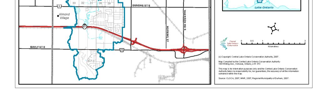
4 2.0 STUDY AREA AND SCOPE Lynde Creek and its tributaries drain an area of approximately 130 km 2 (Figure 1). The watershed is located entirely within the Regional Municipality of Durham and traverses five local municipalities (Town of Uxbridge, Township of Scugog, City of Pickering, Town of Ajax, and the Town of Whitby). The watershed s headwaters originate in the Oak Ridges Moraine and the water drains south to its outlet into Lake Ontario through the Lynde Creek Marsh. The watershed is divided into five subwatersheds: Lynde Main, Heber Down, Kinsale, Ashburn, and Myrtle Station. Both urban and rural land uses persist within this watershed with the urban area occupying most of the south portion of the watershed. The majority of the village of Brooklin is also located within the watershed. In addition, there are a number of hamlets situated within the Lynde Creek watershed: Almond Village, Macedonian Village, Kinsale, Myrtle Station, Myrtle, and Ashburn. With the exception of Kinsale, these Hamlets are all located within the Town of Whitby. Some information is available regarding the historic development of the Township of Whitby, Town of Whitby, hamlets and the Township of Pickering. Much of this information is site specific and as such is relevant to the historical settlement of certain subwatersheds. The historic settlement and development of the Town of Whitby offers a framework and valuable insight into present day Whitby and the Lynde Creek watershed. Admittedly the historic development of the Town of Whitby occurred predominantly within the Pringle watershed, yet its influence on Lynde Creek cannot be overlooked. the historic settlement and development of the Town of Whitby offers a framework and valuable insight into present day Whitby and the Lynde Creek watershed Information on the historic development of the Township of Pickering is also available and is relevant in the development of the Kinsale subwatershed in particular. Native history is presented on a broader scale, partly due to the limited knowledge that exists regarding native settlement within the watershed. Lynde Creek Watershed Page 4 of 19


5 Figure 1: Lynde Creek watershed. Page 5 of 19
6 3.0 METHODOLOGY Information was collected predominantly by means of a literature review, with much of the information coming from a couple of authors as well as the Whitby Historical Society, Whitby Local Architectural Conservation Advisory Committee (LACAC) and the Town of Whitby. 4.0 FINDINGS 4.1 Settlement of the Lynde Creek Watershed Native History In the early seventeenth century the Algonkians and the Iroquoians lived in present day southern Ontario. The Iroquoians included the Hurons and the Five Nations or Iroquois Confederacy and lived south of the Algonkians. The Iroquoians were hunters and gatherers, but they also relied on horticulture for their survival (Smith, 1991). By the eighteenth century, the Algonkians (the Ojibwa) had expelled the Iroquoians from southern Ontario and took control of the territory. Europeans called all the Ojibwa peoples Mississauga despite the fact that very few of them were actually from that band (Smith, 1991). A brief description of the lifestyle that those who utilized Lynde Creek may have had is provided by Smith (1991): in the early seventeenth century the Algonkians and the Iroquoians lived in present day southern Ontario During the winter the Mississauga traveled to their hunting grounds (which reached from the lake to the heads of the watersheds of the rivers draining in to the north shore of Lake Ontario). In the early spring they gathered at their maple sugar bushes to collect the sap needed to make maple sugar. During the summer they speared salmon at their river encampments by the river mouths. In the late summer the women harvested the corn that they had planted on the river flats in the spring. When fall arrived the small villages broke up into family hunting groups who again returned by foot or by canoe to their inland ranges. Printed sources of Native history specific to the Lynde Creek area are limited, yet there is some indication that Native peoples occupied this watershed. An archaeological excavation conducted in the 1990 s resulted in the discovery of an assortment of artifacts along the north shore of Lake Ontario around the Lynde Creek Marsh (Archaeological Services Inc., 1997.). The artifacts indicate that Native peoples made Page 6 of 19
7 seasonal use of the area during the Archaic, Middle Archaic, Late Archaic, Early and Middle Woodland, and Late Woodland periods of history. These historical eras date back from 10,000 years ago. It appears that the area was used as a seasonal camp because it provided excellent resources such as waterfowl, vegetation, and possibly large game (Archaeological Services Inc., 1997). Local historical records also contain some speculative accounts regarding Native peoples presence in the Brooklin area (Batty, undated). 4.2 Settlement in the Lynde Main Subwatershed In 1795, the Township of Whitby was surveyed and mapped for the first time by the British, establishing the lots, concessions and side roads still used today. The British intended to provide a new colony and land for resettlement of the Loyalists in the Township of Whitby. However, this did not occur, and the land was sold to those who could afford it, in this case mostly Americans (Whitby LACAC). Before 1805, the creek was called Lloyd Creek after David Lloyd who had settled at the mouth of the creek (Ontario Ministry of Culture, undated.). In 1804, Jabez Lynde, an American, arrived, settling near the current intersection of Kingston Road (Dundas Street) and the creek that now bears his name. It was at this time that the creek became commonly referred to as Lynde Creek. Although settlement of the area dates back to 1800, it was not until 1836 that the Town s founder, Peter Perry, established a downtown business centre. The Town experienced its first period of extensive growth in the 1850 s when its population grew from 1,000 to 3,500 within five years. The Town of Whitby was incorporated in 1855, three years later it was chosen as the seat of government for the new County of Ontario. After the 1850 s, Whitby's population remained stable for about 80 years. The McKinley Tariff Act in the United States ended the grain trade at the harbour in the 1890 s and Whitby became known as a retired farmers' town. After the Second World War, Whitby began attracting industry from Toronto and began to grow again, reaching a population of 15,000 in in 1795, the Township of Whitby was surveyed and mapped for the first time by the British, establishing the lots, concessions and side roads still used today In the 1960 s the Town of Whitby and the Township of Whitby were amalgamated. This was also the time when Whitby started to experience new residential development in the form of subdivisions. This growth has continued and in 2007 Whitby s population is 116,000 (Town of Whitby, 2007). It is anticipated that Whitby s population in 2031 will be 226,190 (Region of Durham, 2006). Brooklin The majority of Brooklin is situated within the Lynde Main subwatershed of the Lynde Creek (Figure 2). The western portion of Brooklin is located within the Heber Down subwatershed and the eastern most part being in the Pringle Creek watershed. Page 7 of 19

8 Figure 2: Lynde Main subwatershed. Page 8 of 19
9 The first land cleared in the area is believed to have been on the north side of Concession 6, owned by a Mr. Huntington who arrived around 1820 (Batty, undated). Approximately 20 years later, the community of Brooklin, originally named Winchester, had 4 log homes within the village and a flour mill built by John and Robert Campbell on the banks of the Lynde Creek (BRAY Heritage, 2006). In 1847, the village became known as Brooklin and there is some speculation that the watercourse flowing through the area inspired the name (Winter, 1999; Brooklin Downtown Business Association, 1997). By 1851 the village population was about 500 people and had two grist mills with three run of stones each (BRAY Heritage, 2006). By the 1870 s, industry and commerce were thriving and Brooklin continued to service the surrounding rural community. Growth was supported by the railway and roads. The first road through Brooklin was a blazed trail that came north from Hamer s Corners (now part of the Town of Whitby). This route went all the way to Whitby Harbour and was used to transport grain from the northern townships to the lakefront for export (Wick, 1981). Brooklin area farms produced internationally recognized milled flour and oatmeal and local stock breeders won acclaim nationally and internationally for their cattle and horses (BRAY Heritage, 2006). The creek was important to the village s development as is reflected in the following statement: The stream known as Bickell s Creek exerted much productive energy through a long period of years. At least seven mills were turned by its force within a distance of three miles. These included three grist mills, two sawmills, one oatmeal mill and a woolen mill...millpond after millpond dotted the stream...today the bottoms of the old ponds have become pasture fields (Batty, undated). The creek also provided other economic benefits as is noted in the 1871 census which reported that residents living alongside the creek were able to hunt, gathering the pelts of muskrats, mink and beaver (BRAY Heritage, 2006). However, Batty offers an indication of the effect of agricultural clearing on the flows of this watercourse:...unfortunately, as trees were cut down on this, and later on, surrounding property, the little stream dwindled to a trickle until it became only a drainage ditch for surplus surface water the creek was important to the village s development as if reflected in the following statement: The stream known as Bickell s Creek exerted much productive energy through a long period of years By the turn of the century, Brooklin was experiencing a downturn in its prosperity. This was in part due to the decline of the local mills and some natural disasters including flooding, fire and lightening strikes (BRAY Heritage, 2006). In 1890 high water levels in Lynde Creek swept away bridges, mill dams, railway and telegraph lines and small structures (BRAY Heritage, 2006). Today Brooklin is experiencing growth in the form of new residential development. This growth was initiated largely due to the expansion of municipal services from Whitby to Brooklin in the 1990s. The population of Brooklin in 2005 was approximately 15,000. Brooklin s population is expected to increase to 20,000 by the year 2011 and 30,000 by 2016 (Town of Whitby, 2007). To support this residential Page 9 of 19

.")
10 growth, there has been some development of commercial and service uses in the last couple of years. 4.3 Settlement in Heber Down Subwatershed A small community know as Bagotville was situated approximately one half mile west of the current Cullen Gardens/Cullen Central Park site. The community included a gristmill, and the Patly Mills and persisted until the 1920 s. The millpond was once located on land which is now part of the Cullen Gardens/Cullen Central Park property (Winter, 1999). The hamlet of Macedonian Village is located within this subwatershed (Figure 3). This hamlet has about residential homes and a municipal park. There are a couple of older homes, but the majority of homes appear to be built between the 1960 s and 1980 s, and there are a few homes that have been built in the last 5-10 years. the hamlet of Macedonian Village has about residential homes and a municipal park Heber Down Subwatershed Lou Wise Heber Down Subwatershed CLOCA Page 10 of 19

11 Figure 3: Heber Down subwatershed. Page 11 of 19
. Pickering Township was surveyed in 1791 by Augustus Jones, Deputy Provincial Land Surveyor.")
12 4.4 Settlement in the Kinsale Subwatershed This subwatershed currently spans three different municipal jurisdictions: Whitby, Pickering and Ajax. The majority of the headwaters of this subwatershed are located within Pickering (Figure 4). Pickering Township was surveyed in 1791 by Augustus Jones, Deputy Provincial Land Surveyor. The site of the later village of Pickering on Duffin's Creek was part of the 4800-acre block in Pickering granted in 1793 to Major John Smith, an officer in the 5th Regiment during the Revolutionary War and later commanding officer at Detroit ( ) and Niagara ( ). On Major Smith's death, the land passed to his son, David W. Smith, Surveyor-General of Upper Canada ( ). In 1797 Smith planned to erect a saw and grist-mill in the township. However, these mills were never built (Toronto and Region Conservation Authority, 2002). Kinsale The village of Kinsale is located at the intersection of Kinsale Road and Highway 7 in Pickering. It is reported that in the 1850 s a post office and school were established in the village. The Lovell s Gazetteer of British North America identifies the village of Kinsale as having a population of 90 people in The 1878 atlas map shows all the buildings in the village situated on the west side of Kinsale Road, with a branch of the Lynde Creek flowing through the intersection (Toronto and Region Conservation Authority, 2002). Almonds was named after James Almond who arrived in the area during the 1830s Almonds At the intersection of what is now Lakeridge Road and Highway 2 (Dundas Street) there was a small settlement called Almonds. The community was named after James Almond who arrived in the area during the 1830 s. For many years, Almonds was a distinct community boasting its own school and church (Winter, 1999). All that remains now on the site of this community is a small replica of the church and an historical information plaque. Despite the fact that this village has vanished, the name persists as the small community located east of Lakeridge Road and north of Highway 401 is referred to as Almond Village. This hamlet has approximately residential homes that were predominantly established during the 1950 s, 60 s and 70 s. Kinsale Subwatershed Lou Wise Page 12 of 19
13 Figure 4: Kinsale subwatershed. Page 13 of 19


14 4.5 Settlement in the Ashburn Subwatershed Originally known as Butler s Corners after the area s first settler, the community of Ashburn first emerged circa 1831 (Figure 5). The name Ashburn was eventually chosen in 1850 as a result of the community s link to the potash industry. Asheries were built to produce potash from the trees that were cleared during the settlement of Whitby Township. The first residents of Ashburn were primarily Scottish immigrants and some of these families are still in the community today. In addition, some key buildings from the community s early days, such as the general store (circa 1850) and the Wilson Hotel (circa 1869) still stand (Winter, 1999). the name Ashburn was eventually chosen in 1850 as a result of the community s link to the potash industry Ashburn Subwatershed CLOCA Page 14 of 19
15 Figure 5: Ashburn subwatershed. Page 15 of 19

16 4.6 Settlement in the Myrtle Station Subwatershed Two small hamlets in the northern portion of the watershed along Highway 12 are literally within walking distance of each other (Figure 6). These are the hamlets of Myrtle and Myrtle Station. Only the western portions of these hamlets are located within the Lynde Creek watershed, with the remainder being located within the Oshawa Creek watershed. Myrtle was officially established in the 1840 s, but settlers had been in the area since the 1830 s. For example, the Hubbell family had arrived in the Myrtle area by the 1830 s and this family established the small cemetery northwest of the settlement. By 1835, the Briggs brothers had arrived in the area and members of this family remained on the original farmland until 1987 (Winter, 1999). Prior to 1860, Myrtle was known as Well s Corners after Gardner Wells who settled in Myrtle in 1836 with his two brothers. Wells founded a Methodist Episcopal Church and served as a pastor from 1846 to After being known as Well s Corners for some time the settlement was called Lenwood. The origins of this name and the reason for the eventual choice of Myrtle, are unknown (Winter, 1999). Myrtle Station owes its existence to the construction of the Ontario and Quebec Railway in 1883/84. This railway crossed Highway 12 one half mile north of the already established hamlet of Myrtle, thus creating a new community. Myrtle Station had a grain elevator, along with its railway station, store, hotel and residences. Myrtle Station reached its peak in the 1890 s and entered a period of decline in the early twentieth century (Winter, 1999). Myrtle was officially established in the 1840s, but settlers had been in the area since the 1830s Myrtle Station Subwatershed Lou Wise Myrtle Station Subwatershed Lou Wise Page 16 of 19
17 Figure 6: Myrtle Station subwatershed. Page 17 of 19
18 5.0 CONCLUSION The Lynde Creek played a dominant role in the settlement of the watershed. At first it provided a wealth of resources in the abundance of fish and mammals that it supported, these resources being important to both the Natives and the European settlers as a food source. The Lynde also provided energy to power agricultural and timber mills, playing a role in the economic development and settlement of the area. The conversion of forest to agricultural lands is reported to have had an impact, reducing water flow. Flooding within the Lynde has been a destructive force in the past, damaging bridges, mills and small structures. the Lynde Creek played a dominant role in the settlement of the watershed Lynde Creek Watershed CLOCA Page 18 of 19
19 6.0 REFERENCES Archaeological Services Inc Stage 3 and 4 Archaeological Investigations Lynde Shores Estates (Subdivision 18T-90037, Town of Whitby Regional Municipality of Durham), Toronto Batty, Mrs. Frank. Undated. The History of Brooklin Updated Version. Part of the Tweedsmuir History originally complied in 1947, Brooklin. BRAY Heritage, Taylor/Hazell Architects Ltd., Archaeological Services Inc Brooklin Heritage District Conservation Study. Prepared for The Corporation of the Town of Whitby, July Brooklin Downtown Business Association Brooklin, Ontario Heritage Brooklin Ontario Ministry of Culture. Undated. Ontario Heritage Properties Database: The Jabez Lynde House. Fred Cane, undated. Regional Municipality of Durham The Regional Municipality of Durham - Official Plan. Durham Region. Smith, Donald B The Dispossession of the Mississauga Indians: A Missing Chapter in the Early History of Upper Canada. From Historical Essays on Upper Canada New Perspectives., J.K. Johnson & Bruce G. Wilson, eds. Ottawa, Carelton University Press, Toronto and Region Conservation Authority Carruthers Creek State of the Watershed Report. June Town of Whitby Planning Department Vision 2031, An Introductory Discussion Plan. Town of Whitby Official Plan, June Whitby Historical Society An Investigation of the Early History of the Jabez Lynde House. Whitby, December Whitby Local Architectural Conservation Advisory Committee. Undated. Self Guided Walking Tour. Wick, Neil Brooklin History Manuscript. Brooklin, Winter, Brian Chronicles of a County Town Whitby Past and Present. Whitby, WHAT WE DO ON THE LAND IS MIRRORED IN THE WATER Page 19 of 19
Lynde Creek Watershed. Lynde Creek Watershed CLOCA LYNDE CREEK WATERSHED EXISTING CONDITIONS REPORT CHAPTER 1 STUDY AREA
 Lynde Creek Watershed CLOCA Lynde Creek Watershed CLOCA LYNDE CREEK WATERSHED EXISTING CONDITIONS REPORT CHAPTER 1 STUDY AREA June 2008 TABLE OF CONTENTS 1.0 STUDY AREA... 3 1.1 Lynde Main Subwatershed...6
Harmony Creek subwatershed. Black Creek subwatershed BLACK/HARMONY/FAREWELL CREEK WATERSHED EXISTING CONDITIONS REPORT CHAPTER 2 HUMAN HERITAGE
 Harmony Creek subwatershed Black Creek subwatershed BLACK/HARMONY/FAREWELL CREEK WATERSHED EXISTING CONDITIONS REPORT CHAPTER 2 HUMAN HERITAGE April 2011 TABLE OF CONTENTS 1.0 INTRODUCTION... 3 2.0 STUDY
APPENDIX J: STAGE 1 ARCHAEOLOGICAL ASSESSMENT
 APPENDIX J: STAGE 1 ARCHAEOLOGICAL ASSESSMENT A.1 Registered Archaeological Sites Within Three Kilometres of the Study Area A total of 112 sites have been registered within three kilometres of the study
...through the years...
 ...through the years... Inverhuron Historical Timeline compiled by Lois Bradley, Inverhuron, 2011 3000 B.C. to 1000 B.C. Early hunting and gathering peoples; evidence of occupation of Inverhuron has been
Town of Oakfield Agricultural and Farmland Protection Plan
 SECTION III COMMUNITY OVERVIEW A. Regional Setting / Location The Town of Oakfield is located in the northwestern portion of Genesee County. Located west of New York's Finger Lakes, the Town is uniquely
APPENDIX K: BUILT HERITAGE AND CULTURAL HERITAGE LANDSCAPES
 APPENDIX K: BUILT HERITAGE AND CULTURAL HERITAGE LANDSCAPES TABLE 1: Built Resources (BHR) and Cultural Heritage Landscapes (CHL) Within and Adjacent to the West Whitby Secondary Plan Area Site # 1. CHL
Establishing a National Urban Park in the Rouge Valley
 STAFF REPORT ACTION REQUIRED Establishing a National Urban Park in the Rouge Valley Date: March 29, 2012 To: From: Wards: Reference Number: Executive Committee Deputy City Manager, Cluster B All p:\2012\cluster
Port Whitby. Self-guided Walking Tour
 Port Whitby Self-guided Walking Tour In 1819, John Scadding, clerk for Lieutenant-Governor John Graves Simcoe, was awarded a large tract of land now known as Port Whitby. Originally known as Port Windsor,
Geoscape Toronto The Oak Ridges Moraine Activity 2 - Page 1 of 10 Information Bulletin
 About 13,000 years ago as the Laurentide Ice Sheet melted, glacial meltwater accumulated between the ice sheet and the Niagara Escarpment. This formed a lake basin into which gravel and sand were deposited.
PERFORMANCE INDICATORS
 PERFORMANCE INDICATORS for the greenbelt plan Part 1, 2015 Ontario.ca/mah PERFORMANCE INDICATORS for the greenbelt plan Part 1, 2015 TABLE OF CONTENTS Page Welcome to Greenbelt Plan Performance Indicators
STORNETTA BROTHERS COASTAL RANCH
 STORNETTA BROTHERS COASTAL RANCH Location: Surrounding Point Arena Lighthouse and immediately south of Manchester State Park Mendocino Co., CA Acres: 1,860 Resources: Over two miles of Pacific Ocean coastline
Historic Overview of Queen Street East, North Side (between the Don River and Broadview Avenue)
") Historic Overview of Queen Street East, North Side (between the Don River and Broadview Avenue) ATTACHMENT NO. 4 The following provides an overview of the three periods of the historic development of the
Historic Overview of Queen Street East, North Side (between the Don River and Broadview Avenue) ATTACHMENT NO. 4 The following provides an overview of the three periods of the historic development of the
TOWN OF WHITBY REPORT RECOMMENDATION REPORT
 TOWN OF WHITBY REPORT RECOMMENDATION REPORT REPORT TO: Planning and Development Committee REPORT NO: PL 8-08 DATE OF MEETING: January 21, 2008 PREPARED BY: Planning Department FILE NO(S): N/A LOCATION:
Special Events Internal or External
 Merit Winners The Regional Municipality of Durham Kerri King The Regional Municipality of Durham Whitby, Ontario, Canada Need/Opportunity / The Regional Municipality of Durham is the largest geographic
Segment 2: La Crescent to Miller s Corner
 goal of the USFWS refuges is to conserve, protect and enhance fish, wildlife and plants and their habitats for the continuing benefit of the American people. Refuge lands are used largely for fishing,
Appendix E Archaeological Assessment
 Appendix E Archaeological Assessment ARCHEOWORKS INC. Stage 1 Archaeological Assessment for the: Northwest Brooklin Transportation Study Municipal Class Environmental Assessment Within Lots 21-35, Concessions
STREET STATEMENT OF SIGNIFICANCE MARCH 2017
 1195 12 TH STREET STATEMENT OF SIGNIFICANCE MARCH 2017 HISTORIC CONTEXT The Rush House is located in the historic Ambleside neighbourhood of West Vancouver. Due to its position along the Burrard Inlet,
CITY OF VAUGHAN EXTRACT FROM COUNCIL MEETING MINUTES OF OCTOBER 30, 2012
 CITY OF VAUGHAN EXTRACT FROM COUNCIL MEETING MINUTES OF OCTOBER 30, 2012 Item 36, Report No. 39, of the Committee of the Whole, which was adopted without amendment by the Council of the City of Vaughan
MARSHALL Subdivision. Township of Springwater, County of Simcoe. Traffic Brief for: Ontario Inc. Type of Document: Final Report
 MARSHALL Subdivision Township of Springwater, County of Simcoe Traffic Brief for: 489469 Ontario Inc. Type of Document: Final Report Project Number: JDE 1521 Date Submitted: October 19 th, 2016 10 / 19
Green Legacy. Securing our. Greenlands Strategy
 Greenlands Strategy Securing our Green Legacy Together we can create an interconnected network of Greenlands for the health and well-being of the environment and future generations Caring for the Credit
SUMMER VILLAGE OF SILVER SANDS. Municipal Development Plan
 SUMMER VILLAGE OF SILVER SANDS Municipal Development Plan Bylaw 253-2014 Adopted August 22, 2014 Summer Village of Silver Sands Municipal Development Plan Bylaw No. 253-2014 Page 2 1 INTRODUCTION 1.1 SETTING
Legacy of a lost lake
 Legacy of a lost lake Natural history and conservation in the Lake Iroquois Plain Mark Stabb Central Ontario Program Director Nature Conservancy of Canada (NCC) May 2014 Nature Conservancy of Canada National
Mileages are cumulative. Miles are shown in black kilometres are in red. Begins at Innsville Restaurant 1143 Hwy #8, Stoney Creek
 Brave Souls Run 2018 Welcome. This run is not a rally event. It is not a time/distance event and is not speed dependant. Please obey all speed limits, stop signs and road safety signs. You are responsible
PROPOSED ALTERATION AND EXPANSION OF THE MOUNT PEARL MUNICIPAL BOUNDARY TO INCLUDE THE AREA OF THE FORMER PEARL ESTATE LANDS & ENVIRONS
 PROPOSED ALTERATION AND EXPANSION OF THE MOUNT PEARL MUNICIPAL BOUNDARY TO INCLUDE THE AREA OF THE FORMER PEARL ESTATE LANDS & ENVIRONS JANUARY 4, 2007 INTRODUCTION In accordance with Sections 3 to 6 inclusive
2.1 Physical and Biological Description Matabitchuan River Watershed
 2.1 Physical and Biological Description Watershed 2.1.1 Physical Description The system watershed has a total area of about 933 km 2 and is a tributary system to Lake Temiskaming and the Ottawa River Drainage
County of Peterborough Active Transportation Master Plan
 The TMP developed a conceptual AT/cycling network for Peterborough County that identified both on-road and off-road (trail) AT facilities. This was a coarse network based on the existing trails and off-road
CHAPTER 1 INTRODUCTION MORENO VALLEY GENERAL PLAN 1. INTRODUCTION. 1.1 What is a General Plan?
 1. INTRODUCTION 1.1 What is a General Plan? A General Plan is a comprehensive long-term strategy for the physical development of a city. It determines how land may be used and the infrastructure and public
April 10, Mark Stiles San Juan Public Lands Center Manager 15 Burnett Court Durango, CO Dear Mark,
 Mark Stiles San Juan Public Lands Center Manager 15 Burnett Court Durango, CO 81301 Dear Mark, We are pleased to offer the following comments on the draft San Juan Public Lands Center management plans
THE CORPORATION OF THE TOWN OF NIAGARA-ON-THE-LAKE. BY-LAW NO (214 Four Mile Creek Road)
") THE CORPORATION OF THE TOWN OF NIAGARA-ON-THE-LAKE BY-LAW NO. 4807-15 (214 Four Mile Creek Road) A BY-LAW TO DESIGNATE THE PROPERTY KNOWN MUNICIPALLY AS WOODBOURNE, 214 FOUR MILE CREEK ROAD, IN THE TOWN
THE CORPORATION OF THE TOWN OF NIAGARA-ON-THE-LAKE BY-LAW NO. 4807-15 (214 Four Mile Creek Road) A BY-LAW TO DESIGNATE THE PROPERTY KNOWN MUNICIPALLY AS WOODBOURNE, 214 FOUR MILE CREEK ROAD, IN THE TOWN
Yard Creek Provincial Park. Management Plan
 Yard Creek Provincial Park Management Plan Draft January 2010 Yard Creek Provincial Park Management Plan Approved by: telàlsemkin/siyam/chief Scott Benton Bill Williams Squamish Executive Director ation
FINGER-TATUK PROVINCIAL PARK
 FINGER-TATUK PROVINCIAL PARK PURPOSE STATEMENT AND ZONING PLAN March 2003 FINGER-TATUK PROVINCIAL PARK Purpose Statement and Zoning Plan Finger-Tatuk Provincial Park is 17,151 ha in size. It includes the
L 2-1. Heritage Report: Reasons for Heritage Designation. Wilkinson / Lundy Farmhouse 715 Queen Street West
 L 2-1 Heritage Report: Reasons for Heritage Designation Brampton Heritage Board Date: January 15, 2013 Wilkinson / Lundy Farmhouse 715 Queen Street West January 2013 1 L 2-2 Profile of Subject Property
PROUDLY BRINGING YOU CANADA AT ITS BEST. Management Planning Program NEWSLETTER #1 OCTOBER, 2000
 PROUDLY BRINGING YOU CANADA AT ITS BEST VUNTUT NATIONAL PARK Management Planning Program NEWSLETTER #1 OCTOBER, 2000 INTRODUCTION This newsletter launches the development of the first management plan for
LENNARD SHELL VALLEY, MANITOBA
 A BRIEF HISTORY OF LENNARD AND SHELL VALLEY, MANITOBA BY JOHN GOODES A BRIEF HISTORY OF LENNARD AND SHELL VALLEY 2 I. Lennard For the settlers from Bucovina who began to arrive in the Asessippi district
THE ALBERTA GAZETTE, SEPTEMBER
 VILLAGE OF CEREAL Order No. 16915 IN THE MATTER OF THE "Municipal Government Act": File No. 241(A)3 AND IN THE MATTER OF an application by the Council of the Village of Cereal, in the Province of Alberta,
Steps in the Management Planning Process
 Steps in the Management Planning Process Developing a management plan for Kalamalka Lake Park will follow a multi-stage process. The planning process for this park is currently in the Draft Management
Economic Development and Tourism
 SECTION 4 SECTION 4 Economic Development and Tourism 4. Economic Development and Tourism Tourism plays a very important role in Niagara s economy, providing employment and generating business for support
Whitby Historical Buildings and Properties Index - Dundas Street
 Central Garage The Davidson 103 Dundas Street East Motor Company Ltd. 1916 Y N N 105 Dundas Street East Wolfenden's Marble Works N/A Y N N Y 105 Dundas Street East Whitby Armoury Whitby Steam Marble Works
LANSING HERITAGE SITE HERITAGE MANAGEMENT PLANNING
 LANSING HERITAGE SITE HERITAGE MANAGEMENT PLANNING AERIAL PHOTO OF LANSING HISTORIC SITE PUBLIC CONSULTATIONS ON THE 1 ST DRAFT HERITAGE MANAGEMENT PLAN You are invited to take part in a discussion about
Municipality of West Grey
 Municipality of West Grey The Municipality of West Grey is located in southwestern Grey County, and is an amalgamation of the former Townships of Bentinck, Glenelg, Normanby, the Town of Durham and the
IOWA ORNITHOLOGISTS' UNION - Birding Sites in Dallas County
 IOWA ORNITHOLOGISTS' UNION - Birding Sites in Dallas County Printed on 7/19/2018 Beaver Bottoms Wetland (restricted) (Important Bird Area) GPS Coordinates:, Ownership: Private (see directions for access)
2.0 Physical Characteristics
 _ 2.0 Physical Characteristics 2.1 Existing Land Use for the Project The site is comprised of approximately 114 acres bounded by Highway 101 to the north, the existing town of Los Alamos to the east, State
YOUR NAME HERE. Lily Masters Vice-President, Broker
 Proposed elevation - north west from Taunton YOUR NAME HERE YOUR NAME HE RE To Brooklin and Sim S coe t N W n Rd to Taun rn Tho Rd N Rd rard E Rd ton Gar nton Tau t N n Rd kso Thic S rson e And den Dry
Hudson Valley Vernacular Architecture Dutch Barn Preservation Society Field Trip to the Palatine Region of the Mohawk Valley May 18, 2013
 Hudson Valley Vernacular Architecture Dutch Barn Preservation Society Field Trip to the Palatine Region of the Mohawk Valley May 18, 2013 Trip Schedule Site Arrive Depart Old Palatine Church 10:30 am 11:15
population date of map cupar %
 population 7427 6766 date of map 1856 1896 cupar In 12th century Cupar was established as the county town of Fife. It prospered in its early days on the back of the wool industry and later grew as a market
Own a piece of history
 Own a piece of history history OF THE estate 1618 1621 1720 Flowerdew Hundred, a land grant settlement is established by the Virginia Company of London as authorized by King James I First Post Windmill
Proposed Official Plan Amendment 41 to the Region of York Official Plan
 COMMITTEE OF THE WHOLE NOVEMBER 18, 2002 REGION OF YORK OFFICIAL PLAN AMENDMENT 41 THE OAK RIDGES MORAINE CONSERVATION PLAN Recommendation The Commissioner of Planning recommends: 1. That the City of Vaughan
1 INFORMATION REQUIREMENTS
 1 INFORMATION REQUIREMENTS 1.1 BACKGROUND 2 1.2 WHAT IS THE DISTRICT PLAN 3 1.3 DISTRICT PLAN STRUCTURE 4 1.4 HOW TO USE THE DISTRICT PLAN 5 1.5 STRATEGIC FRAMEWORK 6 Whanganui District Plan (15 January
KAMPALA: THE GARDEN CITY
 KAMPALA: THE GARDEN CITY Kampala is urbanizing rapidly. The city has a population of over three million people and accounts for over sixty percent of Uganda's GDP. According the to the Kampala City Council
Whitemouth Falls Provincial Park. Draft Management Plan
 Whitemouth Falls Provincial Park Draft Management Plan Whitemouth Falls Provincial Park Draft Management Plan Table of Contents 1. Introduction... 3 2. Park History... 3 3. Park Attributes... 4 3.1 Natural...
The Kitigan Zibi Reserve is located 130 kilometres north the new amalgamated city of Gatineau.
 DESCRIPTION The Kitigan Zibi Indian Reserve consists of the township of Maniwaki, less the portion occupied by the city of Maniwaki, the Provincial Highway 105 crossing the reserve, and the land occupied
MEDIA ADVISORY. FOR IMMEDIATE RELEASE November 12, 2012
 MEDIA ADVISORY FOR IMMEDIATE RELEASE November 12, 2012 Niagara-on-the-Lake On Monday, November 19, 2012, the Lord Mayor and members of the Town s Municipal Heritage Committee and War of 1812 Bicentennial
Francis Family Bus Tour July 16, 1999
 Francis Family Bus Tour July 16, 1999 Thank you for joining us. We have prepared a brief synopsis of the points of interest that we will see today. We are pleased to have Earl and Marjorie Lindsay along
Interim Growth Management Policies City of Brampton Council
 Interim Growth Management Policies City of Brampton Council October 24, 2007 Agenda City of Brampton 2006 Official Plan Brampton s Growth Management Initiatives Provincial Growth Plan Brampton s Growth
RAY YENKANA Willowbrook Cr, Dawson Creek BC Canada $2,847,000
 1716 Willowbrook Cr, Dawson Creek BC Canada For SALE $2,847,000 This is a rare find, 32 townhomes in Dawson Creek, BC. Excellent investment in a single title multi family complex. Vendor has upgraded this
This page has been intentionally left blank.
 This page has been intentionally left blank. Chapter 2 2-2 2. Growing the Economy In many ways, the Niagara Region is a community of communities and this is becoming increasingly so. It is made up of towns
A walk around old Ardersier
 A walk around old Ardersier Ardersier Local History Group 2014 Welcome to our Ardersier village walk We hope you enjoy your tour and that the weather is dry! Allow an hour for a leisurely stroll: the
Rouge National Park. Opportunities and Challenges
 Rouge National Park Opportunities and Challenges January 2013 Rouge Park Finch Meander Rouge Beach at Lake Ontario Toronto GLWQA Area of Concern Rouge National Park Nationally Significant First Nation
HISTORICAL AND SOCIAL SIGNIFICANCE PHOTOGRAPH: M.VAIR-PIOVA, 5/12/2014
 DISTRICT PLAN LISTED HERITAGE PLACE HERITAGE ASSESSMENT STATEMENT OF SIGNIFICANCE HERITAGE ITEM NUMBER 608 MILL ISLAND AND SETTING AVON RIVER BETWEEN HEREFORD-WORCESTER/71 HEREFORD STREET, 110 CAMBRIDGE
HISTORICAL PLAQUES IN HAMILTON TOWNSHIP. 1. Located In Gore's Landing in Pioneer Park. Bearing the Ontario Coat of Arms GORE'S LANDING
 HISTORICAL PLAQUES IN HAMILTON TOWNSHIP 1. Located In Gore's Landing in Pioneer Park Bearing the Ontario Coat of Arms GORE'S LANDING Named after Thomas S. Gore, an Irishman who settled in this vicinity
The Recreational Trail along Cushing Park road has been a successful addition to the city
 The Recreational Trail along Cushing Park road has been a successful addition to the city Trails TRAILS, PATHS, ROUTES AND CONNECTORS Citizen input pointed to trails, paths, bike routes, and other non-motorized
Society Member to Supervise the Building of James Monroe s Birthplace House Charles Belfield, a councilor of the War of 1812 Society in the
 Society Member to Supervise the Building of James Monroe s Birthplace House Charles Belfield, a councilor of the War of 1812 Society in the Commonwealth of Virginia has been designated as the supervisor
Seager Wheeler Lake. Representative Area. -- Concept Management Plan --
 Seager Wheeler Lake Representative Area -- Concept Management Plan -- Saskatchewan Environment and Resource Management January, 1999 Saskatchewan s Representative Areas Network Program The Government of
Nakina Moraine Provincial Park. Interim Management Statement. Ontario. Ministry of Natural Resources
 Nakina Moraine Provincial Park Interim Management Statement Ontario Ministry of Natural Resources 1999, Queen's Printer for Ontario Printed in Ontario, Canada Additional copies of this publication can
THE CAMPBELLS FROM COUNTY CAVAN - Ulster Scots who settled in Canada * By Brian McConnell
 THE CAMPBELLS FROM COUNTY CAVAN - Ulster Scots who settled in Canada * By Brian McConnell In the cemetery beside the United Church at Little Britain, Ontario, now stands an impressive eight foot stone,
Urban Pleasures Rural Treasure
 Urban Pleasures Rural Treasure Photo credit including cover photo: Dion Kedian Welcome to Niagara-on-the-Lake, one of Canada s most scenic and majestic playgrounds nestled between the Niagara River and
Learning Places Spring 2016 LIBRARY / ARCHIVE REPORT #1 Brooklyn Public Library. Carlos Merced INTRODUCTION PRE-VISIT REFLECTION
 Learning Places Spring 2016 LIBRARY / ARCHIVE REPORT #1 Brooklyn Public Library Carlos Merced 02.29.2015 INTRODUCTION The Brooklyn Public Library has thousands of public programs, extensive book collections,and
The Entrance to Phillips Arm Cardero Channel
 The Entrance to Phillips Arm Cardero Channel Jason Zroback jason@landquest.com 1 (604) 414-5577 Jamie Zroback jamie@landquest.com 1 (604) 483-1605 The Source for Oceanfront, Lakefront, Islands, Ranches,
Land Distribution. Land Purchases. 14 The Nature of Settlement: Post-Revolution to the Civil War Changing Shape of New York
 14 The Nature of Settlement: Post-Revolution to the Civil War 1780-1865 Prof. Anthony Grande Geography Dept. Hunter College-CUNY Spring 2018 Settlement Sequence: State of New York Revolutionary War ends
The Tanska Resort and Family Tanska Auto Camp
 The Tanska Resort and Family Tanska Auto Camp The Tanska Auto Camp was an early twentieth-century retreat located on the northwestern shore of Pine Lake on the Sammamish Plateau (King County), operating
APPENDIX 19-II. Ontario Trail Network Trailheads EAST-WEST TIE TRANSMISSION PROJECT AMENDED ENVIRONMENTAL ASSESSMENT REPORT
 EAST-WEST TIE TRANSMISSION PROJECT AMENDED ENVIRONMENTAL ASSESSMENT REPORT APPENDIX 19-II Ontario Network heads Report. 1536607/2000/2219 Ontario Network heads in the n-commercial Land and Resource Use
DS July 5, 2006 Commissioner, Department of
 Report To: From: Subject: Development Services Committee Item: Date of Report: DS-06-256 July 5, 2006 Commissioner, Department of File: Date of Meeting: Development Services B8600-0001 July 10, 2006 Ontario
ridesharing and taxi modernization: an achievable balance
 ridesharing and taxi modernization: an achievable balance First published February 2016, revised July 2018 Ridesharing regulations and taxi modernization involve complex issues around safety, equity, and
ISTRIO MUNICIPALITY OF MUSKOK
 ISTRIO MUNICIPALITY OF MUSKOK.- -..-.. -.-... -- PLANNING AND ECONOMIC DEVELOPMENT DEPARTMENT 70 PINE STREET, BRACEBRIDGE, ONTARIO PI L 1 N3 Telephone (705) 645-2231 OR 1-800-461-4210 (705 area code) Fax
Victor Lake Park. Management Plan
 Victor Lake Park Management Plan November 2012 Victor Lake Park Management Plan Approved by: Jeff Leahy, Regional Director Thompson Cariboo Region BC Parks March 28, 2012 Date Brian Bawtinheimer, Executive
AMENDMENT NO. 03 TO THE OFFICIAL PLAN FOR THE TOWNSHIP OF ADJALA-TOSORONTIO OAK RIDGES MORAINE CONSERVATION PLAN
 AMENDMENT NO. 03 TO THE OFFICIAL PLAN FOR THE TOWNSHIP OF ADJALA-TOSORONTIO OAK RIDGES MORAINE CONSERVATION PLAN Adopted by Council July 19 th, 2004 Approved with modifications by the Province of Ontario
Piscataway (84-023) Mary Quarterly, 3rd Ser., Vol. 36, No. 4. (Oct., 1979), pp Preservation Section, 1.
 Mary Quarterly, 3rd Ser., Vol. 36, No. 4. (Oct., 1979), pp Preservation Section, 1.") Piscataway (84-023) Piscataway, located in southwestern Prince George s County, is one of the oldest villages in the county. Piscataway takes its name from a Native American tribe of the same name that
Piscataway (84-023) Piscataway, located in southwestern Prince George s County, is one of the oldest villages in the county. Piscataway takes its name from a Native American tribe of the same name that
I I I I LINDEN TO WOOD FORD SURVEY ITEMS OF HISTORICAL SIGNIFICANCE I I I I I I I I I I I I I
 LNDEN TO WOOD FORD SURVEY TEMS OF HSTORCAL SGNFCANCE ------------------------------------------------------------------------------ --- - CONTENTS OF THE REPORT 1.0 ntroduction to the Report 1.1 Parameters
DIXIE HIGHWAY Region of Peel NAI Area # 1304, 1320, 2449, 2625, 3961
 DIXIE HIGHWAY 407 1 Region of Peel NAI Area # 1304, 1320, 2449, 2625, 3961 Toronto and Region Conservation Authority City of Brampton Size: 36 hectares Watershed: Etobicoke Creek Con 4 E, Lots 13, 14 Ownership:
Hickman s (Diamond) Mills
 Mills") Hickman s (Diamond) Mills On the east branch of Naaman's Creek, near the northwest boundary of Lower (and Upper) Chichester townships, was the saw- and grist-mill of Samuel Hickman, which was one of the
Hickman s (Diamond) Mills On the east branch of Naaman's Creek, near the northwest boundary of Lower (and Upper) Chichester townships, was the saw- and grist-mill of Samuel Hickman, which was one of the
OWNED LAND ACTIVITIES REPORT February 2012
 OWNED LAND ACTIVITIES REPORT February 2012 BULL RUN MOUNTAINS NATURAL AREA PRESERVE A tremendous number of projects are underway on the Preserve. Currently VOF is working with the Smithsonian Conservation
NNHS NEWS LETTER BRIDGES OF NORTHVILLE AND THE TOWN OF NORTHAMPTON. THE FIRST BRIDGE Was at (Northampton) Fish House 1818
 Fish House 1818") NNHS MUSEUM School House Museum will open this year from Mid- June through August. More information on special dates and tours will be forth coming. NNHS NEWS LETTER Northville Northampton Historical Society
NNHS MUSEUM School House Museum will open this year from Mid- June through August. More information on special dates and tours will be forth coming. NNHS NEWS LETTER Northville Northampton Historical Society
Director, Community Planning, Toronto and East York District
 STAFF REPORT October 25, 2005 To: From: : Subject: Toronto and East York Community Council Director, Community Planning, Toronto and East York District Status Report OPA & Rezoning Application 05 117524
6 Agricultural. and Rural Areas. Chapter. In this chapter:
 Chapter 6 Agricultural and Rural Areas In this chapter: 6.1 The Greenbelt Plan 6.2 The Oak Ridges Moraine Conservation Plan 6.3 Agricultural and Holland Marsh Specialty Crop Areas 6.4 Rural Area 6.5 Mineral
Fletchertown (71A-022)
") Fletchertown (71A-022) Fletchertown is a late-nineteenth-century rural African-American community in northeastern Prince George s County. The community is located south of Huntington and northwest of Bowie.
Fletchertown (71A-022) Fletchertown is a late-nineteenth-century rural African-American community in northeastern Prince George s County. The community is located south of Huntington and northwest of Bowie.
Ontario Municipal Board Commission des affaires municipales de l Ontario
 Commission des affaires municipales de l Ontario ISSUE DATE: July 25, 2014 CASE NO: PL130788 PROCEEDING COMMENCED UNDER subsection 17(36) of the Planning Act, R.S.O. 1990, c. P.13, as amended Subject:
Cavan Monaghan Trail Master Plan. Prepared by Otonabee Conservation for The Township of Cavan Monaghan
 Cavan Monaghan Trail Master Plan Prepared by Otonabee Conservation for The Township of Cavan Monaghan June 2010 Acknowledgements Thank you to the following individuals and organizations for their assistance
Ontario Municipal Board Commission des affaires municipales de l Ontario
 ISSUE DATE: January 27, 2014 PL130137 Ontario Municipal Board Commission des affaires municipales de l Ontario Peter Eliopoulos has appealed to the Ontario Municipal Board under subsection 22(7) of the
A Walking Tour Through Glen Tay Historic Hamlet on Glen Tay Road in Tay Valley Township (formerly, Bathurst Township)
") A Walking Tour Through Glen Tay Historic Hamlet on Glen Tay Road in Tay Valley Township (formerly, Bathurst Township) Introduction Welcome to the historic hamlet of Glen Tay. This walking tour, and the
A Walking Tour Through Glen Tay Historic Hamlet on Glen Tay Road in Tay Valley Township (formerly, Bathurst Township) Introduction Welcome to the historic hamlet of Glen Tay. This walking tour, and the
4988 +/- ACRES JEFFERSON AND LEON COUNTY, FLORIDA
 4988 +/- ACRES JEFFERSON AND LEON COUNTY, FLORIDA Located in the famed Red Hills of north Florida, El Destino Plantation consists of 4988+/- acres and represents an incredible opportunity to own one of
In 1850, Congress passed a law donating two and one half million acres to the State of Illinois for the use of the Illinois Central Rail Road.
 Merna The town of Merna was founded by primarily Irish and German farmers. Their faith and families were an integral part of who they were. There was and still is today a strong sense of community. Most
Hiking Greater Toronto & Niagara Peninsula
 Hiking Greater Toronto & Niagara Peninsula Chapter taken from Ulysses guide The largest selection of travel guides on Canada! www. Hiking in Greater Toronto and the Niagara Peninsula Albion Hills Conservation
Watchorn Provincial Park. Management Plan
 Watchorn Provincial Park Management Plan 2 Watchorn Provincial Park Table of Contents 1. Introduction... 3 2. Park History... 3 3. Park Attributes... 3 3.1 Natural... 4 3.2 Recreational... 4 3.3 Additional
Explore the Historic Town of. Marbletown. Photo: John Currie.
 Explore the Historic Town of Marbletown Photo: John Currie Historic The National Register of Historic Places includes four historic districts within the Town of Marbletown. The districts are detailed on
COUNCIL REPORT Meeting Date: December 10, 2013
 Subject: Highway 63/881 Corridor Area Structure Plan Amendment Bylaw No. 13/037 APPROVALS: Felice Mazzoni, Director Henry Hunter, Executive Director Glen Laubenstein, Chief Administrative Officer COUNCIL
5.0 Study Area Inventory & Trail Alternatives. 5.1 Photographic Overview of Study Area
 39 5.0 Study Area Inventory & Trail Alternatives Previous sections of this study contain physical, social, and regulatory information for the Crosswicks Creek/Doctors Creek watershed and the smaller Doctors
MASTER PLAN EXECUTIVE SUMMARY
 Biscuit Run State Park Scottsville Road (State Route 20) Charlottesville, VA 22902 Biscuit Run State Park MASTER PLAN EXECUTIVE SUMMARY Department of Conservation and Recreation Division of Planning and
AN ARCHAEOLOGICAL ASSESSMENT OF BOERNE CITY PARK, KENDALL COUNTY, TEXAS. Thomas C. Kelly and Thomas R. Hester
 AN ARCHAEOLOGICAL ASSESSMENT OF BOERNE CITY PARK, KENDALL COUNTY, TEXAS Thomas C. Kelly and Thomas R. Hester Center for Archaeological Research The University of Texas at San Antonio Archaeological Survey
Walk-On Waterfront Executive Home Qualicum Beach, BC
 Walk-On Waterfront Executive Home Qualicum Beach, BC Jamie Zroback jamie@landquest.com 1 (604) 483-1605 Jason Zroback jason@landquest.com 1 (604) 414-5577 Marketing British Columbia to the World The Source
Corridor Management Plan for Virginia Coal Heritage Trail WMTH Corporation, 2011, trailsrus.com
 CHAPTER IV: HIGHLIGHTS Along the The St. Paul loop travels over 80 miles through the counties of Russell, Scott, Lee and Wise before ending back at St. Paul. As noted earlier, St. Paul holds the distinction