Self Guided Driving Tour 200 Years of Macedon Town History 26 Mile Tour
|
|
|
- Linda Warren
- 5 years ago
- Views:
Transcription
1 Self Guided Driving Tour 200 Years of Macedon Town History 26 Mile Tour The Bickford House Formerly Home of Henry Huffman, co-founder of Macedon Agricultural works Originally a Quaker Meeting House in Macedon Center Compiled with, but not limited to, the assistance of Macedon Town Historian, Helen Burgio Macedon Historical Society, Dave Taber, President William Rider, Sally Millick and Sandy Pagano Updated from the 1970 s version. April, 2009


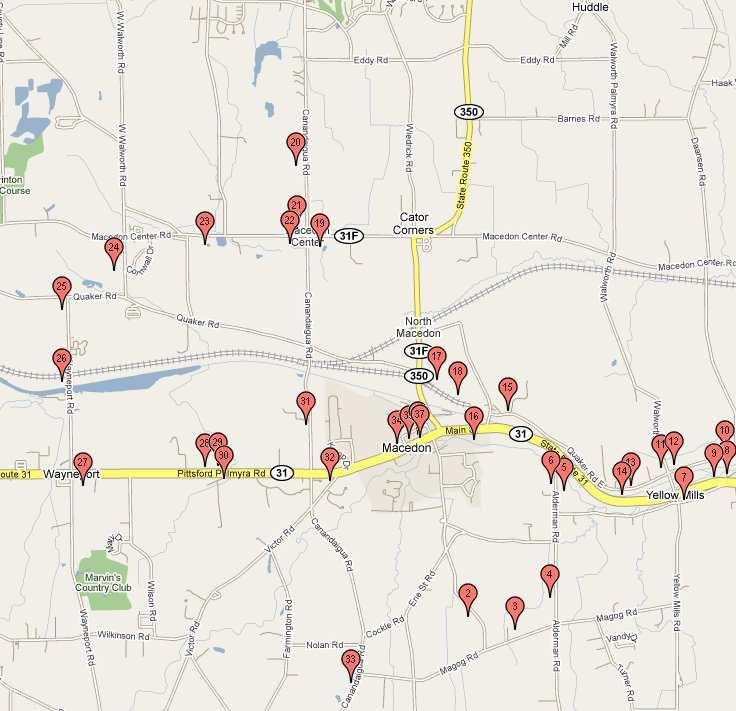
2 Please use caution and courtesy when touring the area. Use flashers and please do not interrupt home owners. This is a driving tour. Every attempt has been made to validate the accuracy of this information. If you have information regarding Historical Homes and Sites in Macedon, please drop a note to the Macedon Historical Society, PO Box 303, Macedon, NY The Historical Society would be glad to hear from you and add your information to the collections. For more information go to Start the tour in Macedon Village. Drive safely; you may want to put your flashing lights on when slowing down to view the stops. From the intersection of Routes 350 and 31, turn south on Erie Street: 1. The Macedon Village Cemetery began at this site in 1851, a gift of two acres from John Lapham. As was the Victorian rural cemetery fashion, cemeteries Former Bank, Currently Village Hall were located away from the centers of population, had a hilltop view, and were landscaped with natural plant materials. Families were buried together, often with a central family monument surrounded by individual gravesites. Before town parks were established, cemeteries were a place to visit, picnic, and bring out of town guests. The earliest burials were on the west side of the cemetery. Bear left on Lawrence Road. Around the bend of the road, there is a large white farmhouse on the right: 2. The house was built in 1813 by Ephraim Lapham, and soon became Lawrence Farm. Walter Lawrence Sr. had moved his family to Farmington from Mt. Pleasant, NJ, where he d made his living as a carpenter. They traveled by open wagon. Soon he moved to this site in Macedon where he took up farming. Walter Lawrence Jr. was the sixth born, and continued the family farm. The 89 acres were planted with fruit and hops. On the left side of the road was an apple dry house and a hop drying shed. Drying was the primary means for preserving food; the canning process wasn t discovered until Turn left onto Magog Road at the end of Lawrence Road, and drive east: 3. The Magog area has Macedon s most productive farm land. Rich muck land lies to the west and in smaller pockets. During Macedon s early days, the Magog muck land grew large quantities of celery, potatoes, onions, and other root crops for shipment, mostly to New York City. Turn left on Alderman Road: 4. Down the hill on the left side, the small stucco-faced house that sits close to the road, was District #1 school. The one-room school was built of stone in the mid-1800s. 5. Almost a mile further north on Alderman Road, there is a cobblestone home on the right in Greek Revival style. It was built in by David Warner. The house originally had 5 fireplaces. The barn is original, with hand-hewn beams, rough timbers and wide plank floors. 6. Across the street from the cobblestone house is a large brick Federal style house up on the hill. It was erected by Jonathan Briggs as an inn around Turn right onto Rte 31 going east. At this point Rte 31 is following the path of the old Rochester, Syracuse and Eastern line, which took passengers between towns and to Rochester. Then, the primary east-west highway was Quaker Road, which is later on the tour. 7. Just before approaching Yellow Mills Road, on the right, sat the Yellow Mill. It was the site of several grist mills over the years. The first was erected about 1795 by General John Swift. Early millers were Aaron Reed and John Willits. The mill was painted yellow and built out over the creek, which supplied water to drive the vertical water wheel. The dam was on the east side of the bridge. The mill burned to the ground July 19, Page 2 of 9


 opened in 1918, and made this area into a spillway for Lock #29.")
3 Continue on Route 31. Turn left across Route 31 into Aquaduct Park. Park your car in the lot to the right: 8. Dating from 1858, the Aldrich Towing Path Change Bridge is the oldest iron bridge in New York State, and one of only two bridges known to survive from the first enlargement of the Erie Canal. The bridge has a fascinating history, first serving the Canal in one location, then being moved when the canal was expanded. From , it was used by a local farmer to cross Ganargua Creek, and ultimately collapsed. It was restored and moved to this location in There is much more information about the bridge on the kiosks around the park. The stone aquaduct is on the west side of the park, and accessible on foot: 9. The Stone Aquaduct, was built in 1856 as part of the expansion of the Erie Canal. It carried the Erie Canal over Ganargua Creek, locally known as Mud Creek. The arches carried the towpath, still in use today as a trail. A wide wooden trough (a canal prism ) supported by the still-visible pillars of granite blocks, contained the water. The Barge Canal (the current Erie Canal) opened in 1918, and made this area into a spillway for Lock #29. Driving out of the park, turn right/west on Route 31, then right at the next intersection, onto Walworth Road. Over the onelane bridge, turn right onto Quaker Road, and look to the left after a half mile: 10. Tamerlayne is a classic cobblestone house in the Federal style. The right side of the house was built in 1827; the left side in the 1840s. The English style barns and homestead still appear as they did in the late 19 th century, when it was a working farm belonging to William A. Chapman. The farm was known for its sheep. Return back to Walworth Road, and turn right/north, stopping at the second house on the left, with the historical marker in front: 11. This building was District school #6, a one room schoolhouse, subsequently became a private dwelling. Prior to this, between 1809 and 1835, the Macedon Baptist Church was located on this site, before the church building was moved to Macedon village in 1835, and still stands as an active church. Behind this house are the Baptist Burying Grounds, which are maintained by the town. Access is on a path leading from the historic marker. Buried here are four pioneers of note: Hannah Harwood, d. April 14, 1815, the first woman to brave the Macedon wilderness with her husband, Webb; Lemuel Spear, d. Aug 3, 1809, who was the founder of the Macedon Baptist Church; Anna Wilcox, d. Dec 28, 1813, and her husband David Wilcox, d. Aug 23, As it looks today Anna and David Wilcox were the great, great-grandparents of Winston Churchill, prime minister of England during WWII. 12. Across the street from the schoolhouse, on the east side of Walworth Road, is an Italianate brick house built by James Kent around It is still a single family residence. Turn around, and go right/west on Quaker Road. There is a house with front pillars close to the road: 13. This house was built by Abraham Spear in the early 1830s, and was used as a tavern in the days when stage coaches traveled Quaker Road east and west as the main highway, long before Route 31. Page 3 of 9

4 Proceed to #2398, you will see a blue and gold marker on the left: 14. To this site Lemuel Spear, with his wife Ruth and nine children, came by covered sleigh from Cummington MA in February They purchased 500 acres from Isaac Hathaway for cents per acre. They brought 2 oxen along with some cows and sheep. They lived in the sleigh and a small hut until a log house could be built. Later, around 1800, the frame house of 17 th century New England pioneer chimney design was built. This house remained until The first meetings of the Macedon Baptist Church took place at the Lemuel Spear home, until a meetinghouse was erected on the site of District School # Historic Quaker Road, also known as the road to Rochester, was the location where our first pioneer family, Webb and Hannah Harwood and their children, settled. There is a historical marker in front of the Harwood site further west on Quaker Road; none of the structure remains. Take Quaker Road to O Neil Road. Quaker Road was rerouted with the expansion of the plant, and picks up again off Rte 350. Across O Neil Rd, sections of the old canal bridge are visible before turning left onto O Neil Rd. Go over the bridge, and turn right onto Rte 31 going west. 16. Gravino Park, on the left side of Rte 31. Joseph Gravino, spearheaded the development of this park in the early 70 s. Joe felt there was a strong need in the community for a place for families to go and socialize. The Park was originally named after Howard Samuel, President of Kordite that is now Pliant. Mr. Samuel pledge to donate money for the Park, so it was named after him. When Mr Samuel died the Park was named after Joe Gravino for his dedication to the community and country. Joe Gravino owned and operated a grocery store in the village in the building that is now the American Legion Hall. Mr. Gravino was one of the most decorated WWII veterans in New York State. Turn right onto Rte 350: The first (small) bridge spans the original Erie Canal bed, from around The stone sides of the old canal can still be seen.. The second bridge is over the present, or Barge Canal, dating from the early 20 th century, 1918 at latest. The Barge Canal was subsequently renamed the Erie in honor of the previous canals. Crossing the railroad tracks of the old West Shore RR line (which are still in use), there is a small sign, St. Patrick s Cemetery on the corner of the side road on the right. Turn right. 17. St. Patrick s cemetery dates from It is Macedon s best example of that Victorian rural cemetery style, with Catholic families of St. Patrick s interred in a terraced, park-like setting up into the woods. 18. At the end of the road to St. Patrick s cemetery, there are rail facilities which were formerly the Macedon Terminal of the West Shore Railroad. The passenger station is closest to you, and the freight house in the rear. Up to Macedon Center Road, and turn left. This intersection was known in the early 20 th century as Cator Corners, as the Cators owned the house on the northeast corner. Page 4 of 9 Entering Macedon Center, once known as Macedon Centre, proceed up the road toward the intersection at the top of the hill. 19. On the left, before the intersection with Canandaigua Road, is the only surviving Quaker Meeting House left in Wayne County. This was the second home to the Orthodox Quakers, built in The old Quaker Burying Ground is just to the east of the building. The first burials were made around 1820, and include pioneers of Macedon such as Jonathan Ramsdell ( ), Alexander Purdy ( ), and Philander Packard ( ).


5 The Macedon Grange #326 bought the building and met here for about 70 years. On the corner of the lot is the Temperance Monument, originally erected at the Macedon Center and Canandaigua Roads intersection on July 4, Ira Lapham had ordered a marble monument which was brought from Connecticut. The Temperance movement was an anti-alcohol movement, and the monument is inscribed Total Abstinence, This is the second monument, the original being buried beneath the relocated replacement, after being destroyed by a car running into it at the intersection. Proceed north on Canandaigua Rd to Macedon Center Cemetery 20. Macedon Center Cemetery was begun as a half-acre burial ground on the farm of Granville Wolsey around 1851, and Mrs. Wolsey was the first interment. The oldest section lies to the north. In 1850, the state passed a law prohibiting burial on farms. Artenas Ward, d. Feb 12, 1825, and a few others were removed from the burying ground on the Ward farm to this site. The nearest burial ground had been at the Friends (Quaker) Church at Macedon Centre. In February 1863, the Macedon Centre Cemetery Association began, by acquiring the Wolsey Burial Ground. The association added adjoining land, and saw to its maintenance. The association is still active and maintaining the cemetery. Walking around the cemetery, note the circular arrangement of the family plots of the Durfees and the Carmens, as well as some of the detail of the 19 th century stones and monuments. Turn back up Canandaigua Road, and turn right/west on Macedon Center Road: 21. On the right is the Macedon Academy, currently home to the Macedon Historical Society. The Society dates back to 1894, when it was organized by Charles Packard. The Macedon Academy was formed to serve an intermediate level, between the common school and the college, for the education of both sexes, says its 1842 Charter. More than 3000 students, local and from out of town, attended the school between 1842 and The original school building had been the Macedon Centre House, sometime referred to as the Hollister House, on the northwest corner of Route 31F and Canandaigua Road. It was used by travelers passing through this area until the Erie Canal opened, and Macedon Centre was bypassed. The Temperance movement had reduced the use of alcoholic beverages, and the tavern became available. An act of the legislature incorporating the Academy was passed April 11, 1842 through the influence of Durfee Osband, who had been a member of the New York State Assembly, and a Macedon Centre resident. The school operated in the tavern room the first year. The present building was erected in Across the street and just west of the Academy, is the United Methodist Church, on a site donated by Durfee Osband, and funded by money raised by subscription to the congregation. Built in 1847, the church was remodeled in Proceed west to the brick house on the left, Alpco Recycling: 23. This Italianate brick house was built in the 1860s by Steven Durfee. Page 5 of 9


6 Continuing west, turn left onto Wayneport Rd: 24. The Packard Valley Farm lands are to the right, and have been farmed by the Packard family since The farm was awarded Century Farm status by New York State in 1977, for having been in the same family for over 100 years. Their ancestors arrived in Macedon in February 1792, and pioneered their first farm south of here. Original Packard Home 1800 s Turn right on Quaker Road, and then left on Wayneport Road: 25. On the right, there is a fenced-in cemetery, the Wayneport Union Burying Ground, with a historical marker by the road. In 1833, a half-acre was deeded for $12.50, and this cemetery served West Macedon. The marker reads: In remembrance of the 26 Erie Canal laborers buried here, stricken in They built the longest canal, with the least experience, for the most public benefit. That quote is from the Erie Canal opening celebration remarks in 1825, but was used aptly for this marker. During the construction of the Enlarged Canal, there was a smallpox epidemic; some historical accounts say that these victims were predominantly Irish immigrants. It is the only known site where canal laborers were buried in a mass gravesite. The actual mass gravesite is unmarked, but this marker, donated by people who cared, remembers this event. 26. Wayneport, once known as West Macedon, stretched between the burying ground and Route 31. Its center was the canal and the railroad. The West Macedon Post Office opened in 1856, and burned down Nov 15, The New York Central Railroad (NYCRR) had a large refueling area here for steam engines. It was the main fueling area between New York City and Chicago. The 20 th Century Limited was the elite express train between these two cities. The train didn t stop in Rochester but it always stopped at Wayneport for fuel. There was a passenger station for West Macedon. The NYCRR iced and re-iced refrigerator cars here as well. For example, celery was raised on the Magog muck lands, harvested into field crates, and transported to the packing house. The packing house washed, trimmed and packed the celery in shipping containers. The crates of celery were loaded into railroad cars, which had ice bunkers in each end of the car. The doors for the ice were on the top. During travel the doors were held open at an angle. This scooped air down through the ice bin, forcing the refrigerated air through the stacked celery, preserving its freshness. Most of the cars used locally were owned and maintained by the Merchants Dispatch Company in Buffalo, NY. At the intersection of Wayneport Road and Route 31, turn left on Route 31 and pull over: Wilber Home burned in the 1930 s 27. The first frame house in Wayne County was built on a site immediately behind the building on the southeast corner, by Henry Wilbur III some time after Wilbur operated a grist and saw mill on Ganargua Creek across the county line in Farmington. The house burned in the 1930s Continuing east on Route 31, past Wal-Mart on the left: 28. At #815 Route 31 sits the Beal house. The house, of Greek Revival style, was built in from timber cut on the farm. It is still occupied by descendants of that family. Page 6 of 9


. Return to Route 31, turning right/east.")
7 29. Next door at #873 is the Delano house. It was built in 1850 by the Beal family on a 5 acre plot taken from their farm. It sets back from the road, and has white siding on the front. Turn right on Beebe Road: 30. Beebe Road was a portion of the right of way for the Rochester Syracuse and Eastern Railroad. The road was named after Clifford D. Beebe, the owner of the Trolley, who built a syndicate of 12 transportation lines. The Trolley as it was called, provided a double-tracked interurban service between Rochester and Syracuse. The road opened in sections, with the 12 mile section between Newark and Macedon on July 2, At the end of the road on the right, the brick substation, designed by Scheaff & Jaastad of Boston, reduced 33,000 volt AC 3 phase 25 cycle power to 550 volt DC. The railroad ceased operation in 1931 due to high operational losses (and perhaps the Depression!). Return to Route 31, turning right/east. Turn left on Canandaigua Road, and drive about a half mile: 31. The Charles H. Bullis house was built in It is a cobblestone house with brick corners, on the left side of the road in an old time setting. A previous Macedon historian, Mildred Airy, had said that the wooden addition in the rear was originally built for a labor camp during the digging of the Erie Canal, and later moved to this site. Bullis Park, immediately next door, was donated to the town by the Bullis Estate. Turn around at Bullis Park, and drive south on Canandaigua Road, to Route 31. Turn left on Route 31, and slow down before Victor Road on the right, before McLouth Chevrolet. Turn right onto Victor Rd: 32. Just past the right at the corner of Route 31 and Victor Road is a red barn, which was part of an early foundry on the site. This foundry was the beginning of what was to become the famous Bickford and Huffman Company, known nationally for their innovative grain drills. This area was known as The Huddle and was the center of Macedon commerce until the Erie Canal opened here in Businesses then wanted to be near the canal locks, and as they moved closer, Macedon village was formed. For an optional stop at a unique cobblestone home (stop #33), continue on Victor Road and turn left onto Canandaigua Road, at the flashing red light and drive 2 miles, to where Magog Rd meets Canandaigua Rd. Otherwise turn back on Victor Rd and proceed into the Village on Rte The house at #815 Canandaigua Road is a cobblestone with a unique gable front, built in by John and Elizabeth Baker at the cost of $2000. The cobblestones were hauled from Lake Ontario by ox cart. It remained in the Baker family until The home is on the National Register of Historic Places. After viewing this stop, turn back Canandaigua Rd toward the village/rte. 31. Proceed on Rte 31 toward the village. The village was incorporated in November Enoch Gannett and Abiatha Powers had paid 18 ¾ cents per acre for the land, and in 1828 they sold it to William Willits, Alexander Purdy, and John Lapham. Page 7 of 9


8 34. On the left just before the corner of West Street is the John Lapham house, it can be imagined how grand this house and property must have been. The house dates from the 1860s. 35. On the left, St Patrick s church, built 1957, though the congregation was begun in Macedon in Their first church building was further east in the village, and in 1877 it had over 700 members. 36. Also on the left, the grand Bickford Home, built in Now a veteran s home, was actually the residence of Henry Huffman, co-founder with Lyman Bickford of the Macedon Agricultural Works, which became Bickford and Huffman Co. 37. Next to the Bickford Home is the Macedon Baptist Church, which was moved from the site at Quaker and Walworth roads in 1835, and celebrated its 200 th anniversary in This 40' by 50' church building was originally built at the corner of Quaker and Walworth Roads in 1809 (historical marker). It was "pulled down" in 1835 and moved to Macedon Village, where today the hand-hewn beams of old hold it up. The church body itself was formed nine years earlier at the home of Lemuel Spear on Quaker Road (historical marker). For 209 years, the membership has experienced many triumphs and several failures, and continues to be justifiably proud of its heritage. The rich history of The First Baptist Church of Macedon is captured in a book published for the bicentennial, A HISTORY OF THE FIRST TWO HUN- DRED YEARS. It is available in the public library as well as the church We hope you have enjoyed this Driving Tour, and that it has sparked some deeper interest in Macedon history. Any questions or comments can be directed to the Macedon Town Historian at or Do you own a Historical Home in Macedon? The MHS and the Town Historian would like to learn about your home. There are many more homes in the Macedon Township that are over 200 years old. Another segment of the Driving Tour will be available this summer and will be available at the Macedon Village and Town Halls, Macedon Public Library and the Historical Macedon Academy. You will also be able to download a version at the website, The Macedon Historical Society is always looking for new members. Please send a note to MHS, P O Box 303, Macedon, NY and an application will be sent to you. MHS is always looking for more history of our community. Please send it along. Special Thank you to The Town of Macedon Historian and Waste Management of NY for assisting in defraying the cost of printing. Page 8 of 9
9
TOWNSHIP OF HILLSIDE, NJ.
 TOWNSHIP OF HILLSIDE, NJ. HILLSIDE Formed as Township: 1913 1970 Population: 21,636 Land Area 2.70 square miles The initial settlement of the township now known as present day Hillside followed shortly
Hudson Valley Vernacular Architecture Dutch Barn Preservation Society Field Trip to the Palatine Region of the Mohawk Valley May 18, 2013
 Hudson Valley Vernacular Architecture Dutch Barn Preservation Society Field Trip to the Palatine Region of the Mohawk Valley May 18, 2013 Trip Schedule Site Arrive Depart Old Palatine Church 10:30 am 11:15
Cranberry Lake Farm. By Alicia McCullough for the Oakland Township HDC
 Cranberry Lake Farm By Alicia McCullough for the Oakland Township HDC Cranberry Lake Farm s History Cranberry Lake Farm was purchased by Seymour Fletcher in 1837 from the Federal Government. The development
First Floor Plan. Second Floor Plan
 The Flint Homestead was built by 1709 for Ephraim Flint (1641 1723) and his wife Jane Bulkeley. They did not have any children. In 1723 he willed his mansion house to his nephew, John Flint, and to John
EGYPT HISTORIC DISTRICT
 EGYPT HISTORIC DISTRICT Cyrus Packard s Tavern The Early Years The hamlet of Egypt has been a part of Perinton since the 1790 s, which qualifies it as one of the town s oldest settlements. In a certain
Mankato s Transportation Heritage
 Mankato s Transportation Heritage City of Mankato Mankato Heritage Preservation Commission May 11, 2017 1. Union Depot, 112 S. Riverfront Drive, c. 1896. The railroads were Mankato s dominant transportation
Family Fun Summer. Challenges in Albion!
 Family Fun Summer Challenges in Albion! Dear Parents, Your children have been learning about fun facts that make Albion AMAZING! This booklet shares the facts with you along with some interesting challenges.
THE CORPORATION OF THE TOWN OF NIAGARA-ON-THE-LAKE. BY-LAW NO (214 Four Mile Creek Road)
") THE CORPORATION OF THE TOWN OF NIAGARA-ON-THE-LAKE BY-LAW NO. 4807-15 (214 Four Mile Creek Road) A BY-LAW TO DESIGNATE THE PROPERTY KNOWN MUNICIPALLY AS WOODBOURNE, 214 FOUR MILE CREEK ROAD, IN THE TOWN
THE CORPORATION OF THE TOWN OF NIAGARA-ON-THE-LAKE BY-LAW NO. 4807-15 (214 Four Mile Creek Road) A BY-LAW TO DESIGNATE THE PROPERTY KNOWN MUNICIPALLY AS WOODBOURNE, 214 FOUR MILE CREEK ROAD, IN THE TOWN
Turn right at Village St.
 A walk around MEDWAY VILLAGE National Historic District new hall was built in the Second Renaissance style and originally combined commercial uses on the first floor including a grocery and tobacconist,
BACKROADS BICYCLE/AUTOMOBILE TOUR OF MIDDLESEX, VERMONT
 BACKROADS BICYCLE/AUTOMOBILE TOUR OF MIDDLESEX, VERMONT (created and published by the Middlesex Historical Society) Welcome to a 25-mile self-guided historical tour of the backroads of Middlesex. You may
MEDFORD HISTORICAL SOCIETY 10 Governors Avenue, Medford, MA Medford Brick by Brick Walking Tour
 MEDFORD HISTORICAL SOCIETY 10 Governors Avenue, Medford, MA 02155 Medford Brick by Brick Walking Tour Tour Stops 1. Ship Memorial Riverbend Park Ship building began on Riverside Avenue, formerly known
CHRONOLOGY & DEVELOPMENT BOUDINOT-SOUTHARD PROPERTY BASKING RIDGE, NJ OF THE
 CHRONOLOGY & DEVELOPMENT OF THE BOUDINOT-SOUTHARD PROPERTY BASKING RIDGE, NJ Elias Boudinot 1740 Elias Boudinot born May 2 in Philadelphia, where his family was a neighbor of Benjamin Franklin. 1760 Boudinot
Rochester Avon Historical Society Research Reports
 Rochester Avon Historical Society Research Reports Research Report #9 Rochester Municipal Park (formerly Avon Park) March 2012 Rochester Avon Historical Society Rochester, Michigan www.rochesteravonhistoricalsociety.org
Heritage Caledon Walking Tour Series
 Heritage Caledon Walking Tour Series Terra Cotta Tour Please respect private property A brief history In 1822, Joseph Kenny was awarded a Crown Grant in Chinguacousy Township of 100 acres along the Credit
Society Member to Supervise the Building of James Monroe s Birthplace House Charles Belfield, a councilor of the War of 1812 Society in the
 Society Member to Supervise the Building of James Monroe s Birthplace House Charles Belfield, a councilor of the War of 1812 Society in the Commonwealth of Virginia has been designated as the supervisor
Langford Road, East Candia. East Candia. A Walking Tour. Published by Candia Heritage Commission September 2013
 Langford Road, East Candia East Candia A Walking Tour Published by Candia Heritage Commission September 2013 Methodist Church In 1894, the Methodist Society built a church at what is today 163 Langford
Geneseo, NY Main Street Walking Tour
 Geneseo, NY Main Street Walking Tour Geneseo's Main Street, which was listed on the National Register of Historic Places in 1977, extends approximately 4 blocks from the Çounty Court House to the Village
Walking Tour. A self-guided walk along the historic Blackstone Canal. Intro Walking Tour Directions. Water Powered! BlackstoneHeritageCorridor.
 Walking Tour Blackstone Canal Northbridge Uxbridge, MA Towpath Walk A self-guided walk along the historic Blackstone Canal. Intro Walking Tour Directions Cover photo: Oil Painting of Lady Carrington by
The Early Settlers Revised: September 7, 2013
 The Early Settlers Revised: September 7, 2013 The earliest settlers were farmers. Among the largest farmers in 1860 were: Adams, of which there were several, Phillips, Lynch, Avery, Gere, Garrett and Malloy.
History/Descriptive Notes: 3.5 acres with orchard that was actively used until current owner purchased in 1982.
 Address: 4395 McCandlish Road Tax Parcel Number: 12-22-200-031 Year Built: 1926 (per owner) Architectural Style: Craftsman Other Buildings/Features: garage (date unknown) 61 History/Descriptive Notes:
Address 347 Whitney Street. East elevation, camera facing southwest.
 FORM B BUILDING Assessor s Number USGS Quad Area(s) Form Number MASSACHUSETTS HISTORICAL COMMISSION MASSACHUSETTS ARCHIVES BUILDING 220 MORRISSEY BOULEVARD BOSTON, MASSACHUSETTS 02125 Town Northborough
HISTORICAL MARKERS issued by
 HISTORICAL MARKERS issued by INDIANA HISTORICAL BUREAU in MONTGOMERY COUNTY, INDIANA 2016 Compiled by Dian Moore, Montgomery County historian NUMBER NAME 54.1962.1 Lane Place 54.1963.1 Major General Lew
HISTORICAL PLAQUES IN HAMILTON TOWNSHIP. 1. Located In Gore's Landing in Pioneer Park. Bearing the Ontario Coat of Arms GORE'S LANDING
 HISTORICAL PLAQUES IN HAMILTON TOWNSHIP 1. Located In Gore's Landing in Pioneer Park Bearing the Ontario Coat of Arms GORE'S LANDING Named after Thomas S. Gore, an Irishman who settled in this vicinity
A History of West Chicago
 A History of West Chicago The Prairie Prairie Inhabitants Winfield Mounds Dickson Mounds, near Lewistown, in southern Illinois. An example of what Native burial mounds look like. First Permanent Settlers
Heritage Caledon Walking Tour Series
 Heritage Caledon Walking Tour Series Caledon Village Tour Please respect private property A brief history Caledon Village is located on Hwy. 10 at the centre of the former Caledon Township. The crossroads
Keeseville. A walk through historic. Words and pictures by Lee Manchester, Lake Placid News, October 8, 2004
 A walk through historic Keeseville Words and pictures by Lee Manchester, Lake Placid News, October 8, 2004 A group of about 30 tourists took a stroll last Thursday afternoon through the history of Keeseville,
Bike MS Ride, West Michigan Riding In Historical Allegan County
 Bike MS Ride, West Michigan Riding In Historical Allegan County The Michigan Chapter of the National MS Society would like to extend our gratitude to the Steering Committee for the West Michigan Bike MS
The Original Farm, Dairy & Sausage plant buildings
 The Original Farm, Dairy & Sausage plant buildings Featured below are images of the original Deerfoot farm buildings along Stony Brook. Beginning in 1894, the original farm buildings along with 20 acres
Hickman s (Diamond) Mills
 Mills") Hickman s (Diamond) Mills On the east branch of Naaman's Creek, near the northwest boundary of Lower (and Upper) Chichester townships, was the saw- and grist-mill of Samuel Hickman, which was one of the
Hickman s (Diamond) Mills On the east branch of Naaman's Creek, near the northwest boundary of Lower (and Upper) Chichester townships, was the saw- and grist-mill of Samuel Hickman, which was one of the
A Historical Timeline of Cedar Falls
 A Historical Timeline of Cedar Falls 1700-1750 The Meskwaki (Fox), after having been forced out of their former homes further east, move into the area by 1750. They are allied with the Sauk through language
HISTORIC RESOURCES OF IMPORTANCE TO THE TRAIL CORRIDOR
 Return to Appendicies Index HISTORIC RESOURCES OF IMPORTANCE TO THE TRAIL CORRIDOR DESIGNATION AS A NATIONAL AND STATE HERITAGE AREA A National Heritage Area is a place designated by the United States
Guide for 2018 Jackson Brigade Reunion Tour Written by Nancy Jackson, Last update July 24, 2018
 Guide for 2018 Jackson Brigade Reunion Tour Written by Nancy Jackson, Last update July 24, 2018 We will start from the "Super 8 by Wyndham Weston" motel parking lot Saturday August 4, 2018. Be there by
Cassadaga HISTORIC WALKING TOUR OF
 HISTORIC WALKING TOUR OF Cassadaga This tour was developed by Citizens for a Better Cassadaga, with the generous financial support of the Chautauqua County Health Network, as part of Creating Healthy Schools
Corridor Management Plan for Virginia Coal Heritage Trail WMTH Corporation, 2011, trailsrus.com
 CHAPTER IV: HIGHLIGHTS Along the The St. Paul loop travels over 80 miles through the counties of Russell, Scott, Lee and Wise before ending back at St. Paul. As noted earlier, St. Paul holds the distinction
HO, HO, HO, SAID OUR OPEN HOUSE VISITOR
 2013 HO, HO, HO, SAID OUR OPEN HOUSE VISITOR Feb 2&3, Great Train Expo, Timonium, MD Feb 23&24, Greenburg Train Show, VA Beach For more information on these shows - Google or go to http:// www.trainweb.org/
Loretta Welch. Yankee Doodle. copyright protected. Open Door
 Loretta Welch Yankee Doodle After studying in Trinity College, Dublin, and working in publishing in San Francisco, Loretta Welch landed in Boston s North End, steps away from the shore on which her immigrant
*** Note: Mileages are based on resetting trip odometer to zero at each turn point AL-5 is Alabama Highway 5 CO-51 is County Road 51, etc.
 Directions to Ham(m) Family Reunion site of Lester Ham s Original Homestead Owned and hosted by Jeff & Renee Hamm Comments & corrections to Marv Hamm: MarvHamm@aol.com Ham(m) Family Reunion annually on
Inquiry: Was It Destiny To Move West? Supporting Question 2: What new technologies influenced westward expansion?
 Inquiry: Was It Destiny To Move West? Supporting Question 2: What new technologies influenced westward expansion? Supporting Question 2: Directions: (1) Keep all papers organized and back in order after
INLAND STEEL COMPANY, INDIANA HARBOR WORKS PHOTOGRAPHS,
 Collection # P 0711 INLAND STEEL COMPANY, INDIANA HARBOR WORKS PHOTOGRAPHS, 1926 Collection Information 1 Historical Sketch 2 Scope and Content Note 3 Contents 4 Processed by Dalton Gackle July 2018 Manuscript
In 1850, Congress passed a law donating two and one half million acres to the State of Illinois for the use of the Illinois Central Rail Road.
 Merna The town of Merna was founded by primarily Irish and German farmers. Their faith and families were an integral part of who they were. There was and still is today a strong sense of community. Most
History Reclaimed: Authentic American Vintage Lumber from the Parker Dexter 1840 s Barn in Topsham, VT
 History Reclaimed: Authentic American Vintage Lumber from the Parker Dexter 1840 s Barn in Topsham, VT Immigration Thomas Dexter was born in England and immigrated to the New World in 1629 or 1630, bringing
Morgan s Vale and Woodfalls History Trail. (You could start at any point and follow the trail round)
") Morgan s Vale and Woodfalls History Trail (You could start at any point and follow the trail round) 1) MORGAN S VALE & WOODFALLS PRIMARY SCHOOL Built in 1869, it served as a church on Sundays until the
Morgan s Vale and Woodfalls History Trail (You could start at any point and follow the trail round) 1) MORGAN S VALE & WOODFALLS PRIMARY SCHOOL Built in 1869, it served as a church on Sundays until the
The First Private Railway Siding at Papanui.
 The for The First Private Railway Siding at Papanui. Tenders were accepted for the construction of the railway from Addington to Papanui in September 1870. The line was built out through the west of the
Walking Tour. America s first textile village. Intro Walking Tour Directions. Water Powered! BlackstoneHeritageCorridor.org
 Walking Tour slatersville North Smithfield, RI America s first textile village. Intro Walking Tour Directions Slatersville Congregational Church and Mill. Photo courtesy of the Blackstone Valley Tourism
Heritage Caledon Walking Tour Series
 Heritage Caledon Walking Tour Series Cheltenham Tour Please respect private property * Designated under the Ontario Heritage Act 1 14318 Creditview Road *Charles Haines House circa 1835 Constructed for
Late-nineteenth-century view of the Macy house on Liberty Street GPN2044. Nantucket Historical Association
 MACY-CHRISTIAN OLDEST HOUSE HOUSE Late-nineteenth-century view of the Macy house on Liberty Street GPN2044 10 Nantucket Historical Association MACY-CHRISTIAN» OLDEST HOUSE Macy-Christian House In the early
The Broad Street Park Quest
 The Broad Street Park Quest Claremont, New Hampshire Easy Architectural, Historical Pavement 1:00 To get there: This quest is in the center of Claremont s downtown and municipal area. It can be reached
Section 1: Vocabulary. Be able to determine if the word in bold is used correctly in a sentence.
 Section 1: Vocabulary. Be able to determine if the word in bold is used correctly in a sentence. Hardships: difficult conditions or situations that cause discomfort and/or suffering Pioneers: the people
Picture circa It has undergone an evolution of changes with some portions dating back to before 1739.
 The Town of Harwinton s Historic Districts and Historic Properties Commission is dedicated to encouraging the preservation of sites and buildings within the town and contributing to the educational, architectural
RAILROADS IN ACTON THE DEVELOPMENT OF A NEW ENGLAND TOWN. The Acton Historical Society The Friends of Bedford Depot Park.
 RAILROADS IN ACTON THE DEVELOPMENT OF A NEW ENGLAND TOWN The Acton Historical Society The Friends of Bedford Depot Park October 27, 2018 Acknowledgements Bill Klauer, Acton Town Historian Lisa Soo, Acton
Frederick County, MD Rural Roads Tour # 3
 Frederick County, MD Rural Roads Tour # 3 Unionville Loop Tour mileage: Approx. 63 miles Driving time: about 3 ½ hours (not including stops) There are 5 separate tours of Frederick County s Rural Roads.
Hunter Water S170 Register
 SHI No.: 3630112 Location Name: 800 Salisbury Rd, Munni NSW 2420 Other ID nos HW ID: 130. Description: The house is set on a buff over looking the creek The house is built in the colonial style, single
Cherokee And The Concow Dam
 Cherokee And The Concow Dam In 1853 Sol Potter, a school teacher from the Cherokee Nation in Oklahoma along with several students discovered gold in Butte County and named the area Cherokee. Others soon
24 EARL STREET WALKING TOUR
 24 EARL STREET WALKING TOUR This walk covers four city blocks of Earl Street, one of the oldest streets in Kingston. APPROXIMATELY 45 MINUTES Please be respectful of private property. 24 EARL STREET WALKING
Alvin Clark. Pioneer of compiled by Stephenie Flora oregonpioneers.com
 Alvin Clark Pioneer of 1852 compiled by Stephenie Flora oregonpioneers.com Alvin Clark [Pioneer of 1852] b. 17 May 1805 New York 25 Aug 1880 Brush Prairie, Clark County, Washington buried Brush Prairie
Barbee-Hargrave Cemetery
 Barbee-Hargrave Cemetery [Image: Barbee-Hargrave Cemetery Plaque, courtesy of Preservation Chapel Hill] Location and Land Ownership The Barbee-Hargrave Cemetery is located near the Greenwood subdivision
Land Distribution. Land Purchases. 14 The Nature of Settlement: Post-Revolution to the Civil War Changing Shape of New York
 14 The Nature of Settlement: Post-Revolution to the Civil War 1780-1865 Prof. Anthony Grande Geography Dept. Hunter College-CUNY Spring 2018 Settlement Sequence: State of New York Revolutionary War ends
THE CAMPBELLS FROM COUNTY CAVAN - Ulster Scots who settled in Canada * By Brian McConnell
 THE CAMPBELLS FROM COUNTY CAVAN - Ulster Scots who settled in Canada * By Brian McConnell In the cemetery beside the United Church at Little Britain, Ontario, now stands an impressive eight foot stone,
APPENDIX K: BUILT HERITAGE AND CULTURAL HERITAGE LANDSCAPES
 APPENDIX K: BUILT HERITAGE AND CULTURAL HERITAGE LANDSCAPES TABLE 1: Built Resources (BHR) and Cultural Heritage Landscapes (CHL) Within and Adjacent to the West Whitby Secondary Plan Area Site # 1. CHL
Bikes talk to each other like dogs, they wag their wheels and tinkle their bells, the riders let their mounts mingle.
 Bikes talk to each other like dogs, they wag their wheels and tinkle their bells, the riders let their mounts mingle. Daniel Behrman, The Man Who Loved Bicycles W hitmore Lake Loop route: Dexter, the corner
Seaforth Walking Tour
 Seaforth Walking Tour 1: Victoria Park The land for Victoria Park was donated to the Town by Dr. William Gouinlock in 1875, (one year after Seaforth was officially incorporated). The bandshell was constructed
Charles Pillsbury Allen House
 Charles Pillsbury Allen House 1380 Rocky Lake Drive circa 1847 In 1831, Charles Pillsbury Allen (1805-1862) started his Chair and Bucket Manufactory in Fall River. In 1847, Mr. Allen (1805-1862) bought
DOWNTOWN WALKING TOUR CIRCLEVILLE, OHIO
 DOWNTOWN WALKING TOUR CIRCLEVILLE, OHIO Court & Main Street to Mound Street, to Scioto Street and back to Main & Court and on to High Street for a final stop at Wittich s. Compiled by W. W. Higgins & the
Francis Family Bus Tour July 16, 1999
 Francis Family Bus Tour July 16, 1999 Thank you for joining us. We have prepared a brief synopsis of the points of interest that we will see today. We are pleased to have Earl and Marjorie Lindsay along
March (Information collected from ltihistoricalsociety.org. Image courtesy of the Leeds and Thousand Islands Archives)
") March 2017 DATE POST IMAGE 1 Pictured below is the Brady Barn. This timber frame barn was built on Berryton Road in the 1920's. The timbers were sawn rather than hewn, but the finishing and assembly of
March 2017 DATE POST IMAGE 1 Pictured below is the Brady Barn. This timber frame barn was built on Berryton Road in the 1920's. The timbers were sawn rather than hewn, but the finishing and assembly of
2018 The Friends of Two Rivers Mansion, a 501(c)(3) organization McGavock Pike,
(3) organization McGavock Pike,") NEWSLETTER Number 42 May - June 2018 The Friends of Two Rivers Mansion, a 501(c)(3) organization 3130 - McGavock Pike, President Larry Weber's Remarks - With summer around the corner, let s get ready to
NEWSLETTER Number 42 May - June 2018 The Friends of Two Rivers Mansion, a 501(c)(3) organization 3130 - McGavock Pike, President Larry Weber's Remarks - With summer around the corner, let s get ready to
Subject(s): Century II (aka Auditorium, Cultural Center, Civic Center, Civic Cultural Center)
: Century II (aka Auditorium, Cultural Center, Civic Center, Civic Cultural Center)") Tihen Notes Subject Search, p. 1 Dr. Edward N. Tihen (1924-1991) was an avid reader and researcher of Wichita newspapers. His notes from Wichita newspapers -- the Tihen Notes, as we call them -- provide
Tihen Notes Subject Search, p. 1 Dr. Edward N. Tihen (1924-1991) was an avid reader and researcher of Wichita newspapers. His notes from Wichita newspapers -- the Tihen Notes, as we call them -- provide
BIRDING Lake Fayetteville
 BIRDING Lake Fayetteville Lake Fayetteville is an impoundment of Clear Creek, created as a water supply for Fayetteville in 1949. With development of other water supplies, especially Beaver Lake, Lake
GRAVE OF EVA AMELIA HEWITT MUNROE
 GRAVE OF EVA AMELIA HEWITT MUNROE Adjacent to 2875 Me FARLANE ROAD october 6, 2009 Historic and Environmental Preservation Board City of Miami GRAVE OF EVA EMELliA HEVV~TT MUNROE ADJACENT TO 2875 MCFARLANE
Black Hill Regional Park, Little Seneca Lake
 Black Hill Regional Park, ittle Seneca ake ittle Seneca ake, in Black Hill Regional Park, is a reservoir created after a previous drought struck the Washington area. The park is under Maryland-National
illing Era power for our society, in this age of alternate forms of energy, falling water may seem like a quaint old-fashioned way to power a mill.
 Saint Anthony Falls Historic Walking Tour The tour starts at the Father Hennepin Park sign shown below, a half block south of the intersection of SE Main Street and SE 3 rd Avenue on the east side of the
MEDIA ADVISORY. FOR IMMEDIATE RELEASE November 12, 2012
 MEDIA ADVISORY FOR IMMEDIATE RELEASE November 12, 2012 Niagara-on-the-Lake On Monday, November 19, 2012, the Lord Mayor and members of the Town s Municipal Heritage Committee and War of 1812 Bicentennial
League of Michigan Bicyclists Cross State Route LENAWEE COUNTY
 League of Michigan Bicyclists Cross State Route LENAWEE COUNTY History & Geography: Lenawee County got its start when 30 people arrived from Jefferson County, New York and settled along the Raisin River
Some History of Glasgow Cemeteries
 Some History of Glasgow Cemeteries W. Samuel Terry IV During a recent gathering of a public body some questions regarding the history of the Glasgow Municipal Cemetery were posed. This article will present
A Stroll Around Crystal Lake. Newton History Museum
 A Stroll Around Crystal Lake Newton History Museum A Stroll Around Crystal Lake June 2006 Produced by Newton Historical Society Board Member Lucy Caldwell-Stair, using the archives of the A Stroll Around
The Tanska Resort and Family Tanska Auto Camp
 The Tanska Resort and Family Tanska Auto Camp The Tanska Auto Camp was an early twentieth-century retreat located on the northwestern shore of Pine Lake on the Sammamish Plateau (King County), operating
THE EPHRAIM ALEXANDER McAULEY HOUSE
 THE EPHRAIM ALEXANDER McAULEY HOUSE This report was written on October 1, 1999 Special Note: The Historic Landmarks Commission moved the McAuley House to a site on the Huntersville-Concord Road in 2008.
A Note from the President
 Volume 37, Issue 1 www.stowhistory.org March 2015 2015 Officers John Baranek President 330-688-9381 jbaranek@stow.oh.us shs@stow.oh.us John Daugherty Vice President 330-730-5107 jhdaugh@aol.com Marcia
STREET STATEMENT OF SIGNIFICANCE MARCH 2017
 1195 12 TH STREET STATEMENT OF SIGNIFICANCE MARCH 2017 HISTORIC CONTEXT The Rush House is located in the historic Ambleside neighbourhood of West Vancouver. Due to its position along the Burrard Inlet,
DESIGNATION REPORT KENNEDY-BAKER-WALKER-SHERRILL HOUSE (1849) 9320 KINGSTON PIKE (CLT ) KNOXVILLE, TENNESSEE July 12, 2007
 9320 KINGSTON PIKE (CLT ) KNOXVILLE, TENNESSEE July 12, 2007") DESIGNATION REPORT KENNEDY-BAKER-WALKER-SHERRILL HOUSE (1849) 9320 KINGSTON PIKE (CLT 132-027) KNOXVILLE, TENNESSEE July 12, 2007 Description The Kennedy-Baker-Walker-Sherrill House is located on the south
DESIGNATION REPORT KENNEDY-BAKER-WALKER-SHERRILL HOUSE (1849) 9320 KINGSTON PIKE (CLT 132-027) KNOXVILLE, TENNESSEE July 12, 2007 Description The Kennedy-Baker-Walker-Sherrill House is located on the south
THE FORMER BRADBURY HALL, CHATSWORTH ROAD, CHESTERFIELD. GROUP LEADER, DEVELOPMENT MANAGEMENT
 AGENDA ITEM NO. 7 THE FORMER BRADBURY HALL, CHATSWORTH ROAD, CHESTERFIELD. MEETING: PLANNING COMMITTEE DATE: 17 TH MAY 2004 REPORT BY: WARD: COMMUNITY FORUM: GROUP LEADER, DEVELOPMENT MANAGEMENT HOLMEBROOK
The Birth of Grand Lake St. Marys
 The Birth of Grand Lake St. Marys Several publication excerpts below detail the birth and history of Grand Lake St. Marys. Special thanks to George Neargarder for providing the articles, images and expertise.
Commonwealth of Massachusetts Massachusetts Historical Commission 220 Morrissey Boulevard, Boston, Massachusetts
 Inventory No: Historic Name: Common Name: Address: HRV.165 Blood, Joseph House Farnsworth, Jonathan - Beaman, Jonathan House 74 Poor Farm Rd City/Town: Village/Neighborhood: Local No: 9-17 Year Constructed:
Walking Tour GREAT ROAD
 Walking Tour GREAT ROAD lincoln, RI Travel through three hundred years in three miles. Intro Walking Tour Directions Moffett Mill. hoto courtesy of Blackstone River Valley National Heritage Corridor Water
Fall Member Trip Historic New York City and the Hudson River Valley September 24-29, 2018
 Fall Member Trip Historic New York City and the Hudson River Valley September 24-29, 2018 Day 1: Monday, September 24 - Preview to the Hudson River Valley Enjoy the scenic views as you travel up the Hudson
Redsecker Residence: 244 South Market Street; Elizabethtown, Pennsylvania
 Hon 170: Elizabethtown History: Campus and Community Joseph Santos Professor Benowitz 5 May 2017 Redsecker Residence: 244 South Market Street; Elizabethtown, Pennsylvania Abstract: The Redsecker Residence,
Boll s Brewhouse: 45 North Market Street, Elizabethtown Pennsylvania
 Hon 170: Elizabethtown History: Campus and Community Joseph Santos Professor Benowitz 5 May 2017 Boll s Brewhouse: 45 North Market Street, Elizabethtown Pennsylvania Abstract: Henry Boll s Brewery operated
September 24, :43 PM THEMED SCHOOL FIELD TRIPS PIONEER INDIANA
 September 24, 2015 2:43 PM THEMED SCHOOL FIELD TRIPS PIONEER INDIANA Gallery PIONEER INDIANA Using the galleries and public spaces of the Indiana State Museum, answer the following questions. Q: If pioneer
Cobblestone Buildings in Seneca County
 Cobblestone Buildings in Seneca County There are at least twelve cobblestone structures still in use in Seneca County today. Using an Ice Age residue of glacially-rounded native stones, pioneer craftsmen
L 6-1. gister of Cultural Heritage Resources Brramalea Road Crawford Hou
 L 6-1 Municipal Reg gister of Cultural Heritage Resources Listing g Candidate Summ mary Rep port Brampton Heritage Board Date: June 24, 2014 9050 Brramalea Road use Crawford Hou Ju une 2014 L 6-2 Property
LOG CABIN (Now at Fiddler s Grove, Lebanon, Tenn.)
") LOG CABIN (Now at Fiddler s Grove, Lebanon, Tenn.) Property and Cabin first owned by Gleaves Family and probably constructed by them John Donelson of the County of Tennessee 640 acres - $600 written 1/11/1796
LOG CABIN (Now at Fiddler s Grove, Lebanon, Tenn.) Property and Cabin first owned by Gleaves Family and probably constructed by them John Donelson of the County of Tennessee 640 acres - $600 written 1/11/1796
St. Augustine Self-Guided Walking Tour
 ... The following is a PREVIEW SAMPLE of the St. Augustine Self-Guided Walking Tour Please purchase, download and print the rest of the St. Augustine Walking Guide Series by visiting: www.citywalkingguide.com/staugustine
Type of Building. By-law
 1 2-2-storey frame house on stone rubble foundation. - Built by Mead - "Ontario " plan. - Centred gable with arched window in gable. Meads 202 John Plan 20, Part Lot 20 1895 Residence - Shutters on the
= Stops. = Restrooms
 = Stops = Restrooms Restrooms are located near the Lake Elkhorn pavilion Safety Tips 1.Be courteous. 2.Travel at a safe speed. 3.Use your bell or announce: passing on your left. 4.Remember there are people
Yankee Hill Dispatch
 Yankee Hill Dispatch Vol 2 No 3 Dec 2008 Published by the Yankee Hill Historical Society www.yankeehillhistory.com P.O.Box 4031, Yankee Hill, Ca 95965 Wishing You Happy Holidays And A Prosperous 2009 Our
marsden jazz festival 25 years of jazz in the yorkshire pennines village trail
 marsden jazz festival 25 years of jazz in the yorkshire pennines village trail Launched in 1992, with the objective of utilising the refurbished Mechanics Hall and to contribute to the regeneration of
Walking Horace Greeley s Farm A New Castle Historical Society Project
 Walking Horace Greeley s Farm A New Castle Historical Society Project A Brief History of Horace Greeley s Farm Horace Greeley, publisher of the New York Tribune, and later a candidate for President of
Bicentennial Notes about Olmsted Falls and Olmsted Township First Farmed in 1814 and Settled in 1815 Issue 26 July 1, 2015
 Olmsted 200 Bicentennial Notes about Olmsted Falls and Olmsted Township First Farmed in 1814 and Settled in 1815 Issue 26 July 1, 2015 Contents The Depositors Building Was a Renovation Challenge 1 New
Lane Head, St James Square & Bridge Street
 Lane Head, St James Square & Bridge Street Standing at the junction of Lanehead Lane was one of Bacup s oldest hostelry s when it was demolished in 1931, the Angel Inn Hotel. Unlike today Lane Head Lane
M U S E U M S. Bradford County. Experience an unforgettable journey through over two centuries of history.
 A COMPREHENSIVE GUIDE TO Bradford County PENNSYLVANIA Experience an unforgettable journey through over two centuries of history. M U S E U M S This is your official PASSPORT THROUGH HISTORY See contest