D e s k - B a s e d A s s e s s m e n t
|
|
|
- Nancy Madeleine Jennings
- 5 years ago
- Views:
Transcription

1 Taverham Mill Nature Reserve Desk-Based Assessment May 2013 (updated July) D e s k - B a s e d A s s e s s m e n t Client: Savills for Anglian Water OA East Report No: 1469 OASIS No: oxfordar NGR: TG
2 Desk-Based Assessment at Taverham Mill Nature Reserve Desk-Based Assessment By Rob Atkins BSocSc Diparch MIfA Editor: Paul Spoerry BTech PhD MIfA Illustrator: Séverine Bézie BA MA Report Date: May 2013 (updated July) Oxford Archaeology East Page 1 of 24 Report Number 1469
3
4 Table of Contents Summary Introduction Planning Background Location and Geology Acknowledgements Archaeological and Historical Sources Historical Sources The Historic Environment Record (HER) Cartographic Evidence Aerial Photographs Earthworks Archaeological Excavations and Surveys Deposit Mapping General Prehistoric Roman Saxon and medieval Post-medieval and modern Degree of Survival General Conclusions General...18 Appendix A. USAAF B24 Liberator Crash Report...19 Appendix B. HER records within 0.5km of proposed Development...20 Appendix C. Bibliography...22 Appendix D. OASIS Report Form...23 Oxford Archaeology East Page 3 of 24 Report Number 1469
5 List of Figures Fig. 1 Site location map showing proposed development area outlined red Fig. 2 HER records within 0.5km of development area Fig. 3 c.1780s map of Taverham (NRO 276/1/1048) with proposed development area outlined red Fig Tithe map of Taverham (NRO 844) with proposed development area outlined red Fig. 5 1st Edition Ordnance Survey Map with proposed development area outlined red Fig. 6 Taverham paper mills (NRO 276/1/0357) Fig Tithe map of Costessey (NRO DH/TA 555) with proposed development area outlined red List of Plates Plate 1 Aerial photograph TG11-TG1513-A-16APR1946-RAF.jpg Plate 2 Area of proposed new visitor centre (looking west) Plate 3 Location of proposed footbridge over the River Wensum with area of car park in distance (looking south) Plate 4 Memorial to the crewmen of USAAF B24 Liberator B24J which crashed 21st April 1944 List of Tables Table 1 NHER records for find spots and monuments within 0.5km of proposed development Oxford Archaeology East Page 4 of 24 Report Number 1469
6 Summary In May 2013 Oxford Archaeology East (OA East) were commissioned by Savills to undertake a desk-based assessment in advance of proposed construction of a visitors centre, two pedestrian bridges and new car park in land within Taverham and Costessey parishes, Norfolk. The land within the proposed development presently comprises a car park for Taverham Mill Fisheries, which is based in two adjacent prefab structures as well as fields within Costessey parish. A 0.5km search around the development site in the Norfolk HER, cartographic and historic sources at the Record Office was undertaken for this report. The former comprised six prehistoric records (all at least 0.3km from the site), a single Roman find spot 0.5km away, many Late Saxon and medieval records (largely relating to two different settlements) as well as many referring to post-medieval and modern buildings and finds spots. It is in the Late Saxon period that there is a reasonable chance the site was being occupied with a mill, one of two recorded for Taverham in the Domesday Survey (1086). It is also possible that domestic occupation encroached into the site from the the main settlement at Taverham. The Saxon/medieval road (now called) Costessey Road, runs adjacent to the east of the development area and runs up to the church of St Edmund, 0.25km to the northeast of the site. The original mill was replaced by a paper-mill in c.ad 1700, but may have been to the north of the original, as we know the River Wensum was straightened possibly for it. Eighteenth and mid 19th century maps of the area show the paper mill was largely built adjacent to the north-west and west of the proposed development area. Two probable mill buildings shown on the 1839 Costessey and 1844 Taverham tithe maps are adjacent/may be just within the extreme western side of the proposed development. After the mill complex expanded further, two mid/late 19th century buildings, a related road and bridge were built through the proposed development area with the latter two built to link the mill with Taverham Road. This mill went out of use in 1899 and the site seems to have been abandoned for more than 50 years and then the present present prefab buildings were constructed. A stray child's jaw bone, a few medieval and post-medieval pottery sherds were probably found adjacent to the development area in the 1990s by members of the public, but it is uncertain their significance. A B24 Liberator crashed in 1944, directly within and to the south-west of the proposed site. The foundations of the proposed pedestrian bridges are likely to disturb former river channels of the River Wensum and analysis of any pollen from deposits have the potential to provide environmental information of the surrounding area over time. Oxford Archaeology East Page 5 of 24 Report Number 1469
7 Oxford Archaeology East Page 6 of 24 Report Number 1469
8 1 INTRODUCTION 1.1 Planning Background An archaeological desk-based assessment has been conducted for the proposed new visitor centre, two footbridges over the River Wensum and a car park at land within and adjacent to Taverham Mill Nature Reserve (Fig. 1; TG ). This report is preplanning application and assesses the archaeological potential of this site. The area of the proposed visitor centre development lies within Broadland District Council (Taverham parish) and the car park within South Norfolk District Council (Costessey parish) with the River Wensum forming the boundary between the two Taverham Mill is owned and operated by Anglian Water and in a pre-application consultation document dated November 2012 (Savills 2012), the reason for this proposal was to provide for increased levels of public access to Taverham Mill and within this site have an educational facility, which will be aimed particularly at local schools and younger People This archaeological desk-based assessment follows the Institute for Archaeologists (IfA) Standards and Guidance for Desk-Based Assessments (2012). The IfA guidance defines desk-based assessment as, "a collation of existing written and graphic information to identify the likely character, extent, quality and worth of the known or potential archaeological resource of a given area or site". For this report a visit was made to the proposed development site, historic documents and cartographic evidence was assessed at Norfolk Records Office, and a visit was made to the Norfolk Historic Environment Record to assess both the archaeological records within 0.5km of the development area and any aerial photographs of the site The results of this report will enable decisions to be made by NCC, on behalf of the Local Planning Authorities, with regard to the treatment of possible archaeological remains within the proposed development area. 1.2 Location and Geology The existing site is partly within a fairly flat island wrapped around by the River Wensum on all sides and lands adjacent to the south of it. The existing access to the 'island' is from Costessey Road via a long narrow track, which also provides access to the neighbouring residential properties to the north of the site, and a bridge crosses the northern arm to the island itself (Savills 2012, 3). The site has three buildings on site, one brick building (probably late 19th/early 20th century in date) and two are prefabricated huts (one is used as a shop while the other as sleeping accommodation for anglers using the fishing lakes. There are two small parking areas on either side of the huts. The new proposed car park is to the south of the River Wensum is located above the flood plain The geology of the existing site comprises Earthy Eutro-Amorphus Peat soils (soils of Eastern England: Soil Survey of Eastern England sheet 4 (revised 1980). The new proposed car park is at the boundary of the above peat and Typical Brown Sands to the south. 1.3 Acknowledgements The author would like to thank Savills, especially Will Lusty, who commissioned the work on behalf of Anglian Water. The project was managed by Paul Spoerry who also Oxford Archaeology East Page 7 of 24 Report Number 1469
9 edited the report. Heather Hamilton of Norfolk County Council supplied the HER information and the aerial photograph. Norfolk Record Office helped in showing historic maps and records for Costessey and Taverham. Mike Stowe of Accident-Report.Com kindly gave the accident research data on the B24 Liberator. Simon Wrigglesworth was helpful in providing local information on the site. Oxford Archaeology East Page 8 of 24 Report Number 1469
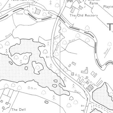
10 2 ARCHAEOLOGICAL AND HISTORICAL SOURCES 2.1 Historical Sources Place-name and Domesday Survey The name Taverham is likely to have been derived from teafor (Old English) to mean 'red lead, vermilon' (Smith 1987, 177). Smith suggested this name may be to do with red-painted buildings which may have been located here? Professor Ekwall in his dictionary of place-names has a similar definition 'red pigment or vermilon' plus ham meaning village or homestead (quoted in Norgate 1969, 12). Norgate himself suggested Taverham derived from Tawian (Tanner in Old English) and the ham ending suggested a settlement of some importance which dated from the Early Saxon period (5th-7th century (ibid, 12)). River Wensum itself derives from the meaning wandering (ibid, 12) Taverham was an important centre in both the Late Saxon and early medieval period and this can be seen by the fact that it was named as the head of one of Norfolk's 33 hundreds. The Domesday Survey (1086) records that Taverham was split between six landholders (King William, Count Allan, William of Warenne, Bishop William, lands of St Michael of Norwich and Ralph of Baufour)(Morris 1984). This survey notes that St Edmunds Church and presumably the main settlement was associated with the church, although there may have been other settlement areas within the parish. There was two mills mentioned in the 1086 with King William owning 1½ mills with William of Warenne and Ralph of Baufour each owning ¼ of a mill Costessey is derived from Kost's Island (Old English), and this name dates probably from the 7th century. Costessey was the centre of an important Middle Saxon estate which survived reasonably intact into the Late Saxon period (Williamson 1993, 96-8 and 133). It was in the Forehoe Hundred and in 1086 the Domesday Survey recorded that the parish was entirely owned by Count Allan, although he had some under-tenants (Morris 1984). In this parish the Domesday Survey also mentioned that there were two mills. Taverham Mill One of the two mills recorded in the Domesday book for Taverham was probably in/adjacent to the area of the proposed development. It was used as a corn mill, but later went on to grind bone meal and animal fodder ( The date of the establishment of it as a paper mill is uncertain, but the first documentary record for it is 1701 when this papermill came into the news by manufacturing high quality paper and helping to break a near monopoly held by the White Paper Makers Co. (Norgate 1969, 46). In a pamphlet by Francis Burgess dated 1701, Taverham Paper mill was recorded as being within four miles from Norwich and producing cheap paper for books with the paper sent to London (Ibid, 41) In 1807 it was fitted with Fourdrinier fourvat machines, among the first in Britain, but these seem not to have worked well. In the early 19th century there were two separate plants, one for brown paper and one for white ( It was attacked in the 1830 Captain Swing machine riots and the plant was damaged. From the mill complex was worked by 11 steam engines, three water wheels and c.150 workers in various buildings over a four acre area (Figs. 5 and 6). Rags were collected from the surrounding area and taken to the mill, lime came from pits in Costessey Lane. The finished paper was then taken by cart to Norwich railway station Oxford Archaeology East Page 9 of 24 Report Number 1469
11 ( At its peak in the late 19th century it produced around 25 tonnes of paper per day and this was used to make various books including the Oxford English Dictionary, bank notes for the Bank of England as well as several newspapers including The Times. The mill was having economic problems in the very late 19th century and was sold in 1890 but this did not work- its closure took place on 19th April 1899 and when this occurred it was the last of about a dozen paper mills (and by far the biggest) in Norfolk to close. USAAF B24 Liberator The record of the USAAF B24 Liberator which crashed partly within the site was kindly obtained by Mike Stowe (Appendix A). This report details how the plane broke up in poor conditions at 14,000 feet and the outcome with two crew surviving but also that eight died. 2.2 The Historic Environment Record (HER) The Norfolk HER was searched for archaeological sites, historic buildings and historic landscapes within a 0.5km study area centred on the development site (Fig. 2; Appendix B). There were no Scheduled Monuments, Registered Battlefields or Historic Parks and Gardens within the study area. There were 33 NHER records within this study area with a few of these being multi-period. Prehistoric six prehistoric NHER records (7830, 7832, 19753, 22989, and 40550) were recorded in the study area and all are located between 0.3km and 0.5km+ from the site. Two may relate to settlement or burial and these comprise a possible ring ditch with Beaker pottery close to it (NHER 7830; 0.5km to the north-west) and the other to Iron Age pottery and pot boilers recovered during field walking at least 0.5km to the west (NHER 40550). The other four records comprised single Neolithic or Bronze Age flint artefacts. Roman A single Roman record relates either to settlement or casual loss with pottery recovered during field walking at least 0.5km to the west (NHER 40550). Late Saxon and medieval The NHER do not any records of sites or artefacts dating to the Early or Middle Saxon periods. In contrast the Late Saxon and medieval are the most numerous with 14 separate records including one within the proposed development site and the other 13 all to the north of the River Wensum to the east, north and west of the site The HER notes that Taverham Mill (NHER 7902) may have been the location of one of the two watermills recorded for the parish in the Domesday Survey (1086). Medieval and later pottery as well as a human child's jaw bone has also been found within this area by members of the public. The HER states that the jaw bone was found before 1992 "on the north bank of the mill complex", which seems to suggest this was directly beyond the northern arm of the River Wensum an the town side? It is possible therefore that when this later northern arm of this river was dug to incorporate a mill, it could have disturbed earlier remains? The HER states that the 15th century langerware stoneware was found in 1998, but its exact location was uncertain. Oxford Archaeology East Page 10 of 24 Report Number 1469
12 2.2.6 The other HER records implies that there were two separate Late Saxon and medieval settlements within 0.5km of the development site. The main settlement is centred around the church of St. Edmund (NHER 7908) with its Saxon cross and a possible medieval guildhall (NHER 13257), 0.25km to the north-east of the site. Five Late Saxon/medieval find spots were located near to the church and comprised a Saxon whetstone and two Saxon or medieval pottery sherds (NHER 7842) and single metal objects (23866, 23987, and 24897), although the latter four had been given a general co-ordinate location of TG but the HER located them to the positions shown in Fig A second settlement is suggested 0.5km+ to the west of the proposed development site and comprises a sub-square 0.3km² area of cropmarks (NHER 54462), an adjacent possible moated manor site 0.4km away (NHER 25715) and find spots of Late Saxon and medieval pottery at NHER and medieval pottery and quern at NHER The second Taverham mill recorded in the Domesday Survey has probably been found as medieval documents suggest there was a mill at the site of Tunstall's Yard, c.200m to the south-east of the proposed development site (NHER 29022). A single possible medieval pottery sherd (NHER 7900) was found 0.5km to the north, but its significance is uncertain. Post-medieval and modern Within/adjacent to the proposed development area, there are three HER records. Partly on the development area, a paper mill dating from c.ad 1700 was recorded and it ceased use by 1900 (NHER 7902). The HER notes that the only standing remains of this mill is a brick lined mill race. Post medieval pottery has been found within the development area in the 1990s. In the area of one of the proposed pedestrian bridges, there had been a 19th century bridge (NHER 13217) linking Taverham Mill to Taverham Lane and it is shown on 1st Ordnance Survey edition " map A WWII USAAF B24 Liberator crashed on 21st April 1944 partly within and adjacent to the west of the development site (HER 55474) and in 2011 a memorial was unveiled in the development area (Plate 4). The plane broke up in the air and the HER records that the exact location of where the debris fell was not clear, but 'newspaper reports from when the memorial was unveiled suggest that it lies to the south of the River Wensum'. The HER has drawn an area (142m by 108m) where the remains of the plane may lie Directly to the north of the site, lies part of the former extensive post-medieval Taverham Park (NHER 30525). This park was created soon after 1784 and it extended over a c.1km by c.0.5km oval area, mostly to the west of the site. One undated postmedieval possible building lay within the north-eastern part of this park, 150m to the west of the site (NHER 7899), post-medieval earthworks (NHER 54462) and pottery (NHER 32781) have been found 0.4km and 0.5km+ to the west respectively In the area around St Edmunds Church, c.250m to the north-east several postmedieval and modern buildings and a road sign are recorded (NHERS 16689, 42787, 41916, and 57032). A WWII military camp lay 0.5km to the north of the site (NHER 54461). Oxford Archaeology East Page 11 of 24 Report Number 1469
13 Undated Three undated HER records in the study area comprise cropmarks of ditches of unknown date 0.5km+ to the south, and two find spots (NHERs 7911 and 7909), 0.3km to the north-west and south-west respectively. 2.3 Cartographic Evidence The proposed development straddles two parishes (Taverham and Costessey) and maps from both parishes were examined at the Norfolk Record Office (Figs. 2-6). Taverham maps 1740 and 1780s maps The earliest map for Taverham dates to AD 1740 and is the Church Commissioners map (no ). This map was copied in the 1780s with no changes to plot or buildings within the proposed development area and adjacent to it (NRO 276/1/1048). The later copy is included as Fig. 3 as it is clearer and includes some relevant written texts which the earlier original map does not. The two maps show that the River Wensum has been altered with the 1780s map including the text "The Old River" next to the southern branch of the River Wensum. The two maps suggest that the original river had been meandering, and presumably as part of the mill construction this northern branch of the River Wensum was either made by extending a previous minor tributary of the river or the wholesale straightening of the river through a formerly untouched stretch of land. It may be significant that the 1780s map has the southern branch of the river as "old", suggesting that this insertion of a new river route had been done relatively recently to the drawing of the map to incorporate the paper mill which was drawn crossing through this northern river branch on the western side. The maps show a road leading from the village centre and running up to mill but it does not cross over the river into the 'island' where part of the present development is proposed Tithe map The 1844 Tithe map (Fig. 4; NRO 844) shows some changes next to the development area had occurred since the 1740 and 1780s maps. The main mill building across the northern branch remained, but a new leat runs north-west to south-east parallel to the north of the River Wensum up to the mill's northern side. A bridge now crosses over the northern branch of the river, adjacent to the east of the main mill building, into the proposed development area. This road presumably leads to the new small building which straddles the southern 'original' arm of the River Wensum possibly just within the site. In the 'island' itself the map has 157 recorded on it and this is listed as mill meadow, suggesting that the area of the proposed development was left largely untouched. Costessey mid 19th century maps The proposed development site lies well away from the settlement in this parish in former meadow areas (i.e. marginal agricultural land) and therefore maps for this part of Costessey are few The 1839 Tithe map of Costessey (Fig. 7; NRO DH/TA 555) records the development area to the south of Taverham parish for the first time. The site is on the edge of the map where it is very worn. The proposed development area is within land marked 275 ('Thorufare Meadow') and 273 ('Mill Meadow'). In the latter area, the southern mill building across the River Wensum is shown as well as an adjacent building to the south Oxford Archaeology East Page 12 of 24 Report Number 1469
14 of it, presumably a related building. These two buildings are located at/just beyond the extreme western limits of proposed development area. To the east and south-east of the site are plots 40 and 41 (both 'Common Meadows') The 1857 Enclosure map (NRO C/SCA/78; not illustrated) has the area as one land ownership (128). Costessey and Taverham late 19th and 20th century maps 1st Edition Ordnance Survey Map (1890) and Taverham Paper Mills map The st Edition Ordnance Survey Map (Fig. 5) has many new mill related buildings showing the site had significantly expanded since the 1844 Tithe map. The mill buildings shown on this 1st OS are drawn in a larger scale on the?contemporary Taverham Paper Mill map (Fig. 6; NRO BR 276/1/0357). Fourteen mill buildings are recorded on the maps, with the majority located directly to the north of the River Wensum but with the 'island there are several buildings on the western side including two just running into the proposed development area. No buildings are shown on the eastern part of the island within the area of the proposed visitor centre or the footbridge. Instead within this area there is a new road and bridge to the east which, for the first time, linked the Taverham Paper Mill complex to Taverham Lane and thereby allowing a new access to this expanded mill complex There were several late 19th century maps in the NRO record office relating to various aspects of the above expanded Victorian Paper mill complex with more detailed aspects of the above buildings. There was another overall map of the mill buildings, but the NRO record records it was in a fragile condition fragile and therefore it has not been used The 1st Edition 1890 Ordnance Survey map has the Costessey parish area comprising a single field with streams including one within the western side of the site, presumably either dug for this expanded mill complex and/or allowing better drainage in this low lying area (Fig. 5). 2nd Edition Ordnance Survey Map (1907) This 2nd edition OS map shows the mill buildings within Taverham parish still remaining (not illustrated). The bridge crossing the southern arm of the River Wensum to Taverham Lane has been removed. Trees are recorded growing within the centre and southern part of the 'island'. The Costessey parish part of the development area has not changed compared with the 1st Edition map. 3rd Edition Ordnance Survey Map (1938) The 3rd edition OS map (not illustrated) shows the same details as the 1907 map. Ordnance Survey Map(1957) The mill buildings have gone by the 1957 map with the possible exception of the small brick building in the northern part of the 'island' (not illustrated). The Costessey area has still not changed except large scale quarrying had taken place directly to the south of the proposed development area. Ordnance Survey map (1964) The1964 map shows changes within the 'island area' (not illustrated). The brick building still stands but three prefabricated structures had been built within the centre of the 'island'. The Costessey area had not changed from the previous map. Oxford Archaeology East Page 13 of 24 Report Number 1469
15 2.4 Aerial Photographs The Norfolk HER aerial photographs section was examined during the HER visit. The proposed development area is in area which has been meadow land and the underlying natural is peat. No cropmarks was visible within the site. Aerial photograph TG11- TG1513-A-16APR1946-RAF.jpg (Plate 1) shows extraction of Brown Sands had taken place directly to the south of the proposed car park (in an area where a new woodland has since been planted). 2.5 Earthworks No earthworks could be seen within the proposed development area during the site visit. 2.6 Archaeological Excavations and Surveys There has been no excavations or evaluations within the proposed development area and extremely limited archaeological work has taken place within the 0.5km study area around (see Section 2.2 above). Oxford Archaeology East Page 14 of 24 Report Number 1469
16 3 DEPOSIT MAPPING 3.1 General This section aims to broadly predict the existence of archaeological remains within the development area based on the mapping of the distribution of all known historic assets outlined in the previous sections. The lack of archaeological work within the study area does mean that deposit mapping has to be taken with caution. 3.2 Prehistoric There is no evidence of prehistoric evidence within 0.3km of the site and only six prehistoric records have been recorded within the study area with the majority comprising single find spots The area of the proposed development is adjacent and up to c.150m from a significant river, and this location would have been favoured in prehistoric times. Activity from Mesolithic and Early Neolithic people were often next to river sides and later prehistoric people (Mid/Late Neolithic to Iron Age) often gravitating slightly further away on slightly higher ground. At Thetford for example, where unlike Taverham there has been significant quantity of archaeological work, several flint working areas and burnt mounds have been recorded/excavated in recent years over a c.5km distance adjacent or close to the River Thet (Atkins and Connor 2010, 107; fig. 2). The majority of these features were single isolated examples, although in one of the Thetford sites there was significant flint working evidence The proposed development includes two bridges over the old former meandering southern branch of the river. The underlying geology is peat, which is significant as pollen is known to survive well in waterlogged peat deposits The proposed development area is relatively small and overall there is a low probability of encountering prehistoric artefacts/features, but considering the location of this site at a major river, this can not be ruled out. There is extremely high chance that former river channel deposits and any environmental remains in them survive. Analysis of these deposits may produce an understanding of the environment and possibly even agricultural practices in the neighbourhood of the development area over time. 3.3 Roman A single Roman find spot has been recorded in the study area, c.0.5km away. Roman settlements were often located near to rivers, on slightly higher ground. The finding of a child's jaw bone seemingly directly to the north of the site, on the northern bank of the mill complex, raises interesting questions. The presumed burial is unlikely to be Mid Saxon or later as people in this period were Christian and would have been buried in St Edmunds Church, 0.25km away. Was the jaw bone a disturbed burial when this northern arm of the River Wensum dug to locate the mill on the straightened river? If it was from a burial, it is therefore likely to be any date before the Mid Saxon period with perhaps a Roman date most likely as Roman burials were often interred next to rivers? There is low probability of encountering Roman remains within the development site, however, as there has been no archaeological investigations within proximity, this cannot be entirely ruled out and the finding of a human jaw bone in the vicinity raises possibilities? Oxford Archaeology East Page 15 of 24 Report Number 1469
17 3.4 Saxon and medieval In the study area, the HER has numerous records for Late Saxon and medieval Taverham, although none for Costessey parish. The records suggest that general area in/around the development area there had been a watermill, one of two recorded in the Domesday Survey for Taverham. It is more likely the mill had been located on the old river route (southern branch of the River Wensum) and not the northern branch of the river, which may have been deliberately constructed for a powermill in c.ad 1700 (see Section above). If is therefore entirely possible that the medieval watermill was within the proposed development area? There were two Late Saxon and medieval settlements recorded within the study area. it is possible that part of the eastern settlement located around St Edmunds church continued up to or into the site. The present bridge located directly to the east of the site, c.up to 50m away from the development area, was presumably on the site of a former medieval bridge. It is possible, even likely that houses had originally fronted Costessey Road on the northern bank of the river, up to and beyond the church? Whether back plots of any settlement continued into the development area is uncertain and it is possibly depended on when/if the northern branch of the River Wensum had been constructed in the medieval or post-medieval period. If it was the former, it is unlikely any medieval structure was within the 'island'. It is extremely unlikely that western Late Saxon and medieval settlement with its moated manor and earthworks 0.3km -0.5km+ away, continued into the development area The main (and possibly the only) Late Saxon and medieval settlement in Costessey parish lies more than 1km to the east. The mid 19th century maps record the proposed development area in Costessey parish being meadowland with no evidence of settlement in the vicinity There is low to moderate probability of medieval remains within the northern part of the development area in Taverham parish, but extremely low for the southern side in Costessey parish. 3.5 Post-medieval and modern The post-medieval paper mill was located to the north-west of the development site, but significantly the map evidence from AD 1740 and 1780 informs us the islands was unused in this period with no structures or even a bridge crossed into this area. The 1844 Taverham tithe map shows that the site was within meadow land and although a bridge had been built over the northern branch of the river this was linked to a new building crossing the southern branch of the river, just within/adjacent to the proposed development area. This latter building is also recorded on the 1839 Costessey tithe map with a further probably related building adjacent to the south of it. Part of the mid/late 19th century mill complex in Taverham parish runs into the western part of the development area, but not as far as the proposed location of the proposed visitor centre. A mid or late 19th century road and a bridge was within the development area with the visitor centre where the former road had been It is likely that the crash site of the B24 liberator was within and to the south-west of the development area, with the plane falling over an area directly to the south of the river (eye witnesses remembering the event in 2011). The plane broke up at 14,000 ft and so it is uncertain how wide its remains lie There is low possibility of finding post AD 1700 to early 19th century remains within the site but high possibility of c. mid 19th and later remains within it. Oxford Archaeology East Page 16 of 24 Report Number 1469
18 4 DEGREE OF SURVIVAL 4.1 General This section broadly assesses the degree of likely survival of any archaeological remains in the site. It has not been possible to provide a detailed predictive deposit model as there has been (on present knowledge) no site investigation reports and there are no definite recorded finds from the site, therefore the following is intended as a guide only The northern area of the proposed development within Taverham parish is more difficult to gauge as it may have been affected by a mid/late 19th century road and bridge constructed within the site. It is uncertain how deep the road was constructed. The mid 20th century prefab huts and car park may also have affected any archaeological remains within the area. The southern part within Costessey parish has been affected only by possible ploughing in recent times, although mostly it has been used as meadow land. Oxford Archaeology East Page 17 of 24 Report Number 1469
19 5 CONCLUSIONS 5.1 General The object of this desk-based assessment was to assess the archaeological potential of the development site by drawing together all known documentary, cartographic and archaeological evidence from the surrounding area There is low potential for prehistoric archaeological features with the development area, but considerable likelihood of pollen remains surviving from within any former river channel deposits and analysis of these have the potential for understanding the environmental landscape around the site over time. It is uncertain the significance or even the age of the child's jaw bone found directly to the north of the site The medieval potential for archaeological remains is also unknown. It is uncertain where a mill recorded in the Domesday Survey was exactly located, and even whether the main Late Saxon/early medieval settlement of Taverham continued into the site. Of relevance is when the northern arm of the River Wensum to form the present island was dug, it seems more likely to have occurred when a new paper mill was built in c.ad1700. If this was the case, the medieval mill would have been built across the southern original branch of the river, possibly within the development area. If the river had been straightened on this northern side in the Late Saxon period, the original mill would have been located across this stretch and therefore away from the proposed development The important post-medieval paper mill did not initially affect the proposed development area seemingly lying to the north-west of it and it was only in the c. mid 19th century was the site definitely built on with parts of two buildings, a road and bridge constructed to link the expanding mill complex with Taverham Lane, and a probable c.mid 19th century mill building within Costessey parish In the modern era, it is likely that part of the remains of a B24 Liberator lies buried within the development area, as eye witnesses stipulate that it crashed in this general location. Oxford Archaeology East Page 18 of 24 Report Number 1469
20 APPENDIX A. USAAF B24 LIBERATOR CRASH REPORT Oxford Archaeology East Page 19 of 24 Report Number 1469
21

22
23
24 APPENDIX B. HER RECORDS WITHIN 0.5KM OF PROPOSED DEVELOPMENT NHER No. Name Comments NGR (TG) 7830?Monument A?ring ditch shown as possible cropmark on a 1946 aerial photo. In 1958 Beaker pottery was found in park near to the cropmark location. Small scale excavations in location adjacent to the Neolithic pottery found only early medieval and post-med pottery Find spot Neolithic axe found in Find spot Medieval pottery and quern; p-med knife were found in Find spot Saxon whetstone and two sherds of Saxon or med pottery were found in ?Monument Possible post-medieval building foundations were exposed while ploughing in Find spot A single?medieval 12th century pottery sherd was recovered Monument Taverham Mill has possible?domesday origins. A post-medieval paper mill on site dates from c.1700 and this was 'one of the most important in the country'. Mill abandoned c.1900 and only Mill Race remains as 'standing' feature. Medieval and post-medieval pottery sherds and a child's jaw bone were found in area of mill in the 1990s 7908 Monument St Edmund's Church has Saxo-Norman origins and inside the church there is a Late Saxon cross Find spot Undated nail Find spot Undated lava millstone was found in Monument Post-medieval bridge shown on 1st Ordnance Survey edition " map linking Taverham Mill and Taverham Lane - bridge no longer exists Monument Records show there may have been a medieval Guildhall at Taverham. A 17th century terrier seems to support this, but if there had been a guildhall it no longer exists as upstanding remains Monument Modern 1930s lime kiln has since been buried Find spot Neolithic flint axe was found in Find spot Prehistoric flint blade was found in Find spot Late Saxon disc brooch was uncovered by metal detector in Find spot Late Saxon strap end was uncovered by metal detector in Find spot Late Saxon disc brooch was uncovered by metal detector in Find spot Late Saxon/early medieval copper-alloy object was uncovered by metal detector in Monument Site of possible medieval moated manor in Taverham Park comprises rectangle of ditches by river 60m by 30m and these were up to 4m wide - survives as shallow depressions in ground Monument According to medieval documents Tunstalls Yard was the site of a medieval watermill Monument Taverham Park was created soon after 1784 and incorporated existing woodland. Some trees were planted 1840 and a formal garden was laid in A small portion of park survives including a late 19th century kitchen Find spot Iron Age, Roman Late Saxon, medieval and post-medieval pottery were found during fieldwalking over a large area in Other finds include possible prehistoric pot boilers Find spot Neolithic/Bronze Age arrowhead was found in Oxford Archaeology East Page 20 of 24 Report Number 1469
25 41787 Monument Undated brick building foundations were seen in 2005 whilst digging holes for fence posts Monument Late 18th/early 19th century remains of Church Farm barn Monument WWII air raid shelter (Anderson) in Taverham - this is one of a number of shelters including in central Norwich and confusingly all given one number and one grid reference Monument WWII military camp in Taverham Park Monument Medieval to post-medieval earthworks within Taverham Park - and these were part of a possible former settlement and related field system. Earthworks comprised hollow ways, boundary ditches and banks Monument Cropmarks of ditches of unknown date Monument Taverham School built in Monument Site of USAAF B24 Liberator air crash on 21st April There is a memorial erected in 2011to the crew Monument 1921 road place name sign Table 1: NHER records for find spots and monuments within 0.5km of proposed development Oxford Archaeology East Page 21 of 24 Report Number 1469
26 APPENDIX C. BIBLIOGRAPHY Atkins, R. and Connor, A., 2010 Farmers and ironsmits: prehistoric, Roman and Anglo-Saxon settlement beside Brandon Road, Thetford, Norfolk E. Anglian Archaeol. 134 (Oxford Archaeology East: Bar Hill) Morris, S. (ed.)., 1984 Norfolk (Phillimore: Titus Wilson (Kendal)) Norgate, T. B., 1969 A history of Taverham from early times to 1969 (FC Barnwell, Aylsham) Savills 2012 Pre application consultation document for proposed new visitor centre and car park dated November 2012 (unpublished) Smith, A.H., 1987 English Place-Name elements: English Place-Name Society vol XXVI Part II (Cambridge University Press) Williamson, T., 1993 The origins of Norfolk (Manchester University Press) Websites consulted accessed May 5th 2013 Cartographic sources Taverham Church Commissioners map (no ) AD 1740 (surveyed by I Say) Taverham c.1780s map (NRO 276/1/1048) Taverham 1844 Tithe map (NRO 844) Taverham Paper Mills map (NRO BR 276/1/0357) Costessey Tithe map 1839 (NRO DH/TA 555) Costessey Enclosure map 1857 (NRO C/SCA/78) First Edition Ordnance Survey Map (1890) Second Edition Ordnance Survey Map (1907) Third Edition Ordnance Survey Map (1938) 1957 Edition Ordnance Survey map 1964 Edition Ordnance Survey map Oxford Archaeology East Page 22 of 24 Report Number 1469
27 APPENDIX D. OASIS REPORT FORM All fields are required unless they are not applicable. Project Details OASIS Number Project Name Project Dates (fieldwork) Start Finish Previous Work (by OA East) oxfordar Desk-Based Assessment at Taverham Mill Nature Reserve No Future Work Unknown Project Reference Codes Site Code XNFTAV13 Planning App. No. N/A HER No. N/A Related HER/OASIS No. N/A Type of Project/Techniques Used Prompt Voluntary/self-interest Development Type Amenity Area (e.g. public open space) Please select all techniques used: DBA Aerial Photography - interpretation Aerial Photography - new Documentary Search Visual Inspection (Site Visit) Monument Types & Period List feature types using the NMR Monument Type Thesaurus together with their respective periods. If no features were found, please state none. Monument Period N/A Select period... N/A Select period... N/A Select period... N/A Project Location Select period... County District Parish HER Norfolk Broadlands + South Norfol Taverham + Costessey Norfolk Site Address (including postcode if possible) Taverham Mill Fisheries Costessey Rd Taverham, Norwich NR8 6TA Study Area National Grid Reference 0.5 sq km TG Oxford Archaeology East Page 23 of 24 Report Number 1469
28 Project Originators Organisation Project Brief Originator Project Design Originator Project Manager Supervisor OA EAST N/A N/A Dr Paul Spoerry Rob Atkins Project Archives Physical Archive Digital Archive Paper Archive OA East OA East OA East XNFTAV13 XNFTAV13 XNFTAV13 Archive Contents/Media Physical Contents Digital Contents Paper Contents Digital Media Paper Media Animal Bones Ceramics Environmental Glass Human Bones Industrial Leather Metal Stratigraphic Survey Textiles Wood Worked Bone Worked Stone/Lithic None Other Database GIS Geophysics Images Illustrations Moving Image Spreadsheets Survey Text Virtual Reality Aerial Photos Context Sheet Correspondence Diary Drawing Manuscript Map Matrices Microfilm Misc. Research/Notes Photos Plans Report Sections Survey Notes: Oxford Archaeology East Page 24 of 24 Report Number 1469


29 0 5km N Visitor Centre Footbridges Car Park


30 Figure 2: HER records within 0.5km of development area m Scale 1:13,250 N Oxford Archaeology East Report Number 1469 Crown copyright and database rights 2011 Ordnance nce Survey
 with proposed development area")
31 Figure 3: c map of Taverham (NRO 276/1/1048) with proposed development area outlined red Oxford Archaeology East Report Number 1469

32 Figure 4: 1844 Tithe map of Taverham (NRO 844) with proposed development area outlined red Oxford Archaeology East Report Number 1469

33 Oxford Archaeology East Report Number 1469 Figure 5: 1st Edition Ordnance Survey Map with proposed development area outlined red

34 Oxford Archaeology East Report Number 1469 Figure 6: Taverham paper mills (NRO 276/1/0357) N
 with proposed development area outlined")
35 Oxford Archaeology East Report Number 1469 Figure 7: 1839 Tithe map of Costessey (NRO DH/TA 555) with proposed development area outlined red

 Oxford")
36 Plate 1: Aerial photograph TG11-TG1513-A-16APR1946-RAF ( Norfolk County Council) Plate 2: Area of proposed new visitor centre (looking west) Oxford Archaeology East Report Number 1469
 Plate 4:")

37 Plate 3: Location of proposed footbridge over the River Wensum with area of car park in distance (looking south) Plate 4: Memorial to the crewmen of USAAF B24 Liberator B24J which crashed 21st April 1944 Oxford Archaeology East Report Number 1469
38 Head Office/Registered Office/ OA South Janus House Osney Mead Oxford OX2 0ES t: +44 ( 0) f: +44 (0) e: info@oxfordarchaeology.com w: OA North Mill 3 Moor Lane Lancaster LA1 1GF t: +44 ( 0) f: +44 ( 0) e: oanorth@oxfordarchaeology.com w: OA East 15 Trafalgar Way Bar Hill Cambridgeshire CB23 8SQ t: +44 (0) e: oaeast@oxfordarchaeology.com w: Director: Gill Hey, BA PhD FSA MIFA Oxford Archaeology Ltd is a Private Limited Company, N o : and a Registered Charity, N o :
Neale Wade Community. College, March Cambridgeshire. Desktop Assessment. Client: Cambridgeshire County Council. March 2009
 Neale Wade Community Desktop Assessment Desktop Assessment College, March Cambridgeshire March 2009 Client: Cambridgeshire County Council OA East Report No: 1095 OASIS No: Oxfordar3-56453 NGR: TL 417 952
Following the initial soil strip archaeology is sprayed up prior to planning and excavation
 Barton Quarry & Archaeology Over the past half century quarries have been increasingly highlighted as important sources of information for geologists, palaeontologists and archaeologists, both through
Kelling Heath Holiday Park, Weybourne, Norfolk
 Earthwork Survey and Desk-Based Assessment October 2013 Client: Bidwells/ Blue Sky Leisure OA East Report No: 1537 OASIS No: oxfordar3-161216 NGR: TG 1171 4140 Desk-Based Assessment Kelling Heath Holiday
Land off Birdie Way, Rush Green, Hertford, Hertfordshire
 Land off Birdie Way, Rush Green, Hertford, Hertfordshire An Archaeological Evaluation for Bride Hall Development Limited by Sarah Coles Thames Valley Archaeological Services Site Code RGH00/ 01 January
o a London Borough of Barnet Stoney Wood Lake Silk Stream Flood Alleviation Scheme Archaeological Watching Brief Report Oxford Archaeology
 Silk Stream Flood Alleviation Scheme Stoney Wood Lake London Borough of Barnet Archaeological Watching Brief Report o a Oxford Archaeology November 2004 Client: Halcrow on behalf of Environment Agency
Archaeological Monitoring at Ham Farm, Ham Road, Faversham, Kent
 Archaeological Monitoring at Ham Farm, Ham Road, Faversham, Kent NGR: 601750.0mE 162695.0mN Site Code HAM/WB/12 Report for A.J. Bray SWAT ARCHAEOLOGY Swale and Thames Archaeological Survey Company The
Archaeological Investigations Project South East Region SOUTHAMPTON 2/842 (C.80.C004) SU
 SU") SOUTHAMPTON City of Southampton 2/842 (C.80.C004) SU 4382 1336 125 BITTERNE ROAD WEST, SOUTHAMPTON Report on the Archaeological Evaluation Excavation at 125 Bitterne Road West, Southampton Russel, A. D
SOUTHAMPTON City of Southampton 2/842 (C.80.C004) SU 4382 1336 125 BITTERNE ROAD WEST, SOUTHAMPTON Report on the Archaeological Evaluation Excavation at 125 Bitterne Road West, Southampton Russel, A. D
Wheatlands House, Fleet Hill, Finchampstead, Berkshire
 Wheatlands House, Fleet Hill, Finchampstead, Berkshire An Archaeological Watching Brief For JCA International by James McNicoll-Norbury Thames Valley Archaeological Services Ltd Site Code WFF 08/26 August
Northamptonshire Archaeology
 Northamptonshire Archaeology A programme of archaeological observation, investigation and recording at St Andrews Church, Spratton, Northamptonshire Northamptonshire Archaeology 2 Bolton House Wootton
Archaeological Evaluation Report
 Holywell House Osney Mead Oxford o a November 2007 Client: Knowles and Son Issue N o : 1 OA Job N o : 3826 Planning Ref N o : 02/01800/FUL NGR: SP 502 055 Client Name: Knowles and Son Client Ref No: Document
Cholesbury New House, Parrots Lane, Cholesbury, Buckinghamshire
 Cholesbury New House, Parrots Lane, Cholesbury, Buckinghamshire An Archaeological Watching Brief For Mr Martin Wood by Sean Wallis Thames Valley Archaeological Services Ltd Site Code PLC 06/135 March 2007
4. Bronze Age Ballybrowney, County Cork Eamonn Cotter
 4. Bronze Age Ballybrowney, County Cork Eamonn Cotter Illus. 1 Location map of the excavated features at Ballybrowney Lower (Archaeological Consultancy Services Ltd, based on the Ordnance Survey Ireland
Archaeological Watching Brief at the Brick Stables and Wagon Lodge, Abbey Barns, Abbey Road, Faversham, Kent September 2010
 Archaeological Watching Brief at the Brick Stables and Wagon Lodge, Abbey Barns, Abbey Road, Faversham, Kent September 2010 SWAT. Archaeology Swale and Thames Archaeological Survey Company School Farm
Holyport Manor Special School, Highfield Lane, Cox Green, Maidenhead, Berkshire
 Holyport Manor Special School, Highfield Lane, Cox Green, Maidenhead, Berkshire An Archaeological recording action For CgMs Consulting by Jennifer Lowe Thames Valley Archaeological Services Ltd Site Code
BRONZE AGE FIELD SYSTEM AT SOUTHAMPTON AIRPORT
 Proc. Hampshire Field Club Archaeol. Soc. 65, 2010, 1-6 (Hampshire Studies 2010) BRONZE AGE FIELD SYSTEM AT SOUTHAMPTON AIRPORT By J SULIKOWSKA With contributions by LORRAINE MEPHAM and CHRIS J STEVENS
Aylesbury Masonic Hall, Ripon Street, Aylesbury, Buckinghamshire
 Aylesbury Masonic Hall, Ripon Street, Aylesbury, Buckinghamshire An Archaeological Recording Action for Wakefield Building Services by Andrew Mundin Thames Valley Archaeological Services Ltd Site Code
Sewer replacement works, Jesus Lane, Cambridge
 Sewer replacement works, Jesus Lane, Cambridge Archaeological Watching Brief Report March 2013 Client: Anglian Water Services OA East Report No: 1444 OASIS No: oxfordar3-144548 NGR: TL 4510 5882 Archaeological
Archaeological Watching Brief on land at Alpha, Gore Road, Eastry, Kent July 2010
 Archaeological Watching Brief on land at Alpha, Gore Road, Eastry, Kent July 2010 SWAT. Archaeology Swale and Thames Archaeological Survey Company School Farm Oast, Graveney Road Faversham, Kent ME13 8UP
HILL-FORTS OF THE INNER TAY ESTUARY PERTH. Phase One PERTH AND KINROSS. Archaeological Survey Report. Oxford Archaeology North.
 HILL-FORTS OF THE INNER TAY ESTUARY PERTH PERTH AND KINROSS Phase One Archaeological Survey Report Oxford Archaeology North September 2012 Issue No: 2012-13/11322 OAN Job No: L10492a NGR: NO 182 153, NO
Desk-Based Assessment
 Land off Cox's Drove Fulbourn Desk-Based Assessment August 2013 Client: Savills OA East Report No: 1510 OASIS No: oxfordar3-156741 NGR: TL 51694 56593 Desk-Based Assessment Land off Cox's Drove, Fulbourn
The Coach House, Mill Lane, Cookham, Berkshire
 The Coach House, Mill Lane, Cookham, Berkshire An Archaeological Watching Brief For Ms Sophia Butler by Stephen Hammond Thames Valley Archaeological Services Ltd Site Code CMC 03/104 October 2003 Summary
ARCHAEOLOGICAL S E R V I C E S. Phase 5, Grimsby Road, Cippenham, Slough, Berkshire. Archaeological Recording Action.
 T H A M E S V A L L E Y ARCHAEOLOGICAL S E R V I C E S Phase 5, Grimsby Road, Cippenham, Slough, Berkshire Archaeological Recording Action by Andy Taylor Site Code: GRC13/57 (SU 9493 7977) Phase 5, Eltham
South East Region SOUTHAMPTON 3/1050 (E.80.H006) SU
 SU") SOUTHAMPTON 3/1050 (E.80.H006) SU 43351328 16 HAWKESWOOD ROAD Report on the Archaeological Observations at 16 Hawkeswood Road, Bitterne Manor Russil, A & Smith, M Southampton : Southampton City Council
SOUTHAMPTON 3/1050 (E.80.H006) SU 43351328 16 HAWKESWOOD ROAD Report on the Archaeological Observations at 16 Hawkeswood Road, Bitterne Manor Russil, A & Smith, M Southampton : Southampton City Council
Addington Village Farm, Addington Village Road, London Borough of Croydon
 Addington Village Farm, Addington Village Road, London Borough of Croydon An Archaeological Desk-Based Assessment for Bewley Homes PLC by Steve Ford Thames Valley Archaeological Services Site Code ARC00/47
An archaeological excavation at 193 High Street, Kelvedon, Essex September 2009
 An archaeological excavation at 193 High Street, Kelvedon, Essex September 2009 report prepared by Ben Holloway and Howard Brooks on behalf of Marden Homes CAT project ref.: 09/4g NGR: TL 8631 1913 (c)
FOUNDATIONS OF ARCHAEOLOGY A WALK IN VERNDITCH CHASE
 FOUNDATIONS OF ARCHAEOLOGY A WALK IN VERNDITCH CHASE 1. A Tale of two Long Barrows Long barrows were constructed as earthen or drystone mounds with flanking ditches and acted as funerary monuments during
The Archaeology of Cheltenham
 The Archaeology of Cheltenham The archaeology collection of The Wilson contains a rich quantity of material relating to the prehistoric and Roman occupation of the North Cotswolds and parts of the Severn
Wessex Archaeology. Little Stubbings, West Amesbury, Salisbury, Wiltshire. Archaeological Watching Brief. Ref:
 Wessex Archaeology Little Stubbings, West Amesbury, Salisbury, Wiltshire Ref: 63280.02 March 2007 LITTLE STUBBINGS, WEST AMESBURY, NR SALISBURY, WILTSHIRE ARCHAEOLOGICAL WATCHING BRIEF Prepared for: P
An archaeological watching brief on land adjacent to 50 Rosebery Avenue, Colchester, Essex May/June 2003
 An archaeological watching brief on land adjacent to 50 Rosebery Avenue, Colchester, Essex May/June 2003 report prepared by C Crossan on behalf of Highfield Homes Ltd NGR: TM 0035 2500 CAT project ref.:
ARDESTIE EARTH HOUSE HISTORIC ENVIRONMENT SCOTLAND STATEMENT OF SIGNIFICANCE. Property in Care no: 24
 Property in Care no: 24 Designations: Scheduled Monument (SM90021) Taken into State care: 1953 (Guardianship) Last reviewed: 2004 HISTORIC ENVIRONMENT SCOTLAND STATEMENT OF SIGNIFICANCE ARDESTIE EARTH
Gorse Stacks, Bus Interchange Excavations Interim Note-01
 Gorse Stacks, Bus Interchange Excavations 2015 Prepared for: Cheshire West & Chester Council Interim Note-01 1 Introduction & Summary Background Since c. 2000 investigations associated with redevelopment
Henderson Mess, RAF Halton, Buckinghamshire
 Henderson Mess, RAF Halton, Buckinghamshire An archaeological watching brief for Stepnell Ltd by Stephen Hammond Thames Valley Archaeological Services Ltd Site Code RHA03/85 October 2003 Summary Site name:
89 95 Ladbroke Road, Redhill, Surrey
 89 95 Ladbroke Road, Redhill, Surrey An Archaeological Desk-Based Assessment for Bovis Homes by Jennifer Lowe Thames Valley Archaeological Services Ltd Site Code LRR 03/36 April 2003 Summary Site name:
CARLUNGIE EARTH HOUSE
 Property in Care (PIC) ID: PIC015 Designations: Scheduled Monument (SM90059) Taken into State care: 1953 (Guardianship) Last reviewed: 2004 HISTORIC ENVIRONMENT SCOTLAND STATEMENT OF SIGNIFICANCE CARLUNGIE
S E R V I C E S. Land to the rear of Ashdown, Basingstoke Road, Spencers Wood, Reading, Berkshire. Archaeological Evaluation.
 T H A M E S V A L L E Y ARCHAEOLOGICAL S E R V I C E S Land to the rear of Ashdown, Basingstoke Road, Spencers Wood, Reading, Berkshire Archaeological Evaluation by Susan Porter Site Code: ASW12/21 (SU
The Old Shire Horse Centre, Bath Road, Woolley Green, Maidenhead, Berkshire
 The Old Shire Horse Centre, Bath Road, Woolley Green, Maidenhead, Berkshire An Archaeological Watching Brief For Mr Derek Chesterman by Andrew Mundin Thames Valley Archaeological Services Ltd Site Code
South West Region GLOUCESTERSHIRE 1/405 (B.23.H005) SU
 SU") GLOUCESTERSHIRE Cotswold 1/405 (B.23.H005) SU 16559880 COTSWOLD EASTERN SPINE ROAD STAGE 4 Cotswold Eastern Spine Road Stage 4 and Horcott Road. Watkins, K Gloucester : Gloucestershire County Council Archaeology
GLOUCESTERSHIRE Cotswold 1/405 (B.23.H005) SU 16559880 COTSWOLD EASTERN SPINE ROAD STAGE 4 Cotswold Eastern Spine Road Stage 4 and Horcott Road. Watkins, K Gloucester : Gloucestershire County Council Archaeology
Desk Based Assessment
 DRAFT Land to the south-east of St Mary's Church Brampton Huntingdonshire Desk Based Assessment February 2010 Client: Savills OA East Report No: 1161 OASIS No: Oxfordar3-72032 NGR: TL 2150 7060 Desk Based
Long Cairn Divis County Antrim
 Survey Report No. 66 Harry Welsh Long Cairn Divis County Antrim 2 Ulster Archaeological Society 2018 Ulster Archaeological Society c/o School of Natural and Built Environment Queen s University Belfast
Excavations in a Medieval Market Town: Mountsorrel, Leicestershire,
 Excavations in a Medieval Market Town: Mountsorrel, Leicestershire, by John Lucas Mountsorrel is situated 12 kms north of Leicester and forms a linear settlement straddling the A6, Leicester to Derby road.
Archaeological Investigations Project Yorkshire & Humberside Region NORTH YORKSHIRE 2/1113 (C.36.J002) SD
 SD") NORTH YORKSHIRE Craven 2/1113 (C.36.J002) SD 93607800 CRAY BECK, BUCKDEN, UPPER WHARFEDALE Cray Beck, The Archaeological Investigation of a Stone Feature Archetype Wensleydale : ArcheType Archaeological
NORTH YORKSHIRE Craven 2/1113 (C.36.J002) SD 93607800 CRAY BECK, BUCKDEN, UPPER WHARFEDALE Cray Beck, The Archaeological Investigation of a Stone Feature Archetype Wensleydale : ArcheType Archaeological
Revision: Date: Prepared by: Checked by: Approved by: Reason for Issue: Nick Elsden (MOLA) Nick Elsden (MOLA) Page 2
 Nick Elsden (MOLA) Page 2") This document contains proprietary information. No part of this document may be reproduced without prior written consent from the chief executive of Crossrail Ltd. Revision: Date: Prepared by: Checked
This document contains proprietary information. No part of this document may be reproduced without prior written consent from the chief executive of Crossrail Ltd. Revision: Date: Prepared by: Checked
Archaeological Investigations Project Eastern Region. Essex 2/197 (C.22.F025) TL
 TL") Essex Braintree 2/197 (C.22.F025) TL 75502284 BLANDFORD HOUSE, 7 LONDON ROAD, BRAINTREE Blandford House, 7 London Road, Braintree, Essex Davis, E Chelmsford : Essex County Council Field Archaeology Unit,
Essex Braintree 2/197 (C.22.F025) TL 75502284 BLANDFORD HOUSE, 7 LONDON ROAD, BRAINTREE Blandford House, 7 London Road, Braintree, Essex Davis, E Chelmsford : Essex County Council Field Archaeology Unit,
ROUKEN GLEN: BANDSTAND 2015 DATA STRUCTURE REPORT
 ROUKEN GLEN: BANDSTAND 2015 DATA STRUCTURE REPORT Author (s) Ian Hill Editors Report Date June 2015 Working Partners Funders Phil Richardson East Renfrewshire Council East Renfrewshire Council, Heritage
Pottery from Test-pits at Histon and Impington 14/15 May 2016
 Pottery from Test-pits at Histon and Impington 14/15 May 2016 Paul Blinkhorn The following pottery types were noted: BB: Brill/Boarstall Ware, c. AD1200-1600 (Mellor 1994). BD: Bourne D Ware, c. 1450-1637
An archaeological excavation and watching brief at the Musket Club, Homefield Road, Colchester, Essex December 2004-February 2005
 An archaeological excavation and watching brief at the Musket Club, Homefield Road, Colchester, Essex December 2004-February 2005 report prepared by Howard Brooks on behalf of RMPA and the MoD CAT project
ULSTER ARCHAEOLOGICAL SOCIETY
 ULSTER ARCHAEOLOGICAL SOCIETY Survey Report: No. 52 Survey and surface artefact collection at Ballytaylor, County Antrim UAS/14/01 In association with HENRY WELSH, KARA WARD AND MOIRA O ROURKE 2 Ulster
Monitoring Report No. 227
 City of Derry Airport Longfield More townland Eglinton County Derry AE/10/61 Ruth Logue Site Specific Information Site location: City of Derry Airport, Airport Road, Eglinton, BT47 3GY Townland: Longfield
Investigations at Jackdaw Crag Field, Boston Spa, SE , in by Boston Spa Archaeology and Heritage Group
 0 Investigations at Jackdaw Crag Field, Boston Spa, SE 42304632, in 2006-7 by Boston Spa Archaeology and Heritage Group www.bostonspaheritage.co.uk Preface and Summary This report records the results of
Unlocking Our Coastal Heritage Project: Crane Castle Promontory Fort, Illogan, Cornwall
 Unlocking Our Coastal Heritage Project: Crane Castle Promontory Fort, Illogan, Cornwall As part of a wider project funded by the Rural Development Programme for England (RDPE) and administered through
E&M West Buildings Union Street, Aberdeen, AB10 1GD
 E&M West Buildings 32-38 Union Street, Aberdeen, AB10 1GD 30 November 2011 E&M West Buildings 32-38 Union Street, Aberdeen, AB10 1GD CONTENTS 1 INTRODUCTION 3 2 ARCHAEOLOGICAL BACKGROUND 4 3 THE WATCHING
S E R V I C E S. Land at Wyeth Pharmaceuticals, Huntercombe Lane South, Taplow, Berkshire. An archaeological recording action.
 T H A M E S V A L L E Y ARCHAEOLOGICAL S E R V I C E S Land at Wyeth Pharmaceuticals, Huntercombe Lane South, Taplow, Berkshire An archaeological recording action By Daniel Bray WLS12/150 (SU 9339 8088)
Document History continued Revision: Date: Prepared by: Checked by: Approved by: Reason for Issue:
 Document History continued Revision: Date: Prepared by: Checked by: Approved by: Reason for Issue: 1.0 29/10/2013 Gary Evans Andy Shelley Richard Brown For Acceptance Fieldwork Report CRL Ltd, 2014 Fieldwork
Downton, Wiltshire: archaeology and history (notes for visitors prepared by the Royal Archaeological Institute, 2017)
") Downton, Wiltshire: archaeology and history (notes for visitors prepared by the Royal Archaeological Institute, 2017) The River Avon leaves Wiltshire in Downton, a large parish that includes parts of the
Downton, Wiltshire: archaeology and history (notes for visitors prepared by the Royal Archaeological Institute, 2017) The River Avon leaves Wiltshire in Downton, a large parish that includes parts of the
SUFFOLK 2/415 (C ) TM
 TM") SUFFOLK Babergh 2/415 (C.42.6001) TM 03254360 LADY LANE, INDUSTRIAL ESTATE, HADLEIGH Lady Lane Industrial Estate, Hadleigh. A Report on an Archaeological Evaluation (2000/66) Meredith, J Ipswich : Suffolk
SUFFOLK Babergh 2/415 (C.42.6001) TM 03254360 LADY LANE, INDUSTRIAL ESTATE, HADLEIGH Lady Lane Industrial Estate, Hadleigh. A Report on an Archaeological Evaluation (2000/66) Meredith, J Ipswich : Suffolk
Provincial Archaeology Office Annual Review
 2017 Provincial Archaeology Office Annual Review Provincial Archaeology Office Department of Tourism, Culture, Industry and Innovation Government of Newfoundland and Labrador March 2018 Volume 16 A brief
104 Bancroft, Hitchin, Hertfordshire
 104 Bancroft, Hitchin, Hertfordshire An Archaeological Desk-Based Assessment for William Ransom and Son plc by Jennifer Lowe Thames Valley Archaeological Services Ltd Site Code BHH 03/88 September 2003
An archaeological fieldwalking evaluation at Tile House Farm, Great Horkesley, Essex July-September 2005
 An archaeological fieldwalking evaluation at Tile House Farm, Great Horkesley, Essex commissioned by ADP Chartered Architects on behalf of The Ingleton Properties Ltd and Mersea Homes CAT project code:
THE HEUGH LINDISFARNE
 LINDISFARNE COMMUNITY ARCHAEOLOGY THE HEUGH LINDISFARNE Archaeological excavations in June 2017 Invitation to volunteers THE HEUGH, LINDISFARNE, NORTHUMBERLAND: ARCHAEOLOGICAL EXCAVATIONS 2017 INTRODUCTION
Afon Adda Refurbishment Bangor
 Afon Adda Refurbishment Bangor Archaeological Assessment Revised Report GAT Project No. 1876 Report No. 628 April 2006 Ymddiriedolaeth Archaeolegol Gwynedd Gwynedd Archaeological Trust Craig Beuno, Ffordd
REPORT NUMBER 001 ARCHAEOLOGICAL DOWSING SURVEY BISHOPS SUTTON NEAR ALRESFORD HAMPSHIRE. D P BRYAN BA (Hons) MARCH 2012
 MARCH 2012") REPORT NUMBER 001 ARCHAEOLOGICAL DOWSING SURVEY AT BISHOPS SUTTON NEAR ALRESFORD HAMPSHIRE D P BRYAN BA (Hons) MARCH 2012 1 Table of Contents 1. Introduction 1.1 Project Background Page 2 1.2 Site Location
REPORT NUMBER 001 ARCHAEOLOGICAL DOWSING SURVEY AT BISHOPS SUTTON NEAR ALRESFORD HAMPSHIRE D P BRYAN BA (Hons) MARCH 2012 1 Table of Contents 1. Introduction 1.1 Project Background Page 2 1.2 Site Location
Survey of Deadwater Fell and Peel Fell
 4 December 2014 Survey of Deadwater Fell and Peel Fell Team: John Barnard, Chris Crocker, Richard Cooper and Graham Jackson 1) Introduction Deadwater Fell (Hill 3542, Section 33, OS 1:50000 Map 80, OS
Chiselbury Camp hillfort
 Chiselbury Camp hillfort Reasons for Designation Large univallate hillforts are defined as fortified enclosures of varying shape, ranging in size between 1ha and 10ha, located on hilltops and surrounded
An archaeological watching brief on a new cable trench at the Abbey Field sports pitches, Circular Road North, Colchester, Essex October 2006
 An archaeological watching brief on a new cable trench at the Abbey Field sports pitches, Circular Road North, Colchester, Essex report prepared by Ben Holloway on behalf of Atkins Defence CAT project
Archaeological Watching Brief Report
 Belvedere Nurseries Fenny Stratford Nr Milton Keynes Buckinghamshire Archaeological Watching Brief o oa a June 2006 Client Name: Goodsons Associates on behalf of Dobbies Garden Centre PLC Issue N o : 1
YORKSHIRE GARDENS TRUST
 YORKSHIRE GARDENS TRUST Hambleton District Historic Designed Landscapes Project Aldwark Manor Report by Louise Wickham[July 2017] 1. CORE DATA 1.1 Name of site: Aldwark Manor 1.2 Grid reference: SE 469630
Beech House, F ordham Road, Exning, Suffolk
 Beech House, F ordham Road, Exning, Suffolk An Archaeological Monitoring of Works. Dave Webb CAMBRIDGE ARCHAEOLOGICAL UNIT UNIVERSITY OF CAMBRIDGE Archaeological Monitoring of works at Beech House, Fordham
DEFENCE AREA 48 CANEWDON
 DEFENCE AREA 48 CANEWDON 1. Area details: Canewdon is 8 miles N of Southend-on-Sea, 1 mile S of the River Crouch. County: Essex. Parish: Canewdon. NGR: centre of area, TQ 905945. 1.1 Area Description:
Manor Farm, Wilcot, Pewsey, Wiltshire
 Manor Farm, Wilcot, Pewsey, Wiltshire An Archaeological Evaluation for Mr W. Madiment by Helen Moore Thames Valley Archaeological Services Ltd Site Code MFP02/78 September 2002 Summary Site name: Manor
FORMER COUNTY OF SOUTH YORKSHIRE
 FORMER COUNTY OF SOUTH YORKSHIRE Barnsley 3/1883 (E.04.6010) SE 36491121 4 CHURCH HILL, ROYSTON 4 Church Hill, Royston, South Yorkshire. Archaeological Watching Brief (Report No. 868) O'Neill, R Leeds
Island Bay Foreshore: Archaeological Issues
 Island Bay Foreshore: Archaeological Issues arczoo Ltd, PO Box 14 575, WELLINGTON ph 04 388 5338 email aczoo@paradise.net.nz Prepared for Wellington City Council February 2005 1 Introduction Wellington
Archaeological Observation at The Bishop s Palace, Alvechurch, Worcestershire
 Warwickshire County Council THE MOAT HOUSE Archaeological Observation at The Bishop s Palace, Alvechurch, Worcestershire Chris Jones and Bryn Gethin Report 1059 December 2010 The Moat House: Archaeological
NORTH YORKSHIRE 2/1340 (C ) SE
 SE") NORTH YORKSHIRE Craven 2/1339 (C.36.6001) SD 97606975 SD 94507750 KILNSEY TO BUCKDEN WATER PIPELINE Kilnsey to Buckden Water Pipeline, North Yorkshire. Geophysical Survey (Report no. 841) Webb, A Leeds
NORTH YORKSHIRE Craven 2/1339 (C.36.6001) SD 97606975 SD 94507750 KILNSEY TO BUCKDEN WATER PIPELINE Kilnsey to Buckden Water Pipeline, North Yorkshire. Geophysical Survey (Report no. 841) Webb, A Leeds
Land adjacent to North Shoebury Road, Southend-on-Sea, Essex
 Land adjacent to North Shoebury Road, Southend-on-Sea, Essex An Archaeological Desk-Based Assessment for Swan Hill Homes By Sian Anthony Thames Valley Archaeological Services Ltd Site Code SSE 03/50 July
Chapter 4 Research on Block 13, Lots 3 and 4
 Chapter 4 Research on Block 13, Lots 3 and 4 George Calfas History Block 13, Lots 3 and 4 Oral history and the written record Squire McWorter acquired the deed to Block 13, Lots 3 and 4 in 1854. Squire
I I I I LINDEN TO WOOD FORD SURVEY ITEMS OF HISTORICAL SIGNIFICANCE I I I I I I I I I I I I I
 LNDEN TO WOOD FORD SURVEY TEMS OF HSTORCAL SGNFCANCE ------------------------------------------------------------------------------ --- - CONTENTS OF THE REPORT 1.0 ntroduction to the Report 1.1 Parameters
ANNUAL REPORT: ANCIENT METHONE ARCHAEOLOGICAL PROJECT 2014 FIELD SCHOOL
 ANNUAL REPORT: ANCIENT METHONE ARCHAEOLOGICAL PROJECT 2014 FIELD SCHOOL Director(s): Co- Director(s): Professor Sarah Morris, Cotsen Institute of Archaeology, UCLA John K. Papadopoulos, Cotsen Institute
Archaeological Investigations Project East Midlands Region NORTHAMPTONSHIRE
 NORTHAMPTONSHIRE 2/92 (C.34.A002) WAKEFIELD LODGE Wakefield Lodge, Northamptonshire. Archaeological Walkover Survey Bashford, D & Croft, A Oxford : Oxford Archaeology, 2001, 15pp, figs, tabs, refs Work
Cambridge Castle Mound
 Cambridge Castle Mound Archaeological Watching Brief Report August 2013 Client: Cambridgeshire County Council OA East Report No: 1519 OASIS No: oxfordar3-172998 NGR: TL 4457 5919 Archaeological Watching
Defining housing markets using postcode sectors
 Defining housing markets using postcode sectors 8.1 Introduction...1 8.2 The results for Jan to Mar 2006...1 Cambridge City...1 East Cambridgeshire...1 Fenland...2 Forest Heath...2 Huntingdonshire...3
South West DORSET 3/1305 (E ) SY
 SY") DORSET East Dorset 3/1305 (E.19.6510) SY 93008000 COGDEAN ELMS, CORFE MULLEN Archaeological Watching Brief at Cogdean Elms, Corfe Mullen, Dorset (Doc.no.00.28) Manning, P T Exeter : Exeter Archaeology,
DORSET East Dorset 3/1305 (E.19.6510) SY 93008000 COGDEAN ELMS, CORFE MULLEN Archaeological Watching Brief at Cogdean Elms, Corfe Mullen, Dorset (Doc.no.00.28) Manning, P T Exeter : Exeter Archaeology,
An archaeological evaluation at 14 Vineyard Street, Colchester, Essex March 2006
 An archaeological evaluation at 14 Vineyard Street, Colchester, Essex March 2006 report prepared by Ben Holloway commissioned by Colchester Borough Council CAT project code: 06/4b Colchester Museums accession
6 Results of NMP mapping
 6 Results of NMP mapping 6.1 Overview of results In general terms the nature of archaeological evidence available from aerial photographs determines the types of site recorded as part of NMP. Usually these
CHESHIRE HISTORIC TOWNS SURVEY
 CHESHIRE HISTORIC TOWNS SURVEY Eddisbury Archaeological Assessment 2003 CHESHIRE HISTORIC TOWNS SURVEY Eddisbury Archaeological Assessment 2003 Environmental Planning Cheshire County Council Backford Hall
Report on an archaeological watching brief at Thomas Lord Audley School, Monkwick, Colchester
 Report on an archaeological watching brief at Thomas Lord Audley School, Monkwick, Colchester July 2000 for WS Atkins Property Services Colchester Archaeological Trust 12 Lexden Road, Colchester, Essex
Contents. Crossrail Limited RESTRICTED. Summary of LSS85 archive Broadgate Excavations C257-MLA-T1-XTC-C101_WS
 Summary of LSS85 archive Broadgate Excavations Contents 1 Purpose...4 2 Scope...4 3 Definitions...4 4 LSS85 Archive Summary Report...4 5 Summary Data - Burials found in Liverpool Street...5 6 Note from
East Midlands Region LEICESTER 3/16 (E.62.A010) SK
 SK") LEICESTER City of Leicester 3/16 (E.62.A010) SK 5853 0433 12 NEW ST., CASTLE WARD, LEICESTER Cottage to the Rear of 12 New St., Castle Ward, Leicester - A Photographic Survey and Archaeological Watching
LEICESTER City of Leicester 3/16 (E.62.A010) SK 5853 0433 12 NEW ST., CASTLE WARD, LEICESTER Cottage to the Rear of 12 New St., Castle Ward, Leicester - A Photographic Survey and Archaeological Watching
The case for a local rail station. At Great Blakenham, Suffolk.
 The case for a local rail station At Great Blakenham, Suffolk. The London to Norwich (Great Eastern) main rail line passes through Great Blakenham in Suffolk, a village which adjoins Claydon and Barham.
Greater London Region GREATER LONDON 1 /186 (B ) TQ
 TQ") GREATER LONDON City of Westminster 1 /186 (B.01.6114) TQ 30378110 11-14 HANOVER PLACE, 49-52 FLORAL STRET, 7-12 BOW STREET, 55-59 LONG ACRE, 19-20 BOW STREET & 5-9 B 11-14 Hanover Place, 49-52 Floral Street,
GREATER LONDON City of Westminster 1 /186 (B.01.6114) TQ 30378110 11-14 HANOVER PLACE, 49-52 FLORAL STRET, 7-12 BOW STREET, 55-59 LONG ACRE, 19-20 BOW STREET & 5-9 B 11-14 Hanover Place, 49-52 Floral Street,
Energy from Waste and Recycling Facility Trident Park, Cardiff. Planning History. January 2010 SLR Ref: B
 Energy from Waste and Recycling Facility Trident Park, Cardiff Planning History January 2010 Ref: 402-0036-0306B Viridor Ltd. i 402/0036/00306B CONTENTS 1.0 INTRODUCTION... 1 2.0 GENERAL HISTORY... 3
D e sk- Base d Asse ssme n t
 Land at the former Three Suns Nursery Wycke Hill, Maldon Essex Desk-Based Assessment August 2013 Client: Galliford Try Partnership on behalf of Linden Homes D e sk- Base d Asse ssme n t OA East Report
Street Sweeper Dump Site, RAF Lakenheath ERL 160
 ARCHAEOLOGICAL MONITORING REPORT Street Sweeper Dump Site, RAF Lakenheath ERL 160 A REPORT ON THE ARCHAEOLOGICAL MONITORING, 2006 (Planning app. no. F/2006/0021/GOV) Jo Caruth Field Team Suffolk C.C. Archaeological
archeological site LOS MILLARES
 archeological site LOS MILLARES Aerial view of the plain of Los Millares between the Rambla de Huéchar and the River Andarax The archaeological site of Los Millares is located in the township of Santa
South East SOUTHAMPTON
 Southampton SOUTHAMPTON 3/1056 (E.80.M010) SU 44181114 SO19 7PE 1 FOREST VIEW, SOUTHAMPTON Report on the Archaeological Watching Brief at 1 Forest View, Southampton, SOU 1232 Leivers, M Southampton : Southampton
OXFORD BEFORE THE UNIVERSITY The Late Saxon and Norman Archaeology of the Thames Crossing, the Defences and the Town
 OXFORD BEFORE THE UNIVERSITY The Late Saxon and Norman Archaeology of the Thames Crossing, the Defences and the Town Edited by Anne Dodd with major contributions by Maureen Mellor, Julian Munby, Mark Robinson
Berkshire. Snowball Hill Maidenhead. Archaeological Evaluation Report. Client: The Alexander Devine Children s Hospice Service.
 Snowball Hill Maidenhead Berkshire Archaeological Evaluation Report October 2013 Client: The Alexander Devine Children s Hospice Service Issue No: 1 OA Job No: 5644 NGR: SU 8650 7845 Archaeological Evaluation
DEFENCE AREA 73 FRESHWATER BAY
 DEFENCE AREA 73 FRESHWATER BAY 1. Area details: The defence area is 3½ miles from The Needles and 10 miles W of Newport. County: Isle of Wight. Parish: Freshwater. NGR: centre of area, SZ 346860. 1.1 Area
South East Region MILTON KEYNES 3/951 (E.66.H019) SP
 SP") MILTON KEYNES 3/951 (E.66.H019) SP 48892517 100/102 HIGH STREET, OLNEY 100/102 High Street, Olney, Milton Keynes Lisboa, I Milton Keynes : Archaeologica, 2002, 23pp, figs, tabs, refs An archaeological
MILTON KEYNES 3/951 (E.66.H019) SP 48892517 100/102 HIGH STREET, OLNEY 100/102 High Street, Olney, Milton Keynes Lisboa, I Milton Keynes : Archaeologica, 2002, 23pp, figs, tabs, refs An archaeological
N18 Ennis Bypass and N85 Western Relief Road. Site AR125, Clareabbey, Co. Clare
 N18 Ennis Bypass and N85 Western Relief Road Site AR125, Clareabbey, Co. Clare Final Archaeological Excavation Report for Clare County Council Licence No: 04E0023 by Graham Hull Job J04/02 (NGR 134366
FIELD BOUNDARIES, A MEDIEVAL STRUCTURE AND DEAD SHEEP AT IWADE, KENT
 FIELD BOUNDARIES, A MEDIEVAL STRUCTURE AND DEAD SHEEP AT IWADE, KENT Pre-Construct Archaeology Limited Unit 54, Brockley Cross Business Centre, 96 Endwell Road, Brockley, London SE4 2PD tel: 020 7732 3925