Mahinepua Peninsula. Historic Heritage Assessment Bay of Islands Area Office. Melina Goddard 2011
|
|
|
- Magnus Ellis
- 5 years ago
- Views:
Transcription


1 Mahinepua Peninsula Historic Heritage Assessment Bay of Islands Area Office Melina Goddard 2011
2 Mahinepua Peninsula: Historic Heritage Assessment Melina Goddard, DoC, Bay of Islands Area Office 2011 Cover image: Mahinepua Peninsula facing north east. The two peaks have P04/ to the front and P04/55 in the background. K. Upperton DoC Peer-reviewed by: Joan Maingay and Andrew Blanshard Publication information Copyright New Zealand Department of Conservation (web pdf # needed) In the interest of forest conservation, DOC Science Publishing supports paperless electronic publishing. 2

3 Contents Site overview 5 Prehistoric description 5 Historic description 6 Fabric description 7 Cultural connections 10 National context 10 Prehistoric and historic significance 11 Fabric significance 11 Cultural significance 12 Management recommendations 12 Management chronology 12 Management documentation 13 Sources 13 Appendix: site record forms Endnotes Image: taken from pa site P04/55 facing west towards Stephenson Island 3

4 Figure 1: Location of Mahinepua Peninsula in the Whangaroa region
5 Site overview Mahinepua Peninsula is located on the east coast of Northland in the Northern Bay of Islands, approximately 8km east of the Whangaroa Harbour. The peninsula has panoramic views of Stephenson Island to the west and the Cavalli Islands to the east. Mahinepua was gazetted as a scenic reserve in 1978 and there is a 2.5km public access track that runs to the end of the peninsula. It is located within a rich prehistoric and historic region and has 14 recorded archaeological sites that consist of a pa site, terraces, pits, drains and stone heaps associated with gardening. The archaeology that is recorded on peninsula reflects brief periods of occupation rather than long term settlement. 1 Land status: scenic reserve AHMP 18 Administered by: The Department of Conservation, Bay of Islands area office Access by: Mahinepua Road Visitor numbers: from June 2010 to June 2011: 17,050 (calculated as one way) Heritage status: archaeological sites protected under the Historic Places Act 1993 Site area: 36 hectares Functional location number: DN Prehistoric description Prehistoric Maori intensively settled Northland s coastlines and inland places several centuries ago. The area between Whangaroa Harbour and the Bay of Islands supported a considerable population prior to European arrival and this is reflected in the numerous archaeological sites in the region. Mahinepua is located within this area and offered a warm climate with plentiful fishing grounds in relatively sheltered waters, and small bays where canoes could be safely beached. A variety of shellfish would have been available on the sandy beaches and also along the rocky coast. Kumara, taro and gourds would have been cultivated. There are 14 recorded archaeological sites located within the reserve, these include pa sites, midden, terraces, pits, slope lines, and stone heaps. The analysis of these sites and their individual features has contributed to understanding aspects of Mahinepua s prehistory. This was undertaken by Ashby in 2009 as part of a Masters project, Mahinepua acting as the case study. Ashby surveyed the archaeological features present on the peninsula through analysing their spatial distributions against the environmental variables of soil, wind exposure, elevation, slope and natural defence in order to understand what factors may have influenced human landscape use over time. From his results an interpretation was produced of Maori landscape use on Mahinepua. Overall areas of human activity based upon the features were located in elevated positions, on relatively level ground, with a high level of natural defence. Subsistence was focussed on marine resources, a variety of birds and 5
6 agricultural foods such as bracken fern, kumara and taro. Gardening on the peninsula itself was considered to be limited. The geographical setting of Mahinepua between the Whangaroa Harbour and the Bay of Islands may have made it a strategic location with a focus upon communication. This is based on the peninsula s visibility and easy access to a coastline that would have been a key maritime route between the two regions. Ashby concluded that the peninsulas land use history reflects mobility and communication rather than long term settlement. This is because the number of archaeological sites is small and could indicate relatively little effort had been invested in gardening or defensive fortifications. 2 Historic description The historic description is defined here as the period at the time of and after European contact namely where written records begin. This is from the time of Cook s arrival in 1769 up to the 1900 s. This history provides stories and information of early European and Maori interactions. There is little historical information known of Mahinepua itself. There is however an account of the immediate surrounding area of Lieutenant James Cook who visited this coastline in 1769 during November and December in the Endeavour. He sailed past a cluster of islands where several canoes came out to offer Cavalle fish (trevally) for trade, thus inspiring Cook to name the island group the Cavalles (today the Cavalli Islands near Mahinepua Peninsula). The account describes the coast as rocky with rolling country behind the shoreline that was cultivated in places. 3 At European contact Mahinepua formed part of a borderland between Ngapuhi and Ngati Kahu and was subject to a continual flux of polities and population movements. Following the military conquests of Hongi Hika, occupation of the peninsula seems to have ceased until the land was eventually settled by Europeans who converted it into farmland before The Land Information Database has a survey map of the peninsula dated April 1912 titled Plan of Mahinepua A and B- Mahinepua Parish (fig 2). The peninsula is marked Block A and may have been owned by the Parish. The site record forms from 1976 list the owner of the peninsula as A.J Rhodes of Mahinepua Bay. It is possible that he and the Parish owned the peninsula some time after 1912 until it came under the control of the Bay of Islands Maritime and Historic Park in

7 Figure 2: Mahinepua Maori Land 8414, LINZ Fabric description J. Stretton did a ground survey of Mahinepua Peninsula in 1976 and recorded seven sites comprising pa sites, midden, terraces, pits, slope lines, and stone heaps. In 2009 DoC and Ashby re-surveyed the peninsula and updated the sites recording a further seven sites bringing the total archaeological sites to 14 within the reserve. One of the largest recorded sites is P04/93 located in the first valley of the peninsula (fig 3). There are 5 stone heaps now covered in kikuyu on the valley bottom and slope lines on the sides, both may have been associated with gardening practices. Some of the stones were found to be large and smooth and thus not consistent with the geology of the peninsula suggesting they were carried in. Oral traditions state that there was a canoe portage where canoes were transported from one bay to another. This created a short cut across rather than around the peninsula. The physical evidence for this is a small grooved track running across the valley bottom. 7
.")
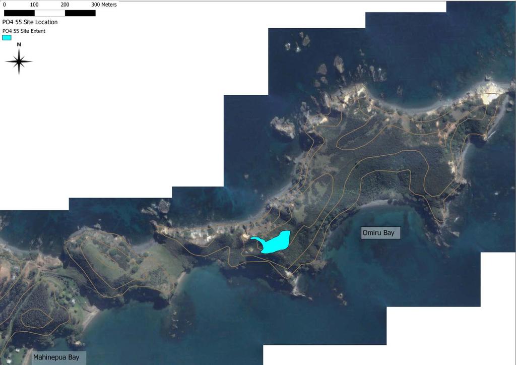
8 Figure 3: Feature map of P04/93. Recorded with a GPS Trimble Nomad with a post processed accuracy of 5m. A Blanshard DoC The largest fortified pa site recorded is P04/55 with a ditch and bank defence system that flanks the eastern and western ridge approaches (fig 4). There are also two headland pa on the north and south sides at the base of the peninsula, although these are on private land they are still considered part of the archaeological landscape of Mahinepua. The only other site of a defensive nature is a set of terraces on a small peak above PO4/93 that could have acted as a lookout or a refuge for a very small family group (P04/92). 8

9 Figure 4: Pa site Po4/55 facing south west An exposed midden on Omiru Bay was first recorded in It was described as having been 20m long and 10 50cm deep located in steep bank behind the beach. The midden was said to contain numerous shellfish and fish species, oven stones and charcoal. It was noted as non-specialised and possibly from the early or archaic period. A survey in 2009 located only a small part of this midden and it is likely to be covered over by grass or has been destroyed by coastal erosion. Volunteers mapped a portion of the remaining features of this midden in 2009 which consisted largely of fire cracked rock and small lenses of midden in parts of the beach bank, probably the remains of PO4/89. Further sites recorded on the peninsula are terraces that are spread out towards the end of the peninsula. Sites east of pa PO4/55 are small and limited for such a large area and could possibly indicate interrupted periods of occupation, or use by smaller groups. There are numerous pa sites along the Whangaroa coastline from Matauri Bay to Tauranga Bay. Additionally stone features, although not common, are present along this coastline. Mahinepua has all the archaeological features that are commonly found in this area therefore they are not considered to be rare within their wider archaeological context. The condition of the sites at Mahinepua varies but overall it is considered good. There is a diverse range of sites represented here and although there are fewer than might be expected for its location on a main water route and its environment which offered a warm climate and plentiful 9
10 seafood resources, this does not decrease its overall value and is merely a reflection on how prehistoric Maori used the landscape over time. Cultural connections Mahinepua is not referred to historically but does have indirect links to the wider historical events that are associated with this region. It is of great significance to Ngati Ruamahue Ki Mahinepua. It is also of interest to New Zealanders as part of their country s prehistory. National context The archaeology that characterises this coastline between the Whangaroa Harbour and Matauri Bay consists of pa sites, kainga, midden including archaic sites, terraces, and gardening features such as stone walls, and stone heaps and slope lines. The Whangaroa region supported a considerable Maori population with close ties to the people of the Bay of Islands. When the first Europeans arrived in the Whangaroa district it was border country with Ngati Kahu. In the early 1800 s it was claimed as Ngapuhi territory by Chief Hongi Hika. Another people in the area at this time may have been Ngati Uru who had recently migrated to the Whangaroa area from the southern part of the Bay of Islands after the killing of French explorer Marion Du Fresne in Maori settlement entered a period of instability during the 1820 s as a result of the Ngapuhi raids during the musket wars. This allowed Europeans to move into the district where the original inhabitants were forced to leave. 6 Early European history for the area tends to focus on the Boyd incident that took place in the Whangaroa Harbour in The Star sailed by Captain Wilkinson was the first known vessel to visit Whangaroa Harbour and when it left took with it a young Maori named Te Ara (George). 7 When Te Ara returned to Whangaroa in 1809 on the HMS Boyd, he complained to the Chief Te Puhi of being ill treated on the voyage. As a result the captain of the Boyd and his sailors were killed at Te Puhi s village near Kaeo. Te Puhi and his men also killed all who remained on the Boyd. As well as a tragic end for the people on the ship, Te Pahi a chief from Te Puna in the Bay of Islands who had tried to assist the people of the Boyd was killed and his village sacked. This resulted from several whalers mistakenly thinking that he was involved in the attack on the Boyd. The event destroyed relations between the Europeans living in the area and the local Maori. Later the Boyd was accidentally set on fire and drifted to a point up the harbour to the west of the township of Whangaroa, where the remains are located today. 8 10
11 Samuel Marsden and J.L Nicholas arrived at this stretch of coast on board the Active and landed in December Marsden s aim was to make peace with the people of this area who had been at war since the Boyd massacre of The brig Active was reported as anchored off the Cavalli Islands one league (5km) from the mainland and five leagues (25km) from Whangaroa (5km SE of Mahinepua Peninsula). It is suggested that this particular period of tension is reflected in the building of numerous fortified settlements along the coast. 10 In addition to providing a history of the area, the written accounts indicate the elements of subsistence along this coast. For example the Active reported that fern root was a major part of the diet, from which a sort of bread was made. Additionally, the fish offered to Cook in 1769 indicates that fish was a main component of the diet and also kumara, as its cultivation was noted by the Endeavour. The focus on fern root possibly explains the lack of pits recorded in the pa and the open settlements in the Opounui Point area, between Te Ngaere Bay and Matauri Bay. 11 It is also suggested that the lack of pits recorded in the Whangaroa district indicates that there was a focus on above-ground storage of crops. 12 The Methodist mission was established in Whangaroa in the 1820 s and 30 s and Europeans became regular visitors to the area. There was the development of timber harvesting (mainly Kauri), shipbuilding, whaling and gum digging. 13 Hongi Hika took advantage of this trading opportunity with the newly arriving European settlers. In 1826 he arrived with 400 warriors to avenge a series of insults to his wife and mother s family and to establish a new trading settlement with the Europeans. Hongi and his warriors staged themselves at Tauranga Bay before raiding the harbour in January the next year. At this time, according to historical sources, the whole of the Whangaroa population and possibly those of Mahinepua moved to their hilltop pa to live. 14 Prehistoric and historic significance The prehistoric significance of Mahinepua lies in its fabric which explains part of the prehistory of the land as it was used by early Maori. There is great potential for interpretation on this peninsula. Mahinepua is part of the rich historical region stretching from Whangaroa to the Bay of Islands and its historic significance lies within its context. Fabric significance The fabric significance of Mahinepua is wide ranging from the individual archaeological features to the landscape as a whole and its representation of New Zealand s prehistory. 11
12 Mahinepua is an example of a landscape with seemingly common archaeological features that can be analysed and interpreted and contribute to New Zealand s prehistory. The detailed recording of the sites and their features on Mahinepua is important. It is an example of how sites on DoC land should be recorded for effective management purposes. Mahinepua is significant as representative of a complete archaeological landscape Cultural significance It is of great significance to Ngati Ruamahue Ki Mahinepua, and is of importance to New Zealanders as a part of their country s early history. Management recommendations P04/55 is located on the track and has some well-defined features and therefore provides the best opportunity for public interpretation. Monitoring of the pa P04/55 where small areas are being worn by foot traffic. Monitoring of the pa sites located on private land with permission of owners to ensure their future preservation. Survey of Motuekaiti Island which is also under DoC management. The creation of Interpretation of the peninsula and the Cavalli Islands. Management chronology 1912: survey map of the peninsula and the beachfront of Mahinepua Bay that indicates parts that have been sold possibly to the Mahinepua parish. Maori Land 8414 LINZ. 1978: Mahinepua Peninsula was gazetted as a scenic reserve under Bay of Islands Maritime and Historic Park 1987: Department of Conservation took over the management 4 th September 2009: Archaeological survey and assessment for the Mahinepua Peninsula track upgrade for the Historic Places Trust. 9 th November 2009: Section 14 authority granted by the Historic Places Trust to repair and upgrade the Mahinepua peninsula track. Authority No: 2010/ th May 2010 final report for the Mahinepua Peninsula track upgrade received by the Historic Places Trust. 12
13 Management documentation Current historic DoC management file numbers: HHA NLB-1 01/01/1979; HHA NLB-1 12/02/1981; HHA NLB-1 01/03/1990; HHA NLB-1 01/07/2010 Heritage assessment: yes Baseline inspection: Archaeological survey and assessment for the Mahinepua Peninsula track upgrade. M Goddard and A Blanshard, Department of Conservation Bay of Islands area office Sources Ashby, E., Constructing syntheses of CRM and academic based archaeologies: A case study of Mahinepua peninsula scenic reserve. A thesis submitted in the fulfilment for the degree of Master of Arts in Anthropology. University of Auckland. Carpenter, J Archaeological Survey and Assessment of Lot DP , Butterfly Bay, Whangaroa District. Northern Archaeological Research. Cloher, D.U Hongi Hika: Warrior chief. Penguin Books, Auckland. Department of Conservation, The story of the Bay of Islands Maritime and Historic Park. Published by Bay of Islands Maritime and Historic Park. Fox, A Report on the Archaeology of the Parua Bay District, Whangaroa, Northland. Auckland Museum Maingay, J Initial Report on Northland Archaeology. Unpublished report for the Historic Places Trust. Salmond, A Two Worlds: First meetings between Maori and European Penguin books, Auckland, New Zealand. 13
14 Appendix NEW ZEALAND ARCHAEOLOGICAL ASSOCIATION SITE RECORD FORM (NZMS260) NZAA METRIC SITE NUMBER PO4/93 DATE VISITED 04/06/09 NZMS 260 map number PO4 SITE TYPE Terrace and gardening site SITE NAME: MAORI NZMS 260 map name Whangaroa OTHER NZMS 260 map edition 2000 Grid Reference Easting Northing Aids to relocation of site (attach a sketch map) Mahinepua peninsula, Northland. Peninsula overlooks the Cavalli islands. Site located in the first valley which has two sandy beaches on either side. The site was recorded using a Trimble Nomad GPS which allowed a post processed accuracy of 98% >5m. All GPS points are in New Zealand Traverse Mercator Projection, based on the NZ2000 Datum. 2. State of site and possible future damage Located in thick Kikuyu, patches of gorse and mixed shrub. Terraces and drains in good condition. At risk from erosion processes and visitor impacts 3. Description of site (Supply full details, history, local environment, references, sketches, etc. If extra sheets are attached, include a summary here) This site was recorded in 1976 as a field system consisting of three garden drains running down the north western slope of the valley. Further recorded indicators of gardening in this valley are the remains of stones walls and stone heaps. Two stone walls were recorded on the foothill of the eastern slope of the valley. This included a rubbly area and two stone heaps that were recorded on the southern end of the valley. A single terrace described as stone faced was recorded on the eastern slope. In the valley bottom a long depression that runs from the beach on the southern end of the valley for 80m across until it fades out some 50m from the beach on the north end. Oral traditions state that this was a portage used by the ancestors who would drag their canoes from one bay to another. This site was relocated and updated in Twelve previously unrecorded terraces were found running down the eastern slope of the valley. Due to the length and thickness of the Kikuyu a probe was used to relocate the two stone walls and rubbly area recorded in One wall like area of stones was found near the place recorded in To the north of this the area was probed and a further four raised stone areas were located and their extents were recorded by GPS. These stone mounds begin directly at the foot of the slope and finish approximately 1-2m from the portage line. Further up the eastern slope to the right of the walking track an area of stones and large rocks have been recorded. This is possibly a natural occurrence that may have rolled down the steep eastern slope of pinnacle peak. A total of seven well defined gardening lines were recorded on the northern end of the western valley slope. One of which runs down to a well defined terrace and another that runs out the side of the terrace. Above the gardening lines are five terraces some of them small suggesting possible use for gardening. The three gardening lines recorded on the southern end of the western slope could not be differentiated between the grass walking tracks that are currently in use here. In addition areas of gorse are obscuring parts of this slope (as shown in the shaded area). The portage recorded in 1976 cuts across the entire valley bottom and its use as a track today has assisted in its current definition. 4. Owner Department of Conservation Address Bay of Islands area office, Po box, 128, Kerikeri Tenant/Manager Address 5. Nature of information (hearsay, brief or extended visit, etc.) Brief Photographs (reference numbers and where they are held) Held in the Department of Conservation BOI Area Office Aerial photographs (reference numbers and clarity of site) Google 14

15 15
16 NEW ZEALAND ARCHAEOLOGICAL ASSOCIATION SITE RECORD FORM (NZMS260) NZMS 260 map number PO4 NZMS 260 map name Whangaroa NZMS 260 map edition 2000 Grid Reference NZTM Easting Northing Aids to relocation of site (attach a sketch map) Mahinepua peninsula, Northland. Located on prominent hilltop east of PO4/91 NZAA METRIC SITE NUMBER PO4/55 DATE VISITED may 2009 SITE TYPE PA SITE NAME: MAORI OTHER 2. State of site and possible future damage Site located in long grass, features are in good condition. Site is under no immediate threat. The site was recorded using a Trimble Nomad GPS which allowed a post processed accuracy of 98% >5m. All GPS points are in New Zealand Traverse Mercator Projection, based on the NZ2000 Datum. 3. Description of site (Supply full details, history, local environment, references, sketches, etc. If extra sheets are attached, include a summary here) This hilltop was recorded in 1976 as having ditch and bank defence systems which were found to flank the ridge approaches on the north, east, south and west sides. Inside the ditch and bank systems there were two pits recorded, three terraces and two shallow depressions. On the east facing ridge four terraces were found extending beyond the defence. One of the terraces has a pit cut into it and also a narrow trench running along the terrace back. This site was relocated and updated in The southern side of the pa covered in scrub and therefore further features were not able to be located. At the highest point of the hill a tihi (platform) was recorded. On its western slope the tihi steps down directly onto a terrace. This terrace is then followed by a ditch and three more terraces, one of which is undefined. On the south western side of the platform is a pit followed by a terrace. The northern slope from the tihi is a pit which has two terraces either side this set is then followed by a single terrace. On its eastern slope the tihi drops down to a ditch which is then followed by six terraces three of which are orientated to the north. The density of features for this site are located on the eastern and western slopes. The eastern terraces look towards the Cavalli Islands and the western terraces look towards Stephenson Island and beyond. 4. Owner Department of Conservation Address Bay of Islands area office, P0 box 128, Kerikeri Tenant/Manager Address 5. Nature of information (hearsay, brief or extended visit, etc.) Brief Photographs (reference numbers Held in the Department of Conservation BOI Area Office and where they are held) Aerial photographs (reference numbers and clarity of site) Google 6. Reported by A. Blanshard M.Goddard Filekeeper Address Bay of Islands area office, P0 box 128, Kerikeri Date 7. Key words 16

17 17
18 NEW ZEALAND ARCHAEOLOGICAL ASSOCIATION NZAA METRIC SITE NUMBER PO4/92 SITE RECORD FORM (NZMS260) DATE VISITED 04/06/09 NZMS 260 map number PO4 SITE TYPE terraces on peak SITE NAME: MAORI NZMS 260 map name Whangaroa OTHER NZMS 260 map edition 2000 Grid Reference Easting Northing Aids to relocation of site (attach a sketch map) Mahinepua peninsula, Northland. Located on pinnacle peak east of PO4/ State of site and possible future damage Features are well defined and located in short grass. The northern side of the pa is exposed and actively eroding. The site was recorded using a Trimble Nomad GPS which allowed a post processed accuracy of 98% >5m. All GPS points are in New Zealand Traverse Mercator Projection, based on the NZ2000 Datum. 3. Description of site (Supply full details, history, local environment, references, sketches, etc. If extra sheets are attached, include a summary here) This site was recorded in 1976 as six small terraces on the top and side of a narrow ridge top. This site was relocated and updated in 2009 and a total of seven terraces and a tihi (platform) were recorded. This site is well defended on all sides by steep scarps on either sides and has 360 degree views. As interpreted in 1976 the terraces are too small for long term habitation and are likely to be of a defensive nature. This site would have acted as a lookout and possibly as a refuge for a small group living in the area. Possibly associated to terraces of PO4/93 which run further down the western slope of PO4/ Owner Department of Conservation Address Bay of Islands area office PO box 128, Kerikeri Tenant/Manager Address 5. Nature of information (hearsay, brief or extended visit, etc.) Brief visit Photographs (reference numbers Google and where they are held) Aerial photographs (reference numbers and clarity of site) Held in the Department of Conservation BOI Area Office 6. Reported by A. Blanshard M. Goddard Filekeeper Address DOC PO box 128 Kerikeri Date 7. Key words 18

19 19
20 NEW ZEALAND ARCHAEOLOGICAL ASSOCIATION NZAA METRIC SITE NUMBER P04/91 SITE RECORD FORM (NZMS260) DATE VISITED June 2009 NZMS 260 map number PO4 SITE TYPE Terraces SITE NAME: MAORI NZMS 260 map name Whangaroa OTHER NZMS 260 map edition 2000 Grid Reference Easting Northing Aids to relocation of site (attach a sketch map) Mahinepua peninsula, Northland. On the south facing side of narrow saddle immediately beyond the high pinnacle shaped peak (P04/92). The site was recorded using a Trimble Nomad GPS which allowed a post processed accuracy of 98% >5m. All GPS points are in New Zealand Traverse Mercator Projection, based on the NZ2000 Datum. 2. State of site and possible future damage Site located in long grass and bush. Northern face of slope actively eroding. 3. Description of site (Supply full details, history, local environment, references, sketches, etc. If extra sheets are attached, include a summary here) Site recorded in 1976 as four small terraces on south facing slope overlooking Mahinepua Bay. Of the four terraces only two were relocated in the 2009 survey. Further terraces are likely to be present in the thick vegetation as indicated on the survey map. 4. Owner Department of Conservation Address Bay of Islands area office Po box 128, Kerikeri Tenant/Manager Address 5. Nature of information (hearsay, brief or extended visit, etc.) Brief visit Photographs (reference numbers Google and where they are held) Aerial photographs (reference numbers and clarity of site) Held in the Department of Conservation BOI Area Office 6. Reported by M. Goddard Filekeeper Address DOC Po box 128, Kerikeri Date 7. Key words 20


21 21
22 NEW ZEALAND ARCHAEOLOGICAL ASSOCIATION NZAA METRIC SITE NUMBER P04/90 SITE RECORD FORM (NZMS260) DATE VISITED June 2009 NZMS 260 map number PO4 SITE TYPE Terraces NZMS 260 map name Whangaroa SITE NAME: MAORI OTHER NZMS 260 map edition 2000 Grid Reference Easting Northing Aids to relocation of site (attach a sketch map) Mahinepua peninsula, Northland. Located on the northern side near the end of the peninsula. On a small narrow ridge. The site was recorded using a Trimble Nomad GPS which allowed a post processed accuracy of 98% >5m. All GPS points are in New Zealand Traverse Mercator Projection, based on the NZ2000 Datum. 2. State of site and possible future damage Located in patches of thick scrub and long grass. Poorly defined and slumped in areas. 3. Description of site (Supply full details, history, local environment, references, sketches, etc. If extra sheets are attached, include a summary here) Recorded in 1976 as three terraces and four shallow depressions (possible pits), on a narrow sloping ridge top. The 2009 survey relocated this site and recorded four terraces and a possible platform. The large terrace and platform recorded on the tip of the headland are obscured by thick scrub and therefore limited the interpretation of the features. No pits were recorded as their presence could not be confirmed on the surface. 4. Owner Department of Conservation Address Bay of Islands area office, PO box 128, Kerikeri Tenant/Manager Address 5. Nature of information (hearsay, brief or extended visit, etc.) Brief visit Photographs (reference numbers Held in the Department of Conservation BOI Area Office and where they are held) Aerial photographs (reference numbers and clarity of site) Google 6. Reported by M.Goddard Filekeeper Address DOC, Po box 128, Kerikeri Date 7. Key words 22


23 23
24 NEW ZEALAND ARCHAEOLOGICAL ASSOCIATION NZAA METRIC SITE NUMBER P04/105 SITE RECORD FORM (NZMS260) DATE VISITED June 2009 NZMS 260 map number PO4 SITE TYPE Pit and terrace SITE NAME: MAORI NZMS 260 map name Whangaroa OTHER NZMS 260 map edition 2000 Grid Reference Easting Northing Aids to relocation of site (attach a sketch map) Mahinepua peninsula, Northland. Site located on top of the slope to the west of P04/93. The site was recorded using a Trimble Nomad GPS which allowed a post processed accuracy of 98% >5m. All GPS points are in New Zealand Traverse Mercator Projection, based on the NZ2000 Datum. 2. State of site and possible future damage Site covered in thick, high Kikuyu grass which made locating features difficult. Features that were visible were in good condition. 3. Description of site (Supply full details, history, local environment, references, sketches, etc. If extra sheets are attached, include a summary here) Site recorded in 1976 as a pit and terrace site. Features located in 2009 were two pits and four terraces. The bulk of the features were recorded on the northern most end of the hilltop, with terraces running down the hillside. Further features more than likely exist but are obscured by thick kikuyu which is the area indicated on the map as the shaded portion. 4. Owner Department of Conservation Address Bay of Islands area office, PO box 128, Kerikeri. Tenant/Manager Address 5. Nature of information (hearsay, brief or extended visit, etc.) Brief visit Photographs (reference numbers and where they are held) Held in the Department of Conservation BOI Area Office Aerial photographs (reference numbers and clarity of site) Google 6. Reported by A. Blanshard M.Goddard Filekeeper Address DOC, PO box 128, Kerikeri Date 7. Key words 24


25 25
26 NEW ZEALAND ARCHAEOLOGICAL ASSOCIATION NZAA METRIC SITE NUMBER P04/730 SITE RECORD FORM (NZMS260) DATE VISITED June 2009 NZMS 260 map number PO4 SITE TYPE Terraces SITE NAME: MAORI NZMS 260 map name Whangaroa OTHER NZMS 260 map edition 2000 Grid Reference Easting Northing Aids to relocation of site (attach a sketch map) Mahinepua peninsula, Northland. Located on a hilltop directly east of the pa P04/55. The site was recorded using a Trimble Nomad GPS which allowed a post processed accuracy of 98% >5m. All GPS points are in New Zealand Traverse Mercator Projection, based on the NZ2000 Datum. 2. State of site and possible future damage Area covered in thick long Kikuyu. In ok condition. 3. Description of site (Supply full details, history, local environment, references, sketches, etc. If extra sheets are attached, include a summary here) Located in the 2009 survey. Area rises up from a small saddle and is relatively flat and wide. Two terraces were located on the western edge. One of them is small and may have been used largely for defensive purposes rather than as a living terrace. This terrace is situated against a possible platform area. An eastern edge for this platform was not found and as it gradually slopes downwards. A larger terrace was located near the current track to the south of these features. Thick, long kikuyu is obscuring any further features which are likely to exist in this area. Due to the growth of the kikuyu an accurate interpretation of the platform and the location of its edges could not be made. It is possible that this platform is in fact a terrace. 4. Owner Department of Conservation Address Bay of islands area office, PO box 128, Kerikeri Tenant/Manager Address 5. Nature of information (hearsay, brief or extended visit, etc.) brief Photographs (reference numbers Held in the Department of Conservation BOI Area Office and where they are held) Aerial photographs (reference numbers and clarity of site) Google 6. Reported by A. Blanshard M. Goddard Filekeeper Address DOC PO box 128, Kerikeri Date 7. Key words 26


27 27
28 NEW ZEALAND ARCHAEOLOGICAL ASSOCIATION NZAA METRIC SITE NUMBER P04/731 SITE RECORD FORM (NZMS260) DATE VISITED June 2009 NZMS 260 map number P04 SITE TYPE Terraces SITE NAME: MAORI NZMS 260 map name Whangaroa OTHER NZMS 260 map edition 2000 Grid Reference NZTM Easting Northing Aids to relocation of site (attach a sketch map) Mahinepua peninsula, Northland. Located on a hilltop to the north of the eastern slope of P04/93. The site was recorded using a Trimble Nomad GPS which allowed a post processed accuracy of 98% >5m. All GPS points are in New Zealand Traverse Mercator Projection, based on the NZ2000 Datum. 2. State of site and possible future damage In good condition. Located in grass and scrub patches. Continuing erosion on the northern cliff face. 3. Description of site (Supply full details, history, local environment, references, sketches, etc. If extra sheets are attached, include a summary here) Site located in the 2009 survey. Two terraces recorded on the hilltop possibly associated to P04/93. The uppermost terrace overlooks the sea to the north and P04/93. The lower terrace is located on the southern side of the hill facing towards P04/ Owner Department of Conservation Address Bay of islands area office, PO box 128, Kerikeri Tenant/Manager Address 5. Nature of information (hearsay, brief or extended visit, etc.) Brief Photographs (reference numbers Held in the Department of Conservation BOI Area Office and where they are held) Aerial photographs (reference numbers and clarity of site) Google 6. Reported by A. Blanshard M. Goddard Filekeeper Address DOC PO box 128, Kerikeri Date 7. Key words 28


29 29
30 NEW ZEALAND ARCHAEOLOGICAL ASSOCIATION NZAA METRIC SITE NUMBER P04/89 SITE RECORD FORM (NZMS260) DATE VISITED 08/06/ 2009 NZMS 260 map number PO4/89 SITE TYPE Midden SITE NAME: MAORI NZMS 260 map name Whangaroa OTHER NZMS 260 map edition 2000 Grid Reference NZTM Easting Northing Aids to relocation of site (attach a sketch map) Mahinepua Peninsula, Northland. Located on the beach front at Omiru Bay on the south side of Mahinepua peninsula The site was recorded using a Trimble Nomad GPS which allowed a post processed accuracy of 98% >5m. All GPS points are in New Zealand Traverse Mercator Projection, based on the NZ2000 Datum. 2. State of site and possible future damage Site located on exposed and eroded beachfront bank. Midden intact but subject to severe continuing coastal erosion. 3. Description of site (Supply full details, history, local environment, references, sketches, etc. If extra sheets are attached, include a summary here) This site was recorded in 1979 as being a 20m long and 10 50cm deep midden located in steep bank behind the beach. The midden was said to contain numerous shellfish and fish species, oven stones and charcoal. The midden was noted as non-specialised and possibly from the early or archaic period. This particular site as described could not be relocated during survey in However, one thin section of midden was located on the beach front on an eroded face which is approximately 1.5m long with a lens approximately 50mm-100mm thick. Fire cracked rock and shellfish similar to those described in the 1979 survey were observed as well as ash and charcoal deposits. It is possible that this section of midden is a degraded part of the one recorded in the 70 s, as the bank on either side of this exposed section is covered in thick kikuyu grass and thus any possible continuation of midden obstructed from view. It may also be the case that over the last thirty years ongoing coastal erosion has destroyed much of what was previously recorded. Map displays two areas of exposed midden and one area of fire cracked rock located to the west. 4. Owner Department of Conservation Tenant/Manager Address Bay of Islands Area Office PO Box, 128, Kerikeri Address 5. Nature of information (hearsay, brief or extended visit, etc.) Brief Photographs (reference numbers Held in the Department of Conservation Area Office and where they are held) Aerial photographs (reference numbers and clarity of site) Google 6. Reported by Edward Ashby, maps and photo by Blanshard, A. Goddard. M. Filekeeper Date Address DOC PO box 128, Kerikeri 7. Key words 8. New Zealand Register of Archaeological Sites (for office use) NZHPT Site Field Code 30


31 31
32 Endnotes 1 Ashby 2009:107 2 ibid 3 Salmond 1991: op.cit Ashby:107 5 Fox 1975:16 6 Carpenter 2004:7 7 Department of Conservation 1989:91 8 ibid 9 Op.cit Fox:16 10 ibid 11 Op.cit Fox:13 12 Maingay 1986: Op.cit Department of Conservation:92 14 Cloher 2003:
Waewaetorea Island. Historic Heritage Assessment Bay of Islands Area Office. Melina Goddard 2012
 Waewaetorea Island Historic Heritage Assessment Bay of Islands Area Office Melina Goddard 2012 Waewaetorea Island Scenic Reserve Historic Heritage Assessment Melina Goddard, DoC, Bay of Islands Area Office
Rangikapiti Pa Historic Reserve
 Rangikapiti Pa Historic Reserve Historic Heritage Assessment Kaitaia Area Office Melina Goddard 2011 5 Rangikapiti Pa: Historic Heritage Assessment Melina Goddard, DoC, Kaitaia Area Office 2011 Cover image:
Araiteuru Recreation Reserve
 Araiteuru Recreation Reserve Historic Heritage Assessment Kauri Coast Area Office Melina Goddard 2010 Araiteuru: Historic Heritage Assessment Melina Goddard, DoC, Kauri Coast Area Office 2010 Cover image:
ARCHAEOLOGICAL SITES ON SMALL ISLANDS IN THE EASTERN BAY OF ISLANDS, NORTHLAND. by Bruce W. Hayward* and A.E. Wright SUMMARY
 TANE 26, 1980 ARCHAEOLOGICAL SITES ON SMALL ISLANDS IN THE EASTERN BAY OF ISLANDS, NORTHLAND by Bruce W. Hayward* and A.E. Wright * N.Z. Geological Survey, P.O. Box 30-368, Lower Hutt t Department of Botany,
9.2.1 Organised groups and settlement during the main period of prehistoric Maori occupation
 Figure 5. Distribution of pa and pit sites in the Bay of Plenty region. 9.2.1 Organised groups and settlement during the main period of prehistoric Maori occupation The broad pattern of Maori occupation
ARCHAEOLOGICAL SITE SURVEY ON PONUI ISLAND, HAURAKI GULF, NEW ZEALAND. by Peter J. Matthews SUMMARY
 TANK 25, 1979 ARCHAEOLOGICAL SITE SURVEY ON PONUI ISLAND, HAURAKI GULF, NEW ZEALAND by Peter J. Matthews 3 Sadgrove Terrace, Mount Albert, Auckland 3 SUMMARY Thirty four archaeological sites were recorded
Unlocking Our Coastal Heritage Project: Crane Castle Promontory Fort, Illogan, Cornwall
 Unlocking Our Coastal Heritage Project: Crane Castle Promontory Fort, Illogan, Cornwall As part of a wider project funded by the Rural Development Programme for England (RDPE) and administered through
Ohakiri Pa. St Paul s Rock Scenic Reserve. Historic Heritage Assessment. Melina Goddard 2011
 Ohakiri Pa St Paul s Rock Scenic Reserve Historic Heritage Assessment Melina Goddard 2011 Ohakiri Pa: St Paul s Rock Scenic Reserve Historic Heritage Assessment Melina Goddard, DoC, Bay of Islands Area
Tapeka Pa Heritage Assessment
 1 Tapeka Pa Heritage Assessment Jonathan Carpenter Geometria Ltd June 2012 2 Contents Site Overview... 3 History Description... 5 Fabric Description... 9 Cultural Connections... 13 National Context Sources...
Channel Islands Occupation Society
 INTRODUCTION The subject of the Conservation Statement is Kempt Tower, built in 1834 in St Ouen s Bay, Jersey. The primary purpose of the statement is to draw together existing information, to set down
7. Poverty Bay and East Coast
 7. Poverty Bay and East Coast The first fighting in the Poverty Bay and East Coast regions took place in 1865 at Tokomaru Bay, Waiapu and Hicks Bay, mostly between sections of the Ngāti Porou tribe (Cowan
Contents. Cover Image: O04/14 Te Homumu Pa from Coopers Beach.
 2 Contents Site Overview... 3 History Description... 3 Fabric Description... 6 Cultural Connections... 18 National Context Sources... 18 Historic Significance... 18 Fabric Significance... 19 Cultural Significance...
Chapter 7 Geography and the Early Settlement of Egypt, Kush, and Canaan
 Chapter 7 Geography and the Early Settlement of Egypt, Kush, and Canaan How did geography affect early settlement in Egypt, Kush, and Canaan? Section 7.1 - Introduction RF/NASA//Corbis This satellite photograph
Island Bay Foreshore: Archaeological Issues
 Island Bay Foreshore: Archaeological Issues arczoo Ltd, PO Box 14 575, WELLINGTON ph 04 388 5338 email aczoo@paradise.net.nz Prepared for Wellington City Council February 2005 1 Introduction Wellington
Chapter 7: The Geography and Settlement of Egypt, Kush, and Canaan
 Chapter 7: The Geography and Settlement of Egypt, Kush, and Canaan Learning Target: I can explain how geography affected early settlement in Egypt, Kush, and Canaan. Ancient Egypt and the Middle East Can
Archaeological and Historic Sites Sites of Significance Wairarapa Water Use Project
 Archaeological and Historic Sites Sites of Significance Wairarapa Water Use Project 18 May 2015 Christine Barnett Archaeological Interpretation 9 Fairway Drive Martinborough New Zealand 5711 ph 06 306
Chapter 7. Geography and the Early Settlement of Egypt, Kush, and Canaan
 Chapter 7 Geography and the Early Settlement of Egypt, Kush, and Canaan Chapter 7 Geography and the Early Settlement of Egypt, Kush, and Canaan How did geography affect early in Egypt Kush, and Canaan?
The Year in Review 2014, Beothuk Institute Inc. We have had several highlights this year. At the AGM in May there were two guest speakers, Dale
 The Year in Review 2014, Beothuk Institute Inc. We have had several highlights this year. At the AGM in May there were two guest speakers, Dale Jarvis set the stage for the story gathering that the Beothuk
FOUNDATIONS OF ARCHAEOLOGY A WALK IN VERNDITCH CHASE
 FOUNDATIONS OF ARCHAEOLOGY A WALK IN VERNDITCH CHASE 1. A Tale of two Long Barrows Long barrows were constructed as earthen or drystone mounds with flanking ditches and acted as funerary monuments during
Ancient Egypt and the Near East
 *O*»f ' i ft Ancient Egypt and the Near East Chapter 7 Chapter 8 Chapter 9 Geography and the Early Settlement of Egypt, Kush, and Canaan The Ancient Egyptian P h a r a o h s Daily Life in Ancient Egypt
Appendix: : Background Information for Rangihoua
 Rangihoua Historic Area Rangihoua And Wairoa Bays, Purerua Peninsula, Bay Of Islands Rangihoua Historic Area. Copyright: Heritage New Zealand. Rangihoua Historic Area. Marsden Cross. Copyright: Heritage
Cholesbury New House, Parrots Lane, Cholesbury, Buckinghamshire
 Cholesbury New House, Parrots Lane, Cholesbury, Buckinghamshire An Archaeological Watching Brief For Mr Martin Wood by Sean Wallis Thames Valley Archaeological Services Ltd Site Code PLC 06/135 March 2007
Introduction to Map 30: Sgeir Alt Mhic Eoghainn to Ton Loisgte
 Introduction to : Sgeir Alt Mhic Eoghainn to Ton Loisgte This map section covers some 7.8km of coastline. This section takes in the south western facing butt of the Rhinns and includes the villages of
KP Lasnaya 1 River
 KP 370.2 Lasnaya 1 River The Lasnaya 1 River crossing is protected by Reno mattings and a gabion wall on the north bank (Photo 1). The south bank consists of natural river gravel deposits on top of Reno
Specification for Grip blocking using Peat Dams
 Technical Guidance Note 1 Specification for Grip blocking using Peat Dams 1. Introduction Moorland drains (grips) have been dug across much of the Yorkshire upland peatlands. Many of these grips have become
1 INFORMATION REQUIREMENTS
 1 INFORMATION REQUIREMENTS 1.1 BACKGROUND 2 1.2 WHAT IS THE DISTRICT PLAN 3 1.3 DISTRICT PLAN STRUCTURE 4 1.4 HOW TO USE THE DISTRICT PLAN 5 1.5 STRATEGIC FRAMEWORK 6 Whanganui District Plan (15 January
Kicking the Alpine Plants Out Mountain Goat Wallows In Mount Peale Research Natural Area (La Sal Mountains, Utah)
") Kicking the Alpine Plants Out Mountain Goat Wallows In Mount Peale Research Natural Area (La Sal Mountains, Utah) Marc Coles-Ritchie, Grand Canyon Trust November 21, 2017 Mountain goats are digging up
Kicking the Alpine Plants Out Mountain Goat Wallows In Mount Peale Research Natural Area (La Sal Mountains, Utah) Marc Coles-Ritchie, Grand Canyon Trust November 21, 2017 Mountain goats are digging up
ARCHAEOLOGY IN TUCSON
 ARCHAEOLOGY IN TUCSON Vol.1, No.4 Newsletter of the Institute for American Research Summer 1987 TRULY THE ORIGINAL TUCSON! In our last AIT newsletter, we presented some of the background about the San
United States Department of the Interior National Park Service. Boundary Expansion Listed in National Register January 11, 2017
 NPS Form 10900-a (Rev. 8/2002) OMB No. 10240018 United States Department of the Interior National Park Service Boundary Expansion Listed in National Register January 11, 2017 National Register of Historic
Level 1 Geography, 2017
 1 91010R Level 1 Geography, 2017 91010 Apply concepts and basic geographic skills to demonstrate understanding of a given environment 9.30 a.m. Thursday 23 November 2017 Credits: Four RESOURCE BOOKLET
NECHAKO CANYON PROTECTED AREA
 NECHAKO CANYON PROTECTED AREA PURPOSE STATEMENT AND ZONING PLAN March 2003 1 Nechako Canyon Protected Area Purpose Statement and Zoning Plan The Nechako Canyon Protected Area (1,246 hectares) is located
CASTLE OF OLD WICK HISTORIC ENVIRONMENT SCOTLAND STATEMENT OF SIGNIFICANCE. Property in Care(PIC) ID: PIC282 Designations:
 ID: PIC282 Designations:") Property in Care(PIC) ID: PIC282 Designations: Scheduled Monument (SM90065) Taken into State care: 1957 (Guardianship) Last reviewed: 2004 HISTORIC ENVIRONMENT SCOTLAND STATEMENT OF SIGNIFICANCE CASTLE
Property in Care(PIC) ID: PIC282 Designations: Scheduled Monument (SM90065) Taken into State care: 1957 (Guardianship) Last reviewed: 2004 HISTORIC ENVIRONMENT SCOTLAND STATEMENT OF SIGNIFICANCE CASTLE
The Geological Pacific Northwest. Wednesday February 6, 2012 Pacific Northwest History Mr. Rice
 The Geological Pacific Northwest Wednesday February 6, 2012 Pacific Northwest History Mr. Rice 1 Free Response #2 Please do not simply list the items for this response. Full sentences!!! Minimum of 3-5
DAMAGE ASSESSMENT OF SAND FENCING GARDEN CITY, NORTH LITCHFIELD AND LITCHFIELD BEACH GEORGETOWN COUNTY, SC
 OF SAND FENCING GARDEN CITY, NORTH LITCHFIELD AND LITCHFIELD BEACH GEORGETOWN COUNTY, SC June 07, 2017 PREPARED FOR: GEORGETOWN COUNTY DEPARTMENT OF PUBLIC SERVICES PREPARED BY: The EARTHWORKS Group 11655
Remote Sensing into the Study of Ancient Beiting City in North-Western China
 Dingwall, L., S. Exon, V. Gaffney, S. Laflin and M. van Leusen (eds.) 1999. Archaeology in the Age of the Internet. CAA97. Computer Applications and Quantitative Methods in Archaeology. Proceedings of
Settlement Patterns West of Ma ax Na, Belize
 SETTLEMENT PATTERNS WEST OF MA AX NA, BELIZE 1 Settlement Patterns West of Ma ax Na, Belize Minda J. Hernke Faculty Sponsor: Kathryn Reese-Taylor, Department of Sociology/Archaeology ABSTRACT The focus
Gorse Stacks, Bus Interchange Excavations Interim Note-01
 Gorse Stacks, Bus Interchange Excavations 2015 Prepared for: Cheshire West & Chester Council Interim Note-01 1 Introduction & Summary Background Since c. 2000 investigations associated with redevelopment
New Zealand Hydrographic Authority HYPLAN. Version April 2017
 New Zealand Hydrographic Authority Version 1.0 18 April 2017 This page is intentionally blank Land Information New Zealand Crown Copyright 18 April 2017 2 Preface The following document is certified by
Chapter 25 Geography and the Settlement of Greece. How did geography influence settlement and way of life in ancient Greece?
 Chapter 25 Geography and the Settlement of Greece 25.1 Introduction How did geography influence settlement and way of life in ancient Greece? Tal Naveh/Shutterstock The ancient Greeks learned to use the
GISBORNE DISTRICT COUNCIL BUSINESS CASE PROPOSAL. Eastland Port Access. Pedestrian Safety Rakaiatane Rd. Page 1 of 4
 GISBORNE DISTRICT COUNCIL BUSINESS CASE PROPOSAL Eastland Port Access Pedestrian Safety Rakaiatane Rd Page 1 of 4 Introduction This proposal has been developed by Gisborne District Council (GDC) to provide
ARCHAEOLOGICAL SITES OF THE TE HENGA DISTRICT, WAITAKERE RANGES, WEST AUCKLAND. by Bruce W. Hayward* and John T. Diamond SUMMARY
 TANE 23, 1977 ARCHAEOLOGICAL SITES OF THE TE HENGA DISTRICT, WAITAKERE RANGES, WEST AUCKLAND by Bruce W. Hayward* and John T. Diamond *35A Mariri Road, Onehunga, Auckland, 6. f Research Secretary, Auckland
MONTAGUE HARBOUR MARINE PROVINCIAL PARK
 MONTAGUE HARBOUR MARINE PROVINCIAL PARK PURPOSE STATEMENT AND ZONING PLAN March 2003 1 MONTAGUE HARBOUR MARINE PROVINCIAL PARK Purpose Statement and Zoning Plan Primary Role The primary role of Montague
Introduction to Map 14: Fionn-phort to Caol Ila
 Introduction to Map 4: Fionn-phort to Caol Ila This map section covers some 3.8km of coastline. In the southern and central part of this section the landscape is dominated by open moorland, with scrub
Park-specific management and policies Wainuiomata Recreation Area
 Park-specific management and policies Wainuiomata Recreation Area 6.8 Wainuiomata Recreation Area 6.8.1 Legal status Title held: Legislative status: Wellington Regional Council Administered under Local
CULTURAL HERITAGE RESOURCES IMPACT ASSESSMENT ON MALOKONG HILL
 CULTURAL HERITAGE RESOURCES IMPACT ASSESSMENT ON MALOKONG HILL AFRICAN HERITAGE CONSULTANTS CC 2001/077745/23 Tel/fax: (012) 567 6046 Cell: 082 498 0673 E-mail: udo.heritage@absamail.co.za DR. UDO S KÜSEL
Wheatlands House, Fleet Hill, Finchampstead, Berkshire
 Wheatlands House, Fleet Hill, Finchampstead, Berkshire An Archaeological Watching Brief For JCA International by James McNicoll-Norbury Thames Valley Archaeological Services Ltd Site Code WFF 08/26 August
The Maltese Islands: Geography
 The Maltese Islands: Geography The Maltese Archipelago comprises a group of small low islands aligned in a NW-SE direction. At their extreme points the Maltese Islands fall within the following points:
The Atlas of Hillforts of Britain and Ireland. Hillfort survey notes for guidance
 The Atlas of Hillforts of Britain and Ireland Hillfort survey notes for guidance The collection of surveys for the Atlas is now finished but you can use this form and the accompanying Notes for Guidance
THRESHOLD GUIDELINES FOR AVALANCHE SAFETY MEASURES
 BRITISH COLUMBIA MINISTRY OF TRANSPORTATION & INFRASTRUCTURE AVALANCHE & WEATHER PROGRAMS THRESHOLD GUIDELINES FOR AVALANCHE SAFETY MEASURES British Columbia Ministry of Transportation & Infrastructure
Survey of Littleton Down
 Survey of Littleton Down 05 November 2014 The Team: John and Jenny Barnard 1) Introduction Littleton Down (Hill Number 2911, Section 42, OS 1:50000 Map 197, OS 1:25000 Map 121, Grid Ref. SU941150) is listed
The Coach House, Mill Lane, Cookham, Berkshire
 The Coach House, Mill Lane, Cookham, Berkshire An Archaeological Watching Brief For Ms Sophia Butler by Stephen Hammond Thames Valley Archaeological Services Ltd Site Code CMC 03/104 October 2003 Summary
PLUMPER COVE MARINE PARK MASTER PLAN
 Lower Mainland Region Park Operations Branch Parks and Outdoor Recreation Division Ministry of Lands, Parks and Housing North Vancouver, B.C. PLUMPER COVE MARINE PARK MASTER PLAN DECEMBER, 1980 PLUMPER
USDA Trails Strategy WRI: ENGLISH PEAK SURVEY. Theodore Mendoza San Diego State University June 6 th 2016 August 18 th Advisor: Sam Commarto
 WRI: ENGLISH PEAK SURVEY Theodore Mendoza San Diego State University June 6 th 2016 August 18 th 2016 Advisor: Sam Commarto Klamath National Forest Submitted: March 21, 2017 Table of Contents Acknowledgements
ARDESTIE EARTH HOUSE HISTORIC ENVIRONMENT SCOTLAND STATEMENT OF SIGNIFICANCE. Property in Care no: 24
 Property in Care no: 24 Designations: Scheduled Monument (SM90021) Taken into State care: 1953 (Guardianship) Last reviewed: 2004 HISTORIC ENVIRONMENT SCOTLAND STATEMENT OF SIGNIFICANCE ARDESTIE EARTH
Architectural Analysis in Western Palenque
 Architectural Analysis in Western Palenque James Eckhardt and Heather Hurst During the 1999 season of the Palenque Mapping Project the team mapped the western portion of the site of Palenque. This paper
Holyport Manor Special School, Highfield Lane, Cox Green, Maidenhead, Berkshire
 Holyport Manor Special School, Highfield Lane, Cox Green, Maidenhead, Berkshire An Archaeological recording action For CgMs Consulting by Jennifer Lowe Thames Valley Archaeological Services Ltd Site Code
Wicklow Mountains Path Survey
 Wicklow Mountains Path Survey Glenmacnass Tonelagee Start to Finish: O 114 030 to O 085 016 Altitude (lowest highest): 370m 817m Weather: Sunny day, hot Access: Military Road, Glenmacnass Surveyed by:
Brain Wrinkles. Africa: The impact of location, climate, & physical characteristics on where people live, the type of work they do, & how they travel
 Africa: The impact of location, climate, & physical characteristics on where people live, the type of work they do, & how they travel STANDARDS: SS7G3 The student will explain the impact of location, climate,
Hawke s Bay Regional Parks Network. Pekapeka Regional Park Individual Park Plan
 Hawke s Bay Regional Parks Network Pekapeka Regional Park Individual Park Plan 2015-2024 Hawke s Bay Regional Council 159 Dalton Street Private Bag 6006 Napier 4110 Hawke s Bay New Zealand Telephone: 0800
DEFENCE AREA 53 ATWICK
 DEFENCE AREA 53 ATWICK 1. Area details: Atwick is 2 miles N of Hornsea, with Beverley 12 miles to the SW. County: East Riding of Yorkshire. Parish: Atwick NGR: centre of area, TA 196510. 1.1 Area Description:
Erskine Creek via Pisgah Rock and Jack Evans
 Erskine Creek via Pisgah Rock and Jack Evans 4 hrs 30 mins 7.1 km Circuit Very experienced only 6 421m This walk visits some great lookouts and explores the lower section of Erskine Creek. Most of the
Archaeological Monitoring at Ham Farm, Ham Road, Faversham, Kent
 Archaeological Monitoring at Ham Farm, Ham Road, Faversham, Kent NGR: 601750.0mE 162695.0mN Site Code HAM/WB/12 Report for A.J. Bray SWAT ARCHAEOLOGY Swale and Thames Archaeological Survey Company The
Fort Ticonderoga Carillon Battlefield Walking Trail Guide
 Fort Ticonderoga Carillon Battlefield Walking Trail Guide Copyright Fort Ticonderoga. Photo Credit Carl Heilman II Length: Approximately 1¾ mile Welcome to Fort Ticonderoga s Walking Trail Blue markers
Lidar Imagery Reveals Maine's Land Surface in Unprecedented Detail
 Maine Geologic Facts and Localities December, 2011 Lidar Imagery Reveals Maine's Land Surface in Unprecedented Detail Text by Woodrow Thompson, Department of Agriculture, Conservation & Forestry 1 Introduction
WORKSHEET 24: Sand dunes - Conservation and management
 SAND DUNES - CONSERVATION AND MANAGEMENT MEETING THE CHALLENGE Sand dunes are: Excellent natural protection for the land A great recreational and educational area A specialised wildlife habitat But they
Control Description Sheet 1
 Control Description Sheet 1 Headings I0A Example M20 M21 M35 1 8.8km 250m Event Title Classes (optional) Course Code; Course length, Height climb Start location as if it was a control. First Control Description
Following the initial soil strip archaeology is sprayed up prior to planning and excavation
 Barton Quarry & Archaeology Over the past half century quarries have been increasingly highlighted as important sources of information for geologists, palaeontologists and archaeologists, both through
Chiselbury Camp hillfort
 Chiselbury Camp hillfort Reasons for Designation Large univallate hillforts are defined as fortified enclosures of varying shape, ranging in size between 1ha and 10ha, located on hilltops and surrounded
Physical. and. Human-made. Features
 Directions for Making a Geographic Features Vocabulary Book 1. Cut the photographs boxes out of page 2 and sort the them into two groups: physical features and human-made features. 2. Correctly match each
Lake Wissota Access Locations within the LaFayette Township. By Chad Martin
 Lake Wissota Access Locations within the LaFayette Township By Chad Martin Anson/ Wissota Access Point # 1 Road: 195 th St. Associated Fire Numbers: 13294 Defining Characteristics: Forested from road
Reading Informational Medford 549C Work Sample Effective February 2010 Informational Text Title:
 Reading Informational Medford 549C Work Sample Effective February 2010 Informational Text Title: Geography and the Settlement of Greece Reading Work Sample Assessment Middle School Geography and the Settlement
ROBERTS CREEK PROVINCIAL PARK MASTER PLAN. November, 1981
 Ministry of Lands, Parks and Housing Parks and Outdoor Recreation Division Park Operations Branch North Vancouver, B. C. ROBERTS CREEK PROVINCIAL PARK MASTER PLAN November, 1981 Mr. G. Trachuk Director
The Appleton Wetland; Its Decline, Cause and Recommended Action. Appendix K: Wetland Inspection
 The Appleton Wetland; Its Decline, Cause and Recommended Action Appendix K: Wetland Inspection Report prepared by Appleton Wetland Research Group of the Mississippi Valley Field Naturalists Research Group
archeological site LOS MILLARES
 archeological site LOS MILLARES Aerial view of the plain of Los Millares between the Rambla de Huéchar and the River Andarax The archaeological site of Los Millares is located in the township of Santa
Shaping of North America. Physical Geography II of the United States and Canada. The Last Ice Age. The Ice Age. Pleistocene Polar Ice Cap 2/14/2013
 Physical Geography II of the United States and Canada Prof. Anthony Grande AFG 2012 Shaping of North America The chief shaper of the landscape of North America is and has been running water. Glaciation
Exemplar for Internal Achievement Standard Geography Level 1. Conduct geographic research, with direction
 Exemplar for internal assessment resource Geography for Achievement Standard 91011 Exemplar for Internal Achievement Standard Geography Level 1 This exemplar supports assessment against: Achievement Standard
5.17 STRANDFONTEIN (permanent population: + 110) (IDP )
 (IDP )") page 305 5.17 STRANDFONTEIN (permanent population: + 110) (IDP 2012-2017) 5.17.1 SPATIAL ANALYSIS, see Figures 5.17.1 Sub-regional location On the West Coast, approximately 8kms north of Doringbaai and
page 305 5.17 STRANDFONTEIN (permanent population: + 110) (IDP 2012-2017) 5.17.1 SPATIAL ANALYSIS, see Figures 5.17.1 Sub-regional location On the West Coast, approximately 8kms north of Doringbaai and
Excavations in a Medieval Market Town: Mountsorrel, Leicestershire,
 Excavations in a Medieval Market Town: Mountsorrel, Leicestershire, by John Lucas Mountsorrel is situated 12 kms north of Leicester and forms a linear settlement straddling the A6, Leicester to Derby road.
Guthega to Mt Twynam. 2183m. 1583m. 6 hrs 45 mins 14.8 km Return. Experienced only. 913m
 Guthega to Mt Twynam 6 hrs 45 mins 14.8 km Return Experienced only 5 913m This walk starts from Guthega and makes its way along the Snowy River to the Illawong Lodge, via the Blue Cow Creek flying fox.
Introducing the Plan and the Reserves
 Part one Introducing the Plan and the s 1.1 The purpose of this plan This management plan has been prepared by Gisborne District Council to provide guidance for the administration and management of Rere
The South Gippsland Koala. For over 60 years, the plantation industry has shared a unique relationship with the Strzelecki Koala. protection.
 The South Gippsland Koala For over 60 years, the plantation industry has shared a unique relationship with the Strzelecki Koala. protection harmony THE CO-EXISTENCE OF THE KOALA WITH THE PLANTATIONS co-existence
left: Coombe Island from Wheeler
 left: Coombe Island from Wheeler In 1770 Captain Cook named a group of islands, close to the north Queensland mainland, the Family Islands. The family consists of two larger islands, Dunk and Bedarra (Richards),
Kirkcaldy Sea Wall Improvements. Non-technical Summary. For illustration purposes only to give an indicative representation of the scheme.
 ENVIRONMENTAL STATEMENT Non-technical Summary For illustration purposes only to give an indicative representation of the scheme. Kirkcaldy Sea Wall Improvements Introduction A concrete sea wall fronts
SOUTH HAYLING BEACH MANAGEMENT PLAN Executive Head Of Planning & Built Environment
 NON EXEMPT HAVANT BOROUGH COUNCIL Cabinet SOUTH HAYLING BEACH MANAGEMENT PLAN Executive Head Of Planning & Built Environment REPORTNO FOR DECISION Portfolio: CLLR D. GUEST - PLANNING & BUILT ENVIRONMENT
ANAGEMENT. LAN November, 1996
 M ANAGEMENT P LAN November, 1996 for Paul Lake Provincial Park Ministry of Environment, Lands and Parks BC Parks Department Paul Lake Provincial Park M ANAGEMENT P LAN Prepared by BC Parks Kamloops Area
Land off Birdie Way, Rush Green, Hertford, Hertfordshire
 Land off Birdie Way, Rush Green, Hertford, Hertfordshire An Archaeological Evaluation for Bride Hall Development Limited by Sarah Coles Thames Valley Archaeological Services Site Code RGH00/ 01 January
Appalachian Trail Sustainability Research Study
 Appalachian Trail Sustainability Research Study Appalachian National Scenic Trail 2,175 mile footpath from Maine to Georgia Crosses 14 states, 6 NPS units, and 8 National Forests, Managed by the NPS A.T.
4. Bronze Age Ballybrowney, County Cork Eamonn Cotter
 4. Bronze Age Ballybrowney, County Cork Eamonn Cotter Illus. 1 Location map of the excavated features at Ballybrowney Lower (Archaeological Consultancy Services Ltd, based on the Ordnance Survey Ireland
Photopoint Monitoring in the Adirondack Alpine Zone
 Photopoint Monitoring in the Adirondack Alpine Zone Julia Goren (PI) and Seth Jones Adirondack High Peaks Summit Steward Program Adirondack Mountain Club summit@adk.org PO Box 867, Lake Placid, NY 12946
.etres. E:176:28:371. Pa Site defensive (May be area E:176:28:625 Maraekaraka or Herekaki) 54
 54") Site 10 Location GPS Coordinates Description Newdicks Land - Opposite S:37:44:? Unnatural land area honesty box 20 metres in E:176:28:? paddock area. Not GPS'ed. Doesn't look right not natural could either
Site 10 Location GPS Coordinates Description Newdicks Land - Opposite S:37:44:? Unnatural land area honesty box 20 metres in E:176:28:? paddock area. Not GPS'ed. Doesn't look right not natural could either
Loop Walks Key Criteria
 Loop Walks Key Criteria 1/31/2012 CONTENTS Mission... 3 Background... 3 Phase 1... 3 Guidelines... 3 Occasional Walker... 5 Level of Difficulty... 5 Loop Furniture... 6 1. Mapboard... 6 2. Waymarkers...
Table of Contents. Location... 1 Cultural Heritage Value... 3 Site History... 4 Physical Description... 6 Conclusion... 7 Sources...
 Executive Summary The Outdoor Firing Range, located west of the Small Arms Building at 1300 Lakeshore Road East, merits designation under the Ontario Heritage Act for its historical, architectural and
Henderson Mess, RAF Halton, Buckinghamshire
 Henderson Mess, RAF Halton, Buckinghamshire An archaeological watching brief for Stepnell Ltd by Stephen Hammond Thames Valley Archaeological Services Ltd Site Code RHA03/85 October 2003 Summary Site name:
SHETLAND RURAL ISLAND MARITIME HERITAGE ASSET ATLAS PROJECT HERITAGE LOTTERY FUNDED PROJECT
 SHETLAND RURAL ISLAND MARITIME HERITAGE ASSET ATLAS PROJECT HERITAGE LOTTERY FUNDED PROJECT 1 This information pack has been prepared as part of the Shetland Rural Island Maritime Heritage Asset Atlas
RURAL LAND RESOURCES Case study area 1- the erosional features of the Dorset Coast.
 Case study area 1- the erosional features of the Dorset Coast. Scene setting;- This area lies on the far south coast of England, between the settlements of Lyme Regis and Bournemouth, in the county of
Brief Description of Northern the West Bank, Palestine Prepared by: Dr. Ahmed Ghodieh Department of Geography An-Najah National University Nablus,
 Brief Description of Northern the West Bank, Palestine Prepared by: Dr. Ahmed Ghodieh Department of Geography An-Najah National University Nablus, Palestine Brief Description of Northern the West Bank
HISTORICAL AND SOCIAL SIGNIFICANCE PHOTOGRAPH: M.VAIR-PIOVA, 5/12/2014
 DISTRICT PLAN LISTED HERITAGE PLACE HERITAGE ASSESSMENT STATEMENT OF SIGNIFICANCE HERITAGE ITEM NUMBER 608 MILL ISLAND AND SETTING AVON RIVER BETWEEN HEREFORD-WORCESTER/71 HEREFORD STREET, 110 CAMBRIDGE
Crete Study Site Description
 Crete Study Site Description 1. Location Crete (the largest island of Greece) is located in the south part of Greece covering an area of 8.335 km 2 or 6.3% of the Greek territory, including the surrounding
5 Demography and Economy
 5 Demography and Economy Demography People have probably lived on Great Barrier Island (Aotea) since the 13 th century. There are few written observations about the number of Maori settled here but these
2015 Brain Wrinkles. SS8G1b
 SS8G1b Georgia is a geographically diverse state that is divided into five regions. The first three regions (Appalachian Plateau, Valley and Ridge, and Blue Ridge) are in the mountains and foothills of