Archaeological and Historic Sites Sites of Significance Wairarapa Water Use Project
|
|
|
- Marcia Haynes
- 5 years ago
- Views:
Transcription
1 Archaeological and Historic Sites Sites of Significance Wairarapa Water Use Project 18 May 2015 Christine Barnett Archaeological Interpretation 9 Fairway Drive Martinborough New Zealand 5711 ph mobile christine@pondpaddock.co.nz 1
2 Research undertaken by: Christine Barnett, Archaeologist and Heritage Researcher. I have worked in historic, archaeological and environmental interpretation for 25 years, 15 of those years based out of Martinborough. Recently I was involved in Ngati Kahungunu Treaty Settlement Research for Sites of Significance [2014]. As a consultant archaeologist I am regularly required to determine the presence and location of archaeological and historic sites, recorded and unrecorded. In this capacity I have identified many sites of significance such as pa, kainga, cultivations etc. While investigating the presence of archaeological sites I have also had experience identifying and recording artefacts and taonga in-situ and in public and private collections. My qualifications include a Bachelor of Arts (Hons.) in Archaeology from Otago University. I am a registered member of the New Zealand Archaeological Association (NZAA). 2
3 Contents: 1. Archaeological site recording: Recorded and unrecorded sites. 2. Historic sites. 3. Traditional trails and artefacts. 4. The significance of all the historic and archaeological sites. 5. Archaeological site information within the five preferred scheme areas. 6. Legislation in New Zealand with regard to archaeological sites. 3

4 1. Archaeological site recording: Recorded and unrecorded sites. The vast majority of recorded archaeological sites in New Zealand have been entered into ArchSite an online database that is the national inventory of archaeological sites. ArchSite uses GIS (Geographic Information System) technology to manage and display information on maps. Information from Archsite is used for research, site management and protection. There are currently over 60,000 sites in ArchSite. ( Archsite Screen shot. 4
5 There are only a few recorded archaeological sites in the inland Wairarapa on Archsite. This is due to the lack of formal scientific surveys such as the survey that was undertaken in the Palliser Bay area by the University of Otago Archaeology Department in the late 1970 s. However there are many informally recorded sites to draw on, derived from the work of local amateur ethnographer Keith Cairns as well as from the work of archaeologist Bruce McFadgen. Keith Cairns was a Masterton resident with an active interest in Maori history. As McFadgen (2003:8) notes, very little of the information Cairns collected was passed to the NZAA Site Recording scheme which provided the data for Archsite. McFadgen (2003:8) notes that in the early 1960s, Cairns had written to nearly every farmer in the Wairarapa Valley asking for information about old Maori sites on their land and had received a large number of replies. Cairns had endeavoured then to visit a number of the sites and give them a location (Cairns 1961 reported by McFadgen [2003:8]). Not all sites, however, were visited and many are located according to a landowner s name and a road or a river, so it is difficult to pinpoint their location on a map without more information (McFadgen 2003: Appendix 1, Table A1.2). About half the records would be of this sort, but even in this form they are enough to indicate Maori occupation of areas such as the district around Eketahuna and Pahiatua where few other field records currently exist. 2. Historic sites: There are a number of historic colonial sites which are technically archaeological sites (pre-1900) such as farms and townships within the five preferred scheme areas and the Indicative Irrigable areas. The Wairarapa was settled from very early on in terms of European settlement. Even before the settlement of Masterton and Greytown in 1853/54 there were station holders who had entered into leases with local Maori, establishing homesteads etc. Most of these colonial historic sites are not recorded on Archsite, the Wairarapa Combined District Plan or on the Heritage NZ List ( Therefore a true appreciation of actual number of historic sites within the five preferred scheme areas and the Indicative Irrigable areas is not actually fully known. 5


6 Example of the limited information on historic sites (Heritage NZ list) in four towns of the Wairarapa. Masterton Carterton Greytown Martinborough 6
7 3. Traditional trails and artefacts: Further information regarding archaeological sites such as traditional trails and artefacts found on them has been recorded by European trampers such as P. Barton and Leslie Adkins, a Horowhenua farmer with a passion for geology, archaeology and ethnology. There are nine trails across the Tararua Range identified by Barton. i. via Turakirae Head ii. iii. iv. along Abbots and Rimutaka streams over Mt Hector and Mt Alpha over Arete and Waiopehu over peak N and Taramea v. the Kaihinu or Tokomaru trail across Baber s saddle vi. vii. the Tirohanga trail across Awarua Pahiatua trail. Archaeological remains found along these trails include adzes, obsidian flakes, a sperm whale tooth, a chert or flint knife, a pigeon trough, an old whare and earth ovens. The stream valleys in the Wairarapa often lead to trails over the Tararua Range by which iwi accessed the west coast (Kapiti/Horowhenua). And west coast iwi would also used these trails to access inland Wairarapa. Maori trails across the Tararua ranges between the Wairarapa and the west coast were used for food gathering, mahinga kai, tribal movement and probably also for trade. 7
8 Distribution of archaeological sites in the Wairarapa region, and nine tracks across or around the Tararua Ranges (from McFadgen 2003: Figure 2) 8
9 4. The significance of all the historic and archaeological sites: A thorough assessment of the number and the significance of all the historic and archaeological sites present within the five preferred scheme areas and the Indicative Irrigation Areas [be they recorded and unrecorded] is probably of a much larger scope than the present project. However a general assessment on the known historic and archaeological information can be made but it will only reflect the current state of knowledge. The following table provides general details and an assessment of the significance of the recorded and unrecorded archaeological sites known to the author of this report. There may be other information on historic sites in process with the Heritage NZ List researchers that is unavailable for this report at this time. Further research time on specific areas may reveal more historic information. 9
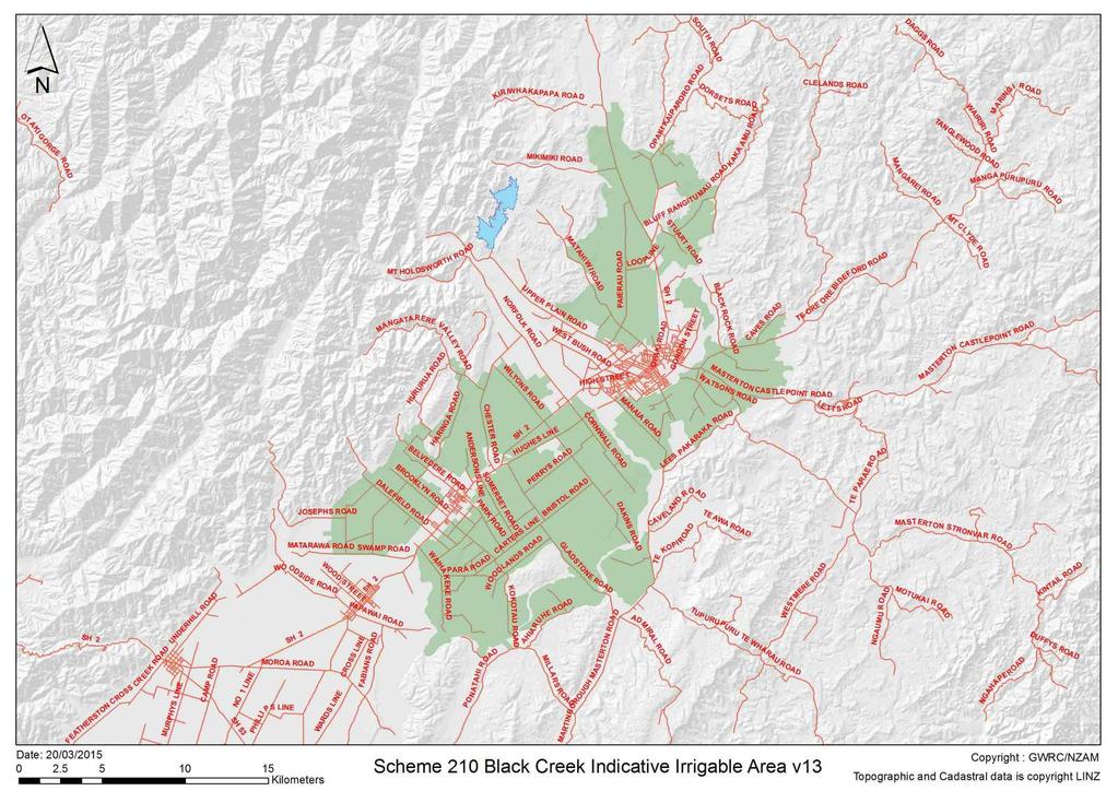
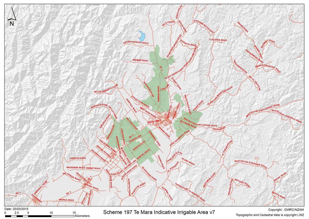
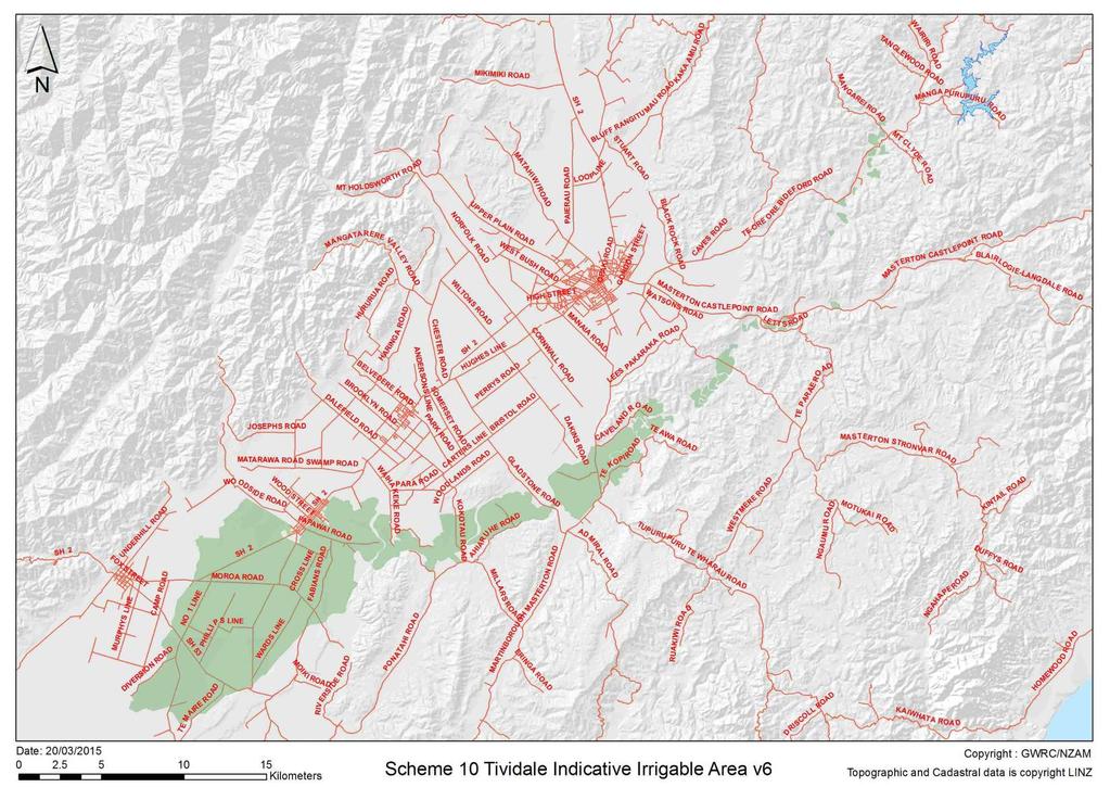
10 Archaeological site information within the five preferred scheme areas: Site No. Name River Cultural Value (noted in CVA) Recorded archaeological / historic sites Road closest Comment MCA Score (1= Least favourable, 5= Most favourable) 10 Tividale Tauweru River & Mangapurupuru Stream yes - Tauweru no Tauweru River & Mangapurupuru Stream - waka transportation and mahinga kai trails White Rock Rd confluence of Makara/ Mangapari yes - Huangarua 197 Te Mara Te Mara Stm Ruamahanga River - yes. Very significant S27/43 Pit/Terrace NZTM Pa Raupeka S25 (NZMG 1949) Keith Cairns Pa Hautotaranui S25 (NZMG 1949) Keith Cairns Occupation T26 (NZMG 1949) north at Hautotara on White Rock Rd. Location of historic European farming and Maori archaeological site. Nga waka a Kupe to the west. Kiriwhakapapa Rd The Ruamahunga River system was a key transportation highway for Maori. The number 1 of strategic pa and occupation sites attest to this significance. Tributaries such as the Te Mara Stream would have been used for travel SH2 by waka and gathering /hunting- mahinga kai 1 and access to the highly significant Ruamahunga. The stream valleys in this area often lead to trails over the Tararua Range by which iwi accessed the west coast. And west coast iwi SH2 would access inland Wairarapa. Maori trails 1 across the Tararua ranges between the Wairarapa and the west coast were used for food gathering, tribal movement and probably 4 10
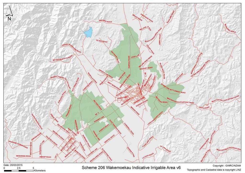
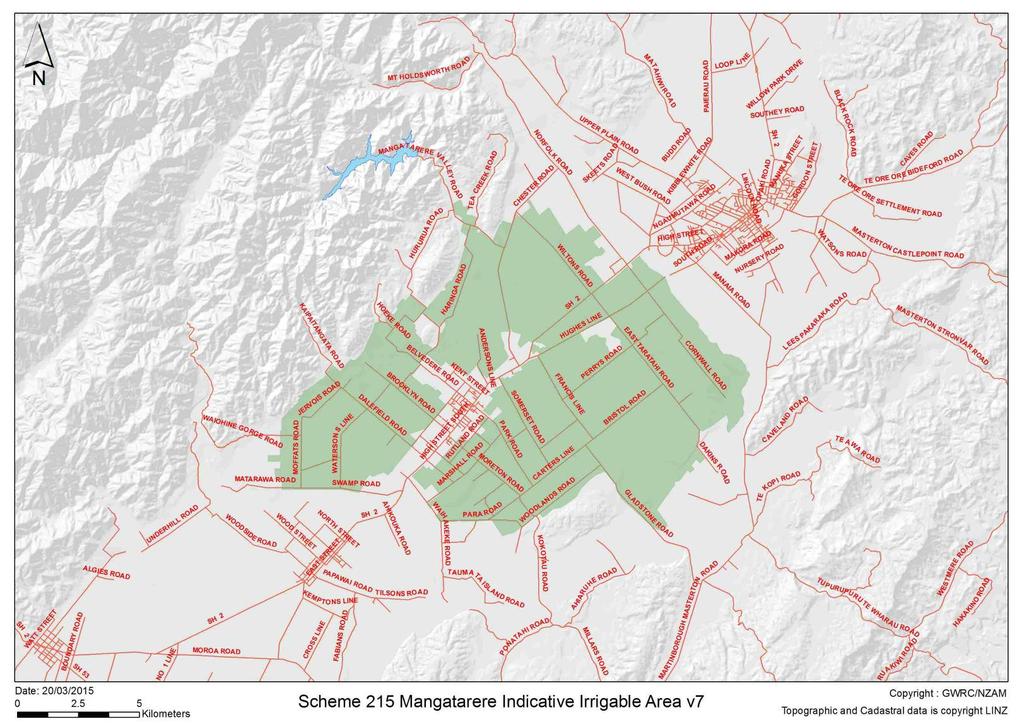
11 206 Wakamoekau (northern) 210 Black Creek (southern) Wakamoekau Ck & Black Creek Black Creek & Wakamoekau Ck 215 Mangatarere Mangatarere Stm yes - Waingawa yes - Waingawa yes, and Waiohine Pa Te Ruia Taniwha, destroyed, T26 (NZMG 1949) Keith Cairns Pa T26 Te Keakea. (NZMG 1949) Keith Cairns Pa T26 Paerau (NZMG 1949) Keith Cairns Pa T26 Te Keakea. (NZMG 1949) Keith Cairns Pa T26 Paerau (NZMG 1949) Keith Cairns S26/2 Pa Punanga NZTM also for trade. Nine routes are listed by Barton (1996) and archaeological remains were also recorded. Mikimiki Stream The known archaeological site is north of the storage area, above the Mikimiki Stream. Creeks and stream beds were used as assess ways through to the Tararua Range and foothills to the Wairarapa valley floor. Waka transportation and mahinga kai trails. SH2 Waipoua River The known archaeological site is above Waipoua River - east of the storage area. The pa is strategically located between the Ruamahunga and Waipoua rivers. Mikimiki Stream The known archaeological site is north of the storage area, above the Mikimiki Stream. Creeks and stream beds were used as assess ways through to the Tararua Range and foothills to the Wairarapa valley floor. Waka transportation and mahinga kai trails. SH2 Waipoua River Holdsworth Rd Atiwhakatu Stream The known archaeological site is above Waipoua River - east of the storage area. The pa is strategically located between the Ruamahunga and Waipoua rivers. The known archaeological site is north of the storage area on the Atiwhakatu Stream. Steam valleys were used as assess ways through to the Tararua Range and foothills to the Wairarapa
12 valley floor. Waka transportation and mahinga kai trails. 12
13 5. Legislation in New Zealand with regard to archaeological sites: There are two main pieces of legislation in New Zealand that control work affecting archaeological sites. These are the Heritage New Zealand Pouhere Taonga Act 2014 (HNZPTA) and the Resource Management Act 1991 (RMA) Heritage New Zealand administers the HNZPTA. It contains a consent (authority) process for any work affecting archaeological sites, where an archaeological site is defined as: Any place in New Zealand, including any building or structure (or part of a building or structure), that - a. Was associated with human activity that occurred before 1900 or is the site of the wreck of any vessel where the wreck occurred before 1900; and b. Provides or may provide, through investigation by archaeological methods, evidence relating to the history of New Zealand; and c. Includes a site for which a declaration is made under section 43(1) Any person who intends carrying out work that may modify or destroy an archaeological site, must first obtain an authority from Heritage New Zealand. The process applies to sites on land of all tenure including public, private and designated land. The HNZPTA contains penalties for unauthorised site damage or destruction. The archaeological authority process applies to all archaeological sites, regardless of whether: The site is recorded in the NZ Archaeological Association Site Recording Scheme or included in the Heritage New Zealand List, The site only becomes known about as a result of ground disturbance, and/ or The activity is permitted under a district or regional plan, or a resource or building consent has been granted Heritage New Zealand also maintains the New Zealand Heritage List/ Rarangi Korero of Historic Places, Historic Areas, Wahi Tupuna, Wahi Tapu and Wahi Tapu Areas. The List can include archaeological sites. Its purpose is to inform members of the public about such places. 13
14 14
15 15
16 16
17 17
18 18
19 19
Island Bay Foreshore: Archaeological Issues
 Island Bay Foreshore: Archaeological Issues arczoo Ltd, PO Box 14 575, WELLINGTON ph 04 388 5338 email aczoo@paradise.net.nz Prepared for Wellington City Council February 2005 1 Introduction Wellington
Park-specific management and policies Wainuiomata Recreation Area
 Park-specific management and policies Wainuiomata Recreation Area 6.8 Wainuiomata Recreation Area 6.8.1 Legal status Title held: Legislative status: Wellington Regional Council Administered under Local
Insert 3: Upper Hutt. Insert 2: Masterton
 Legend: -4 Injury Crash Sites 5 >5 Injury Crash Sites Napier Castle Wind Farm Hill Site Palmerston North SH50A Hastings SH SH Insert Masterton Insert 3 Havelock North SH Wellington Insert 1: Napier City
Report on proposal for: Lammerlaw Creek
 Report on proposal for: Lammerlaw Creek [altered from Lammerlaw Stream (recorded name)] MAP1 Source: New Zealand Gazetteer NZ Topo50-CE15 Crown Copyright Reserved NZ Topo50-CD14 Crown Copyright Reserved
Concessions and Permits
 Concessions and Permits ot og ers op e rato rs speci roups ri d ers tg se re s ur ph a r ph h ts to st u d e n es church or ike clubs film b m n orie a ai nt ee te n i al event orga ools n i s er sch s
No feature listed in the Schedule of Heritage Features (A8.1) may be altered, modified, (unless provided for as a minor work), removed or destroyed.
 may be altered, modified, (unless provided for as a minor work), removed or destroyed.") Section A8 Heritage A8.1 Permitted activities Unless specified as a non-complying activity, any activity affecting a feature listed in Schedule A8.1 or Schedule A8.2 that complies with the conditions within
Section A8 Heritage A8.1 Permitted activities Unless specified as a non-complying activity, any activity affecting a feature listed in Schedule A8.1 or Schedule A8.2 that complies with the conditions within
Cultural Resource Management Report Deer Valley 4wd Restoration and Blue Lakes Road Maintenance Project R
 Cultural Resource Management Report R2015-05-03-10005 Undertaking Description: The proposes to perform road maintenance and meadow restoration on the Deer Valley 4wd trail and road maintenance on the Blue
UPDATE ON MĀTAITAI RESERVE APPLICATIONS AND TAIĀPURE-LOCAL FISHERY PROPOSALS
 UPDATE ON MĀTAITAI RESERVE APPLICATIONS AND TAIĀPURE-LOCAL FISHERY PROPOSALS July 2007 Mātaitai reserve applications Aotea Harbour (west coast of the North Island) 1 On 31 August 2006 the Ministry received
Hawke s Bay Regional Parks Network. Pekapeka Regional Park Individual Park Plan
 Hawke s Bay Regional Parks Network Pekapeka Regional Park Individual Park Plan 2015-2024 Hawke s Bay Regional Council 159 Dalton Street Private Bag 6006 Napier 4110 Hawke s Bay New Zealand Telephone: 0800
50MAX Book of Maps. North Island Wellington Region. November of 20
 50MAX Book of Maps Wellington Region November 2018 1 of 20 50MAX Book of Maps Version: November 2018 6 BSN: 305 Legend 6 State Highway 50MAX Restrictions 6 BSN: 107 6 BSN: 458 6 BSN: 225 For detailed information
Hamilton City River Plan. Desk-top Archaeological Assessment Prepared for Hamilton City Council
 Hamilton City River Plan Desk-top Archaeological Assessment Prepared for Hamilton City Council Hamilton City River Plan Desk-top Archaeological Assessment Prepared for Hamilton City Council Prepared By
The Great New Zealand River Ride
 The Great New Zealand Overview River Ride The concept of the national cycleway was proposed at the Employment Summit in February 2009 by the newly elected National government. Objectives for the Cycleway
1745 Dipton- Winton Highway, Centre Bush 324 State Highway 99, Waiau River, Clifden 24 Beaufort Street, Centre Bush. 431 Selbie Road, Five Rivers
 Table 4 Section 5. - Historic Heritage Items H 55 Railway Goods Shed H 49 Clifden Suspension Bridge H3 555 St Alban's Anglican Church (Former) H4 547 Five Rivers Station Complex (Cottage,, Stables, Woolshed)
Potential additions to Aoraki/Mount Cook National Park and the World Heritage Area
 Topic Paper: Potential additions to Aoraki/Mount Cook National Park and the World Heritage Area. Purpose This paper provides the relevant background and matters for consideration regarding potential additions
.etres. E:176:28:371. Pa Site defensive (May be area E:176:28:625 Maraekaraka or Herekaki) 54
 54") Site 10 Location GPS Coordinates Description Newdicks Land - Opposite S:37:44:? Unnatural land area honesty box 20 metres in E:176:28:? paddock area. Not GPS'ed. Doesn't look right not natural could either
Site 10 Location GPS Coordinates Description Newdicks Land - Opposite S:37:44:? Unnatural land area honesty box 20 metres in E:176:28:? paddock area. Not GPS'ed. Doesn't look right not natural could either
Araiteuru Recreation Reserve
 Araiteuru Recreation Reserve Historic Heritage Assessment Kauri Coast Area Office Melina Goddard 2010 Araiteuru: Historic Heritage Assessment Melina Goddard, DoC, Kauri Coast Area Office 2010 Cover image:
Level 1 Geography, 2017
 1 91010R Level 1 Geography, 2017 91010 Apply concepts and basic geographic skills to demonstrate understanding of a given environment 9.30 a.m. Thursday 23 November 2017 Credits: Four RESOURCE BOOKLET
HVTC Winter Trip Schedule April 2018 September 2017
 HVTC Winter Trip Schedule April 2018 September 2017 APRIL RIDE Paekakariki Pekapeka Ray Hyndman 567-2772 14-15 APR Tararua Forest Park : Holdsworth T1 Atiwhakatu Hut Irene Davies 0210 566 442 D1 Sun Cannon
Masterton Tramping Club Inc. Winter Trip Schedule 2017
 Brief Trip Schedule July 2 Manawatu Gorge Ben Parsons 5 Club Night Photo Competition 8-9 Mangatainoka Hot Springs Jason Christensen 14-16 Lake Angelus Julie Millar 23 Blue Range Hut Nigel Boniface 29-30
TE WHANGANUI A OROTU. Summary of recorded Archaeological Information
 -\I TE WHANGANUI A OROTU I- Summary of recorded Archaeological Information A Report To The Waitangi Tribunal, 1'- \. \ ; ~i P Bain Department of Conservation Napier October 1992 LIST OF FIGURES Fig 1 Fig
4. Omokoroa Structure Plan
 4. Omokoroa Structure Plan 4.1 Infrastructure Schedule Project Funding Source() Developer Council Council Other Financial Contributions Rates Water Supply 72.6 27.4 Wastewater Reticulation 73.0 11.0 16.0
EXTRAORDINARY COUNCIL MEETING
 EXTRAORDINARY COUNCIL MEETING SECOND SUPPLEMENTARY AGENDA Meeting to be held in the Council Chambers, Civic Centre, Commerce Street, Whakatāne Commencing at 1:00 pm Marty Grenfell CHIEF EXECUTIVE 298 August
MAORI AFFAIRS SELECT COMMITTEE
 TUWHARETOA MAORI TRUST BOARD MAORI AFFAIRS SELECT COMMITTEE Ngati Tuwharetoa, Raukawa, and Te Arawa River Iwi Waikato River Bill Submission From: TUWHARETOA MAORI TRUST BOARD Contact Address: P.O. Box
50MAX Book of Maps. North Island Hawkes Bay Region. March of 15
 50MAX Book of Maps Hawkes Bay Region March 2018 1 of 15 50MAX Book of Maps Version: April 2018 6 BSN: 305 Legend 6 State Highway 50MAX Restrictions 6 BSN: 107 6 BSN: 458 For detailed information visit
Rangikapiti Pa Historic Reserve
 Rangikapiti Pa Historic Reserve Historic Heritage Assessment Kaitaia Area Office Melina Goddard 2011 5 Rangikapiti Pa: Historic Heritage Assessment Melina Goddard, DoC, Kaitaia Area Office 2011 Cover image:
Public offices subject to the Public Records Act October 2017
 Public offices subject to the Public Records Act 2005 - October 2017 Name of organisation Type of organisation Accreditation Council Arts Council of New Zealand Toi Aotearoa Broadcasting Commission Families
Chapter 9: National Parks and Protected Areas
 Part 9.1 Torngat Mountains National Park Reserve 9.1.1 The area set out in the Map Atlas (shown for illustrative purposes only in schedule 9-A) and described in appendix D-2 shall become a National Park
Extension of Westchester Drive, Glenside, Wellington: Archaeological assessment of proposed road extension
 Extension of Westchester Drive, Glenside, Wellington: Archaeological assessment of proposed road extension Report to Stephen Harte, Wellington City Council Mary O Keeffe Heritage Solutions 56 View Rd Melrose,
9.2.1 Organised groups and settlement during the main period of prehistoric Maori occupation
 Figure 5. Distribution of pa and pit sites in the Bay of Plenty region. 9.2.1 Organised groups and settlement during the main period of prehistoric Maori occupation The broad pattern of Maori occupation
Commuting patterns in Wellington
 Commuting patterns in Wellington Highlights In 2006, 1 of 10 employed people in New Zealand worked in one of the four cities of the Wellington region (Porirua, Upper Hutt, Lower Hutt, and Wellington),
Report to the Minister for Arts, Culture and Heritage Te Papa s performance July - December 2015
 Report to the Minister for Arts, Culture and Heritage Te Papa s performance July - December 2015 Summary 1. The purpose of this report is to provide a summary of Te Papa s six monthly progress against
Frequently Asked Questions South Head Paper Roads By the South Head Action Group
 Frequently Asked Questions South Head Paper Roads By the South Head Action Group May 2010 What is the issue about? The Rodney District Council is planning to close a safe public vehicle accessway to the
Consolidated Terms of Reference for Inquiry into the use of external security consultants 29 October 2018
 Consolidated Terms of Reference for Inquiry into the use of external security consultants 29 October 2018 This document consolidates the Terms of Reference previously issued on 27 March 2018 and 19 June
50MAX Book of Maps. North Island Hawkes Bay Region. March of 14
 50MAX Book of Maps Hawkes Bay Region March 2019 1 of 14 50MAX Book of Maps Version: March 2019 6 BSN: 305 Legend 6 State Highway 50MAX Restrictions 6 BSN: 458 6 BSN: 225 For detailed information visit
Appendix C: Consultant Report Heritage Landscapes
 Appendix C: Consultant Report Heritage Landscapes Queenstown Lakes District Council Heritage Landscapes Appraisals (based upon a desk-top appraisal of published information; September 2014) QLDC DP Ref:
PROUDLY BRINGING YOU CANADA AT ITS BEST. Management Planning Program NEWSLETTER #1 OCTOBER, 2000
 PROUDLY BRINGING YOU CANADA AT ITS BEST VUNTUT NATIONAL PARK Management Planning Program NEWSLETTER #1 OCTOBER, 2000 INTRODUCTION This newsletter launches the development of the first management plan for
St. Joe Travel Management EA CULTURAL RESOURCES
 St. Joe Travel Management EA CULTURAL RESOURCES Bruce Gibson May 2015 Regulatory Framework Forest Plan The Idaho Panhandle National Forests (IPNF) Forest Plan requires systematic cultural resource inventory
Mahinepua Peninsula. Historic Heritage Assessment Bay of Islands Area Office. Melina Goddard 2011
 Mahinepua Peninsula Historic Heritage Assessment Bay of Islands Area Office Melina Goddard 2011 Mahinepua Peninsula: Historic Heritage Assessment Melina Goddard, DoC, Bay of Islands Area Office 2011 Cover
Briefing to the Incoming Minister 2017 MUSEUM OF NEW ZEALAND TE PAPA TONGAREWA BRIEFING TO THE INCOMING MINISTER OCTOBER 2017
 MUSEUM OF NEW ZEALAND TE PAPA TONGAREWA BRIEFING TO THE INCOMING MINISTER OCTOBER 2017 1 Dear Prime Minister Congratulations on your appointment as the Minister for Arts, Culture and Heritage. A tour of
1: Use of amenities. Use of amenities by all residents in the region
 1: Use of amenities This chapter examines recent use of amenities. For those amenities that are available for most of the year (including venues and attractions such as Te Papa or Kapiti Island) the time-scale
Hauraki Maori Trust Board STRATEGIC PLAN
 Hauraki Maori Trust Board STRATEGIC PLAN FOR THE CUSTOMARY FISHERIES OF HAURAKI 2002-2052 1 This strategic planning document was developed for and approved by the Hauraki Maori Trust Board on 12 February
DIRECTOR S ORDER #41: Wilderness Preservation and Management
 These are relevant sections about Wilderness Management Plans from National Park Service 2006 Management Policies, Director s Orders #41 and Reference Manual 41. National Park Service U.S. Department of
Greater Wellington Regional Council Parks Network Plan Parangarahu Lakes Area - East Harbour Regional Park Amendment
 Greater Wellington Regional Council Parks Network Plan Parangarahu Lakes Area - East Harbour Regional Park Amendment 6.4 East Harbour Regional Park East Harbour Regional Park is located on the eastern
HEAD OF ECONOMIC PROMOTION AND PLANNING Nathan Spilsted, Senior Planning Officer Tel:
 7. TRAVELLER SITES ALLOCATIONS DOCUMENT REPORT OF: Contact Officer: Wards Affected: Key Decision: Report to: HEAD OF ECONOMIC PROMOTION AND PLANNING Nathan Spilsted, Senior Planning Officer Email: nathan.spilsted@midsussex.gov.uk
COUNCIL 27 MARCH 2014 REF:COU Item: 13. Riverside Road, Zoological Gardens Reserve Naming
 COUNCIL 27 MARCH 2014 REF:COU140313 Item: 13. Riverside Road, Zoological Gardens Reserve Naming Purpose Decision Making 1 To consider naming the Council Reserve at the end of Riverside Road in Frankton
GISBORNE DISTRICT COUNCIL BUSINESS CASE PROPOSAL. Eastland Port Access. Pedestrian Safety Rakaiatane Rd. Page 1 of 4
 GISBORNE DISTRICT COUNCIL BUSINESS CASE PROPOSAL Eastland Port Access Pedestrian Safety Rakaiatane Rd Page 1 of 4 Introduction This proposal has been developed by Gisborne District Council (GDC) to provide
Back Country Real Estate. Central Otago. Back Country
 Back Country Real Estate Central Otago Back Country 6-12 February 2017 Itinerary Join us on a new adventure as we discover the magnificent back country of the Central Otago region. We do however stress
RESULTS, CONTINUED. Figure 47. Unusual platforms and quarry face, looking northwest. Figure 48. Unusual platforms and quarry face, looking west
 RESULTS, CONTINUED Figure 47. Unusual platforms and quarry face, looking northwest Figure 48. Unusual platforms and quarry face, looking west Clough & Associates Ltd. Page 52 7-37 Ngataringa Road, Devonport
Archaeological Investigations Project Yorkshire & Humberside Region NORTH YORKSHIRE 2/1113 (C.36.J002) SD
 SD") NORTH YORKSHIRE Craven 2/1113 (C.36.J002) SD 93607800 CRAY BECK, BUCKDEN, UPPER WHARFEDALE Cray Beck, The Archaeological Investigation of a Stone Feature Archetype Wensleydale : ArcheType Archaeological
NORTH YORKSHIRE Craven 2/1113 (C.36.J002) SD 93607800 CRAY BECK, BUCKDEN, UPPER WHARFEDALE Cray Beck, The Archaeological Investigation of a Stone Feature Archetype Wensleydale : ArcheType Archaeological
Nohoanga Management Plan
 Nohoanga Management Plan 15 October 2015 Prepared by Te Rūnanga o Ngāi Tahu Page 1 of 30 RĀRANGI UPOKO / TABLE OF CONTENTS RĀRANGI UPOKO / TABLE OF CONTENTS... 2 1. KUPU WHAKATAKI / INTRODUCTION... 5 1.1
Auranga Stage B1: archaeological assessment
 Auranga Stage B1: archaeological assessment report to Karaka and Drury Ltd Arden Cruickshank, Jacqueline Craig and Danielle Trilford CFG Heritage Ltd. P.O. Box 10 015 Dominion Road Auckland 1024 ph. (09)
National Wilderness Steering Committee
 National Wilderness Steering Committee Guidance White Paper Number 1 Issue: Cultural Resources and Wilderness Date: November 30, 2002 Introduction to the Issue Two of the purposes of the National Wilderness
Stage Travel southwards to the northern most airport at 3. Move off down the main East Coast Road to a fishing village in Doubtless Bay called
 In addition to finding the answers, you are also to map your progress on a giant map of NZ which you will you need to do either on your own or in a group. 1 2 3 4 5 6 7 8 M1 M2 M3 M4 Date Started Giant
Following the initial soil strip archaeology is sprayed up prior to planning and excavation
 Barton Quarry & Archaeology Over the past half century quarries have been increasingly highlighted as important sources of information for geologists, palaeontologists and archaeologists, both through
Back Country Real Estate. Central Otago. Back Country
 Back Country Real Estate Central Otago Back Country 23-29 March 2018 Join us on a new adventure as we discover the magnificent back country of the Central Otago region. We do however stress that we are
(spelling alteration from Hodge Creek) Tributary of Leslie River, Wharerapa / Arthur Range, Kahurangi National Park
 Tributary of Leslie River, Wharerapa / Arthur Range, Kahurangi National Park") Report for Altered Names: Hodges Creek (NZGB suggests Stream) (spelling alteration from ) Tributary of Leslie River, Wharerapa / Arthur Range, Kahurangi National Park Hodges Creek (spelling alteration
Report for Altered Names: Hodges Creek (NZGB suggests Stream) (spelling alteration from ) Tributary of Leslie River, Wharerapa / Arthur Range, Kahurangi National Park Hodges Creek (spelling alteration
1 INFORMATION REQUIREMENTS
 1 INFORMATION REQUIREMENTS 1.1 BACKGROUND 2 1.2 WHAT IS THE DISTRICT PLAN 3 1.3 DISTRICT PLAN STRUCTURE 4 1.4 HOW TO USE THE DISTRICT PLAN 5 1.5 STRATEGIC FRAMEWORK 6 Whanganui District Plan (15 January
In the matter of The Resource Management Act And The Queenstown Lakes District proposed District Plan Topic 11 Ski Area Subzones mapping
 Before Queenstown Lakes District Council In the matter of The Resource Management Act 1991 And The Queenstown Lakes District proposed District Plan Topic 11 Ski Area Subzones mapping STATEMENT OF EVIDENCE
JANDAKOT AIRPORT HERITAGE MANAGEMENT PLAN
 JANDAKOT AIRPORT HERITAGE MANAGEMENT PLAN CONSERVATION MANAGEMENT PLAN APPENDIX I Jandakot Airport Holdings Pty Ltd 16 Eagle Drive Jandakot WA 6164 Ref: CMP Appendix I Heritage Management Plan 2014 V1.Docx
The Collection and Use of Safety Information
 Page 1 of 1 1. Purpose and Scope... 2 2. Authority... 2 3. References... 2 4. Records... 2 5. Policy... 2 5.1 Context... 2 5.2 Issues Relevant to this Policy... 3 5.3 Civil Aviation Rules and Advisory
Demographic Profile 2013 census
 Demographic Profile 2013 census This profile provides basic population and demographic information on the residents of the Hauraki District. Population and demographic information is important for targeting
4180 acre-feet minimum conservation pool
 MEMORANDUM Subject: Bear River Basin Plan SULPHUR CREEK RESERVOIR Date: July 20, 2000 Location: Section 34, Township 14N, Range 119W. Located on Sulphur Creek, tributary to the Bear River. Located approximately
MANAGEMENT DIRECTION STATEMENT June, 1999
 Thompson River District MANAGEMENT DIRECTION STATEMENT June, 1999 for Roche Lake Provincial Park Ministry of Environment Lands and Parks BC Parks Division Table of Contents I. Introduction A. Setting
A stronger voice for Māori in natural resource governance and management
 A stronger voice for Māori in natural resource governance and management Paul Beverley Resource Management and Māori Law Team, Buddle Findlay - paul.beverley@buddlefindlay.com Wednesday 15th April 1.30-3.15pm
Part 149. Aviation Recreation Organisations - Certification. CAA Consolidation. 1 February 2016
 Part 149 CAA Consolidation 1 February 2016 Aviation Recreation Organisations - Certification Published by the Civil Aviation Authority of New Zealand DESCRIPTION Part 149 prescribes rules governing the
TE IKA-A-MĀUI NORTH ISLAND 2017/2018
 TE IKA-A-MĀUI NORTH ISLAND 07/08 Responsible camping You could get a $00 instant fine by: Freedom camping overnight where there is a no camping sign. Freedom camping overnight where there is a self-contained
Agreement Between the West Somerset Railway PLC and the West Somerset Steam Railway Trust Ltd
 Agreement Between the West Somerset Railway PLC and the West Somerset Steam Railway Trust Ltd This Agreement between the West Somerset Steam Railway Trust Ltd ( the Trust ) (company no. 1079916, registered
RESEARCH BULLETIN. Parks Canada. Parcs Canada. Cette publication est disponible en français.
 RESEARCH BULLETIN No. 201 August 1983 Scratching the Surface-Three Years of Archaeological Investigation in Wood Buffalo National Park, Alberta/N.W.T.-Preliminary Summary Report Marc G. Stevenson Archaeology,
Decision Required. c) Brief Council on the proposed dual name for Benneydale for consideration.
 Brief Council on the proposed dual name for Benneydale for consideration.") Document No: A413344 Report To: Council Meeting Date: 27 November 2018 Subject: Type: Office of Treaty Settlements Proposed Cultural Redress: Statutory Acknowledgments and Proposal for a Dual Name for
Document No: A413344 Report To: Council Meeting Date: 27 November 2018 Subject: Type: Office of Treaty Settlements Proposed Cultural Redress: Statutory Acknowledgments and Proposal for a Dual Name for
PROPOSED COMMUNITY MARINE ACTIVITY HUB, TAKAPUNA, AUCKLAND: ARCHAEOLOGICAL ASSESSMENT
 PROPOSED COMMUNITY MARINE ACTIVITY HUB, TAKAPUNA, AUCKLAND: ARCHAEOLOGICAL ASSESSMENT Report prepared for Harbour Access Trust By Adina Brown (MA, MSc) February 2015 Clough & Associates Ltd. heritage@clough.co.nz
Boyne Valley Provincial Park. Interim Management Statement
 Boyne Valley Provincial Park Interim Management Statement January 20, 1995 REGIONAL DIRECTOR'S APPROVAL STATEMENT This Interim Management Statement will provide interim direction for the management of
Ruakituri River New Zealand Rivers Egarr, Egarr & Mackay New Zealand Recreational River Survey G & J Egarr
 Ruakituri River Key Values Cultural Recreation (angling, rafting, kayaking) Ecology (fisheries, wildlife) Landscape (scenic) Natural character Table 1: List of documents reviewed Year Name Author 1979
Wilderness Stewardship Plan Scoping Newsletter Winter 2013
 Olympic National Park National Park Service U.S. Department of the Interior Wilderness Stewardship Plan Scoping Newsletter Winter 2013 Dear Friends and Neighbors, The Olympic Wilderness was established
TOEFL ibt Quick Prep. Volume 1. Go anywhere from here.
 TOEFL ibt Quick Prep Volume 1 Go anywhere from here. INTRODUCTION Introduction ABOUT THE TOEFL ibt TEST The TOEFL ibt test measures your ability to use and understand the English language as it is read,
FACILITIES INVENTORY SURVEY REPORT
 CURRENT PUBLIC TRANSPORT REPORT FACILITIES INVENTORY SURVEY REPORT ZULULAND DISTRICT MUNICIPALITY TABLE OF CONTENTS Page No. 1.... INTRODUCTION... 3 2.... ACKNOWLEDGEMENTS... 3 3.... THE STUDY AREA IN
NEW ZEALAND REGIONAL TOURISM FORECASTS
 NEW ZEALAND REGIONAL TOURISM FORECASTS 21-216 QUEENSTOWN RTO AUGUST 21 www.tourismresearch.govt.nz Tourism Strategy Group Ministry of Economic Development Contents Introduction 1 1. Summary for Queenstown
NEW ZEALAND REGIONAL TOURISM FORECASTS
 NEW ZEALAND REGIONAL TOURISM FORECASTS 21-216 NELSON RTO AUGUST 21 www.tourismresearch.govt.nz Tourism Strategy Group Ministry of Economic Development Contents Introduction 1 1. Summary for Nelson RTO
NEW ZEALAND REGIONAL TOURISM FORECASTS
 NEW ZEALAND REGIONAL TOURISM FORECASTS 21-216 ROTORUA RTO AUGUST 21 www.tourismresearch.govt.nz Tourism Strategy Group Ministry of Economic Development Contents Introduction 1 1. Summary for Rotorua RTO
NEW ZEALAND REGIONAL TOURISM FORECASTS
 NEW ZEALAND REGIONAL TOURISM FORECASTS 21-216 LAKE TAUPO RTO AUGUST 21 www.tourismresearch.govt.nz Tourism Strategy Group Ministry of Economic Development Contents Introduction 1 1. Summary for Lake Taupo
Waewaetorea Island. Historic Heritage Assessment Bay of Islands Area Office. Melina Goddard 2012
 Waewaetorea Island Historic Heritage Assessment Bay of Islands Area Office Melina Goddard 2012 Waewaetorea Island Scenic Reserve Historic Heritage Assessment Melina Goddard, DoC, Bay of Islands Area Office
Instream intrinsic values of the Te Puna Creek catchment
 Instream intrinsic values of the Te Puna Creek catchment J. Benn Technical Support Department of Conservation Canterbury Conservancy Christchurch (25 October 2011) Draft/living document Disclaimer This
HUT POINT, ROSS ISLAND
 Measure 2 (2005) Annex K Management Plan for Antarctic Specially Protected Area No. 158 HUT POINT, ROSS ISLAND (including Historic Site and Monument No. 18, the historic Discovery hut of Captain R F Scott)
John Maihi welcomed everyone and invited Charlie Osborne to open the meeting with karakia. 1. Apologies
 Minutes of the Annual Hui of Whanganui District Council and Te Rūnanga O Tupoho held at 3.30pm on Wednesday, at Rangahaua, 97 Bell Street, Whanganui. Present: In Attendance: Apologies: John Maihi (in the
Memorandum of Understanding
 Memorandum of Understanding In Accordance with Section V of the U.S./Canada Bilateral Aviation Safety Agreement Implementation Procedures for Design Approval, Production Activities, Export Airworthiness
Central Cascades Wilderness Strategies Project
 Central Cascades Wilderness Strategies Project Wilderness is Unique What makes designated Wilderness different from other national forest lands? Wilderness Act of 1964 to assure that an increasing population
Submission on the Tukituki Catchment Proposal: EPA reference numbers; NSP 13/ , NSP 13/ , NSP 13/ , NSP 13/02.
 Hutt Valley Tramping Club PO Box 30 883 LOWER HUTT 5045 Tukituki Catchment Proposal Environmental Protection Agency Private Bag 63 002 WELLINGTON 6140 29 July 2013 Submission on the Tukituki Catchment
Regional Transport Committee OPEN MINUTES
 Regional Transport Committee OPEN MINUTES Minutes of a meeting of the Regional Transport Committee held in Council Chambers, Waikato Regional Council, 401 Grey Street, Hamilton East on 11 June 2018 at
Bayview Escarpment. Interim Management Statement
 Bayview Escarpment Interim Management Statement Bayview Escarpment Provincial Nature Reserve Interim Management Statement January 15, 1995 REGIONAL DIRECTOR'S APPROVAL STATEMENT This Interim Management
THE TANIWHA AND THE DRAGON: CHALLENGES AND OPPORTUNITIES FOR MĀORI BUSINESSES WITH CHINA
 THE TANIWHA AND THE DRAGON: CHALLENGES AND OPPORTUNITIES FOR MĀORI BUSINESSES WITH CHINA Dr Martin Fisher University of Canterbury, & Mr Ben Matthews Ngā Puhi, Tauranga Moana, Ngāti Porou martin.fisher@canterbury.ac.nz
Hutt Valley Tramping Club Summer Trip Schedule October 2018-March 2019
 Hutt Valley Tramping Club Summer Trip Schedule October 2018-March 2019 Postal address: Web site: E-mail: Clubrooms: Club nights: P.O. Box 30-883, Lower Hutt www.hvtc.org.nz info@hvtc.org.nz Philip Evans
50MAX Book of Maps. North Island Bay of Plenty Region. March of 18
 50MAX Book of Maps North Island Bay of Plenty Region March 2019 1 of 18 50MAX Book of Maps Version: March 2019 North Island North Island BSN: 305 Legend State Highway 50MAX Restrictions BSN: 458 BSN: 225
AN ARCHAEOLOGICAL ASSESSMENT OF BOERNE CITY PARK, KENDALL COUNTY, TEXAS. Thomas C. Kelly and Thomas R. Hester
 AN ARCHAEOLOGICAL ASSESSMENT OF BOERNE CITY PARK, KENDALL COUNTY, TEXAS Thomas C. Kelly and Thomas R. Hester Center for Archaeological Research The University of Texas at San Antonio Archaeological Survey
Park-specific management and policies. Akatarawa Forest
 Park-specific management and policies Akatarawa 6 Park-specific management and policies 6.1 Akatarawa 6.1.1 Legal status Title held: Legislative status: Wellington Regional Council Administered under Local
Range Creek Rock Art, The First Year
 Steven J. Manning Range Creek Rock Art, 2002. The First Year The purpose of this paper is to report the findings of an archaeological reconnaissance inventory conducted in August 2002 on the Waldo Wilcox
WORKSHEET 1 Wilderness Qualities or Attributes Evaluating the Effects of Project Activities on Wilderness Attributes
 WORKSHEET 1 Wilderness Qualities or Attributes Evaluating the Effects of Project Activities on Wilderness Attributes Date: 3/7/2017 Roadless Area: Ruby South Description of Project Activity or Impact to
New Zealand Heritage List/Rārangi Kōrero Report for a Historic Place Meretoto/Ship Cove, Tōtaranui/Queen Charlotte Sound (List No.
 New Zealand Heritage List/Rārangi Kōrero Report for a Historic Place Meretoto/Ship Cove, Tōtaranui/Queen Charlotte Sound (List No.9900 Category 1) Meretoto/Ship Cove (Kerryn Pollock, Heritage New Zealand,
LINCOLNSHIRE PARKING POLICY DRAFT
 LINCOLNSHIRE PARKING POLICY DRAFT Draft 23/05/11 1 of 7 1. Introduction This document sets out and explains the County Councils Parking Policy. The County Council is planning to apply for powers to take
NZ price index relative to peak
 Media release 7 April, 2014 Residential property value growth plateaus The latest monthly property value index shows that nationwide residential values for March have increased 8.8% over the past year,
California State University Long Beach Policy on Unmanned Aircraft Systems
 California State University, Long Beach June 14, 2016 Policy Statement: 16-04 California State University Long Beach Policy on Unmanned Aircraft Systems The following policy statement was recommended by
6. Archaeological investigation of a souterrain at Tateetra, Dundalk, County Louth Avril Hayes
 6. Archaeological investigation of a souterrain at Tateetra, Dundalk, County Louth Avril Hayes Illus. 1 Location map of Tateetra in relation to the other excavated sites along the route of the M1 Dundalk