left: Coombe Island from Wheeler
|
|
|
- Judith Washington
- 5 years ago
- Views:
Transcription


1 left: Coombe Island from Wheeler In 1770 Captain Cook named a group of islands, close to the north Queensland mainland, the Family Islands. The family consists of two larger islands, Dunk and Bedarra (Richards), a set of smaller twins, Coombe and Wheeler, and a set of small triplets, Smith, Bowden and Hudson Islands, as well as numerous islets and rocks. The islands are all continental islands of granite, but have coral reefs offshore, and coral sand beaches, which are usually most evident on the island side most sheltered from the south east trade winds, that is, on the north west side of the islands. As island National Parks, camping is permitted on Dunk, Wheeler and Coombe. There are resorts on Dunk and Bedarra, and Bedarra and Thorpe are privately owned. Images: H j Preuss below: Purtaboi (Mound) Island
2 Access to the southern end of Rockingham Bay is possible from near Lucinda, by travelling the seaward side of Hinchinbrook Island, or by taking the Hinchinbrook Channel between the island and the mainland, or by leaving from Cardwell, with a 17km paddling leg to Goold Island. With the prevailing winds blowing (quite strongly at times!) from the south east, and the falling tide ebbing to the north, it can be appropriate to plan a trip to travel south to north. Given that the Family Islands are closely grouped, and access from the mainland is very close from Mission Beach, a southern point of departure is not a prerequisite for a successful trip. This guide explores the Family Islands from northern most Dunk Island, then south to Coombe and Wheeler, and Smith, Bowden and Hudson.. A separate guide to Goold Island, soon available, should help kayakers explore the southern bay. This is called a photo guide as it is intended to assist in sight recognition of Islands, and give general background information. It is not a substitute for the correct topographic maps or marine charts. Please comply with the National Parks regulation of camping, by permits, and respect closures of certain islands to access, during bird nesting seasons.
 is 1590 km from Brisbane, 140 km south of Cairns, and 235 km north of Townsville.")


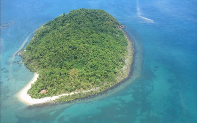
3 On the mainland opposite Dunk Island is the small town of Mission Beach, which is spread out along the shoreline. Mission Beach (consisting of South Mission Beach, Wongaling Beach, Mission Beach, and Bingil Bay) is 1590 km from Brisbane, 140 km south of Cairns, and 235 km north of Townsville. It is 20km off the Bruce Highway, a total of 22km distance from the highway town of Tully, noted for whitewater rafting on the Tully River nearby, and for the Golden Gumboot award for the highest annual rainfall in Australia. above: kayakers, early morning, Wongaling Beach left: Dunk Island seen from Mission Beach Dunk Island is 5.5 km offshore from Wongaling Beach, and 4 km from South Mission Beach, depending on which point of departure you prefer. The island is about 5.5 km long (lying roughly NW to SE) and about 1.5 km across. The last 1.5km southern part of the island narrows down, from 400m across the peninsula, to less than 200m. The Dunk Island resort is on the NW side of the island, serviced by a jetty on the long sand spit at the NW tip. A small island, Mound or Purtaboi Island, lies north west of Dunk, and is closed to access during the bird nesting season. left: Purtaboi (Mound) Island. images: Hj Preuss
4 Dunk is mostly National Park, some 730 ha of the 970ha, the remainder being resort owned land that includes an airstrip, originally cleared during WW II to service a radar installation on Mt Kootaloo, 271m. To the west of Dunk, halfway down, are two more smaller islands, Kumboola and Mung Um Gnackum, that are accessible by walkers, at very low tides, from Dunk Island. Keep that in mind if planning to paddle the west coast at low water, and aim to pass to seaward of these two. Take care where you go ashore on the south western side of the island, and look for close deepwater, to not face a long boat drag back to water on falling tides. On the subject of landing sites, take care, that when the strong south east winds are pushing up a sizeable wave, deep water close inshore can mean difficulty landing onto the steep coral beaches. There are few things more uncomfortable than capsizing at the waters edge, in a wave.


5 approaching Dunk Island from Mission Beach the rocky north east coast of Dunk Woln Garin Is, south east Dunk Island above images: H j Preuss south west coast, Dunk Island Dunk Island sees a lot of day visitors. The National Parks campground is near Pallon Beach, on the north west side of the island. A 3 hour return walk (7km) through rainforest to the top of Mt Kootaloo is easily accessible from near the resort and the campground. From the summit and the remains of the WWII radar station, it is possible to look at the line of the Family Islands stretching south down Rockingham Bay. Other walks include an island circuit track (return 4 hours, 10.8km), and a track down to Coconut Beach (return 2.5 hours, 7.6km) along the wesern side of the island. rainforest on the Mt Kootaloo trail images: G. Young WW II radar site, Mt Kootaloo


6 This view from Mt Kootaloo on Dunk Island shows Kumboola Island on the far right behind the trees, and, Thorpe Island next left, then Bedarra Island in the centre of the photograph. Wheeler Island, looking misted out, is barely visible on the left. Below is a view of Bedarra Island, right, and Wheeler Island, left, taken from just offshore near Coconut Beach on Dunk Island. Bedarra is 6 km away, the lofty peak of Goold Island, centre, is 21km distant, and Wheeler island is 7.7 km away. top image: G. Young. below image: Hj Preuss
 is visible as a low hummock to the right of Battleship Rock.")

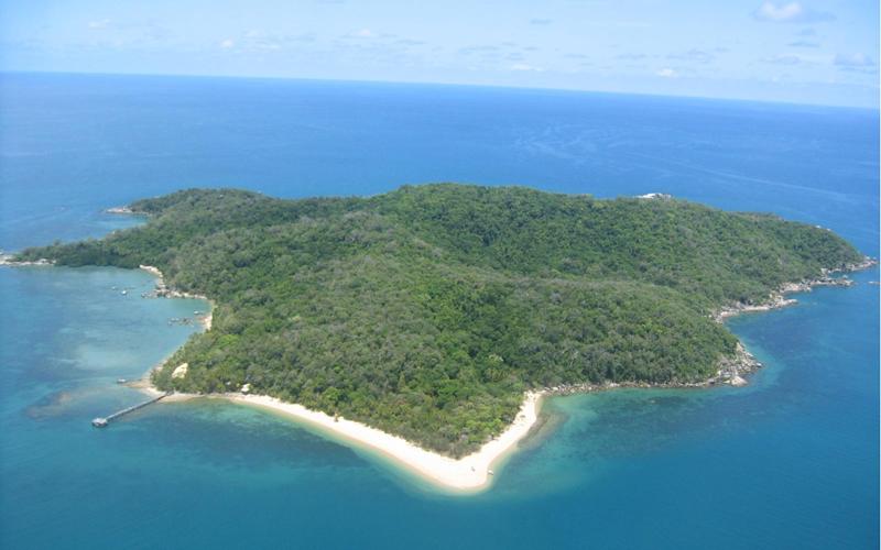
7 images: Hj Preuss Above, and below, the privately owned resort island of Bedarra (Richards) Island, which is approximately 4.8 km south of mid Dunk Island.In the above photograph, taken from Wheeler Island, Thorpe Island (Timana) is visible as a low hummock to the right of Battleship Rock. Thorpe Island, (privately owned) has a residence next to the sandy beach on the north west coast. Dunk Island fills the horizon on the right. Bedarra Island has many small coves, with a total coastline of almost 6 km.. The photograph below shows rocky Pee-Rahm-Ah Island, known also as Battleship Rock, for its distinctive shape, to the right of Bedarra. Photograph taken by sea kayakers on route from Wheeler Island to Dunk Island, approaching Bedarra. Bedarra resort is not a large establishment, nor family resort, consisting of 14 private villas, beside the white sandy beaches on the western, or mainland, side of the island.. The island (north south 1.5 km x 1.0 km east west) has a rainforest covering.


8 above: campsite on Wheeler Island, with Goold Island to the south west. below: Coombe Island from campsite on Wheeler. Images: H j Preuss

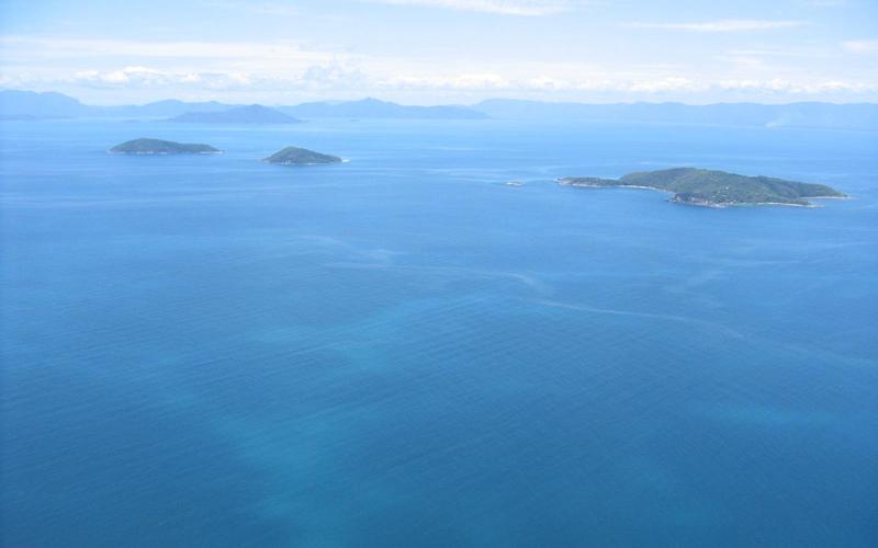
9 above: left to right are the triplets of Smith, Bowden, and Hudson Islands (Kurrumbah, Budjoo and Coolah) seen from the granite foreshore of Coombe Island. above image: G. Young below: Smith Island and Bowden Island seen from Wheeler Island above image: C. Thompson


10 campsite on Coombe Island images: G. Young


11 images: J. Gibson Kayakers paddling north from Goold Island towards Coombe and Wheeler Islands took this photograph of. Smith, Bowden, and Hudson Islands off to starboard. Smith and Bowden Islands overlap on the left, with Hudson on the right. Below, Bedarra Island left, then Wheeler and Coombe Islands on the right. This view taken a little further north from the perspective in the photograph above, by kayakers paddling north from Goold Island towards Coombe and Wheeler Islands.


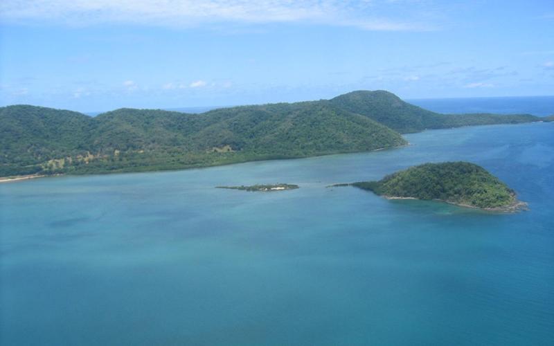
12 above: Wheeler Island campsite Image: C. Thompson left: Hudson Island Image: G. Young left: Hudson Island Image: G. Young. Wheeler Island top left, Coombe Island middle left, and right, Smith, Bowden (obscured) and Hudson Islands. The aerial images on the following three pages are copyright to, and courtesy of, Deliwala, Bhupendra H. (KSC)
13
14
15
Unit 1 Lesson 1: Introduction to the Dry Tortugas and Sustainable Seas Expedition
 Unit 1 Lesson 1: Introduction to the Dry Tortugas and Sustainable Seas Expedition Lesson Objectives: Introduce students to the historical, geographic, and ecological importance of the Dry Tortugas. Introduce
Great Barrier Reef Fact Sheet
 Great Barrier Reef Fact Sheet Discover the only living thing you can see from space. Imagine what it s like face to face. Explore the Great Barrier Reef s exclusive islands and remote reefs aboard MV Coral
middle left: Riversleigh fossils lower left: Constance Range images: Hj Preuss... Thx
 Upstreampaddle Summer 2008 18 middle left: Riversleigh fossils lower left: Constance Range images: Hj Preuss... Thx top right: road west of the Isa middle right: Constance Range lower right: rocky outcrop
70 GREAT WALKS OCTOBER_NOVEMBER
 70 GREAT WALKS OCTOBER_NOVEMBER 2017 WWW.GREATWALKS.COM.AU 71 GREAT TROPICAL WALKS HINCHINBROOK ISLAND, QLD ISLAND LIFE The Thorsborne Trail on Hinchinbrook Island is one of Queensland s greatest tropical
The Entrance to Phillips Arm Cardero Channel
 The Entrance to Phillips Arm Cardero Channel Jason Zroback jason@landquest.com 1 (604) 414-5577 Jamie Zroback jamie@landquest.com 1 (604) 483-1605 The Source for Oceanfront, Lakefront, Islands, Ranches,
Beagle Yacht Itinerary 8 Days A
 Beagle Yacht Day Activities 1 Charles Darwin Station: After an early arrival to the airport in Baltra you will be transferred to Beagle Yacht at the Bay. After lunch, we head to the Charles Darwin Station,
10.7 Acre Oceanfront North Rendezvous Island
 10.7 Acre Oceanfront North Rendezvous Island Jamie Zroback jamie@landquest.com 1 (604) 483-1605 Jason Zroback jason@landquest.com 1 (604) 414-5577 The Source for Oceanfront, Lakefront, Islands, Ranches,
10 Day Tropical Adventure
 10 Day Tropical Adventure First stop, the fun and games of Cairns. Next, get a true taste of the outback on an Aussie farm before switching down a gear as you sail The Whitsundays. This trip will give
swahili coast safari
 Fundu Lagoon DAY BY DAY ITINERARY swahili coast safari 888.658.7102 info@deeperafrica.com www.deeperafrica.com OVERVIEW: FUNDU LAGOON - PEMBA ISLAND Fundu Lagoon offers five star luxury, plus your own
Illawarra Escarpment State Conservation Area Walking Tracks
 Illawarra Escarpment State Conservation Area Walking Tracks NPWS Illawarra Area Office Ground Floor, Government Office Block 84 Crown Street Wollongong NSW 2500 02 4223 3000 (Mon-Fri) Royal National Park
Lizard Island Research Station Tour 9-14 October, 2015
 Lizard Island Research Station Tour 9-14 October, 2015 The Australian Museum Tour to Lizard Island Back by popular demand, the Australian Museum is pleased to offer an unforgettable expedition to the Australian
Route planner Kvarner bay, Istria
 Route planner Kvarner bay, Istria base Veruda/Pula route 4 (1 week) Novigrad Opatija Porec Rovinj KRK Cres Punat NP Brijunj Veruda Medulin Pomer CRES RAB Osor UNJE LOSINJ Mali Losinj ILOVIK SILBA day:
Redesigning The Waterfront
 San Francisco Maritime National Park Service U.S. Department of the Interior National Historical Park California Redesigning The Waterfront A Self-Guided Walking Tour Then & Black Point Cove, ca. 1910.
Green Point Cabin Cordero Channel
 Green Point Cabin Cordero Channel Jason Zroback jason@landquest.com 1 (604) 414-5577 Jamie Zroback jamie@landquest.com 1 (604) 483-1605 Marketing British Columbia to the World The Source for Oceanfront,
Isle Royale Info Section 5: Campgrounds
 Isle Royale Info Section 5: Campgrounds Overview: All of the campgrounds are very well marked and the sites have shelters and or tent pads. Shelters are typically available at campgrounds on Lake Superior,
Introduction to Map 30: Sgeir Alt Mhic Eoghainn to Ton Loisgte
 Introduction to : Sgeir Alt Mhic Eoghainn to Ton Loisgte This map section covers some 7.8km of coastline. This section takes in the south western facing butt of the Rhinns and includes the villages of
3, 4 & 7 NIGHT EXPEDITION CRUISES. Great Barrier Reef A PERSONAL JOURNEY THROUGH NATURE S GREATEST MARINE WONDERLAND
 3, 4 & 7 NIGHT EXPEDITION CRUISES Great Barrier Reef A PERSONAL JOURNEY THROUGH NATURE S GREATEST MARINE WONDERLAND " we travel not to escape life but for life to escape us anon coralexpeditions Coral
PLUMPER COVE MARINE PARK MASTER PLAN
 Lower Mainland Region Park Operations Branch Parks and Outdoor Recreation Division Ministry of Lands, Parks and Housing North Vancouver, B.C. PLUMPER COVE MARINE PARK MASTER PLAN DECEMBER, 1980 PLUMPER
Wicklow Mountains Path Survey
 Wicklow Mountains Path Survey Ballinacor Croaghanmoira Fananierin Start to Finish: T 11723 86602 to T 11175 89057 Altitude (lowest highest): 385m 664m Weather: Hot Access: Coolgarrow forest entrance Surveyed
Cruising itinerary. Vlassof Cay, Great Barrier Reef
 Cruising itinerary Set proudly in the Sunshine State of Queensland, cultured Cairns is the gateway to many of Australia s famous UNESCO sites, including the Great Barrier Reef, the Whitsunday Islands,
GALAPAGOS MULTISPORT ADVENTURE TOUR
 GALAPAGOS MULTISPORT ADVENTURE TOUR 7 DAYS / 6 NIGHTS Spend a week exploring the Galapagos Islands! Kayak the pristine waters alongside sea turtles, hammerhead sharks and sea lions. Hike up active volcanoes
Contemporary Coastal Living EXCLUSIVE HOMESITES
 Contemporary Coastal Living EXCLUSIVE HOMESITES Peace of mind in Paradise Your investment in Oceans Edge makes sound financial sense, now and into the future. The unique planning regulations that shape
14 Day Cairns to Sydney Tour Package with Loka and Real Aussie Adventures
 14 Day Cairns to Sydney Tour Package with Loka and Real Aussie Adventures Please note: all the MEET times listed below are departure times, please be waiting at the designated location 10 minutes prior.
Access: The rocky shoreline is only accessible via private property.
 10. Whale Cove Site description: Whale Cove is a small cove fringed by private homes and condominiums with diverse and relatively undisturbed rocky intertidal and subtidal habitat located approximately
ISLAND. FOR SALE Spanish Lookout Caye -186 Acre Island
 FOR SALE Spanish Lookout Caye -186 Acre Island ISLAND 186 Acre Private Island - Spanish Lookout Caye - just off Cruise Ship Mooring 8.5 Miles Southeast of Belize City, Spanish Lookout Caye Belize Spanish
VARGAS ISLAND PROVINCIAL PARK
 VARGAS ISLAND PROVINCIAL PARK PURPOSE STATEMENT AND ZONING PLAN February 2003 VARGAS ISLAND PROVINCIAL PARK Purpose Statement and Zoning Plan Primary Role The primary role of Vargas Island Park is to protect
Ranging Sales Agent Veronica Rosero Passengers Travel dates September 08-12, 2017 Date of Issue Tuesday, 04 July, 2017
 Program name PRE-CRUISE TMLA Ref. No. No. of Ranging Sales Agent Veronica Rosero Passengers Travel dates September 08-12, 2017 Date of Issue Tuesday, 04 July, 2017 ITINERARY DESCRIPTION Ecuador A natural
Mayor Julia Leu Douglas Shire Council
 Mayor Julia Leu 2018 Where the rainforest meets the reef Douglas Shire is known for its spectacular rainforest covered ranges, beautiful beaches, agriculture, Indigenous culture and a diversity of vibrant
10 day Tropical Adventure ex. Brisbane
 10 day Tropical Adventure ex. Brisbane One hot and sultry trip of Australia dedicated entirely to the charms of the East Coast in tropical Queensland. Travel between the modern metropolis of Brisbane and
Proposal for Thai IX 2010 Peace Corps Reunion
 Proposal for Thai IX 2010 Peace Corps Reunion Introduction We propose that we meet in September or early October, 2010, in Acadia National Park on Mt. Desert, Maine. The park is a magnificent setting,
ITINERARY DAYS/5NIGHTS
 ITINERARY 2016 6 DAYS/5NIGHTS Tuesday to Sunday (every 15 days) Day 1 Tuesday Cerro Colorado, San Cristóbal Upon arrival at San Cristobal Airport, travelers pass through an airport inspection point to
MAGNETIC ISLAND YHA YHAGROUPS.COM.AU
 B U D G E T G R O U P A C C O M M O D AT I O N 2 0 1 7 Set in the heart of untouched National Park and a short walk to Horseshoe Bay, Magnetic Island YHA provides great value for all of your group accommodation
4 Days 3 Nights Koh Lipe Package(Ex-Langkawi)** MIN 8 PERSON TO GO
** MIN 8 PERSON TO GO") 4 Days 3 Nights Koh Lipe Package(Ex-Langkawi)** MIN 8 PERSON TO GO 1 St Day Langkawi KohLipe 08.00a.m or 13.00pm (Malay Time) Check in the Ferry ticket @ Kouh Jetty 09.30 a.m(01-15 Nov 15 &20 Apr-19 May
4 Days 3 Nights Koh Lipe Package(Ex-Langkawi)** MIN 8 PERSON TO GO 1 St Day Langkawi KohLipe 08.00a.m or 13.00pm (Malay Time) Check in the Ferry ticket @ Kouh Jetty 09.30 a.m(01-15 Nov 15 &20 Apr-19 May
VIETNAM S NEWEST TOURIST ATTRACTION
 Welcome to the November 2012 issue of the Vietnam Resort Report. Last month we finished the fourpart series Why, Where, When, and How to invest in Vietnam s Coastal Tourism. This month s report has less
4DAYS/3NIGHTS ITINERARY
 4DAYS/3NIGHTS ITINERARY 2017 4 DAYS / 3 NIGHTS OCEAN SPRAY ITINERARY OUTLINE SATURDAY AM: San Cristobal Arrival and Transfer PM: San Cristobal Lobos Island/Kicker Rock SUNDAY AM: San Cristobal - Pitt Point/Pitt
SANTA CRUZ II 2018 ITINERARIES DAY-BY-DAY DESCRIPTIONS
 SANTA CRUZ II 2018 ITINERARIES DAY-BY-DAY DESCRIPTIONS EASTERN GALAPAGOS 7 days/6 nights (Friday to Thursday) Friday: Baltra Island We arrive by plane at Baltra Island and transfer to the dock to board
Ebook Code: ISBN
 Ebook Code: REAU5031 Written by Sylvia Cilas. Illustrated by Terry Allen. Ready-Ed Publications - 2003. Revised edition published 2008. Published by Ready-Ed Publications (2003) P.O. Box 276 Greenwood
BRISBANE TO CAIRNS:A SELF GUIDED MOTORCYCLE TOUR
 BRISBANE TO CAIRNS:A SELF GUIDED MOTORCYCLE TOUR E S T A D V I C E - B E S T T O U R S - B E S T B I K E S B E S T A D V I C E - B E S T T O U R S - B E S T B I K E S B Sunshine Coast and Noosa Sunshine
ACADIA. Acadia. ational Park I L O LEVELED BOOK O
 Acadia National Park A Reading A Z Level O Leveled Book Word Count: 684 LEVELED BOOK O Connections Writing The author says, If you ever get the chance to visit, do! Use details from the book to write about
NORWAY'S FJORDS AND ARCTIC SVALBARD
 NORWAY'S FJORDS AND ARCTIC SVALBARD 16 Days Nat Geo Explorer 148 Guests Expeditions in: May AU$21,240 to AU$41,750 Follow Norway s fjord-carved coast, from the charming town of Bergen, past the North Cape
ITINERARY DAYS/5NIGHTS Tuesday to Sunday (every 15 days)
") ITINERARY 2015 6 DAYS/5NIGHTS Tuesday to Sunday (every 15 days) Day 1 Tuesday Cerro Colorado, San Cristóbal Upon arrival at San Cristobal Airport, travelers pass through an airport inspection point to
ITINERARY 2015 6 DAYS/5NIGHTS Tuesday to Sunday (every 15 days) Day 1 Tuesday Cerro Colorado, San Cristóbal Upon arrival at San Cristobal Airport, travelers pass through an airport inspection point to
HIGHLIGHTS: TOUR INCLUDES: +44 (0)
") +44 (0)20 8741 7390 Across the vast plains of Kenya s national parks, the rich drama of Africa plays out in all its raw majesty. With a superb range of properties to choose from, stunning natural backdrops
+44 (0)20 8741 7390 Across the vast plains of Kenya s national parks, the rich drama of Africa plays out in all its raw majesty. With a superb range of properties to choose from, stunning natural backdrops
FACT SHEET. ~ The first state-of-the-art boutique hotel in Patong at Jungceylon ~
 FACT SHEET ~ The first state-of-the-art boutique hotel in Patong at Jungceylon ~ Last updated 15/11/2017 Location Pimnara boutique hotel provides you with the pleasure of a shopping experience with high
2009 No ANTARCTICA. The Antarctic (Amendment) Regulations 2009
 Regulations 2009") STATUTORY INSTRUMENTS 2009 No. 2354 ANTARCTICA The Antarctic (Amendment) Regulations 2009 Made - - - - 23rd August 2009 Laid before Parliament 1st September 2009 Coming into force - - 22nd September 2009
STATUTORY INSTRUMENTS 2009 No. 2354 ANTARCTICA The Antarctic (Amendment) Regulations 2009 Made - - - - 23rd August 2009 Laid before Parliament 1st September 2009 Coming into force - - 22nd September 2009
Project Manager, Cairns Airport Land Use Plan Submissions Cairns Airport Pty Ltd PO Box 57 Airport Administration Centre Cairns Airport, QLD, 4870
 Project Manager, Cairns Airport Land Use Plan Submissions Cairns Airport Pty Ltd PO Box 57 Airport Administration Centre Cairns Airport, QLD, 4870 Dear Madam/Sir, The Cairns and Far North Environment Centre
TREK ILHA GRANDE TO RIO
 BRAZIL TREK YELLOW 2 ABOUT THE CHALLENGE Ilha Grande, south-west of Rio de Janeiro, is an unspoilt island of virgin rainforest, with over a hundred pristine golden beaches. The island s isolation has made
Courtesy of Wayde Carroll/Alaska Wildland Adventures. Alaska
 Courtesy of Wayde Carroll/Alaska Wildland Adventures Alaska A SPECIAL CONSERVANCY DEPARTURE AUGUST 28 - SEPTEMBER 4, 2016 Join us and fellow supporters on this excursion to Alaska. Spend time with us during
Crystal Lake Area Trails
 Lake Area Trails Welcome to the Lake area of the Big Snowy Mountains! This island mountain range in central Montana features peaks reaching to 8,600 feet and long, high ridges from which vistas of the
ITINERARY FOR ROMANTIC MOZAMBIQUE ESCAPE 4 NTS FLY ME Mozambique
 ITINERARY FOR ROMANTIC MOZAMBIQUE ESCAPE 4 NTS FLY ME Mozambique Let your imagination soar Journey overview Indulge in a tranquil seaside adventure on the shores of tropical &Beyond Benguerra Island. Relax
ROBERTS CREEK PROVINCIAL PARK MASTER PLAN. November, 1981
 Ministry of Lands, Parks and Housing Parks and Outdoor Recreation Division Park Operations Branch North Vancouver, B. C. ROBERTS CREEK PROVINCIAL PARK MASTER PLAN November, 1981 Mr. G. Trachuk Director
TASMANIAN TIGER:A SELF GUIDED MOTORCYCLE TOUR
 TASMANIAN TIGER:A SELF GUIDED MOTORCYCLE TOUR E S T A D V I C E - B E S T T O U R S - B E S T B I K E S B E S T A D V I C E - B E S T T O U R S - B E S T B I K E S B The Bay of Fires The Bay of Fires The
Lidar Imagery Reveals Maine's Land Surface in Unprecedented Detail
 Maine Geologic Facts and Localities December, 2011 Lidar Imagery Reveals Maine's Land Surface in Unprecedented Detail Text by Woodrow Thompson, Department of Agriculture, Conservation & Forestry 1 Introduction
026 CORTEZ_Aerial Views of Infiernillo Strait (IS) Sonora, Mexico. Oceanographic Study Photos Infiernillo Strait (IS) Sonora, Mexico March 2015
 Sonora, Mexico. Oceanographic Study Photos Infiernillo Strait (IS) Sonora, Mexico March 2015") Oceanographic Study Photos Infiernillo Strait (IS) Sonora, Mexico March 2015 1 Figure-3-1 Project Area: Tiburón Island and Infiernillo Strait. Tiburón Island (Isla Tiburón) and the west coast of Sonora,
Oceanographic Study Photos Infiernillo Strait (IS) Sonora, Mexico March 2015 1 Figure-3-1 Project Area: Tiburón Island and Infiernillo Strait. Tiburón Island (Isla Tiburón) and the west coast of Sonora,
Sheraton Grand Mirage Resort, Port Douglas
 Sheraton Grand Mirage Resort, Port Douglas Port Douglas Road Port Douglas, QLD 4877 Australia Phone: (61)(7) 4099 5888 Fax: (61)(7) 4099 5354 Email: sheraton.portdouglas@sheraton.com Meetings & Events
Bareboat Yacht Charter
 SKIPPER YOURSELF OR GUIDED Bareboat Yacht Charter WHITSUNDAY ISLANDS Queensland Australia www.ccy.com.au 1800 075 101 Skipper Yourself or Guided Bareboat Yacht Charter All at your own pace with no license
Regions of Australia
 The map on the following page shows some geographical regions of Australia. Specifically the regions which are shown are the following: the Great Dividing Range the Great Barrier Reef the Lake Eyre Basin
WHITEHAVEN BEACH WHITSUNDAY ISLANDS
 WHITEHAVEN BEACH Half & Full Day Cruise Experience magnificent Whitehaven Beach & Hill Inlet Cruise the beautiful 74 Whitsunday Islands Visit Daydream Island & Spa WHITSUNDAY S WHITSUNDAY S & WHITEHAVEN
Research Station a fortuitous event
 14 15 02 Lizard Island Research Station a fortuitous event Research Station Close up view of the western section of Lizard Island showing the location of the Research Station. The dark patches show the
ISOLA ROSSA SITE NOTABLE FEATURES. The Aragonese Tower
 ISOLA ROSSA SITE Isola Rossa is located in Gallura, in the municipal territory of Trinità D Agultu and Aglientu which stretches on the Asinara Gulf for 32 km, from Isola Rossa to Cala Serraina, and towards
ITINERARY FOR ROMANTIC MOZAMBIQUE ESCAPE 4 NIGHTS FLY ME 2019 Mozambique
 ITINERARY FOR ROMANTIC MOZAMBIQUE ESCAPE 4 NIGHTS FLY ME 2019 Mozambique Let your imagination soar Journey overview Indulge in a tranquil seaside adventure on the shores of tropical andbeyond Benguerra
The Northern Isles. Galapagos Island Discovery. 5 days / 4 nights exploration of the Northern Galapagos Islands on the M/V Santa Cruz
 The Northern Isles Galapagos Island Discovery 5 days / 4 nights exploration of the Northern Galapagos Islands on the M/V Santa Cruz Day 1 (Sunday): Arrive Quito You will be met on arrival at Quito airport
CENTRA COCONUT BEACH RESORT SAMUI
 CENTRA COCONUT BEACH RESORT SAMUI On the southwestern tip of Samui Island, with views out across the blue expanse of the Gulf of Thailand is the secluded Thong Tanote Beach, a stretch of white-gold sand
Hesquiat Peninsula Clayoquot Biosphere s Northen Fringe
 Hesquiat Peninsula Clayoquot Biosphere s Northen Fringe 91 92 Clayoquot Sound Regional Map Hesquiat Peninsula Looking north across the beaches at Escalante and Burdwood Point at the entrance to Nootka
Adventure & Sightseeing Tours
 Adventure & Sightseeing Tours The National Parks Circle Tour Start & Finish: Vancouver Duration: 14-21 Distance: 2500 km Drive the TransCanada Highway and you will pass through one National Park after
swahili coast safari Chole Mjini Mafia Island
 Chole Mjini Mafia Island swahili coast safari DAY BY DAY ITINERARY DAY 1 TRAVEL DAY INTERNATIONAL FLIGHT DAY 2 Sleep in a Tree House All of the rooms at Chole Mjini are in tree houses constructed in baobab
Looking north from the SW shieling site with Lub na Luachrach in the foreground
 Looking north from the SW shieling site with Lub na Luachrach in the foreground Upper Gleann Goibhre - Shieling sites Two shieling sites in the upper reaches of the Allt Goibhre were visited and recorded
Winter 2011 issue 18
 Upstreampaddle Winter 2011 issue 18 www.upstreampaddle.com Twenty four kilometres south of Boonah, on the Boonah-Rathdowney Road, Burnett Creek Road turns off west. Two and a half kilometres later, turn
Visit Three Exciting Australian Destinations. Sydney. Gold Coast
 Our sports tours are considered, by over 4000 teams, to be the trip of a lifetime Visit the amazing country Down Under Australia. A chance to play field hockey against Australian teams, visit beautiful
NORWAY'S FJORDS AND ARCTIC SVALBARD
 NORWAY'S FJORDS AND ARCTIC SVALBARD 17 Days Nat Geo Explorer 148 Guests Expeditions in: May $16,990 to $33,400 Follow Norway s fjord-carved coast, from the charming town of Bergen, past the North Cape
CAIRNS TO BRISBANE:A SELF GUIDED MOTORCYCLE TOUR
 CAIRNS TO BRISBANE:A SELF GUIDED MOTORCYCLE TOUR E S T A D V I C E - B E S T T O U R S - B E S T B I K E S B E S T A D V I C E - B E S T T O U R S - B E S T B I K E S B The Great Barrier Reef & Cairns
INTRODUCING YOU TO SAIL WHITSUNDAYS AN ADVENTURE TO REMEMBER
 INTRODUCING YOU TO SAIL WHITSUNDAYS AN ADVENTURE TO REMEMBER SAIL THIS UNIQUE AND MAGNIFICENT REGION OF THE WORLD. CRUISING ON LUXURY YACHTS AROUND THE ISLANDS OF THE WHITSUNDAYS. EXPLORE UNINHABITED ISLANDS
TRAVEL VOUCHERS MR P BROWN SLSLGQ3994 DEPARTING: MONDAY, 24 SEPTEMBER 2018
 TRAVEL VOUCHERS DEPARTING: MONDAY, 24 SEPTEMBER 2018 MR P BROWN SLSLGQ3994 This document serves as the documentation required during your journey or as confirmation of your voucher purchase. A credit card
Cairns And The Great Barrier Reef Insight Pocket Guide
 Cairns And The Great Barrier Reef Insight Pocket Guide If searching for the ebook Cairns and The Great Barrier Reef Insight Pocket Guide in pdf format, then you have come on to right site. We furnish the
National Overview. ...values in the Brisbane suburb of Salisbury have the potential to rise following major works...
 Queensland Property Report National Overview This quarter, we asked Herron Todd White property experts to identify the hidden gems of Australia s residential property market locations that combine affordability
TOUR TO SHETLAND 8 TH - 12 TH OCTOBER 2018
 TOUR TO SHETLAND 8 TH - 12 TH OCTOBER 2018 The Shetland Islands are an archipelago over 100 miles north of the tip of Scotland with a history which can be traced back to 2000 years BC. The islands, once
Your new bayside address
 Your new bayside address Create the home of your dreams at Promenade Rothwell, Stockland s exciting new residential community in the thriving Moreton Bay region. Conveniently located adjacent to the bay,
Wicklow Mountains Path Survey
 Wicklow Mountains Path Survey Glenmacnass Tonelagee Start to Finish: O 114 030 to O 085 016 Altitude (lowest highest): 370m 817m Weather: Sunny day, hot Access: Military Road, Glenmacnass Surveyed by:
Main Range Walk - Charlotte Pass to Mount Kosciuszko
 Main Range Walk - Charlotte Pass to Mount Kosciuszko 9 hrs Hard track 21.9 km Circuit 4 920m This full day walk explores some of the greatest alpine country on offer in NSW. The walk grants views of Blue,
Centurions Spring walk 22 nd March 2014
 Centurions Spring walk 22 nd March 2014 Where Romans once stood; a walk around Canvey Island When the Romans needed salt they came to Canvey Island. As Centurions we will walk upon the Islands soil and
Lady Elliot Island - Eco Paradise
 Lady Elliot Island - Eco Paradise 5 nights - MyDiscoveries Lady Elliot Island is a coral cay situated at the southern tip of Australia s iconic Great Barrier Reef, approximately 80 kilometers north-east
HIGHLIGHTS: TOUR INCLUDES: +44 (0)
") +44 (0)20 8741 7390 Offering a little slice of paradise, this sumptuous and romantic journey across Borneo takes in some of the most prized tropical hideaways in Southeast Asia. Staying at a series of
+44 (0)20 8741 7390 Offering a little slice of paradise, this sumptuous and romantic journey across Borneo takes in some of the most prized tropical hideaways in Southeast Asia. Staying at a series of
The Western Isles. Galapagos Island Discovery. An in-depth 7 day/6 night exploration of the western Galapagos Islands onboard the M/Y La Pinta
 The Western Isles Galapagos Island Discovery An in-depth 7 day/6 night exploration of the western Galapagos Islands onboard the M/Y La Pinta Day 1 (Thursday): Arrive Quito On arrival at Quito airport,
Title/Name of the area: Chwaka Bay, Zanzibar
 Title/Name of the area: Chwaka Bay, Zanzibar Presented by: Dr. Charles Lugomela, Ag. Head, Department of Aquatic Sciences and Fisheries, University of Dar es Salaam, P.O. Box 35064 Dar es Salaam, Tanzania
FOR SALE INDIAN OCEAN BEACHFRONT- HEADLAND PLOT
 June 2017 FOR SALE INDIAN OCEAN BEACHFRONT- HEADLAND PLOT Rasini, Kimbiji, Kizito Huonjwa, Temeke, Dar es Salaam, Tanzania A UNIQUE opportunity to acquire 9 hectares/22 acres of natural cliff and beachfront
Berowra Waters to Cowan Station
 Berowra Waters to Cowan Station 3 hrs 30 mins 7.2 km One way Hard track 597m This is a hilly walk out of the beautiful Berowra Waters valley to Cowan Station. There are many wide views across Berowra Creek
APS Maldives sailing yacht Sailfish at Kuda Bandos - Maldives a world favorite for a superyacht cruising journey
 APS Maldives sailing yacht Sailfish at Kuda Bandos - Maldives a world favorite for a superyacht cruising journey April 2013 This image is featured as part of the article Maldives a world favorite for a
Jambuluwuk Oceano, Gili Trawangan
 Jambuluwuk Oceano, Gili Trawangan Jambuluwuk Oceano Resort Jambuluwuk Oceano Resort; Living in a country with endless possibilities and variety of cultural diversities. Indonesia has always promised very
EVERGREEN PROGRAMME 2017
 EVERGREEN PROGRAMME 2017 THIRD AGE COURSES FOR STUDENTS AGED 50+ INTRODUCTION SACE Evergreen Programmes are specifically designed for the needs of mature learners, those young at heart. SACE Evergreen
Western Australia Coastal
 Western Australia Coastal Highlights 15 days, 26 hours, 2500 nm See the part of the continent undiscovered by most visitors; spectacular coasts with miles of beaches, rocky cliffs, secluded coves and colourful
Discovery Cruises. Fiordland & Stewart Island
 www.realjourneys.co.nz Fiordland National Park Northern Fiords - 5 days Southern Fiords - 5 days Southern Fiords - 7 days Rakiura National Park Stewart Island - 6 days Discovery Cruises Fiordland & Stewart
INTRODUCTION ITINERARY GALAPAGOS ISLANDS - BEYOND DARWIN'S FOOTSTEPS (FROM BALTRA) TRIP CODE GATSBD8 DEPARTURE
 TRIP CODE GATSBD8 DEPARTURE") INTRODUCTION The Chimu Collections range consists of boutique properties, cruises & itineraries, throughout Latin America, designed for travellers seeking unique experiences. Discover the unique and outstanding
INTRODUCTION The Chimu Collections range consists of boutique properties, cruises & itineraries, throughout Latin America, designed for travellers seeking unique experiences. Discover the unique and outstanding
Colorado s forests are slated to lose thousands of miles of roads through the new OHV Route Designation process. DON T LET IT HAPPEN!
 Colorado s forests are slated to lose thousands of miles of roads through the new OHV Route Designation process. DON T LET IT HAPPEN! This packet identifies many roads that you may lose if you don t act.
Girrakool to Wondabyne station via Pindar caves
 Girrakool to Wondabyne station via Pindar caves 7 hrs 30 mins 18.1 km One way Experienced only 5 741m This walk starts from the Girrakool picnic area and winds south, following Piles creek into the Brisbane
King George Area: May 5-18, 2019
 King George Area: May 5-18, 2019 Section 1: Faraway Bay airstrip to Twin Falls: May 5-12 We fly to the Faraway Bay airstrip where we leave the food for the second section, don our packs and head toward
CIEC 9 PEAKS AWARD SUPPLEMENT POSSIBLE ROUTES FOR THE 9 PEAKS AWARD TRIP
 CIEC 9 PEAKS AWARD SUPPLEMENT POSSIBLE ROUTES FOR THE 9 PEAKS AWARD TRIP As you plan your trip, be aware of 3 regulations in this wilderness: 1. Camp only in designated campsites. 2. No campfires allowed.
QLD ISLANDS & TNQ 2012/2013
 108 page brochure - One brochure now features both Queensland Islands and Tropical North Queensland destinations (previously two separate brochures) - Destinations include: Northern Queensland Islands
CAIRNS A STRATEGIC PORT
 CAIRNS A STRATEGIC PORT CURRENT ISSUES AS AT 25 SEPTEMBER 2017 Cairns Port Development Inc. is not-for-profit and community based. We live and work beside the Great Barrier Reef, applying world's best
Wheatlands House, Fleet Hill, Finchampstead, Berkshire
 Wheatlands House, Fleet Hill, Finchampstead, Berkshire An Archaeological Watching Brief For JCA International by James McNicoll-Norbury Thames Valley Archaeological Services Ltd Site Code WFF 08/26 August
CONTRIBUTOR REWARDS PROGRAM
 CONTRIBUTOR REWARDS PROGRAM Here s how it works... Document + submit an adventure Earn Adventure Points (AP) when it s published Get rewards: awards, prizes, pro deals + earn cash Page Document + submit
58 Rhythm of the Sea
 58 Rhythm of the Sea CHAPTER 5 THINGS YOU CAN FIND ON THE SAN VICENTE COASTLINE 59 Chapter 5 THINGS YOU CAN FIND ON THE SAN VICENTE COASTLINE (Geography and Environmental Features) S an Vicente lies on