HYDROGEOLOGICAL RESEARCH OF THE CROATIAN PART OF THE TRANSBOUNDARY AQUIFERS (HR-SI) BETWEEN KVARNER BAY AND TRIESTE BAY
|
|
|
- Alexandrina Day
- 5 years ago
- Views:
Transcription
 BETWEEN KVARNER BAY AND TRIESTE BAY Assist.")

1 Workshop on the protection of groundwater as a source of drinking water in karst areas April 14-15, 2008, Malinska - CROATIA HYDROGEOLOGICAL RESEARCH OF THE CROATIAN PART OF THE TRANSBOUNDARY AQUIFERS (HR-SI) BETWEEN KVARNER BAY AND TRIESTE BAY Assist.prof.dr. Ranko Biondić 1 Prof.dr. Božidar Biondić 1 Assist.prof.dr. Sanja Kapelj 1 Josip Rubinić, M.Sc. 2 1 University of Zagreb Hallerova aleja 7, HR Varaždin, Croatia 2 University of Rijeka Faculty of Civil Engineering V.C. Emina 5, HR Rijeka, Croatia

 Internationally Shared (Transboundary) Aquifer Resources Management A Framework Document (IHP-VI, Non Serial Documents in")
2 almost along the all border of Croatia transboundary aquifers delineated in the Croatian border area with Slovenia, Hungary, Serbia and Bosnia and Herzegovina SKETCH OF EUROPEAN TRANSBOUNDARY AQUIFERS in karst region Slovenia, Bosnia and Herzegovina Generally in Croatia discharge zones, and recharge zones in neighbouring countries (except in the example of Plitvice Lakes area Klokot spring in Bosnia and Herzegovina) Internationally Shared (Transboundary) Aquifer Resources Management A Framework Document (IHP-VI, Non Serial Documents in Hydrology, 2001)
3 TRANSBOUNDARY KARST AQUIFERS IN CROATIA (Slovenia, Bosnia and Herzegovina) Dragonja Rijeka Kupa Mirna Opatija Una Krka Cetina Neretva Dubrovnik area
4 HOW THE PROJECT STARTED? Before nineties of last Century in former country there were not common researches of that border parts of former republics in such way Beginning of thinking about common researches of transboundary aquifers between Croatia and Slovenia was in 1998 Common interests in protection and management of transboundary aquifers the base for water-supply of very wide area In the late 90-ties the most important transboundary aquifers between Croatia and Slovenia that could be investigated were emphasized : Carbonate area between Trieste and Kvarner Bays Catchments area of Čabranka and Kupa Rivers Žumberak-Gorjanci area Intergrannular aquifer of Sava River River Sutla catchment area Intergrannular aquifers of Drava and Mura Rivers
5 firstly we started with carbonate area between Trieste and Kvarner Bays Initiative for the project through the Slovenian-Croatian scientificresearch project Protection of karst aquifers in the border area Common karst aquifers, in use on both sides of the state border For good management of water resources and objective political decisions in that area necessary is very good level of knowledge of natural conditions needs for complex hydrogeological researches On transboundary aquifers is connected water-supply systems of Koper, Piran and Ilirska Bistrica in Slovenia and the biggest part of Istrian peninsula, Rijeka and Opatija in Croatia about inhabitants
6 Main objectives of the project Hydrogeological level of knowledge in the function of usage and protection of karst aquifers in border area of Croatia and Slovenia Improvement and using of hydrogeological research methods (geological- morphostructural analyze, groundwater tracing tests, hydrogeochemical researches, hydrological research, continual monitoring of physical-chemical parameters on main springs etc.) Presentation of all data in GIS common GIS Equalizing of criteria for groundwater protection for the border area according to WFD Common assessment of qualitative and quantitative status of groundwater in aquifers in the border area Monitoring of qualitative and quantitative status of groundwater in aquifers in the border area Physical and regional planning in the function of aquifer protection Optimal usage of existing water-supply springs and plans for capturing of new ones, especially in the recharge zones of catchments
7 Karstic area between Trieste and Kvarner Bays This area consists of 7 catchment areas: Dragonja River catchment area Mirna River catchment area Kvarner Bay catchment area Catchment area of the springs in western part of Rijeka Catchment area of the springs in the town of Rijeka Rižana spring catchment area Ilirska Bistrica spring catchment area Whole researches were divided into three phases two of them were finished Research area
8 RESEARCH PROGRAM I. RESEARCH PHASE II. RESEARCH PHASE III. RESEARCH PHASE 1. Preparation of hydrogeological map M 1: Hydrogeological measurement of CND and T (monthly) on springs 1. Hydrogeological measurement of CND and T (monthly) on springs 2. Hydrogeological analyses of all catchment areas - Measurements on springs (CND, T) 3. Hydrological analyze (beginning) -Collecting of available data from existing gage stations -Proposal of new gage stations 4. Hydrogeochemical researches - Preparation of monitoring net, analyses and data processing 5. Tracing test Buje area 6. Preparation of annual report 2. Hydrological analyze 3. Tracing tests Novokračine, Snežnik 4. Hydrogeochemical research (radioactive and stabile isotopes, microelements, chemical composition) on 9 measuring locations 5. Analyze of existing water protection zones and measures of protection 6. Data processing, preparation of data for final GIS in the 3 rd phase 7. Preparation of annual report 2. Two tracing tests 4. Hydrogeochemical research 5. Vulnerability, hazard and risk maps of all catchment areas 6. Preparation of final GIS 7. Data processing and preparation of final report

9 Temperature follows the morphology of terrain Gorski kotar 3-4 ºC Učka, Ćićarija 5-10 ºC Istra ºC University of Zagreb Climatic characteristics - temperature Average annual temperature for period (after: SAVEZNI GEOLOŠKI ZAVOD, )

10 precipitation morphology of terrain Gorski kotar >3000 mm (Risnjak) Učka, Ćićarija >2000 mm Istra mm University of Zagreb Climatic characteristics - precipitation Average annual precipitation rate for period (after: SAVEZNI GEOLOŠKI ZAVOD, )


11 University of Zagreb HYDROGEOLOGICAL MAP BISTRICA RIŽANA GABRIJELI BUŽIN MLINI RJEČINA SV. IVAN BULAŽ GRADOLE 3. MAJ MARTINŠĆICA overthrusted structure of Ćićarija overthrusted structure of Snežnik overthrusted structure on the south edge of Buje anticline structure Besides tectonics, for the groundwater flow forming inside the carbonate mass very important is relation of lithological units KRISTAL According to structural-tectonic analyze there are 3 main regional overthrusted structures ZVIR very important is relation of permeable and impermeable rocks and deposits on the contact of carbonate rocks and flysch Æ springs 3 basic groups of deposits and rocks Å according to the hydrogeological characteristics Carbonate rocks Æ with 3 levels of permeability depending on dolomite content Clastic deposits of basic structures (flysch) Clastic deposits of Quaternary ages
12 Hydrogeological description of catchment areas on the Croatian side catchment area of 228 km 2 Dragonja River catchment area Located in the western part of Istrian peninsula Transboundary catchment area (in Slovenia flysch deposits mostly surface flow) Carbonate part of catchment area in Croatia anticline form between Istarske Toplice, Buje to the most western part of peninsula The most important recharge area for the springs in the valley of Dragonja Springs: Gabrijeli 60 l/s Bužin 50 l/s Škudelin 1-10 l/s


13 Dragonja River catchment area Škudelin Gabrijeli Gabrijeli and Bužini springs used for the water-supply system of Koper before 2003 after 2003 not in use Bužini

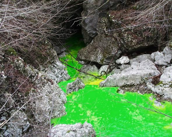
14 Dragonja River catchment area tracing test Venela near Buje ( ) 16 kg uranine monitoring objects: Gabrijeli Bužin Škudelin dig-well in Savudrija spring near St. Lovretić church in Savudrija Gradole spring Bulaž spring apparent velocity 2,07 cm/s according to Regulations for water protection zones must be in III. zone (now in II. zone limitation of development of Buje region) 20 koncentracija trasera (μg/l) traser ubačen u 13:00 sati Dijagram istjecanja trasera na izvoru Gabrijeli pojava trasera u 7:00 sati datum


15 Mirna River catchment area This springs and Butoniga reservoir are the base for the water-supply of Istria MLINI cca 20 l/s GRADOLE 540 l/s BULAŽ 200 l/s SVETI IVAN 150 l/s BUTONIGA RESERVOIR 81 mil m 3 Almost whole in Croatia, except minor part which surface drain to the Bulaž spring and carbonate part of the catchment in the hinterland of Mlini spring


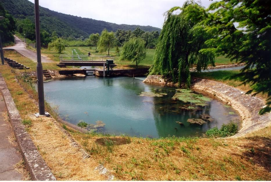
16 Sveti Ivan Bulaž Gradole

17 Butoniga Mlini

 Pod Jelšun (Torpedo) (80 l/s in min.; > 2 m 3 /s in max.")
18 Kvarner Bay and western part of Rijeka catchment area Important springing zone in coastal area In Opatija springs are not captured problems with salt water intrusion Kristal Admiral 0,5 1 m 3 /s 3. Maj (Rijeka) In western part of Rijeka springs are mostly captured for industrial water Preluka (coastal) Kantrida (coastal) 3. Maj (50 l/s in min.; > 1 m 3 /s in max.) Pod Jelšun (Torpedo) (80 l/s in min.; > 2 m 3 /s in max.) INA Mlaka (350 l/s) Rikard Benčić ( l/s) Kristal (Opatija) Admiral (Opatija)
19 very big catchment area no one spring captured for the water-supply part of the catchment is in Slovenia (Podgrad area and Novokračine area) tracing test in Novokračine ( ) tracing test in Podgrad region is in the programme for the 3rd phase of the project Kvarner Bay and western part of Rijeka catchment area


 well in INA Mlaka spring R.")
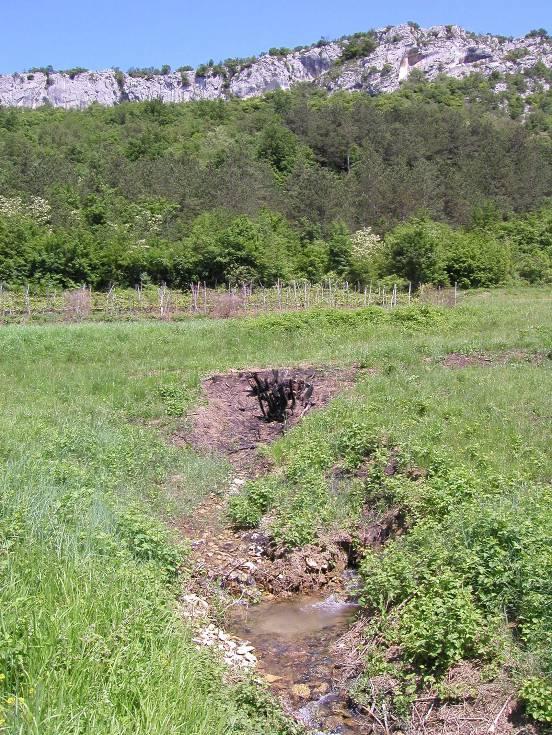
20 temporary swallow-hole in Novokračine of Sušački stream which occurring on impermeable flysch deposits and swallow-hole is on the contact with Cretaceous limestones flow rate is from 0 l/s to 10 m 3 /s best time for tracing is when the flow rate is about 350 l/s Novokračine injected 30 kg of uranine monitoring objects: spring in the camp in Medveja Kristal (Opatija) Preluka coastal spring Kantrida coastal spring spring in shipyard 3. Maj Pod Jelšun spring (Torpedo factory) well in INA Mlaka spring R. Benčić Zvir Rječina River spring
21 tracing test in Novokračine ( ) proved connection with coastal springs in Opatija and western part of Rijeka apparent velocities from 0,57 to 0,77 cm/s Kvarner Bay and western part of Rijeka catchment area
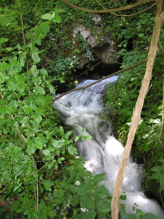
22 Rijeka springs catchment area The most valuable drainage unit in research area main concentration of discharge in canyon of Rječina River and in the Martinšćica valley Complex geological condition are reflected on hydrogeological situation Snježnik, Obruč recharge area Rječina River spring and NW edge of Grobničko polje zone of temporary discharge Springs in Rijeka zone of permanent discharge Snežnik mountain in Slovenia in the catchment area of Ilirska Bistrica spring (SI) and in the catchment areas of Rječina and Zvir (HR) in protection zones of both group of springs (overlapping) proposed tracing test Rječina River spring 1400 l/s 1400 l/s l/s (Zvir II) MARTINŠĆICA 260 l/s

")
")

23 Rječina River spring - dry Zvir (1400 l/s) Zvir II (600 l/s) Rječina River spring (1400 l/s) Martinšćica valley (260 l/s)
 22.05.2004.")

 Lužac Grobnik polje (HR)")
 Snežnik Grad (SI) Rječina River spring 0,49 cm/s, but")

24 Rijeka springs catchment area Tracing test Črna Draga (Snežnik) location of tracer injection is natural pit found by the help of Slovenian speleologists pit is at 1400 m a.s.l. monitoring objects: Rječina River spring (HR) Zvir (HR) Rastinčica Grobnik polje (HR) Lužac Grobnik polje (HR) Čabranka River spring (HR) Ilirska Bistrica (SI) Knežak (SI) Snežnik Grad (SI) Rječina River spring 0,49 cm/s, but higher concentration of tracer Zvir spring 0,68 cm/s velocities appropriate to IV. protection zone Rječina River spring 1400 l/s 1400 l/s l/s (Zvir II) MARTINŠĆICA 260 l/s
25 Measurement of temperature and CND on the springs (monthly) According to WFD (2000/60/EC) CND value is one of the main parameters for determining of chemical status of groundwater Good status - without big changes of CND Bad status - impact of the salt water intrusion Monitoring net of CND and T in Croatia: Rječina River spring 325 m a.s.l. Zvir 2 m a.s.l. Kristal coastal Admiral coastal Sveti Ivan 35 m a.s.l. Bulaž 17 m a.s.l. Gradole 2 m a.s.l. Rijeka Opatija Mirna
26 SPRING ELEVATION (m a.s.l.) CND (μs/cm) TEMPERATURE ( C) RječinaRiver spring ,3 Zvir ,6 Kristal ,5 Admiral ,7 Sveti Ivan ,1 Bulaž ,4 Gradole ,7 Three basic groups: - springs in Rijeka the lowest CND and T - springs in Opatija very high CND impact of the sea water - springs in Istria higher T (because of average annual air temperature in catchment) and CND (big part of catchments built of flysch deposits)
27 Hydrological analyses analyze based on existing hydrological stations huge number of hydrologic stations, but only three has 30-year data series: Buzet (Mirna) Ponte Porton (Mirna) Grohovo (Rječina) in analyze included discharge data from springs Gradole, Sv.Ivan, Bulaž, Zvir, and partly Rječina River spring objectives of hydrological analyses: analyze of discharge on the springs (minimum, maximum, average discharge) analyze of surface flow rate estimation of water balance in different catchment areas
28 CATCH MENT I NAME OF CATCHMENT Umaški potok and coastal springs between Mirna and Dragonja area (km 2 ) precipi tation (mm) tempera ture (0 C ) Specific flow q SR (l/s*km 2 ) Q SR (m 3 /s) Annual outflow coefficient K METHOD 100, ,4 7,03 0,70 0,23 Langbein II Dragonja 218, ,4 10,81 2,37 0,33 Langbein III Bulaž spring 104, ,9 17,24 1,80 0,43 Langbein IV Mirna catchment (except Bulaž) 602, ,4 16,79 10,12 0,43 Langbein III+IV Mirna River catchment 706, ,3 16,85 11,92 0,43 Langbein V Rižana spring catchment 244, ,5 26,10 8,10 0,54 Langbein USING OF LANGBEIN METHOD ON THE WHOLE ANALYZED CATHMENT AREAS VI Kvarner Bay catchment 365, ,3 39,24 14,35 0,64 Langbein VII Reka catchment 188, ,5 40,11 7,58 0,67 Langbein VIII Western part of Rijeka 141, ,5 40,57 5,76 0,63 Langbein IX Rijeka catchment (Rječina, Zvir and Martinšćica) 395, ,9 65,31 25,82 0,77 Langbein USING OF COMBINED METHODS OF LANGBEIN AND TURC VI Kvarner Bay catchment 365, ,3 41,57 15,21 0,68 Langbein &Turc VII Reka catchment 188, ,5 42,20 7,97 0,70 Langbein & Turc VIII Western part of Rijeka 141, ,5 43,08 6,11 0,67 Langbein & Turc IX Rijeka catchment (Rječina, Zvir and Martinšćica) 395, ,9 69,20 27,36 0,82 Turc
29 Hydrogeochemical research very important to establish simultaneous and standardized monitoring and sampling, analytical working and common interpretation of Slovenian and Croatian researchers
30 Groundwater quality almost all springs in research area in Croatia are below maximum allowed concentration for drinking waters but on some springs there were indications of anthropogenic impact (higher concentrations of nitrates on Gradole and Bužin spring) Gabrijeli and Bužini increasing bacteriological composition and temporary higher values than maximum allowed value for turbidity, microorganism, mineral oil and fecal streptococcus 6 2,4 5 4 IV/2001 VIII/2001 XI/2001 III/2002 VI/2002 X/2002 II/2003 VI/2003 IX/2003 2,3 2,2 2,1 2 1,9 1,8 1,7 1,6 1,5 IV/2001 VIII/2001 XI/2001 III/2002 VI/2002 X/2002 II/2003 VI/2003 IX/2003 1,20 1,00 1,4 NO3-N (mg/l) 3 2 PO 4-P (mg/l) 1,3 1,2 1,1 1 0,9 0,8 KPK (mgo 2/l) 0,80 0,60 0,7 0,6 0,5 0,40 1 0,4 0,3 0,2 MDK 0,20 0,1 0 0 Čabranka Rječina Zvir Kristal Sv. Ivan Bulaž Gradole Abrami Snežnik Bistrica Knežak Rižana Bužin Odolina Izola Sečovje D-1 D-2 Čabranka Rječina Zvir Kristal Sv. Ivan Bulaž Gradole Abrami Snežnik Bistrica Knežak Rižana Bužin Odolina Izola Sečovje D-1 D-2 0,00 Čabranka Rječina Zvir Kristal Sv. Ivan Bulaž Gradole Abrami concentration of nitrate orthophosphate chemical oxygen consumtion
31 Protection zones analyses analyzed in 2003 valid protection zones and their relation to proposal of novelation of protection zones (RGN, 2003; recent valid protection zones) some problems existed and overlapping of protection zones in Croatia and Slovenia existed mostly is the problems of old protection zones (valid before independency of Croatia and Slovenia) today zones are defined in each country until the state border not good because the most vulnerable places has to be protected regardless in which country they are

32 NECESSARY: third phase of the project is MISSING vulnerability map, hazard map and risk map will delineate most vulnerable parts of catchments and parts of the catchments where the some improvement programs are needed after preparation of new protection zones map in the area of northern Istria some overlapping has to be emphasized and due to the protection measures level the protection has to be established also in neighbouring country DECISION HAS TO BE MADE ON THE COUNTY LEVEL FOR THE ZONES TO BECOME LEGAL!!!
33 What has to be done in the third phase to finish the project for the area between Kvarner and Trieste Bay?? continuation of hydrogeological measurements on springs (T, CND) Bulaž, Sveti Ivan, Rječina, Zvir, Čabranka, Kristal, Gradole, Mlini tracing test in the border area of catchments Rižana, Sveti Ivan and Kvarner Bay processing of quality and quantity data and definition of trends final hydrological research on the Slovenian side Hydrogeochemical research definition of residence time in aquifers detachment of basic flow from overflow (separation of hydrograms by stabile isotopes) hydrogeochemical and isotope-hydrological model vulnerability, risk and hazard map for all catchment areas in research area of Croatia proposal of permanent monitoring of quality and quantity of transboundary water bodies proposal of changing of protection zones according to the protection measures in Croatian and Slovenian regulations Common GIS of all data


34 Thanks for Your attention!!!
Danube River Basin District
 Ministry of Agriculture, Forestry and Water Management June 18 th, 2004 Danube River Basin District Part B - Report 2003 CROATIA Information required according to Art. 3 (8) and Annex I of the EU Water
Water resources cycle in karst (feasibility studies and engineering design; case studies)
") Water resources cycle in karst (feasibility studies and engineering design; case studies) Prof. emeritus Ognjen Bonacci Faculty of Civil Engineering, Architecture and Geodesy, Split University E-mail:
Water resources cycle in karst (feasibility studies and engineering design; case studies) Prof. emeritus Ognjen Bonacci Faculty of Civil Engineering, Architecture and Geodesy, Split University E-mail:
Post Congress excursions*:
 Post Congress excursions*: 1. Dubrovnik Ombla - Popovo polje (Vjetrenica) (BiH) HE Trebinje (BiH) Grahovsko polje (MNE) The Boka Kotorska Springs and Kotor Old town (UNESCO heritage site) (MNE) Dubrovnik
Towards practical Guidance for Sustainable Sediment Management using the Sava River as a showcase
 UNIVERSITY OF ZAGREB FACULTY OF CIVIL ENGINEERING WATER RESEARCH DEPARTMENT Towards practical Guidance for Sustainable Sediment Management using the Sava River as a showcase Damir Bekić, Ph.D., M.Sc.,
Management of Transboundary Karst Aquifers
 KARST RESEARCH INSTITUTE SRC SASA Speleological Association of Slovenia Slovenian National Commission for UNESCO Karst Commission IGU International Union of Speleology UIS 15 th INTERNATIONAL KARSTOLOGICAL
Adriatic karstic estuaries, their characteristics and evolution
 Conférence Méditerranéenne Côtière et Maritime EDITION 4, SPLIT, CROATIA (2017) Coastal and Maritime Mediterranean Conference Disponible en ligne http://www.paralia.fr Available online Adriatic karstic
The Timok River Basin in Serbia
 The Timok River Basin in Serbia UNECE Workshop on Integrated Transboundary Water Resources Management in SEE, Sarajevo, 18-20 May, 2009 Dragana Ninković, Dipl.-Ing. Dušan Dobričić, Dipl.-Ing. Content 1.
Outline. The main objectives. The main objectives. Distribution of stable isotopes in the Sava River in Serbia
 Distribution of stable isotopes in the Sava River in Serbia N. MILJEVIĆ 1, D. GOLOBOČANIN 1, M. NADEŽDI DIĆ, N. OGRINC 3 1 Vinča a Institute of Nuclear Sciences, POB 5, 11001 Belgrade, Serbia Republic
Water resource situation of the Republic of Djibouti
 Water resource situation of the Republic of Djibouti Omar ASSOWE DABAR Integrating Groundwater Management within River Basins 15-17 January 2019 Nairobi, Kenya Regional Training Workshop on Introduction
Seasonal Variability of the Groundwater Regime for Several Aquifers in Bulgaria Tatiana Orehova 1
 Seasonal Variability of the Groundwater Regime for Several Aquifers in Bulgaria Tatiana Orehova 1 The purpose of the paper is to analyse the seasonal variability of the groundwater regime for several aquifers
INCO: International Scientific Cooperation Projects ( )
") INCO: International Scientific Cooperation Projects (1998-2002) Contract number: ICA2-CT-2002-10009 Covering period from January 1, 2003 to December 31, 2005 Anthropol.prot Title: STUDY OF ANTHROPOGENIC
INCO: International Scientific Cooperation Projects (1998-2002) Contract number: ICA2-CT-2002-10009 Covering period from January 1, 2003 to December 31, 2005 Anthropol.prot Title: STUDY OF ANTHROPOGENIC
Croatia completes inventory of wetlands
 Croatia completes inventory of wetlands 16 October 2006 Croatia CRO-WET - Croatian Wetland Inventory SGF project completed The Croatian State Institute for Nature Protection (SINP) carried out a comprehensive
Protection and Sustainable Use of the Dinaric Karst Transboundary Aquifer System
 Protection and Sustainable Use of the Dinaric Karst Transboundary Aquifer System Second Workshop "River Basin Commissions and Other Joint Bodies for Transboundary Water Cooperation: Technical Aspects "
CO-OPERATION IN DANUBE RIVER BASIN - THE ROLE OF SHMI SLOVENSKÝ HYDROMETEOROLOGICKÝ ÚSTAV
 CO-OPERATION IN DANUBE RIVER BASIN - THE ROLE OF SHMI WMO RAVI Hydrological Forum 2016 Oslo, 1 Danube, the 2nd longest in Europe. 2857 km Flows across 10 European states River basin - 817 000 km2 1/11
Extraordinary summer flood in a karst area: case study in Croatia
 The Extremes ofthe Extremes: Exlraordinan' Floods (Proceedings ol'a symposium held at Reykjavik. Iceland. July 2000). IAHS Publ. no. 271. 2002. 133 Extraordinary summer flood in a karst area: case study
Implementation of the Water Convention, including its complementary role to the EU Water Framework Directive
 Implementation of the Water Convention, including its complementary role to the EU Water Framework Directive Experience of Serbia Dragana Milovanović Ministry of Agriculture, Forestry and Water Management
Protection and Sustainable Use of the Dinaric Karst Transboundary Aquifer System
 Protection and Sustainable Use of the Dinaric Karst Transboundary Aquifer System What is DIKTAS? DIKTAS is a project initiated by the aquifer-sharing states and supported by GEF - Global Environment Facility.
THE IMPLEMENTATION OF EWFD/WFD IN THE REGION OF VOJVODINA WITHIN JOINT SLOVAK-SERBIA SERBIA PROJECTS
 Towards Integrated River Basin Management The 55 th Anniversary of the Founding of the Water Research Institute THE IMPLEMENTATION OF EWFD/WFD IN THE REGION OF VOJVODINA WITHIN JOINT SLOVAK-SERBIA SERBIA
Geologia Croatica. The conceptual hydrogeological model of the Plitvice Lakes. Božidar Biondić, Ranko Biondić and Hrvoje Meaški AB STRA CT
 63/2 195 206 16 Figs. 1 Tab. Zagreb 2010 195 The conceptual hydrogeological model of the Plitvice Lakes Božidar Biondić, Ranko Biondić and Hrvoje Meaški AB STRA CT Faculty of Geotechnical Engineering,
Implementation of WFD in Serbia and Montenegro
 Ministry of Agriculture, Forestry and Water Management Directorate for Water Implementation of WFD in Serbia and Montenegro Nikola Marjanovic, PhD Civ. Eng. SERBIA AND MONTENEGRO SERBIA Area: 88.361 km
Presentation from 2015 World Water Week in Stockholm. The authors, all rights reserved. SIWI siwi.org
 Presentation from 2015 World Water Week in Stockholm www.worldwaterweek.org The authors, all rights reserved SIWI siwi.org WORLD WATER WEEK Stockholm, 23 th August 2015 Co-operative water governance: catalyst
International Sava River Basin Commission
 International Sava River Basin Commission Pilot project on climate change: Building the link between the Flood Risk Management planning and climate change assessment in the Sava River Basin climate change
International Groundwater Resources Assessment Centre. Transboundary Aquifers within the Second Assessment: the case of Dinaric Karst Aquifer System
 International Groundwater Resources Assessment Centre Transboundary Aquifers within the Second Assessment: the case of Dinaric Karst Aquifer System Dr Neno Kukuric Sarajevo, 2009 Content of the presentation
DETECTION OF WATER LEAKS IN FOUM EL-GHERZA DAM (ALGERIA)
") Ninth International Water Technology Conference, IWTC9 2005, Sharm El-Sheikh, Egypt 581 DETECTION OF WATER LEAKS IN FOUM EL-GHERZA DAM (ALGERIA) N. Hocini and A.S. Moulla Applied Hydrology and Sedimentology
Ninth International Water Technology Conference, IWTC9 2005, Sharm El-Sheikh, Egypt 581 DETECTION OF WATER LEAKS IN FOUM EL-GHERZA DAM (ALGERIA) N. Hocini and A.S. Moulla Applied Hydrology and Sedimentology
Terms of Reference (ToR) for a Short-Term assignment
 for a Short-Term assignment") Terms of Reference (ToR) for a Short-Term assignment Technical assistance requested Expert for climate change mitigation and adaptation Project Title Outline of the Climate Adaptation Strategy and basin-wide
Terms of Reference (ToR) for a Short-Term assignment Technical assistance requested Expert for climate change mitigation and adaptation Project Title Outline of the Climate Adaptation Strategy and basin-wide
International Sava River Basin Commission - An example of EU/non EU country cooperation in water management
 International Sava River Basin Commission - An example of EU/non EU country cooperation in water management Improvement and co-operation possibilities in the water sector with non-eu countries Ulm, 29
Invitation to CROSS-BORDER DRINKING WATER MANAGEMENT. International Symposium: 29 th January Rijeka, Croatia
 Invitation to International Symposium: CROSS-BORDER DRINKING WATER MANAGEMENT 9 th January 06 Rijeka, Croatia Faculty of Civil Engineering University of Rijeka Radmile Matejčić 3 5000 Rijeka Croatia Rijeka,
ANALYSIS OF INADEAUTE WATER QUALITY OD THE RESERVOIR VONARJE/SUTLA LAKE AND POSSIBILITY OF RESTORATION AND UTILIZATION
 EC project on Integration of Natural Water Retention Measures in river basin management The 1 st Danube Region Workshop ANALYSIS OF INADEAUTE WATER QUALITY OD THE RESERVOIR VONARJE/SUTLA LAKE AND POSSIBILITY
Ecohydrology of karst poljes and their vulnerability
 Ecohydrology of karst poljes and their vulnerability Prof. emeritus O. Bonacci Faculty of Civil Engineering, Architecture and Geodesy, Split University, 21000 Split, Matice hrvatske 15, Croatia E-mail:
REPORT of the visit of eminent experts in karstоlogy Derek Ford and Petar Milanović to the Centre for Karst Hydrogeology
 REPORT of the visit of eminent experts in karstоlogy Derek Ford and Petar Milanović to the Centre for Karst Hydrogeology In honour of the Petar Milanović s 80 th birthday, Centre for Karst Hydrogeology
The Isonzo/Soca river basin
 Geneva September 8 th 2014 The Isonzo/Soca river basin Status and perspective on the possible Alpine river basin to be assessed The Alpine Convention Water management, risk management and adaptation to
IRRIGATION IN AGRICULTURE AND CLIMATE CHANGE. Agrotech, 2017
 IRRIGATION IN AGRICULTURE AND CLIMATE CHANGE Agrotech, 217 Legislation Current situation Needs, possibilities, existing and potential problems Irrigation is regulated with the Water Law, and when it comes
Blocking Sea Intrusion in Brackish Karstic Springs
 European Water 1/2: 17-23, 3. 3 E.W. Publications Blocking Sea Intrusion in Brackish Karstic Springs The Case of Almiros Spring at Heraklion Crete, Greece A. Maramathas, Z. Maroulis, D. Marinos-Kouris
Development of the Danube River Basin District Management Plan
 DRAFT-8 DOC-101 23-Nov-2005 Development of the Danube River Basin District Management Plan - Strategy for coordination in a large international river basin River Basin Management Expert Group Prepared
Procedia Earth and Planetary Science 13 ( 2015 ) th Applied Isotope Geochemistry Conference, AIG-11 BRGM
 th Applied Isotope Geochemistry Conference, AIG-11 BRGM") Available online at www.sciencedirect.com ScienceDirect Procedia Earth and Planetary Science 13 ( 2015 ) 256 260 11th Applied Isotope Geochemistry Conference, AIG-11 BRGM Investigating the Origin and Interaction
Available online at www.sciencedirect.com ScienceDirect Procedia Earth and Planetary Science 13 ( 2015 ) 256 260 11th Applied Isotope Geochemistry Conference, AIG-11 BRGM Investigating the Origin and Interaction
The Danube Experience
 The Danube Experience Dealing with Hydromorphological Issues the Danube Experience Philip Weller Executive Secretary, ICPDR Danube River Basin- Overview The Danube River Basin is the most international
Protection and Sustainable Use of the DINARIC KARST AQUIFER SYSTEM
 Protection and Sustainable Use of the DINARIC KARST AQUIFER SYSTEM 1. the context What is Karst? Karst is a special type of geologic environment that is formed by dissolution and corrosion of soluble rocks,
Hazards caused by natural and anthropogenic changes of catchment area in karst
 Natural Hazards and Earth System Sciences (004) 4: 655 66 SRef-ID: 684-998/nhess/004-4-655 European Geosciences Union 004 Natural Hazards and Earth System Sciences Hazards caused by natural and anthropogenic
PROLINE-CE. D.C.3.8 Croatian pilot actions EXCURSION BROCHURE. Imotsko polje and South Dalmatia springs
 D.C.3.8 Croatian pilot actions PROLINE-CE Imotsko polje and South Dalmatia springs EXCURSION BROCHURE EXCURSION BROCHURE D.C.3.8 Pilot actions Imotsko polje and South Dalmatia springs CROATIAN GEOLOGICAL
FUNActive Tours GmbH. Self-guided tour approx km 5 days / 4 nights. Description. Characteristics of the route
 cycleholiday - Short break ISTRIA FROM TRIESTE TO POREC Self-guided tour approx. 115-140 km 5 days / 4 nights Description Start of this bicycle tour is Trieste, the former Habsburg seaport seated at the
43. DEVELOPMENT AND DISTRIBUTION OF TOURISM
 Tourism Tourism is one of the world s largest industries. In many regions it is also the greatest source of revenue and employment. Tourism demand is based on the values and needs of modern tourists, while
Croatia - Walking Adventure Through Green Istria Hiking Tour 2019 Individual Self-Guided 7 days/6 nights
 Croatia - Walking Adventure Through Green Istria Hiking Tour 2019 Individual Self-Guided 7 days/6 nights Imagine walking through green countryside full of vineyards, olive trees, rivers and forests, full
Shrubs and alpine meadows represent the only vegetation cover.
 Saldur river General description The study area is the upper Saldur basin (Eastern Italian Alps), whose elevations range from 2150 m a.s.l. (location of the main monitoring site, LSG) and 3738 m a.s.l.
Karst Without Boundaries
 International Conference and Field Seminar Karst Without Boundaries In partnership of In collaboration with Other supporting partners and organizations P R O C E E D I N G S Edited by N. Kukurić, Z. Stevanović,
Framework Agreement on the Sava River Basin and its implementation
 Framework Agreement on the Sava River Basin and its implementation Dejan Komatina, Ph.D. Civ. Eng., Secretary, ISRBC Samo Grošelj, Deputy Secretary Overview Introduction on the Sava river basin Establishment
112 SYSTEM IN BOSNIA AND HERZEGOVINA
 Ministry of Security of Bosnia and Herzegovina 112 SYSTEM IN BOSNIA AND HERZEGOVINA Mirnesa Softic Operational Communication Center BH - 112 Ministry of Security of Bosnia and Herzegovina Zagreb, 16 November
Zoran Đuroković, B. Sc. (Civ.Eng.) Davor Haničar, B. Sc. (Civ.Eng.) Ladislav Grđan, B. Sc. (Civ.Eng.) Silvio Brezak, B. Sc. (Civ.Eng.
 Davor Haničar, B. Sc. (Civ.Eng.) Ladislav Grđan, B. Sc. (Civ.Eng.) Silvio Brezak, B. Sc. (Civ.Eng.") FLOOD PROTECTION EXPERIENCES ON THE DRAVA RIVER BASIN IN CROATIA Maribor, September 23-25 2008 Zoran Đuroković, B. Sc. (Civ.Eng.) Davor Haničar, B. Sc. (Civ.Eng.) Ladislav Grđan, B. Sc. (Civ.Eng.) Silvio
FLOOD PROTECTION EXPERIENCES ON THE DRAVA RIVER BASIN IN CROATIA Maribor, September 23-25 2008 Zoran Đuroković, B. Sc. (Civ.Eng.) Davor Haničar, B. Sc. (Civ.Eng.) Ladislav Grđan, B. Sc. (Civ.Eng.) Silvio
BICYCLE HOLIDAY. ISTRIA THE SUNNY PENINSULA IN THE MEDITERRANEAN SEA (approx km, 08 days / 07 nights, self-guided tour)
") BICYCLE HOLIDAY ISTRIA THE SUNNY PENINSULA IN THE MEDITERRANEAN SEA (approx. 190-290 km, 08 days / 07 nights, self-guided tour) Description Start of this bicycle tour is Trieste, the former Habsburg seaport
BICYCLE HOLIDAY ISTRIA THE SUNNY PENINSULA IN THE MEDITERRANEAN SEA (approx. 190-290 km, 08 days / 07 nights, self-guided tour) Description Start of this bicycle tour is Trieste, the former Habsburg seaport
ICPDR FP-EG project overview
 ICPDR FP-EG project overview 9 th Steering Group meeting of PA5 of the EUSDR Management of Environmental Risks KÁROLY GOMBÁS CHAIRMAN FLOOD PROTECTION EXPERT GROUP (FP-EG) INTERNATONAL COMISSION OF THE
FORECASTING OF INDUSTRIAL ROUNDWOOD PRODUCTION FOR THE PART OF SOUTH-EAST EUROPE. Maja Moro, Darko Motik, Denis Jelačić, Marek Drimal
 FORECASTING OF INDUSTRIAL ROUNDWOOD PRODUCTION FOR THE PART OF SOUTH-EAST EUROPE Maja Moro, Darko Motik, Denis Jelačić, Marek Drimal INTRODUCTION The South-East Europe area is the most diverse, heterogeneous
HYDRAULIC STUDY OF THE NERETVA RIVER (FROM MOSTAR TO THE BORDER WITH THE REPUBLIC OF CROATIA)
") HYDRAULIC STUDY OF THE NERETVA RIVER (FROM MOSTAR TO THE BORDER WITH THE REPUBLIC OF CROATIA) B.Sc. Draženka Kvesić, civ. eng. PRONING DHI d.o.o., Račkog 3, Zagreb Croatia. Email: drazenka@proning-dhi.hr.
HYDRAULIC STUDY OF THE NERETVA RIVER (FROM MOSTAR TO THE BORDER WITH THE REPUBLIC OF CROATIA) B.Sc. Draženka Kvesić, civ. eng. PRONING DHI d.o.o., Račkog 3, Zagreb Croatia. Email: drazenka@proning-dhi.hr.
Breakthrough of the Tunnel with the Biggest Overburden in Croatia
 289 Breakthrough of the Tunnel with the Biggest Overburden in Croatia Redovnikovi, L., Ališi, I., and Džapo, M. University of Zagreb, Faculty of Geodesy, Fra Andrija Ka i a Mioši a 26, 1 Zagreb, Croatia,
Ministry of Communications and Transport
 more than 100,000 houses and other buildings in Bosnia and Herzegovina (May 2014) were no longer fit to use and that over a million people had been cut off from clean water supplies. Ministry of Communications
Danube River Basin. a source for transboundary cooperation. Exploring the Results and Potential for Transboundary Water Management Cooperation
 Danube River Basin a source for transboundary cooperation Exploring the Results and Potential for Transboundary Water Management Cooperation Philip Weller ICPDR, Executive Secretary Joint Meeting EUWI
Uses of maritime space and main conflicts related to MSP implementation in Croatia
 Uses of maritime space and main conflicts related to MSP implementation in Croatia CROATIA IN FIGURES Basic information (Croatian Bureau of Statistics,211.) Total area: 87 661 km 2 Territorial sea of 12
Catchment area - 30 min drive time inhabitants - 1 hour drive time inhabitants - 2 hours drive time
 Administrative Department for the Communal System and Urbanisation CLASS: NUMBER: Varaždin, 1 October 2014 Introduction Position of the Airport with regard to the Varaždin County and the Wider Region;
The Croatian Adventure 2018
 The Croatian Adventure 2018 Info This scenic cycling tour will take you from Croatia s inland mountain region to the Adriatic coast through five national parks: Risnjak, Northern Velebit, Plitvice Lakes,
The impact of tourism on separate waste collection in Zadar County, Republic of Croatia
 The impact of tourism on separate waste collection in Zadar County, Republic of Croatia Aleksandra Anić Vučinić*, Dino Perović**, Hrvoje Dokoza***, Vitomir Premur*, Lucija Radetić* *Department of Environmental
MIÑO O AND LIMIA BASINS
 Miño-Sil MIÑO O AND LIMIA BASINS José Álvarez Díaz Sil River Basin District s s Planning Office, Spain WORKSHOP ON TRANSBOUNDARY WATER RESOURCES BUDAPEST, HUNGARY, 8-10 FEBRUARY 2011 INDEX 1. OVERVIEW
SUPPORT TO WATER RESOURCES MANAGEMENT IN THE DRINA RIVER BASIN DRAFT ROOF REPORT INTRODUCTION AND GENERAL APPROACH
 SUPPORT TO WATER RESOURCES MANAGEMENT IN THE DRINA RIVER BASIN DRAFT ROOF REPORT INTRODUCTION AND GENERAL APPROACH Nadja Zeleznik, REC Public Concultation Beograd, Serbia, 4 July 2017 1 1. Introduction
Transboundary and Not-Tranboundary Aquifers in the Basin
 Second Assessment of Transboundary Rivers, Lakes and Groundwaters under the UNECE Water Convention Transboundary and Not-Tranboundary Aquifers in the Basin Slovak Hydrometeorological Institute Bratislava,
ARTIFICIAL RECHARGE OF THE UNDERGROUND KARSTIC AQUIFER OF FARSALA AREA (THESSALY, CENTRAL GREECE) 1
 1") ARTIFICIAL RECHARGE OF THE UNDERGROUND KARSTIC AQUIFER OF FARSALA AREA (THESSALY, CENTRAL GREECE) 1 MARIOLAKOS, I. 2, FOUNTOULIS, I., SPYRIDONOS, E., MARIOLAKOS, D., ANDREADAKIS, EM. ABSTRACT The area
ARTIFICIAL RECHARGE OF THE UNDERGROUND KARSTIC AQUIFER OF FARSALA AREA (THESSALY, CENTRAL GREECE) 1 MARIOLAKOS, I. 2, FOUNTOULIS, I., SPYRIDONOS, E., MARIOLAKOS, D., ANDREADAKIS, EM. ABSTRACT The area
TRANSBOUNDARY ASSESSMENT NP PLITVICE LAKES / NP UNA
 Ognjen Škunca & Željka Rajković consultants TRANSBOUNDARY ASSESSMENT NP PLITVICE LAKES / NP UNA 3 2 1 The studied TB region natural historical border between Croatian and B&H in the study area defined
Hydrological study for the operation of Aposelemis reservoir Extended abstract
 Hydrological study for the operation of Aposelemis Extended abstract Scope and contents of the study The scope of the study was the analytic and systematic approach of the Aposelemis operation, based on
GODINA XI SARAJEVO, BROJ 2 TOURISM STATISTICS. Tourism in BIH, February 2017
 number of nights GODINA XI SARAJEVO, 06.04.2017. BROJ 2 TOURISM STATISTICS Tourism in BIH, February 2017 In February 2017 tourists realised 56,042 tourist arrivals in Bosnia and Hercegovina which represent
The sunny peninsula in the Mediterranean Sea Self-guided tour 8 days /7 nights
 hikeholiday The sunny peninsula in the Mediterranean Sea Self-guided tour 8 days /7 nights Description Starting point for this hiking tour is Trieste, the former Habsburg seaport seated at the foothills
Excursion guidebook. Dubrovnik (Ombla) - Blue and Red Lakes (Imotski) - Gacka River - Plitvička Lakes - Zagreb - Ljubljana
 - Blue and Red Lakes (Imotski) - Gacka River - Plitvička Lakes - Zagreb - Ljubljana") 44 th Annual Congress of the IAH Groundwater Heritage and Sustainability Excursion guidebook Dubrovnik (Ombla) - Blue and Red Lakes (Imotski) - Gacka River - Plitvička Lakes - Zagreb - Ljubljana 25 th
44 th Annual Congress of the IAH Groundwater Heritage and Sustainability Excursion guidebook Dubrovnik (Ombla) - Blue and Red Lakes (Imotski) - Gacka River - Plitvička Lakes - Zagreb - Ljubljana 25 th
Common Principles and Technical Requirements for Pan-European River Information Services (RIS)
") Common Principles and Technical Requirements for Pan-European River Information Services (RIS) Joint Presentation of the and the Geneva, October 2008 Content Inland Waterways of the Region Legal Background
Common Principles and Technical Requirements for Pan-European River Information Services (RIS) Joint Presentation of the and the Geneva, October 2008 Content Inland Waterways of the Region Legal Background
IPA Project Building Resilience to Disasters in Western Balkans and Turkey. Enhancing hydrological data management and exchange procedures
 IPA Project Building Resilience to Disasters in Western Balkans and Turkey Enhancing hydrological data management and exchange procedures Banja Luka, 15-16 April 2014 MEETING REPORT 1. Introduction In
Energy Community Regulatory Board Status review of transmission tariffs and treatment of cross - border transmission flows and recommendations By
 Energy Community Regulatory Board Status review of transmission tariffs and treatment of cross - border transmission flows and recommendations By Aleksandar Popadic, AERS Senior Natural Gas Expert 5 th
Overview. Sava River Basin. Sava River Basin. Sava River Basin
 Overview Introduction on the Framework Agreement on the a basis for sustainable development of the region Framework Agreement on the (FASRB) and the International Commission (ISRBC) Approach to Sustainable
3.0 OVERVIEW OF HUECO BOLSON
 3.0 OVERVIEW OF HUECO BOLSON The Hueco Bolson covers about 2,500 square miles, or 1.6 million acres in New Mexico, Texas, and Chihuahua (Figure 3-1). In Texas, the Hueco overlies portions of El Paso and
Sava Commission Activities. DANUBE SKILLS KICK OFF EVENT, February 21, 2017, Bucharest
 Sava Commission Activities DANUBE SKILLS KICK OFF EVENT, February 21, 2017, Bucharest 1 Establishment of the ISRBC 2 Decay of SFRY a challenge to WRM in the Sava river basin Sava river used to be the biggest
Hrvatske autoceste d.o.o.
 HRVATSKA UDRUGA KONCESIONARA ZA AUTOCESTE S NAPLATOM CESTARINE / CROATIAN ASSOCIATION OF TOLL MOTORWAYS CONCESSIONAIRES NEWSLETTER MARCH 2009 Hrvatske autoceste d.o.o. HAC opens new sections on the A1
EXCURSIONS from Rijeka
 EXCURSIONS from Rijeka RIJEKA CITY TOUR Half-day excursion / 2-3h tour - Guided visit of Rijeka city center, a city most famous for being the most important port and harbour in Croatia. Rijeka has a very
Public Seminar 30 October 2018, Lisbon. Water sector in B&H
 Public Seminar 30 October 2018, Lisbon Water sector in B&H Ministry of Foreign Trade and Economic Relations www.mvteo.gov.ba Boško Kenjić, Head of Department Tel: +387 33 262 155 E-mail: bosko.kenjic@mvteo.gov.ba
Intermediate report. Letter of agreement FAO - GCB/RAB/013/ITA
 Treated waste water for sustainable production of valuable biomass, soil and water quality improvement and combating desertification in Algeria and Tunisia Letter of agreement FAO - GCB/RAB/013/ITA Intermediate
4 DAY LEISURE. Available incoming airports: Rijeka Pula Zagreb Ljubljana Trieste Treviso Venice. PRICE: $3849 single room supplement + $569.
 4 DAY LEISURE 90 3 NIGHTS 4 DAYS PRICE: $3849 single room supplement + $569 Available incoming airports: Buzet Motovun Rijeka Pula Zagreb Ljubljana Trieste Treviso Venice Kastav Preluk Volosko Opatija
Outstanding Balkan River landscapes a basis for wise development decisions. Slovenia
 Outstanding Balkan River landscapes a basis for wise development decisions Slovenia Table of Contents: 1. Hydromorphological intactness of rivers 2 2. Protected areas, karst poljes, estuaries/deltas and
Groundwater Vulnerability in Western Herzegovina
 1 Paper N 0 : V.11 Groundwater Vulnerability in Western Herzegovina Mladen Zelenika, Ivan Slišković, Božo Soldo Abstract: The full and partial hydrogeological barriers together with terrains of low and
Visit of Chinese representatives of the International Research Centre for Karst (IRCK) to the CKH
 to the CKH") Visit of Chinese representatives of the International Research Centre for Karst (IRCK) to the CKH The International Research Center on Karst (IRCK) was formed in 2008 in Guilin, China under the Auspices
Visit of Chinese representatives of the International Research Centre for Karst (IRCK) to the CKH The International Research Center on Karst (IRCK) was formed in 2008 in Guilin, China under the Auspices
How to develop resilient infrastructure (Global SDG9)
") How to develop resilient infrastructure (Global SDG9) 16-17 November 2017, Ljubljana, Slovenia Development of resilient rail infrastructure, practices in the Republic of Macedonia Darko Miceski Viktorija
How to develop resilient infrastructure (Global SDG9) 16-17 November 2017, Ljubljana, Slovenia Development of resilient rail infrastructure, practices in the Republic of Macedonia Darko Miceski Viktorija
Geologia Croatica 63/ Figs. Zagreb
 63/2 187 193 7 Figs. Zagreb 2010 187 Observations of stage and temperature dynamics in the epiphreatic caves within the catchment area of the Ljubljanica River (Slovenia) Franci Gabrovšek and Janez Turk
Hydrology Input for West Souris River IWMP
 Hydrology Input for West Souris River IWMP Prepared by: Mark Lee Manitoba Water Stewardship 1 1 1 Overall view of: drainage area watershed characteristics gauging stations meteorological stations Runoff
WATER MANAGEMENT IN ROMANIA. Elisabeta CSERWID National Institute of Hydrology and Water Management ROMANIA
 WATER MANAGEMENT IN ROMANIA Elisabeta CSERWID National Institute of Hydrology and Water Management ROMANIA 2 I - Water management in Romania Romania general information Location: S-E Europe Surface: 238,391
Jeneberang River. Serial No. : Indonesia-10 Location: South Sulawesi Area: 727 km 2 Origin: Mt. Bawakaraeng (2,833 MSL) Outlet: Makassar Strait
 Outlet: Makassar Strait") Jeneberang River Map of River Table of Basic Data Name: Jeneberang River Serial No. : Indonesia-10 Location: South Sulawesi S 5 10' 00" - 5 26' 00" E 119 23' 50" - 119 56' 10" Area: 727 km 2 Origin: Mt.
Jeneberang River Map of River Table of Basic Data Name: Jeneberang River Serial No. : Indonesia-10 Location: South Sulawesi S 5 10' 00" - 5 26' 00" E 119 23' 50" - 119 56' 10" Area: 727 km 2 Origin: Mt.
Paso Robles Groundwater Basin: Effects of Geothermal Waters on Water Quality and Availability
 Paso Robles Groundwater Basin: Effects of Geothermal Waters on Water Quality and Availability Jim Rytuba and Daniel Goldstein U.S. Geological Survey, Menlo Park, CA Paso Robles Intake from Lake Nacimiento
Croatian Highlights 26 th August 21 st September 2020
 Croatian Highlights 26 th August 21 st September 2020 Explore the Adriatic stunning coastline A country of stunning natural beauty and possibly Europe s finest coastline! Rugged limestone mountains, crystal
International Sava River Basin Commission
 International Sava River Basin Commission Pilot project on climate change: Building the link between the Flood Risk Management planning and climate change assessment in the Sava River Basin - climate change
J.M. Marques a, C. Matos b, P.M. Carreira c and M.O. Neves a
 GEOCHEMICAL AND ISOTOPIC TOOLS TO ASSESS CALDAS DA RAINHA THERMOMINERAL WATER SYSTEM ASCRIBED TO A KARST/FISSURED-POROUS ENVIRONMENT (PORTUGAL): A REVIEW J.M. Marques a, C. Matos b, P.M. Carreira c and
First penta-lateral biosphere reserve in the World - the story of Mura-Drava-Danube region
 First penta-lateral biosphere reserve in the World - the story of Mura-Drava-Danube region International workshop on defining transboundary conservation principles, 16-18 October 2013, Thayatal National
TRANSBOUNDARY COOPERATION ON WATER MANAGEMENT
 3 rd Istanbul International Water Forum European Regional Process towards the 7 th World Water Forum PLOVDIV TRANSBOUNDARY COOPERATION ON WATER MANAGEMENT Nicola Karnolski - Director of East Aegean Sea
Istria- Pula (Slovenia) 1:100K (English, Spanish, French, Italian And German Edition) By Freytag-Berndt
 1:100K (English, Spanish, French, Italian And German Edition) By Freytag-Berndt") Istria- Pula (Slovenia) 1:100K (English, Spanish, French, Italian And German Edition) By Freytag-Berndt If searched for a book by Freytag-Berndt Istria- Pula (Slovenia) 1:100K (English, Spanish, French,
Istria- Pula (Slovenia) 1:100K (English, Spanish, French, Italian And German Edition) By Freytag-Berndt If searched for a book by Freytag-Berndt Istria- Pula (Slovenia) 1:100K (English, Spanish, French,
Destruction of dolines: the examples from Slovene karst
 Destruction of dolines: the examples from Slovene karst dr. Gregor Kovačič (1) and dr. Nataša Ravbar (2) (1) University of Primorska, Faculty of humanities Koper, Science and Research Centre, Koper, Slovenia
THE REPUBLIC OF SERBIA MINISTRY OF ENVIRONMENTAL PROTECTION DEVELOPMENT OF THE ECOLOGICAL NETWORK IN SERBIA
 THE REPUBLIC OF SERBIA MINISTRY OF ENVIRONMENTAL PROTECTION DEVELOPMENT OF THE ECOLOGICAL NETWORK IN SERBIA Establishment of the Ecological Network in Serbia As a first step towards establishment of the
National and Regional Activities, Needs and Expectations
 National and Regional Activities, Needs and Expectations The perspective from the International Sava River Basin Commission International collaboration in the forecasting of river flows within the Sava
Water sustainability: new challenges and solutions IGU Commission for Water Sustainability Dubrovnik, 24 th to 28 th August 2014
 Water sustainability: new challenges and solutions Dubrovnik, 24th to 28th August 2014 FIRST CONFERENCE CIRCULAR and CALL FOR PAPERS Water sustainability: new challenges and solutions International Scientific
Abstract UDC 556.3(497.56) Izvleček UDK 556.3(497.56) Ranko Biondić, Hrvoje Meaški & Božidar Biondić: Hidrogeologija
 Izvleček UDK 556.3(497.56) Ranko Biondić, Hrvoje Meaški & Božidar Biondić: Hidrogeologija") COBISS: 1.02 Hydrogeology of the sinking zone of the Korana River downstream of the Plitvice Lakes, Croatia Hidrogeologija ponornega območja reke Korane dolvodno od Plitviških jezer, Hrvaška Ranko Biondić
COBISS: 1.02 Hydrogeology of the sinking zone of the Korana River downstream of the Plitvice Lakes, Croatia Hidrogeologija ponornega območja reke Korane dolvodno od Plitviških jezer, Hrvaška Ranko Biondić
Management of a Large The Danube. Mr. Mitja Bricelj ICPDR President Perth,13 October 2010
 Management of a Large International ti River Basin: The Danube Mr. Mitja Bricelj ICPDR President Perth,13 October 2010 From the Black Forest From the Black Forest to the Black Sea Human activities damaged
DUSAN SRDOC, NADA HORVATINCIC, and BOGOMIL OBELIC. Faculty of Veterinary Science, University of Zagreb,
 [Radiocarbon, Vol 25, No. 2, 1983,P 421-427] RADIOCARBON DATING OF TUFA IN PALEOCLIMATIC STUDIES DUSAN SRDOC, NADA HORVATINCIC, and BOGOMIL OBELIC Rudjer Boskovic Institute, Zagreb, Yugoslavia, PO Box