Management of Transboundary Karst Aquifers
|
|
|
- Samson Cross
- 6 years ago
- Views:
Transcription

1 KARST RESEARCH INSTITUTE SRC SASA Speleological Association of Slovenia Slovenian National Commission for UNESCO Karst Commission IGU International Union of Speleology UIS 15 th INTERNATIONAL KARSTOLOGICAL SCHOOL CLASSICAL KARST Management of Transboundary Karst Aquifers Postojna, 2007

2 Editorial board Janja Kogovšek, Janez Mulec, Metka Petrič, Mitja Prelovšek, Nataša Ravbar, Janez Turk Scientific committee Mitja Bricelj, Nathalie Doerfliger, Franci Gabrovšek, Janja Kogovšek, Borut Peric, Metka Petrič, Shammy Puri, Nataša Ravbar, Josip Rubinić, Tadej Slabe, Hans Zojer Cover figure Transboundary karst aquifers (see Fig. 6 for references) Published by Karst Research Institute, Scientific Research Centre of the Slovenian Academy of Sciences and Arts, Titov trg 2, SI-6230 Postojna, Slovenia Organizer Karst Research Institute, Scientific Research Centre of the Slovenian Academy of Sciences and Arts Supported by Slovenian Research Agency Slovenian National Commission for UNESCO Scientific Research Centre of the Slovenian Academy of Sciences and Arts Commune of Postojna Postojnska jama, turizem, d.d. Park Škocjanske jame, Slovenija Co-financed by the European Union Marie Curie Conferences and Training Courses SMART-KARST (MSCF )
3 15 th International Karstological School Classical Karst, Postojna, Slovenia, Contents Project SMART-KARST General information.. 3 Lectures and poster presentations.. 3 Excursions.. 3 Departures for the excursions. 3 Beverages and food on the excursions 3 Important notice for the excursions. 3 Map of Postojna.. 4 Programme. 5 Poster session. 8 Excursions..11 HALF-DAY EXCURSION, 19 June Hydrogeological characterisation and vulnerability mapping in the Podstenjšek catchment 12 WHOLE-DAY EXCURSION, 21 June Management of karst aquifers in the area between Trieste and Kvarner bays.. 20 HALF-DAY EXCURSION, 22 June Transboundary karst aquifer of Kras CD
4 15 th International Karstological School Classical Karst, Postojna, Slovenia, Financed by the European Union Marie Curie Conferences and Training Courses ( Project SMART-KARST (MSCF ) Within the frame of the 6 th FP Action Marie Curie Conferences & Training Courses the Karst Research Institute SRC SASA is leading the project SMART-KARST: International Karstological school Sustainable management of natural resources on karst. The project supports five events organized in the period from 2006 to One of its main objectives is to bring together researchers of karst from different disciplines, and especially to facilitate dissemination of knowledge from experienced to early-stage researchers. Therefore at each event 45 participants in the early stage of their research career receive a grant which covers travel costs, living allowance, and registration fee. Organisation of each event is partly supported by the project. According to the rules of the Marie Curie Action all participants are invited to complete the Assessment Questionnaire, which is designed to give the EU Commission feedback on the overall impact of the event. As our SMART-KARST project is thoroughly monitored by the European Commission, we would be very thankful to you if you could take some time and complete the questionnaire after the end of the School. A web based application has been developed to allow the online submission of questionnaires. It is available at First you should click MCA Questionnaires in the left upper corner. Then you choose: Instrument: MCA-Marie Curie Actions Project type: SCF-Series of Events Then click the button: Edit Questionnaire Project ID is: Then click the button: Validate In this way you reach a short questionnaire, which you can complete in few minutes. All information provided to the European Commission will remain anonymous and confidential.
. Presentation of posters will be held in the hall of the Karst Research Institute SRC SASA (Titov trg 2, Postojna).")
5 15 th International Karstological School Classical Karst, Postojna, Slovenia, General information Lectures and poster presentations Lectures will be held in the lecture room at the Cultural centre of Postojna (Kulturni dom Postojna, Prešernova ulica 1, Postojna). Presentation of posters will be held in the hall of the Karst Research Institute SRC SASA (Titov trg 2, Postojna). See schedule for details. Excursions Do not forget to register your participation at excursions at the registration desk! Seats on buses are limited. Suitable clothes and shoes for the fieldwork are required. Departures for the excursions Meeting point for excursions is at parking place in front of the PTC Primorka (Business Centre Primorka, see map). PLEASE BE ON TIME! Beverages and food on the excursions Organizer will supply some beverages for the field-trips, take some additional if you need more. During the whole day excursion on 21 June 2007 we will stop in Gračišče for the lunch break. Common lunch will be organized in a restaurant, but you can also provide your meal independently. For the lunch in the restaurant you should register and pay in advance at the registration desk. There you will get more detailed information about the menu and the price. Important notice for the excursions Ticks are excellent vectors for disease transmission and they populate the areas of field trips. Before going to the field trip USE INSECT REPELLENT! Do not forget to check yourself carefully for the presence of ticks after the excursions.


 4 1 2 3 1 Karst Research")
 2 Cultural Centre of")
 3 Parking")
 4 Hotel")
6 15 th International Karstological School Classical Karst, Postojna, Slovenia, Map of Postojna ( Karst Research Institute SRC SASA (Titov trg 2) 2 Cultural Centre of Postojna (Kulturni dom, Prešernova ulica 1) 3 Parking place for excursions (PTC Primorka, Novi trg 6) 4 Hotel Sport (Kolodvorska cesta 1) 5 TPT Epicenter (Tržaška cesta 82) 5
7 15 th International Karstological School Classical Karst, Postojna, Slovenia, Programme Sunday, 17 June Registration of participants (Karst Research Institute SRC SASA) Monday, 18 June Registration of participants (Cultural Centre of Postojna) Opening Session (Cultural Centre of Postojna) Opening Tadej Slabe, Head, Karst Research Institute SRC SASA Mitja Bricelj, State Secretary, Ministry of the Environment and Spatial Planning of the Republic of Slovenia Marjutka Hafner, Director, Slovenian National Commission for UNESCO Pavel Bosák, Vice President, International Union of Speleology Session 1 (Cultural Centre of Postojna) Keynote lecture: Managing transboundary karst aquifer systems: is it some myth and more magic, than logic? Shammy Puri Coffee Break Management of aquifer of the Eastern Herzegovina on the example of formal and informal borders Jasminko Mulaomerović, Jasmina Osmanković, Ivo Lučić Transboundary aquifers: some case studies from Switzerland Philipp Häuselmann Decision support system as a management tool for karst aquifers Saška Vidmar, Barbara Čenčur Curk Lunch break Session 2 (Cultural Centre of Postojna) Keynote lecture: The importance of the Dinaric aquifer for regional development Mitja Bricelj Proposed methodology of mapping groundwater vulnerability and contamination risk for the protection of karst aquifers in Slovenia Nataša Ravbar, Nico Goldscheider Coffee Break
8 15 th International Karstological School Classical Karst, Postojna, Slovenia, Study of the Mia Mt. karst aquifer (Friuli Venezia Giulia - Italy) W. Boschin, G. Casagrande, F. Cucchi, A. Rossi, E. Zavagno, L. Zini Hydrogeology of the Pribojska banja spa thermal karst groundwaters Ana Vranješ, Djuro Milanković, Nevena Savić, Dejan Milenić Environmental impact assessment in South Eastern part of Kučaj Mountains Branislav Petrović Tuesday, 19 June 2007 Session 3 (Cultural Centre of Postojna) Keynote lecture: Mediterranean karst resources management: a specific method to assess water resources and to define water management scenarios Nathalie Doerfliger Groundwater flow in the karst aquifer in East Mediterranean region Tamer Nassar Coffee Break Karst water course tracing between ponor and springs: the Reka river example, Karst, SW Slovenia NE Italy Borut Peric, Franci Gabrovšek, Janja Kogovšek, Walter Boschin, Hans Krafft Possibilities and problems of discharge measurements in karst areas - examples from the South Franconian Alb (Germany) Brummeisl Christian, Schober Simon, Trappe Martin Flow and vulnerability of groundwater in the discontinuous carbonates of the crystalline complex, Jeseniky region (Czech Republic) Jan Kukačka, Viola Altová, Jiří Bruthans, Ondřej Zeman Lunch break Half-day excursion: Hydrogeological characterisation and vulnerability mapping in the Podstenjšek catchment Nataša Ravbar Wednesday, 20 June 2007 Session 4 (Cultural Centre of Postojna) Keynote lecture: The importance of physico-chemical methods for the management of transboundary karst aquifers Hans Zojer
9 15 th International Karstological School Classical Karst, Postojna, Slovenia, Monitoring underground streams of transboundary Slovak-Hungarian cave systems Domica-Baradla, the Slovak part Dagmar Haviarová Coffee Break Assessment of physico-chemical quality of karst water and its sustainable management Vinod Kumar Jena, B. Ambade, K. S. Patel Hydrogeochemical monitoring of the Kutumsar Cave and management of karst water resources Nitin Kumar Jaiswal, K. S. Patel Hydrologic connections and dynamics of water movement in the transboundary Classical Karst aquifer: evidence from frequent chemical and stable isotope sampling Daniel H. Doctor Lunch break Poster session (Karst Research Institute SRC SASA) Visit to the Postojnska jama Cave Thursday, 21 June Whole-day excursion: Management of karst aquifers in the area between Trieste and Kvarner bays (Slovenian-Croatian transboundary region) Water supply company Rižanski vodovod Koper Janja Kogovšek, Metka Petrič, Josip Rubinić Reception at the Institute (Karst Research Institute SRC SASA) Friday, 22 June Half-day excursion: Transboundary karst aquifer of Kras (Slovenian- Italian transboundary area) Borut Peric, Franci Gabrovšek, Franco Cucchi, Nataša Ravbar
10 15 th International Karstological School Classical Karst, Postojna, Slovenia, Poster session Development of spring cave in breccia conglomerate of Zarinabad (east of Khoramabad, Lorestan, Iran) M. Ahmadipour, A. Shamasi Application of remote sensing in analysis of land of water ressource in Algeria Zegrar Ahmed Turistic caves in Polish Tatra Mts. Grzegorz Barczyk, Zbigniew Ładygin Scallops in Tekavčja jama Špela Bavec Remote sensing based geospatial information systems for cross-border water management Mateja Breg Possibilities and problems of discharge measurements in karst areas - examples from the South Franconian Alb (Germany) Christian Brummeisl, Simon Schober, Martin Trappe Hydro-ecological problems of alpine karst in Triglav National Park mountain huts: estimation of constructed wetlands applicability Bojan Erhartič Study and management of intermunicipal karst aquifers in the region of Alvaiázere João Forte The comparison of different methods for intrinsic vulnerability mapping on Krvavec area Grega Juvan, Barbara Čenčur Curk Function of bedding planes on the karstification of the Dent de crolles carbonated massif (Isère, France) Eloïse Kiefer, Annie Arnaud-Vanneau, Elisabeth Carrio-Schauffhauser Some examples of land use in Airee and Candeeiros Mountain Ranges National Park, Portugal Violetta Krzaczek Transboundary problem with Vjetrenica Cave: one area, two features Ivo Lučić, Simone Milanolo Hydrogeological investigations in the watershed of the spring Kakma, southern Croatia Natalija Matić, Mladen Trutin, Boris Munda An evaluation of annual couplets in a stalagmite from a flank margin cave on a mid-ocean island Cristina Montana Puscas, Paul Aharon
11 15 th International Karstological School Classical Karst, Postojna, Slovenia, The dynamic of the collapse sinkhole within the anthropic salt karst from Ocnele Mari, Romania Magdalena Năpăruş Influence of karst springs on the water quality of the Altmühl River in south Franconia (Germany) Eva Olmo Gil, Martin Trappe Vertical caves of high mountainous karst, as complex, poligenetic systems. Examples of Wielka Sniezna (western Tatra Mts.), Foran del Mus (Julian Alps, Italy), Pierre Saint Martin (Pyrenees, France) Patrycja Pawlowska- Bielawska Hummocky Karren - a new type of Karren? Lukas Plan Ponor phenomena at Bloke Barbara Primc Feasibility of using Bolje sestre and Karuc springs for water-supplying from the point of view of water quality Dragan Radojević, Neda Dević, Stanka Filipović Groundwater vulnerability mapping of Vidrovan watersource catchment using modified PI method Milan Radulović Floods on Planinsko polje Uroš Stepišnik Hydrogeological explorations of Mt. Papuk karst aquifer, NE Croatia Andrej Stroj, Mladen Kuhta Submerged speleothems - expect the unexpected. Examples from the Eastern Adriatic coast (Croatia) Maša Surić, Branko Jalžić, Donat Petricioli Legal aspects of the groundwater usage in the karst region of Minas Gerais, Brazil Luiz Eduardo Panisset Travassos, Isabela Dalle Varela Underground water temperature correlations at two measurement sites in Postojnska cave system Janez Turk Water quality in selected caves in Croatia Magdalena Ujević, Dalibor Paar, Darko Bakšić, Damir Lacković Length of the caves in Slovenia Timotej Verbovšek
12 15 th International Karstological School Classical Karst, Postojna, Slovenia, Study of the Late-Holocene evolution of the physical environment of Belgium by menas of isotopic geochemical research on speleothems Tim Verfaillie, S. Verheyden, E. Keppens International Project Science Across the World»Drinking-water«Suzana Vidmar Hydrogeology of the Pribojska banja spa thermal karst groundwaters Ana Vranješ, Djuro Milanković, Nevena Savić, Dejan Milenić Water flow pattern and mean residence time in unsaturated zone above the Ochozska Cave in the Moravian Karst (Czech Republic) with emphasis on soil layer influence Helena Vysoká, Jiří Bruthans, Ondřej Zeman Paleomagnetic data from Postojnska jama-planinska jama system (Classical Karst, Slovenia): review Nadja Zupan Hajna, Andrej Mihevc, Petr Pruner, Pavel Bosák


13 15 th International Karstological School Classical Karst, Postojna, Slovenia, Excursions HALF-DAY EXCURSION, 19 June 2007, Podstenjšek catchment: P1- Podstenjšek karst spring. WHOLE-DAY EXCURSION, 21 June 2007, Karst area between Trieste and Kvarner bays: I1-Gradiščica, view on the blind valleys of Matarsko podolje, I2-Hotična blind valley, I3- Rižana water treatment plant, I4-Rižana karst spring, I5-Sv. Ivan karst spring, I6-Bulaž karst spring. HALF-DAY EXCURSION, 22 June 2007, Kras: K1-Škocjanske jame Caves-ponor of the Reka river.
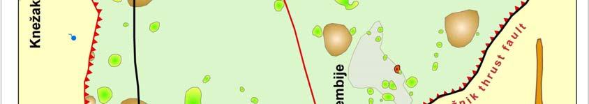
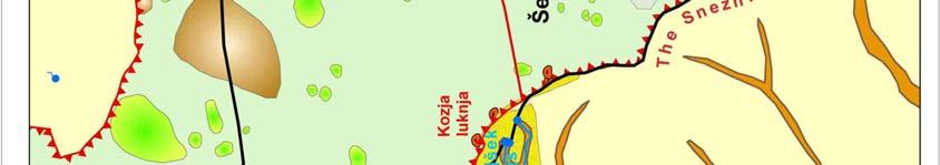
14 15 th International Karstological School Classical Karst, Postojna, Slovenia, HALF-DAY EXCURSION, 19 June 2007 HYDROGEOLOGICAL CHARACTERISATION AND VULNERABILITY MAPPING IN THE PODSTENJŠEK CATCHMENT Nataša Ravbar Karst Research Institute SRC SASA, Titov trg 2, SI-6230 Postojna, Slovenia. The Podstenjšek karst springs Karst springs of the Podstenjšek are situated near the Šembije village under the Snežnik mountain in south-western Slovenia. Karst water outflows in five permanent springs. At high waters numerous smaller springs are activated also. At times of extremely high water conditions water also bursts from the cave of Kozja luknja, which is situated 35 m above the springs. All the water joins in a common stream, called the Podstenjšek stream. After approximately three kilometres it flows into the Reka river as its right tributary. Since 1992 one of the springs has been captured for local drinking water supply. The Podstenjšek water source is not yet protected, even though the expert basis for the water source protection and the proposal of the decree on water protection zones have already been made. Geological and hydrological settings of the catchment area and surroundings The catchment area of the Podstenjšek springs occupies moderately karstified limestone and limestone breccias of Cennomanian age and limestone of Palaeocene age that are overthrusted to the impermeable flysch layers of Eocene age. Limestone of Lower Cretaceous age, containing very high percentage of CaCO 3 (93-98%) but very poor in fossils, prevails. The underlying flysch layers consist of marl, clay and sandstone (Šikić et al. 1972, Šikić & Pleničar 1975). In the uplifted dry valley at the outskirts of the catchment there is periglacial material deposited in the dolines (Fig. 1). Due to the underlying impermeable rocks a shallow karst aquifer is formed. In response to precipitation events or snowmelt fast and strong hydrologic variations of groundwater table appear, whereas it fluctuates for several tens of meters. There is no permanent surface stream recharging the springs, however, owing to groundwater fluctuations and weak connections between different karst conduits, two intermittent lakes appear whenever groundwater level is sufficiently high. However, these lakes appear very rarely the Šembijsko Jezero appears approximately once every two years, while the appearance of the Nariče has only been recorded twice in years 1929 and 2000 (Kovačič & Habič 2005). Shallow chromic Cambisol that is interwoven with Rendzina layers is unevenly spread and appears in patches. The thickest layers of soils can be found in the bottom of the concave relief shapes, while the rest of the surface is pretty rocky. Larger area is mainly overgrown with forest and meadows or is used for extensive pasturing. Precipitation is distributed relatively equally throughout the year, and practically no month is climatically dry. The amount of the precipitation in the studied area ranges between 1,500 and 1,600 mm per year, however, the amount increases towards the east due to the orographic barrier.
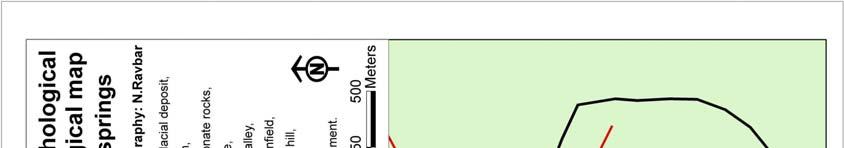
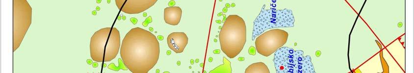
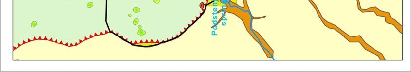
15 15 th International Karstological School Classical Karst, Postojna, Slovenia, Figure 1: Detail structural-lithological and geomorphological map of the Podstenjšek springs catchment area and surroundings.
16 15 th International Karstological School Classical Karst, Postojna, Slovenia, Hydrological characteristics of the Podstenjšek springs The springs demonstrate typical karst hydrological regime with very high short-term flow rates and prolonged periods of medium and low waters. The lowest observed discharge was 6 l/s and the highest was 1.6 m 3 /s. The average discharge is about 140 l/s. The ratio between low, medium and high waters is thus approximately 1:26:267, which is one of the highest ratios recorded among Slovene springs. In contrast, the springs do not show high water temperature variations. Water temperature ranges between 9 and 10.6 C in the same period. According to the almost constant water temperature being almost identical to the mean annual air temperature of the area (9.6 C) we can deduce to longer residence times for the underground water. Specific electrical conductivity ranges between 366 and 487 µs/cm. In general, rapid changes of discharge are followed by distinctive changes of conductivity and smaller but noticeable changes in water temperature, which also reflects the significant karst character of the Podstenjšek springs. The springs have torrential properties and are characterised by extremely fast reactions to hydrological events the extreme peaks of the discharges appear within a short time after excessive precipitation events. Usually the discharges of the Podstenjšek springs start to increase with a delay of just few hours or even less. However, some reactions of the springs to the intensive recharge show an interesting and peculiar positive correlation between the discharge and electrical conductivity values (Fig. 2). Figure 2: Hydrograph of the Podstenjšek springs in the period between 25 th November and 15 th December 2005 supplemented by precipitation data gained from the Slovene Environmental Agency (MOP ARSO 2007). Half hour values are displayed on the graph.

.")

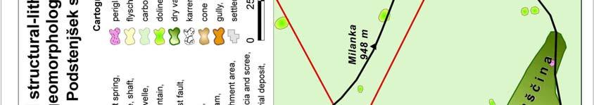
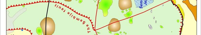
17 15 th International Karstological School Classical Karst, Postojna, Slovenia, Such behaviour could indicate the variations of the catchment size and contribution of other parts of the aquifer. When groundwater level in the Javorniki-Snežnik aquifer is sufficiently high the Podstenjšek becomes an overflow spring and its catchment boundary expands towards the north, northeast and east. Parts of the aquifer with higher groundwater electrical conductivity values (from the Javorniki and Pivka valley and/or from the Milanka mountain) are then also drained by the Podstenjšek (Fig. 3). In addition to larger recharge quantities, greater catchment area also explains very high discharge variations of the Podstenjšek (Ravbar 2007). Figure 3: Variable drainage divide during low and high water conditions. Slovene Approach to groundwater vulnerability and contamination risk mapping The Slovene Approach is based on the Spanish COP method of intrinsic vulnerability assessment (Vías et al. 2002, Andreo et al. 2006), which presented the most complete interpretation of the COST 620 methodology. However, the method has been substantially modified, complemented and extended for source vulnerability mapping. The proposed approach offers a new possibility to integrate surface and groundwater protection. Furthermore, temporal hydrological variability has been integrated in the concept of vulnerability mapping for the first time (Ravbar & Goldscheider 2006). The Slovene Approach also provides comprehensive risk analyses based on the assessment of intrinsic vulnerability, contamination hazard and the importance of the source or resource (Fig. 4).


18 15 th International Karstological School Classical Karst, Postojna, Slovenia, Figure 4: Assessment scheme for the intrinsic vulnerability and contamination risk mapping proposed according to Slovene Approach.
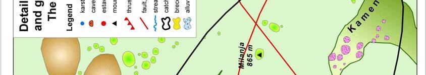
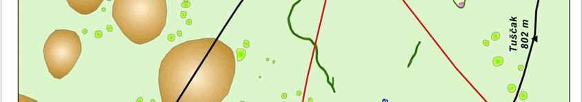
19 15 th International Karstological School Classical Karst, Postojna, Slovenia, Application to the Podstenjšek springs catchment and validation of the results For the catchment delineation and application of the Slovene Approach, a holistic research of the test site has been done, including tracer tests, detail structural-lithological and geomorphological mapping, electrical resistivity imaging, as well as hazard mapping. Continuous monitoring of the springs physico-chemical characteristics has been performed for the hydrograph analyses, water balance calculation and aquifer behavior comprehension (Ravbar 2007). The catchment can be subdivided into an inner and an outer zone. In the area that is always, directly and fully contributing to the discharge of the springs (i.e. the inner zone) the geomorphological features (karren, highly fractured areas, caves, karst edge) and outcrops along the roads where soil cover is absent or rarely exceeds 20 cm are identified as highly vulnerable. High degree of vulnerability is also assigned to the estavelle (shown in the zoomed inset) where occasional indirect infiltration occurs. Moderate vulnerability has been assigned to the bare karst landscape or karst covered by shallow soils, as well as to the karren and dry valleys in the area of the partial or occasional contribution to the springs (i.e. the outer zone). Bottoms of intermittent lakes and dolines covered by thicker soils or sediments are of low vulnerability, as well as rest of the area of the partial and/or occasional contribution. The hazards found in the test site are mainly classified as low or very low, however, in more than half of the area no hazards have been identified. In the Šembije village, the only settlement in the catchment, there are 209 inhabitants. The houses are linked to the public sewage system since 1998 and connected to the wastewater treatment plant. The intensity of agricultural activity is relatively low. However, there are some waste disposal and excavation sites. The importance of the source has been evaluated as medium. By superimposing source vulnerability, hazard and source importance maps, the total contamination risk has been obtained. In general, the contamination risk strongly depends on the hazard level and its distribution. Most of the catchment is exposed to low risk, only urban areas, roads, dumps and excavation sites represent medium degree of contamination risk (Fig. 5). The source vulnerability map shows zones of low, medium and high degree of vulnerability, which can be the basis for the protection zoning. However, vulnerability maps are conservative simplifications of natural conditions, therefore the results need to be validated. By carrying out two multi-tracer tests we examined and verified the adequacy of vulnerability class distribution and gained additional information on the mechanism of the potential contaminant transport in different hydrological conditions. The first experiment, carried out in March 2006, was made under high water conditions and was followed by several intense precipitation events so that immediate infiltration and transport of tracers towards the springs took place. Two tracers were injected (injection points A and B). The second experiment, carried out in November 2006, was made under low water conditions. Not until 15 days after the injection a more efficacious rain event occurred. Four tracers were injected in four locations (injection sites 1-4, Fig. 5). The validation with tracer tests confirmed that the Slovene Approach for intrinsic vulnerability assessment delivers plausible results. Furthermore, the validation also justifies the integration of hydrological variability into vulnerability mapping. The study has shown the new Slovene Approach gives justified results. Thus, it could be proposed as the basis for the delineation of karst source protection zones, and included to the state protection schemes. Although the method considers karst-specific infiltration conditions, it is not restricted solely to karst but can also be used in non-karst areas. Moreover, since we believe that vulnerability methods should not be restricted to the individual countries


20 15 th International Karstological School Classical Karst, Postojna, Slovenia, borders, the Slovene Approach could be a basis for the further work concerning groundwater protection elsewhere. Figure 5: Source vulnerability, hazard and total risk map of the Podstenjšek water source including validation results.
21 15 th International Karstological School Classical Karst, Postojna, Slovenia, References Andreo, B., Goldscheider, N., Vadillo, I., Vías, J.M., Neukum, Ch., Sinreich, M., Jiménez, P., Brechenmacher, J., Carrasco, F., Hötzl, H., Perles, J.M. & F. Zwahlen, 2006: Karst groundwater protection: First application of a Pan-European Approach to vulnerability, hazard and risk mapping in the Sierra de Líbar (Southern Spain).- Science of the Total Environment, 357, Kovačič, G., Habič, Š., 2005: Karst periodical lakes of Pivka (SW Slovenia) during high waters in November Acta Carsologica, 34, 3, , Ljubljana. MOP ARSO, 2007: Daily and annual precipitation data, Ilirska Bistrica, Ministry of the Environment and Spatial Planning, Environmental Agency (unpublished). Ravbar, N. & Goldscheider, N., 2006: Integrating temporal hydrologic variations into karst groundwater vulnerability mapping examples from Slovenia.- 8 th Conference on Limestone Hydrogeology, , Neuchâtel. Ravbar, N., 2007: Vulnerability and risk mapping for the protection of karst waters in Slovenia. Application to the catchment of the Podstenjšek springs.- PhD Thesis. Nova Gorica, University of Nova Gorica, Graduate School. 243 p. Šikić, D. & Pleničar, M., 1975: Osnovna geološka karta Jugoslavije. Tolmač za list Ilirska Bistrica.- Zvezni geološki zavod Beograd, 51 p., Beograd. Šikić, D., Pleničar, M., Šparica, M., 1972: Osnovna geološka karta SFRJ 1: , list Ilirska Districa, Zvezni geološki zavod Beograd. Vías, J.M., Andreo, B., Perles, J.M., Carrasco, F., Vadillo, I. & Jiménez, P., 2002: Preliminary proposal of a method for contamination vulnerability mapping in carbonate aquifer.- In: Karst and Environment. Carrasco, F., Durán, J.J. & Andreo, B. (Eds.). Málaga, Fundación Cueva de Nerja, Zwahlen, F., 2004: Vulnerability and Risk Mapping for the Protection of Carbonate (Karstic) Aquifers. Final report COST action European Commission, Directorate-General for Research, 297 p., Brüssel, Luxemburg.
22 15 th International Karstological School Classical Karst, Postojna, Slovenia, WHOLE-DAY EXCURSION, 21 June 2007 MANAGEMENT OF KARST AQUIFERS IN THE AREA BETWEEN TRIESTE AND KVARNER BAYS (Slovenian-Croatian transboundary area) Metka Petrič 1, Josip Rubinić 2, Nataša Ravbar 1, Janja Kogovšek 1, 1 Karst Research Institute SRC SASA, Titov trg 2, SI-6230 Postojna, Slovenia. 2 Faculty of Civil Engineering, University of Rijeka, Viktora Cara Emina 5, Rijeka, Croatia. Transboundary karst aquifers in the area between Trieste and Kvarner bays Slovenia is a typical karst country in which carbonate rocks cover around 43 % of the land. Karst water resources are especially important as they supply around half of the Slovene citizens with drinking water. Therefore the researches of karst waters have been an important task in the past and are becoming more and more important also for the future. The main question is how to use and protect karst water resources properly. To be efficient in this it is necessary to consider specific characteristics of karst aquifers. Due to their heterogeneous structure and complex functioning (unknown routes of the underground flow, bifurcation, the changes in the size of the recharge area at different hydrological conditions, ) it is by no means an easy task to identify these characteristics. One of the biggest problems is how to define the borders of the recharge area of individual karst springs. And scientific problem becomes also political when these recharge areas spread across two or more countries. In the south-western part Slovenia borders on two countries: Italy and Croatia. In the area between the Trieste bay and the Kvarner bay of the Adriatic sea state borders cross karst aquifers which are important sources of drinking water in all three countries. The biggest towns in the area are supplied by groundwater from these aquifers (e.g. Koper and other towns on the Slovene Coast from the Rižana karst spring, Rijeka in Croatia from several karst springs, among them also Riječina and Zvir, Buzet in Croatia from Sv. Ivan spring). One exception is Trieste in Italy. In the past the Timava karst spring was captured for the water supply of this town but due to the deterioration of its quality new sources were found in porous aquifers of the Soča/Isonzo alluvium. Common characteristic of mentioned karst springs is their transboundary character. At least partly their recharge area is in one country and abstraction point in the other. Therefore mutual and transboundary research activities and further management measures are indispensable. In the past first steps in this direction were made through different forms of scientific co-operation between research institutions from different countries, and on legal and institutional levels further activities are enhanced by the recommendations of the EU Water Framework Directive. Hydrogeological characteristics In a geotectonic sense the area between Trieste and Kvarner bays is in the boundary area between External Dinarides and Adriatic foreland (Placer 1999). The structure of thrust sheets with the alternation of Upper Cretaceous and Palaeocene carbonate rocks and Eocene flysch is characteristic. In well permeable limestones karst aquifers with dominant underground water flow are developed, and for flysch areas with very low permeability surface drainage net is


23 15 th International Karstological School Classical Karst, Postojna, Slovenia, characteristic. Hydrogeologically important are areas on the contacts between these two units where karst groundwater outflows through karst springs or surface streams from flysch sink into karst aquifers through ponors. Figure 6: Hydrogeological map of the area between Trieste and Kvarner bays of the Adriatic sea (Legend: 1. Karst-fissured aquifer, 2. Porous aquifer, 3. Very low permeable rocks, 4. Karst spring, 5. Surface stream, 6. Location of oil spillage, 7. Main, secondary and uncertain underground water connection, 8. State border (Sources of digital data: Geological Survey of Slovenija, EIONET ) The Reka river springs in the area of Eocene flysch near Zabiče village. It flows on the surface towards the contact with Cretaceous and Palaeocene limestone where it sinks underground into the world famous Škocjanske jame Caves and flows through the karst aquifer of Kras towards the springs in Trieste bay. The catchment area upstream the ponor is combined of surface drainage on Eocene flysch of the Brkini area and karst aquifer of the southern part of the Snežnik mountain (mostly Cretaceous limestone, partly also Palaeocene limestone). In the total area of around 350 km 2 around 28 % is karstic. Karst water emerges through several karst springs, the most important among them are Bistrica and Podstenjšek springs near Ilirska Bistrica. Additional inflows are numerous surface tributaries from flysch areas on both river banks. The discharges of the Reka river in this upper part range between 0.18 and 305 m 3 /s, with the mean discharge of 8.26 m 3 /s (Kolbezen & Pristov 1998). The hills of Brkini represent a surface watershed between the Reka river and the Rižana spring. The recharge area of the Rižana spring covers the surface of 245 km 2 and is predominantly karstic, but also sinking streams from the flysch of the southern edge of Brkini
24 15 th International Karstological School Classical Karst, Postojna, Slovenia, flow underground towards it. At this edge Eocene flysch is in the contact with Cretaceous and Palaeocene limestones of the Matarsko podolje and Podgora. Several small surface streams from the flysch sink underground and additionally recharge the karst aquifer. The main outflow of the karst aquifer is the Rižana spring, which is situated on the contact with very low permeable flysch rocks. The discharges of the Rižana spring range between 0.03 and 91 m 3 /s, and the mean discharge is 4.3 m 3 /s (Kolbezen & Pristov 1998). The Rižana river flows further on the flysch surface towards the Adriatic sea. The same karst aquifer recharges also the springs of Osapska Reka, as well as the Boljunec spring in Italy. And by tracer tests also groundwater flow towards the springs in Croatia (e.g. Mlini, Bulaž, Sv. Ivan, springs near Opatija) was proved. Proved underground water connections Detailed study of the Rižana catchment with three series of combined tracer tests was performed in the years from 1985 to 1987 (Krivic et al. 1987, Krivic et al. 1989). Tracings of sinking streams near Gračišče (rhodamine) and Smokovska vala (bacteriophages) in karst area southern of the Rižana spring, and near Brezovica (uranine) and Male Loče (KCl) in the north-western part of Brkini area (Figs. 6 and 7) were carried out in April Although several springs in the broader area on Slovenian and Croatian side of the border were sampled, tracers were detected only in the Rižana spring. Apparent velocity of groundwater flow from Brezovica was 104 m/h, from Gračišče 18 m/h, and from Smokovska vala 11 m/h. Concentrations of the potassium chloride were around the detection limit, so for the sinking stream in Male Loče no reliable connection was confirmed. At combined tracer test performed in May 1986 in the Brkini area rhodamine injected into the sinking stream in the Jezerina blind valley and bacteriophages injected into the sinking stram near Hotična appeared at the Rižana spring with the apparent velocities of 26 and 30 m/h. Rhodamine as well as uranine injected into the sinking stream at Male Loče were detected also at the Osapska Reka with the velocities of 30 and 33 m/h. Based on the results and detected increased concentrations of tracers also connections of the sinking streams in Jezerina and Male Loče with the springs Mlini and Sv. Ivan, as well as the springs near Opatija are possible. Uranine injected in May 1987 into the Račice in the Brkini area and rhodamine injected in Dane in the Čičarija region in Croatia were detected in the springs near Opatija only with apparent flow velocities of 40 and 88 m/h respectively. Bacteriophages from the Movraž in the karst area south-eastern from the Rižana spring reappeared at Mlini and Bulaž springs with velocities of 18 m/h and 50 m/h. In March 2001 a small sinking stream of the Beka-Ocizla Cave system south-western from Kozina was traced with uranine (Kogovšek & Petrič 2004). Main underground water connection with apparent flow velocity 33 m/h towards the Boljunec spring in Italy was proved. Only a weak connection with the Rižana spring was indicated (recovered 2 % of the injected tracer). Several tracer tests were performed also in the Croatian part of the recharge area of karst springs Bulaž and Sv. Ivan in order to define borders of their catchments. Contact karst of the Matarsko podolje and the Hotična blind valley Flysch Brkini hills are in their south-western side in the contact with karst area of Matarsko podolje, which is built of Palaeocene and Cretaceous limestones (Figs. 6 and 7). On 20 km
25 15 th International Karstological School Classical Karst, Postojna, Slovenia, long contact, in which carbonate rocks dip steeply below the flysch, surface waters from flysch sink underground into karst aquifer. Characteristic karst feature of this area are blind valleys with corrosion widened bottoms. Altogether 17 small surface streams drain the area of around 30 km 2. Catchments of individual sinking streams vary from 0.5 to 13.2 km 2. The altitudes of ponors are between 490 and 510 m a.s.l. Some ponors continue in the karst caves ending by the siphons of captured water in the altitudes between 370 and 430 m a.s.l. The deepest cave is 150 m deep, and the longest is 6 km long (Mihevc 1994) Several tracer tests, described in previous chapter, were performed in the area in order to define the directions of groundwater flow of these sinking streams. From the north-western part waters are flowing mainly towards the springs of Rižana and Osapska Reka, and from the south-eastern part towards the springs in the Kvarner bay in Croatia. The waters from ponors in between can flow in either direction, and also towards some inland karst springs in the catchment of the Mirna river (Fig. 6). Hotična is one of smaller blind valleys at the southern edge of the Brkini hills. Surface stream from flysch sinks into karst underground through the Hotiške ponikve Cave, which is 362 m long and 144 m deep. Entrance is in a rocky wall which closes the blind valley. In first 15 m the cave is horizontal, then it continues with several sections of vertical or inclined shafts, and it ends in a siphon lake. Figure 7: Contact karst at the southern edge of Brkini hills (Gams 2003). Rižana karst spring as an important source of drinking water The Rižana karst spring is situated at the contact of the karst aquifer and flysch at an altitude of 70 m a.s.l (Fig. 8). Its discharges range from 0.03 to 91 m 3 /s, and the mean discharge is 4.3 m 3 /s (Kolbezen & Pristov 1998). The recharge area of 245 km 2 (Krivic et al. 1987) is composed of thrust sheets involving an alternation of Upper Cretaceous and Palaeocene


26 15 th International Karstological School Classical Karst, Postojna, Slovenia, limestones and Eocene flysch. The largest part of the area is karstic, but the spring is also recharged from the ponors of the Brkini flysch area. A transboundary character of the catchment is indicated by the fact that 17 km 2 of it spreads on the Croatian territory. Figure 8: The Rižana karst spring (Photo: N. Ravbar). Water from the Rižana river has already been used in the early 19 th century, when Rižana valley has still been the granary of Trieste. In 1935 coastal water supply system was built. Rižana spring was captured and supplied all bigger cities at coast. Development of the coastal area and increasing consumption of drinking water dictated spread of the water supply system. Average annual quantity of water pumped from Rižana in the past few years is 192 l/s. Since 1965 water near Sečovlje with a common capacity of 100 l/s was pumped also. In 2001 this source was abandoned. Since 1970 subsequent 150 l/s of water from Gradole spring in Croatia, which is maintained by Istria water supply, is captured. Connection to Kras water supply built in 1994 offers up to 200 l/s of water, when needed. Since 1994 more than 99 percent of the population in the studied area is connected to the public water supply, among which the cities of Koper, Izola and Piran have been completely supplied. Out of tourist season 80,000 people and during the season more than 120,000 people are supplied. Joint quantity of consumed water in households is 3.9 millions m 3, while joint quantity of consumed water in economics is 2.15 millions m 3 water per year. The biggest consumers of water in the coastal area are port Luka Koper, that uses 150,000 m 3 water per year, hotels, health resort, food, car and other industry (Ravbar 2003). Water at the Rižana spring is not suitable for drinking before proper treatment. Therefore in the water plant nearby a process of ultrafiltration is used. It is a physical procedure and chemical substances are used only for the cleaning of membranes. With ultrafiltration suspended matter and all particles larger than 0.01 micron are removed from water (turbidity, organic macromolecules, microorganisms) and after treatment water is suitable for drinking. Protection of the Rižana spring Four protection zones in the recharge area of the Rižana spring (Fig. 9) were defined based on detailed geological and hydrogeological research, as well as three combined tracer tests


27 15 th International Karstological School Classical Karst, Postojna, Slovenia, (Krivic et al. 1989). In 1988 a Decree on protection zones of the Rižana spring and measures for water protection was issued. Problem is that this Decree was legally accepted only by the Municipality of Koper, which covers one third of the recharge area. Due to the conflicting interests in land use planning the rest is not legally protected. Difficulties in drinking water of the Coastal region are mainly in a serious ecological hazard of the existing water sources. Apparent velocity of groundwater in the Rižana spring hinterland depends on hydrological situation and directions of underground streams, but still it was proved, that it ranges between 11 to 520 m/h (Krivic et al. 1987). Even though an influential area and protection zones of the Rižana karst spring are defined, Koper-Hrpelje- Kozina railway still passes the first protection zone, in immediate vicinity of the spring. Some other local, regional and main roads and trails pass the second protection zone and eventual traffic accident could cause strong contamination of the Rižana and some other nearby springs. Illegal dumps could strongly burden karst water as well. Waste water that leaks out, flow directly into karst, into drinking water storage. Šebenik reports, that in 1994, when removal of waste was organized only in Kozina and its surrounding, there were still 18 illegal dumps with average volume of 36 m 3 in Matarsko podolje and 14 illegal dumps with average volume of 7 m 3 in Podgorski kras, which is in the Rižana springs immediate vicinity (Šebenik 1994). Figure 9: Protection zones of the Rižana, Sv. Ivan and Bulaž springs (Source of digital data: EIONET, Građevinski fakultet Rijeka). Sv. Ivan karst spring The Sv. Ivan karst spring is located in the valley of the upper part of Rijeka flow. Water outflows from limestone and flowing through impermeable flysch and Quaternary clay emerges at the surface at the altitude of 47 m a.s.l. (Figs. 10 and 11). Toatl capacity of the spring ranges between 0.13 and 2.15 m 3 /s, and mean discharge is m 3 /s (Rubinić et al. 2006). Due to a limited capacity of outflow at the main spring of Sv. Ivan, the overflow at


28 15 th International Karstological School Classical Karst, Postojna, Slovenia, high waters is through an intermittent spring Tombazin, which is located approximately 1 km south-eastern. The Sv. Ivan spring was captured for the water supply in 1933, and it is the first bigger karst spring connected to the Istria regional water supply system. The mean quantity of pumping is m 3 /s, and additional to the main spring also some smaller springs are included. Protection zones were defined based on tracer tests and hydrological analyses. Apparent flow velocities are relatively high and they range between 11 and 400 m/h. Based on performed hydrological studies (Bonacci & Magdalenić 1993) the extent of the potential (fictive) catchment of the spring is 60 km 2. But due to the complex nature of recharge and discharge of the Sv. Ivan spring, and considering the needs to protect the whole area, it was decided within the programme of the protection of drinking water resources in the region of Istarska županija, the total protected area is 103 km 2. To this area also smaller part of the total of 146 km 2 of common recharge zone of the sources of Opatija is added. It partly spreads on the Slovenian territory and has therefore a transboundary character. Figure 10: Hydrogeological profile of the Sv. Ivan spring (Legend: 1-Quaternary clays, 2- Flysch layers, 3-Karstified limestones, 4-Exploration borehole, 5-Capping bell; 6-Intermittent springs (Source: Hidroprojekt-ing 2000). Figure 11: Karst spring Sv.Ivan. The spring is still one of the most important sources of drinking water in the Istria region. Its biggest problem is frequent appearance of extremely high turbidity with maximum values of up to 2000 NTU. It is caused by important share of surface recharge from flysch areas during high waters, as well as fast flow and transport of matter through the karst aquifer. Suspended
29 15 th International Karstological School Classical Karst, Postojna, Slovenia, particles are also carriers of physico-chemical and bacteriological pollutants (Mihalić et al 2006). Bulaž karst spring The Bulaž spring is located at the beginning of the wide middle part of the Mirna river at the edge of the anticline of northern Istria, which cuts several flysch surface streams of the Zrenj plateau. It is a typical karst spring, situated at the edge of the valley at the contact of Cretaceous limestone and Quaternary sediments (Fig. 12). At the surface it has a shape of a lake or water eye with the diameter of 50 m and the altitude of outflow of 15 m a.s.l.. Maximal depth of the spring is 25 m, which is 10 m below sea level. In the lake water from the extensive karst catchment outflows through 3 channels. Figure 12: Detailed hydrogeological profile of the Bulaž spring (1-Water level at the spring, 2-Level of aquifer top, 3-Limestone, 4-Clay, 5-Breccia, 6-Fault, 8-Caverns, 9-Fissures, 10- Exploration borehole) (Source: RGN fakultet 1989). According to the perform studies (RGN fakultet 1984) the area of the Bulaž catchment is 105 km 2, of which 62 km 2 is on karst and 43 km 2 on flysch. Several small surface streams from the Zrenj plateau (with individual recharge areas from several km 2 to 11.5 km 2 ) ends their flow in ponors at the contact with limestone and in this way recharge the Gradole spring. A part of these streams has upper parts of the streams in Slovenia, therefore protection zones extend across the border. In 1987 a tracer test was performed with the injection into the ponor near Movraž (Krivic et al. 1989). Obtained concentrations of tracer in the Bulaž spring were around the detection limit, so the connection, although uncertain, can be defined. These results indicate more complex hydrological characteristics of this area and the possible existence of distant underground water connections which also cross the state borders in the broader observed area. The overflow capacity of the Bulaž spring has a wide range between and 38 m 3 /s, and the average is 2 m 3 /s. Since 1985, and especially since 1988 (when new capture system was built) the Bulaž spring has been a reserve source of the Istria water supply system. At present only low quantities of water are pumped (in average 8 l/s), but during drought they can increase in short periods also to 160 l/s. The pumping station is activated only during longer

30 15 th International Karstological School Classical Karst, Postojna, Slovenia, dry summer periods (not every year) in the way that pumped water is transported directly into the water supply system or through the pipeline to the capture of the Gradole spring in the lower part of the Mirna valley, where they are also properly treated. Figure 13: The Bulaž spring. Traffic accidents with spillage of hydrocarbons Due to the car accident near Kozina 18 tons of petroleum and fuel oil flew into karst in October 1993 (Knez et al. 1994). Several springs in the area of influence were monitored, but no concentrations above allowed values were detected. Rižana Mlini Os.Reka Sv. Ivan Rain Q-Rižana Concentration of mineral oils (µg/l), rain (mm) spillage , Q (m 3 /s) Figure 14: Measured concentrations of mineral oils in karst springs after the spillage in a traffic accident near Obrov in October But contamination of the Rižana spring was actually experienced in October 1994 after a spillage of 16 m 3 of gas oil in a traffic accident on a road near Obrov within the second protection zone (Kogovšek 1995). Also the springs of Osapska Reka, as well as Mlini and Sv. Ivan in Croatia (Vlahović 2000) were polluted. Due to the contamination with gas oil (up to 80 µg/l) the Rižana spring had to be taken out of use as a water-supply. Gas oil appeared after
31 15 th International Karstological School Classical Karst, Postojna, Slovenia, precipitation (Fig. 11), and the transport velocity was 45 m/h. Based on previous experience we can infer that the gas oil was discharging over a lengthy period after every precipitation event. At that time the water was treated with chlorine gas, which also resulted in the formation of carcinogenic derivatives. This was one of the reasons for changing the water treatment method for the Rižana water-supply system to that of ultra-filtration. References Bonacci, O., Magdalenić, A. 1993: The catchment area of the Sv. Ivan karst spring in Istria (Croatia).- Ground Water, 31/5; Hidroprojekt-ing, 2000: ''Vodoopskrbni sustav Istre Idejno rješenje sustava izvorišta vode u regionalnom prostoru. Unpublished, Zagreb. Mihalić, I., Kalanj, M., Rubinić, J., Nemarnik, M., Černeha Hajduk, B., Zorko, S., 2006: Analiza pojava mutnoća voda izvorišta istarskog vodovoda - podloga za projektiranje i operativan rad uređaja za kondicioniranje pitkih voda. In: Suvremene tehnologije i uređaji za pročišćavanje pitkih i otpadnih voda; Iskustva u izgradnji, pogonu i održavanju., Hrvatska grupacija vodovoda i kanalizacija, 61-69, Rijeka. Rubinić, J., Kogovšek, J., Diković, S., Petrič, M., Hrvojić, E., Knez, M., Slabe, T. 2006: Vode gornjeg i srednjeg toka rijeke Mirne. Hrvatske vode,14/54, Gams, I., 2003: Kras v Sloveniji v prostoru in času.- Založba ZRC, 516 pp, Ljubljana. Kogovšek, J., 1995: Izlitja nevarnih snovi ogrožajo kraško vodo. Onesnaženje Rižane oktobra 1994 zaradi izlitja plinskega olja ob prometni nesreči pri Obrovu.- Annales, 7, , Koper. Kogovšek, J., Petrič, M., 2004: Advantages of longer term tracing -- three case studies from Slovenia.- Environmental Geology, 47(1), Kolbezen, M., Pristov, J., 1998: Surface streams and water balance of Slovenia.- MOP: Hidrometeorološki zavod RS, 98 pp, Ljubljana. Knez, M., Kranjc, A., Otoničar, B., Slabe, T., Svetličič S., 1994: Posledice izlitja nafte pri Kozini.- Ujma, 8, 74-80, Ljubljana. Krivic, P., Bricelj, M., Trišič, N., Zupan, M., 1987: Sledenje podzemnih vod v zaledju Rižane.- Acta Carsologica, 16, , Ljubljana. Krivic, P., Bricelj, M., Zupan, M., 1989: Podzemne vodne zveze na področju Čičarije in osrednjega dela Istre (Slovenija, Hrvatska, NW Jugoslavija).- Acta Carsologica, 18, , Ljubljana. Mihevc, A., 1994: Contact karst of Brkini hills.- Acta carsologica, 23, , Ljubljana. Placer, L., 1999: Contribution to the macrotectonic subdivision of the border region between Southern Alps and External Dinarides.- Geologija, 41, , Ljubljana. Ravbar, N. 2003: Drinking water supply from karst water resources (The example of Koprsko primorje, SW Slovenia).- RMZ-mater. Geoenvironment, 50, 1, , Ljubljana. RGN fakultet, 1998: Zone sanitarne zaštite izvora Bulaž u Istri.. Unpublished, Zagreb. RGN fakultet, 1989: Hidrogeološka istraživanja izvora Bulaž u Istri.- Unpublished, Zagreb. Šebenik, I., 1994: Geografska presoja odlaganja odpadkov v nekaterih pokrajinskih tipih Slovenije.- Magistrsko delo. Ljubljana, Filozofska fakulteta Univerze v Ljubljani, Oddelek za geografijo, 161 str. Vlahović, T., 2000: Kemizam vode kao indikator regionalnog kretanja podzemne vode u krškim vodonosnicima: izvor Sv. Ivan, Istra.- Proceedings of 2. Croatian geological congress Cavtat-Dubrovnik , Zagreb.
32 15 th International Karstological School Classical Karst, Postojna, Slovenia, HALF-DAY EXCURSION, 22 June 2007 TRANSBOUNDARY KARST AQUIFER OF KRAS (Slovenian-Italian transboundary area) Metka Petrič 1, Borut Peric 2, Franci Gabrovšek 1, Nataša Ravbar 1, Janez Turk 1 1 Karst Research Institute SRC SASA, Titov trg 2, SI-6230 Postojna, Slovenia 2 Park Škocjanske jame Public Agency, Škocjan 2, SI-6215, Divača, Slovenia Hydrogeological characteristics of the Kras area Kras is a limestone plateau, lying above the Trieste bay (Fig. 15). It is 50 km long, up to 13 km wide and is stretching in NW SE direction. Hydrogeologicaly uniform karst aquifer is politically divided between two countries - Slovenia and Italy. The main part of the aquifer is in Slovenia, but the whole karst coast and the springs are in Italy. Figure 15: Hydrogeological map of the Kras area (Legend: 1. Cretaceous limestone, 2. Cretaceous dolomite, 3. Palaeocene limestone, 4. Porous aquifer, 5. Very low permeable Eocene flysch, 6. Timava spring, 7. Spring, 8. Pumping station, 9. Underground water connection, proved by tracer test, 10. Karst cave (a. Škocjanske jame, b. Kačna jama, c. Labodnica, d. Lazzaro Jerko, e. Gabranca, f. Jama 1 v Kanjaducah, g. Brezno v Stršinkni dolini,), 11. Sinking stream, 12. Surface flow, 13. State border, 14. Settlement). Kras belongs to Adriatic-Dinaric tectonic plate, to the region of Outer Dinarides. In the narrower sense it belongs to a smaller tectonic unit called the Trieste-Komen anticlinorium, which consists of several smaller anticlines and synclines with folds trending in the NW-SE (Dinaric) direction (Kranjc 1997). The most distinctive faults that cut this area in the Dinaric direction are the Raša fault which crosses the northern edge of Kras and the Divača fault in its central part. Position of the springs and caves with permanent water flow is connected with
33 15 th International Karstological School Classical Karst, Postojna, Slovenia, some smaller faults in the NE-SW direction, which influence the orientation of groundwater flow. Cretaceous and Tertiary carbonate deposits mainly of shallow, warm-water carbonate shelf environments are characteristic for the Kras area. The central part is built by well karstified and well permeable Cretaceous limestone and partly dolomite in the thickness of more than 1000 m (Fig. 15). Dolomite layers are slightly less permeable and may play, if they are thicker, a role of a relative isolator. To the north, south and east the Cretaceous carbonate rocks pass into bedded and tabular limestones of Palaeocene age, which are also fissured and karstified. The carbonate massif is surrounded by very low permeable Eocene flysch which acts as an important hydrogeological barrier. There where flysch is interrupted numerous springs in the Trieste bay of the Adriatic sea appear. In the north-western part the Kras aquifer is in contact with the porous aquifer of alluvial sediments deposited along surface streams of Soča and Vipava. The biggest among the springs are the Timava springs with discharges from 9.1 m 3 /s to 127 m 3 /s, and mean discharge 30.2 m 3 /s in the period (Civita et al. 1995). Three big submerged mouths are connected by a network of passages that reach a depth of about 80 m. The average water level is around 2.4 m above the sea level. They demonstrate typical karst hydrological regime with fast reactions on precipitation and sharp discharge peaks, and with longer periods of medium and low waters (Fig. 16). In the past Timava was captured for Trieste water supply, but due to the low quality of water other sources are now used. Several smaller springs are located further inland at the altitudes from 0.4 to 12 m above the sea level. Especially interesting are submarine springs along the coast between Timava springs and Trieste. The most important is the Brojnica near the village Nabrežina (Aurisina), which has been captured for the water supply since 1857, and then abandoned in Timava spring Reka sinking stream Discharge (m 3 /s) Date Figure 16: Discharges of the Reka sinking stream and the Timava spring in the year 2005/06 (Sources of data: Environmental Agency of the Republic of Slovenia, ACEGAS Trieste). The karst aquifer of Kras, which is drained through described springs, is recharged mainly by the primary infiltration of precipitation through well karstified surface. Average yearly precipitation on Kras vary from 1400 to 1650 mm, and average yearly evapotranspiration from 700 to 750 mm (Kolbezen & Pristov 1998). Very important source of recharge is also the Reka river which sinks into the Škocjanske jame Caves at south-eastern border of Kras (Fig. 15). As it was proved by numerous tracer tests (Timeus 1928, Mosetti 1965, Gemiti 1994) it reappears again in the springs of the Trieste bay.
34 15 th International Karstological School Classical Karst, Postojna, Slovenia, The Reka river gathers the water from the area of more than 350 km 2, mostly with surface drainage network on Eocene flysch. The rest is Mesozoic karst area, which is drained through 4 karst springs into the Reka surface stream. In the period the minimal measured discharge of the Reka river was 0.18 m 3 /s and the mean discharge 8.26 m 3 /s (Kolbezen & Pristov 1998). The length of the underground flow is about 41 km. The underground water of Reka river, between swallow hole and springs, is accessible in some deep caves only, such as Kačna jama, Jama 1 v Kanjaducah, Brezno v Štršinkni dolini, Labodnica (Grotta di Trebiciano) and Grotta Lazzaro Jerko. Additionally some other sinking streams from the surrounding area recharge the Kras aquifer (Fig. 15). Inflows from the rivers Soča, Vipava and Raša, and from some smaller streams out of the karst basin (Sajevče brook at the southern border of the Postojna basin, sinking streams near Dolenja Vas and Senožeče) were proved by tracing with environmental and artificial tracers (Timeus 1928, Bidovec 1967, Cancian 1987, Habič 1989, Habič 1990, Civita et al. 1995). Results of combined chemical and isotopic analysis confirmed important influence of the Soča river (Flora & Longinelli 1989, Urbanc & Kristan 1998). Water from the sand and gravel sediments in the Soča river basin enters into the karstified limestones of Kras along the long contact between both aquifers. Especially during longer periods without precipitation and low hydraulic pressures of the karst aquifer such inflow from the Soča basin effectively compensates insufficient primary recharge on Kras. Drinking water supply on the Kras plateau On the Slovene territory of Kras, there are no superficial streams and also there are no springs suitable to be captured. In recent decades the development of drilling technology provides the possibility of reaching the underground water several hundred meters deep. Water supply company Kraški Vodovod pumps up to 250 l/s of water from the boreholes near Klariči which have been connected to the Kras water supply system since Since 1994 the system has been linked with the system of Rižana water supply and thus the surplus pumped water may also be used to supply the Slovene Littoral. The biggest economic problem on the Kras plateau in the past used to be the drinking water supply, which has also been one of the reasons for the scarce settling of the Kras plateau. Today the Water Supply Company provides drinking water to households and industry on the Kras plateau and the quantity is sufficient to supply the coastal region in the summer months as well. Water supply is founded on effective karst groundwater pumping near Klariči. Some water is captured from karst springs under Nanos Mountain as well. The Water Supply Company supplies more than 22,500 inhabitants out of the tourist season. A basic question of drinking water supply on Kras plateau is how to assure a suitable water quality and quantity and how to reduce water losses in the supply network. Inadequate upkeep of the old pipelines causes damage and enormous losses of more and more valuable water. Therefore the Water Supply Company must invest more into maintenance and reconstruction of the system. Karst groundwater, which is pumped, is organically polluted due to its vast recharge area. It is also endangered by contamination because of unsuitable transport system and hazardous spills of dangerous substances in its catchment area and dumping in a direct recharge area. Water capacities of the source are not yet completely exploited though. In water supply planning in future, numerous other local water resources linked to traditional ways of water supply need to be considered. Eventual rainwater usage for garden irrigation or car washing, and purified wastewater usage for communal activity (street washing) or for the needs of farming and industry (as technological water) is not excluded.
.")
35 15 th International Karstological School Classical Karst, Postojna, Slovenia, Škocjanske jame Caves ponor of the Reka river At the end of the surface flow on flysch the Reka river flows on limestone through 4 km long gorge, which ends with the entrance into the famous Škocjanske jame Caves, which are enlisted in the UNESCO World Heritage (Kranjc 1997). Upstream from the cave are two big collapse dolines: Velika dolina (165 m deep) and Mala dolina (120 m deep), which are separated by a natural bridge as a remnant of a cave ceiling (Fig. 17). Above the Mala dolina at the top of a steep rocky wall the Škocjan village is situated. Near the village is 60 m deep Okroglica shaft, which reaches the underground Reka flow. In the bottom of Velika dolina the Reka river finally sinks underground at the altitude 317 m a.s.l., flows through the cave (water flow in the cave is 3.5 km long, length of all channels in the cave is 6.2 km) and emerges again in the springs of the Trieste bay. At extremely high waters underground channels are not able to swallow the inflowing water of the Reka river, which results in floods. The highest registered level of water in Velika dolina was 132 m above the siphon at the end of the cave (altitude 214 m). In the vicinity of the ponor there are several collapse dolines and blind valleys, which indicate changes of the location of flow in the past. Figure 17: Plan of the Škocjanske jame Caves (Drole 1999) The Reka river sinks underground also in the limestone riverbed upstream the main ponor. In 1982 a ponor (5x10 m big, 27 m deep) was formed due to a collapse in the riverbed and during low water conditions the total flow of Reka river was disappearing into this ponor. At present the ponor is filled with sediments, but still around 1 m 3 /s sinks underground through it and than further below the accessible galleries of the Škocjanske jame.
HYDROGEOLOGICAL RESEARCH OF THE CROATIAN PART OF THE TRANSBOUNDARY AQUIFERS (HR-SI) BETWEEN KVARNER BAY AND TRIESTE BAY
 BETWEEN KVARNER BAY AND TRIESTE BAY") Workshop on the protection of groundwater as a source of drinking water in karst areas April 14-15, 2008, Malinska - CROATIA HYDROGEOLOGICAL RESEARCH OF THE CROATIAN PART OF THE TRANSBOUNDARY AQUIFERS
Workshop on the protection of groundwater as a source of drinking water in karst areas April 14-15, 2008, Malinska - CROATIA HYDROGEOLOGICAL RESEARCH OF THE CROATIAN PART OF THE TRANSBOUNDARY AQUIFERS
Destruction of dolines: the examples from Slovene karst
 Destruction of dolines: the examples from Slovene karst dr. Gregor Kovačič (1) and dr. Nataša Ravbar (2) (1) University of Primorska, Faculty of humanities Koper, Science and Research Centre, Koper, Slovenia
The Isonzo/Soca river basin
 Geneva September 8 th 2014 The Isonzo/Soca river basin Status and perspective on the possible Alpine river basin to be assessed The Alpine Convention Water management, risk management and adaptation to
REPORT of the visit of eminent experts in karstоlogy Derek Ford and Petar Milanović to the Centre for Karst Hydrogeology
 REPORT of the visit of eminent experts in karstоlogy Derek Ford and Petar Milanović to the Centre for Karst Hydrogeology In honour of the Petar Milanović s 80 th birthday, Centre for Karst Hydrogeology
Seasonal Variability of the Groundwater Regime for Several Aquifers in Bulgaria Tatiana Orehova 1
 Seasonal Variability of the Groundwater Regime for Several Aquifers in Bulgaria Tatiana Orehova 1 The purpose of the paper is to analyse the seasonal variability of the groundwater regime for several aquifers
SUPPORT TO WATER RESOURCES MANAGEMENT IN THE DRINA RIVER BASIN DRAFT ROOF REPORT INTRODUCTION AND GENERAL APPROACH
 SUPPORT TO WATER RESOURCES MANAGEMENT IN THE DRINA RIVER BASIN DRAFT ROOF REPORT INTRODUCTION AND GENERAL APPROACH Nadja Zeleznik, REC Public Concultation Beograd, Serbia, 4 July 2017 1 1. Introduction
THE IMPLEMENTATION OF EWFD/WFD IN THE REGION OF VOJVODINA WITHIN JOINT SLOVAK-SERBIA SERBIA PROJECTS
 Towards Integrated River Basin Management The 55 th Anniversary of the Founding of the Water Research Institute THE IMPLEMENTATION OF EWFD/WFD IN THE REGION OF VOJVODINA WITHIN JOINT SLOVAK-SERBIA SERBIA
Hydrological study for the operation of Aposelemis reservoir Extended abstract
 Hydrological study for the operation of Aposelemis Extended abstract Scope and contents of the study The scope of the study was the analytic and systematic approach of the Aposelemis operation, based on
Geologia Croatica 63/ Figs. Zagreb
 63/2 187 193 7 Figs. Zagreb 2010 187 Observations of stage and temperature dynamics in the epiphreatic caves within the catchment area of the Ljubljanica River (Slovenia) Franci Gabrovšek and Janez Turk
Invitation to CROSS-BORDER DRINKING WATER MANAGEMENT. International Symposium: 29 th January Rijeka, Croatia
 Invitation to International Symposium: CROSS-BORDER DRINKING WATER MANAGEMENT 9 th January 06 Rijeka, Croatia Faculty of Civil Engineering University of Rijeka Radmile Matejčić 3 5000 Rijeka Croatia Rijeka,
MEASURING ACCESSIBILITY TO PASSENGER FLIGHTS IN EUROPE: TOWARDS HARMONISED INDICATORS AT THE REGIONAL LEVEL. Regional Focus.
 Regional Focus A series of short papers on regional research and indicators produced by the Directorate-General for Regional and Urban Policy 01/2013 SEPTEMBER 2013 MEASURING ACCESSIBILITY TO PASSENGER
43. DEVELOPMENT AND DISTRIBUTION OF TOURISM
 Tourism Tourism is one of the world s largest industries. In many regions it is also the greatest source of revenue and employment. Tourism demand is based on the values and needs of modern tourists, while
Caves of Mt. Miroč (Danube Gorge, Eastern Serbia)
") Caves of Mt. Miroč (Danube Gorge, Eastern Serbia) Vladimir LJUBOJEVIĆ Student Speleologic and Alpinistic Club (ASAK), Studentski trg 16, 11000 Belgrade, Yugoslavia fric@sezampro.yu Abstract Mt. Miroč is
Caves of Mt. Miroč (Danube Gorge, Eastern Serbia) Vladimir LJUBOJEVIĆ Student Speleologic and Alpinistic Club (ASAK), Studentski trg 16, 11000 Belgrade, Yugoslavia fric@sezampro.yu Abstract Mt. Miroč is
Ecohydrology of karst poljes and their vulnerability
 Ecohydrology of karst poljes and their vulnerability Prof. emeritus O. Bonacci Faculty of Civil Engineering, Architecture and Geodesy, Split University, 21000 Split, Matice hrvatske 15, Croatia E-mail:
Water resources cycle in karst (feasibility studies and engineering design; case studies)
") Water resources cycle in karst (feasibility studies and engineering design; case studies) Prof. emeritus Ognjen Bonacci Faculty of Civil Engineering, Architecture and Geodesy, Split University E-mail:
Water resources cycle in karst (feasibility studies and engineering design; case studies) Prof. emeritus Ognjen Bonacci Faculty of Civil Engineering, Architecture and Geodesy, Split University E-mail:
Blocking Sea Intrusion in Brackish Karstic Springs
 European Water 1/2: 17-23, 3. 3 E.W. Publications Blocking Sea Intrusion in Brackish Karstic Springs The Case of Almiros Spring at Heraklion Crete, Greece A. Maramathas, Z. Maroulis, D. Marinos-Kouris
Protection and Sustainable Use of the Dinaric Karst Transboundary Aquifer System
 Protection and Sustainable Use of the Dinaric Karst Transboundary Aquifer System Second Workshop "River Basin Commissions and Other Joint Bodies for Transboundary Water Cooperation: Technical Aspects "
The Timok River Basin in Serbia
 The Timok River Basin in Serbia UNECE Workshop on Integrated Transboundary Water Resources Management in SEE, Sarajevo, 18-20 May, 2009 Dragana Ninković, Dipl.-Ing. Dušan Dobričić, Dipl.-Ing. Content 1.
Post Congress excursions*:
 Post Congress excursions*: 1. Dubrovnik Ombla - Popovo polje (Vjetrenica) (BiH) HE Trebinje (BiH) Grahovsko polje (MNE) The Boka Kotorska Springs and Kotor Old town (UNESCO heritage site) (MNE) Dubrovnik
DETECTION OF WATER LEAKS IN FOUM EL-GHERZA DAM (ALGERIA)
") Ninth International Water Technology Conference, IWTC9 2005, Sharm El-Sheikh, Egypt 581 DETECTION OF WATER LEAKS IN FOUM EL-GHERZA DAM (ALGERIA) N. Hocini and A.S. Moulla Applied Hydrology and Sedimentology
Ninth International Water Technology Conference, IWTC9 2005, Sharm El-Sheikh, Egypt 581 DETECTION OF WATER LEAKS IN FOUM EL-GHERZA DAM (ALGERIA) N. Hocini and A.S. Moulla Applied Hydrology and Sedimentology
Extraordinary summer flood in a karst area: case study in Croatia
 The Extremes ofthe Extremes: Exlraordinan' Floods (Proceedings ol'a symposium held at Reykjavik. Iceland. July 2000). IAHS Publ. no. 271. 2002. 133 Extraordinary summer flood in a karst area: case study
Adriatic karstic estuaries, their characteristics and evolution
 Conférence Méditerranéenne Côtière et Maritime EDITION 4, SPLIT, CROATIA (2017) Coastal and Maritime Mediterranean Conference Disponible en ligne http://www.paralia.fr Available online Adriatic karstic
Silvia Giulietti ETIS Conference Brussels An EEA reporting mechanism on tourism and environment and ETIS
 Silvia Giulietti ETIS Conference Brussels 28.01.2016 An EEA reporting mechanism on tourism and environment and ETIS Main content Why tourism and environment? Why a reporting mechanism on tourism and environment
DriDanube. Drought Risk in the Danube Region. Department of Geodesy and Geoinformation (GEO) Vienna University of Technology (TU Wien)
 Vienna University of Technology (TU Wien)") DriDanube Drought Risk in the Danube Region Department of Geodesy and Geoinformation (GEO) Vienna University of Technology (TU Wien) Vienna, 4 April 2018 DriDanube Drought Risk in the Danube Region Project
DriDanube Drought Risk in the Danube Region Department of Geodesy and Geoinformation (GEO) Vienna University of Technology (TU Wien) Vienna, 4 April 2018 DriDanube Drought Risk in the Danube Region Project
Visit of Chinese representatives of the International Research Centre for Karst (IRCK) to the CKH
 to the CKH") Visit of Chinese representatives of the International Research Centre for Karst (IRCK) to the CKH The International Research Center on Karst (IRCK) was formed in 2008 in Guilin, China under the Auspices
Visit of Chinese representatives of the International Research Centre for Karst (IRCK) to the CKH The International Research Center on Karst (IRCK) was formed in 2008 in Guilin, China under the Auspices
J.M. Marques a, C. Matos b, P.M. Carreira c and M.O. Neves a
 GEOCHEMICAL AND ISOTOPIC TOOLS TO ASSESS CALDAS DA RAINHA THERMOMINERAL WATER SYSTEM ASCRIBED TO A KARST/FISSURED-POROUS ENVIRONMENT (PORTUGAL): A REVIEW J.M. Marques a, C. Matos b, P.M. Carreira c and
CO-OPERATION IN DANUBE RIVER BASIN - THE ROLE OF SHMI SLOVENSKÝ HYDROMETEOROLOGICKÝ ÚSTAV
 CO-OPERATION IN DANUBE RIVER BASIN - THE ROLE OF SHMI WMO RAVI Hydrological Forum 2016 Oslo, 1 Danube, the 2nd longest in Europe. 2857 km Flows across 10 European states River basin - 817 000 km2 1/11
If there is magic on this planet, it is contained in water.
 If there is magic on this planet, it is contained in water. Loren Eiseley ~ American philosopher and nature writer ~ b.1907 d.1977 Above: A swimmer rests in the X Keken Cenote underground pool in the town
HEATHROW COMMUNITY NOISE FORUM
 HEATHROW COMMUNITY NOISE FORUM 3Villages flight path analysis report January 216 1 Contents 1. Executive summary 2. Introduction 3. Evolution of traffic from 25 to 215 4. Easterly departures 5. Westerly
GRANDE News Letter Volume1, No.3, December 2012
 GRANDE News Letter Volume1, No.3, December 2012 Building a water management system in La Paz, Bolivia Climate change is a phenomenon that affects the entire world, but its impact on people differs depending
Breakthrough of the Tunnel with the Biggest Overburden in Croatia
 289 Breakthrough of the Tunnel with the Biggest Overburden in Croatia Redovnikovi, L., Ališi, I., and Džapo, M. University of Zagreb, Faculty of Geodesy, Fra Andrija Ka i a Mioši a 26, 1 Zagreb, Croatia,
ACTION PLAN FOR THE PERIOD concerning the STRATEGY ON IMPLEMENTATION OF THE FRAMEWORK AGREEMENT ON THE SAVA RIVER BASIN
 Doc. 1S-26-O-11-5/1-2 ACTION PLAN FOR THE PERIOD 2011-2015 concerning the STRATEGY ON IMPLEMENTATION OF THE FRAMEWORK AGREEMENT ON THE SAVA RIVER BASIN April 2011 Table of Contents INTRODUCTION... 5 1.
ARTIFICIAL RECHARGE OF THE UNDERGROUND KARSTIC AQUIFER OF FARSALA AREA (THESSALY, CENTRAL GREECE) 1
 1") ARTIFICIAL RECHARGE OF THE UNDERGROUND KARSTIC AQUIFER OF FARSALA AREA (THESSALY, CENTRAL GREECE) 1 MARIOLAKOS, I. 2, FOUNTOULIS, I., SPYRIDONOS, E., MARIOLAKOS, D., ANDREADAKIS, EM. ABSTRACT The area
ARTIFICIAL RECHARGE OF THE UNDERGROUND KARSTIC AQUIFER OF FARSALA AREA (THESSALY, CENTRAL GREECE) 1 MARIOLAKOS, I. 2, FOUNTOULIS, I., SPYRIDONOS, E., MARIOLAKOS, D., ANDREADAKIS, EM. ABSTRACT The area
Prof. Dr Željko Vaško Doc. Dr Tihomir Predić MSc Boris Marković
 First Interim Meeting of the Regional Expert Advisory Working Group on Areas with Natural Constrains Prof. Dr Željko Vaško Doc. Dr Tihomir Predić MSc Boris Marković 29 th June 01 th July, 2016 Andrevlje,
VISIT CENTRE OF KARST HYDROGEOLOGY MEMBERS TO THE IRCK do
 VISIT CENTRE OF KARST HYDROGEOLOGY MEMBERS TO THE IRCK 15. 10. do 31. 10. 2014 In the period from 15. 10. to 31. 10. 2014 year, members of the Center for Karst Hydrogeology, Dr. Sasa Milanovic and Ljiljana
The Impact of Human Activities on Dolines (Sinkholes) Typical Geomorphologic Features on Karst (Slovenia) and Possibilities of their Preservation
 Typical Geomorphologic Features on Karst (Slovenia) and Possibilities of their Preservation") ISSN 0354-8724 (hard copy) ISSN 1820-7138 (online) The Impact of Human Activities on Dolines (Sinkholes) Typical Geomorphologic Features on Karst (Slovenia) and Possibilities of their Preservation Cernatič-Gregorič
ISSN 0354-8724 (hard copy) ISSN 1820-7138 (online) The Impact of Human Activities on Dolines (Sinkholes) Typical Geomorphologic Features on Karst (Slovenia) and Possibilities of their Preservation Cernatič-Gregorič
Water resource situation of the Republic of Djibouti
 Water resource situation of the Republic of Djibouti Omar ASSOWE DABAR Integrating Groundwater Management within River Basins 15-17 January 2019 Nairobi, Kenya Regional Training Workshop on Introduction
GLACIER STUDIES OF THE McCALL GLACIER, ALASKA
 GLACIER STUDIES OF THE McCALL GLACIER, ALASKA T John E. Sater* HE McCall Glacier is a long thin body of ice shaped roughly like a crescent. Its overall length is approximately 8 km. and its average width
EL PASO S DESALINATION EFFORTS
 El Paso s Desalination Efforts WATER DESALINATION AND REUSE STRATEGIES FOR NEW MEXICO SEPTEMBER NEW MEXICO WATER RESOURCES RESEARCH INSTITUTE 2004 Bill Hutchison has more than 20 years of experience as
Shrubs and alpine meadows represent the only vegetation cover.
 Saldur river General description The study area is the upper Saldur basin (Eastern Italian Alps), whose elevations range from 2150 m a.s.l. (location of the main monitoring site, LSG) and 3738 m a.s.l.
 AGREEMENT Between Director of the Białowieża National Park, based in Białowieża (Poland) and Director of the National Park Bialowieża Forest, based in Kamieniuki (Belarus) and Head Forester of the Białowieża
Tectonic Lakes-Climatic and Anthropogenic Impacts
 European Geosciences Union General Assembly 2011 Vienna Austria 03-08 April 2011 Session: Lakes and Inland Seas Tectonic Lakes-Climatic and Anthropogenic Impacts Cvetanka Popovska University of Ss Cyril
City tourism: a successful product
 City tourism: a successful product Observation and analytical units. Tourist Destination Management (area 16) Inmaculada Gallego Galán and Ana Moniche Bermejo Department of Statistics and Market Research.
Visual and Sensory Aspect
 Updated All Wales LANDMAP Statistics 2017 Visual and Sensory Aspect Final Report for Natural Resources Wales February 2018 Tel: 029 2043 7841 Email: sw@whiteconsultants.co.uk Web: www.whiteconsultants.co.uk
International Sava River Basin Commission - An example of EU/non EU country cooperation in water management
 International Sava River Basin Commission - An example of EU/non EU country cooperation in water management Improvement and co-operation possibilities in the water sector with non-eu countries Ulm, 29
Intermediate report. Letter of agreement FAO - GCB/RAB/013/ITA
 Treated waste water for sustainable production of valuable biomass, soil and water quality improvement and combating desertification in Algeria and Tunisia Letter of agreement FAO - GCB/RAB/013/ITA Intermediate
Hydrology Input for West Souris River IWMP
 Hydrology Input for West Souris River IWMP Prepared by: Mark Lee Manitoba Water Stewardship 1 1 1 Overall view of: drainage area watershed characteristics gauging stations meteorological stations Runoff
The Potentially Dangerous Glacial Lakes
 Chapter 11 The Potentially Dangerous Glacial Lakes On the basis of actively retreating glaciers and other criteria, the potentially dangerous glacial lakes were identified using the spatial and attribute
EU GPP CRITERIA FOR INDOOR CLEANING SERVICES 1. INTRODUCTION
 EU GPP CRITERIA FOR INDOOR CLEANING SERVICES (please note that this document is a compilation of the criteria proposed in the 3 rd Technical Report, which should be consulted for a full understanding of
Coverage of Mangrove Ecosystem along Three Coastal Zones of Puerto Rico using IKONOS Sensor
 Coverage of Mangrove Ecosystem along Three Coastal Zones of Puerto Rico using IKONOS Sensor Jennifer Toledo Rivera Geology Department, University of Puerto Rico, Mayagüez Campus P.O. Box 9017 Mayagüez,
Project Data Sheet BASIC PROJECT DATA
 BASIC PROJECT DATA Full project title: Short project title: (acronym) Improvement of navigation in the joint Bulgarian-Romanian section of the Danube river from km 530 to km 520 Batin and from km 576 and
Hazards caused by natural and anthropogenic changes of catchment area in karst
 Natural Hazards and Earth System Sciences (004) 4: 655 66 SRef-ID: 684-998/nhess/004-4-655 European Geosciences Union 004 Natural Hazards and Earth System Sciences Hazards caused by natural and anthropogenic
9th INTERNATIONAL CONFERENCE AND EXHIBITION OIL & GAS < and primary energy >
 www.hunig.hr 9th INTERNATIONAL CONFERENCE AND EXHIBITION OIL & GAS < and primary energy > CROATIAN ASSOCIATION OF PETROLEUM ENGINEERS AND GEOLOGISTS 3 4 October 2017 Šibenik - Hotel Solaris 1st ANNOUNCEMENT
HEATHROW COMMUNITY NOISE FORUM. Sunninghill flight path analysis report February 2016
 HEATHROW COMMUNITY NOISE FORUM Sunninghill flight path analysis report February 2016 1 Contents 1. Executive summary 2. Introduction 3. Evolution of traffic from 2005 to 2015 4. Easterly departures 5.
Dr. Dimitris P. Drakoulis THE REGIONAL ORGANIZATION OF THE EASTERN ROMAN EMPIRE IN THE EARLY BYZANTINE PERIOD (4TH-6TH CENTURY A.D.
 Dr. Dimitris P. Drakoulis THE REGIONAL ORGANIZATION OF THE EASTERN ROMAN EMPIRE IN THE EARLY BYZANTINE PERIOD (4TH-6TH CENTURY A.D.) ENGLISH SUMMARY The purpose of this doctoral dissertation is to contribute
The Danube Experience
 The Danube Experience Dealing with Hydromorphological Issues the Danube Experience Philip Weller Executive Secretary, ICPDR Danube River Basin- Overview The Danube River Basin is the most international
Sustainable management of natural and environmental resources on karst
 14 th International Karstological School Classical Karst, Postojna, Slovenia, 2006 3 KARST RESEARCH INSTITUTE at ZRC SAZU Slovenian National Commission for UNESCO Speleological Association of Slovenia
Procedia Earth and Planetary Science 13 ( 2015 ) th Applied Isotope Geochemistry Conference, AIG-11 BRGM
 th Applied Isotope Geochemistry Conference, AIG-11 BRGM") Available online at www.sciencedirect.com ScienceDirect Procedia Earth and Planetary Science 13 ( 2015 ) 256 260 11th Applied Isotope Geochemistry Conference, AIG-11 BRGM Investigating the Origin and Interaction
Available online at www.sciencedirect.com ScienceDirect Procedia Earth and Planetary Science 13 ( 2015 ) 256 260 11th Applied Isotope Geochemistry Conference, AIG-11 BRGM Investigating the Origin and Interaction
Prosjekt Lesina Mediteranean sea Coastal lagoon
 Prosjekt Lesina Mediteranean sea Coastal lagoon PERIODE 2012-2015 LAND The Lesina Lagoon, alternatively known as the Lake of Lesina due to its small and previously fleeting hydrological connection to the
Sleet in Slovenia, February 2014
 Sleet in Slovenia, February 2014 Jernej Hudohmet Administration of the Republic of Slovenia for Civil Protection and Disaster Releif Black Out, Bolzano March 2015 FACTS ABOUT SLOVENIA Area: 20,273 km2
Presentation from 2015 World Water Week in Stockholm. The authors, all rights reserved. SIWI siwi.org
 Presentation from 2015 World Water Week in Stockholm www.worldwaterweek.org The authors, all rights reserved SIWI siwi.org WORLD WATER WEEK Stockholm, 23 th August 2015 Co-operative water governance: catalyst
Coastal and maritime tourism in the frame of the European Blue Growth strategies
 IATE - 6th EDITION ROUND TABLE BLUE GROWTH AND TOURISM Rimini, June 23, 2017 Coastal and maritime tourism in the frame of the European Blue Growth strategies Fabio Fava IT Representative: i) Horizon2020
The Problem.. SuDS: Controlling the Flow. LANDF RM Technical delivery of SuDS 15/10/2013. Bridget Woods Ballard HR Wallingford 1.
 SuDS: Controlling the Flow 15th October 2013 Bridget Woods Ballard The Problem.. Page 2 Bridget Woods Ballard HR Wallingford 1 15th October 2013 Landform Event Page 3 HR Wallingford 2013 The Aim of SuDS.
Geoscape Toronto The Oak Ridges Moraine Activity 2 - Page 1 of 10 Information Bulletin
 About 13,000 years ago as the Laurentide Ice Sheet melted, glacial meltwater accumulated between the ice sheet and the Niagara Escarpment. This formed a lake basin into which gravel and sand were deposited.
Protection and Sustainable Use of the DINARIC KARST AQUIFER SYSTEM
 Protection and Sustainable Use of the DINARIC KARST AQUIFER SYSTEM 1. the context What is Karst? Karst is a special type of geologic environment that is formed by dissolution and corrosion of soluble rocks,
Scientific Support to the Danube Strategy
 Monday, 29 September 2014 CONCEPT PAPER Scientific Support to the Danube Strategy The of the European Commission is coordinating an initiative aiming to provide scientific support to the European Union
The Changing Form of Mountaineering in Slovenia
 The Changing Form of Mountaineering in Slovenia By Jurij Senegačnik - ZARIS (Institution for research, education, and consulting), Litostrojska 40, 1000 Ljubljana, Slovenia (senegacnik4@siol.net) Jurij
CONGESTION MONITORING THE NEW ZEALAND EXPERIENCE. By Mike Curran, Manager Strategic Policy, Transit New Zealand
 CONGESTION MONITORING THE NEW ZEALAND EXPERIENCE 26 th Australasian Transport Research Forum Wellington New Zealand 1-3 October 2003 By, Manager Strategic Policy, Transit New Zealand Abstract New Zealand
POLLUTION MONITORING OF SHIP EMISSIONS: AN INTEGRATED APPROACH FOR HARBOURS OF THE ADRIATIC BASIN (POSEIDON)
") POLLUTION MONITORING OF SHIP EMISSIONS: AN INTEGRATED APPROACH FOR HARBOURS OF THE ADRIATIC BASIN (POSEIDON) Implementation between 01/06/2014 and 31/05/2015 http://www.medmaritimeprojects.eu/section/poseidon
POLLUTION MONITORING OF SHIP EMISSIONS: AN INTEGRATED APPROACH FOR HARBOURS OF THE ADRIATIC BASIN (POSEIDON) Implementation between 01/06/2014 and 31/05/2015 http://www.medmaritimeprojects.eu/section/poseidon
9th INTERNATIONAL CONFERENCE AND EXHIBITION OIL & GAS < and primary energy >
 www.hunig.hr 9th INTERNATIONAL CONFERENCE AND EXHIBITION OIL & GAS < and primary energy > 3 4 October 2017 Šibenik - Hotel Solaris CROATIAN ASSOCIATION OF PETROLEUM ENGINEERS AND GEOLOGISTS 3rd ANNOUNCEMENT
Sustainable Rural Tourism
 Sustainable Rural Tourism Tourism: its nature and potential Tourism = multifaceted economic activity + strong social element Definition of tourism by the World Tourism Organisation (WTO): tourism comprises
TRANSBOUNDARY ASSESSMENT NP PLITVICE LAKES / NP UNA
 Ognjen Škunca & Željka Rajković consultants TRANSBOUNDARY ASSESSMENT NP PLITVICE LAKES / NP UNA 3 2 1 The studied TB region natural historical border between Croatian and B&H in the study area defined
The results of the National Tourism Development Strategy Assessments
 The results of the National Tourism Development Strategy Assessments - 2012 (I) The assessment tool In 2012 the Sustainable Tourism Working Group of the CEEweb for Biodiversity prepared a guidance for
Frequently Asked Questions
 IATA Carbon Offset Program Frequently Asked Questions Version 10.0 24 August 2015 Proprietary IATA Copyright Information This document is the exclusive property of International Air Transport Association
Mapping the Snout. Subjects. Skills. Materials
 Subjects Mapping the Snout science math physical education Skills measuring cooperative action inferring map reading data interpretation questioning Materials - rulers - Mapping the Snout outline map and
REVIEW OF PERTH AIRPORT Noise Abatement Procedures
 REVIEW OF PERTH AIRPORT Noise Abatement Procedures Contents SUMMARY... 3 Summary of Review Findings... 3 BACKGROUND... 4 Noise Abatement Procedures... 4 Perth Airport Noise Abatement Procedures... 4 Noise
International Journal of Speleology Official Journal of Union Internationale de Spéléologie
 International Journal of Speleology 37 (1) 11-26 Bologna (Italy) January 2008 Available online at www.ijs.speleo.it International Journal of Speleology Official Journal of Union Internationale de Spéléologie
3. BOREHOLES. Franko GEOTHERMAL ENERGY EXPLORATION IN SLOVAKIA. Ondrej Franko. Institute of Geology, Bratislava
 GEOTHERMAL ENERGY EXPLORATION IN SLOVAKIA Ondrej Dionyz Institute of Geology, Bratislava Key words: geothermal boreholes, debit, temperature, T.D.S., heat power Abstract. Distribution of boreholes after
INVITATION TO THE 15 TH ANNUAL GATHERING OF THE FRIENDS OF SCOUTING IN EUROPE
 INVITATION TO THE 15 TH ANNUAL GATHERING OF THE FRIENDS OF SCOUTING IN EUROPE Slovenia, 10 th through 13 th October 2013 The venue of the 15 th annual gathering of the Friends of Scouting in Europe will
Remote Sensing into the Study of Ancient Beiting City in North-Western China
 Dingwall, L., S. Exon, V. Gaffney, S. Laflin and M. van Leusen (eds.) 1999. Archaeology in the Age of the Internet. CAA97. Computer Applications and Quantitative Methods in Archaeology. Proceedings of
Wildlife Management from a Regulatory Perspective
 Wildlife Management from a Regulatory Perspective Description Operators of aircraft have a reasonable expectation that any wildlife hazard which may exist at an airport they use will be managed to a level
Figure 1.1 St. John s Location. 2.0 Overview/Structure
 St. John s Region 1.0 Introduction Newfoundland and Labrador s most dominant service centre, St. John s (population = 100,645) is also the province s capital and largest community (Government of Newfoundland
BABIA GÓRA DECLARATION ON SUSTAINABLE TOURISM DEVELOPMENT IN MOUNTAIN AREAS
 BABIA GÓRA DECLARATION ON SUSTAINABLE TOURISM DEVELOPMENT IN MOUNTAIN AREAS The participants of the International Workshop for CEE Countries Tourism in Mountain Areas and the Convention on Biological Diversity",
WATER RESOURCES IN BOSNIA AND HERZEGOVINA
 Bosna i Hercegovina Agencija za statistiku Bosne i Hercegovine Bosnia and Herzegovina Agency for Statistics of Bosnia and Herzegovina WATER RESOURCES IN BOSNIA AND HERZEGOVINA Water resources in BiH Climate:
Geomorphology. Glacial Flow and Reconstruction
 Geomorphology Glacial Flow and Reconstruction We will use simple mathematical models to understand ice dynamics, recreate a profile of the Laurentide ice sheet, and determine the climate change of the
MANAGING FRESHWATER INFLOWS TO ESTUARIES
 MANAGING FRESHWATER INFLOWS TO ESTUARIES Yuna River Hydrologic Characterization A. Warner Warner, A. (2005). Yuna River Hydrologic Characterization. University Park, Pennsylvania: The Nature Conservancy.
Framework Agreement on the Sava River Basin and its implementation
 Framework Agreement on the Sava River Basin and its implementation Dejan Komatina, Ph.D. Civ. Eng., Secretary, ISRBC Samo Grošelj, Deputy Secretary Overview Introduction on the Sava river basin Establishment
The economic impact of ATC strikes in Europe Key findings from our updated report for A4E
 pwc.com The economic impact of ATC strikes in Europe Key findings from our updated report for A4E Prepared for A4E Updates to our analysis since June 2016 Since releasing our Preliminary Findings in June
Official Journal of the European Union L 337/43
 22.12.2005 Official Journal of the European Union L 337/43 PROTOCOL on the implementation of the Alpine Convention of 1991 in the field of tourism Tourism Protocol Preamble THE FEDERAL REPUBLIC OF GERMANY,
International Osoyoos Lake Board of Control Annual Report to the International Joint Commission
 International Osoyoos Lake Board of Control 2013 Annual Report to the International Joint Commission TABLE OF CONTENTS ACTIVITIES OF THE BOARD... 1 HYDROLOGIC CONDITIONS IN 2013... 2 Drought Criteria...
ESS Glaciers and Global Change
 ESS 203 - Glaciers and Global Change Friday January 5, 2018 Outline for today Please turn in writing assignment and questionnaires. (Folders going around) Questions about class outline and objectives?
MIÑO O AND LIMIA BASINS
 Miño-Sil MIÑO O AND LIMIA BASINS José Álvarez Díaz Sil River Basin District s s Planning Office, Spain WORKSHOP ON TRANSBOUNDARY WATER RESOURCES BUDAPEST, HUNGARY, 8-10 FEBRUARY 2011 INDEX 1. OVERVIEW
Management of a Large The Danube. Mr. Mitja Bricelj ICPDR President Perth,13 October 2010
 Management of a Large International ti River Basin: The Danube Mr. Mitja Bricelj ICPDR President Perth,13 October 2010 From the Black Forest From the Black Forest to the Black Sea Human activities damaged
PORTISHEAD BRANCH LINE PRELIMINARY ENVIRONMENTAL INFORMATION REPORT VOLUME 4 APPENDIX Water Receptors
 PORTISHEAD BRANCH LINE PRELIMINARY ENVIRONMENTAL INFORMATION REPORT APPENDIX 17. 3 Water Receptors Contents Section Page 1 Water Receptors... 1-1 1.1 Surface Water Features/Receptors in the Study Area
1. TITLE OF THE PROJECT HYDROPOWER SYSTEM UPPER HORIZONS. 2. SECTOR Energy
 1. TITLE OF THE PROJECT HYDROPOWER SYSTEM UPPER HORIZONS 2. SECTOR Energy 3. LOCATION The term Upper Horizons means the undeveloped part of the hydropower system Trebišnjica, which is located above the
Natural and man-made flooding hazards at the torrents in the town of Thessaloniki
 Risk Analysis VII PI-373 Natural and man-made flooding hazards at the torrents in the town of Thessaloniki S. Stefanidis, F. Tziaftani & C. Chatzicristaki Institute of Mountainous Water Management and
Managing water supply resources in karstic environment (temperate climate)
") UNESCO WORKSHOP Integrated Urban Water Management in TC Temperate Climates Belgrade 15-16 May 2006 Managing water supply resources in karstic environment (temperate climate) E. Rozos, D. Koutsoyiannis
UNESCO WORKSHOP Integrated Urban Water Management in TC Temperate Climates Belgrade 15-16 May 2006 Managing water supply resources in karstic environment (temperate climate) E. Rozos, D. Koutsoyiannis
Managing environmental risks in the Danube Region
 Environmental Risks Managing environmental risks in the Danube Region www.danubeenvironmentalrisks.eu INTRODUCTION The Danube Region represents one fifth of the European Union s total area and is home
NORTH CASCADE SLACIER CLIMATE PROJECT Director: Dr. Mauri S. Pelto Department of Environmental Science Nichols College, Dudley MA 01571
 NORTH CASCADE SLACIER CLIMATE PROJECT Director: Dr. Mauri S. Pelto Department of Environmental Science Nichols College, Dudley MA 01571 INTRODUCTION The North Cascade Glacier-Climate Project was founded
Water sustainability: new challenges and solutions IGU Commission for Water Sustainability Dubrovnik, 24 th to 28 th August 2014
 Water sustainability: new challenges and solutions Dubrovnik, 24th to 28th August 2014 FIRST CONFERENCE CIRCULAR and CALL FOR PAPERS Water sustainability: new challenges and solutions International Scientific