and tell their friends they had been on an outing, and that's the way Outing got its' name. Joseph C. Woods was a state senator during Theodore
|
|
|
- Hugh Walton
- 5 years ago
- Views:
Transcription

1 hot Cass County was created by an act of the legislature in 1851 and covers about 2440 square miles. The first county seat was near where Brainerd is now and later moved to Walker. The early roads followed the trails and the routes laid out by United States soldiers to connect the Indian Agencies. Cass County is the melting pot of many nationalities, and there are 52 townships in the county. In 1933 several State forests were created. The Foot Hills State Forest covers a few townships in Western Cass County. Land O' Lakes State Forest covers a central portion of the county in which is located this area. The largest lake is Leech with an area of 173 square miles. The first township lines were platted by government surveyors, Johnson and Thornton, August 19, 1863, and was completed December 11, They found well defined Indian trails as they were surveying. The major portion of the timber was removed between 1880 and 1890, with Weyerhauser completing the logging in The first deed in Outing was issued to a John B. Gilfillan, dated September 15, There was a Quit Claim Deed issued to St. Anthony Lumber Company on January 31, 1901 and a Warranty Deed to Settlers Land Company, dated February 2, The oldest record of a birth in Outing is of a Anna Maud Dorman, born January 18, Her parents were William W. and Mattie B. Dorman. William was born in New York State and was a carpenter; Mattie was born in Massachusetts. There were probably earlier births but they were never recorded. (The above information was supplied by the Forest Ranger and the courthouse at Walker and was printed on the placemats at Broken Arrow Bar & Steakhouse.) The country first saw white men around 1620, when explorers were traveling the Mississippi River. The Northwest Company had a post in this country as early as The American Fur Company had a post on Lake Itasca in The road from Brainerd to Outing did not come up through Crosby-Ironton. The road was called the Merrifield Trail. It came northeast to Crosslake and up to Fifty Lakes and finally reached the south end of Crooked Lake or what we now call Roosevelt Lake. At the turn of the century people from Brainerd and surrounding communities would drive north on the Merrifield Trail to the south end of Roosevelt where they would picnic and camp. They would return home
2 and tell their friends they had been on an outing, and that's the way Outing got its' name. Joseph C. Woods was a state senator during Theodore Roosevelt's reign as president of the United States and they were good friends. Senator Woods introduced a bill in the State Senate, which carried both Houses, to have the name of Crooked Lake changed to Roosevelt Lake. He did this because he felt it was one of Minnesota's most beautiful lakes. The name was changed in 1919, the year of Roosevelt's death. Later on when Tingdale Brothers platted out lots for lakeshore development, they named many of the roads and trails after members of the Roosevelt family. Mr. Woods had a launch in Lake Roosevelt and had the first car up in this country. It was a Pierce Arrow. He came up here around 1903 and the big lodge was built about His home was in St. Paul. Jack Doty was the caretaker. William Andrews and his brother had a hotel in Old Outing and Mr. Woods stayed there for a short time. Our Outing country was virgin timber and the lumbering industry came in about Northern Minnesota supplied all the lumber for the homes built in St. Paul, Minnesota, Omaha, Sioux City and other larger Iowa towns. During the lumbering era our lakes, such as Leavitt, Lawrence and Roosevelt were dammed up in the fall to hold as many logs as they could, so that in the spring, when the dams were blown, the logs floated to the Mississippi River and then down to St. Paul to the mills. After an area was cut over, it would catch on fire. The cuttings and toppings would be many feet deep and would be set, either by lightning or a homesteader, and a terrible holocaust would take place. The heat was so terrific that it burned all humus from the soil almost down to bedrock, this sometimes being from six to twelve inches. It takes about 500 years to make an inch of humus. The first regrowth of vegetation was the blueberry bush which thrived mightily and blueberry picking in the Outing area was almost an industry for some of the early settlers. Several tracts of land are not suitable even now for any kind of merchantable timber, but partridge, grouse, moose and deer thrive there. In 1936 burning restrictions went on for this area. Jack Houghton came here in He had the first place right on the lake. He built 90 homes around here in the Outing area as well as 18 in Remer and 5 or 6 in Emily. Henry J. Luescher was one of the first settlers at what used to be called the Narrows, and later changed to Outing. They came in When they moved here to this community they came to Pine River by train and had ten teams to bring them and their supplies to the Narrows. Mrs. Luescher's father, Mr. Moore, drove up here from Minneapolis in a horse and buggy in 1914 and gave it to his daughter and son-in-law. They had a resort on Lawrence Lake and Mr. Luescher and Mr. Moore cut out the stumps and brush from the center of the wagon road that went from old Outing to the Narrows and on to their resort to enable cars to travel this road. The post office for the people around this community was at old Outing in 1913, but there was a mail route on the east side of Lawrence Lake from Old Outing to Mae post office up in Beulah Township. Luescher's had a mail box over on that road on the other side of Lawrence. When the weather was not fit to cross the lake, they had to walk way around the lake to get to their mail box. The old road went through where Berry's property is over near Smoky Hollow Lake. Harry Meachum used to use that road to carry the mail and when he couldn't use the team and wagon, he used to go on horse back and carry the mail on the back of his horse. Mrs. Brookbank was Post Mistress at that post office. Finally when there were enough settlers at the Narrows, the post office was moved here in 1937 and Mr. Vernon Stirwalt was the first post master.


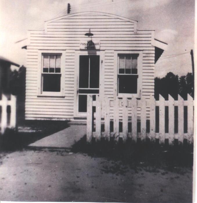
3 First Post Office


4

5 First Cabin on Lake Washburn 1918 Additional Information Tromeli was the name of a house in Old Outing, overlooking the lake. Mr. Mebis owned it and named it after a street in Kansas City where he was an insurance man. President Truman came up to visit him. President Truman was then a county commissioner. When the lumbering industry first started in this part of the country, the forests, at that time, consisted mostly of mature trees. The two major species were Norway and White pines. During this time there was no undergrowth due to the vast shading on the forest floor which was covered with the needles of these conifers. Because of this, there was no deer habitation of any consequences because of the poor food supply. Cuyuna is one of many names with an interesting history. It was named for, and by, Cuyler Adams, a prospector and discoverer and his dog, Una, who accompanied him on his prospecting trips. A Mr. Thompson was an old settler and built the big barn at the Woods mansion. The house on the canal on Lawrence Lake where Daily's used to live was built in In 1914, the road was built on up to Remer. It used to take two days to go from the Narrows to Remer and back by way of the old Wagon trail. C. B. Meachum had the first store, about 1926, just a tar paper shack type, at the site where Just Up North, owned by Bonnie & Steve Just, now stands. (The old Lakeview Grocery.) Lakeview Grocery was owned and operated by Paul and Billie Erickson. Strangely enough, Bonnie and Steve Just own and reside in the home on Roosevelt Lake where Paul and Billie previously resided. Then Henry J. Luescher's built the store on the other side of the street, known as the Narrows Trading Post in 1926, ran it and lived in back of the store. They moved up on top of the hill by where the post office used to be, with the steep cement steps in Andy Andolshek bought the store in 1948 and later sold it to Kurt Hoffman and his brother. It burned down in the middle 1960's, along with the Dairy Queen that Kurt had added. The grocery store was rebuilt by the Hoffmans and is now Lake Country Grocery owned by Chris and Sara Smith. The Sussex Company logged the lakes around here. The Weyerhauser Lumber Company owned a lot of land around here but leased it out to other companies. They cut no lumber around here but cut north and east of Thunder Lake. Further north it was called Cork Pine and it was used for patterns and molding. The Bungalow at Emily was built by a Dr. Emny from Aldora, Iowa. At the time of the logging, there were two loggers by the names of Clarkie and
6 Adney (there is a lake named after him) who were sworn enemies and they shot each other in the Foley Motel in Aitkin. Emily started about 1894; Old Outing 1900; bridge built at the Narrows about Cass County History Summary When Cass County was created by legislative act on May 1, 1851, it became one of ten counties that existed in the Minnesota Territory. It remained as a created county and had no county officers until March 4, 1872 when it was first organized as a county, with its boundaries reduced as slices had been cut off when the following counties were established: Wright, Steams, Meeker, Todd, Morrison, Pope, Douglas, Ottertail, Wadena, Aitkin, Crow Wing, and Becker. Our county seat was located in West Brainerd, complete with a building that was used as a courthouse. Cass County remained a part of Crow Wing County until the re-organization in Cass County was fully organized on May 6, 1897 and Governor Clough had appointed P.H. McGarry of Walker, G.H. French of Cohasset, O.T. Wilson of Ellis, James F. Middleton of Backus, and T.J. Nary of Walker as the county's first commissioners. These commissioners then met that same day and also on the 7th to appoint the officers of the county. The county board established the county seat at Walker on May 7th, and purchased a new brick building in Block 14, original plat of Walker. That building presently houses Reed's Gifts. On May 8th, the chairman of the commissioners appointed a committee to proceed to Brainerd and secure all books pertinent to our county. Construction on our present courthouse began in and the building was dedicated on April 5, Cass County has 51 organized townships today, the first of which was Byron Township in 1898 and the last was Ottertail Peninsula in 1987.
The Early Settlers Revised: September 7, 2013
 The Early Settlers Revised: September 7, 2013 The earliest settlers were farmers. Among the largest farmers in 1860 were: Adams, of which there were several, Phillips, Lynch, Avery, Gere, Garrett and Malloy.
A Historical Timeline of Cedar Falls
 A Historical Timeline of Cedar Falls 1700-1750 The Meskwaki (Fox), after having been forced out of their former homes further east, move into the area by 1750. They are allied with the Sauk through language
THE SETTING REGION COMMUNITY ANALYSIS
 THE SETTING REGION COMMUNITY ANALYSIS REGION Historical Setting The Crane Lake waterway pre-dates the American Indians who traveled its waters for generations before it became a fur-trading route for the
Future Projects. District 3 Central Minnesota. mndot.gov/d3
 Future Projects District 3 Central Minnesota 20 2021 mndot.gov/d3 Cass 20-2021 Construction Central Minnesota MnDOT District 3 Walker 34 Hackensack CASS 84 Remer 200 Longville Hill City Wadena 29 Osakis
Minnesota. Sample file. Content Adviser: Douglass R. Anderson, Minnesota Department of Natural Resources
 t h i s l a n d i s y o u r l a n d Minnesota b y a n n h e i n r i c h s Content Adviser: Douglass R. Anderson, Minnesota Department of Natural Resources Reading Adviser: Dr. Linda D. Labbo, Department
MP : The Empire Toll Gate and Glen Arbor
 MP 255 256: The Empire Toll Gate and Glen Arbor This section includes the location of the Empire Toll Gate, Glen Arbor and a reservoir. Route Mile Marker X Y Longitude Latitude 1 U. S. Highway 40 255 439593.25
Narragansett School The History of the Murals at Narragansett School
 Narragansett School The History of the Murals at Narragansett School These murals, running east to west, are intended to present brief pictorial history of selected places and events from Gorham's past.
The Original Farm, Dairy & Sausage plant buildings
 The Original Farm, Dairy & Sausage plant buildings Featured below are images of the original Deerfoot farm buildings along Stony Brook. Beginning in 1894, the original farm buildings along with 20 acres
New Jersey State Parks
 New Jersey State Parks History and Facts Kevin Woyce Photographs by the author Kevin Woyce NEW JERSEY STATE PARKS: HISTORY AND FACTS Copyright 2011 Kevin Woyce All Rights Reserved. No part of this book
GROWTH IN THE TOURISM INDUSTRY
 TOURISM & THE MINNESOTA ECONOMY ANNUAL ECONOMIC IMPACT Travel/tourism in Minnesota generates: $10.5 billion in gross sales $650 million in state sales tax CONTRIBUTING TO THE ECONOMY Travelers in Minnesota
The Tanska Resort and Family Tanska Auto Camp
 The Tanska Resort and Family Tanska Auto Camp The Tanska Auto Camp was an early twentieth-century retreat located on the northwestern shore of Pine Lake on the Sammamish Plateau (King County), operating
Historic Overview of Queen Street East, North Side (between the Don River and Broadview Avenue)
") Historic Overview of Queen Street East, North Side (between the Don River and Broadview Avenue) ATTACHMENT NO. 4 The following provides an overview of the three periods of the historic development of the
Historic Overview of Queen Street East, North Side (between the Don River and Broadview Avenue) ATTACHMENT NO. 4 The following provides an overview of the three periods of the historic development of the
Listing of Campsites on the Manigotagan River
 Listing of Campsites on the Manigotagan River This document lists and describes the campsites along the Manigotagan River between Highway #314 and the government dock in the community of Manigotagan. The
2019 Minnesota United Snowmobilers Association Winter Rendezvous February 7th to 10th Cragun s Resort East Gull Lake, Minnesota
 2019 Minnesota United Snowmobilers Association Winter Rendezvous February 7th to 10th Cragun s Resort East Gull Lake, Minnesota Brainerd Lakes Area Snowmobile Trails Covering a land area of 1,670 square
September 24, :43 PM THEMED SCHOOL FIELD TRIPS PIONEER INDIANA
 September 24, 2015 2:43 PM THEMED SCHOOL FIELD TRIPS PIONEER INDIANA Gallery PIONEER INDIANA Using the galleries and public spaces of the Indiana State Museum, answer the following questions. Q: If pioneer
FOR SALE : Land. XXXX St. Croix Trail S, Denmark Township, MN ACRES/4 PARCELS - RESIDENTIAL DEVELOPMENT FACTS & FEATURES
 FACTS & FEATURES List Price: $560,000 Property Type: Residential Land for Development Total Site - 10 Acres Currently Could Build 2 Homes on 5 Acres each Being Re-Platted for 4 lots ~2.5 Acres each Zoning:
Bemidji: A Pioneer Community of the 1890's'
 Bemidji: A Pioneer Community of the 1890's' Harold T. Hagg MORE THAN a century before the beginnings of permanent setdement at Lake Bemidji a fur-trading post was built on its shores. About 1785 it seems
Glasco, Kansas Birthplace of Paul H. Lahr
 Glasco, Kansas Birthplace of Paul H. Lahr Paul and John Lahr in the back yard of Paul s old house. View looking north with the ditch that Paul remembers along the north edge of the property. Glasco, Kansas
Hickman s (Diamond) Mills
 Mills") Hickman s (Diamond) Mills On the east branch of Naaman's Creek, near the northwest boundary of Lower (and Upper) Chichester townships, was the saw- and grist-mill of Samuel Hickman, which was one of the
Hickman s (Diamond) Mills On the east branch of Naaman's Creek, near the northwest boundary of Lower (and Upper) Chichester townships, was the saw- and grist-mill of Samuel Hickman, which was one of the
LOG CABIN (Now at Fiddler s Grove, Lebanon, Tenn.)
") LOG CABIN (Now at Fiddler s Grove, Lebanon, Tenn.) Property and Cabin first owned by Gleaves Family and probably constructed by them John Donelson of the County of Tennessee 640 acres - $600 written 1/11/1796
LOG CABIN (Now at Fiddler s Grove, Lebanon, Tenn.) Property and Cabin first owned by Gleaves Family and probably constructed by them John Donelson of the County of Tennessee 640 acres - $600 written 1/11/1796
History/Descriptive Notes: 3.5 acres with orchard that was actively used until current owner purchased in 1982.
 Address: 4395 McCandlish Road Tax Parcel Number: 12-22-200-031 Year Built: 1926 (per owner) Architectural Style: Craftsman Other Buildings/Features: garage (date unknown) 61 History/Descriptive Notes:
The History of the Thunder Basin
 The History the Thunder Basin 21 Written as script by Betty Pellatz, Earl Reed and Jewell Reed REPORTER: Goes out in the audience and gets Earl, Jewell, and Betty REPORTER: I m Nancy Geehan from the Bill
Weber Point The First Sammamish Lumber and Shingles
 Weber Point The bunkhouse picture is "Courtesy Issaquah History Museums, Neg. 2005.1.18" Weber Point, located on the eastern shores of Lake Sammamish in the northern part of the city of Sammamish, is today
Big Sable Point Lighthouse Les & Arlene Meverden Ludington, MI 49431
 Les & Arlene Meverden Ludington, MI 49431 My Interview with Les and Arlene Meverden and their daughter Janet was held on June 5, 2004. I first learned about the Meverden family through an article published
Feature Article. Fall City: The Hotel Corner since (southeast corner of 337th SE and Redmond-Fall City Rd)
") Feature Article Fall City: The Hotel Corner since 1886 (southeast corner of 337th SE and Redmond-Fall City Rd) Fall City ca.1887 In this very early photo, the river-powered ferry run by the Rutherford
Feature Article Fall City: The Hotel Corner since 1886 (southeast corner of 337th SE and Redmond-Fall City Rd) Fall City ca.1887 In this very early photo, the river-powered ferry run by the Rutherford
Compiled by John Tamagni THE THOMPSON FAMILY
 Compiled by John Tamagni THE THOMPSON FAMILY William Burdette Thompson 1809-1853 Mary Ann Russell Thompson Cole 1818-1900 Fannie Thompson 1850-1856 1. William B. Thompson arrives at Bridgeport in 1849
MINNEAPOLIS MEETING SEPTEMBER 7-13, 1951
 and shrubs. In the Alpine Garden, just above the snows of the large ravines, a large proportion of the alpine herbs and low shrubs will be in full bloom. Other representatives of the subarctic flora will
Address: Fenton Road Tax Parcel Number: Year Built: 1929
 Site Name: Camp Copneconic 39 Address: 10407 Fenton Road Tax Parcel Number: 12-31-300-001 Year Built: 1929 (date source: Tax records) Architectural Style: American Lodge/Timber Framed Other Buildings/Features:
Jackson County Historical Society News
 Jackson County Historical Society News volume twenty, number four September 2013 The Jackson County Historical Society will meet for a Hot Dog Picnic on September 12, 2013, at 6:30 p. m., at the Pat Bell
After the war ended the returning soldiers and the growing population needed jobs
 After the war ended the returning soldiers and the growing population needed jobs Many who could not find jobs moved away to Canada or the United States The fishery was still the main employer but after
Maggie s Weekly Activity Pack!
 Maggie s Weekly Activity Pack! Name Date Remembering A Great Adventure The Journey of Lewis and Clark It has been two hundred years since Lewis and Clark started their journey across America. In February
The 2 Man Trail Crew
 The 2 Man Trail Crew The year was 1972. We had just returned to the mountain town of Field from my work with the Avalanche Research team in Rodgers Pass. Grace and I moved into our small house along side
A CONCEPT FOR F.H. BARBER PROVINCIAL PARK.
 A CONCEPT FOR F.H. BARBER PROVINCIAL PARK. 2-7-4-101-27 APPROVAL This Concept for F.H. Barber Provincial Park has been reviewed and is approved. Lower Mainland Region Parks and Outdoor Recreation Division
MP : The Big Chief Overlook and the Glen
 MP 253 254: The Big Chief Overlook and the Glen The mile between MP 253 and 254 has lots of history in it. It includes the only recorded remains of the Victory Highway on the Clear Creek County side of
The Brick Yards of Steamboat Springs
 The Brick Yards of Steamboat Springs The Maxwell Building, built from local bricks in 2008 By James Logan Crawford Copyright 2017 www.crawfordpioneersofsteamboatsprings.com The Brick Yards of Steamboat
Of* HABTZSLL, JAMES LANS. INTJRVI W 7854 * ^
 Of* HABTZSLL, JAMES LANS. INTJRVI W 7854 * ^ HABTZSLL, JUOBS LlHB. IOTER7IEW. #7854 94 An Interview with Mr. James Lane Hartzell, Tulsa, Oklahoma. By - W, T. Holland - Interviewer. October 18, 1937. My
Town. Place (neighborhood or village) Address. Source. Style/Form. Foundation. Wall/Trim. Roof. Condition. Acreage. Setting
 Address. Source. Style/Form. Foundation. Wall/Trim. Roof. Condition. Acreage. Setting") FORM B BUILDING MASSACHUSETTS HISTORICAL COMMISSION Photograph Assessor s Number USGS Quad Area(s) Form Number 077005 Cotuit E 22 Town Barnstable Place (neighborhood or village) Address 3600 Falmouth Road/Route
FORM B BUILDING MASSACHUSETTS HISTORICAL COMMISSION Photograph Assessor s Number USGS Quad Area(s) Form Number 077005 Cotuit E 22 Town Barnstable Place (neighborhood or village) Address 3600 Falmouth Road/Route
THE BARNACLE 3485 MAIN HIGHWAY
 THE BARNACLE 3485 MAIN HIGHWAY Designation Report City of Miami REPORT OF THE CITY OF MIAMI PLANNING AND ZONING DEPARTMENT TO THE HISTORIC AND ENVIRONMENTAL PRESERVATION BOARD ON THE POTENTIAL DESIGNATION
A Brief History of Williams. by Marlys Hirst
 A Brief History of Williams by Marlys Hirst Williams, Minnesota got its start when the Canadian railway line from Winnipeg to Thunder Bay was built through the area between 1899 and 1900. Two men who worked
March (Information collected from ltihistoricalsociety.org. Image courtesy of the Leeds and Thousand Islands Archives)
") March 2017 DATE POST IMAGE 1 Pictured below is the Brady Barn. This timber frame barn was built on Berryton Road in the 1920's. The timbers were sawn rather than hewn, but the finishing and assembly of
March 2017 DATE POST IMAGE 1 Pictured below is the Brady Barn. This timber frame barn was built on Berryton Road in the 1920's. The timbers were sawn rather than hewn, but the finishing and assembly of
Minnesota Great River Road Transportation Alternatives Local Project Summaries December 19, 2016
 Minnesota Great River Road Transportation Alternatives Local Project Summaries December 19, 2016 For MN-MRPC Consideration on January 5, 2017 and Potential Letters of Support Aitkin pg. 2 Brainerd pg.
Hunter Water S170 Register
 SHI No.: 3630112 Location Name: 800 Salisbury Rd, Munni NSW 2420 Other ID nos HW ID: 130. Description: The house is set on a buff over looking the creek The house is built in the colonial style, single
next purchase at Antelope Springs Ranch. These centrally located parcels are strategically positioned between Roswell and Artesia, New Mexico.
 Wide open spaces and beautiful sunsets! That s what you get when you make your next purchase at Antelope Springs Ranch. These centrally located parcels are strategically positioned between Roswell and
Tape Log. 004 Born 1905 in Riverdale. Talks about grandmother taking him to a farm in Riverdale after his mother died.
 b-% Tape Log Interviewer: Will Jones Tape#: 5.20.95-S.R.l Interviewee: Shaird Robinson Mono: Stereo: X No. of Sides: 2 No. of Tapes: 1 Interview Date: May 20, 1995 Location: New Bern, NC. 000 Introduction
Wallace Lake Provincial Park. Management Plan
 Wallace Lake Provincial Park Management Plan 2 Wallace Lake Provincial Park Table of Contents 1. Introduction... 3 2. Park History... 3 3. Park Attributes... 4 3.1 Natural... 4 3.2 Recreational... 4 4.
HISTORICAL MARKERS issued by
 HISTORICAL MARKERS issued by INDIANA HISTORICAL BUREAU in MONTGOMERY COUNTY, INDIANA 2016 Compiled by Dian Moore, Montgomery County historian NUMBER NAME 54.1962.1 Lane Place 54.1963.1 Major General Lew
illing Era power for our society, in this age of alternate forms of energy, falling water may seem like a quaint old-fashioned way to power a mill.
 Saint Anthony Falls Historic Walking Tour The tour starts at the Father Hennepin Park sign shown below, a half block south of the intersection of SE Main Street and SE 3 rd Avenue on the east side of the
60 years on, Emmett Till's family visits the site of his "crime" and death
 60 years on, Emmett Till's family visits the site of his "crime" and death By Washington Post, adapted by Newsela staff on 09.13.15 Word Count 941 Spectators observe as members of Provine High School's
Yankee Hill Dispatch
 Yankee Hill Dispatch Vol 2 No 3 Dec 2008 Published by the Yankee Hill Historical Society www.yankeehillhistory.com P.O.Box 4031, Yankee Hill, Ca 95965 Wishing You Happy Holidays And A Prosperous 2009 Our
This now empty lot on the west side of Elm Street was the home of Dr. Johnson. This house was the first hospital in Carlisle, Kentucky.
 This now empty lot on the west side of Elm Street was the home of Dr. Johnson. This house was the first hospital in Carlisle, Kentucky. It was torn down to make a parking lot. The 55 th building In the
Plantation House Hotel
 Preservation South Carolina Request for REDEVELOPMENT PROPOSALS for the Plantation House Hotel Edgefield, South Carolina The History of the Dixie Highway / Plantation House Hotel The early 1890s found
The Holzworth Family. Papa, Marie, Julia, John, Sophie and Mama. Johnnie Holzwarth and Caroline (Pratt) Virginia, Mary Francis and John III
 Virginia, Mary Francis and John III") The Holzworth Family John Gotlieb Holzworth Sophie Lefromm Holzworth Papa, Marie, Julia, John, Sophie and Mama Johnnie Holzwarth and Caroline (Pratt) Virginia, Mary Francis and John III HOLZWORTH TROUT
The Holzworth Family John Gotlieb Holzworth Sophie Lefromm Holzworth Papa, Marie, Julia, John, Sophie and Mama Johnnie Holzwarth and Caroline (Pratt) Virginia, Mary Francis and John III HOLZWORTH TROUT
A Visit to Cloud Cap Inn
 October 2018 A Visit to Cloud Cap Inn Webfooters Post Card Club PO Box 17240 Portland OR 97217-0240 www.thewebfooters.com A Visit to Cloud Cap Inn Above the Clouds Mountain climbers visit Cloud Cap Inn,
COPPERFIELD HOMESTEAD 240 Acres Fremont County, CO $820,000
 F a r m, Ranch & Recreation a l Real Esta t e COPPERFIELD HOMESTEAD 240 Acres Fremont County, CO $820,000 http://www.haydenoutdoors.com/land-for-sale/copperfield-homestead PROPERTY SUMMARY $820,000 Total
Uncle James Howver The Gold Rush and a Lost Claim
 Uncle James Howver The Gold Rush and a Lost Claim There s Gold in Them Thar Hills! Susan McNelley Some men seek riches. Some men seek adventure. Some men yearn for both. Their stories often stir the imagination.
1MMILLIAM, SAI.TUKL L. INTiBVliiW,f9S00
 1MMILLIAM, SAI.TUKL L. INTiBVliiW,f9S00 - 8 - Form A-(S-149) BIOGRAPHY" FORM WORKS PROGRESS ADMINISTRATION 227 Indian-Pioneer History. Project for Oklahoma McMILLIAM, SAMUEL L, IHTEEVIEW. #9300 Field WorkerV-
SSTS Professionals. Please visit the MPCA website for license verification and additional information:
 SSTS Professionals Please visit the MPCA website for license verification and additional information: www.pca.state.mn.us City Business Name Certified Individual Phone Installer Aitkin A & J Inspecting
Yankee Hill Dispatch
 Yankee Hill Dispatch Vol 2 No 1 Feb 2008 Published by the Yankee Hill Historical Society www.yankeehillhistory.com P.O.Box 4031, Yankee Hill, Ca 95965 The Yankee Hill Dispatch is published three times
Archaeology Internship in the Great Smoky Mountains National Park Summer 2010, Leila Donn
 Archaeology Internship in the Great Smoky Mountains National Park Summer 2010, Leila Donn This past summer I spent three months working as an archaeology intern in the Great Smoky Mountains National Park
The Wieden Place. Portion of Plat Map Drawn After 1889 and Before Wiedens and Wiedens Roses
 The Wieden Place Anyone sitting on Bench Six today who is looking north to Allman Avenue would see heavy traffic and modern buildings. Students on fifteen or more school busses travel that route on their
Wallace Lake Provincial Park. Draft Management Plan
 Wallace Lake Provincial Park Draft Management Plan Wallace Lake Provincial Park Draft Management Plan Table of Contents 1. Introduction... 3 2. Park History... 3 3. Park Attributes... 4 3.1 Natural...
DRIVING TOUR OF PICKETT COUNTY TN THROUGH PHOTOS Traveling east on Hwy 111 starting at the Overton/Pickett County Line
 DRIVING TOUR OF PICKETT COUNTY TN THROUGH PHOTOS Traveling east on Hwy 111 starting at the Overton/Pickett County Line Welcome Sign as one enters County County Line Flea Market and Auction Historic Church
243 West Main Researched and written by Ruth Ann Montgomery
 243 West Main Researched and written by Ruth Ann Montgomery Steve and Carol Culbertson s home at 243 West Main was built in 1881. The architectural style of the house is Victorian Vernacular. The name
BROCHURE. APPLE HILL WOODS 118 +/- Acres Camino, California. Presented by Jim Copeland
 BROCHURE APPLE HILL WOODS 118 +/- Acres Camino, California Presented by Jim Copeland 1 The Property This 118 acre is a rare gem in the Sierra Nevada foothills. Covered with lush forestland and scattered
Maggie s Activity Pack!
 Maggie s Activity Pack! Name Date Remembering A Great Adventure The Journey of Lewis and Clark Two hundred years ago, in February 1803, President Thomas Jefferson got approval from the United States Congress
NNHS NEWS LETTER MEMORIES OF HIGH ROCK LODGE. Issue 35 August 2013 Editor Gail M Cramer. Northville Northampton Historical Society
 NNHS NEWS LETTER Northville Northampton Historical Society MEMORIES OF HIGH ROCK LODGE I know most all of you know about HIGH ROCK LODGE, but maybe there s some things about it you don t know or have forgotten.
Letter Assessment. (date) Dear, In 1864, Then in 1866, In 1867, As it happened in 1868, Then in 1877, The bust came in.
 Dear, In 1864, Then in 1866, In 1867, As it happened in 1868, Then in 1877, The bust came in.") Letter Assessment (date) Dear, In 1864, Then in 1866, In 1867, As it happened in 1868, Then in 1877, The bust came in. Your friend, The Birth of a City and Railroad in the Rocky Mountains Modified for
Letter Assessment (date) Dear, In 1864, Then in 1866, In 1867, As it happened in 1868, Then in 1877, The bust came in. Your friend, The Birth of a City and Railroad in the Rocky Mountains Modified for
Would You Like Your Salad With Worms, or Without? There s a worm on my salad, Olympia said. Mike peered at the wriggling,
 Name Sailing Home Read the selection. Then answer the questions that follow. Would You Like Your Salad With Worms, or Without? There s a worm on my salad, Olympia said. Mike peered at the wriggling, green
2018 The Friends of Two Rivers Mansion, a 501(c)(3) organization McGavock Pike,
(3) organization McGavock Pike,") NEWSLETTER Number 42 May - June 2018 The Friends of Two Rivers Mansion, a 501(c)(3) organization 3130 - McGavock Pike, President Larry Weber's Remarks - With summer around the corner, let s get ready to
NEWSLETTER Number 42 May - June 2018 The Friends of Two Rivers Mansion, a 501(c)(3) organization 3130 - McGavock Pike, President Larry Weber's Remarks - With summer around the corner, let s get ready to
Finally it was unloaded from the power carrier and moved into place using rock bars and brute strength.
 The Longest Mile It has been many years since work first began on this rugged and remote one-mile segment of the MCCT between Patti s Point and the Lower Log Boom on Pardee Watershed. EBMUD mounted patrolmen
Section 1: Vocabulary. Be able to determine if the word in bold is used correctly in a sentence.
 Section 1: Vocabulary. Be able to determine if the word in bold is used correctly in a sentence. Hardships: difficult conditions or situations that cause discomfort and/or suffering Pioneers: the people
The Kitigan Zibi Reserve is located 130 kilometres north the new amalgamated city of Gatineau.
 DESCRIPTION The Kitigan Zibi Indian Reserve consists of the township of Maniwaki, less the portion occupied by the city of Maniwaki, the Provincial Highway 105 crossing the reserve, and the land occupied
RETURN TO THE LOST ADAMS DIGGINGS
 RETURN TO THE LOST ADAMS DIGGINGS My name is Richard U. French, friends call me Dick. I want to tell you a story; it is a story about gold. In the closing months of the American Civil War, in 1864, an
Attached for your consideration and comment is the proposed 2017 Crow Wing County AIS Prevention Plan.
 MEMORANDUM Land Services Department Mark B. Liedl, Director TO: Crow Wing County Commissioners Crow Wing County Administrator Townships, Crow Wing County Municipalities, Crow Wing County Aitkin County
SNAPSHOT Investing in Roads and Bridges 2016 Budget for a Better Minnesota
 SNAPSHOT Investing in Roads and Bridges 2016 Budget for a Better Minnesota Modern roads, bridges, and transit are the foundation of an economy that works for all Minnesotans everywhere in Minnesota. Our
Subject(s): Innes, Walter/Innes Department Store
: Innes, Walter/Innes Department Store") Tihen Notes Subject Search, p. 1 Dr. Edward N. Tihen (1924-1991) was an avid reader and researcher of Wichita newspapers. His notes from Wichita newspapers -- the Tihen Notes, as we call them -- provide
Tihen Notes Subject Search, p. 1 Dr. Edward N. Tihen (1924-1991) was an avid reader and researcher of Wichita newspapers. His notes from Wichita newspapers -- the Tihen Notes, as we call them -- provide
TOWERBUTTE. Lewis and Clark s. >> By Jerry Penry, LS
 4.95 Lewis and Clark s TOWERBUTTE >> By Jerry Penry, LS Have you ever felt like you are standing on hallowed ground, knowing that some very important surveyors had previously occupied that same location?
The President James K. Polk State Historic Site Teacher s Packet
 The President James K. Polk State Historic Site Teacher s Packet 2008-2009 Mailing Address: PO Box 475 Pineville, NC 28134 Street Address: 12031 Lancaster Highway Pineville, NC 28134 (704) 889-7145 phone
Bear Butte State Park Trail System NORTH
 Trail System 4426 4250 4000 3750 3500 3250 NORTH SCALE IN FEET 0 1000 2000 Summit Trail Type of trail: Hiking Length of trail: 1.85 miles Trail surface: Dirt and rock Rated: Moderate, somewhat hilly, even
HISTORY OF BERKLEY Reference: BRIEFLY, BERKLEY by Shirley McLellan (called S.McLellan: B,B)
") HISTORY OF BERKLEY Reference: BRIEFLY, BERKLEY by Shirley McLellan (called S.McLellan: B,B) In the beginning, the land - - - was part of a vast forest and a swamp which rivaled none in the country. It
HISTORY OF BERKLEY Reference: BRIEFLY, BERKLEY by Shirley McLellan (called S.McLellan: B,B) In the beginning, the land - - - was part of a vast forest and a swamp which rivaled none in the country. It
Park-specific management and policies Wainuiomata Recreation Area
 Park-specific management and policies Wainuiomata Recreation Area 6.8 Wainuiomata Recreation Area 6.8.1 Legal status Title held: Legislative status: Wellington Regional Council Administered under Local
Daisy Dean Creek Ranch
 Daisy Dean Creek Ranch MARTINSDALE, MONTANA Hunting Ranching Fly Fishing Conservation Daisy Dean Creek Ranch MARTINSDALE, MONTANA Introduction: Daisy Dean Creek Ranch is comprised of 1,652 acres with a
B is for British Columbia. A is For Alberta
 C is for Canada A is For Alberta Alberta is one of the only provinces in Canada with 2 NHL teams. Edmonton, the capital of Alberta is the home of the West Edmonton Mall, which is the largest shopping mall
Mississippi River Parkway Commission of Minnesota
 Mississippi River Parkway Commission of Minnesota Metro Region (Elk River to Hastings) October 27, 2016 2:00 3:30 p.m. Historic Fort Snelling 200 Tower Avenue, St. Paul, MN Metro Region Agenda I. Welcome
Tour 12 - Historic Plumas County
 SPECIALTY tour 12 page 1 Tour 12 - Historic Plumas County This tour highlights many of Plumas County s historic attractions and small museums. Local experts may be available for tours or presentations
A.M. Irene, how long has your family been farming in this area?
 Irene Jorgensen (in her home) Interviewed by Ann Melhaus February 11, 2005 A.M. Irene, how long has your family been farming in this area? Since 1913. A.M. Okay. And who acquired the farm, originally?
21297 CR 59, RIVERTON, MN 56455
 INDUSTRIAL FACILITY, MN 56455 COMMERCIAL REAL ESTATE BUSINESS BROKERAGE LAND & BUILDING DEVELOPMENT INVESTMENT & INCOME PROPERTIES TAX DEFERRAL STRATEGIES { Table of Contents } Page 3-5 Features 6 Floor
Howard and Be y Barn Quilt Tour # 1 (the rest you ll have to do on your own. There are many more murals and barn quilts in Marque e County).
.") Howard and Be y Barn Quilt Tour # 1 (the rest you ll have to do on your own. There are many more murals and barn quilts in Marque e County). 3 2 This is a photo of the Germania Hotel from the 1890s. It
Howard and Be y Barn Quilt Tour # 1 (the rest you ll have to do on your own. There are many more murals and barn quilts in Marque e County). 3 2 This is a photo of the Germania Hotel from the 1890s. It
Possible Brother to David Chadwell
 Possible Brother to David Chadwell 2. John Chadwell Born: Resided 1770, Pittsylvania Co., Va./Rockingham Co., N.C. Died January 12, 1794, Rockingham Co., N.C. Married: Before 1783 Father: George Chadwell
2. Houses on the Marbury Hall Site
 2. Houses on the Marbury Hall Site During the 13 th Century, the Merburie family built a house, originally of timber and thatch, which was to remain the family home until the last male heir, Richard Marbury,
In 1850, Congress passed a law donating two and one half million acres to the State of Illinois for the use of the Illinois Central Rail Road.
 Merna The town of Merna was founded by primarily Irish and German farmers. Their faith and families were an integral part of who they were. There was and still is today a strong sense of community. Most
From Commemorative Biographical Record of the Counties of Rock, Green, Grant, Iowa and Lafayette Wisconsin, publ page
 From Commemorative Biographical Record of the Counties of Rock, Green, Grant, Iowa and Lafayette Wisconsin, publ. 1901 - page 423-424 ASAPH J. ALLEN, an energetic and enterprising gentleman, whose manly
LENNARD SHELL VALLEY, MANITOBA
 A BRIEF HISTORY OF LENNARD AND SHELL VALLEY, MANITOBA BY JOHN GOODES A BRIEF HISTORY OF LENNARD AND SHELL VALLEY 2 I. Lennard For the settlers from Bucovina who began to arrive in the Asessippi district
CHATHAM COUNTY HISTORIC PRESERVATION COMMISSION HISTORIC PROPERTY DESIGNATION STAFF RECOMMENDATION
 CHATHAM COUNTY HISTORIC PRESERVATION COMMISSION HISTORIC PROPERTY DESIGNATION STAFF RECOMMENDATION ISSUE: FILE NUMBER: Designation of Pennyworth Island as a Local Historic Property DP20110328-12-1 DATE:
First Floor Plan. Second Floor Plan
 The Flint Homestead was built by 1709 for Ephraim Flint (1641 1723) and his wife Jane Bulkeley. They did not have any children. In 1723 he willed his mansion house to his nephew, John Flint, and to John
Brown County Cabins Varies Brown County Getaways Varies Brown County Inn Near the Village B'twixt the Ridges Lo
 1078 Hideaway 812.345.9726 Northeast 1875 Homestead B&B 812.988.0853 Southeast Abbey Inn 812.988.2397 Southwest Abe Martin Lodge 812.988.4418 Southeast Adventurewood Log Cabin 812.438.2992 Southwest All
A History of West Chicago
 A History of West Chicago The Prairie Prairie Inhabitants Winfield Mounds Dickson Mounds, near Lewistown, in southern Illinois. An example of what Native burial mounds look like. First Permanent Settlers
Francis Family Bus Tour July 16, 1999
 Francis Family Bus Tour July 16, 1999 Thank you for joining us. We have prepared a brief synopsis of the points of interest that we will see today. We are pleased to have Earl and Marjorie Lindsay along
Pioneer Fashioned Home from Glade Park Cave
 Pioneer Fashioned Home from Glade Park Cave Laura Hazel Miller, standing between gate posts, in her cave on Glade Park. The one room house was entirely within the cave, and smaller storehouses extended
The Changing Face of Bonnersfield and Sheepfolds Area of Monkwearmouth
 The Changing Face of Bonnersfield and Sheepfolds Area of Monkwearmouth What was the origin of these names? They were obviously rural and farming related but by the 18 th century the land was becoming industrialised.