Metro EXTRA Service Plan. District of Columbia Rapid Bus Study. Georgia Avenue 7 th Street Corridor. November 2006
|
|
|
- Phoebe Leonard
- 5 years ago
- Views:
Transcription


1 Metro EXTRA Service Plan Georgia Avenue 7 th Street Corridor District of Columbia Rapid Bus Study November 2006
2 LIST OF EXHIBITS TABLE OF CONTENTS Section 1: Existing Conditions....1 Exhibit 1: Georgia Avenue 7 th Street Corridor....1 Exhibit 2: Roadway Width and Lane Configuration, Georgia Avenue 7 th Street Corridor....2 Exhibit 3: Weekday Traffic Volumes Exhibit 4: Level of Service Exhibit 5: Bus Routes 70, Exhibit 6: Existing Boardings and Destinations Exhibit 7: Area Not Served by Existing Metro..5 Exhibit 8: Weekday Boardings by Stop, Route Exhibit 9: Boarding and Alighting Activity, Route (Northbound) 7 Exhibit 10: Boarding and Alighting Activity, Route (Southbound).. 8 Exhibit 11: Peak Hour, Peak Direction Bus Load Levels, Route Exhibit 12: Weekday Transit Travel Speed, Route Exhibit 13: Travel Time between Timepoints and Travel Speed by Time of Day (Northbound).. 11 Exhibit 14: Travel Time between Timepoints and Travel Speed by Time of Day (Southbound).. 11 Section 2: Metro EXTRA Service Plan..12 Exhibit 15: Georgia Avenue 7 th Street NW Corridor Metro EXTRA Service Plan Exhibit 16: Georgia Avenue 7 th Street Proposed Metro EXTRA Rapid Bus Service...13 Exhibit 17: Georgia Avenue 7 th Street NW Corridor Metro EXTRA Strip Map...14 Exhibit 18: Georgia Avenue 7 th Street Corridor, Proposed Rapid Bus Stops...15 Exhibit 19: Georgia Avenue 7th Street Proposed Metro EXTRA Stop Requirements for Short Term..19 Exhibit 20: Estimated Rapid Bus Speed and Travel Time Exhibit 21: Operating Statistics for Georgia Avenue 7 th Street Metro EXTRA Service Exhibit 22: Georgia Avenue 7 th Street Capital Costs...23 Section 1: Existing Conditions...1 Roadway Configuration... 1 Traffic Conditions... 1 Existing Transit Service... 4 Section 2: Metro EXTRA Service Plan for Georgia Avenue 7 th Street NW Corridor...12 Service Concept Vehicles Stop Locations Running Way Improvements Travel Speed and Travel Time Ridership Operating Costs Capitol Costs Appendix A: Georgia Avenue 7 th Street Corridor Proposed Rapid Bus Service Appendix B: Georgia Avenue 7 th Street Corridor Pictures of Existing Conditions at Stop Locations Appendix C: Georgia Avenue 7 th Street Corridor Requested Stop Improvements i

3 Section 1: Existing Conditions The Georgia Avenue 7 th Street Corridor is defined as the following streets: 7 th Street NW between Pennsylvania Avenue NW and Florida Avenue NW 9 th Street NW between M Street NW and Pennsylvania Avenue NW Georgia Avenue NW between Florida Avenue NW and Eastern Avenue NW A possible extension via Georgia Avenue and Wayne Avenue to Silver Spring Metro Roadway Configuration Roadways in the study corridor are primarily 2 way, although 9 th Street is a one way (southbound) street between Mount Vernon Place NW and Pennsylvania Avenue NW. Land uses along 7 th Street and Georgia Avenue are primarily commercial, and vary from high density in the downtown area (roughly south of Mount Vernon Place) to small scale, neighborhood commercial in the northern sections of the alignment. Major trip attractors along the corridor include: Downtown Washington o Chinatown o The Verizon Center The Washington Convention Center Howard University The Howard University Medical Center Walter Reed Medical Center Downtown Silver Spring Traffic Conditions Exhibit 2 shows the roadway configuration in terms of the number of lanes, right of way widths, and parking regulations along the corridor. Exhibit 3 shows the average daily traffic volumes in the corridor. The exhibit shows that the highest volumes are in the northernmost part of the corridor, where it crosses into the District from Montgomery County. South of Piney Branch Road, the traffic volume begins to drop as traffic diverts onto other major north south roadways, including Piney Branch Road, 13 th Street, and New Hampshire / Sherman Avenue. By the time 7 th Street reaches downtown Washington, traffic volumes are relatively light, as the roadway operates in a grid street network with numerous parallel alternative routes; and as the level of service on Metrobus and Metrorail modes increase. This traffic pattern is reflected in the roadway Level of Service (LOS), shown in Exhibit 4. The northernmost segment of Georgia Avenue north of Piney Branch Road has a LOS F, as this segment carries the heaviest traffic on the roadway. Traveling south, the roadway functions at LOS D or better on all segments north of the downtown area. In downtown Washington, even thought the traffic counts are relatively low, the LOS returns to F, reflecting the relatively narrow roadway and the impacts of signalized intersections at every block. Exhibit 1: Georgia Avenue 7 th Street Corridor The alignment crosses six Metrorail stations: Archives Navy Memorial Penn Quarter (Green & Yellow Line) Gallery Place Chinatown (Green, Yellow & Red Line) Mount Vernon Square Convention Center (Green & Yellow Line) Shaw Howard U (Green Line) Georgia Avenue Petworth (Green Line) Silver Spring (Red Line) The alignment is shown in Exhibit 1. Exhibit 2 shows that there is curbside parking in at least some time periods for most of the corridor. This curbside parking is primarily utilized by the small scale businesses that line Georgia Avenue and 7 th Street for most of their lengths. Larger businesses like supermarkets tend to have their own parking lots located off street. There is limited residential development, which mostly has access to rear alleys for parking. Much of the on street parking is metered, with two hour time limits. 1
4 Exhibit 2: Roadway Width and Lane Configuration, Georgia Avenue 7 th Street Corridor Street Begin Segment ROW Curb to One Way? Travel Lanes Parking Lanes Parking Restrictions End Width (Ft) Curb (Ft) (Y/N) NB SB NB SB NB SB Georgia Ave. NW Eastern Avenue Shepherd Road N 3 3 No Parking No Parking 30,900 1,724 F Georgia Ave. NW Shepherd Road Piney Branch Road N Metered Metered 30,900 1,724 F Georgia Ave. NW Piney Branch Road Missouri Avenue N Metered Metered 24,100 1,345 D Georgia Ave. NW Missouri Avenue Buchanan Street N Metered Metered 22,700 1,267 D Georgia Ave. NW Buchanan Street Quincy Street N Metered Metered 22,500 1,256 D Georgia Ave. NW Quincy Street Irving Street N Metered Metered 23,000 1,283 D Georgia Ave. NW Irving Street Harvard Street N Metered Metered 21,600 1,205 D Georgia Ave. NW Harvard Street Bryant Street N Metered Metered 15, D Georgia Ave. NW Bryant Street Florida Avenue N AM/PM AM/PM 18,200 1,016 F Seventh St. NW Florida Avenue Rhode Island Avenue N AM/PM AM/PM 15, F Seventh St. NW Rhode Island Avenue Q Street N Metered AM/PM 15, F Seventh St. NW Q Street N Street N Metered Metered 15, F Seventh St. NW N Street Mt Vernon Place N Metered Metered 22,700 1,267 F Seventh St. NW Mt. Vernon Place Mass Avenue N 4 1 No Parking No Parking 17, D Seventh St. NW Mass. Avenue D Street N 1+1 transit Metered AM/PM 14, F Seventh St. NW D Street Penn Avenue N 1+1 transit Metered AM/PM 14, F Seventh St. NW Penn Avenue Constitution Avenue N AM/PM AM/PM 13, D Seventh St. SW Constitution Avenue Independence Avenue N AM/PM AM/PM 21,400 1,194 D Seventh St. SW Independence Avenue 1998 AWDT Peak Hour Volume C Street N Metered Metered 13, D Ninth St. NW N Street Mt. Vernon Place No Data No Data Y Metered Metered No Data No Data No Data Ninth St. NW Mt. Vernon Place New York Avenue No Data No Data Y Ninth St. NW New York Avenue Pennsylvania Avenue No Data No Data Y 2+1 transit 2+1 transit 4+1 transit 2+1 transit Peak Hr LOS Metered Metered No Data No Data No Data Metered Metered No Data No Data No Data 2

5 Exhibit 3: Weekday Traffic Volumes Exhibit 4: Level of Service Source: 1998 Traffic Counts cited in the DC Transit Development Study Source: 1998 Traffic Counts cited in the DC Transit Development Study; LOS Calculation: ITE traffic Manual 3

6 Existing Transit Service Exhibit 5: Bus Routes 70, 71 Transit in the Georgia Avenue 7 th Street Corridor is primarily provided by Metrobus Route Route is shown in Exhibit 5. Route operates between Silver Spring Metro in the north and four different southern terminals: L Enfant Plaza Maine Avenue / 9 th Street SW Pennsylvania Avenue / 9 th Street NW Half Street / O Street SW Service operates 7 days a week between 4:00 a.m. and 2:00 a.m. Trunk line headways are about 7 10 minutes in the peak (when both the 70 and the 71 routes operate) and about 10 minutes in the midday period (when just the 70 runs). Route is one of the busiest and most crowded Metrobus routes: There are about 17,000 daily boardings between Eastern Avenue and Archives There are about 22,000 daily boardings between Silver Spring and Buzzard s Point The highest load factor on the route is about 0.89, at Georgia Avenue / Irving Street Challenges: The purpose of the Rapid Bus Implementation Plan is to address several of the challenges faced by existing transit operations in the Georgia Avenue 7 th Street Corridor, including: Long travel times due to slow travel speeds and intersection signal delay o The roadway operates at level of service F south of Florida Avenue and north of Piney Branch Road o Between Petworth and Irving, transit speeds are below 8 mph all day o The total trip average speed is below 10mph for all southbound midday and PM peak trips, and all northbound AM peak, midday, PM peak and evening trips Poor schedule adherence (reliability) o 22% of southbound trips are more than 5 minutes late o 33% of northbound trips are more than 5 minutes late Insufficient capacity o Peak period, peak direction load factors exceed 0.8 in both directions o The most crowded point is Irving Street, with a load factor of 0.89 Imbalance of service between the northern and southern ends of the existing routes o There are too many trips to Buzzard s Point for the service demand in the area Limited passenger amenities at stops o Most stops lack shelters and benches; no stops have real time bus arrival information 4


7 Exhibit 6: Existing Boardings and Destinations Exhibit 7: Area Not Served by Existing Metro Existing origin and destination data for the Georgia Avenue 7 th Street Corridor are shown in Exhibit 6. The pattern suggests lots of short trips within the corridor, rather than the longer trips characteristic of Metrorail lines. Many of the trips may be between areas unserved by Metrorail and one of the stops along the route; much of the northern end of Georgia Avenue NW is unserved by Metrorail, as shown in Exhibit 7. The following exhibits show current conditions for transit service along Route 70 71: Exhibit 8 graphically shows the locations of the busiest boarding locations along the route Exhibit 9 and 10 lists all of the stops along the route and the total number of boardings and alightings at each location Exhibit 11 shows the bus load levels during the peak period Exhibit 12 shows the weekday transit travel speeds for Route Exhibits 13 and 14 show the travel time and speed between time points along the route 5

8 Exhibit 8: Weekday Boardings by Stop, Route Source: WMATA Ride check
9 Exhibit 9: Boarding and Alighting Activity, Route (Northbound) On Street Cross Street Total Weekday Boardings+ Rank Boardings+ Boardings Alightings Alightings Boardings Alightings Alightings SW BET 2 ND & 1 STS (TP 71 PM) WATER ST SW BET HALF & S (PM) WATER ST SW BET T & S STS (TP 71) FIRS SW FIRS SW HALF ST SW O ST (TP 70) SW FIRS SW CANA SW 3 RD ST SW 4 TH ST TH ST SW O ST (S) TH ST SW N ST TH ST SW M ST M ST SW 6 TH ST TH ST SW SW 7 TH ST MAINE AVE SW 9 TH ST (TP 70) SW 7 TH ST TH ST SW D ST SW 7 TH ST (TP 70) TH ST SW E ST (1 SOP) (TP) TH ST SW MARYLAND AVE TH ST SW INDEPENDENCE AVE TH ST NW CONSTITUTION AVE TH ST NW CONSTITUTION AVE (TP) TH ST NW PENNSYLVANIA AVE (TP) TH ST NW E ST TH ST NW TH ST NW H ST (TP) 1, , TH ST NW MASSACHUSETTS AVE TH ST NW TH ST NW M ST TH ST NW N ST TH ST NW O ST TH ST NW TH ST NW RHODE ISLAND AVE TH ST NW S ST TH ST NW (TP) , NW X NW NW BARRY PL X NW HOWARD PL NW EUCLID ST NW GRESHAM PL X NW IRVIN NW LAMON X NW NW X NW N. HAMPSHIRE AVE (N/N) (TP) NW N. HAMPSHIRE AVE (N/F) , NW RANDOLPH ST NW SHEPHERD ST NW UPSHUR ST NW WEBSTER ST NW BUCHANAN ST NW DECATUR ST NW EMERSON ST NW FARRAGU NW GALLATIN ST NW INGRAHAM ST NW KENNEDY ST (TP) NW MADISON ST NW MISSOURI AVE NW QUACKENBOS ST NW RITTENHOUSE ST NW NW NW VAN BUREN ST NW BUTTERNU X NW DAHLIA ST NW FERN ST (W) X NW GERANIUM ST X NW HEMLOC NW JUNIPER ST MC BLAIR RD (TP) MC BURLINGTON AVE MC SILVER SPRING AVE WAYNE AVE MC DIXON AVE SILVER SPRINA. MC BUS BAY A/B (TP) , TOTAL NORTHBOUND STOP ACTIVITY 11,185 11,185 22,369 TOTAL NORTHBOUND ACTIVITY, ARCHIVES TO BLAIR ROAD 9,620 8,483 18,102 Source: WMATA Ridecheck
10 Exhibit 10: Boarding and Alighting Activity, Route (Southbound) Total Weekday Boardings+ Rank Boardings+ On Street Cross Street Boardings Alightings Alightings Boardings Alightings Alightings SILVER SPRINA. MC BUS BAY J (TP) 1,953 1, MC BONIFAN MC SILVER SPRING AVE MC MC EASTERN AVE (TP) NW JUNIPER ST X NW HEMLOC X NW GERANIUM ST NW DAHLIA ST NW BUTTERNU NW VAN BUREN ST NW PINEY BRANCH RD NW RITTENHOUSE ST NW QUACKENBOS ST NW ROCK CREEK FORD RD NW MADISON ST NW KENNEDY ST (TP) NW INGRAHAM ST NW GALLATIN ST NW FARRAGU NW DECATUR ST NW BUCHANAN ST NW WEBSTER ST NW NW SHEPHERD ST NW RANDOLPH ST NW PETWORTH METRO , NW N. HAMPSHIRE AVE (TP) NW NEWTON PL NW NW LAMON NW IRVIN NW COLUMBIA RD NW GRESHAM PL NW EUCLID ST NW BANNEKER REC CTR NW BARRY PL NW X NW NW (TP) 195 1,045 1, NW NW S ST NW R ST NW NW NW N ST NW M ST NW NW MT VERNON PL NW NW H ST (TP) 296 1,164 1, NW NW E ST NW PENNSYLVANIA AVE (TP) NW CONSTITUTION AVE NW CONSTITUTION AVE(TP 70/) SW INDEPENDENCE AVE SW C ST D ST SW (TP 70) SW E ST X (TP) SW X SW X SW SW MAINE AVE MAINE AVE SW (TP) SW X SW ARENA STAGE M ST SW M ST SW BET 3RD & 4TH STS DELAWARE AVE SW M ST DELAWARE AVE SW # DELAWARE AVE SW CANA CANA SW (AM ONLY) O ST SW FIRS HALF ST SW O ST (TP) SW FIRS (PM ONLY) ND ST SW X ND ST SW S ST X ND ST SW X SW BET 2ND & 1SS(TP 71) WATER ST SW BET HALF & S (AM) WATER ST SW BET T & S STS (TP 71 AM) TOTAL SOUTHBOUND STOP ACTIVITY 10,153 10,153 20,305 TOTAL SOUTHBOUND ACTIVITY, EASTERN AVE TO ARCHIVES 7,274 8,440 15,713 Source: WMATA Ridecheck
11 Exhibit 11: Peak Hour, Peak Direction Bus Load Levels, Route Source: WMATA Ride check, Collected
12 Exhibit 12: Weekday Transit Travel Speed, Route Source: WMATA Passenger & Time Report,
13 Transit Travel Time and Speed between Time Points The WMATA Passenger and Time Report from was used to calculate transit travel time and speed between time points. The Passenger and Time Report lists the scheduled and actual time of arrival at time points along the route for every trip in the day in each direction. These were aggregated by time period to show the change in travel speed by direction by time of day; and to show where delays were resulting in very slow travel times between certain points. In addition, delay was also measured by comparing the scheduled and actual arrival times at each time point by direction and by time of day. Because there was significant variation in the amount of delay from early arrival to 20+ minutes of day the median delay at time points was measured. The results of this analysis are shown in Exhibit 13 (Northbound trips) and Exhibit 14 (Southbound). Exhibit 13: Travel Time between Timepoints and Travel Speed by Time of Day (Northbound) Travel Time (Min) Early AM AM Peak Midday PM Peak Evening After 12 Travel Speed (mph) Early AM AM Peak Midday PM Peak Evening After 12 Median Delay (Min) Early AM AM Peak Midday PM Peak Evening After 12 7 th /PA 7 th /H th /PA 7 th /H th /H GA/FL th /H GA/FL GA/FL GA/Irving GA/FL GA/Irving GA/Irving Petworth GA/Irving Petworth Petworth GA/Kennedy Petworth GA/Kennedy GA/Kennedy GA/Blair GA/Kennedy GA/Blair Total Trip Total Trip th /PA 7 th /H GA/FL GA/Irving Petworth GA/Kennedy GA/Blair Exhibit 14: Travel Time between Timepoints and Travel Speed by Time of Day (Southbound) Travel Time (Min) Early AM AM Peak Midday PM Peak Evening After 12 Travel Speed (mph) Early AM AM Peak Midday PM Peak Evening After 12 Median Delay (Min) Early AM AM Peak Midday PM Peak Evening After 12 GA/Eastern GA/Eastern GA/Kennedy GA/Eastern GA/Kennedy GA/Kennedy Petworth GA/Kennedy Petworth GA/ Kennedy Petworth GA/Irving Petworth GA/Irving GA/ Petworth GA/Irving GA/FL GA/Irving GA/FL GA/FL 7 th /H GA/FL 7 th /H th /H 7 th /PA th /H 7 th /PA Total Trip Total Trip GA/Irving GA/FL 7 th /H 7 th /PA Based on the results shown in Exhibits 13 and 14: Although there is consistent delay across all time points and time of day, the delay is on the whole fairly minor The slowest travel times are during the midday period in both directions, and travel speed does not appear to follow peak period travel patterns; this is representative of a roadway that carries lots of local trips and not a lot of commuting traffic The slowest travel is between the timepoints at Georgia and Irving and Petworth Metro, while the second slowest times were in the downtown area

14 Section 2: Metro EXTRA Service Plan for Georgia Ave 7 th Street NW Corridor The following section describes the Rapid Bus (Metro EXTRA) service concept for the Georgia Avenue 7 th Street NW Corridor and provides preliminary operating and capital costs associated with the plan. Service Concept The Rapid Bus Implementation Plan addresses the challenges faced by transit in the corridor through the recommendation of a new bus route, referred to in this document as the Georgia Avenue Rapid route. The service concept for the Georgia Avenue Rapid route is as follows: Limited stop bus service between Archives and Silver Spring High frequencies of service Service only during peak travel times during weekdays o Peak only service for immediate implementation o All day service for eventual service expansion Improved passenger facilities Running way improvements to improve travel speed and reliability Extensive branding for corridor service No reduction in underlying (existing) local bus service in the corridor Vehicles The proposed service would use low floor 40 buses, comparable to recent new vehicles purchased for Metrobus service. Vehicles would be some type of alternative fuel, either CNG or diesel hybrid. Buses would be branded specially painted or otherwise marked to distinguish them from Metrobuses already operating in the corridor. The number of buses required for the service is a function of the service frequency and travel speed of the new service. In the peak period only service plan, the number of vehicles is driven by the travel speeds in the p.m. peak period (speeds are higher in the a.m. peak). In service between Archives and Eastern Avenue, a round trip requires 80 minutes in the p.m. peak period. Given 10 minute headways and a 10% recovery period, this would require 9 vehicles. Between Archives and Silver Spring, 89 minutes are required, which would call for 10 vehicles. Capital costs assume a 20% spare ratio (2 buses), which is consistent with existing WMATA Metrobus spare ratios. For the all day service plan, the vehicles required are driven by the midday period travel times, when speeds are slowest. Round trip travel time between Archives and Eastern Avenue is 89 minutes in the midday period. Given 10 minute headways and a 10% recovery period, this would require 10 vehicles. Between Archives and Silver Spring, 98 minutes are required, or 12 vehicles. The capital costs also assume a 20% spare ratio (2 buses), which is consistent with existing WMATA Metrobus spare ratios. The service plan for the recommended service is shown in Exhibit 15. Service Type Exhibit 15: Georgia Avenue 7 th Street Corridor Metro EXTRA Service Plan Corridor Length Number of Stops Limited stop Rapid Bus service called Metro EXTRA 7.4 miles (Archives to Silver Spring) 15 (northbound) 14 (southbound) Metro EXTRA Rapid Bus service would use distinctive colors to make it easy to identify vehicles. Weekday Service Plan AM Peak (5:30 a.m. 9:30 a.m.) Midday (9:30 a.m. 3:00 p.m.) PM Peak (3:00 p.m. 7:00 p.m.) Evening (7:00 p.m. 10:00 p.m.) Peak Only 10 minute headway No service 10 minute headway No service All Day Service 10 minute headway 10 minute headway 10 minute headway 15 minute headway Weekend Service Plan No Weekend Service The proposed route is shown in Exhibit 16. Although the route would run at a 10 minute headway schedule during peak hours, printed schedules would not be necessary, at least in the beginning of service. Instead, drivers would start at the route ends every 10 minutes, and would be encouraged to make the best time possible to the end of the routes. 12


15 Exhibit 16: Georgia Avenue - 7th Street Proposed Metro EXTRA Service 13
.")
16 Stop Locations Stops were spaced similarly to light rail stops, or to Metrorail stops in the central part of the District: about one stop every ½ mile. Over the 7.4 mile corridor, this works out to about 28 stops (14 in each direction). Once the original set of stops was placed evenly spaced over the corridor, stops were shifted based on the following methodology: Wherever feasible, stops should be located adjacent to Metrorail entrances: Archives Gallery Place Shaw Howard U Petworth Silver Spring In addition, stops should be located at major Metrobus transfer locations and Downtown Circulator transfer locations: Mount Vernon Square Florida Avenue Irving Kennedy Walter Reed Shepherd Park Stops should be located at existing major boarding and alighting locations: Decatur Brightwood Piney Branch leaving their alighting locations immediately to walk to their final destinations, as opposed to waiting for another bus, the full amenity package is not necessary at major alighting locations, just the major boarding locations. In some cases, the existing local bus stops would be relocated to share shelters and stops with the proposed Metro EXTRA stops. In other cases, the stops could be separate, and located across the street or down the block from one another. In the downtown area, stops already exist where there is sufficient sidewalk space to accommodate shelters, and in these locations, the Metro EXTRA Service would share the existing shelters. Parking displacement is a major concern when locating stops. On a street with curbside parking, any new stop will displace 4 5 parking spaces. In some cases, stops can be located in areas that do not currently allow parking. In other cases, if the existing local bus stop is combined with a new Metro EXTRA stop, the old bus zone can be replaced with curbside parking to replace that lost at the new Metro EXTRA stop. Corridor wide, as many as 30 spaces in the northbound direction and 40 spaces in the southbound direction could be affected by the service plan for the Georgia Avenue 7 th Street Metro EXTRA service. As many as 40 new spots could be created to offset the 70 space reduction if the existing nearside bus stops were relocated to share with the new farside Metro EXTRA stops. Exhibit 17 shows a strip map of Metro EXTRA stops for the route. Strip maps would be located on vehicles and at all Metro EXTRA stops, and resemble the maps used on rail transit systems. The maps could be distributed as part of a marketing effort for the new service. Exhibit 17: Georgia Avenue 7 th Street NW Corridor Metro EXTRA Strip Map Finally, even where none of the above conditions exist, stops should be located at major landmarks or potential trip attractors: Howard University Passenger amenities vary by stop. A full amenity package would include the following elements: A bus flag (a distinct sign for the Metro EXTRA service) A passenger shelter, which would include a concrete pad, bench, map, and schedule An ITS feature: a screen showing real time bus arrival information. New stops are assumed to be obtained via the Ad Shell program, and no costs are assumed for these stops. The Ad Shell stops would include ITS real time arrival signs that work with GPS transmitters already present on most Metrobuses. Generally, stops can be categorized as either major boarding locations or alighting locations. For example, the Piney Branch stop is a major boarding location in the southbound direction in the A.M. and midday time period. The northbound stop would be a major alighting location in the midday, P.M. peak, and evening time periods, but is not a major boarding location at any time. Because passengers are typically Detailed information about stop location and passenger amenities at each proposed stop is shown in Exhibit 18 and Exhibit
17 Exhibit 18: Georgia Avenue 7 th Street Corridor, Proposed Metro EXTRA Stops Map Index Station Name Station Location Existing Weekday Boardings (Route 70 71) Northbound Curb Type Passenger Infrastructure Notes N01 Archives Eastside of 7 th Street NW between Indiana Ave & Pennsylvania Ave (Mid Block) 7 th / Penn th / E 161 Entire block is no parking; short block is primarily taken up by bus stop and right turning traffic Existing passenger shelter at stop; add flag and ITS elements only Existing Rte and Downtown Circulator stop N02 Gallery Place Short Term: Eastside of 7 th Street just south of H Street (Nearside) Long Term: Add Bulbout at this location 7 th / G th / H 1,320 Stop at existing curbside bus zone; Proposed Bulbout in long term Covered area at Metro entrance serves as passenger shelter at stop; add flag and ITS elements only Existing Rte and Circulator stop N03 Mount Vernon Square (Washington Convention Center) Short Term: Eastside of 7 th Street NW just south of L Street (Nearside) Long Term: Add Bulbout at this location 7 th / Mass th / M 190 Stop at existing curbside bus zone Add Bulbout No shelter, flag and ITS element Share with existing Circulator stop N04 Shaw Eastside of 7 th Street NW on the southside of Rhode Island Avenue (Nearside) 7 th / Rhode Island th / S 341 Stop at existing curbside bus zone Existing passenger shelter at stop; add flag and ITS elements only Share with existing Rte stop N05 Howard University Medical Center Eastside of Georgia Avenue NW just north of Florida Avenue (Farside) 7 th / Florida 963 GA / V 227 Add No Parking (Bus) Zone at curb Add new shelter, flag, ITS Need to coordinate with Howard University Hospital. New shelter encroaches on parking lot. N06 Howard University Short Term: Eastside of Georgia Avenue NW just south of Howard Place (Nearside) Long Term: Add Bulbout at this location GA / Barry 182 GA / Howard 42 GA / Euclid 179 Stop at existing curbside bus zone Add Bulbout Add new shelter, flag, ITS; work with Howard University on shelter placement and design Share with existing Rte stop Short Term: Eastside of Georgia Avenue NW just south of Irving Street (Nearside) Stop at existing curbside bus zone No shelter, add flag and ITS elements only Share with existing Rte stop N07 Irving Long Term: Add Bulbout at this location GA / Irving 488 Add Bulbout. Add No Parking (Bus) Zone at curb for entire block Add new shelter On street parking lane will remain. Entire block will be bus zone, keep separate from existing stop at Irving (nearside) 15
18 Map Index Station Name Station Location N08 Petworth Eastside of Georgia Avenue NW just north of New Hampshire Avenue (Farside) Existing Weekday Boardings (Route 70 71) GA / New Hampshire 1,147 GA / Randolph 136 Curb Type Passenger Infrastructure Notes Stop at existing curbside bus zone Replace existing shelter with new shelter; flag and ITS element Use existing transfer facility N09 Decatur Eastside of Georgia Avenue NW just north of Decatur Street (Farside) GA / Decatur 81 GA / Emerson 43 Add no parking (bus) zone at curb Add new shelter, flag and ITS element Existing stop is nearside at same intersection N10 Kennedy Short Term: Eastside of Georgia Avenue NW just south of Kennedy Street (Nearside) Long Term: Eastside of Georgia Avenue NW just north of Kennedy Street (Farside) GA / Kennedy 350 Stop at existing curbside bus zone Add Bulbout No shelter, add flag and ITS elements Add new shelter and move flag and ITS elements from nearside stop Share with existing stop Existing stop is nearside at same intersection Short Term: Eastside of Georgia Avenue NW just south of Missouri Ave (Nearside) Add new shelter at stop; add flag and ITS elements only Share with existing 70 71stop N11 Brightwood Long Term: Possible move to eastside of Georgia Avenue NW just north of Peabody St (Farside) GA / Missouri 37 Stop at existing curbside bus zone Add new shelter and move flag and ITS elements from short term stop Possible move; parking spaces need to be removed N12 Piney Branch Short Term: Eastside of Georgia Avenue NW just south of Tuckerman Road (Nearside) Long Term: Eastside of Georgia Avenue NW just north of Underwood Street (Farside) GA / Tuckerman 127 GA / Underwood 90 Stop at existing curbside bus zone Existing shelter, add flag and ITS elements Add new shelter and move flag and ITS elements from nearside stop Share with existing stop Share with existing stop N13 Walter Reed Eastside of Georgia Avenue NW just south of Dahlia Street (Nearside) GA / Dahlia 119 Stop at existing curbside bus zone No shelter, add flag and ITS elements Share with existing stop N14 Shepherd Park Eastside of Georgia Avenue just south of Blair Road (Nearside) GA / Juniper 104 GA / Blair 51 Add No Parking (Bus) Zone at curb No shelter, flag and ITS element No existing stop at this location Silver Spring Silver Spring Metro Station Share existing bus bay and stop Add flag and ITS element Destination point 16
19 Map Index Station Name Station Location Existing Weekday Boardings (Route 70 71) Southbound Curb Type Passenger Infrastructure Notes Silver Spring Silver Spring Metro Station Silver Spring 1953 Share existing bus bay and stop Add flag Origin point S01 Shepherd Park Westside of Georgia Avenue NW just south of Eastern Ave (Farside) GA / Eastern 122 Add No Parking (Bus) Zone at curb Add new shelter, flag and ITS element S02 Walter Reed Westside of Georgia Avenue NW just north of Dahlia Street (Nearside) GA / Dahlia 116 Stop at existing curbside bus zone No existing shelter, add new shelter, flag and ITS element Share with existing stop S03 Piney Branch Short Term: Westside of Georgia Avenue NW just north of Piney Branch Road(Nearside) Long Term: Westside of Georgia Avenue NW just north of Piney Branch Rd (Nearside) GA / Piney Branch 204 Stop at existing curbside bus zone No existing shelter, add flag and ITS element Add very narrow new shelter Share with existing stop S04 Brightwood Short Term: Westside of Georgia Avenue NW just north of Rock Creek Ford Road (Nearside) Long Term: Westside of Georgia Avenue NW just south of Quackenbos St (Farside) GA / Rock Creek Ford 418 Stop at existing curbside bus zone Add flag and ITS element Share with existing stop Add No Parking (Bus) Zone at curb Add new shelter and move flag and ITS elements from Rock Creek Ford Rd stop Existing stop is nearside at same intersection S05 Kennedy Short Term: Westside of Georgia Avenue NW just north of Kennedy St (Nearside) Long Term: Add bulbout at this location GA / Kennedy 407 Stop at existing curbside bus zone Add Bulbout No Shelter, add flag and ITS element Add new shelter Share with existing stop S06 Decatur Westside of Georgia Avenue NW just north of Decatur Street (Nearside) GA / Decatur 206 Stop at existing curbside bus zone Existing passenger shelter at stop; add flag and ITS elements only Share with existing stop Short Term: Westside of Georgia Avenue NW just north of Quincy Street (Nearside) S07 Petworth Long Term: Westside of Georgia Ave NW just north of New Hampshire Avenue (Whole Block) Petworth Metro 676 GA / New Hampshire 795 Add No Parking (Bus) Zone at curb Existing sawtooth bays at Metro No existing shelter, add flag and ITS element Use existing transfer center and move flag and ITS element from short term location Existing stop is farside at same intersection Share with existing transfer center at Petworth Metro 17
20 Map Index Station Name Station Location S08 S09 Irving Columbia Howard University Short Term: Westside of Georgia Avenue NW just north of Columbia Road (Nearside) Long Term: Westside of Georgia Avenue NW just south of Irving St (Farside) Short Term: Westside of Georgia Avenue NW between Euclid St and Howard Place (Mid Block) Long Term: Westside of Georgia Avenue NW just north of Howard Place (nearside) Existing Weekday Boardings (Route 70 71) GA / Irving 205 GA / Columbia 265 GA / Euclid 91 GA / Howard 8 Curb Type Passenger Infrastructure Notes Stop at existing curbside bus zone No Parking (Bus) Zone entire block between Irving & Columbia Stop at existing curbside bus zone Add Bulbout Existing passenger shelter at stop; add flag and ITS elements only Add new shelter and move flag and ITS elements from end of block No existing shelter, add flag and ITS element Add new shelter, flag and ITS element; work with university on design, placement Share with existing stop Existing stop at end of block (has shelter) Share with existing stop Existing stop is midblock between Euclid St and Howard Place S10 Howard University Medical Center Westside of Georgia Avenue NW just north of T Street (Nearside) GA / Florida 195 GA / T 291 Stop at existing curbside bus zone Existing passenger shelter at stop; add flag and ITS elements only Share with existing stop S11 Shaw Westside of 7 th Street NW just north of R Street (Nearside) 7 th / R th / Q 66 Stop at existing curbside bus zone Existing passenger shelter at stop; add flag and ITS elements only Share with existing stop S12 Mount Vernon Square (Washington Convention Center) Westside of 9 th Street NW just north of Massachusetts Ave (Nearside) Stop at existing curbside bus zone No existing shelter; add flag only Share with Downtown Circulator stop S13 Gallery Place Westside of 9 th Street NW just north of H Street (Nearside) Stop at existing curbside bus zone Existing passenger shelter at stop; add flag only Share with Downtown Circulator stop 18
21 Exhibit 19 shows the features and potential impacts at each stop location. The table includes the type of shelter provided, passenger information, parking implication and needed infrastructure improvements at each stop. Stop N01 N02 Exhibit 19: Georgia Avenue 7 th Street Proposed Metro EXTRA Stop Requirements for Short Term Location Eastside of 7 th Street between Indiana Avenue and Pennsylvania Avenue Eastside of 7 th Street just south of H Street at Gallery Place Metro Entrance S13 Westside of 9th Street just north of H Street Existing Shelter Replaced By Clear Channel Request an Additional Shelter from Clear Channel Request an Additional "Narrow" Shelter from Clear Channel No Shelter Provided Flag/Schedule/Map on Shelter Flag/Schedule/Map on Pole Flag/Schedule/Map on Temp Pole Until Shelter is Installed Flag/Schedule/Map on Existing Shelter Until New Shelter is Installed Next Bus Screen in Clear Channel Shelter Remove Parking Spaces at Stop Request DDOT To Add Concrete Pad for Shelter Request DDOT To Expand Sidewalk to Curb Edge at Stop N03 Eastside of 7 th Street just south of L Street S12 N04 S11 N05 Westside of 9th Street just north of Massachusetts Ave at Mt Vernon Square Eastside of Georgia Avenue just south of Rhode Island Avenue near Shaw/Howard Metro Station Westside of 7th Street just north of R Street at Shaw/Howard Metro Station Eastside of Georgia Avenue just north of Florida Avenue (Adjacent to Howard University Hospital Parking Lot) S10 Westside of 7 th Street just north of T street N06 Eastside of Georgia Avenue just south of Howard Place S09 Westside of Georgia Avenue between Euclid Street and Howard Place N07 Eastside of Georgia Avenue just south of Irving Street S08 Westside of Georgia Avenue just north of Columbia Road N08 Eastside of Georgia Avenue just north of New Hampshire Avenue at Petworth Metro Station S07 Westside of Georgia Avenue just north of Quincy Street N09 Eastside of Georgia Avenue just north of Decatur Street S06 Westside of Georgia Avenue just north of Decatur Street N10 Eastside of Georgia Avenue just south of Kennedy Street S05 Westside of Georgia Avenue just north of Kennedy Street N11 Eastside of Georgia Avenue just south of Missouri Avenue S04 Westside of Georgia Avenue just north of Rock Creek Ford Road N12 Eastside of Georgia Avenue just south of Tuckerman Street S03 Westside of Georgia Avenue just north of Piney Branch Road N13 S02 N14 Eastside of Georgia Avenue just south of Dahlia Street (at Walter Reed Entrance) Westside of Georgia Avenue just north of Dahlia Street (at Walter Reed Entrance) Eastside of Georgia Avenue just south of Blair Road (Eastern Avenue) S01 Westside of Georgia Avenue just south of Eastern Avenue TOTAL

22 Running Way Improvements Metro EXTRA Rapid Bus stops would include ITS Real Time bus arrival information Metro EXTRA Rapid Bus stops would feature distinct stops signs, which could be added to existing stops Where stopped buses would not cause substantial intersection congestion problems by blocking traffic For the purposes of this corridor, curb extensions were recommended at the following locations: 7 th Street / H Street NW (northbound direction, near side of intersection) 7 th Street / L Street NW (northbound direction, near side of intersection) Georgia Avenue / Howard Place NW (northbound direction, far side of intersection) Georgia Avenue / Howard Place NW (southbound direction, far side of intersection) Georgia Avenue / Irving Street (both directions, south side of intersection) Georgia Avenue / Kennedy Street (both directions, south side of intersection) Bus Zones In order to preserve curb space so buses can stop flush with the curbs, bus zones do not allow parking at bus stops. The length of a bus zone varies, but must be long enough to allow a bus to stop completely out of traffic, and to allow a bus to pull in and / or out depending on where the stop is located. Bus zones located on the far side of intersections can be slightly shorter because buses can use the width of the intersection to pull into the curb lane. Running way improvements provide ways to increase vehicle travel speed and reliability. For the purposes of this project, the need to complete construction in a short time and to minimize disruption of existing traffic flow and parking meant that only a limited array of potential running way improvements was feasible. The Service will start immediately with very minimum short term improvements and eventually all the improvements planned for the service are completed in long term. Running way improvements are shown in the Appendix A: Georgia Avenue 7 th Street Corridor Proposed Rapid Bus Service. These improvements include: Curb Bulbouts(long term) Curb Bulbouts curb bulbouts extend the curb to the edge of the lane in which buses are operating. In doing so, the provide advantages for transit operations: Passengers do not have to squeeze between parked cars to reach the bus Buses do not have to pull into and out of traffic There is a reduced accident risk from buses pulling unexpectedly away from curbs into traffic, or from cars trying to squeeze past buses that are only partially pulled over Curb extensions also preserve sidewalk space. Where there is no bulbout, bus zones are necessary because parked cars blocking stops would prevent passengers with mobility related disabilities from reaching buses. In some cases, the recommended Rapid service can use existing zones and share a stop with the existing local service in the corridor. In other cases, new bus zones are recommended. Signal Priority The Georgia Avenue 7 th Street Metro EXTRA Rapid service is designed to take advantage of the on going Georgia Avenue signal priority project. This project should increase travel speeds and reliability by providing transit vehicles with extended green signals (either starting the green cycle early or extending a cycle). The system is based on conditional priority, which means signals can be set to extend greens only when buses are running behind schedule. The signal priority system requires special controllers and software to be located within the intersection signal control cases. Controllers are already proposed for all signalized intersections between Rhode Island Avenue and Eastern Avenue except for Rhode Island Avenue and Kansas Avenue. The Georgia Avenue / 7 th Street Metro EXTRA Rapid plan calls for the signal priority system to be extended southward to N Street NW. The negative impacts of curb extensions are that stopped buses interrupt traffic flow and they potentially block a right turn lane for traffic. Therefore, curb extensions are only recommended in the following cases: Where the curb lanes are used full time for parking 20
23 Travel Speed and Travel Time Travel speed estimates were based on existing Metrobus travel speeds. Travel speeds were calculated based on the WMATA Metrobus Passenger and Time Report (collected November 2004 April 2005) for Route The existing speeds were then adjusted to take into account the impact of the new stop spacing and of running way improvements. A peer review of Rapid Bus type service in other cities was conducted to determine the relationship between travel speed of local service and of Rapid Bus service in the same corridors. The review revealed a wide range of impacts on travel speed. In Los Angeles, the Metro Rapid service showed an increase of 12% to 29% versus local service in the same corridors. In Oakland, AC Transit s San Pablo Rapid route showed a speed increase of 13%. In Chicago, the X Crosstown Express routes showed speed increases of 15% to 40%. In order to be conservative, the speed increase for the proposed Georgia Avenue / 7 th Street service was set at 15% to account for the impact of reduced stops, reduced boarding times, and the impact of the signal priority system and other running way improvements. This travel speed estimate was verified by calculating the travel time for the route based on the maximum possible speed, with delay added for traffic congestion, signal delay, dwell times, and vehicle acceleration and deceleration characteristics. The travel speeds in the calculation were consistent with existing speeds adjusted by 15%, as described above. Exhibit 20 shows the estimated travel times for the Georgia Avenue 7 th Street Metro EXTRA Rapid Bus route. Average Speed AM Peak Midday PM Peak Evening Exhibit 20: Estimated Rapid Bus Speed and Travel Time Speed and Travel Time Northbound Southbound 1 Way Travel Time to Eastern Avenue AM Peak Midday PM Peak Evening 1 Way Travel Time to Silver Spring AM Peak Midday PM Peak Evening 9.9 mph 7.9 mph 8.7 mph 11.2 mph 39 minutes 49 minutes 44 minutes 35 minutes 44 minutes 55 minutes 50 minutes 39 minutes 11.5 mph 10.1 mph 11.0 mph 13.8 mph 35 minutes 40 minutes 36 minutes 29 minutes 38 minutes 43 minutes 39 minutes 32 minutes Ridership Ridership projections were made for the full day service plan. As a conservative ridership estimate, ridership projections from the Regional Bus Study (2003) were used. The Regional Bus Study recommended a Rapid Bus route along Georgia Avenue / 7 th Street that was similar to that proposed in this study, albeit with a lower level of service. Forecast ridership in that study was 2,007 daily riders on the Rapid Bus service, partially offset by a loss of 134 daily riders on the local service. A more aggressive methodology proposed an overall ridership increase in the corridor of 8% (this increase was based on the Regional Bus Plan regional ridership increase due to implementation of Rapid Bus service). Increasing the corridor ridership by 8% increases boardings to 23,760 per day. These boardings were then re allocated based on the proportion of corridor revenue hours provided by local service (Route 70 71) and by Rapid Service. Thus, because Rapid Bus service accounts for 34% of revenue hours in the corridor on a weekday, 34% of 23,760 equals 8,000 daily riders. Under this methodology, ridership on local service would decrease to 15,750 daily riders. If service is operating only during the peak periods, ridership would be lower than on the all day service. According to April 2005 Ridecheck data, 51 percent of all boardings take place in the a.m. and p.m. peak periods for Route Using a 51 percent factor for the all day ridership estimates yields an estimate peak period ridership of 1,024 (conservative method) or 4,080 (aggressive method). Operating Costs Operating costs were based on estimated annual revenue hours of service. Revenue hours were generated based on the service plan shown in Exhibit 15 and the travel speeds shown in Exhibit 20. These data were used to estimate daily revenue hours and revenue miles of service. Given that service is assumed only on non holiday weekdays, daily data was annualized based on the assumption of 255 annual weekdays. Operating and maintenance (O&M) costs were determined by multiplying the annual revenue hours of service by the WMATA incremental cost for adding a new revenue hour of service. The incremental cost was derived from a WMATA incremental cost for a new platform hour of service. Platform hours were converted to revenue hours based on the ratio of platform to revenue hours for all local Metrobus routes during summer, The incremental cost includes all costs related directly to operating service, but does not include some fixed costs that do not change based on additional hours of service being added to the system. The incremental cost per new revenue hour of service is $ Exhibit 21 shows the operating statistics for the Georgia Avenue 7 th Street route. 21
24 Exhibit 21: Operating Statistics for Georgia Avenue 7 th Street Metro EXTRA Rapid Bus Service Statistic Archives Silver Spring Peak Period Only Service Daily Revenue Miles 695 Annual Revenue Miles 177,000 Daily Revenue Hours 68 Annual Revenue Hours 17,400 Cost / Revenue Hour $90.86 Annual O&M Cost $1,600,000 All Day Service Daily Revenue Miles 1,300 Annual Revenue Miles 343,000 Daily Revenue Hours 136 Annual Revenue Hours 35,000 Cost / Revenue Hour $90.86 Annual O&M Cost $3,200,000 A more aggressive or extensive marketing and branding strategy Exhibit 22 shows the capital costs associated with the Georgia Avenue 7 th Street Metro EXTRA Rapid bus corridor. Capital Costs Capital costs include running way improvements (curb bulbouts, signal priority), new bus stops and ITS features, and new buses. The costs included in this section include a full implementation of the recommended service plan. However, while some capital components are necessary for implementation of the service, other projects can be added later. Components that must be included at the project outset include the following: Low floor buses painted, wrapped, or otherwise distinctively marked to separate them from the existing local service buses Bus stops with a distinct flag placed in their ultimate locations Marketing materials, including maps Once service has started, other components can be added as they are ready, including: New passenger shelters and ITS features at stops Relocation of some local bus stops to the new Rapid stops Installation of curb bulb outs and curb no parking zones Activation of the existing Georgia Avenue signal priority system Addition of new signalized intersections to the signal priority system 22
25 Exhibit 22: Georgia Avenue 7 th Street Metro EXTRA Capital Costs Item Unit Type Unit Cost Number of Units Total Cost Cost Source Archives to Eastern Avenue Vehicles Peak Vehicles Spare Vehicles Bus Bus $500,000 $500, $5,000,000 $1,000,000 Recent WMATA bid price for 40, low floor, alt fuel (CNG or hybrid) vehicle Signal Priority Convert intersection to Phased Timing Receivers / Controllers Opticom Transmitters Signal One Time Costs Intersection Intersection Bus Lump Sum $10,000 $6,000 $5,000 $30,000 4 (N, O, P and Q Streets) 4 (N, O, P and Q Streets) 0 (covered under GA signal priority plan) 0 (covered under GA signal priority plan) $40,000 $24,000 $0 $0 Cost estimates provided by DDOT for on going Georgia Avenue Signal Priority project Stop Features Curb Bulbouts ITS Features Improved Shelters Stop Flags Striping / Signage Stop Stop Stop Stop Mile $50,000 $5,000 $6,000 $250 $10, (covered under Ad Shell program) 0 (covered under Ad Shell program) 27 1 $200,000 $0 $0 $6,750 $10,000 Regional Bus Study costs used in WMATA Unit Cost Estimates Total Capital Cost $6,280,000 Archives to Silver Spring Vehicles Peak Vehicles Spare Vehicles Bus Bus $500,000 $500, $6,000,000 $1,000,000 Recent WMATA bid price for 40, low floor, alt fuel (CNG or hybrid) vehicle Signal Priority Convert intersection to Phased Timing Receivers / Controllers Opticom Transmitters Signal One Time Costs Intersection Intersection Bus Lump Sum $10,000 $6,000 $5,000 $30,000 4 (N, O, P and Q Streets) 4 (N, O, P and Q Streets) 0 (covered under GA signal priority plan) 0 (covered under GA signal priority plan) $40,000 $24,000 $0 $0 Cost estimates provided by DDOT for on going Georgia Avenue Signal Priority project Stop Features Curb Bulbouts ITS Features Improved Shelters Stop Flags Striping / Signage Stop Stop Stop Stop Mile $50,000 $5,000 $6,000 $250 $10, (covered under Ad Shell program) 0 (covered under Ad Shell program) 28 1 $200,000 $0 $0 $7,000 $10,000 Regional Bus Study costs used in WMATA Unit Cost Estimates Total Capital Cost $7,280,000 23

26 Appendix A Georgia Avenue-7th Street Corridor Proposed Rapid Bus Service EASTERN AVE ALASKA AVE KALMIA RD HEMLOC A19 A17 A22 GERANIUM ST FERN ST ASPEN DR A20 JUNIPER ST A21 A18 FERN PL DAHLIA ST SHERIDAN ST ASPEN ST PEABODY ST PINEY BRANCH RD VAN BUREN ST QUACKENBOS ST BLAIR RD BUTTERNU WHITTIER ST COLORADO AVE A16 MADISON ST OGLETHORPE ST NICHOLSON ST LONGFELLO A15 KENNEDY ST JEFFERSON ST INGRAHAM ST HAMILTON ST AR A13 TAYLOR ST SHEPHERD ST RANDOLPH ST QUINCY ST IOWA AVE A12 A11 A14 GALLATIN ST FARRAGU EMERSON ST CRITTENDEN ST DECATUR ST BUCHANAN ST WEBSTER ST VARNUM ST UPSHUR ST NEW HAMPSHIRE AVE SPRING RD COLUMBIA RD HARVARD ST IRVIN SHERMAN AVE A10 A9 WARDER ST PARK PL KENYON ST GIRARD ST FAIRMON A8 14TH ST EUCLID ST R ST 11TH ST S ST N ST M ST H ST A6 HOLMEAD PL ELDER ST WHITTIER PL RITTENHOUSE ST 4TH ST 29 MISSOURI AVE Potomac River DELAFIELD PL Legend Proposed Rapid Bus Stop Proposed Rapid Bus Stop with Shelter NEWTON PL MORTON ST LAMON QUEBEC PL PRINCETON PL HOBART PL GRESHAM PL Proposed Rapid Bus Route Proposed Rapid Bus Stop BusZone Proposed Rapid Bus Stop Bulbout Existing Bus Stop Existing Bus Stop with Shelter Existing Bus Zone (No Parking) Traffic Signal Proposed Signal Priority Metro Entrance Building Sidewalk (public) Exclusive Bus Lane No Parking at Any Time VERMONT AVE NEW YORK AVE BARRY PL RHODE ISLAND AVE A4 A3 A2 A7 BRYAN A5 O ST F ST PENNSYLVANIA AVE D ST A1 CONSTITUTION AVE E ST INDIANA AVE C ST MADISON DR 4TH ST PEAK No Parking in Peak Hours N01 Rapid Bus Stop Index Number
27 E ST F ST E ST F ST F ST E ST E ST F ST EASTERN AVE KALMIA RD A17 A22 JUNIPER ST A18 SHERIDAN ST RITTENHOUSE ST QUACKENBOS ST PEABODY ST HEMLOC ALASKA AVE GERANIUM ST FERN ST ASPEN DR A20 A19 A21 FERN PL ELDER ST DAHLIA ST WHITTIER PL PINEY BRANCH RD ASPEN ST WHITTIER ST VAN BUREN ST BLAIR RD BUTTERNU A16 MADISON ST A15 LONGFELLO KENNEDY ST JEFFERSON ST INGRAHAM ST HAMILTON ST AR A13 TAYLOR ST SHEPHERD ST RANDOLPH ST QUINCY ST IOWA AVE A12 A11 A14 EMERSON ST GALLATIN ST FARRAGU DECATUR ST BUCHANAN ST WEBSTER ST UPSHUR ST NEW HAMPSHIRE AVE D ST D ST D ST SPRING RD COLUMBIA RD HARVARD ST GIRARD ST FAIRMON IRVIN SHERMAN AVE A10 A9 WARDER ST A8 PARK PL KENYON ST 14TH ST EUCLID ST PENNSYLVANIA AVE PENNSYLVANIA AVE Archives-Navy Mem'l Metro Entrance N01 INDIANA AVE R ST 11TH ST S ST N ST M ST A6 HOLMEAD PL 4TH ST COLORADO AVE OGLETHORPE ST NICHOLSON ST MISSOURI AVE DELAFIELD PL CRITTENDEN ST VARNUM ST NEWTON PL MORTON ST LAMON QUEBEC PL PRINCETON PL HOBART PL GRESHAM PL VERMONT AVE BARRY PL RHODE ISLAND AVE A4 A3 A7 BRYAN A5 O ST PENNSYLVANIA AVE NEW YORK AVE H ST A Feet A1 F ST PENNSYLVANIA AVE D ST CONSTITUTION AVE A1 E ST INDIANA AVE C ST MADISON DR TH ST
28 EASTERN AVE KALMIA RD A22 JUNIPER ST H ST G PL S13 H ST H ST H ST Gallery Pl-Chinatown Metro Entrance N02 HEMLOC ALASKA AVE GERANIUM ST FERN ST ASPEN DR A19 A17 A20 A13 TAYLOR ST SHEPHERD ST RANDOLPH ST QUINCY ST A12 A16 A15 A11 A21 A18 SHERIDAN ST A14 IRVIN ASPEN ST WHITTIER ST UPSHUR ST A10 A9 A8 BLAIR RD RITTENHOUSE ST QUACKENBOS ST PEABODY ST OGLETHORPE ST NICHOLSON ST SHERMAN AVE KENNEDY ST GALLATIN ST EMERSON ST PINEY BRANCH RD VAN BUREN ST COLORADO AVE AR SPRING RD IOWA AVE COLUMBIA RD HARVARD ST GIRARD ST FERN PL MADISON ST LONGFELLO JEFFERSON ST INGRAHAM ST HAMILTON ST FARRAGU DECATUR ST BUCHANAN ST WEBSTER ST WARDER ST PARK PL KENYON ST 14TH ST EUCLID ST Gallery Pl-Chinatown Metro Entrance National Potrait Gallery R ST S ST A6 HOLMEAD PL FAIRMON WHITTIER PL ELDER ST DAHLIA ST DELAFIELD PL CRITTENDEN ST NEWTON PL MORTON ST LAMON NEW HAMPSHIRE AVE BUTTERNU MISSOURI AVE VARNUM ST QUEBEC PL PRINCETON PL HOBART PL GRESHAM PL 4TH ST BARRY PL RHODE ISLAND AVE A7 BRYAN A5 F ST F ST F ST Gallery Pl-Chinatown Metro Entrance Feet A2 F ST VERMONT AVE 11TH ST NEW YORK AVE N ST M ST H ST F ST A4 A3 A2 PENNSYLVANIA AVE D ST CONSTITUTION AVE A1 E ST O ST INDIANA AVE C ST MADISON DR H ST LONG TERM H ST Gallery Pl-Chinatown Metro Entrance N02 SHORT TERM


29 M ST M ST Washington Convention Center LONG TERM Mt Vernon Sq - 7th St Convention Center Metro Entrance M ST EASTERN AVE ALASKA AVE KALMIA RD HEMLOC A17 A22 GERANIUM ST FERN ST ASPEN DR A20 A19 JUNIPER ST A21 A18 FERN PL DAHLIA ST SHERIDAN ST PEABODY ST PINEY BRANCH RD ASPEN ST VAN BUREN ST QUACKENBOS ST BLAIR RD BUTTERNU WHITTIER ST A16 MADISON ST LONGFELLO N03 A15 KENNEDY ST JEFFERSON ST INGRAHAM ST HAMILTON ST AR A13 TAYLOR ST SHEPHERD ST RANDOLPH ST IOWA AVE QUINCY ST A12 A11 A14 GALLATIN ST FARRAGU EMERSON ST DECATUR ST BUCHANAN ST WEBSTER ST UPSHUR ST NEW HAMPSHIRE AVE S12 MASSACHUSETTS AVE MT VERNON PL NEW YORK AVE SPRING RD COLUMBIA RD HARVARD ST IRVIN SHERMAN AVE A10 A9 WARDER ST PARK PL KENYON ST GIRARD ST FAIRMON A8 14TH ST EUCLID ST NEW YORK AVE MASSACHUSETTS AVE Feet A3 R ST 11TH ST S ST N ST M ST H ST F ST A6 HOLMEAD PL ELDER ST WHITTIER PL RITTENHOUSE ST 4TH ST N03 COLORADO AVE OGLETHORPE ST NICHOLSON ST MISSOURI AVE SHORT TERM DELAFIELD PL CRITTENDEN ST VARNUM ST NEWTON PL MORTON ST LAMON QUEBEC PL PRINCETON PL HOBART PL GRESHAM PL VERMONT AVE NEW YORK AVE A4 A3 A2 D ST CONSTITUTION AVE BARRY PL RHODE ISLAND AVE PENNSYLVANIA AVE A1 A7 BRYAN A5 O ST E ST INDIANA AVE C ST MADISON DR TH ST


30 EASTERN AVE ALASKA AVE KALMIA RD HEMLOC A22 GERANIUM ST FERN ST ASPEN DR A20 A19 JUNIPER ST A21 A18 FERN PL DAHLIA ST SHERIDAN ST PINEY BRANCH RD ASPEN ST VAN BUREN ST BLAIR RD BUTTERNU WHITTIER ST O ST O ST O ST O ST A17 QUACKENBOS ST PEABODY ST OGLETHORPE ST NICHOLSON ST A16 MADISON ST LONGFELLO A15 KENNEDY ST JEFFERSON ST INGRAHAM ST HAMILTON ST AR A13 TAYLOR ST SHEPHERD ST RANDOLPH ST IOWA AVE QUINCY ST A12 A11 A14 GALLATIN ST FARRAGU EMERSON ST DECATUR ST BUCHANAN ST WEBSTER ST UPSHUR ST NEW HAMPSHIRE AVE N ST N ST N ST N ST SPRING RD COLUMBIA RD HARVARD ST IRVIN SHERMAN AVE A10 A9 WARDER ST PARK PL KENYON ST GIRARD ST A8 14TH ST EUCLID ST R ST S ST A6 HOLMEAD PL ELDER ST WHITTIER PL RITTENHOUSE ST 4TH ST COLORADO AVE MISSOURI AVE DELAFIELD PL CRITTENDEN ST VARNUM ST NEWTON PL MORTON ST LAMON QUEBEC PL PRINCETON PL HOBART PL GRESHAM PL FAIRMON BARRY PL RHODE ISLAND AVE A7 BRYAN A Feet Washington Convention Center VERMONT AVE 11TH ST NEW YORK AVE N ST M ST H ST A4 A3 A2 O ST F ST E ST M ST M ST M ST A4 PENNSYLVANIA AVE D ST A1 CONSTITUTION AVE MADISON DR INDIANA AVE C ST TH ST
31 S ST S ST EASTERN AVE ALASKA AVE KALMIA RD HEMLOC A22 GERANIUM ST FERN ST ASPEN DR A20 A19 JUNIPER ST A21 A18 FERN PL DAHLIA ST SHERIDAN ST PINEY BRANCH RD ASPEN ST VAN BUREN ST BLAIR RD BUTTERNU WHITTIER ST PEAK Shaw Howard University Metro Entrance R ST RHODE ISLAND AVE S11 Share Existing Shelter PEAK N04 R ST RHODE ISLAND AVE PEAK PEAK PEAK Share Existing Shelter A17 AR A13 TAYLOR ST SHEPHERD ST RANDOLPH ST IOWA AVE QUINCY ST A12 A16 A15 A11 QUACKENBOS ST PEABODY ST MADISON ST LONGFELLO A14 KENNEDY ST JEFFERSON ST HAMILTON ST GALLATIN ST FARRAGU EMERSON ST UPSHUR ST INGRAHAM ST DECATUR ST BUCHANAN ST WEBSTER ST NEW HAMPSHIRE AVE N05 14TH ST SPRING RD COLUMBIA RD HARVARD ST GIRARD ST FAIRMON EUCLID ST IRVIN SHERMAN AVE A10 A9 A8 WARDER ST PARK PL KENYON ST S10 R ST S ST A6 HOLMEAD PL ELDER ST WHITTIER PL RITTENHOUSE ST 4TH ST COLORADO AVE DELAFIELD PL CRITTENDEN ST OGLETHORPE ST NICHOLSON ST VARNUM ST MISSOURI AVE NEWTON PL MORTON ST LAMON QUEBEC PL PRINCETON PL HOBART PL GRESHAM PL BARRY PL RHODE ISLAND AVE A7 BRYAN A5 VERMONT AVE 11TH ST N ST M ST A4 A3 O ST NEW YORK AVE H ST A2 F ST E ST Feet PENNSYLVANIA AVE D ST A1 CONSTITUTION AVE A5 A6 MADISON DR INDIANA AVE C ST ST


32 E EASTERN AVE A17 RITTENHOUSE ST QUACKENBOS ST PEABODY ST HARVARD ST HARVARD ST SHORT TERM N06 HOWARD PL ALASKA AVE KALMIA RD HEMLOC A22 GERANIUM ST FERN ST ASPEN DR A20 A19 LONG TERM JUNIPER ST WHITTIER PL A21 A18 FERN PL ELDER ST DAHLIA ST SHERIDAN ST PINEY BRANCH RD ASPEN ST VAN BUREN ST BLAIR RD BUTTERNU WHITTIER ST GRESHAM PL GIRARD ST GRESHAM PL A16 MADISON ST LONGFELLO GIRARD ST A15 KENNEDY ST JEFFERSON ST INGRAHAM ST HAMILTON ST BARRY PL PEAK PEAK AR A13 TAYLOR ST SHEPHERD ST RANDOLPH ST QUINCY ST SPRING RD IOWA AVE COLUMBIA RD A12 HARVARD ST A11 A14 IRVIN SHERMAN AVE EMERSON ST GALLATIN ST FARRAGU DECATUR ST BUCHANAN ST WEBSTER ST UPSHUR ST A10 A9 WARDER ST PARK PL KENYON ST FAIRMON FAIRMON BRYAN GIRARD ST A8 14TH ST EUCLID ST PEAK PEAK R ST S ST A6 HOLMEAD PL 4TH ST COLORADO AVE OGLETHORPE ST NICHOLSON ST MISSOURI AVE S09 N06 DELAFIELD PL HOWARD PL CRITTENDEN ST NEWTON PL VARNUM ST MORTON ST LAMON NEW HAMPSHIRE AVE QUEBEC PL PRINCETON PL HOBART PL GRESHAM PL FAIRMON BARRY PL RHODE ISLAND AVE A7 BRYAN A5 EUCLID ST VERMONT AVE 11TH ST N ST M ST A4 A3 O ST NEW YORK AVE H ST A2 F ST E ST S Feet PENNSYLVANIA AVE D ST A1 CONSTITUTION AVE A7 A8 MADISON DR INDIANA AVE C ST TH ST SHORT TERM

33 A17 RITTENHOUSE ST QUACKENBOS ST PEABODY ST EASTERN AVE NEW HAMPSHIRE AVE QUEBEC PL ALASKA AVE KALMIA RD HEMLOC A22 GERANIUM ST FERN ST ASPEN DR A20 A19 JUNIPER ST WHITTIER PL A21 A18 FERN PL ELDER ST DAHLIA ST SHERIDAN ST PINEY BRANCH RD ASPEN ST WHITTIER ST VAN BUREN ST BLAIR RD BUTTERNU PRINCETON PL PRINCETON PL A16 MADISON ST A15 LONGFELLO KENNEDY ST JEFFERSON ST INGRAHAM ST HAMILTON ST 14TH ST AR A13 TAYLOR ST SHEPHERD ST RANDOLPH ST QUINCY ST SPRING RD IOWA AVE A12 R ST A11 11TH ST A14 IRVIN SHERMAN AVE S ST EMERSON ST N ST M ST H ST UPSHUR ST A6 HOLMEAD PL 4TH ST COLORADO AVE OGLETHORPE ST NICHOLSON ST MISSOURI AVE COLUMBIA RD HARVARD ST GIRARD ST FAIRMON EUCLID ST VERMONT AVE MORTON ST LAMON NEW YORK AVE A4 A3 A2 GALLATIN ST FARRAGU CRITTENDEN ST DECATUR ST BUCHANAN ST WEBSTER ST VARNUM ST BARRY PL NEW HAMPSHIRE AVE QUEBEC PL A10 A9 A8 WARDER ST PRINCETON PL KENYON ST A7 A5 O ST DELAFIELD PL NEWTON PL RHODE ISLAND AVE HOBART PL GRESHAM PL PARK PL BRYAN NEWTON PL MORTON ST NEWTON PL MORTON ST F ST E ST PENNSYLVANIA AVE D ST A1 CONSTITUTION AVE MADISON DR INDIANA AVE C ST TH ST LONG TERM LAMON LAMON IRVIN S08 KEEFER PL N07 IRVIN KENYON ST COLUMBIA RD KENYON ST COLUMBIA RD KENYON ST SHORT TERM IRVIN COLUMBIA RD HOBART PL S08 Share Existing Shelter N07 COLUMBIA RD IRVIN HOBART PL Feet HARVARD ST A9 A10
34 SHEPHERD ST LONG TERM QUINCY ST EASTERN AVE KALMIA RD A22 QUINCY ST JUNIPER ST WEBSTER ST RANDOLPH ST SHEPHERD ST Georgia Ave Petworth Metro Entrance S07 RANDOLPH ST ROCK CREEK CHURCH RD VE SHORT TERM HEMLOC ALASKA AVE GERANIUM ST FERN ST ASPEN DR A19 A17 COLORADO AVE A20 A13 TAYLOR ST SHEPHERD ST RANDOLPH ST AR IOWA AVE QUINCY ST A12 A16 A15 A11 A21 A18 SHERIDAN ST A14 ASPEN ST WHITTIER ST UPSHUR ST BLAIR RD QUACKENBOS ST PEABODY ST OGLETHORPE ST NICHOLSON ST FERN PL ELDER ST DAHLIA ST MADISON ST KENNEDY ST GALLATIN ST EMERSON ST PINEY BRANCH RD VAN BUREN ST LONGFELLO JEFFERSON ST HAMILTON ST FARRAGU INGRAHAM ST DECATUR ST BUCHANAN ST WEBSTER ST NEW HAMPSHIRE AVE BUTTERNU IOWA AVE VARNUM ST WEBSTER ST QUINCY ST S07 QUINCY ST SPRING RD COLUMBIA RD HARVARD ST IRVIN SHERMAN AVE A10 A9 WARDER ST PARK PL KENYON ST UPSHUR ST UPSHUR ST GIRARD ST FAIRMON A8 ROCK CREEK CHURCH RD Georgia Ave Petworth Metro Entrance NEW HAMPSHIRE AVE Feet B U S Z O N E Georgia Ave Petworth Metro Entrance N08 NEW HAMPSHIRE AVE ROCK CREEK CHURCH RD QUEB 14TH ST EUCLID ST R ST 11TH ST S ST N ST M ST H ST F ST A6 HOLMEAD PL WHITTIER PL RITTENHOUSE ST DELAFIELD PL CRITTENDEN ST MISSOURI AVE VARNUM ST Georgia Ave Petworth Metro Entrance N08 NEW HAMPSHIRE AVE ROCK CREEK CHURCH RD 4TH ST NEWTON PL MORTON ST LAMON QUEBEC PL PRINCETON PL HOBART PL GRESHAM PL VERMONT AVE NEW YORK AVE BARRY PL RHODE ISLAND AVE A4 A3 A2 PENNSYLVANIA AVE D ST A1 A7 A5 E ST O ST TAYLOR ST TAYLOR ST CONSTITUTION AVE A11 A12 MADISON DR BRYAN L S I S G S INDIANA AVE C S TH ST T S
35 DECATUR ST S06 N09 EASTERN AVE HEMLOC ALASKA AVE GERANIUM ST FERN ST ASPEN DR A17 A20 A19 A21 A18 FERN PL DAHLIA ST SHERIDAN ST PEABODY ST PINEY BRANCH RD ASPEN ST VAN BUREN ST QUACKENBOS ST BLAIR RD BUTTERNU WHITTIER ST HAMILTON ST GALLATIN ST HAMILTON ST GALLATIN ST DECATUR ST KALMIA RD A22 CRITTENDEN ST CRITTENDEN ST A16 MADISON ST LONGFELLO BUCHANAN ST Feet BUCHANAN ST 14TH ST AR A13 TAYLOR ST SHEPHERD ST RANDOLPH ST QUINCY ST SPRING RD IOWA AVE COLUMBIA RD A12 HARVARD ST GIRARD ST FAIRMON EUCLID ST R ST 11TH ST A15 A11 A14 IRVIN SHERMAN AVE S ST N ST M ST H ST UPSHUR ST A6 A4 A3 A2 A1 A10 A9 A8 A7 A5 O ST F ST E ST AR FARRAGU EMERSON ST DELAFIELD PL HOLMEAD PL ELDER ST WHITTIER PL RITTENHOUSE ST 4TH ST JUNIPER ST COLORADO AVE OGLETHORPE ST NICHOLSON ST MISSOURI AVE VERMONT AVE PARK PL KENYON ST FARRAGU EMERSON ST DELAFIELD PL CONSTITUTION AVE A13 A14 MADISON DR KENNEDY ST JEFFERSON ST HAMILTON ST EMERSON ST MORTON ST LAMON NEW YORK AVE DELAFIELD PL INGRAHAM ST GALLATIN ST FARRAGU CRITTENDEN ST NEWTON PL D ST DECATUR ST BUCHANAN ST WEBSTER ST VARNUM ST BARRY PL RHODE ISLAND AVE PENNSYLVANIA AVE NEW HAMPSHIRE AVE QUEBEC PL WARDER ST PRINCETON PL HOBART PL GRESHAM PL BRYAN INDIANA AVE C ST H ST


36 KENNEDY ST S05 SHORT TERM EASTERN AVE KALMIA RD A17 A22 JUNIPER ST A18 SHERIDAN ST RITTENHOUSE ST QUACKENBOS ST PEABODY ST MISSOURI AVE N11 N10 KENNEDY ST K HEMLOC ALASKA AVE GERANIUM ST FERN ST ASPEN DR A20 A19 A21 FERN PL ELDER ST DAHLIA ST WHITTIER PL PINEY BRANCH RD ASPEN ST WHITTIER ST VAN BUREN ST BLAIR RD BUTTERNU JEFFERSON ST A16 MADISON ST LONGFELLO JEFFERSON ST A15 KENNEDY ST JEFFERSON ST INGRAHAM ST HAMILTON ST INGRAHAM ST INGRAHAM ST 14TH ST AR A13 TAYLOR ST SHEPHERD ST RANDOLPH ST QUINCY ST SPRING RD IOWA AVE COLUMBIA RD A12 HARVARD ST A11 A14 IRVIN EMERSON ST GALLATIN ST FARRAGU DECATUR ST BUCHANAN ST WEBSTER ST UPSHUR ST A10 A9 WARDER ST PARK PL KENYON ST MADISON ST MADISON ST GIRARD ST EUCLID ST SHERMAN AVE A8 R ST S ST A6 HOLMEAD PL 4TH ST COLORADO AVE OGLETHORPE ST NICHOLSON ST MISSOURI AVE LONG TERM S05 N10 DELAFIELD PL CRITTENDEN ST VARNUM ST NEWTON PL MORTON ST LAMON NEW HAMPSHIRE AVE QUEBEC PL PRINCETON PL HOBART PL GRESHAM PL KENNEDY ST FAIRMON KENNEDY ST BARRY PL RHODE ISLAND AVE A7 BRYAN A5 LONGFELLO HAMILTON ST HAMILTON ST LONGFELLO VERMONT AVE 11TH ST N ST M ST A4 A3 O ST NEW YORK AVE H ST A2 F ST E ST Feet PENNSYLVANIA AVE D ST A1 CONSTITUTION AVE A15 S05 A16 MADISON DR INDIANA AVE C ST TH ST
37 RITTENHOUSE ST RITTENHOUSE ST EASTERN AVE ALASKA AVE KALMIA RD HEMLOC A22 GERANIUM ST FERN ST ASPEN DR A20 A19 JUNIPER ST A21 FERN PL ELDER ST DAHLIA ST WHITTIER PL PINEY BRANCH RD ASPEN ST WHITTIER ST VAN BUREN ST BLAIR RD BUTTERNU QUACKENBOS ST QUACKENBOS ST A17 A18 SHERIDAN ST RITTENHOUSE ST QUACKENBOS ST PEABODY ST OGLETHORPE ST NICHOLSON ST A16 MADISON ST LONGFELLO S03 PINEY BRANCH RD PINEY BRANCH RD PEABODY ST ROCK CREEK FORD RD S04 PEABODY ST 14TH ST AR A13 TAYLOR ST SHEPHERD ST RANDOLPH ST QUINCY ST SPRING RD A12 R ST A15 A11 A14 IRVIN S ST KENNEDY ST HAMILTON ST EMERSON ST UPSHUR ST A6 GALLATIN ST HOLMEAD PL IOWA AVE COLUMBIA RD HARVARD ST GIRARD ST FAIRMON EUCLID ST SHERMAN AVE JEFFERSON ST FARRAGU DECATUR ST A10 INGRAHAM ST BUCHANAN ST WEBSTER ST A9 A8 WARDER ST KENYON ST A7 A5 PARK PL PINEY BRANCH RD SHERIDAN ST PINEY BRANCH RD 4TH ST COLORADO AVE MISSOURI AVE DELAFIELD PL CRITTENDEN ST NEWTON PL VARNUM ST MORTON ST LAMON BARRY PL RHODE ISLAND AVE NEW HAMPSHIRE AVE QUEBEC PL PRINCETON PL HOBART PL GRESHAM PL BRYAN N12 SHERIDAN ST MISSOURI AVE VERMONT AVE 11TH ST N ST M ST A4 A3 O ST COLORADO AVE Feet N11 MISSOURI AVE NEW YORK AVE H ST A2 F ST E ST PENNSYLVANIA AVE D ST RITTENHOUSE ST RITTENHOUSE ST SHORT TERM SHORT TERM A1 CONSTITUTION AVE A17 A18 MADISON DR INDIANA AVE C ST H ST
38 RITTENHOUSE ST RITTENHOUSE ST EASTERN AVE N12 ALASKA AVE KALMIA RD HEMLOC A22 GERANIUM ST FERN ST ASPEN DR A20 A19 JUNIPER ST A21 FERN PL ELDER ST DAHLIA ST WHITTIER PL PINEY BRANCH RD ASPEN ST WHITTIER ST VAN BUREN ST BLAIR RD BUTTERNU QUACKENBOS ST PINEY BRANCH RD PEABODY ST ROCK CREEK FORD RD S04 N11 QUACKENBOS ST PEABODY ST 14TH ST A17 AR A13 TAYLOR ST SHEPHERD ST RANDOLPH ST QUINCY ST SPRING RD A12 R ST A16 A15 A11 A18 A14 S ST A6 HOLMEAD PL SHERIDAN ST IRVIN SHERMAN AVE PEABODY ST KENNEDY ST HAMILTON ST GALLATIN ST FARRAGU EMERSON ST UPSHUR ST A10 INGRAHAM ST DECATUR ST BUCHANAN ST A9 A8 A7 A5 KENYON ST PARK PL PINEY BRANCH RD SHERIDAN ST Narrow Shelter S03 PINEY BRANCH RD 4TH ST COLORADO AVE IOWA AVE COLUMBIA RD HARVARD ST GIRARD ST FAIRMON EUCLID ST MADISON ST LONGFELLO LAMON RITTENHOUSE ST QUACKENBOS ST JEFFERSON ST DELAFIELD PL CRITTENDEN ST NEWTON PL MORTON ST WEBSTER ST VARNUM ST BARRY PL RHODE ISLAND AVE OGLETHORPE ST NICHOLSON ST MISSOURI AVE NEW HAMPSHIRE AVE QUEBEC PL WARDER ST PRINCETON PL HOBART PL GRESHAM PL BRYAN PINEY BRANCH RD SHERIDAN ST MISSOURI AVE VERMONT AVE 11TH ST N ST M ST A4 A3 O ST COLORADO AVE Feet MISSOURI AVE NEW YORK AVE H ST F ST A2 PENNSYLVANIA AVE D ST E ST RITTENHOUSE ST RITTENHOUSE ST LONG TERM LONG TERM A1 CONSTITUTION AVE A17 A18 MADISON DR INDIANA AVE C ST H ST
39 EASTERN AVE KALMIA RD A17 A22 JUNIPER ST RITTENHOUSE ST QUACKENBOS ST PEABODY ST ELDER ST ASPEN DR ASPEN ST ASPEN ST HEMLOC ALASKA AVE GERANIUM ST FERN ST ASPEN DR A20 A19 A21 A18 SHERIDAN ST PINEY BRANCH RD ASPEN ST WHITTIER ST VAN BUREN ST WHITTIER PL FERN PL ELDER ST DAHLIA ST BLAIR RD BUTTERNU A16 MADISON ST LONGFELLO S02 WHITTIER PL A15 KENNEDY ST JEFFERSON ST INGRAHAM ST HAMILTON ST DAHLIA ST AR A13 TAYLOR ST SHEPHERD ST RANDOLPH ST QUINCY ST IOWA AVE A12 A11 A14 EMERSON ST GALLATIN ST FARRAGU DECATUR ST BUCHANAN ST WEBSTER ST UPSHUR ST NEW HAMPSHIRE AVE AMBULANCE DR N13 SPRING RD COLUMBIA RD HARVARD ST GIRARD ST IRVIN SHERMAN AVE A10 A9 WARDER ST A8 PARK PL KENYON ST 14TH ST EUCLID ST VAN BUREN ST VAN BUREN ST R ST S ST A6 HOLMEAD PL 4TH ST COLORADO AVE OGLETHORPE ST NICHOLSON ST MISSOURI AVE DELAFIELD PL CRITTENDEN ST VARNUM ST FAIRMON NEWTON PL MORTON ST LAMON QUEBEC PL PRINCETON PL HOBART PL GRESHAM PL BARRY PL RHODE ISLAND AVE A7 BRYAN A5 VERMONT AVE 11TH ST N ST M ST A4 A3 O ST NEW YORK AVE H ST A2 MAIN DR BUTTERNU Feet F ST E ST PENNSYLVANIA AVE D ST A1 CONSTITUTION AVE A19 A20 MADISON DR INDIANA AVE C ST TH ST


40 EASTERN AVE ALASKA AVE KALMIA RD HEMLOC A22 GERANIUM ST FERN ST ASPEN DR A20 A19 JUNIPER ST A21 A18 FERN PL DAHLIA ST SHERIDAN ST PINEY BRANCH RD ASPEN ST VAN BUREN ST BLAIR RD BUTTERNUT WHITTIER ST EASTERN AVE S01 ALASKA AVE To Silver Spring Metro N14 BLAIR RD A17 QUACKENBOS ST PEABODY ST KALMIA RD Re-time Left Turn KALMIA RD A16 MADISON ST LONGFELLO GERANIUM ST GERANIUM ST A15 KENNEDY ST JEFFERSON ST INGRAHAM S HAMILTON ST ALASKA AVE AR A13 TAYLOR ST SHEPHERD ST RANDOLPH ST IOWA AVE QUINCY ST A12 A11 A14 GALLATIN ST FARRAGU EMERSON ST DECATUR ST BUCHANAN ST ALLISON S WEBSTER ST UPSHUR ST NEW HAMPSHIRE AVE PEAK PEAK FERN PL SPRING RD COLUMBIA RD HARVARD ST IRVIN SHERMAN AVE A10 A9 WARDER ST PARK PL KENYON S PEAK PEAK JUNIPER ST GIRARD ST A8 FERN ST ELDER ST 14TH ST EUCLID ST R ST 11TH ST S ST N ST M ST A6 HOLMEAD PL ELDER ST WHITTIER PL RITTENHOUSE ST 4TH ST COLORADO AVE OGLETHORPE ST NICHOLSON ST MISSOURI AVE DELAFIELD PL CRITTENDEN ST VARNUM ST ILLINOIS NEWTON PL MORTON ST LAMON QUEBEC PL PRINCETON PL HOBART PL GRESHAM PL FAIRMON VERMONT AVE BARRY PL RHODE ISLAND AVE A4 A3 A7 BRYAN A5 O ST L SHEPHERD RD HEMLOC NEW YORK AVE H ST A2 I G F ST E ST Feet PENNSYLVANIA AVE D ST A1 CONSTITUTION AVE A21 A22 MADISON DR INDIANA AVE C

41 Ap Appendix B Georgia Ave 7 th Street Corridor Pictures of Existing Conditions at Rapid Bus Stop Locations


42 S13 Gallery Place Southbound Stop at 9 th St just north of H Street. Existing Shelter: 5 0 x 13 0 Sidewalk width: 15 6 N02 Gallery Place Northbound Stop on 7 th Street just south of H Street. No Existing Shelter Sidewalk width: 17 0 N01 Archives Northbound Stop on 7 th St btw Pennsylvania and Indiana Ave. Existing Shelter: 5 6 x 9 0 Sidewalk width:


43 S11 Shaw Southbound Stop on 7th St just north of R St. Exisitng Shelter: 5 6 x 13 0 Sidewalk Width: 17 9 N04 Shaw Northbound Stop on 7 th St just south of Rhode Island Ave. Exisitng Shelter: 6 0 x 13 0 Sidewalk Width: 18 6 S12 Mount Vernon Sq. Southbound Stop on 9 th St just north of Massachusetts Ave at Mount Vernon Sq. No Existing Shelter N03 Mount Vernon Sq. Northbound Stop on 7 th St just south of L Street. No Existing Shelter Sidewalk Width:


44 S09 Howard University. Southbound Stop on Georgia Ave south of Euclid St. N06 Howard University. Northbound Stop on Georgia Ave just south of Howard Pl. No Existing Shelter Sidewalk Width: 9 10 S10 Florida Ave. Southbound Stop on 7 th St just north of T St. Existing Shelter: 5 0 x 9 0 Sidewalk Width: 17 9 N05 Florida Ave. Northbound Stop on Georgia Ave just north of Florida Ave. Sidewalk Width:


45 S07 Petworth Southbound Stop on Georgia Ave just north of Quincy St No Existing Shelter Sidewalk Width: 11 8 N08 Petworth Northbound Stop on Georgia Ave just north of New Hampshire Ave at Petworth Metro Station Sidewalk Width: 15 0 S08 Irving Southbound Stop on Georgia Ave just north of Columbia Rd. Existing Shelter: 6 0 x 12 0 Sidewalk Width: 15 0 N07 Irving Northbound Stop on Georgia Ave just south of Irving St No Existing Shelter Sidewalk Width:


46 S05 Kennedy Southbound Stop on Georgia Ave just north of Kennedy St No Existing Shelter Sidewalk Width: 12 0 N10 Kennedy Northbound Stop on Georgia Ave just south of Kennedy St. No Existing Shelter Sidewalk Width: S06 Decatur Southbound Stop on Georgia Ave just north of Decatur St Existing Shelter: 6 0 x 12 0 Sidewalk Width: 12 0 N09 Decatur Northbound Stop on Georgia Ave just north of Decatur St No Existing Shelter Sidewalk Width:


47 Northbound Stop on Georgia Ave just south of Missouri Ave. No Existing Shelter Southbound Stop on Georgia Ave just north of Rock Creek Ford Rd. Existing Shelter: 4 0 x 12 0 Sidewalk Width: 14 0 Brightwood Brightwood Sidewalk Width: 14 6 N11 Sidewalk Width: 14 8 S04 Sidewalk Width: Northbound Stop on Georgia Ave just south of Tuckerman Rd. Piney Branch Piney Branch Southbound Stop on Georgia Ave just north of Piney Branch Rd. N12 S03 6


48 S01 Sheppard Park Southbound Stop on Georgia Ave just south of Eastern Ave. No Existing Shelter Sidewalk Width: 23 0 N14 Sheppard Park Northbound Stop on Georgia Ave just south of Blair Rd. No Existing Shelter Sidewalk Width: 12 0 S02 Walter Reed Southbound Stop on Georgia Ave just north of Dahlia St No Existing Shelter Sidewalk Width: 12 0 N13 Walter Reed Northbound Stop on Georgia Ave just south of Dahlia St. No Existing Shelter Sidewalk Width:


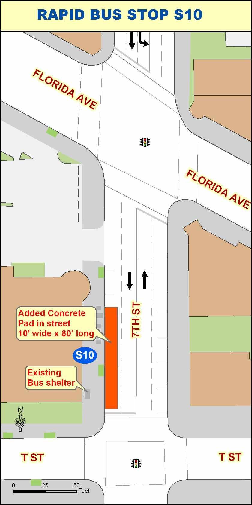
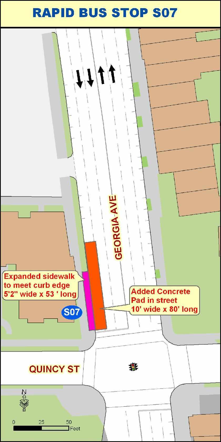
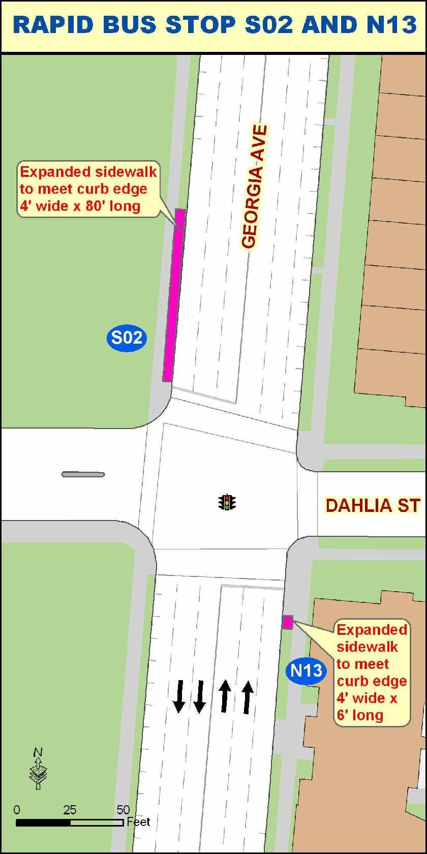
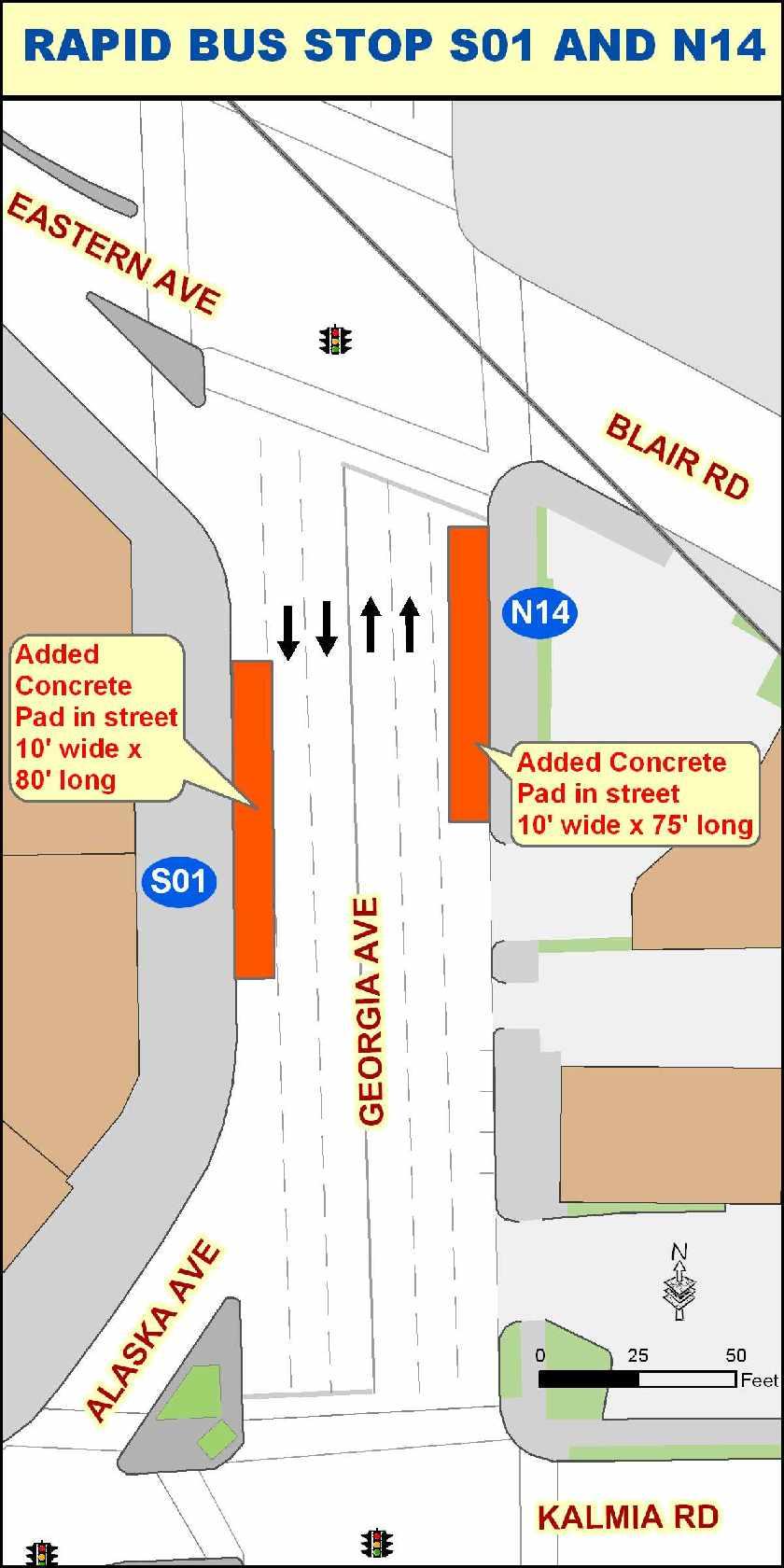
49 Appendix C Metro EXTRA Georgia Ave-7 th Street Corridor Requested DDOT Improvements at Rapid Bus Stop Locations 1

50 2
Mount Pleasant (42, 43) and Connecticut Avenue (L1, L2) Lines Service Evaluation Study Open House Welcome! wmata.com/bus
 and Connecticut Avenue (L1, L2) Lines Service Evaluation Study Open House Welcome! wmata.com/bus") Mount Pleasant (42, 43) and Connecticut Avenue (L1, L2) Lines Service Evaluation Study Open House Welcome! Study Overview and Timeline Phase 1: Collect and Analyze Data Project Kickoff, September 2017
Mount Pleasant (42, 43) and Connecticut Avenue (L1, L2) Lines Service Evaluation Study Open House Welcome! Study Overview and Timeline Phase 1: Collect and Analyze Data Project Kickoff, September 2017
Table of Contents. List of Tables
 Table of Contents 1. Introduction... 1 2. Service Recommendations... 1 A. Extend Service on Fort Belvoir to New Post Exchange/Commissary Complex... 1 B. Improve Service Frequencies on Sunday from Current
Interstate 90 and Mercer Island Mobility Study APRIL Commissioned by. Prepared by
 Interstate 90 and Mercer Island Mobility Study APRIL 2017 Commissioned by Prepared by Interstate 90 and Mercer Island Mobility Study Commissioned by: Sound Transit Prepared by: April 2017 Contents Section
METROBUS SERVICE GUIDELINES
 METROBUS SERVICE GUIDELINES In the late 1990's when stabilization of bus service was accomplished between WMATA and the local jurisdictional bus systems, the need for service planning processes and procedures
Washington Metropolitan Area Transit Authority Services Utilization Study
 Washington Metropolitan Area Transit Authority Services Utilization Study Maryland House Bill 300 Table of Contents Page 2 Executive Summary Slide 3 Notes Slide 4 Metro Systemwide Fact Sheet Slide 5 How
Background Information about the H Lines Evaluation
 Background Information about the H Lines Evaluation Questions H Lines Overview of Service Average number of daily riders Q. Why is this study being conducted? A. The H Lines consist of important cross-wn
ROUTE EBA EAST BUSWAY ALL STOPS ROUTE EBS EAST BUSWAY SHORT
 ROUTE EBA EAST BUSWAY ALL STOPS ROUTE EBS EAST BUSWAY SHORT The EBA East Busway All Stops and EBS East Busway Short routes provide the core Martin Luther King Jr. East Busway services. Route EBA operates
APPENDIX B. Arlington Transit Peer Review Technical Memorandum
 APPENDIX B Arlington Transit Peer Review Technical Memorandum Arlington County Appendix B December 2010 Table of Contents 1.0 OVERVIEW OF PEER ANALYSIS PROCESS... 2 1.1 National Transit Database...2 1.2
CHAPTER 5: Operations Plan
 CHAPTER 5: Operations Plan Report Prepared by: Contents 5 OPERATIONS PLAN... 5-1 5.1 Proposed Service Changes... 5-2 5.1.1 Fiscal Year 2017... 5-2 5.1.2 Fiscal Year 2018... 5-6 5.1.3 Fiscal Year 2019...
BOSTON REGION METROPOLITAN PLANNING ORGANIZATION
 PLANNING ORGANIZATIO BOSTON REGION MPO NMETROPOLITAN BOSTON REGION METROPOLITAN PLANNING ORGANIZATION Stephanie Pollack, MassDOT Secretary and CEO and MPO Chair Karl H. Quackenbush, Executive Director,
Date: 11/6/15. Total Passengers
 Total San Diego Metropolitan Transit System POLICY 42 PERFORMANCE MONITORING REPORT Page 1 of 6 OBJECTIVE Develop a Customer-Focused and Competitive System The following measures of productivity and service
SAN LUIS OBISPO TRANSIT + SAN LUIS OBISPO RTA JOINT SHORT RANGE TRANSIT PLANS: SERVICE STRATEGIES. Presented by: Gordon Shaw, PE, AICP; Principal
 SAN LUIS OBISPO TRANSIT + SAN LUIS OBISPO RTA JOINT SHORT RANGE TRANSIT PLANS: SERVICE STRATEGIES Presented by: Gordon Shaw, PE, AICP; Principal Project Status Review of existing services and setting complete
Madison Metro Transit System
 Madison Metro Transit System 1101 East Washington Avenue Madison, Wisconsin, 53703 Administrative Office: 608 266 4904 Fax: 608 267 8778 TO: FROM: SUBJECT: Plan Commission Timothy Sobota, Transit Planner,
5.1 Traffic and Transportation
 5.1 When it opens in 2009, the Bellevue Nickel Improvement Project will increase the number of vehicles able to travel through the study area, improve travel speeds, and improve safety by reducing the
A. CONCLUSIONS OF THE FGEIS
 Chapter 11: Traffic and Parking A. CONCLUSIONS OF THE FGEIS The FGEIS found that the Approved Plan will generate a substantial volume of vehicular and pedestrian activity, including an estimated 1,300
Appendix 4.1 J. May 17, 2010 Memorandum from CTPS to the Inter Agency Coordinating Group
 Appendix 4.1 J May 17, 2010 Memorandum from CTPS to the Inter Agency Coordinating Group CTPS CENTRAL TRANSPORTATION PLANNING STAFF Staff to the Boston Region Metropolitan Planning Organization MEMORANDUM
Att. A, AI 46, 11/9/17
 Total s San Diego Metropolitan Transit System POLICY 42 PERFORMANCE MONITORING REPORT Page 1 of 6 Date: 11/8/17 OBJECTIVE Develop a Customer-Focused and Competitive System The following measures of productivity
Metrobus Service Evaluations
 Metrobus Service Evaluations Routes B30, 87-88, & 89-89M Public Meeting Laurel Library May 25, 2011 Ben Schumin Purpose of the Evaluation Identify strategic needs; Review capacity, productivity, reliability,
These elements are designed to make service more convenient, connected, and memorable.
 Transit is most attractive when it is frequent enough that people don t need to consult a timetable, and can instead just go to a stop and know that the train or bus will arrive shortly. Nearly all major
KING STREET TRANSIT PILOT
 KING STREET TRANSIT PILOT Update toronto.ca/kingstreetpilot #kingstreetpilot HIGHLIGHTS TRANSIT RIDERSHIP TRANSIT CAPACITY To respond to this growth in ridership, the TTC has increased the capacity of
EXISTING CONDITIONS A. INTRODUCTION. Route 107 Corridor Study Report
 II. EXISTING CONDITIONS A. INTRODUCTION The Route 107 study area extends from the south at Chestnut Street in Lynn approximately 3.7 miles to the north to Boston Street in Salem. The study area has three
Bus Corridor Service Options
 Bus Corridor Service Options Outline Corridor Objectives and Strategies Express Local Limited Stop Overlay on Local Service 1 Deadhead 1 Stacey Schwarcz, "Service Design for Heavy Demand Corridors: Limited-Stop
7272 WISCONSIN AVENUE LOCAL AREA TRANSPORTATION REVIEW
 7272 LOCAL AREA TRANSPORTATION REVIEW AND TRANSPORTATION POLICY AREA REVIEW MONTGOMERY COUNTY, MARYLAND Submitted on behalf of Carr Properties Prepared by: Wells + Associates, Inc. Submission: July 1,
Treasure Island Supplemental Information Report Addendum
 1 1 1 1 0 1 0 1 0 1 Treasure Island Supplemental Information Report Addendum Introduction Purpose The purpose of this Supplemental Information Report (SIR) Addendum is to determine if the current land
SAMTRANS TITLE VI STANDARDS AND POLICIES
 SAMTRANS TITLE VI STANDARDS AND POLICIES Adopted March 13, 2013 Federal Title VI requirements of the Civil Rights Act of 1964 were recently updated by the Federal Transit Administration (FTA) and now require
EVALUATION OF TRANSIT SIGNAL PRIORITY EFFECTIVENESS USING AUTOMATIC VEHICLE LOCATION DATA
 EVALUATION OF TRANSIT SIGNAL PRIORITY EFFECTIVENESS USING AUTOMATIC VEHICLE LOCATION DATA A Thesis Presented to The Academic Faculty by Carl Andrew Sundstrom In Partial Fulfillment of the Requirements
rtc transit Before and After Studies for RTC Transit Boulder highway UPWP TASK Before Conditions
 rtc transit Before and After Studies for RTC Transit UPWP TASK 3403-11-14 Before Conditions Report Boulder highway June 2011 Before and After Studies for RTC Transit BOULDER HIGHWAY BEFORE STUDY UPWP Task
According to FAA Advisory Circular 150/5060-5, Airport Capacity and Delay, the elements that affect airfield capacity include:
 4.1 INTRODUCTION The previous chapters have described the existing facilities and provided planning guidelines as well as a forecast of demand for aviation activity at North Perry Airport. The demand/capacity
Corridor Analysis. Corridor Objectives and Strategies Express Local Limited Stop Overlay on Local Service 1 Deadhead
 Corridor Analysis Outline Corridor Objectives and Strategies Express Local Limited Stop Overlay on Local Service 1 Deadhead 1 Stacey Schwarcz, "Service Design for Heavy Demand Corridors: Limited-Stop Bus
3. Proposed Midwest Regional Rail System
 3. Proposed Midwest Regional Rail System 3.1 Introduction The proposed Midwest Regional Rail System (MWRRS) will operate in nine states, encompass approximately 3,000 route miles and operate on eight corridors.
TRANSPORTATION ELEMENT
 Transportation TRANSPORTATION ELEMENT Data, Inventory, and Analysis Prepared by Contents 1.0 INTRODUCTION... 1 2.0 EXISTING CONDITIONS... 1 2.1 Roadways... 1 2.1.1 Jurisdiction... 1 2.1.2 Functional Classification...
Silver Line Operating Plan
 Customer Service and Operations Committee Information Item IV-A December 6, 2012 Silver Line Operating Plan Washington Metropolitan Area Transit Authority Board Action/Information Summary Action Information
ROUTE 103. Morrisville Shopping Shuttle ROUTE OVERVIEW
 ROUTE 103 Morrisville Shopping Shuttle ROUTE OVERVIEW Route 103 is a Shuttle route that operates between Stowe and Morrisville. The route travels primarily along VT Route 100 and provides service to Stowe
DAILY TRIPS (LOOP) Monday-Friday 6:55 AM to 6:20 PM 60/60/ 11 Saturday 7:55 AM to 5:55 PM 60/ 10 Sunday
 Monday-Friday 6:55 AM to 6:20 PM 60/60/ 11 Saturday 7:55 AM to 5:55 PM 60/ 10 Sunday") ROUTE 81 BARRE HOSPITAL HILL ROUTE OVERVIEW Route 81 is a Rural Local route that operates between Downtown Barre and the Berlin Shaw s. The route travels outbound from downtown Barre along Airport Road
ROUTE 81 BARRE HOSPITAL HILL ROUTE OVERVIEW Route 81 is a Rural Local route that operates between Downtown Barre and the Berlin Shaw s. The route travels outbound from downtown Barre along Airport Road
Figure 1: Route 71A Negley
 ROUTE 71A NEGLEY Route 71A Negley is one of the strongest routes in the PAAC system, and provides service between Highland Park and Downtown Pittsburgh and Highland Park via Oakland, Shadyside, and East
APPENDIX B COMMUTER BUS FAREBOX POLICY PEER REVIEW
 APPENDIX B COMMUTER BUS FAREBOX POLICY PEER REVIEW APPENDIX B COMMUTER BUS FAREBOX POLICY PEER REVIEW The following pages are excerpts from a DRAFT-version Fare Analysis report conducted by Nelson\Nygaard
8 CROSS-BOUNDARY AGREEMENT WITH BRAMPTON TRANSIT
 8 CROSS-BOUNDARY AGREEMENT WITH BRAMPTON TRANSIT The Transportation Services Committee recommends the adoption of the recommendations contained in the following report dated May 27, 2010, from the Commissioner
PUBLIC TRANSIT IN KENOSHA, RACINE, AND MILWAUKEE COUNTIES
 PUBLIC TRANSIT IN KENOSHA, RACINE, AND MILWAUKEE COUNTIES #118404v1 Regional Transit Authority June 19, 2006 1 Presentation Overview Existing Public Transit Transit System Peer Comparison Recent Transit
MEMORANDUM. Lynn Hayes LSA Associates, Inc.
 MEMORANDUM To: Lynn Hayes LSA Associates, Inc. Date: May 5, 217 From: Zawwar Saiyed, P.E., Senior Transportation Engineer Justin Tucker, Transportation Engineer I Linscott, Law & Greenspan, Engineers LLG
PREFACE. Service frequency; Hours of service; Service coverage; Passenger loading; Reliability, and Transit vs. auto travel time.
 PREFACE The Florida Department of Transportation (FDOT) has embarked upon a statewide evaluation of transit system performance. The outcome of this evaluation is a benchmark of transit performance that
About This Report GAUGE INDICATOR. Red. Orange. Green. Gold
 ATTACHMENT A About This Report The Orange County Transportation Authority (OCTA) operates a countywide network of local, community, rail connector, and express bus routes serving over 6, bus stops. OCTA
DC Circulator Service Changes. Implementation Plan for June 24, 2018
 DC Circulator Service Changes Implementation Plan for June 24, 2018 Implementation Plan for June 24, 2018 Table of Contents 1.0 Overview of Service and Fare Changes... 5 1.1. Major Service Changes... 5
HOW TO IMPROVE HIGH-FREQUENCY BUS SERVICE RELIABILITY THROUGH SCHEDULING
 HOW TO IMPROVE HIGH-FREQUENCY BUS SERVICE RELIABILITY THROUGH SCHEDULING Ms. Grace Fattouche Abstract This paper outlines a scheduling process for improving high-frequency bus service reliability based
DEMOGRAPHICS AND EXISTING SERVICE
 EXECUTIVE SUMMARY The Central Corridor light-rail transit (LRT) project will open in 2014 and operate between downtown Minneapolis and downtown St. Paul, serving the University of Minnesota and University
CHAPTER 1 TRANSIT MARKET AREAS AND EXISTING SERVICE
 CHAPTER 1 TRANSIT MARKET AREAS AND EXISTING SERVICE Transit Market Areas While several factors influence the propensity to use transit, the primary predictors of transit productivity are the density of
This report recommends two new TTC transit services in southwest Toronto.
 Report for Action New TTC Services - Southwest Toronto Date: March 20, 2018 To: TTC Board From: Chief Customer Officer Summary This report recommends two new TTC transit services in southwest Toronto.
Table of Contents. List of Tables
 Table of Contents 1. Introduction... 1 2. Service Change Recommendations... 1 3. Passenger Facility Recommendations... 19 4. Traffic and ning Way Recommendations... 32 Appendix A... 40 Appendix B... 48
Quarterly Report Transit Bureau, Local Transit Operations. First Quarter, Fiscal Year 2015 (July 2014 September 2014) ART & STAR
 ART & STAR") Quarterly Report Transit Bureau, Local Transit Operations First Quarter, Fiscal Year 2015 (July 2014 September 2014) ART & STAR A Arlington Transit ART 1) Introduction The purpose of ART is to provide
Quarterly Report Transit Bureau, Local Transit Operations First Quarter, Fiscal Year 2015 (July 2014 September 2014) ART & STAR A Arlington Transit ART 1) Introduction The purpose of ART is to provide
CURRENT SHORT-RANGE TRANSIT PLANNING PRACTICE. 1. SRTP -- Definition & Introduction 2. Measures and Standards
 CURRENT SHORT-RANGE TRANSIT PLANNING PRACTICE Outline 1. SRTP -- Definition & Introduction 2. Measures and Standards 3. Current Practice in SRTP & Critique 1 Public Transport Planning A. Long Range (>
TABLE OF CONTENTS. Coral Springs Charter High School and Middle School Job No Page 2
 Job No. 15-019 Page 2 TABLE OF CONTENTS 1.0 INTRODUCTION... 4 2.0 EXISTING CONDITIONS... 5 3.0 TRAFFIC GENERATION... 7 4.0 TRIP DISTRIBUTION... 8 5.0 FUTURE CONDITIONS... 8 6.0 SITE ACCESS...13 7.0 CONCLUSION...13
APPENDIX H MILESTONE 2 TRAFFIC OPERATIONS ANALYSIS OF THE AT-GRADE CROSSINGS
 Draft Environmental Impact Statement/Environment Impact Report Appendix H Milestone 2 Traffic Operations Analysis of the At-Grade Crossings APPENDIX H MILESTONE 2 TRAFFIC OPERATIONS ANALYSIS OF THE AT-GRADE
Chapter 3. Burke & Company
 Chapter 3 Burke & Company 3. WRTA RIDERSHIP AND RIDERSHIP TRENDS 3.1 Service Overview The Worcester Regional Transit Authority (WRTA) provides transit service to over half a million people. The service
Memorandum. Roger Millar, Secretary of Transportation. Date: April 5, Interstate 90 Operations and Mercer Island Mobility
 Memorandum To: From: The Honorable Dow Constantine, King County Executive; The Honorable Ed Murray, City of Seattle Mayor; The Honorable Bruce Bassett, City of Mercer Island Mayor; The Honorable John Stokes,
Peer Performance Measurement February 2019 Prepared by the Division of Planning & Market Development
 2017 Regional Peer Review Peer Performance Measurement February 2019 Prepared by the Division of Planning & Market Development CONTENTS EXECUTIVE SUMMARY... 3 SNAPSHOT... 5 PEER SELECTION... 6 NOTES/METHODOLOGY...
City of Doral FIU Trolley Route Expansion Feasibility Study. David Plummer & Associates
 City of Doral FIU Trolley Route Expansion Feasibility Study David Plummer & Associates Prepared By: David Plummer & Associates Prepared For: City of Doral Prepared In: November 2017 D PA J o b # : 15211
ROUTE 61A EAST PITTSBURGH-WILKINSBURG
 ROUTE 61A EAST PITTSBURGH-WILKINSBURG Route 61A East Pittsburgh-Wilkinsburg is a radial route that operates between East Pittsburgh and downtown Pittsburgh via North Braddock, Swissvale and Edgewood, Wilkinsburg,
KING STREET TRANSIT PILOT
 KING STREET TRANSIT PILOT Update toronto.ca/kingstreetpilot #kingstreetpilot UPDATE Average streetcar travel times in continued to show similar trends as first observed in November. The most significant
Summary of Proposed NH 120 Service
 Proposed NH 120 Bus Route Moody Building Etna Road Summary of Proposed NH 120 Service The Upper Valley Lake Sunapee Regional Planning Commission (UVLSRPC) working together with a Steering Committee comprised
Metrobus Service Evaluation Study Bowie Lines Bowie State University (B21, 22) Bowie-Belair (B24, B25) Final Report June 2013
 Bowie-Belair (B24, B25) Final Report June 2013") Metrobus Service Evaluation Study Bowie Lines Bowie State University (B21, 22) Bowie-Belair (B24, B25) Final Report June 2013 Bowie-New Carrollton (B27) Crofton-New Carrollton (B29, B31) Study Purpose
Metrobus Service Evaluation Study Bowie Lines Bowie State University (B21, 22) Bowie-Belair (B24, B25) Final Report June 2013 Bowie-New Carrollton (B27) Crofton-New Carrollton (B29, B31) Study Purpose
1. PREVIOUS STUDIES/PLANNED DEVELOPMENTS... 1
 Contents 1. PREVIOUS STUDIES/PLANNED DEVELOPMENTS... 1 1.1 Purple Line Functional Plan... 1 1.2 Countywide Bus Rapid Transit Study... 2 1.3 Burtonsville Crossroads Neighborhood Plan... 3 1.4 Countywide
4. Proposed Transit Improvements
 4. Proposed Transit Improvements The following proposed transit improvements have been assembled based on input received from the community meetings and from review and coordination with the TAC as well
UNION STATION ACCESS AND CAPACITY IMPROVEMENT STUDY PROJECT REPORT
 UNION STATION ACCESS AND CAPACITY IMPROVEMENT STUDY PROJECT REPORT Washington Metropolitan Area Transit Authority Department of Planning and Joint Development In Association with District of Columbia Department
GREENBELT-BWI THURGOOD MARSHALL AIRPORT EXPRESS LINE ROUTE B30
 MARYLAND GREENBELT-BWI THURGOOD MARSHALL AIRPORT EXPRESS LINE ROUTE B30 BUDGET Cost neutral Option 1 Serve Arundel Mills Mall PROPOSED CHANGE Add service to Arundel Mills Mall on all trips. The time between
Potomac River Commuter Ferry Feasibility Study & RPE Results
 1.1 Introduction The Prince William County Department of Transportation conducted a route proving exercise (RPE) and feasibility study of a proposed commuter ferry service on the Potomac River between
Authors. Courtney Slavin Graduate Research Assistant Civil and Environmental Engineering Portland State University
 An Evaluation of the Impacts of an Adaptive Coordinated Traffic Signal System on Transit Performance: a case study on Powell Boulevard (Portland, Oregon) Authors Courtney Slavin Graduate Research Assistant
Figure 1: Route 56B Hazelwood
 ROUTE 56B HAZELWOOD Route 56B is a radial route that operates on weekdays between Homestead and downtown Pittsburgh. Traveling inbound, the route begins in Homestead at the Waterfront shopping center,
LUDWIG RD. SUBDIVISION PROJECT TRAFFIC IMPACT ANALYSIS
 LUDWIG RD. SUBDIVISION PROJECT TRAFFIC IMPACT ANALYSIS Prepared for Skip Coddington GSC Development, Inc PO Box 1623 Woodinville WA 9872 Prepared by 1141 NE 124 th St., #59 Kirkland, WA 9834 425.522.4118
Riders Advisory Council Rail Subcommittee April 9, 2008
 Riders Advisory Council Rail Subcommittee April 9, 2008 I. Call to Order/Roll Call: Mr. Cerny called the April meeting of the Riders Advisory Council s Metrorail Subcommittee to order at 7:06 p.m. The
WATERBORNE TRANSIT. April 21, 2010
 WATERBORNE TRANSIT CONCEPTS STUDY April 21, 2010 1 Overview: Summary of previous 2004/2005 Ferry Service analysis Results of recent study focusing on ferry service from Newport News Conclusions 2 2004/2005
LA Metro Rapid - Considerations in Identifying BRT Corridors. Martha Butler LACMTA, Transportation Planning Manager Los Angeles, California
 LA Metro Rapid - Considerations in Identifying BRT Corridors Martha Butler LACMTA, Transportation Planning Manager Los Angeles, California LA Metro Transportation planner/coordinator, designer, builder
City of Sacramento Sacramento Intermodal Transportation Facility Draft WP # 3 Transit Operational Requirements
 Sacramento Intermodal Transportation Facility Draft WP # 3 Transit Operational Requirements Contents 1 Introduction 1 2 Capitol Corridor Rail 3 2.1 Existing Operations 3 2.2 Future Plans 6 3 Amtrak Rail
Alternatives: Strategies for Transit Systems Change
 Alternatives: Strategies for Transit Systems Change There is a broad array of options for modification of transit operations to make it more cost effective and efficient. These are typically examined to
Mobile Farebox Repair Program: Setting Standards & Maximizing Regained Revenue
 Mobile Farebox Repair Program: Setting Standards & Maximizing Regained Revenue Michael J. Walk, Chief Performance Officer Larry Jackson, Directory of Treasury Maryland Transit Administration March 2012
Development of SH119 BRT Route Pattern Alternatives for Tier 2 - Service Level and BRT Route Pattern Alternatives
 Development of SH119 BRT Route Pattern Alternatives for Tier 2 - Service Level and BRT Route Pattern Alternatives June 1, 2018 Development of SH119 BRT Route Pattern Alternatives for Tier 2 - Service Level
Lessons Learned from Rebuilding the Muni Subway Schedule Leslie Bienenfeld
 Lessons Learned from Rebuilding the Muni Subway Schedule Leslie Bienenfeld Manager of Fixed Guideway Scheduling San Francisco Municipal Transportation Agency San Francisco, California SFMTA & the Municipal
2015 Independence Day Travel Overview U.S. Intercity Bus Industry
 2015 Independence Day Travel Overview U.S. Intercity Bus Industry Chaddick Institute for Metropolitan Development, DePaul University June 25, 2015 This Intercity Bus Briefing summarizes the Chaddick Institute
General Issues Committee Item Transit Operating Budget Ten Year Local Transit Strategy
 General Issues Committee Item 4.1 2017 Transit Operating Budget Ten Year Local Transit Strategy January 27, 2017 Presentation Outline 2017 Operating Budget Overview Ten Year Local Transit Strategy 2 2017
Appendix 1: Phase I Strategies
 Washington Metropolitan Area Transit Authority RTSP Presentation to the Technical Advisory Group January 19, 2012 Appendix 1: Phase I Strategies Base Case Definition MWCOG 2009 Adopted CLRP (2009-2030
Oakland A s Gondola Economic Impact
 January 2019 Oakland A s Gondola Economic Impact KEY FINDING: The proposed gondola system, which will connect the A s planned stadium to downtown Oakland, will generate $685 million in total economic benefit
FY Transit Needs Assessment. Ventura County Transportation Commission
 FY 18-19 Transit Needs Assessment Ventura County Transportation Commission Contents List of Figures and Appendices.. 2 Appendices... 1 Chapter 1: Introduction What is the Ventura County Transportation
Request to Improve Transit along the Dufferin Street Corridor
 For Action Request to Improve Transit along the Dufferin Street Corridor Date: July 10, 2018 To: TTC Board From: Chief Customer Officer Summary The 29 Dufferin bus route is one of the top five busiest
NORTH FRASER PERIMETER ROAD WEST CORRIDOR DEFINITION STUDY
 NORTH FRASER PERIMETER ROAD WEST CORRIDOR DEFINITION STUDY MAY 2011 SW1132SWD NORTH FRASER PERIMETER ROAD WEST CORRIDOR DEFINITION STUDY TABLE OF CONTENTS 1.0 INTRODUCTION... 1 2.0 CURRENT TRAVEL PATTERNS
Establishes a fare structure for Tacoma Link light rail, to be implemented in September 2014.
 RESOLUTION NO. R2013-24 Establish a Fare Structure and Fare Level for Tacoma Link MEETING: DATE: TYPE OF ACTION: STAFF CONTACT: PHONE: Board 09/26/2013 Final Action Ric Ilgenfritz, Executive Director,
PURPOSE AND NEED (CONCURRENCE POINT 1) NEW CANADA ROAD PROJECT FROM STATE ROUTE 1 (U.S. HIGHWAY 70) TO U.S. INTERSTATE 40
 NEW CANADA ROAD PROJECT FROM STATE ROUTE 1 (U.S. HIGHWAY 70) TO U.S. INTERSTATE 40") PURPOSE AND NEED (CONCURRENCE POINT 1) NEW CANADA ROAD PROJECT FROM STATE ROUTE 1 (U.S. HIGHWAY 70) TO U.S. INTERSTATE 40 Project Description The primary purpose of this project is to improve the major
PURPOSE AND NEED (CONCURRENCE POINT 1) NEW CANADA ROAD PROJECT FROM STATE ROUTE 1 (U.S. HIGHWAY 70) TO U.S. INTERSTATE 40 Project Description The primary purpose of this project is to improve the major
MEMORANDUM. Open Section Background. I-66 Open Section Study Area. VDOT Northern Virginia District. I-66 Project Team. Date: November 5, 2015
 MEMORANDUM To: VDOT Northern Virginia District From: I-66 Project Team Date: November 5, 2015 Subject: Open Section Background The purpose of this technical memorandum is to provide narrative and technical
DISTRICT EXPRESS LANES ANNUAL REPORT FISCAL YEAR 2017 JULY 1, 2016 JUNE 30, FloridaExpressLanes.com
 DISTRICT EXPRESS LANES ANNUAL REPORT FISCAL YEAR 2017 JULY 1, 2016 JUNE 30, 2017 FloridaExpressLanes.com This page intentionally left blank. TABLE OF CONTENTS List of Figures... ii List of Tables.... ii
PROPOSED FOR IMPLEMENTATION
 PROPOSED FOR IMPLEMENTATION Capital Transit Schedule & Route Revision Objective: Update the current Capital Transit schedules and routes to provide a higher level of reliability, add service to Riverside
All Door Boarding Title VI Service Fare Analysis. Appendix P.3
 All Door Boarding Title VI Service Fare Analysis Appendix P.3 Metro Board Report Los Angeles County Metropolitan Transportation Authority One Gateway Plaza 3rd Floor Board Room Los Angeles,
5 Rail demand in Western Sydney
 5 Rail demand in Western Sydney About this chapter To better understand where new or enhanced rail services are needed, this chapter presents an overview of the existing and future demand on the rail network
ADDISON COUNTY TRANSIT STUDY
 Prepared for Addison County Regional Planning Commission By Addison County Transit Resources Final Report June 2006 Prepared for Addison County Regional Planning Commission Addison County Transit Resources
Lake Erie Commerce Center Traffic Analysis
 LOCATION: East of NYS Route 5 at Bayview Road Town of Hamburg Erie County, New York PREPARED BY: Wendel Companies 140 John James Audubon Parkway Suite 200 Amherst, New York 14228 January 2012 i ii Table
APPENDIX 2 TORONTO TRANSIT COMMISSION SERVICE STANDARDS AND DECISION RULES FOR PLANNING TRANSIT SERVICE
 APPENDIX 2 TORONTO TRANSIT COMMISSION SERVICE STANDARDS AND DECISION RULES FOR PLANNING TRANSIT SERVICE Contents 1 Introduction... 1 2 Network Design Standards... 2 2.1 Transit Service Classifications...
Fewer air traffic delays in the summer of 2001
 June 21, 22 Fewer air traffic delays in the summer of 21 by Ken Lamon The MITRE Corporation Center for Advanced Aviation System Development T he FAA worries a lot about summer. Not only is summer the time
Exposition Corridor Transit Project Phase 2
 Exposition Metro Line Construction Authority Final Environmental Impact Report Technical Background Report FINAL Ridership Results Version 0.4 December 2009 Prepared for: Exposition Metro Line Construction
Comprehensive Operational Analysis
 June 2016 Revised August 2016 Comprehensive Operational Analysis of the Sarasota County Area Transit System Recommendations Report Sarasota County Area Transit Comprehensive Operations Analysis Technical
Section 106 Update Memo #1 Attachment D. Traffic Diversion & APE Expansion Methodology & Maps
 Section 106 Update Memo #1 Attachment D Traffic Diversion & APE Expansion Methodology & Maps I-65/I-70 North Split Interchange Reconstruction Project (Des. Nos. 1592385 & 1600808) Traffic Diversion and
Draft Concept Alternatives Analysis for the Inaugural Airport Program September 2005
 Draft Concept Alternatives Analysis for the Inaugural Airport Program September 2005 Section 3 - Refinement of the Ultimate Airfield Concept Using the Base Concept identified in Section 2, IDOT re-examined
FY Year End Performance Report
 Overall Ridership Big Blue Bus carried 18,748,869 passengers in FY2014-2015, a 0.3% reduction from the year prior. This negligible reduction in ridership represents the beginnings of a reversal from a
RULES AND REGULATIONS
 RULES AND REGULATIONS FOR METROBUS OPERATIONS OCTOBER 1996 (Revised by Board resolution February 10, 2000) Washington Metropolitan Area Transit Authority 600 Fifth Street, NW! Washington, DC 20001 PURPOSE
 REPORT TO THE BUSINESS ADMINISTRATION COMMITTEE PROPOSED AMENDMENT TO METROPOLITAN WASHINGTON AIRPORTS REGULATIONS ON TAXICAB DISPATCH FEE AT RONALD REAGAN WASHINGTON NATIONAL AIRPORT JANUARY 2009 ACTION