Western Development Lands Transportation Brief Richmond Village, (Ottawa), ON Mattamy Homes. Prepared By: Stantec Consulting Ltd.
|
|
|
- Opal Lyons
- 5 years ago
- Views:
Transcription
1 Western Development Lands Transportation Brief Richmond Village, (Ottawa), ON Mattamy Homes Prepared By: Stantec Consulting Ltd. March 2012
2 RICHMOND VILLAGE, OTTAWA, ON TRANSPORTATION BRIEF APRIL 2013 TIA GUIDELINES CHECKLIST TRANSPORTATION BRIEF Report Context Municipal Address Comment: Section 1.1 Location relative to major elements of the existing transportation system (e.g. the site is located in the southwest quadrant of the intersection of Main Street/First Street, 600m from the Maple Street Rapid Transit Station) Comment: Section 1.4 Existing land uses or permitted use provisions in the Official Plan, Zoning By-Law, etc. Comment: Section 1.4 Proposed land uses and relevant planning regulations to be used in the analysis Comment: Section 1.3 Proposed development size (building size, number of residential units, etc.) and location on site Comment: Section 1.4 Estimated date of occupancy Comment: Section 3.1 Planned phasing of development Comment: Section 3.1 Proposed number of parking spaces (not relevant for Registration of Plans of Subdivision) Comment: N/A Draft Plan of Subdivision Proposed access points and type of access (full turns, right-in/right-out, turning restrictions, etc.) Comment: Figure 9, Study area Comment: Figure 1 Time periods and phasing Comment: Section 1.3 Horizon years (including reference to phased development) Comment: Section 1.3 Existing Conditions Existing roads, ramps in the study area, including jurisdiction, classification, number of lanes and posted speed limit Comment: Section 2.1 Existing intersections, indicating type of control, lane configurations, turning restrictions and any other relevant data (e.g. extraordinary lane widths, grades, etc.) Comment: Section 2.1 Existing access points to adjacent developments (both sides of all roads bordering the site) Comment: Figure 3 Existing transit system, including stations and stops Comment: Section 2.2 Existing on- and off-road bicycle facilities and pedestrian sidewalks and pathway networks Comment: Section 2.3 Existing system operations (V/C, LOS) Comment: As per the pre-consultation, intersection capacity analysis was not required for this study Major trip generators/attractors within the study area should be indicated Comment: Section 2.4
3 RICHMOND VILLAGE, OTTAWA, ON TRANSPORTATION BRIEF APRIL 2013 Demand Forecasting Trip generation rates Comment: Section Impact Analysis Qualitative assessment of impacts on capacity; non-auto modes; on-site circulation; community Comment: Section 3.8, 3.9, 3.10 Mitigation Measures and Site Design Characteristics Location and timing of proposed changes to existing traffic controls at intersections (e.g. new traffic signals, Stop signs, etc.) Comment: Section 4.0 Mitigation measure required to offset impacts on the surface and Rapid Transit networks Comment: Section 4.0 New or modified elements of the bicycle and pedestrian networks Comment: Section 4.0 Community impact mitigation measures Comment: Section 4.0 Proposed TDM features or programs to support the site development. Comment: Section 4.0
4 WESTERN DEVELOPMENT LANDS TRANSPORTATION BRIEF RICHMOND VILLAGE, (OTTAWA), ON MARCH 2012 Table of Contents 1.0 INTRODUCTION PURPOSE CONTEXT SCOPE OF THE ASSESSMENT PROPOSED DEVELOPMENT EXISTING TRANSPORTATION ENVIRONMENT ROADS AND TRAFFIC CONTROL TRANSIT CYCLING AND WALKING EXISTING TRAFFIC VOLUMES FUTURE TRANSPORTATION CONDITIONS TRANSPORTATION NETWORK IMPROVMENTS FUTURE BACKGROUND CONDITIONS Future Background Growth Future Background Traffic Volumes MODE SHARE ASSUMPTIONS SITE TRAFFIC FORECASTS TRAFFIC DISTRIBUTION AND ASSIGNMENT TOTAL FUTURE CONDITIONS Site Access Locations / Intersections Signal Warrants All Way Stop Control Warrants Auxiliary Turning Lane Needs FUTURE CONDITIONS (5 YEARS BEYOND SITE BUILD-OUT) TRANSIT SERVICE CYCLING AND WALKING COMMUNITY IMPACTS TRANSPORTATION DEMAND MANAGEMENT SUMMARY AND CONCLUSIONS cm w:\active\ _richmondvillagedraftplantrafficimpactstudy\planning\report\richmond village tb draft v5.docx i
5 WESTERN DEVELOPMENT LANDS TRANSPORTATION BRIEF RICHMOND VILLAGE, (OTTAWA), ON MARCH 2012 List of Tables Table 1 Future Mode Share Assumptions (Peak Hour) Table 2 ITE Land Use Categories and Trip Rates Table 3 Site Traffic Generation Table 4 Traffic Distribution from the Kanata / Stittsville Traffic Zone List of Figures Figure 1 Location of Mattamy s Lands Figure 2 Site Concept Plan Figure 3 Existing Intersection Configuration Figure 4 Study Area Transit Routes Figure Existing Traffic Volumes Figure Future Background Traffic Volumes Figure 7 Site Traffic Assignment Figure Total Future Traffic Volumes Figure Future Intersection Configuration Figure Ultimate Future Traffic Volumes Appendices: Appendix A: Turning Movement Count Data Appendix B: Trip Generation Appendix C: Trip Distribution and Assignment Appendix D: Traffic Control and Auxiliary Lane Warrants cm w:\active\ _richmondvillagedraftplantrafficimpactstudy\planning\report\richmond village tb draft v5.docx E.ii
6 WESTERN DEVELOPMENT LANDS TRANSPORTATION BRIEF RICHMOND VILLAGE, (OTTAWA), ON MARCH INTRODUCTION 1.1 PURPOSE Stantec Consulting Ltd. was retained by Mattamy Homes to provide an assessment of the transportation needs and impacts related to the future build-out of a residential development known as the Western Development Lands at 6420 Ottawa Street and 6431 Ottawa Street. These properties are located in the south-western portion of the Village of Richmond, within the City of Ottawa. This study has been prepared in accordance with the City of Ottawa s Transportation Impact Guidelines, As part of the draft plan of subdivision application process, pre-consultation discussions were held with City of Ottawa staff where it was determined that a Transportation Brief (TB) would be required to support the application. This TB has been prepared to assess the potential transportation implications of the proposed residential subdivision and to determine whether transportation improvements are required to support it. 1.2 CONTEXT Mattamy Homes proposed community is located in the Rural Southwest area of the City of Ottawa. Figure 1 illustrates the location of Mattamy s proposed development at 6420 and 6431 Ottawa Street. To the north and east of the proposed development is the existing established community of Village of Richmond. To the immediate north of the subject site a development application has been submitted for a residential subdivision featuring approximately 1100 units. cm w:\active\ _richmondvillagedraftplantrafficimpactstudy\planning\report\richmond village tb draft v5.docx 1.1
, ON MARCH 2012 Figure 1 Location of Mattamy s Lands")
7 WESTERN DEVELOPMENT LANDS TRANSPORTATION BRIEF RICHMOND VILLAGE, (OTTAWA), ON MARCH 2012 Figure 1 Location of Mattamy s Lands NORTH Not to Scale cm w:\active\ _richmondvillagedraftplantrafficimpactstudy\planning\report\richmond village tb draft v5.docx 1.2
8 WESTERN DEVELOPMENT LANDS TRANSPORTATION BRIEF RICHMOND VILLAGE, (OTTAWA), ON MARCH SCOPE OF THE ASSESSMENT This TB has been carried out in accordance with the City of Ottawa Transportation Impact Assessment (TIA) Guidelines. During pre-consultation discussions with the City of Ottawa, the scope of this assessment was determined to include the following: Study area intersections to include: o o o o o o o o Perth Street at the proposed North South (N-S) Collector street Perth Street at Queen Charlotte Street Perth Street at McBean Street Perth Street at Huntley Road Perth Street at Fowler Street Perth Street at Fortune Street Ottawa Street at the proposed N-S Collector street Ottawa Street at a new site access (south of Ottawa Street) / west of N-S Collector Transportation horizon years to include: o o o o 2012 Existing Conditions 2023 Future Background Conditions 2023 Future Conditions (Full Build-Out) 2028 Ultimate Conditions (Full Build-Out plus 5 years) Analysis time periods to include the weekday AM and PM peak hours The methodology used in the TB is summarized below: The net increase in site traffic from the proposed development will be estimated Background traffic growth in the study area will be explicitly accounted for based on known developments in the study area cm w:\active\ _richmondvillagedraftplantrafficimpactstudy\planning\report\richmond village tb draft v5.docx 1.3
9 WESTERN DEVELOPMENT LANDS TRANSPORTATION BRIEF RICHMOND VILLAGE, (OTTAWA), ON MARCH 2012 A 2% per annum growth rate will be used to account for growth outside of the immediate study area. This rate is consistent with previous study area traffic assessments and is supported by the growth shown at the study area intersections The future background traffic volumes will be combined with the net increase in site traffic volumes to determine total future traffic volumes Ultimate traffic volumes will be determined by adding background growth to the total future traffic volumes The site accesses will be examined to determine if warrants are met for upgraded traffic controls and / or auxiliary lanes 1.4 PROPOSED DEVELOPMENT The proposed development is anticipated to consist of approximately 1100 units. The unit breakdown is anticipated to be comprised of approximately 100 townhome-style dwellings and roughly 1000 single family dwellings. The final number of residential units is subject to change as the plan is refined but these changes are not expected to be substantial. It has been assumed that development will proceed at a rate of approximately 135 units / year starting in 2015 and continuing until full build-out is achieved by Figure 2 shows the site concept plan for Mattamy s proposed development in the Village of Richmond. The development will be accessed by three new site access intersections including: Perth Street at the new North-South Collector (to be constructed as part of the new subdivision to the north) Ottawa Street at the new North-South (N-S) Collector Ottawa Street at a new access to the southern portion of the property In addition to the new access intersections, two new accesses will be created using existing roads to the east of the site including: Royal York Street Burke Street cm w:\active\ _richmondvillagedraftplantrafficimpactstudy\planning\report\richmond village tb draft v5.docx 1.4

10 WESTERN DEVELOPMENT LANDS TRANSPORTATION BRIEF RICHMOND VILLAGE, (OTTAWA), ON MARCH 2012 Figure 2 Site Concept Plan cm w:\active\ _richmondvillagedraftplantrafficimpactstudy\planning\report\richmond village tb draft v5.docx 1.5
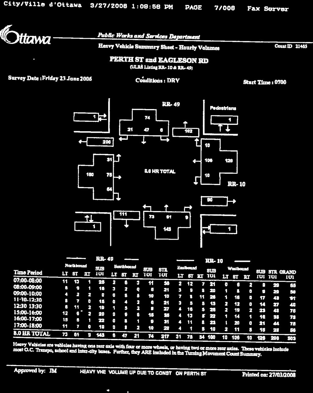
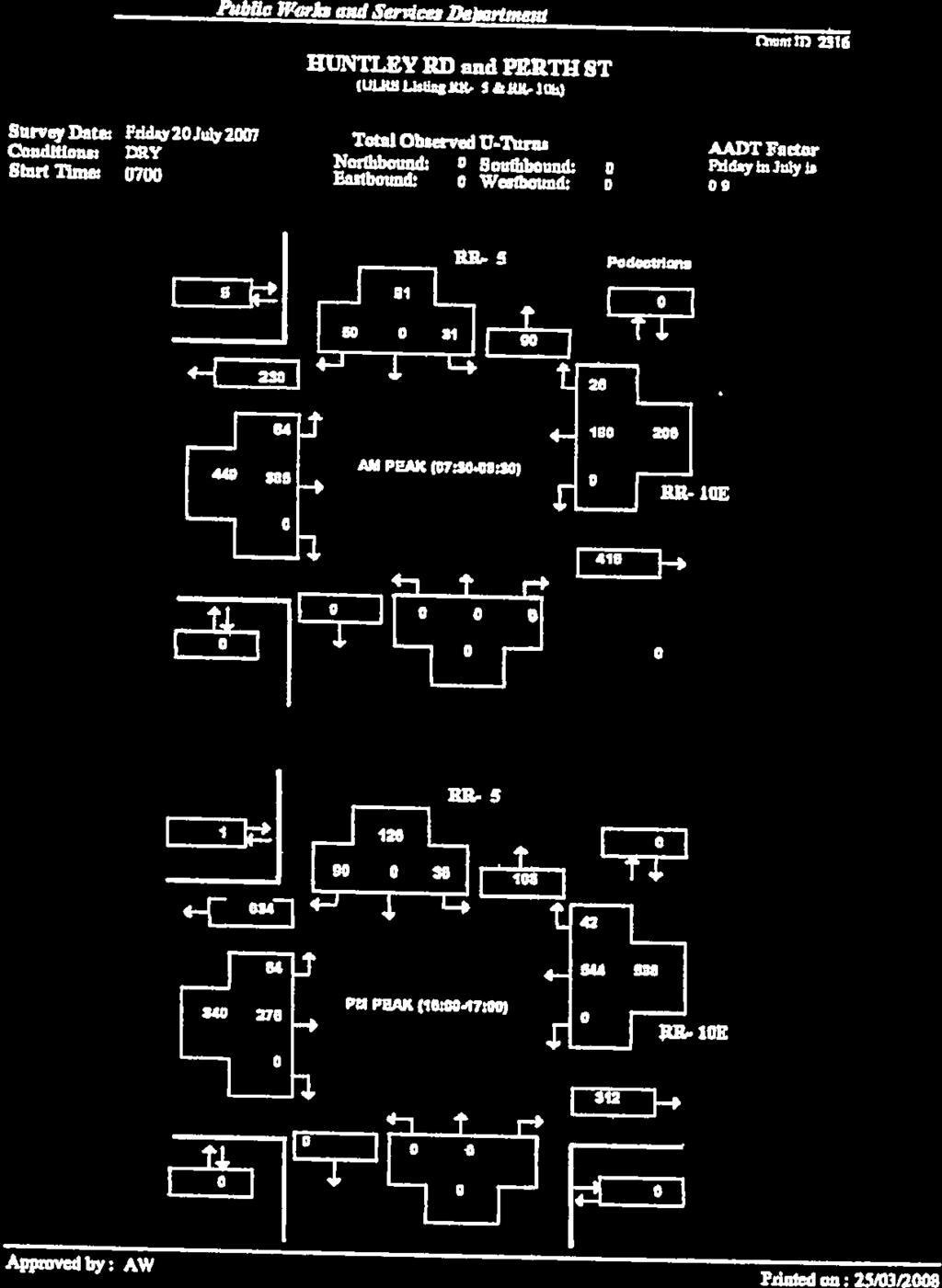
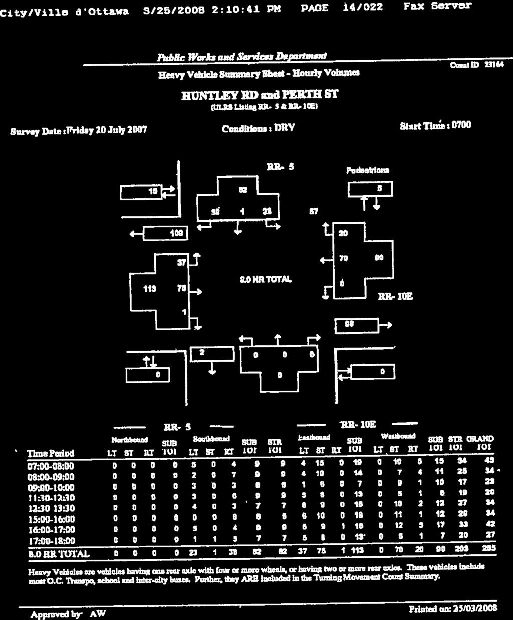
11 WESTERN DEVELOPMENT LANDS TRANSPORTATION BRIEF RICHMOND VILLAGE, (OTTAWA), ON MARCH EXISTING TRANSPORTATION ENVIRONMENT 2.1 ROADS AND TRAFFIC CONTROL The major roadways in the study area are described below: Perth Street / Franktown Road Running east west through the Village of Richmond, Perth Street is an undivided urban arterial road with a posted speed limit of 50 km/h. East of Queen Charlotte Street Perth Street has a four lane cross section. West of Queen Charlotte Street Perth Street becomes Franktown Road where it continues as a two lane rural arterial road. Perth Street features sidewalks on both sides of the road through the Village of Richmond, which end as the transition is made to Franktown Road and a rural cross-section. Ottawa Street is an east-west collector road with a rural cross-section and a 50 km/h posted speed limit. Ottawa Street does not currently have sidewalks. McBean Street McBean Street intersects Perth Street at a three way signalized intersection. It features a three-lane undivided cross-section at the intersection with Perth Street which includes an exclusive left turn lane. Sidewalks are provided on both sides of McBean Street within the Village of Richmond. McBean Street is designated as an arterial road with an urban cross-section and has a posted speed limit of 50 km/h. Huntley Road Huntley Road intersects Perth Street at a three way signalized intersection. It features a three-lane undivided cross-section at the intersection with Perth Street which includes an exclusive left turn lane. A sidewalk is provided on the west side of Huntley Road for approximately 100m north of Perth Street. Huntley Road is designated as an arterial road with a rural cross-section and has a posted speed limit of 50 km/h. The road classifications noted above are referenced from Map 6 of the City of Ottawa s Transportation Master Plan (TMP). Figure 3 illustrates the existing lane geometry and traffic controls at the study area intersections. cm w:\active\ _richmondvillagedraftplantrafficimpactstudy\planning\report\richmond village tb draft v5.docx 2.6


12 Perth Street and Queen Charlotte Street Perth Street and Fortune Street Perth Street and Fowler Street Perth Street and Huntley Road Perth Street and McBean Street Ottawa Street and Queen Charlotte Street Legend Future Lane Configuration Richmond Village Transportation Impact Study NORTH Not to Scale Mattamy Homes, City of Ottawa Existing Lane Configuration Figure 3 Existing Lane Configuration

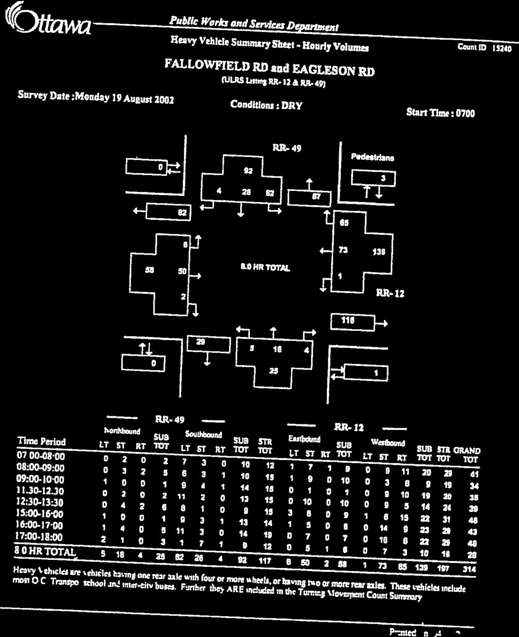
13 WESTERN DEVELOPMENT LANDS TRANSPORTATION BRIEF RICHMOND VILLAGE, (OTTAWA), ON MARCH TRANSIT Transit service is provided throughout the study area. The existing transit network includes routes along Perth Street, McBean Street and Huntley Road. Nearby transit routes include Route 201 and Route 283. Figure 4 illustrates the local transit routes. Figure 4 Study Area Transit Routes Source: OC Transpo System Map, Accessed December 11, 2012 ( cm w:\active\ _richmondvillagedraftplantrafficimpactstudy\planning\report\richmond village tb draft v5.docx 2.8
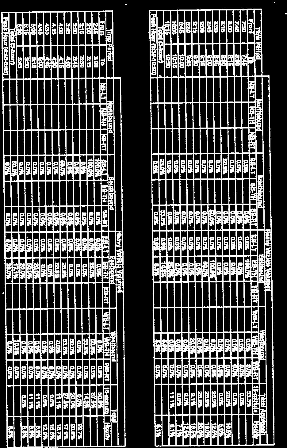
14 WESTERN DEVELOPMENT LANDS TRANSPORTATION BRIEF RICHMOND VILLAGE, (OTTAWA), ON MARCH CYCLING AND WALKING The study area contains existing cycling and pedestrian facilities. Perth Street and McBean Street each have sidewalks along both sides of the street. Huntley Road has a sidewalk along the west side which extends approximately 100m north of Perth Street. Throughout the residential areas and local streets of the Village of Richmond sidewalks are not generally provided given that the roads predominantly feature rural cross-sections. The Village of Richmond Transportation Master Plan, Figure 18, depicts Ottawa Street and Perth Street as designated on-road cycling route. Additionally, portions of Ottawa Street form part of the existing Rideau Trail network. This is consistent with Ottawa Cycling Plan (OCP), Figure 3-4b Network Concept. 2.4 EXISTING TRAFFIC VOLUMES Intersection turning movement counts were obtained from the City of Ottawa and supplemented with data from the Village of Richmond Transportation Master Plan and from traffic surveys undertaken by Stantec. Recent traffic data was acquired for the following intersections: Franktown Road and Fowler Street (2011) McBean Street and Perth Street (2011) Traffic count information was acquired from the Village of Richmond TMP for the following intersections: Huntley Road and Perth Street (2007) McBean Street and Perth Street (2007) Queen Charlotte Street and Perth Street (2008) Queen Charlotte Street and Ottawa Street (2008) A new traffic count was undertaken at the Queen Charlotte Street and Ottawa Street intersection in November of In the absence of turning movement count surveys at the Perth Street and Fortune Street intersection, traffic volumes at this location were estimated by reviewing the number of homes along Fortune Street and by applying industry standard trip generation rates from the Institute of Transportation Engineers Trip Generation Manual 9 th Edition. Traffic was assigned to the road network based on the distribution results of the 2005 O-D Survey. The trip distribution is further described in Section 3.5. Through volumes along Perth Street were obtained from the upstream and downstream intersections. Traffic volumes were balanced between intersections in locations where there were relatively low accesses or trip generators. All balancing was performed in a manner that favoured increasing volumes over decreasing volumes and, as a result, created a conservative estimate of the traffic volumes. cm w:\active\ _richmondvillagedraftplantrafficimpactstudy\planning\report\richmond village tb draft v5.docx 2.9
15 WESTERN DEVELOPMENT LANDS TRANSPORTATION BRIEF RICHMOND VILLAGE, (OTTAWA), ON MARCH 2012 Furthermore, existing turning movement count data that was collected prior to 2012 was adjusted to the current base year (2012) using a two percent per annum growth rate. Figure 5 illustrates existing AM and PM peak hour traffic volumes at the study area intersection. Traffic count data is provided for reference in Appendix A. cm w:\active\ _richmondvillagedraftplantrafficimpactstudy\planning\report\richmond village tb draft v5.docx 2.10
16 Perth Street and Queen Charlotte Street Burke Street and Fortune Street Perth Street and North South Collector (New) 200 (599) Ottawa Street and Site Access (New) NORTH Not to Scale Mattamy Homes, City of Ottawa 9 (4) 1 (0) 6 (9) Richmond Village Transportation Impact Study 9 (4) 7 (10) Ottawa Street and Queen Charlotte Street 1 (1) 1 (1) 9 (4) 7 (10) Ottawa Street and North - South Collector (New) 352 (249) 64 (64) 451 (293) 1 (3) 403 (289) 27 (95) 26 (42) 183 (544) Fortune Street and Royal York Street 1 (5) 190 (524) 42 (105) 108 (63) 34 (101) 11 (29) 407 (297) 7 (3) 17 (18) 1 (9) 3 (4) 63 (35) 4 (2) 6 (5) 0 (1) 2 (1) 369 (263) 1 (4) 11 (32) 210 (582) 4 (16) Perth Street and Huntley Road 31 (36) 50 (90) 202 (608) 14 (74) Perth Street and McBean Street 3 (5) 2 (3) 1 (4) 8 (12) 196 (595) 1 (3) Perth Street and Fowler Street 7 (71) 0 (7) 7 (82) 15 (14) 0 (3) 0 (1) 349 (247) 0 (1) Perth Street and Fortune Street Figure Existing Traffic
17 WESTERN DEVELOPMENT LANDS TRANSPORTATION BRIEF RICHMOND VILLAGE, (OTTAWA), ON MARCH FUTURE TRANSPORTATION CONDITIONS 3.1 TRANSPORTATION NETWORK IMPROVMENTS A review of the City of Ottawa TMP and the Village of Richmond TMP was undertaken to determine what improvements have been planned or examined previously to address existing or predicted deficiencies in the Village of Richmond traffic network. The City of Ottawa TMP does not list any upgrades to the transportation network in the Village of Richmond. The Village of Richmond TMP examined several upgrades to the transportation network. The primary examination was to determine the best solution to resolve anticipated east-west capacity issues. Three solutions were examined including: a new bridge across the Jock River at Ottawa Street; extending the four-lane cross-section of Perth Street to the western village limit; and an east-west village collector at the north end of the Village. The Village of Richmond TMP recommended that two of these solutions be carried forward, including the four-laning of Perth Street and the east-west collector. The bridge solution was not carried forward due to social and natural environment impacts and the low flexibility for future additional increases in capacity. Additional upgrades are recommended throughout the Village of Richmond that promote connectivity and accessibility but do not directly impact the subject site. Through the Community Design Plan and Village TMP process a roundabout is contemplated at the intersection of Perth Street and the proposed N-S Collector. The exact configuration of this roundabout will be determined through the future detail design but is intended to function as a means of controlling traffic and as a gateway feature. The operational analysis of this intersection, to be undertaken through future TIA s may also include recommended design features to accommodate the anticipated traffic demand at this intersection. A future multi-use path is shown in Figure 18 of the Village of Richmond TMP running along the Jock River and along Ottawa Street. Providing cycling facilities along the N-S Collector will connect the community to the planned facilities along Ottawa Street and promote active transportation throughout the proposed community FUTURE BACKGROUND CONDITIONS Future background conditions are assessed to determine transportation improvements that may be required to address growth in traffic exclusive from improvements that may be required to accommodate traffic generated by the subject development. Any improvements identified to address future background conditions are not the responsibility of the proponent of the subject site Future Background Growth Future background conditions are typically derived by calculating the annual rate of growth on a transportation facility through a review of historic traffic volumes and / or by accounting for traffic cm w:\active\ _richmondvillagedraftplantrafficimpactstudy\planning\report\richmond village tb draft v5.docx 3.12
18 WESTERN DEVELOPMENT LANDS TRANSPORTATION BRIEF RICHMOND VILLAGE, (OTTAWA), ON MARCH 2012 generated by other known area developments that were recently approved or that are currently in the planning approvals process. By examining historic traffic volumes at the study area intersections a growth rate of approximately 2% was determined to be appropriate. This is consistent with previously approved TIA s and the Village of Richmond TMP. The growth rate of 2% / annum was applied to existing traffic volumes at the study area intersections until the 2023 future horizon. This background growth rate was applied to the arterial road through volumes and all turning movements at arterial / arterial intersections. By 2023 the development to the north of Mattamy s proposed site (Richmond Village [South] Limited) is anticipated to be fully built-out. Site trips generated by this background development were taken from the Village of Richmond Transportation Brief, GENIVAR August 2012, and were explicitly added to the transportation network Future Background Traffic Volumes Future background growth assumptions, detailed in Section 3.2.1, were applied to the existing traffic volumes to predict future background traffic volumes. Figure 6 depicts the future background traffic volumes anticipated at the study area intersections. To serve the background development it is anticipated that a roundabout will be implemented at the intersection of Perth Street and the new N-S Collector street. By this horizon it is anticipated that the fourlaning of Perth Street will also be required to accommodate the predicted volumes. Additionally, the roundabout at Perth Street and the new site access will be constructed before The link volumes on Perth Street, between Queen Charlotte Street and the N-S Collector are projected to exceed the capacity of a two-lane arterial road (i.e. approximately 1100 vehicles per hour versus an existing capacity of 900 vehicle per hour). This indicates that the widening of Perth Street to four lanes will be required to accommodate 2023 future background volumes. cm w:\active\ _richmondvillagedraftplantrafficimpactstudy\planning\report\richmond village tb draft v5.docx 3.13
19 Perth Street and Queen Charlotte Street Burke Street and Fortune Street Perth Street and North South Collector (New) 125 (70) 25 (15) 40 (125) 245 (730) 80 (250) Ottawa Street and Site Access (New) NORTH Not to Scale Mattamy Homes, City of Ottawa 10 (5) 5 (10) Richmond Village Transportation Impact Study 10 (5) 5 (10) Ottawa Street and Queen Charlotte Street 10 (5) 5 (10) Ottawa Street and North - South Collector (New) 255 (140) 55 (30) 10 (25) 430 (305) 20 (55) 125 (105) 850 (525) 0 (5) 835 (545) 65 (135) 25 (40) 320 (960) Fortune Street and Royal York Street 0 (5) 345 (980) 50 (130) 130 (75) 50 (155) 10 (30) 875 (570) 15 (20) 0 (10) 75 (45) 830 (530) 0 (5) 10 (30) 380 (1080) 5 (15) Perth Street and Huntley Road 40 (45) 75 (155) 370 (1115) 15 (75) Perth Street and McBean Street 0 (5) 0 (5) 10 (10) 360 (1100) 0 (5) Perth Street and Fowler Street 5 (70) 0 (5) 5 (80) 15 (15) 0 (5) 805 (510) Perth Street and Fortune Street Figure Future Background Traffic
20 WESTERN DEVELOPMENT LANDS TRANSPORTATION BRIEF RICHMOND VILLAGE, (OTTAWA), ON MARCH MODE SHARE ASSUMPTIONS The TRANS Committee s 2005 Origin Destination (O-D) Survey for the National Capital Region was reviewed to ascertain the existing mode share characteristics for the Rural Southwest traffic zone. All trips for the Other mode listed in the O-D Survey were added to the auto mode share to ensure a conservative approach. The mode share for trips within the district and outside the district were combined to derive an estimated mode share for the new community. Table 1 summarizes the peak hour mode share assumptions applied in this study. Table 1 Future Mode Share Assumptions (Peak Hour) Mode AM PM Auto 85% 79% Passenger 10% 15% Transit 3% 3% Active Mode 2% 3% 3.4 SITE TRAFFIC FORECASTS To determine the transportation impacts of a new development it is necessary to estimate the additional demand that will be placed on the transportation network. It is becoming common practice to first estimate the volume of person trips generated by a given development and then allocate these trips to the various modes of transportation. To determine the number of peak hour person trips expected to be generated by the development the Institute of Transportation Engineers (ITE) Trip Generation Manual, 9 th Edition was used as a basis for estimating the volume of automobile trips. Table 2 summarizes the base automobile trip generation characteristics of the proposed development. These rates are obtained using the equations listed in ITE Trip Generation Manual and are based on the approximate number of units and unit types that are anticipated in Mattamy s subdivision. Table 2 ITE Land Use Categories and Trip Rates Land Use Units Morning Peak Hour Afternoon Peak Hour Inbound Outbound Rate Inbound Outbound Rate Single Family Detached (210) % 75% % 37% 0.84 Residential Condominium / Townhouse (230) 99 17% 83% % 33% 0.60 cm w:\active\ _richmondvillagedraftplantrafficimpactstudy\planning\report\richmond village tb draft v5.docx 3.15
21 WESTERN DEVELOPMENT LANDS TRANSPORTATION BRIEF RICHMOND VILLAGE, (OTTAWA), ON MARCH 2012 Utilizing the above trip rates the base ITE automobile trips were generated. Converting these automobile trips to person trips is done as follows: As a general rule, the ITE trip generation rates are assumed to include an inherent 10% transit modal share. To account for this in the conversion to person trips the base ITE automobile trips were increased by 10%. An auto-occupancy factor is applied to the base ITE rates to account for auto passengers. Through the TRANS O-D Survey it was determined that for the study area 10% of AM peak hour trips and 15% of PM peak hour trips are automobile passenger trips. To reflect the auto-occupancy the trips generated were increase by 10% in the AM peak hour and 15% in the PM peak hour. By accounting for both the inherent transit mode share and the anticipated auto-occupancy the base ITE automobile trips were converted to person trips. The person trips are then assigned to the various transportation modes using the modes shares summarized in Section 3.3. Table 3 summarizes the person trips by mode as well as the inbound or outbound splits for the morning and afternoon peak hours. To simplify the trip generation and distribution the site was analyzed in two sections, one to the north of Ottawa Street and the second to the south of Ottawa Street. As shown in Table 3 the development is expected to generate approximately 900 person trips during the AM peak hour and roughly 1150 person trips during the PM peak hour. Similarly, the site is expected to generate roughly 800 automobile trips during the AM peak hour and 900 automobile trips during the PM peak hour. Appendix B contains detailed trip generation information. cm w:\active\ _richmondvillagedraftplantrafficimpactstudy\planning\report\richmond village tb draft v5.docx 3.16
22 WESTERN DEVELOPMENT LANDS TRANSPORTATION BRIEF RICHMOND VILLAGE, (OTTAWA), ON MARCH 2012 Table 3 Site Traffic Generation Zone Factors Modes Split Morning Peak Hour Afternoon Peak Hour Split In Out Total In Out Total Adjustment Factors Mattamy North Mattamy South Total Site Trips Base ITE Trips Inherent Transit Mode Share 10% % Auto Occupancy 10% % Total Person Trips Site Trips by Travel Mode Auto 85% % Passenger 10% % Transit 3% % Active Mode 2% % Adjustment Factors Base ITE Trips Inherent Transit Mode Share 10% % Auto Occupancy 10% % Total Person Trips Site Trips by Travel Mode Auto 85% % Passenger 10% % Transit 3% % Active Mode 2% % Adjustment Factors Base ITE Trips Inherent Transit Mode Share 10% % Auto Occupancy 10% % Total Person Trips Site Trips by Travel Mode Auto 85% % Passenger 10% % Transit 3% % Active Mode 2% % cm w:\active\ _richmondvillagedraftplantrafficimpactstudy\planning\report\richmond village tb draft v5.docx 3.17
23 WESTERN DEVELOPMENT LANDS TRANSPORTATION BRIEF RICHMOND VILLAGE, (OTTAWA), ON MARCH TRAFFIC DISTRIBUTION AND ASSIGNMENT The distribution of traffic to/from the study area was determined through examination of the TRANS Committee s 2005 Origin-Destination (O-D) Survey. Table 4 provides a summary of the distribution of traffic from the site across the four cardinal directions. Table 4 Traffic Distribution from the Kanata / Stittsville Traffic Zone Cardinal Direction Assignment North 60% South 5% East 30% West 5% Appendix C provides a detailed summary of the trip distribution and assignment. Site trips were assigned to the road network based on the location of each site access relative to the proximity of collector and arterial roads and proposed intersections along the boundary road network. Figure 7 illustrates the assignment of site traffic to the boundary road network and study area intersections. cm w:\active\ _richmondvillagedraftplantrafficimpactstudy\planning\report\richmond village tb draft v5.docx 3.18
24 Perth Street and Queen Charlotte Street 17 (10) 15 (8) Burke Street and Fortune Street Perth Street and North South Collector (New) 18 (52) 5 (17) 147 (440) Ottawa Street and Site Access (New) NORTH Not to Scale Mattamy Homes, City of Ottawa 53 (30) 18 (52) Richmond Village Transportation Impact Study 22 (12) 115 (66) 6 (3) 91 (52) 6 (3) 80 (52) 14 (8) 2 (6) 5 (17) 5 (14) 7 (21) Ottawa Street and Queen Charlotte Street 17 (10) 39 (112) 34 (80) 5 (14) 2 (6) 15 (8) 31 (89) Ottawa Street and North - South Collector (New) 53 (30) 17 (10) 454 (255) 9 (5) 3 (8) 5 (14) 71 (40) 29 (16) 498 (280) 527 (296) 15 (8) 161 (483) Fortune Street and Royal York Street 23 (68) 5 (17) 171 (511) 5 (14) 542 (304) 88 (49) 454 (255) 175 (525) Perth Street and Huntley Road 9 (28) 147 (440) 28 (85) Perth Street and McBean Street 147 (440) Perth Street and Fowler Street 454 (255) Perth Street and Fortune Street Figure 7 Site Generated Traffic
25 WESTERN DEVELOPMENT LANDS TRANSPORTATION BRIEF RICHMOND VILLAGE, (OTTAWA), ON MARCH TOTAL FUTURE CONDITIONS Total future conditions are examined to determine improvements that may be required as a direct result of the development of the site. It is anticipated that by 2023, all of the residential units within Mattamy s proposed development will be built and occupied. Total future traffic volumes are derived by adding site generated trips (Figure 7) to future background volumes (Figure 6) anticipated for Figure 8 illustrates 2023 total future traffic volumes at the study area intersections. The projected volume of traffic along Perth Street can be accommodated with the widening of Perth Street to a four-lane cross-section (identified to accommodate future background traffic volumes). Detailed operational analysis of these intersections will be undertaken in subsequent TIA s submitted for each development phase. The operational performance of the site access or study area intersections, including the future roundabout at Perth Street and the N-S Collector, will be examined and addressed through the subsequent TIA s Site Access Locations / Intersections As depicted earlier in Figure 2, the development will feature a N-S Collector road which will provide direct access to the community and will distribute trips to the internal subdivision streets and residential driveways. The N-S Collector will ultimately extend north of Perth Street and south of Ottawa Street. The portion of Mattamy s development north of Ottawa Street will be accessed as follows: Perth Street / N-S Collector via extension of the N-S Collector through the development lands of Richmond Village (South) Limited Ottawa Street / N-S Collector Burke Street Extension Royal York Street Extension The portion of Mattamy s development south of Ottawa Street will be accessed as follows: Ottawa Street / N-S Collector Ottawa Street / New site access west of N-S Collector Signal Warrants Ministry of Transportation Ontario (MTO) traffic signal warrants were examined at the Ottawa Street / N-S Collector intersection. It was found that signals are not warranted at this location during the 2023 total future horizon. The intersection of Ottawa Street / New site access west of the N-S Collector was not explicitly examined using MTO s signal warrant calculation. However, based on the results of the signal cm w:\active\ _richmondvillagedraftplantrafficimpactstudy\planning\report\richmond village tb draft v5.docx 3.20
26 WESTERN DEVELOPMENT LANDS TRANSPORTATION BRIEF RICHMOND VILLAGE, (OTTAWA), ON MARCH 2012 warrant examination at Ottawa Street / N-S Collector and a comparison of the volumes between the two intersections, a signal will not be required at Ottawa Street / New site access west of the N-S Collector. A signal warrant analysis was not performed at the intersection of Perth Street and the N-S Collector given that a roundabout has been recommended at this location through previous planning documents. Appendix D contains the detailed signal warrant All Way Stop Control Warrants As signals are not anticipated at either of the new intersections along Ottawa Street the implementation of an all way stop control (AWSC) was examined. Both intersections were examined using the City of Ottawa s AWSC procedure. It was determined that an AWSC will likely be required at the intersection of Ottawa Street and the N-S Collector street. However, an AWSC is not required at the intersection of Ottawa Street and the new site access west of the N-S Collector. As with the signal warrants the intersection of Perth Street and the N-S Collector was not examined as a roundabout has been assumed at this location. Appendix D contains detailed warrant calculations Auxiliary Turning Lane Needs The need for auxiliary turning lane was examined to ensure that intersections can safely accommodate the anticipated turning movement volumes. At unsignalized intersections right turn lanes are considered when the volume of decelerating or accelerating vehicles compared with the through traffic volume causes undue hazard (Transportation Association of Canada Geometric Design Guide for Canadian Roads, Section ). Given that an AWSC is warranted at the intersection of Ottawa Street and the N-S Collector it is unlikely that an undue hazard will be created at this location. MTO s Geometric Design Guide was used to examine left turn lane warrants. It was determined that left turn lanes are not warranted at the intersection of Ottawa Street and the N-S Collector. The need for right and left auxiliary turning lanes was also examined at the intersection of Ottawa Street and the new site access. This examination determined that auxiliary lanes are not warranted at this intersection. Appendix D contains detailed warrant calculations. Figure 9 details the anticipated future lane configuration and traffic controls for the study area intersections based on the results of the above sections. cm w:\active\ _richmondvillagedraftplantrafficimpactstudy\planning\report\richmond village tb draft v5.docx 3.21
27 Perth Street and Queen Charlotte Street 15 (10) 15 (10) Burke Street and Fortune Street Perth Street and North South Collector (New) 20 (50) 5 (15) 125 (70) 25 (15) 40 (125) 245 (730) 230 (690) Ottawa Street and Site Access (New) NORTH Not to Scale Mattamy Homes, City of Ottawa 60 (35) 25 (60) Richmond Village Transportation Impact Study 20 (10) 115 (65) 90 (50) 80 (50) 25 (10) 5 (15) 10 (25) 5 (20) Ottawa Street and Queen Charlotte Street 15 (10) 40 (110) 35 (80) 15 (20) 20 (20) 30 (90) Ottawa Street and North - South Collector (New) 55 (30) 15 (10) 705 (395) 65 (35) 10 (25) 430 (305) 20 (65) 5 (15) 70 (40) 150 (120) 1350 (805) 1365 (840) 80 (140) 25 (40) 480 (1440) Fortune Street and Royal York Street 25 (70) 5 (15) 515 (1490) 50 (130) 130 (75) 55 (170) 10 (30) 1415 (875) 15 (20) 5 (10) 165 (90) 1280 (785) 10 (30) 555 (1610) 5 (15) Perth Street and Huntley Road 40 (45) 85 (185) 515 (1555) 45 (160) Perth Street and McBean Street 10 (10) 510 (1540) Perth Street and Fowler Street 5 (70) 5 (80) 15 (15) 1255 (765) Perth Street and Fortune Street Figure Future Traffic
28 Perth Street and Queen Charlotte Street Perth Street and Fortune Street Perth Street and Fowler Street Perth Street and Huntley Road Perth Street and McBean Street Perth Street and North South Collector (New) Ottawa Street and Site Access (New) Ottawa Street and North - South Collector (New) Ottawa Street and Queen Charlotte Street Legend Future Lane Configuration Richmond Village Transportation Impact Study NORTH Not to Scale Mattamy Homes, City of Ottawa Existing Lane Configuration Figure 9 Future Lane Configuration
29 WESTERN DEVELOPMENT LANDS TRANSPORTATION BRIEF RICHMOND VILLAGE, (OTTAWA), ON MARCH FUTURE CONDITIONS (5 YEARS BEYOND SITE BUILD-OUT) The City of Ottawa s TIA Guidelines require an assessment of transportation conditions five years beyond the build-out of a given site. Ultimate future conditions for the 2028 horizon were examined to determine if other improvements may be required due to continued background growth. Traffic volumes for the 2028 horizon are derived by adding anticipated growth that may occur between the site build-out horizon (i.e. 2023) and the ultimate horizon. This growth includes a 2 percent annual growth rate. Figure 10 illustrates 2028 ultimate future traffic volumes at the study area intersections. As volumes have not significantly increased at the site accesses between 2023 and 2028 none of the traffic control or auxiliary lanes are anticipated to change. No modifications to the site access will be required to accommodate background growth 5 years beyond the full build out of the proposed development. An operational analysis of these intersections will be undertaken in subsequent TIA s submitted for each development phase. Any operational constraints at the site access or study area intersections, including the future roundabout at Perth Street and the N-S Collector, will be examined and addressed through the subsequent TIA s. cm w:\active\ _richmondvillagedraftplantrafficimpactstudy\planning\report\richmond village tb draft v5.docx 3.24
30 Perth Street and Queen Charlotte Street 15 (10) 15 (10) Burke Street and Fortune Street Perth Street and North South Collector (New) 20 (50) 5 (15) 125 (70) 25 (15) 40 (125) 265 (790) 230 (690) Ottawa Street and Site Access (New) NORTH Not to Scale Mattamy Homes, City of Ottawa 60 (35) 25 (60) Richmond Village Transportation Impact Study 20 (10) 115 (65) 90 (50) 80 (50) 25 (10) 5 (15) 10 (25) 5 (20) Ottawa Street and Queen Charlotte Street 15 (10) 40 (110) 35 (80) 15 (20) 20 (20) 30 (90) Ottawa Street and North - South Collector (New) 55 (30) 15 (10) 705 (395) 65 (35) 10 (25) 465 (330) 20 (65) 5 (15) 70 (40) 160 (125) 1395 (830) 1405 (870) 85 (150) 25 (40) 500 (1495) Fortune Street and Royal York Street 25 (70) 5 (15) 535 (1545) 55 (140) 145 (85) 60 (180) 10 (30) 1455 (905) 15 (20) 5 (10) 170 (95) 1320 (810) 10 (30) 575 (1665) 5 (15) Perth Street and Huntley Road 40 (50) 90 (190) 535 (1615) 45 (160) Perth Street and McBean Street 10 (10) 530 (1600) 0 (5) Perth Street and Fowler Street 5 (70) 5 (80) 15 (15) 1290 (790) Perth Street and Fortune Street Figure Ultimate Traffic
31 WESTERN DEVELOPMENT LANDS TRANSPORTATION BRIEF RICHMOND VILLAGE, (OTTAWA), ON MARCH TRANSIT SERVICE The availability of transit service is largely dependent on the financial viability of operating additional routes and services to an area. While the Village of Richmond is currently only serviced by express routes during peak hours, the addition of more potential customers will allow OCTranspo to expand the services currently offered. With the addition of the proposed development existing transit routes should be reconfigured to serve the new community. The proposed N-S Collector provides an ideal location for an additional loop to the existing Route CYCLING AND WALKING In accordance with Ottawa s Pedestrian Plan, sidewalks should be provided along both sides of collector streets and, where deemed appropriate, along one side of local streets. The width of sidewalks and boulevards should generally adhere to the recommendations of the Ottawa Pedestrian Plan June 2009 (OPP) and should be coordinated with the surrounding developments to ensure connectivity and consistency in design. The N-S Collector should be designated as a cycling route as it will provide access to a school and two parks. Furthermore, as a cycling route the N-S Collector provides continuity and connectivity to Perth Street and Ottawa Street both of which are designated as cycling routes. In addition, the site plan should allow for connections to be made to the pathway system and recreational areas along the Jock River COMMUNITY IMPACTS The proposed road network, and the orientation of the N-S Collector, will direct the majority of site trips to the arterial road network (i.e. Perth Street). Some site trips will, however, utilize Fortune Street to access the broader network expected to be less than 100 peak direction trips - given the direct connections made through the extensions of Burke Street and Royal York Street to the subject site. The impact of these site trips on the existing community is expected to be negligible TRANSPORTATION DEMAND MANAGEMENT As the proposed development is a rural residential subdivision no specific Transportation Demand Management initiatives have been considered. cm w:\active\ _richmondvillagedraftplantrafficimpactstudy\planning\report\richmond village tb draft v5.docx 3.26
32 WESTERN DEVELOPMENT LANDS TRANSPORTATION BRIEF RICHMOND VILLAGE, (OTTAWA), ON MARCH SUMMARY AND CONCLUSIONS The Transportation Brief has found the following: Mattamy s proposed development at 6420 and 6431 Ottawa Street will feature approximately 1100 residential units. Roughly 1000 of these units will be single family dwellings and 100 units will be townhome-style dwellings. The proposed development is expected to generate approximately 900 person trips during the AM peak hour and roughly 1150 person trips during the PM peak hour. Similarly, the site is expected to generate roughly 800 automobile trips during the AM peak hour and 900 automobile trips during the PM peak hour. The site will be accessed at two new intersections, two existing roads along the east edge and through the proposed development to the north of the proposed development. With the addition of the proposed development existing transit routes should be reconfigured to serve the new community. The proposed N-S Collector provides an ideal location for an additional loop to the existing Route 283. Sidewalks should be provided along both sides of the subdivision collector streets and, where deemed appropriate, on one side of local streets. The N-S Collector should be designated as a cycling route as it will provide access to a school and two parks and because it provides continuity and connectivity to the existing network. The site plan should allow for connections to be made to the pathway system and recreational areas along the Jock River. To support development in the west end of the Village of Richmond the four lane crosssection of Perth Street should be extended to at least the intersection of Perth Street and the new N-S Collector. This improvement is consistent with the recommendations of the Village of Richmond Transportation Master Plan. At full build-out of the proposed development, anticipated in approximately 2023, an all-way stop control has been shown to be warranted at the intersection of the new N-S Collector and Ottawa Street. The timing of and need for the AWSC will be confirmed through TIA s for each development phase. The site access intersection to Ottawa Street (west of the N-S Collector) should be stopcontrolled on the minor approach (i.e. site access approach). It is not anticipated that additional lanes will be required at this new access. cm w:\active\ _richmondvillagedraftplantrafficimpactstudy\planning\report\richmond village tb draft v5.docx 4.27
33 WESTERN DEVELOPMENT LANDS TRANSPORTATION BRIEF RICHMOND VILLAGE, (OTTAWA), ON MARCH 2012 While some site trips are expected to utilize Fortune Street, Burke Street and Royal York Street, the impact of these site trips on the existing community is expected to be negligible. The operational characteristics of the study area intersections will be examined in subsequent TIA s for each development phase. Based on the transportation evaluation and the impacts that have been anticipated in this Transportation Brief, the proposed development of 6420 and 6431 Ottawa Street should be permitted to proceed to the next phase of the approvals process. ***** STANTEC CONSULTING LTD. Rob Vastag, MCIP, RPP Project Manager, Senior Transportation Planner Mark Crockford, Engineering Intern Traffic Analyst cm w:\active\ _richmondvillagedraftplantrafficimpactstudy\planning\report\richmond village tb draft v5.docx 4.28
34 Appendix A: Turning Movement Count Data
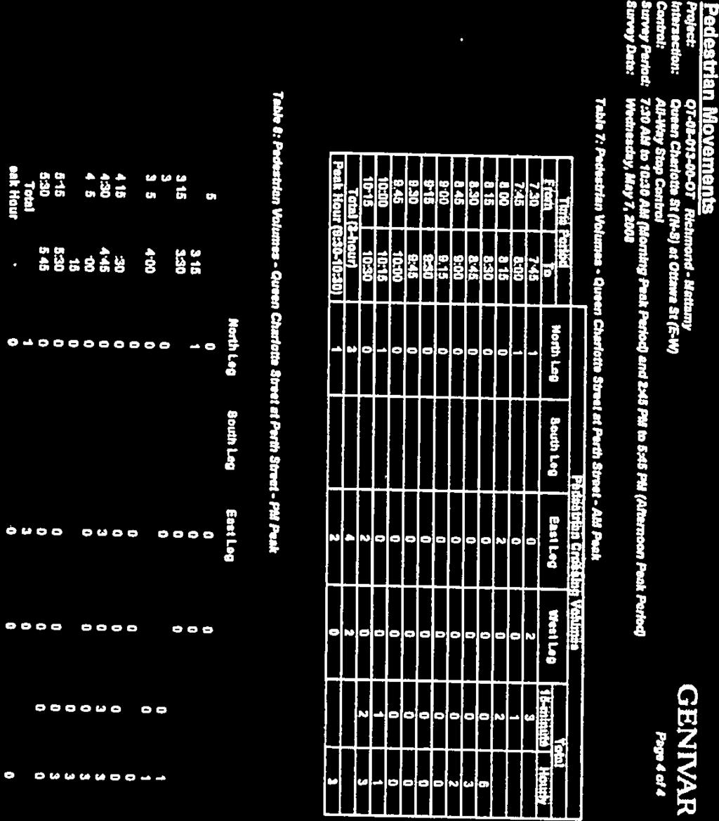
35 Richmond Village Traffic Count Ottawa Street and Queen Charlotte Street 27 Nov 12 NBL NBT NBR SBL SBT SBR EBL EBT EBR WBL WBT WBR 7:30 7: :45 8: :00 8: :15 8:30 1 Total NBL NBT NBR SBL SBT SBR EBL EBT EBR WBL WBT WBR 4:30 4: :45 5:00 1 5:00 5: :15 5: Total

36


37
38
39

40
41

42


43
44
45
46


47
48
49 Appendix B: Trip Generation
50 Mattamy North Mattamy South Fortune Street Mattamy North Mattamy South Fortune Street Mattamy North Mattamy South Land Use Units / Morning Peak Hour Units / Afternoon Peak Hour 1000's SF Rate Inbound Outbound 1000's SF Rate Inbound Outbound Single Family Detached % 75% % 37% Residential Condominium / Townhouse % 83% % 33% Single Family Detached % 75% % 37% Single Family Detached % 75% % 37% Synergy / Morning Peak Hour Synergy / Afternoon Peak Hour Pass By Inbound Outbound Total Pass By Inbound Outbound Total Single Family Detached Residential Condominium / Townhouse Total Single Family Detached Residential Condominium / Townhouse Total Single Family Detached Total Factor Inbound Outbound Total Factor Inbound Outbound Total Trip Gen Mode Share Auto Occupancy Mode Split Split Auto 85% % Passenger 10% % Transit 3% % Active Mode 2% % Trip Gen Mode Share Auto Occupancy Mode Split Split Auto 85% % Passenger 10% % Transit 3% % Active Mode 2% %
51 Fortune Street Total Trip Gen Mode Share Auto Occupancy Mode Split Split Auto 85% % Passenger 10% % Transit 3% % Active Mode 2% % Trip Gen Mode Share Auto Occupancy Mode Split Split Auto 85% % Passenger 10% % Transit 3% % Active Mode 2% %
52 Appendix C: Trip Distribution and Assignment
53 AM Rurual Southwest Percent Direction Ottawa Centre 670 6% N Ottawa Inner Area 760 6% N Ottawa East 160 1% N Beacon Hill 230 2% N Alta Vista 680 6% N Hunt Club 360 3% E Merivale 1,390 12% N Ottawa West 260 2% N Bayshore / Cedarview 770 7% N Orléans 80 1% N Rural East 0% E Rural Southeast 690 6% E South Gloucester / Leitrim 90 1% E South Nepean 310 3% N Rural Southwest 3,480 29% Kanata / Stittsville 1,430 12% N Rural West 80 1% W Île de Hull 110 1% N Hull Périphérie 110 1% N Plateau 0% N Aylmer 0% N Rural Northwest 10 0% N Pointe Gatineau 40 0% N Gatineau Est 70 1% N Rural Northeast 20 0% N Buckingham / Masson- Angers 0% E External 0% Total 11, % AM N 60% 63% E 10% 35% S 0% 0% W 1% 2%
November 11, 2009 BY . Planning and Growth Management Department 110 Laurier Avenue West, 4 th Floor Ottawa, Ontario K1P 1J1. Dear Mr.
 November 11, 2009 Planning and Growth Management Department 110 Laurier Avenue West, 4 th Floor Ottawa, Ontario K1P 1J1 BY E-MAIL Attention: Mr. Don Herweyer Dear Mr. Herweyer: Reference: Abbott-Fernbank
MARSHALL Subdivision. Township of Springwater, County of Simcoe. Traffic Brief for: Ontario Inc. Type of Document: Final Report
 MARSHALL Subdivision Township of Springwater, County of Simcoe Traffic Brief for: 489469 Ontario Inc. Type of Document: Final Report Project Number: JDE 1521 Date Submitted: October 19 th, 2016 10 / 19
MEMORANDUM. Bob Zagozda, Chief Financial Officer Westside Community Schools. Mark Meisinger, PE, PTOE Felsburg Holt & Ullevig. DATE: June 11, 2018
 MEMORANDUM TO: Bob Zagozda, Chief Financial Officer Westside Community Schools FROM: Mark Meisinger, PE, PTOE Felsburg Holt & Ullevig DATE: June 11, 218 6-11-18 SUBJECT: Sunset Hills Elementary School
Treasure Island Supplemental Information Report Addendum
 1 1 1 1 0 1 0 1 0 1 Treasure Island Supplemental Information Report Addendum Introduction Purpose The purpose of this Supplemental Information Report (SIR) Addendum is to determine if the current land
Planning. Proposed Development at the Southeast Corner of Lakeshore Road West and Brookfield Road Intersection FINAL.
 Project No. 121-22908 N o v e m b e r 2 0 1 2 Traffic Impact Study Transportation Planning th GENIVAR Inc., 600 Cochrane Drive, 5 Floor, Markham, Ontario L3R 5K3 Telephone: 905.475.7270 Fax: 905.475.5994
LUDWIG RD. SUBDIVISION PROJECT TRAFFIC IMPACT ANALYSIS
 LUDWIG RD. SUBDIVISION PROJECT TRAFFIC IMPACT ANALYSIS Prepared for Skip Coddington GSC Development, Inc PO Box 1623 Woodinville WA 9872 Prepared by 1141 NE 124 th St., #59 Kirkland, WA 9834 425.522.4118
Lake Erie Commerce Center Traffic Analysis
 LOCATION: East of NYS Route 5 at Bayview Road Town of Hamburg Erie County, New York PREPARED BY: Wendel Companies 140 John James Audubon Parkway Suite 200 Amherst, New York 14228 January 2012 i ii Table
TABLE OF CONTENTS. Coral Springs Charter High School and Middle School Job No Page 2
 Job No. 15-019 Page 2 TABLE OF CONTENTS 1.0 INTRODUCTION... 4 2.0 EXISTING CONDITIONS... 5 3.0 TRAFFIC GENERATION... 7 4.0 TRIP DISTRIBUTION... 8 5.0 FUTURE CONDITIONS... 8 6.0 SITE ACCESS...13 7.0 CONCLUSION...13
ITS. Intermountain Transportation Solutions Traffic Studies Transportation Analysis Signal Design Site Planning. January 9, 2013
 ITS Intermountain Transportation Solutions Traffic Studies Transportation Analysis Signal Design Site Planning Raymond Wright, P.E. City of Spokane Transportation Department 11707 East Sprague Avenue,
Aldridge Transportation Consultants, LLC Advanced Transportation Planning and Traffic Engineering
 Aldridge Transportation Consultants, LLC Advanced Transportation Planning and Traffic Engineering John M.W. Aldridge, PE, PTOE, AICP 182 Chimney Rock Road Colorado Registered Professional Engineer Highlands
A. CONCLUSIONS OF THE FGEIS
 Chapter 11: Traffic and Parking A. CONCLUSIONS OF THE FGEIS The FGEIS found that the Approved Plan will generate a substantial volume of vehicular and pedestrian activity, including an estimated 1,300
MEMORANDUM. Lynn Hayes LSA Associates, Inc.
 MEMORANDUM To: Lynn Hayes LSA Associates, Inc. Date: May 5, 217 From: Zawwar Saiyed, P.E., Senior Transportation Engineer Justin Tucker, Transportation Engineer I Linscott, Law & Greenspan, Engineers LLG
7272 WISCONSIN AVENUE LOCAL AREA TRANSPORTATION REVIEW
 7272 LOCAL AREA TRANSPORTATION REVIEW AND TRANSPORTATION POLICY AREA REVIEW MONTGOMERY COUNTY, MARYLAND Submitted on behalf of Carr Properties Prepared by: Wells + Associates, Inc. Submission: July 1,
Interstate 90 and Mercer Island Mobility Study APRIL Commissioned by. Prepared by
 Interstate 90 and Mercer Island Mobility Study APRIL 2017 Commissioned by Prepared by Interstate 90 and Mercer Island Mobility Study Commissioned by: Sound Transit Prepared by: April 2017 Contents Section
12, 14 and 16 York Street - Amendments to Section 16 Agreement and Road Closure Authorization
 REPORT FOR ACTION 12, 14 and 16 York Street - Amendments to Section 16 Agreement and Road Closure Authorization Date: April 27, 2018 To: Toronto and East York Community Council From: Senior Strategic Director,
Traffic Analysis Final Report
 SR-71 Widening Project Project Approval/Environmental Documentation Traffic Analysis Final Report Prepared for Caltrans District 7 August 2012 6 Hutton Centre Drive, Suite 700 Santa Ana, California 92707
Madison Metro Transit System
 Madison Metro Transit System 1101 East Washington Avenue Madison, Wisconsin, 53703 Administrative Office: 608 266 4904 Fax: 608 267 8778 TO: FROM: SUBJECT: Plan Commission Timothy Sobota, Transit Planner,
Caliber Charter School VALLEJO, CA
 Traffic Impact Study Final Report Caliber Charter School VALLEJO, CA 21 June 2016 Prepared for: Prepared by: Traffic Engineering & Transportation Planning This report has been prepared and certified by
EXISTING CONDITIONS A. INTRODUCTION. Route 107 Corridor Study Report
 II. EXISTING CONDITIONS A. INTRODUCTION The Route 107 study area extends from the south at Chestnut Street in Lynn approximately 3.7 miles to the north to Boston Street in Salem. The study area has three
Transport Impact Assessment
 Transport Impact Assessment Springbok Hotel Erf 5206, Springbok Northern Cape March 2018 5th Floor Imperial Terraces Carl Cronje Drive Tyger Waterfront Bellville, 7530 (021) 914 6211 (T) e mail: mail@itsglobal.co.za
Pedestrian Safety Review Spadina Avenue
 STAFF REPORT ACTION REQUIRED Pedestrian Safety Review Spadina Avenue Date: October 13, 2015 To: Toronto and East York Community Council From: Director, Transportation Services, Toronto and East York District
Freymond Aggregates Quarry 2287 Bay Lake Road Twp. of Faraday, Hastings County
 Freymond Aggregates Quarry 2287 Bay Lake Road Twp. of Faraday, Hastings County Traffic Impact Study Prepared by: Tranplan Associates PO Box 455 Lakefield, ON K0L 2H0 www.tranplan.com Prepared for: Freymond
DOGWOOD AT VILLA AVENUE PROJECT
 TRANSPORTATION IMPACT ANALYSIS DOGWOOD AT VILLA AVENUE PROJECT El Centro, California September 4, 2018 LLG Ref. 3-17-2782 TABLE OF CONTENTS SECTION PAGE Appendices... ii List of Figures... i List of Tables...
Trans Canada Highway Corridor Management Plan. Final Draft Report. Drinkwater Road to Cowichan Bay Road. Prepared for:
 Trans Canada Highway Corridor Management Plan inal Draft Report Prepared for: City of Duncan Cowichan Tribes Council District of North Cowichan Cowichan Valley Regional District South Coast Region of the
According to FAA Advisory Circular 150/5060-5, Airport Capacity and Delay, the elements that affect airfield capacity include:
 4.1 INTRODUCTION The previous chapters have described the existing facilities and provided planning guidelines as well as a forecast of demand for aviation activity at North Perry Airport. The demand/capacity
4. Safety Concerns Potential Short and Medium-Term Improvements
 NH Route 104 Access Management Study Page 19 4. Safety Concerns Potential Short and Medium-Term Improvements Potential safety improvement strategies are listed by priority based on field observations by
PURPOSE AND NEED (CONCURRENCE POINT 1) NEW CANADA ROAD PROJECT FROM STATE ROUTE 1 (U.S. HIGHWAY 70) TO U.S. INTERSTATE 40
 NEW CANADA ROAD PROJECT FROM STATE ROUTE 1 (U.S. HIGHWAY 70) TO U.S. INTERSTATE 40") PURPOSE AND NEED (CONCURRENCE POINT 1) NEW CANADA ROAD PROJECT FROM STATE ROUTE 1 (U.S. HIGHWAY 70) TO U.S. INTERSTATE 40 Project Description The primary purpose of this project is to improve the major
PURPOSE AND NEED (CONCURRENCE POINT 1) NEW CANADA ROAD PROJECT FROM STATE ROUTE 1 (U.S. HIGHWAY 70) TO U.S. INTERSTATE 40 Project Description The primary purpose of this project is to improve the major
HDR itrans Consulting Inc. 100 York Blvd., Suite 300 Richmond Hill, ON L4B 1J8 Tel: (905) Fax: (905)
 Fax: (905)") !" # $ !" # $ Consulting Inc. 100 York Blvd., Suite 300 Richmond Hill, ON L4B 1J8 Tel: (905) 882-4100 Fax: (905) 882-1557 www.itransconsulting.com November 2009 %&'('$&$ 1. West Brampton Road Network...
!" # $ !" # $ Consulting Inc. 100 York Blvd., Suite 300 Richmond Hill, ON L4B 1J8 Tel: (905) 882-4100 Fax: (905) 882-1557 www.itransconsulting.com November 2009 %&'('$&$ 1. West Brampton Road Network...
Site Location and Setting
 Memorandum Date: To: From: Subject: Kristy Le, Gary Black Steve Orem Santa Teresa County Park Historic Area Traffic and Parking Study Hexagon Transportation Consultants, Inc. has completed a traffic and
Proposed Bicycle Lanes on Yonge Street from Queens Quay to Front Street
 STAFF REPORT ACTION REQUIRED Proposed Bicycle Lanes on Yonge Street from Queens Quay to Front Street Date: March 12, 2007 To: From: Toronto and East York Community Council Director, Transportation Infrastructure
Spadina Avenue Built Form Study Preliminary Report
 STAFF REPORT ACTION REQUIRED Spadina Avenue Built Form Study Preliminary Report Date: July 9, 2014 To: From: Wards: Reference Number: Toronto and East York Community Council Director, Community Planning,
Runway Length Analysis Prescott Municipal Airport
 APPENDIX 2 Runway Length Analysis Prescott Municipal Airport May 11, 2009 Version 2 (draft) Table of Contents Introduction... 1-1 Section 1 Purpose & Need... 1-2 Section 2 Design Standards...1-3 Section
URBAN DESIGN REPORT. Proposed Residential Development, Old Church Road, Caledon East
 Proposed Residential Development, Old Church Road, Caledon East TABLE CONTENTS: 1.0 DEVELOPMENT 1.1 Introduction-Analysis of Guiding Principles and Documents 1.2 Community Design and Architectural Design
London Borough of Barnet Traffic & Development Design Team
 London Borough of Barnet Traffic & Development Design Team AERODROME ROAD PEDESTRIAN FACILITY AND BUS STOP INTRODUCTION FEASIBILITY REPORT Job Number: 60668 Doc Ref: S106/12-13/60668 Author: Manoj Kalair
1.2 Corridor History and Current Characteristics
 SECTION 1 Description and Background of Study Area 1.1 Introduction This preliminary engineering report was prepared for the Alaska Department of Transportation and Public Facilities (ADOT&PF). It is part
Glasgow Street Traffic Review
 Glasgow Street Traffic Review Recommendation That the Standing Policy Committee on Transportation recommend to City Council: 1. That the Administration proceed with removing the pinch points installed
5.1 Traffic and Transportation
 5.1 When it opens in 2009, the Bellevue Nickel Improvement Project will increase the number of vehicles able to travel through the study area, improve travel speeds, and improve safety by reducing the
Macleod Trail Corridor Study. Welcome. Macleod Trail Corridor Study Open House. Presentation of Proposed Design Concepts
 Macleod Trail Corridor Study Welcome Macleod Trail Corridor Study Open House Presentation of Proposed Design Concepts Study Purpose Develop a corridor plan for Macleod Trail that aligns with The City s:
Committee. Presentation Outline
 CW-33-15 11/9/2015 Community and Corporate Services Committee November 10, 2015 1 Presentation Outline Background Vision and Objectives Study Process and Timeline Public and Stakeholder Engagement Organization
APPENDIX J TRAFFIC AND PARKING DEMAND STUDIES
 APPENDIX J TRAFFIC AND PARKING DEMAND STUDIES Table of Contents Executive Summary... iv 1.0 Introduction... 1 2.0 Traffic Analysis Methodology and Significance Criteria... 4 2.1 Study Area Criteria...
Engagement Summary Report. Trans-Canada Highway 1 RW Bruhn Bridge Replacement Project. Community Engagement November 15, 2016 to January 15, 2017
 Trans-Canada Highway 1 RW Bruhn Bridge Replacement Project Community Engagement November 15, 2016 to January 15, 2017 Engagement Summary Report February 2017 Prepared by Kirk & Co. Consulting Ltd. Trans-Canada
Transportation Impact Assessment Paradise Shores RV Resort Development Stettler County, Alberta Progress Update February 2018 PO#
 February 20, 2018 RV Sites Canada 300, 1933A 10 Avenue SW Calgary, AB T23C 0K3 Attn: Re: Rick Halpern Transportation Impact Assessment Paradise Shores RV Resort Development Stettler County, Alberta Progress
Washington Dulles International Airport (IAD) Aircraft Noise Contour Map Update
 Aircraft Noise Contour Map Update") Washington Dulles International Airport (IAD) Aircraft Noise Contour Map Update Ultimate ASV, Runway Use and Flight Tracks 4th Working Group Briefing 8/13/18 Meeting Purpose Discuss Public Workshop input
Washington Dulles International Airport (IAD) Aircraft Noise Contour Map Update Ultimate ASV, Runway Use and Flight Tracks 4th Working Group Briefing 8/13/18 Meeting Purpose Discuss Public Workshop input
APPENDIX H MILESTONE 2 TRAFFIC OPERATIONS ANALYSIS OF THE AT-GRADE CROSSINGS
 Draft Environmental Impact Statement/Environment Impact Report Appendix H Milestone 2 Traffic Operations Analysis of the At-Grade Crossings APPENDIX H MILESTONE 2 TRAFFIC OPERATIONS ANALYSIS OF THE AT-GRADE
Non-technical summary
 Introduction NTS1 NTS2 NTS3 Troika Developments Ltd (Troika) has submitted a planning application to Bournemouth Borough Council (BBC) for an extension of time to implement planning permission 7/2004/16450/G,
Sky Temporary Car Park Transport Statement
 001 Issue 26 August 2016 This report takes into account the particular instructions and requirements of our client. It is not intended for and should not be relied upon by any third party and no responsibility
2008 DEKALB COUNTY TRANSPORTATION PLAN (UPDATE)
") 2008 DEKALB COUNTY TRANSPORTATION PLAN (UPDATE) TABLE OF CONTENTS Introduction 1 Transportation Planning Activities 2 Identification of Problem Areas and Recommended Solutions 7 DeKalb County Projects
2008 DEKALB COUNTY TRANSPORTATION PLAN (UPDATE) TABLE OF CONTENTS Introduction 1 Transportation Planning Activities 2 Identification of Problem Areas and Recommended Solutions 7 DeKalb County Projects
Chapter 4.0 Alternatives Analysis
 Chapter 4.0 Alternatives Analysis Chapter 1 accumulated the baseline of existing airport data, Chapter 2 presented the outlook for the future in terms of operational activity, Chapter 3 defined the facilities
TRANSPORTATION ELEMENT
 Transportation TRANSPORTATION ELEMENT Data, Inventory, and Analysis Prepared by Contents 1.0 INTRODUCTION... 1 2.0 EXISTING CONDITIONS... 1 2.1 Roadways... 1 2.1.1 Jurisdiction... 1 2.1.2 Functional Classification...
Shadow Impact Assessment & 2323 Lake Shore Boulevard West. Etobicoke, Ontario
 Shadow Impact Assessment 2313 & 2323 Lake Shore Boulevard West Etobicoke, Ontario REPORT: GWE12-099-SHADOWS-2014 Prepared For: Peter Swinton, B.Arch., MCIP, RPP PMG Planning Consultants 227 Bridgeland
Director, Community Planning, Toronto and East York District
 STAFF REPORT October 25, 2005 To: From: : Subject: Toronto and East York Community Council Director, Community Planning, Toronto and East York District Status Report OPA & Rezoning Application 05 117524
2009 Muskoka Airport Economic Impact Study
 2009 Muskoka Airport Economic Impact Study November 4, 2009 Prepared by The District of Muskoka Planning and Economic Development Department BACKGROUND The Muskoka Airport is situated at the north end
STAFF REPORT. Airport Land Use Plan Consistency Review: Santa Barbara Airport Master Plan. MEETING DATE: November 19, 2015 AGENDA ITEM: 7D
 STAFF REPORT SUBJECT: Airport Land Use Plan Consistency Review: Santa Barbara Airport Master Plan MEETING DATE: AGENDA ITEM: 7D STAFF CONTACT: Peter Imhof, Andrew Orfila RECOMMENDATION: Adopt findings
Toronto 2015 Pan Am/Parapan Am Games Temporary Traffic By-law Amendments for High Occupancy Vehicle Lanes (Supplementary Report)
") STAFF REPORT ACTION REQUIRED Toronto 2015 Pan Am/Parapan Am Games Temporary Traffic By-law Amendments for High Occupancy Vehicle Lanes (Supplementary Report) Date: March 25, 2015 To: From: Wards: Reference
STAFF REPORT ACTION REQUIRED Toronto 2015 Pan Am/Parapan Am Games Temporary Traffic By-law Amendments for High Occupancy Vehicle Lanes (Supplementary Report) Date: March 25, 2015 To: From: Wards: Reference
CHAPTER 4: ALTERNATIVES
 MSP Long Term Comprehensive Plan Update Metropolitan Airports Commission 4.1 INTRODUCTION CHAPTER 4: ALTERNATIVES Several alternatives were developed and evaluated based on their capability to meet the
2433 Dufferin Street Zoning By-law Amendment Application - Preliminary Report
 STAFF REPORT ACTION REQUIRED 2433 Dufferin Street Zoning By-law Amendment Application - Preliminary Report Date: July 22, 2014 To: From: Wards: Reference Number: North York Community Council Director,
Hospital Link Project Project Update Winter 2018
 Hospital Link Project Project Update Winter 2018 General The project provides a link from Riverside Drive and the Transitway to the Hospital Link Road. Construction of the Hospital Link facility is open
PORTS TORONTO Billy Bishop Toronto City Airport Summary of 2015 Traffic and Passenger Surveys
 PORTS TORONTO Billy Bishop Toronto City Airport Summary of 2015 Traffic and Passenger Surveys 1 Summary of 2015 BBTCA Traffic and Passenger Surveys Surveys of traffic volumes and pedestrian activity were
Project No Brent Cross, Cricklewood London, UK Phase 1A North RMA
 Project No. 431679 Brent Cross, Cricklewood London, UK Phase 1A North RMA River Overshadowing Impact Study For Waterman Energy, Environment & Design 18 th November 2014 431679 Report 2 Rel.3 1 of 23 431679rep2v3.docx
9 CONSTRUCTION OF BATHURST STREET FROM GREEN LANE WEST TO SOUTH OF HIGHWAY 11, TOWN OF EAST GWILLIMBURY AND TOWNSHIP OF KING
 Clause No. 9 in Report No. 9 of Committee of the Whole was adopted, without amendment, by the Council of The Regional Municipality of York at its meeting held on May 15, 2014. 9 CONSTRUCTION OF BATHURST
Bloor Street West Rezoning Application for a Temporary Use By-law Final Report
 STAFF REPORT ACTION REQUIRED 3741 3751 Bloor Street West Rezoning Application for a Temporary Use By-law Final Report Date: June 12, 2007 To: From: Wards: Reference Number: Etobicoke York Community Council
Draft Concept Alternatives Analysis for the Inaugural Airport Program September 2005
 Draft Concept Alternatives Analysis for the Inaugural Airport Program September 2005 Section 1 - Introduction This report describes the development and analysis of concept alternatives that would accommodate
11th and Vermont Streets Special General Land Use Plan (GLUP) Study
 Study") 11th and Vermont Streets Special General Land Use Plan (GLUP) Study Planning Commission Agenda Item #3 May 11, 2017 Department of Community Planning, Housing and Development Presentation Contents 1. Background
11th and Vermont Streets Special General Land Use Plan (GLUP) Study Planning Commission Agenda Item #3 May 11, 2017 Department of Community Planning, Housing and Development Presentation Contents 1. Background
10.0 Recommendations Methodology Assumptions
 10.0 Recommendations To accommodate the projected growth of the I-526 corridor, this report has summarized potential improvement strategies that were separated into four categories, TDM, Modal, Traffic
383 Herring Cove Road Traffic Impact Statement. April Prepared for. Servant Dunbrack McKenzie & MacDonald Ltd.
 383 Herring Cove Road Traffic Impact Statement April 2015 Prepared for Servant Dunbrack McKenzie & MacDonald Ltd JRL consulting JRL consulting TABLE OF CONTENTS 1 INTRODUCTION... 2 1.1 BACKGROUND... 2
Saighton Camp, Chester. Technical Note: Impact of Boughton Heath S278 Works upon the operation of the Local Highway Network
 Technical Note: Impact of Boughton Heath S278 Works July 2013 SAIGHTON CAMP CHESTER COMMERCIAL ESTATES GROUP TECHNICAL NOTE: IMPACT OF BOUGHTON HEATH S278 WORKS UPON THE OPERATION OF THE LOCAL HIGHWAY
Appendix 8: Coding of Interchanges for PTSS
 FILE NOTE DATE 23 October 2012 AUTHOR SUBJECT Geoffrey Cornelis Appendix 8: Coding of Interchanges for PTSS 1. Introduction This notes details a proposed approach to improve the representation in WTSM
STAR Bond Development
 STR ond Development Traffic Impact Study Goddard, Kansas Prepared for: Kansas Department of Transportation City of Goddard, Kansas Prepared by TranSystems November 218 November 3, 218 Kansas Department
Draft Concept Alternatives Analysis for the Inaugural Airport Program September 2005
 Section 10 Preferred Inaugural Airport Concept 10.0 Introduction The Preferred Inaugural Airport Concept for SSA was developed by adding the preferred support/ancillary facilities selected in Section 9
Memorandum. Fund Allocation Fund Programming Policy/Legislation Plan/Study Capital Project Oversight/Delivery Budget/Finance Contract/Agreement Other:
 Memorandum Date: March 23, 2018 To: Transportation Authority Board From: Eric Cordoba Deputy Director Capital Projects Subject: 4/10/18 Board Meeting: San Francisco Freeway Corridor Management Study Update
3. COLTA / HUGA CONNECTIONS - PRELIMINARY
 9 3. COLTA / HUGA CONNECTIONS - PRELIMINARY 3.1 COLTA The Chain of Lakes Trail Association (COLTA) trail, formerly identified as the Chester Spur Line, was completed and opened for use in June 2011. The
Draft Concept Alternatives Analysis for the Inaugural Airport Program September 2005
 Draft Concept Alternatives Analysis for the Inaugural Airport Program September 2005 Section 3 - Refinement of the Ultimate Airfield Concept Using the Base Concept identified in Section 2, IDOT re-examined
8 CROSS-BOUNDARY AGREEMENT WITH BRAMPTON TRANSIT
 8 CROSS-BOUNDARY AGREEMENT WITH BRAMPTON TRANSIT The Transportation Services Committee recommends the adoption of the recommendations contained in the following report dated May 27, 2010, from the Commissioner
Score. Category. Access Aesthetics Community Resources
 NO BUILD ALTERNATIVE The No Build Alternative is the do nothing option that is used for comparison to the build alternatives. The screening assumes no new facilities are constructed as part of the I-93
Memorandum. Roger Millar, Secretary of Transportation. Date: April 5, Interstate 90 Operations and Mercer Island Mobility
 Memorandum To: From: The Honorable Dow Constantine, King County Executive; The Honorable Ed Murray, City of Seattle Mayor; The Honorable Bruce Bassett, City of Mercer Island Mayor; The Honorable John Stokes,
Westover Metropolitan Airport Master Plan Update
 Westover Metropolitan Airport Master Plan Update June 2008 INTRODUCTION Westover Metropolitan Airport (CEF) comprises the civilian portion of a joint-use facility located in Chicopee, Massachusetts. The
MONTEREY REGIONAL AIRPORT MASTER PLAN TOPICAL QUESTIONS FROM THE PLANNING ADVISORY COMMITTEE AND TOPICAL RESPONSES
 MONTEREY REGIONAL AIRPORT MASTER PLAN TOPICAL QUESTIONS FROM THE PLANNING ADVISORY COMMITTEE AND TOPICAL RESPONSES Recurring topics emerged in some of the comments and questions raised by members of the
DISTRICT EXPRESS LANES ANNUAL REPORT FISCAL YEAR 2017 JULY 1, 2016 JUNE 30, FloridaExpressLanes.com
 DISTRICT EXPRESS LANES ANNUAL REPORT FISCAL YEAR 2017 JULY 1, 2016 JUNE 30, 2017 FloridaExpressLanes.com This page intentionally left blank. TABLE OF CONTENTS List of Figures... ii List of Tables.... ii
Section 106 Update Memo #1 Attachment D. Traffic Diversion & APE Expansion Methodology & Maps
 Section 106 Update Memo #1 Attachment D Traffic Diversion & APE Expansion Methodology & Maps I-65/I-70 North Split Interchange Reconstruction Project (Des. Nos. 1592385 & 1600808) Traffic Diversion and
user s guide to Transportation Improvements in Astoria Planning Efforts outside Astoria for more information, contact:
 The Miles Crossing/ Jeffers Garden transportation plan (underway), will identify needed improvements to the Warrenton Astoria Highway and local street improvements to serve expected growth in the Miles
NORTH FRASER PERIMETER ROAD WEST CORRIDOR DEFINITION STUDY
 NORTH FRASER PERIMETER ROAD WEST CORRIDOR DEFINITION STUDY MAY 2011 SW1132SWD NORTH FRASER PERIMETER ROAD WEST CORRIDOR DEFINITION STUDY TABLE OF CONTENTS 1.0 INTRODUCTION... 1 2.0 CURRENT TRAVEL PATTERNS
PELICAN LANDING RAPTOR BAY REZONING TRANSPORTATION METHODOLOGY OUTLINE
 PELICAN LANDING RAPTOR BAY REZONING TRANSPORTATION METHODOLOGY OUTLINE Project No. 15534 Prepared by: DAVID PLUMMER & ASSOCIATES, INC. 2149 McGregor Boulevard June 24, 2016 Fort Myers, Florida 33901 Pelican
THIRTEENTH AIR NAVIGATION CONFERENCE
 International Civil Aviation Organization AN-Conf/13-WP/22 14/6/18 WORKING PAPER THIRTEENTH AIR NAVIGATION CONFERENCE Agenda Item 1: Air navigation global strategy 1.4: Air navigation business cases Montréal,
TRAFFIC IMPACT STUDY REPORT FOR PROPOSED OFFICE PROJECT AT 959 SEWARD STREET IN HOLLYWOOD SNYDER PARTNERS
 DRAFT TRAFFIC IMPACT STUDY REPORT FOR PROPOSED OFFICE PROJECT AT 959 SEWARD STREET IN HOLLYWOOD Prepared for: SNYDER PARTNERS Prepared by: Crain & Associates 2007 Sawtelle Boulevard, Suite 4 Los Angeles,
 Existing Conditions AIRPORT PROFILE Passenger Terminal Complex 57 air carrier gates 11,500 structured parking stalls Airfield Operations Area 9,000 North Runway 9L-27R 6,905 Crosswind Runway 13-31 5,276
THRESHOLD GUIDELINES FOR AVALANCHE SAFETY MEASURES
 BRITISH COLUMBIA MINISTRY OF TRANSPORTATION & INFRASTRUCTURE AVALANCHE & WEATHER PROGRAMS THRESHOLD GUIDELINES FOR AVALANCHE SAFETY MEASURES British Columbia Ministry of Transportation & Infrastructure
Longmont to Boulder Regional Trail Jay Road Connection DRAFT FINAL REPORT
 Longmont to Boulder Regional Trail Jay Road Connection DRAFT FINAL REPORT December 2018 Project Summary Boulder County, Colorado, in partnership with the City of Boulder, is evaluating options for multi-use
FNORTHWEST ARKANSAS WESTERN BELTWAY FEASIBILITY STUDY
 FNORTHWEST ARKANSAS WESTERN BELTWAY FEASIBILITY STUDY EXECUTIVE SUMMARY The 2030 Northwest Arkansas Regional Transportation Plan developed by the Northwest Arkansas Regional Planning Commission (NWARPC)
Assessment of Travel Trends
 I - 2 0 E A S T T R A N S I T I N I T I A T I V E Assessment of Travel Trends Prepared for: Metropolitan Atlanta Rapid Transit Authority Prepared by: AECOM/JJG Joint Venture Atlanta, GA October 2011 General
Other Principle Arterials Minor Arterial Major Collector Minor Collector Local
 CHAPTER 10 TRANSPORTATION Introduction The system of public roads in East Pikeland Township is decidedly rural in character. Since the 1984, the road network has remained much the same, with the addition
INNOVATIVE TECHNIQUES USED IN TRAFFIC IMPACT ASSESSMENTS OF DEVELOPMENTS IN CONGESTED NETWORKS
 INNOVATIVE TECHNIQUES USED IN TRAFFIC IMPACT ASSESSMENTS OF DEVELOPMENTS IN CONGESTED NETWORKS Andre Frieslaar Pr.Eng and John Jones Pr.Eng Abstract Hawkins Hawkins and Osborn (South) Pty Ltd 14 Bree Street,
5 Rail demand in Western Sydney
 5 Rail demand in Western Sydney About this chapter To better understand where new or enhanced rail services are needed, this chapter presents an overview of the existing and future demand on the rail network
LYNDHURST NEW URBAN DEVELOPMENT AREA STRUCTURE PLAN. Lyndhurst New Urban Development Area Structure Plan OUTCOMES AND PERFORMANCE STANDARDS
 APPENDIX 15.1-3 LYNDHURST NEW URBAN DEVELOPMENT AREA STRUCTURE PLAN Purpose of the Structure Plan Lyndhurst New Urban Development Area Structure Plan OUTCOMES AND PERFORMANCE STANDARDS LSP-P1 The District
TORONTO TRANSIT COMMISSION REPORT NO.
 Revised: March/13 TORONTO TRANSIT COMMISSION REPORT NO. MEETING DATE: SUBJECT: Resubmitted: November 18, 2013 October 23, 2013 TTC Fare Policy - Requests for Fare Discounts ACTION ITEM RECOMMENDATION It
Watts St westbound thru
 Executive Summary At the request of the Hudson Square Business Improvement District, Sam Schwartz Engineering, DPC (Sam Schwartz) has completed a technical analysis of various congestion pricing and/or
Sunshine Coast Airport Master Plan September 2007
 Sunshine Coast Airport Master Plan September 2007 Contents CONTENTS... I ACKNOWLEDGEMENT... II DISCLAIMER... III 1 EXECUTIVE SUMMARY...IV 1 INTRODUCTION... 1 2 AVIATION DEMAND FORECAST... 5 3 AIRCRAFT
377 Spadina Rd & 17 Montclair Ave Zoning Amendment Application Final Report
 STAFF REPORT ACTION REQUIRED 377 Spadina Rd & 17 Montclair Ave Zoning Amendment Application Final Report Date: September 14, 2016 To: From: Wards: Reference Number: Toronto and East York Community Council
Kingston Transportation Master Plan Draft Report Transit Forecasting 1
 TRANSIT FORECASTING Transit Forecasting 1 INTRODUCTION A spreadsheet model was developed to identify existing transit deficiencies and additional transit service requirements. The model comprised transit
Launceston City Council. Kings Meadows Traffic Management Report for Public Consultation
 Launceston City Council Kings Meadows Traffic Management Report for Public Consultation November 2013 This report: has been prepared by GHD for Launceston City Council and may only be used and relied on
Freymond Aggregates Quarry Bay Lake Rd., Twp. of Faraday
 Freymond Aggregates Quarry Bay Lake Rd., Twp. of Faraday Traffic Brief South Site Entrance Prepared by: Tranplan Associates PO Box 455 Lakefield, ON K0L 2H0 www.tranplan.com Prepared for: EcoVue Consulting