DEPARTMENT OF CIVIL AVIATION
|
|
|
- Rosalind Blankenship
- 5 years ago
- Views:
Transcription
1 Phone : FAX : AFTN : VTBAYOYX aisthai@aviation.go.th DEPARTMENT OF CIVIL AVIATION AERONAUTICAL INFORMATION SERVICE TUNG-MAHAMEK, BANGKOK AIP - Amendment 4 29 JUL Insert the attached replacement pages. The checklist (GEN TO GEN 0.4-9) gives lists of pages that are current in the whole AIP after the incorporation of this amendment. New or replacement pages are indicated with an asterisk (*). Amended text has been identified by a vertical line, or an arrow in the margin of the replacement pages. 2. Record entry of amendment on page GEN This amendment incorporates information contained in the following which are hereby superseded: C2884 C2653 C4147 C7416 / 2964 C0652 C1124 / A0602 C1387 / A0735 C1556 C1937 / A0940 C1986 / A0961 C3600 NOTAM 1999 NOTAM 2001 NOTAM 2004 NOTAM 2009 NOTAM 2010 C1123 / A0601 C1229 / A0667 C1388 / A0736 C1909 / A0936 C1985 / A0960 C2474 AIP Supplement : Series A 2004 : A : A17 A : A : A2 A4 A5 A6 AIP Supplement : Series B 2009 : B1 B3 B : B2 B4
2 Phone : FAX : AFTN : VTBAYOYX aisthai@aviation.go.th DEPARTMENT OF CIVIL AVIATION AERONAUTICAL INFORMATION SERVICE TUNG-MAHAMEK, BANGKOK AIP - Amendment 4 29 JUL 10
3 AIP GEN JUL 10 GEN 0.4 CHECKLIST OF AIP PAGES (* DENOTES NEW OR REPLACEMENT PAGES) Page Date Page Date Page Date PART 1-GENERAL (GEN) Jul 09 * Jul 10 GEN Jul 09 * Jul Dec Jul 09 * Jul Dec Jul Dec Dec Dec Dec Dec Dec Dec Dec Dec /Chart 10 Dec 08 * Jul 10 * Jul Dec 08 * Jul 10 * Jul Dec 08 * Jul Dec Dec 08 * Jul Dec /Chart 10 Dec 08 * Jul Dec 08 GEN 4 * Jul Dec 08 * Jul 10 * Jul Dec 08 * Jul 10 * Jul 10 GEN 3 * Jul 10 * Jul 10 * Jul 10 * Jul Dec Dec 08 * Jul Dec Dec 08 * Jul Dec 08 * Jul 10 * Jul 10 GEN 1 * Jul 10 * Jul Dec Dec Mar Dec Dec Dec Nov 09 PART 2-EN-ROUTE(ENR) Dec Dec 08 ENR Dec Dec Nov Dec Dec Dec Dec Dec 08 ENR 1 * Jul Dec Dec 08 * Jul Dec Dec Dec Dec Dec Dec Dec Dec Dec Dec Dec Dec Dec Dec Dec Dec Dec 08 * Jul Dec Dec Mar Dec Dec 08 GEN Dec Dec Dec Dec Dec 08 * Jul Dec Dec Jul Dec 08 * Jul Jul Dec 08 * Jul Jul Dec Dec Jul Dec Dec Jul Dec Mar Jul Dec Dec Jul Dec Nov 09
4 GEN AIP 29 JUL 10 GEN 0.4 CHECKLIST OF AIP PAGES (* DENOTES NEW OR REPLACEMENT PAGES) Page Date Page Date Page Date 1.6-9/Chart 10 Dec 08 ENR 2 * Jul Dec Mar Jul Dec Dec 08 * Jul Dec Dec Dec Dec Dec Dec Dec Dec Mar Dec Mar Dec Dec Mar Dec Dec Dec Mar Dec Dec 08 * Jul Nov Mar Dec Nov Mar Dec Nov Mar Dec Nov Mar Mar Nov Mar Mar Nov Mar Mar Nov Mar Mar Nov Mar /Chart 10 Dec Nov Mar 10 * Jul Nov Mar Mar Nov Mar Mar Nov Mar Dec Nov Mar 10 ENR Nov Mar Mar Nov Mar Mar Nov Mar Mar Mar Mar Mar Dec Mar Mar Dec Mar Mar Mar Mar Mar Dec 08 * Jul Mar Dec 08 * Jul Mar Dec 08 * Jul Mar Dec 08 * Jul Mar Dec 08 * Jul Mar Dec 08 * Jul Dec Dec 08 * Jul Mar Dec 08 * Jul Mar Dec 08 * Jul Mar Dec 08 * Jul 10 * Jul Dec 08 * Jul 10 * Jul Dec 08 * Jul 10 ENR Dec 08 * Jul Dec Dec 08 ENR Dec Dec 08 * Jul 10 * Jul 10
5 AIP GEN JUL 10 GEN 0.4 CHECKLIST OF AIP PAGES (* DENOTES NEW OR REPLACEMENT PAGES) Page Date Page Date Page Date Mar 10 * Jul 10 *VTBD AD 2-46/Chart 29 Jul Dec Dec 08 *VTBD AD 2-47/Chart 29 Jul Dec Dec 08 *VTBD AD 2-48/Chart 29 Jul Dec Dec 08 *VTBD AD 2-49/Chart 29 Jul Mar Dec 08 *VTBD AD 2-50/Chart 29 Jul Dec Dec 08 *VTBD AD 2-51/Chart 29 Jul Dec Dec 08 *VTBD AD 2-52/Chart 29 Jul Dec Dec Dec /Chart 10 Dec Dec Dec Dec Dec 08 * Jul 10 AD 2 CHING MAI / INTL Dec 08 DON MUEANG / INTL VTCC AD Dec Dec 08 VTBD AD Jul 09 VTCC AD Dec Dec 08 VTBD AD Mar 10 *VTCC AD Jul Dec 08 VTBD AD Jul 09 VTCC AD Dec Dec 08 VTBD AD Dec 08 VTCC AD Dec Dec 08 VTBD AD Dec 08 VTCC AD Dec 08 ENR 6 VTBD AD Jul 09 VTCC AD Dec Dec 08 VTBD AD Jul 09 VTCC AD Dec 08 *VTBD AD Jul 10 *VTCC AD Jul 10 VTBD AD Jul 09 *VTCC AD Jul 10 PART 3 AERODROME (AD) VTBD AD Dec 08 *VTCC AD Jul 10 AD 0 VTBD AD Jul 09 VTCC AD Dec Dec 08 VTBD AD Jul 09 VTCC AD Dec 08 * Jul 10 VTBD AD Dec 08 VTCC AD Mar 10 * Jul 10 VTBD AD Mar 10 VTCC AD Mar 10 * Jul 10 VTBD AD Mar 10 VTCC AD Jul Dec 08 *VTBD AD Jul 10 VTCC AD Dec Dec 08 *VTBD AD Jul 10 *VTCC AD Jul Dec 08 *VTBD AD Jul 10 VTCC AD 2-21/Chart 10 Dec Jul 09 *VTBD AD Jul 10 VTCC AD 2-23/Chart 10 Dec Dec 08 *VTBD AD Jul 10 VTCC AD 2-25/Chart 10 Dec Dec 08 *VTBD AD Jul 10 VTCC AD 2-27/Chart 10 Dec Dec 08 *VTBD AD Jul 10 VTCC AD 2-29/Chart 10 Dec Dec 08 *VTBD AD Jul 10 VTCC AD 2-31/Chart 10 Dec Dec 08 *VTBD AD Jul 10 VTCC AD 2-32/Chart 10 Dec Dec 08 *VTBD AD Jul 10 VTCC AD 2-33/Chart 10 Dec Dec 08 *VTBD AD 2-29/Chart 29 Jul 10 VTCC AD 2-34/Chart 10 Dec Dec 08 *VTBD AD 2-31/Chart 29 Jul 10 VTCC AD 2-35/Chart 10 Dec Jul 09 *VTBD AD 2-33/Chart 29 Jul 10 VTCC AD 2-36/Chart 10 Dec Jul 09 *VTBD AD 2-35/Chart 29 Jul 10 VTCC AD 2-37/Chart 10 Dec 08 AD 1 *VTBD AD 2-37/Chart 29 Jul 10 VTCC AD 2-39/Chart 10 Dec 08 * Jul 10 *VTBD AD 2-39/Chart 29 Jul 10 VTCC AD 2-41/Chart 10 Dec Dec 08 *VTBD AD 2-41/Chart 29 Jul 10 VTCC AD 2-42/Chart 10 Dec Dec 08 *VTBD AD 2-43/Chart 29 Jul 10 VTCC AD 2-43/Chart 10 Dec 08 * Jul 10 *VTBD AD 2-45/Chart 29 Jul 10 VTCC AD 2-44/Chart 10 Dec 08
6 GEN AIP 29 JUL 10 GEN 0.4 CHECKLIST OF AIP PAGES (* DENOTES NEW OR REPLACEMENT PAGES) Page Date Page Date Page Date *VTCC AD 2-45/Chart 29 Jul 10 VTSP AD Mar 10 VTBS AD Nov 09 VTSP AD Mar 10 VTBS AD Dec 08 *VTSP AD Jul 10 VTBS AD Dec 08 VTSP AD 2-23/Chart 10 Dec 08 VTBS AD Dec 08 VTSP AD 2-25/Chart 10 Dec 08 VTBS AD Dec 08 MAE FAH LUANG-CHIANG RAI / INTL VTSP AD 2-27/Chart 10 Dec 08 VTBS AD Dec 08 *VTCT AD Jul 10 VTSP AD 2-29/Chart 10 Dec 08 VTBS AD Dec 08 VTCT AD Dec 08 VTSP AD 2-31/Chart 10 Dec 08 VTBS AD Dec 08 VTCT AD Dec 08 VTSP AD 2-33/Chart 10 Dec 08 VTBS AD Dec 08 VTCT AD Jul 09 VTSP AD 2-34/Chart 10 Dec 08 VTBS AD Dec 08 VTCT AD Dec 08 VTSP AD 2-35/Chart 10 Dec 08 VTBS AD Dec 08 VTCT AD Jul 09 VTSP AD 2-37/Chart 10 Dec 08 VTBS AD Dec 08 *VTCT AD Jul 10 VTSP AD 2-38/Chart 10 Dec 08 VTBS AD Dec 08 VTCT AD Dec 08 VTSP AD 2-39/Chart 10 Dec 08 VTBS AD Dec 08 VTCT AD Dec 08 VTSP AD 2-40/Chart 10 Dec 08 VTBS AD Dec 08 VTCT AD 2-11/Chart 10 Dec 08 VTSP AD 2-41/Chart 10 Dec 08 VTBS AD Dec 08 VTCT AD 2-13/Chart 10 Dec 08 *VTSP AD 2-43/Chart 29 Jul 10 VTBS AD Dec 08 VTCT AD 2-15/Chart 10 Dec 08 *VTSP AD 2-45/Chart 29 Jul 10 VTBS AD Dec 08 VTCT AD 2-17/Chart 10 Dec 08 *VTSP AD Jul 10 VTBS AD Dec 08 VTCT AD 2-19/Chart 10 Dec 08 VTBS AD Dec 08 VTCT AD 2-20/Chart 10 Dec 08 VTBS AD Dec 08 VTCT AD 2-21/Chart 10 Dec 08 VTBS AD Dec 08 VTCT AD 2-23/Chart 10 Dec 08 VTBS AD Dec 08 VTCT AD 2-25/Chart 10 Dec 08 SUVARNABHUMI / INTL VTBS AD Dec 08 VTBS AD Dec 08 VTBS AD Dec 08 VTBS AD Dec 08 VTBS AD Dec 08 VTBS AD Dec 08 VTBS AD Dec 08 VTBS AD Dec 08 VTBS AD Dec 08 PHUKET / INTL VTBS AD Dec 08 VTBS AD Dec 08 VTSP AD Dec 08 VTBS AD Dec 08 VTBS AD Dec 08 *VTSP AD Jul 10 VTBS AD Dec 08 VTBS AD Dec 08 *VTSP AD Jul 10 VTBS AD Dec 08 VTBS AD Dec 08 VTSP AD Dec 08 VTBS AD Dec 08 VTBS AD Dec 08 VTSP AD Dec 08 VTBS AD Dec 08 VTBS AD Dec 08 VTSP AD Dec 08 VTBS AD Dec 08 VTBS AD Dec 08 VTSP AD Dec 08 VTBS AD Dec 08 VTBS AD Dec 08 VTSP AD Dec 08 VTBS AD Dec 08 VTBS AD Dec 08 VTSP AD Dec 08 VTBS AD Dec 08 VTBS AD Dec 08 VTSP AD Dec 08 VTBS AD Dec 08 VTBS AD Dec 08 VTSP AD Dec 08 VTBS AD Dec 08 VTBS AD Dec 08 *VTSP AD Jul 10 VTBS AD Dec 08 VTBS AD Dec 08 *VTSP AD Jul 10 VTBS AD Dec 08 VTBS AD Dec 08 *VTSP AD Jul 10 *VTBS AD Jul 10 VTBS AD Dec 08 VTSP AD Dec 08 VTBS AD Dec 08 VTBS AD Dec 08 VTSP AD Dec 08 VTBS AD Mar 10 VTBS AD Dec 08 VTSP AD Mar 10 VTBS AD Dec 08 VTBS AD Dec 08 VTSP AD Mar 10 VTBS AD Dec 08 VTBS AD Dec 08
7 AIP GEN JUL 10 GEN 0.4 CHECKLIST OF AIP PAGES (* DENOTES NEW OR REPLACEMENT PAGES) Page Date Page Date Page Date VTBS AD Dec 08 VTBS AD Dec 08 VTBU AD Dec 08 VTBS AD Dec 08 VTBS AD 2-149/Chart 10 Dec 08 VTBU AD Dec 08 VTBS AD Dec 08 VTBS AD Dec 08 VTBU AD Dec 08 VTBS AD Mar 10 VTBS AD 2-151/Chart 10 Dec 08 *VTBU AD Jul 10 VTBS AD Mar 10 VTBS AD Dec 08 VTBU AD Dec 08 VTBS AD Mar 10 VTBS AD 2-153/Chart 10 Dec 08 VTBU AD Dec 08 VTBS AD Dec 08 VTBS AD Dec 08 VTBU AD 2-17/Chart 10 Dec 08 VTBS AD Dec 08 VTBS AD 2-155/Chart 10 Dec 08 VTBU AD 2-19/Chart 10 Dec 08 VTBS AD Dec 08 VTBS AD Dec 08 VTBU AD 2-21/Chart 10 Dec 08 VTBS AD Dec 08 VTBS AD Dec 08 VTBU AD 2-23/Chart 10 Dec 08 VTBS AD Dec 08 VTBS AD Dec 08 VTBU AD 2-25/Chart 10 Dec 08 VTBS AD Dec 08 VTBS AD 2-161/Chart 10 Dec 08 VTBU AD 2-26/Chart 10 Dec 08 VTBS AD Dec 08 VTBS AD Dec 08 VTBU AD 2-27/Chart 10 Dec 08 VTBS AD Mar 10 VTBS AD 2-163/Chart 10 Dec 08 VTBS AD Dec 08 VTBS AD Dec 08 VTBS AD Dec 08 VTBS AD 2-165/Chart 10 Dec 08 VTBS AD Dec 08 VTBS AD Dec 08 *VTBS AD JUL 10 VTBS AD 2-167/Chart 10 Dec 08 HAT YAI / INTL VTBS AD Dec 08 VTBS AD Dec 08 *VTSS AD Jul 10 *VTBS AD Jul 10 VTBS AD 2-169/Chart 10 Dec 08 *VTSS AD Jul 10 VTBS AD 2-95/Chart 10 Dec 08 VTBS AD Dec 08 *VTSS AD Jul 10 VTBS AD 2-97/Chart 10 Dec 08 VTBS AD Dec 08 VTSS AD Dec 08 VTBS AD 2-99/Chart 10 Dec 08 VTBS AD Dec 08 VTSS AD Dec 08 VTBS AD 2-101/Chart 10 Dec 08 VTBS AD 2-175/Chart 11 Mar 10 VTSS AD Dec 08 VTBS AD 2-103/Chart 10 Dec 08 VTBS AD Mar 10 VTSS AD Dec 08 VTBS AD 2-105/Chart 10 Dec 08 *VTBS AD 2-177/Chart 29 Jul 10 *VTSS AD Jul 10 VTBS AD 2-107/Chart 10 Dec 08 *VTBS AD Jul 10 VTSS AD Dec 08 VTBS AD 2-109/Chart 10 Dec 08 *VTBS AD 2-179/Chart 29 Jul 10 VTSS AD Jul 09 VTBS AD 2-111/Chart 10 Dec 08 *VTBS AD 2-181/Chart 29 Jul 10 VTSS AD Jul 09 VTBS AD 2-113/Chart 10 Dec 08 VTBS AD 2-183/Chart 11 Mar 10 VTSS AD Dec 08 VTBS AD 2-115/Chart 10 Dec 08 *VTBS AD 2-185/Chart 29 Jul 10 VTSS AD Nov 09 VTBS AD 2-117/Chart 10 Dec 08 VTBS AD 2-187/Chart 11 Mar 10 VTSS AD 2-17/Chart 10 Dec 08 VTBS AD 2-119/Chart 10 Dec 08 VTBS AD 2-189/Chart 11 Mar 10 VTSS AD 2-19/Chart 10 Dec 08 VTBS AD 2-121/Chart 10 Dec 08 VTSS AD 2-21/Chart 10 Dec 08 VTBS AD 2-123/Chart 10 Dec 08 VTSS AD 2-23/Chart 10 Dec 08 VTBS AD 2-125/Chart 10 Dec 08 VTSS AD 2-25/Chart 10 Dec 08 VTBS AD 2-127/Chart 10 Dec 08 VTSS AD 2-27/Chart 19 Nov 09 VTBS AD 2-129/Chart 10 Dec 08 U-TAPAO PATTAYA / INTL VTSS AD 2-29/Chart 19 Nov 09 VTBS AD 2-131/Chart 10 Dec 08 *VTBU AD Jul 10 VTSS AD 2-31/Chart 19 Nov 09 VTBS AD 2-133/Chart 10 Dec 08 VTBU AD Dec 08 VTSS AD 2-33/Chart 19 Nov 09 VTBS AD Dec 08 VTBU AD Dec 08 VTSS AD 2-35/Chart 19 Nov 09 VTBS AD 2-137/Chart 10 Dec 08 VTBU AD Dec 08 VTBS AD 2-139/Chart 10 Dec 08 VTBU AD Dec 08 VTBS AD 2-141/Chart 10 Dec 08 *VTBU AD Jul 10 VTBS AD 2-143/Chart 10 Dec 08 *VTBU AD Jul 10 VTBS AD Dec 08 VTBU AD Dec 08 BURI RAM VTBS AD 2-147/Chart 10 Dec 08 *VTBU AD Jul 10 VTUO AD Dec 08
8 GEN AIP 29 JUL 10 GEN 0.4 CHECKLIST OF AIP PAGES (* DENOTES NEW OR REPLACEMENT PAGES) Page Date Page Date Page Date VTUO AD Dec 08 LOP BURI/Khok Kathiam (MIL) VTUO AD Dec 08 VTBL AD Dec 08 VTUO AD Dec 08 KRABI VTBL AD Dec 08 VTUO AD Dec 08 VTSG AD Jul 09 VTBL AD Dec 08 VTUO AD Dec 08 VTSG AD Jul 09 VTBL AD Dec 08 VTUO AD Jul 09 VTSG AD Dec 08 VTBL AD Dec 08 VTUO AD Dec 08 VTSG AD Dec 08 VTBL AD Dec 08 VTUO AD Dec 08 VTSG AD Jul 09 VTUO AD 2-11/Chart 10 Dec 08 VTSG AD Mar 10 MAE HONG SON VTUO AD 2-13/Chart 10 Dec 08 VTSG AD Jul 09 VTCH AD Dec 08 VTUO AD 2-15/Chart 10 Dec 08 VTSG AD Jul 09 VTCH AD Dec 08 VTUO AD 2-16/Chart 10 Dec 08 VTSG AD Jul 09 VTCH AD Jul 09 VTUO AD 2-17/Chart 10 Dec 08 VTSG AD 2-11/Chart 10 Dec 08 VTCH AD Dec 08 VTUO AD 2-18/Chart 10 Dec 08 VTSG AD 2-13/Chart 10 Dec 08 VTCH AD Dec 08 VTSG AD 2-15/Chart 10 Dec 08 VTCH AD Dec 08 VTSG AD 2-19/Chart 10 Dec 08 VTCH AD Jul 09 CHUMPHON VTSG AD 2-20/Chart 10 Dec 08 VTCH AD 2-9/Chart 10 Dec 08 VTSE AD Dec 08 VTSG AD 2-21/Chart 10 Dec 08 VTCH AD 2-11/Chart 10 Dec 08 VTSE AD Dec 08 VTSE AD Dec 08 VTSE AD Dec 08 LAMPANG MAE HONG SON / Pai VTSE AD Dec 08 VTCL AD Dec 08 VTCI AD Dec 08 VTSE AD Dec 08 VTCL AD Dec 08 VTCI AD Dec 08 VTSE AD Jul 09 VTCL AD Dec 08 VTCI AD Dec 08 VTSE AD Dec 08 VTCL AD Dec 08 VTCI AD Dec 08 VTSE AD 2-11/Chart 10 Dec 08 VTCL AD Dec 08 VTCI AD Dec 08 VTSE AD 2-13/Chart 10 Dec 08 VTCL AD Jul 09 VTCI AD Dec 08 VTSE AD 2-14/Chart 10 Dec 08 VTCL AD Dec 08 VTCI AD Dec 08 VTSE AD 2-15/Chart 10 Dec 08 VTCL AD 2-9 / Chart 10 Dec 08 VTCI AD Dec 08 VTSE AD 2-16/Chart 10 Dec 08 VTCL AD 2-11 / Chart 10 Dec 08 VTCL AD 2-12 / Chart 10 Dec 08 VTCL AD 2-13 / Chart 10 Dec 08 NAKHON PATHOM/Kamphaeng Saen KHON KAEN VTCL AD 2-14 / Chart 10 Dec 08 (MIL) VTUK AD Dec 08 VTCL AD 2-15 / Chart 10 Dec 08 VTBK AD Dec 08 VTUK AD Dec 08 VTBK AD Dec 08 VTUK AD Dec 08 VTBK AD Dec 08 VTUK AD Dec 08 LOEI VTBK AD Dec 08 VTUK AD Dec 08 VTUL AD Dec 08 VTBK AD Dec 08 VTUK AD Dec 08 VTUL AD Dec 08 VTBK AD Jul 09 VTUK AD Dec 08 VTUL AD Dec 08 VTUK AD Dec 08 VTUL AD Dec 08 NAKHON PHANOM VTUK AD Dec 08 VTUL AD Dec 08 VTUW AD Dec 08 VTUK AD 2-13/Chart 10 Dec 08 VTUL AD Dec 08 VTUW AD Dec 08 VTUK AD 2-15/Chart 10 Dec 08 VTUL AD 2-9/Chart 10 Dec 08 VTUW AD Jul 09 VTUK AD 2-17/Chart 10 Dec 08 VTUL AD 2-11/Chart 10 Dec 08 VTUW AD Mar 10 VTUK AD 2-18/Chart 10 Dec 08 VTUW AD Jul 09 VTUK AD 2-19/Chart 10 Dec 08 VTUW AD Jul 09
9 AIP GEN JUL 10 GEN 0.4 CHECKLIST OF AIP PAGES (* DENOTES NEW OR REPLACEMENT PAGES) Page Date Page Date Page Date VTUW AD Dec 08 VTPI AD Dec 08 VTSC AD 2-11/Chart 10 Dec 08 VTUW AD 2-9/Chart 10 Dec 08 VTPI AD Mar 10 VTSC AD 2-13/Chart 10 Dec 08 VTUW AD 2-11/Chart 10 Dec 08 VTSC AD 2-15/Chart 10 Dec 08 VTUW AD 2-12/Chart 10 Dec 08 NAKHON SI THAMMARAT VTSC AD 2-17/Chart 10 Dec 08 VTUW AD 2-13/Chart 10 Dec 08 VTSF AD Dec 08 VTSC AD 2-19/Chart 10 Dec 08 VTUW AD 2-15/Chart 10 Dec 08 VTSF AD Dec 08 VTUW AD 2-16/Chart 10 Dec 08 VTSF AD Dec 08 VTSF AD Jul 09 PATTANI VTSF AD Dec 08 VTSK AD Mar 10 NAKHON RATCHASIMA VTSF AD Dec 08 VTSK AD Dec 08 VTUQ AD Dec 08 VTSF AD Jul 09 VTSK AD Dec 08 VTUQ AD Dec 08 VTSF AD Dec 08 VTSK AD Mar 10 VTUQ AD Dec 08 VTSF AD Dec 08 VTSK AD Dec 08 VTUQ AD Dec 08 VTSF AD 2-11/Chart 10 Dec 08 VTSK AD 2-7/Chart 10 Dec 08 VTUQ AD Dec 08 VTSF AD 2-13/Chart 10 Dec 08 VTSK AD 2-9/Chart 10 Dec 08 VTUQ AD Dec 08 VTSF AD 2-14/Chart 10 Dec 08 VTSK AD 2-10/Chart 10 Dec 08 VTUQ AD Mar 10 *VTUQ AD Jul 10 VTUQ AD Dec 08 NAKHON SI THAMMARAT/Cha-lan PHETCHABUN VTUQ AD 2-11/Chart 10 Dec 08 VTSN AD Dec 08 VTPB AD Dec 08 VTUQ AD 2-13/Chart 10 Dec 08 VTSN AD Dec 08 VTPB AD Dec 08 VTUQ AD 2-14/Chart 10 Dec 08 VTSN AD Dec 08 VTPB AD Dec 08 VTUQ AD 2-15/Chart 10 Dec 08 VTPB AD Dec 08 VTUQ AD 2-16/Chart 10 Dec 08 VTPB AD Dec 08 NAN VTPB AD Dec 08 VTCN AD Dec 08 VTPB AD Jul 09 NAKHON RACHASIMA/Khorat (MIL) VTCN AD Dec 08 VTPB AD Dec 08 VTUN AD Jul 09 VTCN AD Dec 08 VTPB AD Dec 08 VTUN AD Dec 08 VTCN AD Dec 08 VTPB AD 2-11/Chart 10 Dec 08 VTUN AD Dec 08 VTCN AD Dec 08 VTPB AD 2-13/Chart 10 Dec 08 VTUN AD Dec 08 VTCN AD Jul 09 VTPB AD 2-15/Chart 10 Dec 08 VTUN AD Dec 08 VTCN AD Dec 08 VTPB AD 2-16/Chart 10 Dec 08 *VTUN AD Jul 10 VTCN AD 2-9/Chart 10 Dec 08 VTPB AD 2-17/Chart 10 Dec 08 VTUN AD Mar 10 VTCN AD 2-11/Chart 10 Dec 08 VTCN AD 2-12/Chart 10 Dec 08 VTCN AD 2-13/Chart 10 Dec 08 PHITSANULOK NAKHON SAWAN VTCN AD 2-14/Chart 10 Dec 08 VTPP AD Jul 09 VTPN AD Nov 09 VTPP AD Dec 08 VTPN AD Dec 08 VTPP AD Dec 08 VTPN AD Nov 09 NARATHIWAT VTPP AD Dec 08 VTSC AD Dec 08 VTPP AD Dec 08 VTSC AD Dec 08 *VTPP AD Jul 10 NAKHON SAWAN/Takhli (MIL) VTSC AD Jul 09 VTPP AD Jul 09 VTPI AD Dec 08 *VTSC AD Jul 10 VTPP AD Jul 09 VTPI AD Dec 08 VTSC AD Dec 08 VTPP AD Dec 08 VTPI AD Dec 08 VTSC AD 2-7/Chart 10 Dec 08 VTPP AD Dec 08 VTPI AD Dec 08 VTSC AD 2-9/Chart 10 Dec 08 VTPP AD Dec 08
10 GEN AIP 29 JUL 10 GEN 0.4 CHECKLIST OF AIP PAGES (* DENOTES NEW OR REPLACEMENT PAGES) Page Date Page Date Page Date *VTPP AD Jul 10 RANONG VTSH AD Dec 08 VTPP AD 2-15/Chart 11 Mar 10 VTSR AD Dec 08 VTSH AD Dec 08 *VTPP AD 2-17/Chart 29 Jul 10 VTSR AD Dec 08 VTSH AD Mar 10 *VTPP AD 2-19/Chart 29 Jul 10 VTSR AD Dec 08 VTSH AD Dec 08 *VTPP AD 2-21/Chart 29 Jul 10 VTSR AD Dec 08 VTSH AD 2-9/Chart 10 Dec 08 *VTPP AD 2-23/Chart 29 Jul 10 VTSR AD Dec 08 *VTPP AD 2-25/Chart 29 Jul 10 VTSR AD Dec 08 SUKHOTHAI *VTPP AD 2-27/Chart 29 Jul 10 VTSR AD Jul 09 *VTPO AD Jul 10 *VTPP AD 2-29/Chart 29 Jul 10 VTSR AD Dec 08 *VTPO AD Jul 10 VTSR AD 2-11/Chart 10 Dec 08 *VTPO AD Jul 10 VTSR AD 2-13/Chart 10 Dec 08 *VTPO AD Jul 10 VTSR AD 2-14/Chart 10 Dec 08 *VTPO AD Jul 10 PHRAE *VTPO AD Jul 10 VTCP AD Dec 08 *VTPO AD Jul 10 VTCP AD Dec 08 ROI ET VTPO AD Dec 08 VTCP AD Dec 08 VTUV AD Dec 08 VTPO AD 2-11/Chart 10 Dec 08 VTCP AD Mar 10 VTUV AD Dec 08 VTPO AD 2-13/Chart 10 Dec 08 VTCP AD Dec 08 VTUV AD Dec 08 VTPO AD 2-15/Chart 10 Dec 08 VTCP AD Dec 08 VTUV AD Dec 08 VTPO AD 2-17/Chart 10 Dec 08 VTCP AD 2-9 /Chart 10 Dec 08 VTUV AD Dec 08 VTPO AD 2-19/Chart 10 Dec 08 VTUV AD Dec 08 VTPO AD 2-20/Chart 10 Dec 08 VTUV AD Jul 09 VTPO AD 2-21/Chart 10 Dec 08 PRACHUAP KHIRI KHAN (MIL) *VTUV AD Jul 10 VTPO AD 2-22/Chart 10 Dec 08 VTBP AD Jul 09 VTUV AD Dec 08 VTBP AD Dec 08 VTUV AD 2-11/Chart 10 Dec 08 VTBP AD Dec 08 VTUV AD 2-13/Chart 10 Dec 08 SURAT THANI VTBP AD Dec 08 VTUV AD 2-14/Chart 10 Dec 08 VTSB AD Dec 08 VTBP AD Dec 08 VTSB AD Dec 08 VTBP AD Dec 08 VTSB AD Dec 08 VTBP AD Dec 08 SAKON NAKHON VTSB AD Jul 09 VTUI AD Dec 08 VTSB AD Dec 08 PRACHUAP KHIRI KHAN/Hua Hin VTUI AD Dec 08 VTSB AD Dec 08 VTPH AD Dec 08 VTUI AD Dec 08 VTSB AD Jul 09 VTPH AD Dec 08 VTUI AD Dec 08 VTSB AD Dec 08 VTPH AD Dec 08 VTUI AD Dec 08 VTSB AD Mar 10 VTPH AD Jul 09 VTUI AD Jul 09 VTSB AD Nov 09 VTPH AD Dec 08 VTUI AD Dec 08 VTSB AD 2-13/Chart 10 Dec 08 VTPH AD Dec 08 VTUI AD Dec 08 VTSB AD 2-15/Chart 19 Nov 09 VTPH AD Dec 08 VTUI AD 2-11/Chart 10 Dec 08 VTSB AD Nov 09 VTPH AD Dec 08 VTUI AD 2-13/Chart 10 Dec 08 VTSB AD 2-17/Chart 19 Nov 09 VTPH AD Dec 08 VTUI AD 2-14/Chart 10 Dec 08 VTSB AD Nov 09 VTPH AD Dec 08 VTSB AD 2-19/Chart 19 Nov 09 VTPH AD 2-13/Chart 10 Dec 08 VTSB AD Nov 09 VTPH AD 2-15/Chart 10 Dec 08 SONGKHLA (MIL) VTSB AD 2-21/Chart 19 Nov 09 VTPH AD 2-17/Chart 10 Dec 08 VTSH AD Dec 08 VTSB AD Nov 09 VTSH AD Dec 08 VTSH AD Dec 08
11 AIP GEN JUL 10 GEN 0.4 CHECKLIST OF AIP PAGES (* DENOTES NEW OR REPLACEMENT PAGES) Page Date Page Date Page Date SURAT THANI / Samui TAK/Mae Sot VTUU AD Mar 10 *VTSM AD Jul 10 VTPM AD Dec 08 VTUU AD Dec 08 *VTSM AD Jul 10 VTPM AD Dec 08 VTUU AD 2-13/Chart 10 Dec 08 VTSM AD Dec 08 VTPM AD Dec 08 VTUU AD 2-15/Chart 10 Dec 08 *VTSM AD Jul 10 VTPM AD Dec 08 VTUU AD 2-16/Chart 10 Dec 08 VTSM AD Dec 08 VTPM AD Dec 08 VTUU AD 2-17/Chart 10 Dec 08 VTSM AD Dec 08 VTPM AD Dec 08 VTUU AD 2-18/Chart 10 Dec 08 VTSM AD Dec 08 VTPM AD Dec 08 VTUU AD 2-19/Chart 10 Dec 08 *VTSM AD Jul 10 VTPM AD 2-9/Chart 10 Dec 08 VTSM AD 2-11/Chart 10 Dec 08 VTSM AD 2-13/Chart 10 Dec 08 VTSM AD 2-15/Chart 10 Dec 08 *VTSM AD 2-17/Chart 29 Jul 10 TRANG UDON THANI *VTSM AD Jul 10 VTST AD Dec 08 VTUD AD Jul 09 *VTSM AD 2-19/Chart 29 Jul 10 VTST AD Dec 08 VTUD AD Jul 09 *VTSM AD Jul 10 VTST AD Dec 08 VTUD AD Dec 08 *VTSM AD 2-21/Chart 29 Jul 10 VTST AD Dec 08 VTUD AD Jul 09 *VTSM AD Jul 10 VTST AD Jul 09 VTUD AD Jul 09 *VTSM AD 2-23/Chart 29 Jul 10 VTST AD Dec 08 VTUD AD Jul 09 *VTSM AD Jul 10 VTST AD 2-9/Chart 10 Dec 08 VTUD AD Dec 08 *VTSM AD Jul 10 VTST AD 2-11/Chart 10 Dec 08 VTUD AD Mar 10 *VTSM AD 2-27/Chart 29 Jul 10 VTST AD 2-13/Chart 10 Dec 08 *VTUD AD Jul 10 *VTSM AD Jul 10 VTST AD 2-14/Chart 10 Dec 08 *VTUD AD 2-11/Chart 29 Jul 10 *VTSM AD Jul 10 VTUD AD 2-13/Chart 10 Dec 08 TRAT VTUD AD 2-15/Chart 10 Dec 08 VTBO AD Jul 09 VTUD AD 2-17/Chart 10 Dec 08 VTBO AD Jul 09 *VTUD AD 2-19/Chart 29 Jul 10 VTBO AD Jul 09 *VTUD AD 2-21/Chart 29 Jul 10 SURIN VTBO AD Jul 09 VTUJ AD Dec 08 VTBO AD Jul 09 VTUJ AD Dec 08 VTBO AD Jul 09 VTUJ AD Dec 08 VTBO AD Jul 09 VTUJ AD Dec 08 VTBO AD Jul 09 VTUJ AD Dec 08 VTUJ AD Dec 08 VTUJ AD Dec 08 VTUJ AD 2-11/Chart 10 Dec 08 UBON RATCHATHANI VTUU AD Jul 09 TAK VTUU AD Dec 08 VTPT AD Dec 08 VTUU AD Dec 08 VTPT AD Dec 08 VTUU AD Dec 08 VTPT AD Dec 08 VTUU AD Dec 08 VTPT AD Dec 08 VTUU AD Dec 08 VTPT AD Dec 08 VTUU AD Dec 08 VTPT AD 2-7/Chart 10 Dec 08 VTUU AD Jul 09 VTUU AD Jul 09
12 GEN AIP 29 JUL 10 THIS PAGE INTENTIONALLY LEFT BLANK
13 AIP GEN DEC Customs Requirements GEN 1.3 ENTRY, TRANSIT AND DEPARTURE OF PASSENGERS AND CREWS 1.1 Effective from 21 September 2004, all inbound passengers are not required to present completed form of customs declaration (Form 211). Nevertheless, they are still needed to proceed to customs green or red channels for customs inspection. Passenger who has nothing to declare, will be immediately released through the green channel, while passengers who has goods to declare, must proceed through the red channel for customs inspection. 1) For International Airport in Thailand, the dual-channel system for the clearance inwards of passengers and their baggage is introduced. a) One (green channels) with the words NOTHING TO DECLARE for passengers having with them no goods or only goods which can be admitted free of import duties and taxes and which are not subject to import prohibitions or restrictions. b) The other (red channels) with the words GOODS TO DECLARE for other passengers or the passengers is unsure whether or not goods are subject to a). 2) Passenger proceeding through the green channel may be subject to random search if the customs officer has reasonable suspicion. 3) The following goods accompanying passengers are duty free allowance : cigarettes of 250 grams of cigars and tobacco or altogether weighting not more than 250 grams at the maximum - 1 litre of alcholic liquor - Personal effects in reasonable quantity and of which value not exceeding 10,000 Baht - Used household effects on permanent change of domicile in reasonable amounts. 4) The following articles are restricted and prohibited to bring into Thailand : 1. Narcotics and stimulated drugs; 2. Armaments and dangerous objects; 3. Obscene articles; 4. Telecommunication equipments; 5. Wild animals and plants; 6. Any articles concerning Intellectual Property Right (IPR) violation 7. Other prohibited and restricted goods according to laws and regulations of concerned government agencies. 5) Passenger with dutiable item and restricted articles which are not intended for use in Thailand must inform Customs and present the airplane ticket stating the destination to the third country. Those items shall be placed in Customs custody not more than 2 mounts. They can be reclaimed on the departure date while checking in by informing the airline staff and paying the storage fees at the customs office. 6) No limit of foreign currency and Thai currency to bring into Thailand. In case that passengers bring more than 20,000 $US, they might ask the customs officers at customs channels to issue the certified document to used as the evidence in bringing that amount of money into Thailand. 7) Any dutiable, prohibited and/or restricted articles found being brought through the Green Channel will be confiscated and the bearer may be subject to a fine equal to four times the duty-paid value of the goods or 10- year imprisonment, or both. 1.2 Baggage belonging to out-bound passenger will normally be released without interference of the Customs due to most of export items are exempted from Customs duty. 1) Currency a) Thai currency - Maximum 500,000 Baht can be taken out to Thailand s bordered countries and Vietnam. - Maximum 50,000 Baht can be taken out to the other countries. - The export permit must be granted by authorized bank if the amount exceeding the above maximum. b) Foreign currency - No limit of foreign currency to take out of Thailand but in reasonable amount for the detail information, please ask the authorized banks or Bank of Thailand. - Bringing or taking an aggregate amount of foreign currency exceeding USD 20,000 or its equivalent out of or into the Kingdom of Thailand shall declare such amount of foreign currency to a Custom officer. - Failure to declare upon bringing foreign currency that exceeds the amount restricted by law or its equivalent out of or into the Kingdom of Thailand or making any false declaration to a Customs officer is a criminal offence.
14 GEN JUL 10 AIP 2) The following articles are restricted and prohibited to take out of Thailand: 1. Narcotics and stimulated drugs; 2. Armaments and dangerous objects; 3. Obscene articles; 4. Wild animals and plants; 5. Antique and artistic objects; 6. Buddha images, idols and parts. 7. Other restricted and prohibited goods according to laws and regulation of concerned government agencies. 3) Outbound passengers who want to apply for VAT. Refund must submit the completed form for vat. Refund application for tourist (pp. 10.) This form should be presented together with the purchased goods and the receipts to the Customs officers at the Customs Inspection offices at the departure hall before checking in the tickets at airline counters. After passengers proceeding at the immigration counters, they can claim the VAT refund at the revenue department s offices. 2. Immigrant Requirements 2.1 First Port of Arrival and First Port of Departure First Port of Arrival 1) All passengers arriving into Thailand must clear immigration formalities at their first port of arrival. 2) Passengers transferring to C.I.Q. (Customs, Immigration, Quarantine) destinations, which currently are Suvarnabhumi, Chiang Mai, Mae Fah Luang-Chiang Rai, Krabi, Phuket and Samui, can have their luggage through-checked to the final destinations, and subsequently clear customs formalities for their checkedluggage at the respective destination airports. 3) However, customs inspection of carry-on luggage may take place at the first port of arrival. 4) In addition, health, animal and plant quarantine may also take place at the first port of arrival. 5) The aforementioned first port of arrival procedures are effective from the following dates : a. For passenger whose first port of arrival is Suvarnabhumi airport, from 1 April 2007 onwards, b. For passengers whose first port of arrival is any other C.I.Q. airport, from 28 October 2007 onwards First Port of Departure 1) Passengers who originate their flights at any of C.I.Q. (Customs, Immigration Quarantine) airports, which currently are Suvarnabhumi, Chiang Mai, Mae Fah Luang-Chiang Rai, Krabi, Phuket and Samui, and will connect to international flights leaving Thailand may have their luggage through-checked, then clear immigration, customs as well as health, animal and plant quarantine at the airport of origin, i.e. the first port of departure. 2) The aforementioned first port of departure procedures are currently in effect; they are included here only for the sake of completeness. 2.2 No documents or visas are required of passengers arriving and departing on the same through flight or transferring to another flight at the same airport and staying within transit lounge not exceeding 12 hours. 2.3 An alien who wishes to enter into Thailand must hold a valid passport and a visa, the latter being issued at Thai Embassy or Thai Consulate abroad, with the exception of certain types of aliens stated in items 2.3, 2.4 and An alien may enter into Thailand for a period of up to 30 day without visa under following conditions: Holding the nationality and passport or a travel document of the following countries: Australia, Austria, Belgium, Brazil, Bahrain, Brunei Darussalam, Canada, Denmark, Finland, France, Germany, Greece, Hong Kong, Iceland, Indonesia, Ireland, Israel, Italy, Japan, Korea (South), Kuwait, Lao People s Democratic Republic, Luxembourg, Malaysia, Macao,Monaco, Mongolia, Netherlands, New Zealand, Norway, Oman, Peru, Philippines, Portugal, Qatar, Russia,Singapore, Spain, South Africa, Sweden, Switzerland, Turkey, United Arab Emirates, United Kingdom, United State of America, Vietnam, Holding a diplomatic or an official passport of China, Hong Kong, Laos, Macao, Mongolia, Myanmar and Vietnam Holding a diplomatic passport of Cambodia Holding a diplomatic, special and service passports of Oman Holder of a passport of its equivalent document who enters and stays temporarily in the Kingdom for any international meetings or sports competition which are hosted by the Thai Government or approved by the Ministries, Department concerned. 2.5 An alien may enter into Thailand for a period of up to 90 days without visa under following conditions.
15 AIP GEN JUL Holding a diplomatic or an official passport of the following countries: Argentina, Austria, Belgium, Brazil, Bhutan, Chile, Costa Rica, Croatia, Czech & Slovak, Germany,Hungary, India Israel, Italy, Japan, Korea (South), Luxembourg, Malaysia, Mexico, Nepal, Netherlands, Panama, Peru, Philippines, Poland, Romania, Russia, Singapore, South Africa, Switzerland, Tunisia, Turkey and Uruguay Holding a passport of Argentina, Brazil, Chile, Korea (South) and Peru Holding a diplomatic or service passports of Ukraine Holder of a passport or its equivalent document of Asia-Pacific Economic Cooperation (APEC) Economies holding APEC Business Travel Card (ABTC) who enters and stays temporarily in the Kingdom for any business not exceeding 90 days. 2.6 An alien holding the nationality of the following countries may enter into Thailand for a period of up to 15 days by asking a visa on arrival at Don Mueang, Suvarnabhumi, Chiang Mai, Mae Fah Luang-Chiang Rai, Phuket, Hat Yai, U-Tapao Pattaya, Krabi, Samui, Sukhothai and Surat Thani airports: Bhutan, China and Taiwan, Czech Republic, Cyprus, Estonia, Hungary, India, Kazakhstan, Latvia, Liechtenstein, Lithunia, Maldives, Mauritius, Oman, Poland, Republic of Uzbekistan, Russia, Saudi Arabia, Slovakia, Slovenia and Ukraine 2.7 For embarking passengers, only passports or documents used in Lieu of passports and Embarkation Card are required to be submitted. 2.8 A flight crew member and a crew member who are on duty and retain their valid licenses or their certificates in their possession may enter into Thailand for a period of up to 30 days without a passport or visa. 3. Public Health Requirements 3.1 The requirement of possession the valid international certificates of vaccination or revaccination against yellow fever is necessary if the individual comes from infected area, except the direct transit passenger who remains in direct transit area of the airport. 3.2 In accordance with the immigration Act, Thailand B.E.2522, aliens which fall into any of the following categories are excluded from entering into the kingdom: a. Mental or physical defects, having any of the diseases prescribed in the ministerial regulation of the following diseases: leprosy tuberculosis, filariasis in the stage of repulsive in appearance, tertiary stage of syphilis, drug addicts. b. Having not yet been vaccinated or inoculated or undergone any other medical treatment for protection against quarantinable diseases during the declaration of the above mentioned diseases and having refused to have such vaccinations administered by the immigration Doctor. 3.3 On departure, health formalities are required in accordance with International Health Regulations (WHO) 4. Other 4.1 Instruction on the export of antiquities or Buddha Images from The Kingdom of Thailand 1) Buddha images, Bodhisattva images or related fragments a part of ancient Monuments and prehistoric objects, are forbidden to be taken out of the Kingdom, Newly cast complete Buddha Images can be exported for worship, cultural exchange or educational purposes with licenses issued by the Fine Arts Department. Not more than 5 pieces per person shall be allowed. (more information contact to ) 2) Reproductions of antiquities can also exported with licenses. 3) Procedures to obtain a license for export of antiquities or Buddha images: 1) The following documents should be produced together with the application form: a) Two copies (3x5 inches) of front view photograph of the object(s) b) A photocopy of the applicant s passport (in case of export of Buddha images the photocopy of passport must be certified as true copy by the respective Embassy or Consulate in Thailand.) 2) Bring the object (s) and the documents to apply for a license at any of the following places: a) Office of Archaeology and National Museums, 81/1 Si Ayutthaya Road, Theves, Dusit, Bangkok, Tel: b) Chiang Mai National Museum, Superhighway Rod, Amphoe Muang, Chiang Mai, Tel: (053) c) Songkhla National Museum, 12/1 Jana Road, Tambon Bohyang, Amphoe Muang, Songhla, Tel: (074) ,
16 GEN DEC 08 AIP d) Thalang National Museum, Tambon Si Sunthorn, Amphoe Thalang, Phuket. Tel: (076) ) Please allow 4 working days for license issuing process. 4.2 Limitation of gel, aerosol and liquid Thailand will implement the new security measures on the carriage of liquids, gels, aerosols and the like in hand baggage on board scheduled, non-scheduled and private flights both domestic and international from Thailand as of 1 June 2007 as follows: 1. All liquids, gels, aerosols and the like must be carried in containers with a capacity not greater than 100 millilitres each (or equivalent in other volumetric measurements). Liquids etc. carried in containers with a capacity of more than 100 millilitres will not be accepted, even if the container is only partially filled; 2. Containers must be placed in a transparent re-sealable plastic bag with a maximum capacity not exceeding 1 litre. The containers must fit comfortably within the transparent plastic bag, which must be completely closed; 3. The transparent plastic bag is to be presented for screening at the security screening point by separating it from other hand baggage such as coats and laptop computers. 4. Each passenger is permitted to carry only one such bag. 5. Reasonable amount of medicines and baby milk/foods are exempted from the requirements stated in items 1, 2 and 3 but they are to be presented for screening at the security screening point. 6. All liquids, gels, aerosols and the like bought from the duty-free shops at the airport or on board aircraft are exempted from the requirements stated in items 1, 2 and 3 but they must be packed in a transparent sealed plastic bag without reopening sign after buying. Also, the receipt shall be clearly displayed and the date of purchase shall coincide with the day of travel of normal, transit or transfer passengers. For the passengers benefit before shopping in duty-free shops at the airports, please check the information with the shops or the airlines for the regulations on the carriage of liquids, gels, aerosols and the like which are practised at the airport of your destination, transit and transfer..
17 AIP GEN JUL 10 GEN 1.7 DIFFERENCES FROM ICAO STANDARDS, RECOMMENDED PRACTICES AND PROCEDURES 1. Annex 1 Personnel Licensing, (8 th edition) Nil 2. Annex 2 Rules of the Air, (9 th edition) Nil Procedures for Air Navigation Services Air Traffic Management (PANS-ATM, Doc 4444) Nil Regional Supplementary Procedures (Doc 7030) Nil 3. Annex 3 Meteorological Service for International Air Navigation, (12 th edition) Nil 4. Annex 4 Aeronautical Charts, (11 th edition) Chapter The basic sheet size is 210 x 297 mm (A4) 5. Annex 5 Units of Measurement to be Used in Air and Ground Operations, (4 th edition) Nil 6. Annex 6 Operation of Aircraft, (6 th edition) Nil 7. Annex 7 Aircraft Nationality and Registration Marks, (4 th edition) Nil 8. Annex 8 Airworthiness of Aircraft, (8 th edition) Nil 9. Annex 9 Facilitation, (12 th edition) APPLICABLE ICAO DOCUMENTS National regulations and practices concerning facilitation of international air transport are being carried out at Thai international airports in accordance with the provisions set forth in the Standards and Recommended Practices of Annex 9 to the Convention on International Civil Aviation. Differences from certain Annex 9 provisions only exist in those cases where it has not yet been possible to amend national legislation accordingly. Continuous efforts are however, being made, through FAL Sub Committee of Civil Aviation Board to eliminate these differences as soon as possible. Any significant differences are reflected in the regulations and procedures described on the following items and are noted below. Chapter 2 DIFFERENCES BETWEEN NATIONAL REGULATIONS AND PRACTICES OF AND INTERNATIONAL STANDARDS AND RECOMMENDED PRACTICES CONTAINED IN ANNEX Only documents for entry and departure of aircraft furnished in English or Thai or both in English or Thai are to be accepted Border inspection and clearance of aircraft and their loads in Thailand are under the responsibility of CIQ agencies, consisting of Customs, Immigration and Quarantine, each of which has its own specific laws. Thailand, therefore, is unable to authorize one governmental agency to undertake the procedures on its behalf. Chapter On the process of considering the details on joining ICAO Public Key Directory Before departure from Thailand, a resident alien shall bring his/her certificate of residence to the competent official for endorsement as evidence of his/her leaving the kingdom for re-entry permit It is required that Embarkation/Disembarkation Card be filled in. Moreover, in some cases, additional documents are requested for reasons of security and the prevention of crime Each port of entry in Thailand nowadays provides passengers with an embarkation/disembarkation card without any charge. However, airline operators and/or their travel agents who request a large number of these cards must contact the Police Printing Bureau to buy them On the process of considering to use the advance passenger information (API) system On the process of considering to use the advance passenger information (API) system On the process of considering to use the advance passenger information (API) system On the process of considering to use the advance passenger information (API) system On the process of considering to use the advance passenger information (API) system On the process of considering to use the advance passenger information (API) system The permission will be in line with humanitarian reasons based on relevant laws Thailand s format of Crew Member Certificate (CMC) is different from ICAO s requirements Aviation safety inspectors will not be treated in the same manner as crew members since aviation safety inspectors are not on duty as regular as crew members. However, Thai law gives such inspector a privilege approved by governmental agency to request for a maximum of one year further stay in the kingdom The format of a safety inspector s identity document in Thailand is different from ICAO s requirements The format of a safety inspector s identity document in Thailand is different from ICAO s requirements Aviation safety inspectors will not be treated in the same manner as crew members since aviation safety inspectors are not on duty as regular as crew members. However, Thai law gives such inspector a privilege approved by governmental agency to request for a maximum of one year further stay in the kingdom.
18 GEN MAR 10 AIP Chapter The owner or the controller of the conveyance or the inadmissible persons shall be responsible for all expenses according to the relevant laws The laws of Thailand s Immigration Bureau impose penalties upon aircrafts operators in which arriving or in-transit persons are found to be improperly documented The owner or the controller of the conveyance or the deportee shall be responsible for expenses according to relevant laws. Chapter The certificate showing the amounts of funds in possession will be issued upon travellers request. 10. Annex 10 Aeronautical Telecommunication Volume I Radio Navigation Aids, (5 th edition) Nil 11. Annex 10 Aeronautical Telecommunication Volume II Communication Procedures, (6 th edition) Nil 12. Annex 10 Aeronautical Telecommunication Volume III Communication Systems,,(1 st edition) Nil 13. Annex 10 Aeronautical Telecommunication Volume IV Surveillance Radar and Collision Avoidance Systems, (3 rd edition) Nil 14. Annex 10 Aeronautical Telecommunication Volume V Aeronautical Frequency Spectrum Utilization, (2 nd edition) Nil 15. Annex 11 Air Traffic Services, (13 th edition) Nil 16. Annex 12 Search and Rescue, (8 th edition) Nil 17. Annex 13 Aircraft Accident and Incident Investigation, (9 th edition) Nil 18. Annex 14 Aerodrome Volume I Aerodrome Design and Operations, (4 th edition) Nil 19. Annex 14 Aerodrome Volume II Heliports, (2 nd edition) Nil 20. Annex 15 Aeronautical Information Services, (12 th edition) Nil 21. Annex 16 Environmental Protection Volume I Aircraft Noise, (3 rd edition) Nil 22. Annex 16 Environmental Protection Volume II Aircraft Engine Emissions, (2 nd edition) Nil 23. Annex 17 Security, (7 th edition) Nil 24. Annex 18 The Safe Transport of Dangerous Goods by Air, (3 rd edition) Nil AIP AMDT 3/10
19 AIP GEN DEC Units of measurement GEN 2. TABLE AND CODES GEN 2.1 MEASURING SYSTEM, AIRCRAFT MARKINGS, HOLIDAYS QUANTITY -Distance used in navigation, position reporting, etc.-generally in excess of 2 to 3 nautical miles -Relatively short distances such as those relating to aerodrome (e.g. runway lengths) -Altitudes, elevations and heights -Horizontal speed, including wind speed -Vertical speed -Wind direction for landing and take-off -Wind direction except for landing and take-off -Visibility -Runway visual range -Altimeter setting -Temperature -Mass (Weight) -Time Visibility of less than 5 km may be given In metres. UNIT OF MEASUREMENT -KILOMETRES or NAUTICAL MILES -METRES -METRES or FEET -KILOMETRES PER HOUR or KNOTS -METRES PER SECOND or FEET PER MINUTE -DEGREES MAGNETIC -DEGREES TRUE -KILOMETRES -METRES -HECTOPASCALS (MILLIBARS) -DEGREES CELSIUS -KILOGRAMES or METRIC TON -HOURS AND MINUTES, THE DAY OF 24 HOURS BEGINNING AT MIDNIGHT (UTC) Time system Co-ordinated Universal Time (UTC) is used in the air traffic and communication services and in documents published by the Aeronautical Information Services. When reporting time, the nearest full minute is used, e.g., 12 hr 40 min 40 sec is reported as Time checks to aircraft are accurate within 30 sec Geodetic reference datum Name/designation of datum All published geographical coordinates indicating latitude and longitude are expressed in terms of local datum; except the coordinates which have been transformed into the World Geodetic System (WGS - 84) are indicated by remarks.
20 GEN JUL 10 AIP Area of application The area of application for the published geographical coordinates coincides with the area of responsibility of the Aeronautical Information Services, i.e. the entire territory of Thailand as well as the airspace over the high seas encompassed by the Bangkok Flight Information Region in accordance with the regional air navigation agreement Aircraft nationality and registration marks The nationality mark for aircraft registered in Thailand consists of the letters HS. The nationality mark is followed by a Hyphen and a registration mark consisting of 3 letters, e.g., HS-TDD Public holidays Name Date H.M. The Queen s Birthday 12 August 2010 Substitution for H.M. The Queen s Birthday 13 August 2010 Substitution for King Chulalongkorn 25 October 2010 Memorial Day Substitution for H.M. The King s Birthday 6 December 2010 Constitution Day 10 December 2010 New Year s Eve 31 December 2010 Substitution for New Year s Day 3 January 2011 Makha Bucha Day 18 February 2011 Chakri Memorial Day 6 April 2011 Songkran Festival April 2011 Coronation Day 5 May 2011 Royal Ploughing Ceremony Day 9 May 2011 Wisakha Bucha Day 17 May 2011 Asarnha Bucha Day 15 July 2011 Buddhist Lent Day 16 July 2011
21 AIP GEN JUL 10 GEN 2.4 LOCATION INDICATORS The location indicators marked with and asterisk (*) cannot be used in the address component of AFS messages. 1. ENCODE 2. DECODE Location Indicator Indicator Location Bangkok (ACC / FIC / COM Centre) VTBB VTBA Bangkok () Bangkok () VTBA VTBB Bangkok (ACC / FIC / COM Centre) Bangkok / Don Mueang Intl Airport VTBD VTBC Chanthaburi Bangkok / Suvarnabhumi Intl Airport VTBS VTBD Bangkok / Don Mueang Intl Airport Buri Ram VTUO VTBE Saraburi Chanthaburi VTBC VTBF Chon Buri / Pattaya Chiang Mai / Chiang Mai Intl Airport VTCC VTBH Lop Buri / Sapran Nak Chiang Rai / Mae Fah Luang-Chiang Rai Intl Airport Chiang Rai / Rob Wiang Chon Buri / Bang Phra Chon Buri / Pattaya Chumphon / Tab Gai Khon Kaen Krabi Krabi / Phi Phi Lampang Lamphun Lamphun / Ban-Thi Lamphun / Mae Hat Noi Loei Lop Buri / Khok Kathiam Lop Buri / Nikhom Sang Ton Eng Lop Buri / Sapran Nak Mae Hong Son Nakhon Pathom / Kamphaeng Saen Nakhon Phanom Nakhon Ratchasima Nakhon Ratchasima / Khorat Nakhon Ratchasima / Pak Chong Nakhon Sawan Nakhon Sawan / Takhli Nakhon Si Thammarat Nakhon Si Thammarat / Cha-Ian Nan Narathiwat VTCT VTCR VTBT VTBF VTSE VTUK VTSG VTSI VTCL VTCO VTCM VTCY* VTUL VTBL VTBZ VTBH VTCH VTBK VTUW VTUQ VTUN VTUP VTPN VTPI VTSF VTSN VTCN VTSC VTBI VTBK VTBL VTBM VTBO VTBP VTBS VTBT VTBU VTBV VTBW VTBX VTBY VTBZ VTCC VTCH VTCL VTCM VTCN VTCO VTCP VTCR VTCT VTCY VTPB VTPH VTPI VTPL* Prachin Buri Nakhon Pathom / Kamphaeng Saen Lop Buri / Khok Kathiam Phetchaburi / Maruk Trat / Khao Sming Prachuap Khiri Khan Bangkok / Suvarnabhumi Intl Airport Chon Buri / Bang Phra Rayong / U-Tapao Pattaya Intl Airport Trat Prachin Buri / Watthana Nakhon Phra Nakhon Si Ayutthaya / BangPa-in Phra Nakhon Si Ayutthaya / Uthai Lop Buri / Nikom Sang Ton Eng Chiang Mai / Chiang Mai Intl Airport Mae Hong Son Lampang Lamphun / Ban-Thi Nan Lamphun Phrae Chiang Rai / Rob Wiang Chiang Rai / Mae Fah Luang-Chiang Rai Intl Airport Lamphun / Mae Hat Noi Phetchabun Prachuap Khiri Khan / Hua Hin Nakhon Sawan / Takhli Phetchabun / Lom Sak
22 GEN JUL 10 AIP GEN 2.4 LOCATION INDICATORS The location indicators marked with and asterisk (*) cannot be used in the address component of AFS messages. 1. ENCODE 2. DECODE Location Indicator Indicator Location Pattani VTSK VTPM Tak / Mae Sot Phetchabun VTPB VTPN Nakhon Sawan Phetchabun / Lom Sak VTPL* VTPO Sukhothai Phetchaburi / Maruk VTBM VTPP Phitsanulok Phitsanulok VTPP VTPR Ratchaburi / Photharam Phra Nakhon Si Ayutthaya / bang Pa-in VTBX VTPT Tak Phra Naknon Si Ayutthaya / Uthai VTBY VTPY Tak / Khuan Phumiphon Phrae VTCP VTSA Satun Phuket / Phuket Intl Airport VTSP VTSB Surat Thani Prachin Buri VTBI VTSC Narathiwat Prachin Buri / Watthana Nakhon VTBW VTSE Chumphon/Tab Gai Prachuap Khiri Khan VTBP VTSF Nakhon Si Thammarat Prachuap Khiri Khan / Hua Hin VTPH VTSG Krabi Ranong VTSR VTSH Songkhla Ratchaburi / Photharam VTPR VTSI Krabi / Phi Phi Rayong / U-Tapao Pattaya Intl Airport VTBU VTSK Pattani Roi Et VTUV VTSM Surat Thani / Samui Roi Et / Rob Muang VTUR VTSN Nakhon Si Tammarat / Cha-Ian Sakon Nakhon / Ban Khai VTUI VTSP Phuket / Phuket Intl Airport Saraburi VTBE VTSR Ranong Satun VTSA VTSS Songkhla / Hat Yai Intl Airport Songkhla VTSH VTST Trang Songkhla / Hat Yai Intl Airport VTSS VTUD Udon Thani Sukhothai VTPO VTUI Sakon Nakhon / Ban Khai Surat Thani VTSB VTUJ Surin Surat Thani / Samui VTSM VTUK Khon Kaen Surin VTUJ VTUL Loei Tak VTPT VTUN Nakhon Ratchasima / Khorat Tak / Mae Sot VTPM VTUO Buri Ram Tak / Khuan Phumiphon VTPY VTUP Nakhon Ratchasima / Pak Chong Trang VTST VTUQ Nakhon Ratchasima Trat VTBV VTUR Roi Et / Rob Muang Trat / Khao Sming VTBO VTUU Ubon Ratchathani Ubon Ratchathani VTUU VTUV Roi Et Udon Thani VTUD VTUW Nakhon Phanom
23 AIP GEN JUL 10 GEN 3. SERVICES GEN 3.1 AERONAUTICAL INFORMATION SERVICES Responsible service AIS Headquarters The Aeronautical Information Services Headquarters Thailand forms part of the Airport Standards and Air Navigation Facilitating Division of the : Postal Address: Aeronautical Information Services Ngamdu-plee, Tung Mahamek Bangkok Thailand Aeronautical Telegraphic Address: VTBAYOYX Telephone Number: (662) Fax: (662) aisthai@aviation.go.th International NOTAM Office (NOF) The International NOTAM Office is operated by Aeronautical Radio of Thailand (AEROTHAI) Ltd., and maintains close liaison with the Aeronautical Information Services Headquarters. The International NOTAM Office is located at Don Mueang International Airport: Postal Address: International NOTAM Office Aeronautical Informational Services Centre, Aeronautical Radio of Thailand Ltd. P.O.Box 34 Don Mueang Bangkok Thailand Aeronautical Telegraphic Address: VTBDYNYX Telephone Number: (662) , , and Fax: (662) and aisserv@aerothai.co.th The service is provided in accordance with the provision contained in ICAO Annex 15-Aeronautical Information Services. All AIS material not handled over the AFTN e.q.aip, AIP Supplement, AIC etc., should however, be addressed to the address given in paragraph 1.2 above Area of responsibility The Aeronautical Information Services Headquarters is responsible for the collection and dissemination of information for the whole of Thailand and for the airspace over the sea under the jurisdiction of Thailand for air traffic control purpose The International NOTAM Office is responsible for the collection and dissemination of NOTAM including its monthly summary in plain language Aeronautical publications The aeronautical information is provided in the form of the integrated Aeronautical Information Package consisting of the following elements: - Aeronautical Information Publication (AIP); - Amendment service to the AIP (AIP AMDT); - Supplement to the AIP (AIP SUP); - NOTAM and Pre-flight Information Bulletins (PIB); - Aeronautical Information Circulars (AIC); and - Checklists and summaries. NOTAM and the related monthly checklists are issued via the Aeronautical Fixed Service (AFS), while the PIB are made available at aerodrome AIS units. All other elements of the package are distributed by mail.
24 GEN DEC 08 AIP Aeronautical Information Publication (AIP) The AIP, issued in one volume, is the basic aeronautical Information document published for Thailand, and contains information of a lasting character essential to air navigation. It is available in English only and is maintained up to date by an amendment service consisting of reprinted pages and, in the case of minor amendments, manuscript corrections Amendment service to the AIP (AIP AMDT) Amendment to the AIP is made by means of replacement sheets. One type of AIP AMDT are produced: - regular AIP Amendment (AIP AMDT) issued in accordance with the established regular interval (see GEN par 3.2) incorporates permanent changes into the AIP on the indicated publication date. A brief description of the subjects affected by the amendment is given on the AIP Amendment cover sheet. New information included on the reprinted AIP pages is annotated or identified by a vertical line in the left margin (or immediately to the left) of the change / addition. A check list of AIP pages containing page number/ chart title and the publication or effective date (day, month by name and year) of the information is reissued with each amendment and is an integral part of the AIP Supplement to the AIP (AIP Sup) Temporary changes of long duration (3 months or longer) and information of operational significance containing comprehensive text and / or graphics are published as AIP Supplement. Each AIP Supplement is assigned a serial number, a new series being established for each calendar year. A checklist of AIP Supplement in force is issued every month through the Printed plan language summary of NOTAM. AIP Supplement is issued in two series as follows:- Series A - Containing information concerning facilities, services and procedures of interest to international civil aviation, and given general international distribution; Series B - Containing information of concern only to aircraft other than those engaged in international civil aviation, and given national distribution only NOTAM and Pre-flight Information Bulletins (PIB) NOTAM contain information concerning the establishment, condition or change in any aeronautical facility, service, procedure or hazard, the timely knowledge of which is essential for personnel concerned with flight operations. The text of each NOTAM contains the information in the order shown in the ICAO NOTAM Format and is composed of the signification/uniform abbreviated phraseology assigned to the ICAO NOTAM Code complemented by ICAO abbreviations, indicators, identifiers, designators, call signs, frequencies, figures and plain language. NOTAM are originated and issued for Bangkok FIR and are distributed in two series identified by the letters A and C Series A - NOTAM containing information on Thailand International Airports and ATS routes according to circumstances. Distribution: States Series C - NOTAM containing information on Thailand International Airports, domestic airports and ATS routes according to circumstances. Distribution: Domestic Each NOTAM is assigned a serial number preceded by the appropriate letter indicating the series. The serial numbers start with NR 0001 at 0000 UTC on 1 January every year. A checklist of NOTAM currently in force is issued every month over the AFTN, and in addition, a printed plain language summary of their substance is sent by airmail to those who had originally received the NOTAM over the AFTN, as well as to others on request. NOTAM are published as and when necessary to disseminate information of direct Operational significance which:- 1) is of an ephemeral nature; 2) requires advance distribution; or 3) is appropriate to the AIP but immediate dissemination is required.
25 AIP GEN DEC 08 Each NOTAM is given a serial number, a new series being established for each calendar year. A checklist of NOTAM currently in force is issued at the beginning of each month. NOTAM are exchanged between Bangkok NOF and other NOTAM Offices as follows: SENT TO NOF Addis Ababa Amman Amsterdam Ankara Athens Auckland Baghdad Bahrain Beijing Bombay] Brunei Bucharest Calcutta Cairo Colombo Copenhagen Dacca Damuscus Delhi Dubai Frankfurt Helsinki Hanoi Hong Kong Jaddah Jakarta Karachi SERIES A Kathmandu Kuwait Kuala Lumpur London Madras Maldives Moscow Muscat Nairobi Nicosia Ottawa Paris Rome Seoul Seychelles Singapore Stockholm Sydney Taipei Tehran Tokyo Vienna Vientiane Warsaw Washington Yangon Zurich SERIES C Domestic Aeronautical Information Circulars (AIC) The Aeronautical Information Circulars (AIC) contain information on the long-term forecast of any major change in legislation, regulations, procedures or facilities; information of a purely explanatory or advisory nature liable to affect flight safety; and information or notification of an explanatory of advisory nature concerning technical, legislative or purely administrative matters Checklist and summary of NOTAM A checklist of valid NOTAM is issued monthly via AFS. The checklist is followed by a printed summary of NOTAM distributed by mail to all recipients of the integrated Aeronautical Information Package. It contains a plain language (in English) presentation of the valid NOTAM and information about the number of the latest issued AIP AMDT, AIP SUP and AIC as well as the numbers of the elements issued under the AIRAC that will become effective or, if none, the NIL AIRAC notification.
26 GEN JUL 10 AIP Sale of publications All publication of the Aeronautical Information Services are available from the AIS Headquarters. Publications of the Aeronautical Information Services are available as indicated below:- Publication Price* Local (Thai Baht) Overseas (US $) AIP Thailand (CD-ROM) 1, * The postage has already been included AIRAC System In order to control and regulate the flow of changes relating to amendments to charts, route-manuals etc., such changes, will be issued at predetermined dates, according to the AIRAC SYSTEM, and published as and AIRAC AIP Sup The table below indicates AIRAC effective dates for coming years. AIRAC will be issued so that information will be received not later than 28 days, and for major changes not later than 56 days, before the effective date. At AIRAC effective date a trigger NOTAM will be issued giving a brief description of the content of the supplement, the effective date and the reference number of the AIRAC AIP SUP that will become effective on that date. Trigger NOTAM will remain in force as a reminder in the PIB until the new checklist/ summary is issued. Schedule of AIRAC effective dates JAN 14 JAN 12 FEB 11 FEB 12 MAR 11 MAR 9 APR 8 APR 7 MAY 6 MAY 4 JUN 3 JUN 2 JUL 1 JUL 30 JUL 29 JUL 27 AUG 26 AUG 24 SEP 23 SEP 22 OCT 21 OCT 19 NOV 18 NOV 17 DEC 16 DEC
27 AIP GEN JUL Pre flight Information Service at Aerodromes A pre-flight information service unit is available at each of the following listed aerodrome, with the coverage indicated. Aerodrome BANGKOK/Bangkok International Airport BANGKOK /Suvarnabhumi International Airport Briefing coverage Bangkok, Bombay Calcutta, Delhi, Jakarta, Hong Kong, Karachi, Manila, Yangon, Singapore and Malaysia FIRs. Bangkok, Bombay Calcutta, Delhi, Jakarta, Hong Kong, Karachi, Manila, Yangon, Singapore and Malaysia FIRs. CHIANG MAI/Chiang Mai International Airport CHIANG RAI/Mae Fah Luang-Chiang Rai International Airport Bangkok, Hong Kong, Singapore and Malaysia FIRs. Bangkok, Hong Kong, Singapore and Malaysia FIRs. PHUKET/Phuket International Airport RAYONG/U Taphao Pattaya International Airport SONGKHLA/Hat Yai International Airport Bangkok, Hong Kong, Singapore and Malaysia FIRs. Bangkok, Bombay, Calcutta, Delhi, Jakarta, Hong Kong, Karachi, Manila, Yangon, Singapore and Malaysia FIRs. Bangkok, Hong Kong, Singapore and Malaysia FIRs Post-flight information forms, for annotation by aircrews of information concerning the state and operation of air navigation facilities, are available at the information service unit at the aerodromes mentioned above.
28 GEN AIP THIS PAGE INTENTIONALLY LEFT BLANK
29 AIP GEN DEC 08 GEN 3.5 METEOROLOGICAL SERVICES Responsible services The meteorological services for civil aviation are provided by the Meteorological Department of the Ministry of Transport: Meteorological Department 4353 Sukhumvit Road Bangkok Thailand. Telephone number: (662) Telefax number: (662) Telex number: Nil AFS address: METEOROLOGICAL DEPT. BANGKOK (Commercial) The service is provided in accordance with the provisions contained in the following ICAO documents: Annex 3 Meteorological Service for International Air Navigation Doc 7030 Regional Supplementary Procedures Differences to these provisions are detailed in subsection GEN Area of responsibility Meteorological services are provided within Bangkok FIR.
30 GEN JUL 10 AIP Meteorological observations and reports Table GEN Meteorological observations and reports Name of Station / Location indicator Type & frequency of observation/ automatic observation equipment Type of MET report & Supplementary Information included Observation System & Site (s) Hours of operation Climatological information Bangkok / DON MUEANG International VTBD Half hourly plus special observations METAR, SPECI TREND Complete observation station 300 m from THR 21R and THR 03L included with one RVR EQPT at the middle of RWY 21R/03L Doppler SODAR is located in the base station 300 m W of THR 21R H24 Climatological table AVBL CHIANGMAI / International VTCC Half hourly plus special observations METAR, SPECI TREND Complete observation station 300 m from THR 18 and THR 36 except RVR EQPT and ceilometer is located at 300 m from THR 36 only H24 NIL CHIANGRAI / MAE FAH LUANG-CHIANG RAI International VTCT Hourly plus special observations METAR, SPECI Suppl : NIL Complete observation station 300 m from THR NIL PHUKET / International VTSP Half hourly plus special observations METAR, SPECI TREND Complete observation station 300 m from THR 09 and THR 27 H24 NIL RAYONG / U-TAPAO PATTAYA International VTBU Half hourly plus special observations METAR, SPECI TREND Complete observation station 300 m from THR 16. Ceilometer is not included. H24 NIL SONGKHLA / HAT YAI International VTSS Half hourly plus special observations METAR, SPECI TREND Complete observation station 300 m from THR 08 and THR 26 H24 NIL UBON / International VTUU Half hourly plus special observations METAR, SPECI TREND Complete observation station 300 m from THR 23 H24 NIL
31 AIP GEN JUL Types of services Personal briefing and consultation for flight crew members are provided for all international aerodromes The Meteorological Office and Meteorological Watch Office at Bangkok International Airport operate throughout 24 hours and provide the following services for civil aviation: a) Full meteorological documentation for current operational planning for all flights operating out of Bangkok International Airport, whenever possible the pilot-in-command or his representative is given personal briefing by a forecaster at the Meteorological Office, otherwise briefing may be carried out by telephone; b) Area meteorological watch over Bangkok FIR with the supply of meteorological information including SIGMET information to aircraft in flight through the Bangkok ATS radio channels; c) Continuous VOLMET broadcasts of aviation weather reports and SIGMET information are also included in HF/SSB broadcasts for Bangkok / International Airport, Rangoon / Mingaladon International Airport, Kuala Lumpur / International Airport, Dhaka / International Airport, Chiang Mai / International Airport, U-Tapao Pattaya / International Airport and Phuket / International Airport; and d) Meteorological informational for Air Traffic Service The Meteorological Office at Chiang Mai International Airport (VTCC-48327), Rayong / U-Tapao Pattaya International Airport (VTBU-48477), Songkhla / Hat Yai International Airport (VTSS-48569), Phuket International Airport (VTSP-48565), and Ubon Ratchathani Airport (VTUU-48407) operate throughout 24 hours and provide the following services for civil aviation: a) Meteorological documentation for current operational planning for all flights operating out of the international airports, whenever possible the pilot-in-command or his representative is given personal briefing by a forecaster at the Meteorological Watch Office, otherwise briefing may be carried out by telephone; b) Meteorological information including SIGMET information to aircraft in flight through the ATS radio channels; and c) Meteorological information for Air Traffic Services Details of documentation supplied for each flight are determined by agreement between operator and meteorological office. In general, the pilot-in-command is provided with documentation comprising forecasts for take-off, climb and descent (ICAO model H), appropriate aerodrome forecasts in TAF code form (ICAO model A2), one fixed-time prognostic significant weather chart (ICAO model SWH/SWL) together with a selection of up to two of the following streamline/isotach/spot temperature charts (ICAO model IS): A prognostic 850 hpa chart as necessary A prognostic 700 hpa chart and/or A prognostic 500 hpa chart and/or A prognostic 300 hpa chart and/or A prognostic 200 hpa chart and/or A prognostic 100 hpa chart as necessary Routine aerodrome forecasts received from other meteorological offices are normally included in meteorological documentation without modification. When a required aerodrome forecast is not received, a provisional forecast may be issued by the meteorological office providing the documentation.
32 GEN JUL 10 AIP Notification required from operators Notification from operators in respect of briefing, consultation, flight documentation and other meteorological information needed by them is normally required (reference ICAO Annex 3,2.3). Such notification should be received as prior as possible and at least 1 hour before the expected time of departure for non-scheduled flight would be required at Bangkok Meteorological office Aircraft reports Pursuant to ICAO Annex 3, the making and transmission of aircraft reports (AIREP) are required at the following ATS reporting points: ATS ROUTE ALFA 1 ALFA 464 GOLF 463 GOLF 473 ROMEO 588 AIRCRAFT ATS / MET REPORTING POINTS IN THE BANGKOK FIR BUTRA REGOS BETNO MAKAS KAKET The ATS/MET reporting points in respect of routes crossing FIR are indicated on page GEN VOLMET service Table GEN VOLMET Service Name of station CALL SIGN Identification (EM) Frequency Broadcast period Hours Of service Aerodromes / Heliports included Content & format of REP and FCST & Remarks Bangkok Bangkok RADIO J3E khz 6676 khz 2956 khz H+10 to H+15 and H+40 to H Z. H Z. BANGKOK YANGON /MINGALADON HANOI/NOIBAI HO CHI MINH PHNOM PENH VIENTIANE U-TAPAO PATTAYA CHIANG MAI PHUKET SONGKHLA/HAT YAI BANGKOK SIGMET (as available) METAR, SPECI with trend METAR, SPECI with trend METAR, SPECI with trend METAR, SPECI with trend METAR, SPECI with trend METAR, SPECI with trend METAR, SPECI with trend METAR, SPECI with trend METAR, SPECI with trend METAR, SPECI with trend TAFOR (valid for 9 hrs)
33 AIP GEN JUL 10 GEN 4. CHARGES FOR AERODROMES AND AIR NAVIGATION SERVICES GEN 4.1 AERODROME CHARGES General The charges set out hereunder are collected in accordance with the Air Navigation Act.B.E including the amendments concerned Landing charges Reductions Landing rates is based daily on maximum permissible take-off weight of the aircraft as specified in its Flight Manual as follows: Rates for airports of are as follows : a) First 50 metric tons: not exceeding 85 Baht per metric ton; b) Over 50 to 100 metric tons: the charge for (a) plus not exceeding 95 Baht for every metric ton in excess of 50 metric tons; and c) Over 100 metric tons: the charge for (a) and (b) plus not exceeding 105 Baht for every metric ton in excess of 100 metric tons; Rates for International Airport of Suvarnabhumi, Don Mueang, Chiang Mai, Mae Fah Luang-Chiang Rai, Hat Yai, and Phuket are as follows: a) First 10 metric tons: not exceeding 1,150 Baht; b) Over 10 up to 50 metric tons: the charge for (a) plus not exceeding 135 Baht for every metric ton excess of 10 metric tons; c) Over 50 up to 100 metric tons: the charge for (a) and (b) plus not exceeding 155 Baht for every metric ton in excess of 50 metric tons; and d) Over 100 metric tons: the charge for (a) and (b) and (c) plus not exceeding 175 Baht for every metric ton in excess of 100 metric tons At Samui airport, Sukhothai airport and Trat airport, rate will be charged not exceeding 100 Baht per metric ton At Khok Kathiam (Lop Buri), Khorat, Takhli (Nakhon Sawan), U-Tapao Pattaya, and Prachuab Khiri Khan airports, the charges are not exceeding the rates for aerodromes in At Cha-Ian (Nakhon Si Thammarat), Nakhon Sawan, and Songkhla airports, the charges are not exceeding 50% of the rates for aerodromes in Other aerodromes not mentioned above and all temporary areas for take-off and landing of aircraft, the charges are not exceeding 25% of the rates for aerodromes in 2.1. Any fraction of a metric ton (1 000 Kilograms) is counted as a full metric ton. (a) Landing rates for domestic flights at aerodromes in 2.3, 2.4, 2.5, 2.6, the charges are not exceeding 50%; (b) Landing at U-Tapao Pattaya exporting of Thai fruits, the charges are not exceeding 50% of the rates for aerodromes in 2.4; and (c) If a landing is made in conjunction with the seasonal festival or for flight training at aerodromes in 2.1, 2.3, 2.4, 2.5, 2.6 the charges are not exceeding 50%. Exemptions (a) (b) (c) (d) (e) Foreign military aircraft; Foreign government-owned aircraft or aircraft wholly chartered by foreign government in use of carrying heads of their states, guests of their Majesties the King and the Queen of the Kingdom of Thailand or guests of Thai Government to and from the Kingdom of Thailand Aircraft used in International Red Cross services; Aircraft registered on behalf of State; and Aircraft with the permission of the Minister of Transport.
34 GEN JUL 10 AIP Passenger service charges Payment Passengers departing from any airports for foreign destination will be charged as follows: Suvarnabhumi, Don Mueang, Chiang Mai, Mae Fah Lung-Chiang Rai, Hat Yai, and Phuket airports: not exceeding 700 Baht Samui and Sukhothai airports: not exceeding 500 Baht; and Other airports: not exceeding 400 Baht Passengers departing from domestic destination airports will be charged as follows: Samui and Sukhothai airports: not exceeding 400 Baht; Trat airport: not exceeding 200 Baht; Suvarnabhumi, Don Mueang, Chiang Mai, Mae Fah Lung-Chiang Rai, Hat Yai, and Phuket airports: not exceeding 100 Baht; and Airports of and other airports: not exceeding 50 Baht. The owner or possessor of aircraft or his agent is authorized to collect the passenger service charge from passengers boarding his aircraft, if neither of them are in the Kingdom of Thailand, pilot-in-command or an officer appointed by the Minister of Transport is authorized to collect the charge. The collected charge must be handed over to Airport Manager, together with the boarding passenger list certified by an immigration officer, within 7 days of departure except the charge collected by pilot-in-command must be handed over to Airport Manager before departure. The one who fails to comply with the above mentioned regulations shall be punished by fine three times of the collected charge. Exemptions (a) (b) (c) (d) (e) (f) (g) (h) (i) Their Majesties the King and the Queen, all the members of the Royal family and their entourage; His Holiness the Patriarch and his entourage; Heads of foreign States and their entourage; The guests of their Majesties the King and the Queen and their entourage; Government guests and their entourage; Children two years of age and under; Passengers in Thai or foreign government-owned aircraft or in the aircraft chartered wholly by Thai or foreign government with evidence showing that it is in government service; For international flight, transit passengers who do not leave transit area or who have to leave transit area for relaxation because of the delay of flight schedule. For domestic flight, transit passengers who stay within 6 hours or have to stay longer than 6 hours because of the delay of flight schedule; and Passengers with the permission of the Minister of Transport Storage charges Parking Rates Parking rates is based daily on maximum permissible take-off weight of the aircraft as specified in its Flight Manual as follows: The rates of not exceeding 100 Baht per metric ton will be charged at Samui airport, Sukhothai airport, and Trat airport Rates for Khorat and Cha-Ian (Nakhon Si Thammarat) airports are as follows: a) First 5 metric tons: not exceeding 400 Baht; b) Over 5 up to 15 metric tons: the charge for (a) plus not exceeding 10 Baht for every metric ton in excess of 5 metric tons; c) Over 15 up to 35 metric tons: the charge for (a) and (b) plus not exceeding 6 Baht for every metric ton in excess of 15 metric tons; d) Over 35 up to 50 metric tons: the charge for (a) and (b) and (c) plus not exceeding 2 Baht for every metric ton in excess of 35 metric tons; e) Over 50 up to 100 metric tons: the charge for (a) and (b) and (c) and (d) plus not exceeding 10 Baht for every metric ton in excess of 50 metric tons; and f) Over 100 metric tons: the charge for (a) and (b) and (c) and (d) and (e) plus not exceeding 5 Baht for every metric ton in excess of 100 metric tons.
35 AIP GEN JUL Rates for International Airport of Suvarnabhumi, Don Mueang, Chiang Mai, Mae Fah Lung- Chiang Rai, Hat Yai, and Phuket are as follows: a) First 5 metric tons: not exceeding 880 Baht; b) Over 50 up to 100 metric tons: the charge for (a) plus not exceeding 14 Baht for every metric ton in excess of 50 metric tons; and c) Over 100 metric tons: the charge for (a) and (b) plus not exceeding 7 baht for every metric ton in excess of 50 metric tons Rates for airports of, other aerodromes, and temporary areas for take-off and landing of aircraft are as follows: a) First 5 metric tons: not exceeding 650 Baht; b) Over 50 up to 100 metric tons: the charge for (a) plus not exceeding 10 Baht for every metric ton in excess of 50 metric tons; and c) Over 100 metric tons: the charge for (a) and (b) plus not exceeding 5 Baht for every metric ton in excess of 100 metric tons. Note : 1. Any fraction of a metric ton (1 000 Kilogrammes) is counted as a full metric ton. 2. Any fraction of a day (24 hours) is counted as a full day except the first day. The exceeding 3 hours is counted as a full day. Reductions (a) Aircraft used for domestic flight at aerodromes in 4.1.1, 4.1.2, 4.1.4, the charges are not exceeding 50%; and (b) Parking rates for private aircraft at aerodromes in and 4.1.4, the charges are not exceeding 25%. Exemptions (a) (b) (c) (d) (e) Foreign military aircraft; Foreign government-owned aircraft or aircraft wholly chartered by foreign government in use of carrying heads of their states, guests of their Majesties the King and the Queen of the Kingdom of Thailand or guests of Thai Government to and from the Kingdom of Thailand Aircraft used in International Red Cross services; Aircraft registered on behalf of State; and Aircraft with the permission of the Minister of Transport.
36 GEN AIP THIS PAGE INTENTIONALLY LEFT BLANK
37 AIP GEN JUL 10 GEN 4.2 AIR NAVIGATION SERVICES CHARGES Air Navigation Facility Charges by Aeronautical Radio of Thailand Limited For the provision of International and Domestic Communications Services, Area Control, Approach Control and Aerodrome Control Services as described in AIP Thailand, Aeronautical Radio of Thailand Ltd., will charge operators at the following rates: 1. Air navigation facility charges 1.1 Member airlines Member airlines are airline companies operating regularly scheduled services into and/or domestic services in the Kingdom of Thailand scheduled in the published timetables, whose applications to become the Company s shareholders have been approved by the Company. They have responsibility for the Company s finance. Eligible airlines can apply to be the Company s member airline by submitting a letter of application together with a copy of the published timetables. Details of the charges: Unit: Baht Monthly Basic charges 3, Charge per flight unit 9, International Flights Baht/Flight Category Aircraft Weight Max. Take-off (tonnes) At BKK, DMK International Airports At CNX, HDY, HKT, CEI International Airports Landing At Domestic Airports At UTP International Airport Overflight Over ,260 34,066 27,872 24,775 23,227 15,485 9,291 7,742 4,645 29,610 25,055 20,499 18,222 17,083 11,389 6,833 5,694 3,417 26,234 22,198 18,162 16,144 15,135 10,090 6,054 5,045 3,027 25,974 21,978 17,982 15,984 14,985 9,990 5,994 4,995 2,997 25,974 21,978 17,982 15,984 14,985 9,990 5,994 4,995 2,997 Remarks: 1. BKK, DMK, CEI, CNX, HDY, HKT and UTP are abbreviations for Suvarnabhumi, Don Mueang, Mae Fah Lung-Chiang Rai, Chiang Mai,Hat Yai, Phuket and U-Tapao Pattaya International Airport respectively; 2. For the calculation of flight charges, any fraction of the aircraft weight less than 1 tonne is to be considered as 1 tonne; and 3. Flights in this schedule are based on the completed flights. (Arrival & Departure).
38 GEN JUL 10 AIP 1.2 Non-member airlines International Flights Baht/Flight Category Aircraft Weight Max. Take-off (tonnes) At BKK, DMK International Airports At CNX, HDY, HKT, CEI International Airports Landing At Domestic Airports At UTP International Airport Overflight Over , ,300 83,700 74,400 69,750 46,500 27,900 23,250 13,950 88,920 75,240 61,560 54,720 51,300 34,200 20,520 17,100 10,260 78,780 66,660 54,540 48,480 45,450 30,300 18,180 15,150 9,090 78,000 66,000 54,000 48,000 45,000 30,000 18,000 15,000 9,000 78,000 66,000 54,000 48,000 45,000 30,000 18,000 15,000 9,000 Remarks: 1. BKK, DMK, CEI, CNX, HDY, HKT and UTP are abbreviations for Suvarnabhumi, Don Mueang, Mae Fah Lung-Chiang Rai, Chiang Mai,Hat Yai, Phuket and U-Tapao Pattaya International Airport respectively; 2. For the calculation of flight charges, any fraction of the aircraft weight less than 1 tonne is to be considered as 1 tonne; and 3. Flights in this schedule are based on the completed flights. (Arrival & Departure). 1.3 Chartered Flights Operators for tourists and/or goods into/from Thailand by Non-Member Airlines International Flights Baht/Flight Category Aircraft Weight Max. Take-off (tonnes) At BKK, DMK International Airports At CNX, HDY, HKT, CEI International Airports Landing At Domestic Airports At UTP International Airport Over ,300 34,100 27,900 24,800 23,250 15,500 9,300 7,750 4,650 29,640 25,080 20,520 18,240 17,100 11,400 6,840 5,700 3,420 26,260 22,220 18,180 16,160 15,150 10,100 6,060 5,050 3,030 26,000 22,000 18,000 16,000 15,000 10,000 6,000 5,000 3,000 Remarks: 1. BKK, DMK, CEI, CNX, HDY, HKT and UTP are abbreviations for Suvarnabhumi, Don Mueang, Mae Fah Lung-Chiang Rai, Chiang Mai, Hat Yai, Phuket and U-Tapao Pattaya International Airport respectively; 2. For the calculation of flight charges, any fraction of the aircraft weight less than 1 tonne is to be considered as 1 tonne; and 3. Flights in this schedule are based on the completed flights. (Arrival & Departure).
39 AIP GEN JUL Air navigation facility charges for domestic flight 2.1 Member airlines Unit: Baht Monthly basic charge 3, Charge per flight unit 9, Resultant charge by type of operation Baht/Flight Category Aircraft Weight Maxtake-off (tones) BKK- DMK BKK/DMK- CNX/HDY/ HKT/CEI BKK/DMK- Domestic BKK/DMK- UTP Flight Operating Between Airports CNX/HDY/HKT/CEI- CNX/HDY/HKT/CEI CNX/HDY/HKT/CEI- Domestic CNX/HDY/HKT/CEI- UTP Domestic- Domestic Domestic- UTP Over ,909 34,615 28,322 25,175 23,601 15,734 9,441 7,867 4,720 32,922 27,857 22,792 20,260 18,993 12,662 7,597 6,331 3,799 30,390 25,174 21,039 18,701 17,532 11,688 7,013 5,844 3,506 30,195 25,549 20,904 18,581 17,420 11,613 6,968 5,807 3,484 24,935 21,099 17,263 15,345 14,386 9,590 5,754 4,795 2,877 22,403 18,956 15,509 13,786 12,925 8,616 5,170 4,308 2,585 22,208 18,791 15,375 13,666 12,812 8,541 5,125 4,271 2,562 19,870 16,813 13,756 12,228 11,464 7,642 4,585 3,821 2,293 19,675 16,648 13,621 12,108 11,351 7,567 4,540 3,784 2,270 Remarks: 1. BKK, DMK, CEI, CNX, HDY, HKT and UTP are abbreviations for Suvarnabhumi, Don Mueang, Mae Fah Lung-Chiang Rai, Chiang Mai, Hat Yai, Phuket and U-Tapao Pattaya Airport respectively; 2. For the calculation of flight charges, any fraction of the aircraft weight less than 1 tonne is to be considered as 1 tonne; and 3. Flights in this schedule are based on the completed flights. (Arrival & Departure).
40 GEN JUL 10 AIP 2.2 Non-member airlines Resultant charge by type of operation Baht/Flight Category Aircraft Weight Maxtake-off (tones) BKK- DMK BKK/DMK- CNX/HDY/ HKT/CEI BKK/DMK- Domestic BKK/DMK- UTP Flight Operating Between Airports CNX/HDY/HKT/CEI- CNX/HDY/HKT/CEI CNX/HDY/HKT/CEI- Domestic CNX/HDY/HKT/CEI- UTP Domestic- Domestic Domestic- UTP Over , ,950 85,050 75,600 70,875 47,250 28,350 7,867 4,720 98,865 83,655 68,445 60,840 57,038 38,025 22,815 6,331 3,799 91,260 77,220 63,180 56,160 52,650 35,100 21,060 5,844 3,506 90,675 76,725 62,775 55,800 52,313 34,875 20,925 5,807 3,484 74,880 63,360 51,840 46,080 43,200 28,800 17,280 4,795 2,877 67,275 56,925 46,575 41,400 38,813 25,875 15,525 4,308 2,585 66,690 56,430 46,170 41,040 38,475 25,650 15,390 4,271 2,562 59,670 50,490 41,310 36,720 34,425 22,950 13,770 3,821 2,293 59,085 49,995 40,905 36,360 34,088 22,725 13,635 3,784 2,270 Remarks : 1. BKK, DMK, CEI, CNX, HDY, HKT, and UTP are abbreviations for Suvarnabhumi, Don Mueang, Mae Fah Lung-Chiang Rai, Chiang Mai, Hat Yai, Phuket and U-Tapao Pattaya Airport respectively; 2. For the calculation of flight charges, any fraction of the aircraft weight less than 1 tonne is to be considered as 1 tonne; and 3. Flights in this schedule are based on the completed flights. (Arrival & Departure).
41 AIP GEN JUL Chartered flight for tourists and/or goods into/from the Kingdom of Thailand by non-member airlines Resultant charge by type of operation Baht/Flight Category Aircraft Weight Maxtake-off (tones) BKK- DMK BKK/DMK- CNX/HDY/ HKT/CEI BKK/DMK- Domestic BKK/DMK- UTP Flight Operating Between Airports CNX/HDY/HKT/CEI- CNX/HDY/HKT/CEI CNX/HDY/HKT/CEI- Domestic CNX/HDY/HKT/CEI- UTP Domestic- Domestic Domestic- UTP Over ,950 34,650 28,350 25,200 23,625 15,750 9,450 7,875 4,725 32,955 27,885 22,815 20,280 19,013 12,675 7,605 6,338 3,803 30,420 25,740 21,060 18,720 17,550 11,700 7,020 5,850 3,510 30,225 25,575 20,925 18,600 17,438 11,625 6,975 5,813 3,488 24,960 21,120 17,280 15,360 14,400 9,600 5,760 4,800 2,880 22,425 18,975 15,525 13,800 12,938 8,625 5,175 4,313 2,588 22,230 18,810 15,390 13,680 12,825 8,550 5,130 4,275 2,565 19,890 16,830 13,770 12,240 11,475 7,650 4,590 3,825 2,295 19,695 16,665 13,635 12,120 11,363 7,575 4,545 3,788 2,273 Remarks : 1. BKK, DMK, CEI, CNX, HDY, HKT, and UTP are abbreviations for Suvarnabhumi, Don Mueang, Mae Fah Lung-Chiang Rai, Chiang Mai, Hat Yai, Phuket and U-Tapao Pattaya Airport respectively; 2. For the calculation of flight charges, any fraction of the aircraft weight less than 1 tonne is to be considered as 1 tonne; and 3. Flights in this schedule are based on the completed flights. (Arrival & Departure).
42 GEN MAR 10 AIP 3. Messages transmitted over the AFTN Per line of 69 characters: Class B Traffic 40 Baht Payment In cases of airlines making non-scheduled flight have a recognized agent in Bangkok, payment may be made at the end of the month by the agent to Aeronautical Radio of Thailand Ltd. (AEROTHAI) on presentation of the bill. Where there is no agent, payment must be made to Aeronautical Radio of Thailand Ltd. before departure at the airport. Bank s details Bank name : Krung Thai Bank PCL. Branch : Queen Sirikit National Convention Center Saving Account no. : Swift code : KRTHTHBK Exemptions (a) (b) (c) (d) Foreign military aircraft; Aircraft used for the operation of the foreign governments which carries the representatives of that government to or through the Kingdom of Thailand; Aircraft which the Civil Aviation Board considered necessarily to be used in special government services; and Aircraft of flying clubs as well as private aircraft with maximum take-off weight not exceeding 5.7 tonnes which are non-commercial or operated on a non-profit basis. Air Navigation Facility Charges Postal address: The President Aeronautical Radio of Thailand Ltd. 102 Ngamdu-plee, Tungmahamek Bangkok 10120, Thailand Telephone number: Nil Telefax number: (662) Telex number: AEROTHAI AFS address: VTBBTFYX Website: AIP AMDT 3/10
43 AIP ENR JUL 10 ENR 1.6 RADAR SERVICES AND PROCEDURES 1. Operation 1.1 Air traffic control radar is the predominant means of control at Bangkok Area Control Centre and Approach Control Units at Don Mueang, Suvarnabhumi, Chiang Mai, Hat Yai, Phuket, U-Tapao Pattaya International airport, Phitsanulok, Hua-Hin and Krabi airports provided in accordance with ICAO Doc4444 ATM/501 Chapter Radio Communications procedures Stations Service Callsign - Bangkok Area Control Centre Procedural and radar Bangkok Control - Bangkok Approach Control Unit Procedural and radar Bangkok Approach - Chiang Mai Approach Control Unit Procedural and radar Chiang Mai Approach - Hat Yai Approach Control Unit Procedural and radar Hat Yai Approach - Phuket Approach Control Unit Procedural and radar Phuket Approach - U-Tapao Approach Control Unit Procedural and radar U-Tapao Approach - Phitsanulok Approch Control Unit Procedural and radar Phitsanulok Approach - Hua Hin Approch Control Unit Procedural and radar Hua Hin Approach 2. Theoretical Primary and Secondary Surveillance Radar coverage within Bangkok FIR 2.1 Bangkok Area Control Service operates nine radar stations a) SSR station at Don Mueang international airport N E range 250 NM. b) SSR station at Suvarnabhumi international airport N E range 250 NM. c) SSR station at Chiang Mai international airport N E range 250 NM. d) SSR station at Surat Thani airport N E range 200 NM. e) SSR station at Ubon airport N E range 250 NM. f) SSR station at Phu Keaw, Sakon Nakhon Province N E(WGS84) range 150 NM. g) SSR station at Doi Intanon, Chiang Mai Province N E(WGS84) range 150 NM. h) SSR station at Khao Wangching, Song Khla Province N E(WGS84) range : 70 NM., : 200 NM. i) SSR station at Khao Mai Tao Sib Song, Phuket Province N E(WGS84) range 220 NM 2.2 Hours of operation (Secondary Surveillance Radar) - Hours of operation will be 24 hours with the exception of scheduled preventive maintenance period: a) SSR station at Bangkok airport The third Saturday of each month from UTC. b) SSR station at Suvarnabhumi airport The first Saturday of each month from UTC. c) SSR ASR station at Chiang Mai airport The second and fourth Friday of each month from UTC. d) SSR station at Surat Thani airport The third Wednesday of each month from UTC. e) SSR station at Ubon airport The first Tuesday of each month from UTC. f) SSR station at U-Taphao Pattaya airport Between UTC (Other period is on requested 1 HR PN to ATC). 2.3 Bangkok Approach Control Service Operates: a) ASR station at Don mueang international airport position 13546N E range 80 NM b) ASR station at Suvarnabhumi international airport position N E range 80 NM 2.4 Chiang Mai Approach Control Service Operates: - ASR station at Chiang Mai international airport position N E - Range 60 NM with coverage restricted as follow : Between 270 radial and 342 radial clockwise, beyond 12 NM from CMA DVOR/DME below feet. 2.5 Hat Yai Approach Control Service Operates: - ASR station at Hat Yai international airport position N E - Range 60 NM with following limitations: 1) Altitude feet within 30 NM 2) Altitude feet within 40 NM 3) Altitude feet within 50 NM 4) Altitude feet within 60 NM
44 ENR JUL 10 AIP 2.6 Phuket Approach Control Service Operates: - ASR station at Bang duk Hill Phuket position N E - Range 60 NM with following limitations: 1) Altitude feet within 35 NM 2) Altitude feet within 40 NM 3) Altitude feet within 60 NM 2.7 Hua Hin Approach Control Service Operates: - ASR station at Hua Hin airport position N995655E (On aerodrome HHN R195/0.6 NM) - Range 60 NM with following limitations: 1) Altitude feet within 10 NM 2) Altitude feet within 15 NM 3) Altitude feet within 20 NM 4) Altitude feet within 25 NM 5) Altitude feet within 35 NM 6) Altitude feet within 40 NM 7) Altitude feet within 60 NM 8) Altitude feet within 60 NM 2.8 Phitsanulok Approach Control Service Operates: - ASR station at Phitsanulok airport position N E - Range 60 NM with following limitations: 1) Altitude feet within 35 NM 2) Altitude feet within 45 NM 3) Altitude feet within 50 NM 4) Altitude feet within 50 NM 5) Altitude feet within 50 NM 6) Altitude feet and above within 60 NM 2.9 U-Taphao Approach Control Service Operates: - ASR station at U-Taphao Pattaya international airport position N E - Range 250 NM 1) Altitude feet outer fringe 59.2 NM 2) Altitude feet outer fringe 71.2 NM inner fringe 0.8 NM 3) Altitude feet outer fringe 84.4 NM 4) Altitude feet outer fringe NM inner fringe 1.9 NM 5) Altitude feet outer fringe NM 6) Altitude feet outer fringe NM inner fringe 2.9 NM 7) Altitude feet outer fringe NM inner fringe 5.6 NM 2.10 Hours of operation (Primary radar) - Hours of operation will be 24 hours with the exception of scheduled preventive maintenance period: a) ASR station at Don Mueang international airport The second and fourth Saturday of each month from UTC. b) ASR station at Suvarnabhumi international airport The third Saturday of each month from UTC. c) ASR station at Chiang Mai international airport The second and fourth Friday of each month from UTC d) ASR station at Hat Yai international airport The second and fourth Friday of each month from UTC. e) ASR station at Bang Duk Hill, Phuket The second and fourth Friday of each month from UTC f) ASR station at Hua Hin airport The second and fourth Thursday of each month from UTC. g) ASR station at Phitsanulok airport The second and fourth Friday of each month from UTC. 3. Application of Radar Control Service 3.1 Radar identification is achieved according to the provisions specified by ICAO Doc Part X. 3.2 Radar control service is provided in controlled airspace to aircraft operating within Bangkok Control Zone, Chiang Mai, Hat Yai, Phuket, Hua Hin and U-Taphao TMAs/CTRs and along all airways. 3.3 Radar service in respect of unknown aircraft: - In controlled airspace, traffic information will be given when an identified controlled flight is observed to be on a conflicting path with an aircraft which ATC have no specific information deemed to constitute a collision
45 AIP ENR JUL 10 ENR 2.2 OTHER REGULATED AIRSPACE 1. VFR ENTRY AND EXIT PROCEDURES IN BANGKOK CONTROL ZONE 1.1 General The VFR entry and exit procedures are designed to enhance the uniformity for light aircraft and helicopter operating under VFR in Bangkok control zone VFR entry and exit procedure charts show the flight paths which are not specific courses Adherence to charted flight paths and recommended altitudes is voluntary. Even though ATC may assign charted flight paths and altitudes, pilot has final authorities to decide whether he or she would comply with it There is no substitute for alertness while operating under VFR. Pilots still have full responsibility to see and avoid other traffic and maintain adequate distance from clouds The VFR entry and exit procedures are to be flown only in daylight hours. They could either be flown separately or in combination. 1.2 VFR ENTRY AND EXIT PROCEDURES FOR LIGHT AIRCRAFT The procedures for light aircraft are designed for aircraft with speed less than 130 knots Light aircraft with speed of more than 130 knots may be given departure and arrival instructions and radar vectoring for providing separation Table of VFR reporting points for light aircraft within Bangkok Control Zone No. Reporting point Landmark Radial/DME from BKK VOR Lat/Long 1 3 NM WEST Supreme General Headquarter R317/3.14D N E (Dome shape) 2 5 NM WEST Baan Uea artorn R331/5.5D N E Condominium, Bangkradee, Patumthani 3 10 NM WEST Kanchanapisek Rd. crossing R298/10.5 D N E Pra-u-dom canal 4 AYUTTHAYA Preedee Panomyong Bridge R356/28.32D N E (Ayutthaya Downtown) 5 BANGBUATHONG the Outer Ring West Toll Way R284/10.15D N E crossing the Highway BANG NAM PREAW District Office of R097/26.4D N E Bang Nam Preaw 7 BANGPAKONG Bang Pa Kong Delta R137/34.3D N E 8 HINKONG Racetrack Ring Toll Way, Saraburi R028/34.86D N E 9 JAKRIBONGKOT R306/5D N E - PALACE 10 LADBUALUANG District Office of Ladbualuang R314/23.5D N E 11 LADLUMKAEW the Factory around the Outer R319/12D N E Ring West Toll Way crossing Patumthani-Ladlumkaew Rd. 12 LUMLOOKKA the Outer Ring East Toll Way R070/7.42D N E crossing Lumlooka Rd. 13 KOHSRICHANG Koh Srichang R167/45.00D N E 14 KOH KRET Koh Kret R289/6D N E 15 KOH LAN Koh Lan R169/59D N E 16 ONGKARAK District Office of Ongkarak R060/ 27.11D N E 17 PATUMTHANI Patumthani Bridge (Crossing R341/8.74D N E Chaopraya River) 18 SAMUTSAKORN Mae Klong Delta R221/27.48D N E 19 5 NM EAST (for VTBS) 20 KLONGDAN (for VTBS) 21 PAKNAM (for VTBS) 23 SUANLUANG (for VTBS) - R100/6.3D (from SVB VOR) Klongdan (Water Treatment R156/10D System) (from SVB VOR) Samuthprakarn Delta R225/10D (from SVB VOR) Rama 9th Park R290/5D (from SVB VOR) N E N E N E N E
46 ENR JUL 10 AIP VFR entry and exit procedures for light aircraft transition flight (overfly) (See ENR 2.2-3) Direction of flight Reporting point Reporting point Reporting point Reporting point Reporting point From the NORTH to the SOUTH or SOUTHWEST From the NORTH to the SOUTH or SOUTHEAST From the SOUTHEAST to the NORHT From the SOUTH or SOUTHWEST to the NORHT From the WEST to the NORTH or NORTHEAST From the NORTH or NORTHEAST to the WEST From the NORTH or NORTHEAST to the SOUTHEAST (1) From the NORTH or NORTHEAST to the SOUTHEAST (2) From the EAST to the NORTH or NORHTEAST From the EAST to the SOUTH or SOUTHEAST AYUTTHAYA LADBUALUANG SAMUTSAKORN AYUTTHAYA LADBUALUANG SAMUTSAKORN KOH SRI CHANG KOH SRI CHANG SAMUTSAKORN LADBUALUANG AYUTTHAYA SAMUTSAKORN LADBUALUANG AYUTTHAYA LADBUALUANG AYUTTHAYA HINKONG HINKONG AYUTTHAYA LADBUALUANG HINKONG AYUTTHAYA LADBUALUANG SAMUTSAKORN AYUTTHAYA HINKONG ONGKARAK BANG NAM PREAW BANG NAM PREAW BANG NAM PREAW ONGKARAK HINKONG AYUTTHAYA BANG PAKONG KOH SRI CHANG SAMUTSAKORN KOH SRI CHANG BANG PAKONG
47 AIP ENR JUL 10
48 ENR JUL 10 AIP VFR entry and exit procedures for light aircraft operating at Don Mueang International Airport (VTBD) (See ENR 2.2-5) a) VFR exit procedures for VTBD RWY 21L and 21R Direction of flight To the NORTH To the NORTHEAST To the WEST To the SOUTHWEST To the SOUTHEAST (1) To the SOUTHEAST (2) To the EAST Reporting point/ Recommended maximum altitude KOH KRET 1000 ft KOH KRET 1000 ft BANG BUA THONG 1000 ft BANG BUA THONG 1000 ft BANG BUA THONG 1000 ft LUMLOOKKA 1000 ft LUMLOOKKA 1000 ft Reporting point/ Recommended maximum altitude AYUTTHAYA 2500 ft AYUTTHAYA 2500 ft SAMUTSAKORN 2500 ft SAMUTSAKORN 2500 ft BANG NAM PREAW 1000 ft BANG NAM PREAW 1000 ft b) VFR exit procedures for VTBD RWY 03L and 03R Reporting point/ Recommended maximum altitude HIN KONG 3500 ft KOH SRI CHANG 3500 ft BANG PAKONG 1500 ft Direction of flight To the NORTH To the NORTHEAST To the WEST To the SOUTHWEST To the SOUTHEAST (1) To the SOUTHEAST (2) To the EAST Reporting point/ Recommended maximum altitude PATUMTHANI 1500 ft PATUMTHANI 1500 ft PATUMTHANI 1500 ft PATUMTHANI 1500 ft LADLUMKAEW 1500 ft LUMLOOKKA 1000 ft LUMLOOKKA 1000 ft Reporting point/ Recommended maximum altitude AYUTTHAYA 2500 ft AYUTTHAYA 2500 ft LADLUMKAEW 1500 ft LADLUMKAEW 1500 ft SAMUTSAKORN 3500 ft BANG NAM PREAW 1000 ft BANG NAM PREAW 1000 ft Reporting point/ Recommended maximum altitude HIN KONG 3500 ft SAMUTSAKORN 3500 ft KOH SRI CHANG 3500 ft BANG PAKONG 1500 ft c) VFR entry procedures for VTBD Direction Of flight From the NORTH From the NORTHEAST From the WEST From the SOUTHWEST From the SOUTHEAST (1) From the SOUTHEAST (2) From the SOUTHEAST (3) From the EAST Reporting point/ Recommended maximum altitude AYUTTHAYA 2000 ft HINKONG 4500 ft or above LADLUMKAEW 1000 ft SAMUTSAKORN 2000 ft KOH SRICHANG 4500 ft or above KOH LAN * 4500 ft or above BANGPAKONG 1500 ft BANGNAMPREAW 1000 ft Reporting point/ Recommended maximum altitude PATUMTHANI 1000 ft AYUTTHAYA 2000 ft PATUMTHANI 1000 ft 10 NM WEST 1500 ft SAMUTSAKORN 2000 ft SAMUTSAKORN 2000 ft BANGNAMPREAW 1000 ft LUMLOOKKA 1000 ft Reporting point/ Recommended maximum altitude 5 NM WEST 1000 ft PATUMTHANI 1000 ft 5 NM WEST 1000 ft 5 NM WEST 1000 ft 10 NM WEST 1500 ft 10 NM WEST 1500 ft LUMLOOKKA 1000 ft Reporting point/ Recommended maximum altitude 3 NM WEST 1000 ft 5 NM WEST 1000 ft 3 NM WEST 1000 ft 3 NM WEST 1000 ft 5 NM WEST 1000 ft 5 NM WEST 1000 ft Reporting point/ Recommended maximum altitude 3 NM WEST 1000 ft 3 NM WEST 1000 ft 3 NM WEST 1000 ft Note: (*) When VTD 22 inactive, U-TAPAO Approach will assign the arrival aircraft to report over Koh Lan reporting point.
49 AIP ENR JUL 10
50 ENR JUL 10 AIP VFR entry and exit procedure for light aircraft operating at Suvarnabhumi International Airport (VTBS) (See ENR 2.2-7) a) VFR exit procedures for VTBS RWY 19L and 19R Direction Of flight To the SOUTH To the NORTH Reporting point/ Recommended maximum altitude 5 NM EAST 1500 ft 5 NM EAST 1500 ft Reporting point/ Recommended maximum altitude KLONGDAN 1500 ft BANG NAM PREAW 1500 ft b) VFR exit procedures for VTBS RWY 01L and 01R Reporting point/ Recommended maximum altitude HOTEL Altitude will be advised by ATC HIN KONG Altitude will be advised by ATC Direction Of flight To the SOUTH To the NORTH Reporting point/ Recommended maximum altitude SUANLUANG 1000 ft BANGNAMPREAW 1500 ft Reporting point/ Recommended maximum altitude PAK NAM 1500 ft HIN KONG Altitude will be advised by ATC Reporting point/ Recommended maximum altitude HOTEL Altitude will be advised by ATC c) VFR entry procedures for VTBS Direction Of flight From the SOUTH From the NORTH Reporting point/ Recommended maximum altitude HOTEL Altitude will be advised by ATC HIN KONG Altitude will be advised by ATC Reporting point/ Recommended maximum altitude KLONGDAN 1500 ft BANGNAMPREAW 1500 ft Reporting point/ Recommended maximum altitude 5 NM EAST 1500 ft 5 NM EAST 1500 ft
51 AIP ENR JUL 10
52 ENR JUL 10 AIP 1.3 VFR ENTRY AND EXIT PROCEDURES FOR HELICOPTERS Two way radio communication shall be established as soon as possible or not later than reaching altitude 500 feet above ground level Arriving helicopters intending to land at Don Mueang Airport or other helipads within Don Mueang ATZ shall be advised to contact Don Mueang Tower on frequency MHz for landing instruction. The complete landing shall be informed to ATC as soon as practicable Those taking off from heliports or helipads outside Don Mueang ATZ shall contact Bangkok Approach on frequency MHz. If the communication may not be done through radio frequencies as specified, the operator may use other available means such as telephone for departure instruction and necessary information prior to taking off Table of VFR reporting points for helicopter within Bangkok Control Zone No. Reporting point Landmark Radial/DME from BKK VOR Lat/Long 1. BANGKHEN 11 TH Infantry R178/ 2.19D N E 2. AYUTTHAYA Preedee Panomyong Bridge R356/28.32D N E (Ayutthaya Downtown) 3. BANGCARE The mall department store R240/16.9D N E Building 4. BANG NAM PREAW District Office of Bang Nam R097/26.4D N E Preaw 5. BANGPAKONG Bang Pa Kong Delta R137/34.3D N E 6. BANGPU Sukta Bridge R170/23.1D N E 7. BANGYAI Kanchanapisek Rd. crossing R266/10.56D N E Rattanathibet Rd. 8. CAVPAD Cavalry Helipad (Sanampao) R201/7.55D N E 9. CRIMINAL COURT Criminal Court R193/4.57D N E 10. MINBURI Kanchanapisek Rd. Intersection R130/ 6.3D N E crossing Ramintra Rd. 11. HINKONG Racetrack Ring Toll Way, R028/34.86D N E Saraburi 12. KLONGCHAN Hua Mark Stadium R167/ 8.09D N E 13. KLONGLUANG Ministry of Agriculture Helipad R005/ 13.61D N E 14. LUMLOOKKA the Outer Ring East Toll Way R070/7.42D N E crossing Lumlooka Rd. 15. ONGKARAK District Office of Ongkarak R060/ 27.11D N E 16. PATUMTHANI Patumthani Bridge (Crossing R341/8.74D N E Chaopraya River) 17. PRATUNAMBHAINN The Outer Ring East Toll way Pratunambhainn R008/18.60D N E 18. JAKRIBONGKOT R306/5D N E - PALACE 19. RAMA 7 BRIDGE Rama 7 Bridge R224/ 6.07D N E 20. RAMA 9 BRIDGE Rama 9 Bridge R193/12.91D N E 21. SAMUTSAKORN Mae Klong Delta R221/27.48D N E 22. TANYABURI District Office of Tanyaburi R042/ 10.93D N E 23. TPAD Thai Police Aviation Division R131/ 2.98D N E 24. WANGNOI District Office of Wangnoi R020/20.0D N E 25. KANCHANAPHISEK BRIDGE Kanchanaphisek Bridge R193/12.8D N E
53 AIP ENR JUL VFR entry and exit procedure for helicopters operating at Don Mueang International Airport (VTBD) (see ENR and ENR ) Direction Of flight Reporting point Reporting point Reporting point Reporting point DON MUEANG AYUTTAYA LUMLOOKKA TANYABURI PRATUNAMBHAINN AYUTTAYA DON MUEANG WANGNOI LUMLOOKKA TANYABURI WANGNOI DON MUEANG HINKONG LUMLOOKKA TANYABURI HINKONG DON MUEANG ONGKARAK LUMLOOKKA ONGKARAK DON MUEANG BANGNAMPREAW LUMLOOKKA BANGNAMPREAW DON MUEANG BANGPAKONG (1) CRIMINAL COURT BANGPU BANGPAKONG DON MUEANG BANGPAKONG (2) *When VTBD RWY LUMLOOKKA BANGNAMPREAW BANGPAKONG 03L and 03R in use DON MUEANG SAMUTSAKORN (1) CRIMINAL COURT RAMA 9 th BRIDGE SAMUTSAKORN DON MUEANG SAMUTSAKORN (2) *When VTBD RWY 03L and 03R in use LUMLOOKKA SAMUTSAKORN MINBURI KLONGCHAN RAMA 9 th BRIDGE DON MUEANG BANGYAI (1) DON MUEANG BANGYAI (2) *When VTBD RWY 03L and 03R in use DON MUEANG SOUTHBOUND AND WESTBOUND DON MUEANG NORTHBOUND CRIMINAL COURT RAMA 7 th BRIDGE BANGYAI LUMLOOKKA MINBURI KLONGCHAN RAMA 9 th BRIDGE BANGCARE 3NM West 3NM West BANGYAI RAMA 7 th BRIDGE PATUMTHANI VFR entry and exit procedure for helicopters operating at at TPAD (Thai Police Aviation Division) (see ENR and ENR ) Direction Of flight Reporting point Reporting point Reporting point Reporting point TPAD AYUTTAYA LUMLOOKKA TANYABURI PRATUNAMBHAINN AYUTTAYA TPAD WANGNOI LUMLOOKKA TANYABURI WANGNOI TPAD HINKONG LUMLOOKKA TANYABURI HINKONG TPAD ONGKARAK LUMLOOKKA ONGKARAK TPAD BANGNAMPREAW LUMLOOKKA BANGNAMPREAW TPAD CRIMINAL BANGPAKONG (1) COURT BANGPU BANGPAKONG TPAD BANGPAKONG (2) *When VTBD RWY 03L and 03R in use LUMLOOKKA BANGNAMPREAW BANGPAKONG TPAD CRIMINAL SAMUTSAKORN COURT RAMA 9 th BRIDGE SAMUTSAKORN TPAD BANGYAI CRIMINAL COURT RAMA 7 th BRIDGE BANGYAI
54 ENR JUL 10 AIP VFR entry and exit procedure for helicopters operating at 11 th Infantry (Bangkhen) (see ENR and ENR ) Direction Of flight Reporting point Reporting point Reporting point Reporting point Reporting point BANGKHEN AYUTTAYA BANGKHEN WANGNOI BANGKHEN HINKONG BANGKHEN ONGKARAK BANGKHEN BANGNAMPREAW BANGKHEN BANGPAKONG (1) BANGKHEN BANGPAKONG (2) *When VTBD RWY 03L and 03R in use BANGKHEN SAMUTSAKORN (1) BANGKHEN SAMUTSAKORN (2) *When VTBD RWY 03L and 03R in use BANGKHEN BANGYAI (1) BANGKHEN BANGYAI (2) *When VTBD RWY 03L and 03R in use MINBURI LUMLOOKKA TANYABURI PRATUNAM BHAINN MINBURI LUMLOOKKA TANYABURI WANGNOI MINBURI LUMLOOKKA TANYABURI HINKONG MINBURI LUMLOOKKA ONGKARAK MINBURI CRIMINAL COURT MINBURI CRIMINAL COURT MINBURI CRIMINAL COURT CRIMINAL COURT LUMLOOKKA BANGPU LUMLOOKKA RAMA 9 th BRIDGE KLONGCHAN RAMA 7 th BRIDGE KLONGCHAN BANGNAM PREAW BANGPAKONG BANGNAM PREAW SAMUTSAKORN RAMA 9 th BRIDGE BANGYAI RAMA 9 th BRIDGE BANGPAKONG SAMUTSAKORN BANGCARE AYUTTAYA BANGYAI
55 AIP ENR JUL VFR entry and exit procedure for helicopters operating at CAVPAD and helipads in Bangkok city (Bangkok) (see ENR and ENR ) Direction Of flight Reporting point Reporting point Reporting point Reporting point Reporting point BANGKOK AYUTTAYA BANGKOK WANGNOI BANGKOK DON MUEANG (1) BANGKOK DON MUEANG (2) *When VTBD RWY 03L and 03R in use BANGKOK HINKONG BANGKOK ONGKARAK BANGKOK BANGNAMPREAW BANGKOK BANGPAKONG (1) BANGKOK BANGPAKONG (2) *When VTBD RWY 03L and 03R in use BANGKOK SAMUTSAKORN BANGKOK BANGYAI (1) BANGKOK BANGYAI (2) *When VTBD RWY 03L and 03R in use KLONGCHAN MINBURI LUMLOOKKA TANYABURI AYUTTAYA PRATUNAM BHAINN KLONGCHAN MINBURI LUMLOOKKA TANYABURI WANGNOI CRIMINAL COURT DON MUEANG KLONGCHAN MINBURI LUMLOOKKA KLONGCHAN MINBURI LUMLOOKKA TANYABURI HINKONG KLONGCHAN MINBURI LUMLOOKKA ONGKARAK KLONGCHAN MINBURI LUMLOOKKA CRIMINAL COURT RAMA 9 th BRIDGE RAMA 9 th BRIDGE RAMA 7 th BRIDGE RAMA 9 th BRIDGE BANGPU BANGPU SAMUTSAKORN BANGYAI BANGCARE BANGPAKONG BANGPAKONG BANGYAI BANGNAM PREAW VFR entry and exit procedure for helicopters operating at Klongluang (see ENR and ENR ) Direction Of flight Reporting point Reporting point Reporting point Reporting point KLONGLUANG AYUTTAYA AYUTTAYA KLINGLUANG HINKONG HINKONG KLINGLUANG ONGKARAK ONGKARAK KLINGLUANG BANGNAMPREAW TANYABURI BANGNAMPREAW KLINGLUANG BANGPAKONG TANYABURI BANGNAMPREAW BANGPAKONG KLINGLUANG DON MUEANG TANYABURI LUMLOOKKA DON MUEANG KLINGLUANG - BANGKOK TANYABURI LUMLOOKKA MINBURI KLONGCHAN KLINGLUANG - PATUMTHANI PATUMTHANI BANGKOK SAMUTSAKORN PATUMTHANI BANGYAI SAMUTSAKORN
56 ENR JUL 10 AIP
57 AIP ENR JUL 10
58 ENR AIP THIS PAGE INTENTIONALLY LEFT BLANK
59 AIP ENR JUL 10 ENR 3. ATS ROUTES ENR 3.1 ATS ROUTES INTERNATIONAL Route designator Name of significant Points Coordinates (WGS-84) Track MAG(GEO) VOR RDL DIST (COP) Upper limits Lower limits Minimum flight altitude Airspace classification (Refer to ENR 1.4-1) Lateral limits NM Direction of Cruising levels Odd Even Remarks Controlling units Frequency A1 BANGKOK DVOR/DME (BKK) N E SELKA N E PASAT N E UBON DVOR/DME (UBL) N E BUTRA N E NM NM NM NM FL 460 FL 75 FL 80 FL 460 FL 95 FL 100 * Longitudinal separation between aircraft 10 mins. Note : One way system will be applied for a portion between BKK DVOR/DME and UBL DVOR/DME as follows : - ATS route A1 will apply for eastbound traffic only - Westbound traffic shall filed flight plan via W1 after UBL - The available for westbound traffic on A1 or direct route will be subject to prior approval from ATC. A202 BANGKOK DVOR/DME (BKK) N E KORAT DVOR/DME (KRT) N E RAMEI N E OKENA N E SUVANNAKHET DVOR/DME (SAV) N E NM NM NM NM FL 460 FL 65 FL 70 FL 460 FL 125 FL 130 FL 460 FL 65 FL 70 * 10 mins longitudinal separation between aircraft applying Mach Number Technique A334 HAT YAI DVOR/DME (HTY) N E PASVA N E KOTA BHARU VOR/DME (VKB) N E NM NM FL 460 FL 95 FL mins longitudinal separation between RNAVequipped aircraft apply Mach Number Technique. 15 mins longitudinal separation between other aircraft * For the width of airways see ENR
60 ENR JUL 10 AIP ENR 3.1 ATS ROUTES INTERNATIONAL Route designator Name of significant Points Coordinates (WGS-84) Track MAG(GEO) VOR RDL DIST (COP) Upper limits Lower limits Minimum flight altitude Airspace classification (Refer to ENR 1.4-1) Lateral limits NM Direction of Cruising levels Odd Even Remarks Controlling units Frequency A340 PHNOM PENH VOR (PNH) N E BISOR N E RAYONG DVOR/DME (RYN) N E NM NM FL 460 FL 165 FL Longitudinal separation between aircraft 10 mins. A457 HAT YAI DVOR/DME (HTY) N E TAMOS N E NM FL 460 FL 95 FL Longitudinal separation between aircraft 15 mins. A464 CHIANG MAI DVOR/DME (CMA) N E Δ Δ BEKOD N E BANGKOK DVOR/DME (BKK) N E POLAK N E REGOS N E DIRAX N E UPNEP N E RELIP N E HAT YAI DVOR/DME (HTY) N E KARMI N E NM NM NM NM NM NM NM NM NM FL 460 FL 65 FL 70 FL 460 FL 35 FL 40 FL 460 FL 85 FL90 * 20 Odd levels FL 290 (and below), FL 330,FL 370, FL 410 and FL450 shall be used for outbound flights on A464 (portion between BKK VOR and KARMI) and B469. Even levels FL 280 (and below), FL 310,FL 350, FL 390 and FL 430 shall be used for inbound flights. Longitudinal separation between aircraft 10 mins. * For the width of airways see ENR
61 AIP ENR JUL 09 ENR 3.1 ATS ROUTES-INTERNATIONAL Route designator Name of significant Points Coordinates (WGS-84) Track MAG(GEO) VOR RDL DIST (COP) Upper limits Lower limits Minimum flight altitude Airspace classification (Refer to ENR 1.4-1) Lateral limits NM Direction of Cruising levels Odd Even Remarks Controlling units Frequency A581 BOMAS N E TATEL N E CHIANG MAI DVOR/DME (CMA) N E CHIANG RAI DVOR/DME (CTR) N E PONUK N E NM NM NM NM FL 460 FL 105 FL 110 Class A (FL290 and above) FL 350 FL 075 FL 080 Class A (FL290 and above) FL 460 FL 120 FL 130 Class A (FL290 and above) 10 Longitudinal separation between aircraft 10 mins. B202 UBON DVOR/DME (UBL) N E PAKSE VOR (PAK) N E NM FL 460 FL 260 FL 270 * Longitudinal separation between aircraft 15 mins. B204 GOMES N E AGEDO N E NM FL 460 FL 135 FL 140 * Longitudinal separation between aircraft 10 mins. *For the width of Airways see ENR AIP AMDT 1/09
62 ENR JUL 10 AIP ENR 3.1 ATS ROUTES- INTERNATIONAL Route designator Name of significant Points Coordinates (WGS-84) Track MAG(GEO) VOR RDL DIST (COP) Upper limits Lower limits Minimum flight altitude Airspace classification (Refer to ENR 1.4-1) Lateral limits NM Direction of Cruising levels Odd Even Remarks Controlling units Frequency B205 RAYONG DVOR/DME (RYN) N E BOKAK N E NM FL 460 FL 155 FL 160 * Longitudinal separation between aircraft 10 mins. B218 VIENTIANE DVOR/DME (VTN) N E LOEI VOR/DME (LOY) N E CHUM PHAE DVOR/DME (CMP) N E NM NM FL460 FL65 FL70 20 Longitudinal separation between aircraft 10 mins. B346 BANGKOK DVOR/DME (BKK) N E NOBER N E PETCHABUN DVOR/DME (PCB) N E NM NM FL 460 FL 100 FL Longitudinal separation between aircraft 15 mins. YAKUA N E NM B460 KORAT DVOR/DME (KRT) N E ROIET DVOR/DME (ROT) N E SAVANNAKHET VOR/DME (SAV) N E NM NM FL 460 FL 70 FL 75 FL 460 FL 285 FL 290 * Longitudinal separation between aircraft 10 mins. B579 PHUKET DVOR/DME (PUT) N E DALAN N E NM FL 460 FL 95 FL Longitudinal separation between aircraft 10 mins. *For the width of Airways see ENR 2.1-1
63 AIP ENR JUL 10 ENR 3.1 ATS ROUTES-DOMESTIC Route designator Name of significant Points Coordinates (WGS-84) Track MAG(GEO) VOR RDL DIST (COP) Upper limits Lower limits Minimum flight altitude Airspace classification (Refer to ENR 1.4-1) Lateral limits NM Odd Direction of Cruising levels Even Remarks Controlling units Frequency W7 CHIANG MAI DVOR/DME (CMA) N E MAE SOT DVOR/DME (MST) N E NM FL 460 FL 80 FL 90 * Longitudinal separation between aircraft 10 mins. W8 TAKHLI NDB (TL) N E KORAT DVOR/DME (KRT) N E NM FL 460 FL 65 FL 70 * Longitudinal separation Between aircraft 10 mins. W9 MAE HONG SON DVOR/DME (MHS) N E CHIANG MAI DVOR/DME (CMA) N E PHITSANULOK DVOR/DME (PSL) N E TAKHLI NDB (TL) N E BANGKOK DVOR/DME (BKK) N E NM NM NM NM FL 460 FL 85 FL 90 FL 460 FL 65 FL 70 * Excluding restricted area VTR 5. Longitudinal separation Between aircraft 10 mins. W10 KAMPHAENG SAEN DVOR/DME (KPS) N E VUTHI N E TAKHLI NDB (TL) N E NM NM FL 260 FL 55 FL 60 * For Military use only. W12 CHIANG MAI DVOR/DME (CMA) N E NAN DVOR/DME (NAN) N E NM FL 460 FL 70 FL 80 * Longitudinal separation Between aircraft 10 mins. *For the width of Airways see ENR 2.1-1
64 ENR DEC 08 AIP ENR 3.1 ATS ROUTES-DOMESTIC Route designator Name of significant points Coordinates (WGS-84) Track MAG(GEO) VOR RDL DIST (COP) Upper limits Lower limits Minimum flight altitude Airspace classification (Refer to ENR 1.4-1) Lateral limits NM Direction of Cruising levels Odd Even Remarks Controlling units Frequency W13 LAMPANG DVOR/DME (LPN) N E PHRAE DVOR/DME (PAE) N E NM FL 460 FL 60 FL 70 * Longitudinal separation between aircraft 10 mins. W14 PHUKET DVOR/DME (PUT) N E TRANG DVOR/DME (TRN) N E HAT YAI DVOR/DME (HTY) N E PATTANI NDB (PT) N E NM NM NM FL 460 FL 65 FL Longitudinal separation between aircraft 10 mins. NARATHIWAT DVOR/DME (NTW) N E NM W15 CHIANG MAI DVOR/DME (CMA) N E PHRAE DVOR/DME (PAE) N E DELTA N E LOEI DVOR/DME (LOY) N E UDON DVOR/DME (UDN) N E NM NM NM NM FL 460 FL 65 FL 70 * Longitudinal separation between aircraft 10 mins. SAKON NAKHON DVOR/DME (SKN) N E NM W16 CHIANG MAI DVOR/DME (CMA) N E UTTAR N E CHUM PHAE DVOR/DME (CMP) N E KHON KAEN DVOR/DME (KKN) N E NM NM NM FL 460 FL 65 FL 70 * Longitudinal separation between aircraft 10 mins. *For the width of Airways see ENR 2.1-1
65 AIP ENR JUL 10 ENR 3 ATS ROUTES ENR 3.3 AREA NAVIGATION (RNAV) ROUTES Route designator Name of significant points Coordinates (WGS-84) Track MAG(GEO) VOR RDL DIST (COP) Upper limits Lower limits Minimum fight altitude Airspace classification (Refer to ENR 1.4-1) Lateral limits NM Direction of Cruising levels Odd Even Remarks Controlling units Frequency L301 TANEK N E BANGKOK DVOR/DME (BKK) N E NM FL 460 FL 75 FL 80 * Longitudinal separation between aircraft 10 mins or 80 nm. L507 BANGKOK VOR/DME (BKK) N E OSUKA N E LIMLA N E NM NM FL 460 FL 85 FL 90 * Longitudinal separation between aircraft 10 mins L515 IKULA N E PHUKET DVOR/DME (PUT) N E NM FL 460 FL 105 FL 110 * Longitudinal separation between aircraft 10 mins L645 PHUKET DVOR/DME (PUT) N E SAPAM N E NM FL 460 FL 275 FL 280 * Longitudinal separation between aircraft 10 mins L759 PHUKET DVOR/DME (PUT) N E TAVUN N E NM FL 460 FL 105 FL 110 * Longitudinal separation between aircraft 10 mins M502 BANGKOK VOR/DME (BKK) N E AKATO N E NM FL 460 FL 100 FL 110 * Activate Monday-Friday, And Saturday-Sunday, H24 *For the width of Airways see ENR 2.1-1
66 ENR MAR 10 AIP Route designator Name of significant points Coordinates (WGS-84) ENR 3.3 AREA NAVIGATION (RNAV) ROUTES Track MAG(GEO) VOR RDL DIST (COP) Upper limits Lower limits Minimum fight altitude Airspace classification (Refer to ENR 1.4-1) Lateral limits NM Direction of Cruising levels Remarks Controlling units Frequency Odd Even M626 EKAVO N E NM MENEX N E UPNEP N E SUPIN N E SUWAN N E KADAX N E NM NM NM NM FL 460 FL 95 FL 100 * Longitudinal separation between aircraft 10 mins KOTA BHARU VOR/DME (VKB) N E NM M644 RAYONG DVOR/DME (RYN) N E ALUMO N E TONIK N E DUGON N E ABTOK N E NM NM NM NM FL 460 FL 285 FL 290 * Longitudinal separation between aircraft 10 mins M751 BANGKOK VOR/DME (BKK) N E POLAK N E REGOS N E IDAGA N E EMELA N E MUBAN N E NM NM NM NM NM FL 460 FL 65 FL 70 * Longitudinal separation between aircraft 10 mins TIKAL N E NM GOLUD N E KOTA BHARU VOR/DME (VKB) N E NM NM *For the width of Airways see ENR AIP AMDT 3/10
67 AIP ENR JUL 10 ENR 4.4 AERONAUTICAL GROUND LIGHTS - EN - ROUTE Name IDENT ( coordinates ) Type and intensity ( Candelas ) Characteristics Operating hours Remarks BANGKOK INTL / AIRPORT 1355N 10036E ABN W1770 G420 Alltn Flg W G ev 8 sec HO and IMC - CHIANG MAI INTL / AIRPORT 1846N 9858E ABN W1770 G420 Altn Flg W G ev 8 sec HO and IMC - MAE FAH LUNG-CHIANG RAI INTL / AIRPORT 1953N 9949E ABN W1770 G420 Altn Flg W G ev 8 sec HO and IMC - CHUMPHON KHET UDOM SUK 1239N 10051E Marine 84 GP Flg (3) W ev 15 sec HN and IMC - HAT YAI INTL / AIRPORT 0656N 10025E ABN W1770 G420 Altn Flg W G ev 8 sec HO and IMC - HUA HIN 1238N 9957E ABN W1770 G420 Altn Flg W G ev 8 sec HO and IMC - KHON KHAN 1627N10250E ABN W1770 G420 Altn Flg W G ev 8 sec HO and IMC - KO CHUANG 1231N 10058E Marine 70 GP Flg (2) W ev 20 sec HN and IMC - KO PHAI 1256N 10040E Marine 25 Flg W ev 5 sec HN and IMC - LAMPANG 1817N 9931E ABN W1770 G420 Altn Flg W G ev 8 sec HO and IMC - LOEI 1727N 10144E ABN W1770 G420 Altn Flg W G ev 8 sec HO and IMC - MAE HONG SON 1917N 9758E ABN W1770 G420 Altn Flg W G ev 8 sec HO and IMC - NAN 1848N 10047E ABN W1770 G420 Altn Flg W G ev 8 sec HO and IMC - NARATHIWAT 0631N 10045E ABN W1770 G420 Altn Flg W G ev 8 sec HO and IMC - PATTANI 0647N 10110E ABN W1770 G420 Altn Flg W G ev 8 sec HO and IMC - Department of Aviation
68 ENR JUL 10 AIP ENR 4.4 AERONAUTICAL GROUND LIGHTS - EN - ROUTE Name IDENT ( coordinates ) Type and intensity ( Candelas ) Characteristics Operating hours Remarks PHRAE 1808N 10011E ABN W1770 G420 Altn Flg W G ev 8 sec HO and IMC - PHUKET INTL / AIRPORT 0808N 9819E ABN W1770 G420 Altn Flg W G ev 8 sec HO and IMC - RAYONG U-TAPAO PATTAYA INTL / AIRPORT N E ABN W1770 G420 Altn Flg W G ev 8 sec HO and IMC - SURAT THANI 0908N 9908E ABN W1770 G420 Altn Flg W G ev 8 sec HO and IMC - TRANG 0733N 9936E ABN W1770 G420 Altn Flg W G ev 8 sec HO and IMC - UBON RATCHATHANI 1515N 10452E ABN W1770 G420 Altn Flg W G ev 8 sec HO and IMC - UDON THANI 1723N 10248E ABN W1770 G420 Altn Flg W G ev 8 sec HO and IMC -
69 AIP ENR JUL 10 ENR 5. NAVIGATION WARNINGS ENR 5.1 PROHIBITED, RESTRICTED AND DANGEROUS AREAS Identification, name and lateral limits Upper limit Lower limit Remarks ( time of activity, type of restriction, nature of hazard, risk of interception ) PROHIBITED AREAS VT P4 Muang Kom Area bounded by lines joining successively the following points : N E N E N E N E and N E VT P7 Sattahip Circle of 4 NM radius centred on point N E VT P36 Khao Soidao Tai A semi-circle 17 NM radius of N E from 0 to 180 VT P37 Khao Khlong Oa A semi-circle 14 NM radius of N E from 135 to 315. VT P38 Ko Chang - Ko Khud Area bounded by lines joining successively the following points : N E N E N E N E N E N E and N E. FL 240 GND UNL GND ALT ft GND ALT ft GND ALT ft GND RTAF Bombing / Air Firing Area H 24 Naval Base H 24 Military operations Sunset to sunrise Military operations Sunset to sunrise Military operations Sunset to sunrise RESTRICTED AREAS VT R1 Bangkok City Circle of 10 NM radius centred on point N E ALT ft GND Congested Area Flying over Bangkok City at a lower altitude is not permitted except for state aircraft or aircraft authorized by DCA. H 24 VT R2 Chitrlada Palace circle of 1 NM radius centred on point N E ALT ft GND Royal Residence Area H 24
70 ENR MAR 10 AIP ENR 5.1 PROHIBITED, RESTRICTED AND DANGEROUS AREAS Identification, name and lateral limits Upper limit Lower limit Remarks ( time of activity, type of restriction, nature of hazard, risk of interception ) RESTRICTED AREAS VT R3 Hua Hin Palace Circle of 1 NM radius centred on point N E VT R5 Phu Phing Palace Circle of 2 NM radius of N E. VT R6 Thak Sin Palace Circle of 5 NM radius of N E. UNL GND ALT ft GND ALT ft GND Royal Residence Area Notified by NOTAM Royal Residence Area Notified by NOTAM Royal Residence Area Notified by NOTAM VT R8 Area bounded by lines joining successively the following points : N E N E N E N E and N E. VT R9 Area bounded by lines joining successively the following points : N E N E N E N E and N E. VT R11 Ko Hin Chalam, Sattahip Circle of 2 NM radius centred on point N E. VT R12 Ko Luam, Prachuap Khiri Khan Circle of 0.5 NM radius centred on point N E. VT R13 Ko Samet, Rayong Circle of 7.1 NM radius centred on point N E. ALT ft GND ALT ft GND UNL GND ALT ft GND UNL GND RTAF Jettison Area HJ, after this period notified by NOTAM Contact Kamphaeng Saen TWR freq or MHz before entering. Military operations Sunset to sunrise RTN Jettison Area H 24 RTN Jettison Area Notified by NOTAM RTN Jettison Area/ Ground Gunnery Area H 24 VT R73 Laem Chabang Industrial Estate Area bounded by straight lines joining points : N E N E N E N E N E. Up to but not in cluding ft Surface Sea Port Industrial Estate H 24 AIP AMDT 3/10
71 AIP ENR DEC 08 ENR 5.1 PROHIBITED, RESTRICTED AND DANGEROUS AREAS Identification, name and lateral limits Upper limit Lower limit Remarks ( time of activity, type of restriction, nature of hazard, risk of interception) DANGER AREAS VT D61 Surat Thani Area bounded by lines joining successively the following points : N9929.0E N9951.0E N9947.0E N9842.0E N9857.2E then follow the arc 25 NM from Surat DVOR/DME ( N E ) counter clockwise to N9917.3E N9919.7E and N9929.0E VT D63 Udon, Loei ( Area 1 ) Area bounded by lines joining successively the following points : N E on Thai-Laotian border then follow the arc 30 NM counter clockwise from Udon TACAN ( N E ) to N E N E N E thence eastward along the Thai-Laotian border to the starting point. VT D63 Udon, Loei, Khon Kaen ( Area 2 ) Beginning at N E then follow the arc 30 NM counter clockwise from Udon TACAN to N E then follow the arc 30 NM counter clockwise from Khon Khan NDB ( N E ) to N E N E N E and N E ALT ft GND UNL GND ALT ft GND RTAF Flying Training Mon - Fri, Contact SWALLOW Control freq or MHz, if unable, contact Surat APP FREQ or MHz before entering. RTAF Flying Training Mon - Fri, Contact BRIGHAM Control freq or MHz, if unable, contact Udon APP FREQ or MHz before entering. RTAF Flying Training Mon - Fri, Contact BRIGHAM Control freq or MHz, if unable, contact Udon APP FREQ or MHz before entering. VT D64 Udon, Nong Khai Area bounded by lines joining successively the following points : N E on Thai-Laotian border to N E then follow the arc 30 NM clockwise from Udon TACAN ( N E ) to N E N E N E thence northward along the Thai-Laotian border to the starting point. - Nakhon Phanom Flying Training Area within VT D64 Area 1 Area bounded by lines joining the following points: N E N E N E N E thence direct to starting point. Area 2 Area bounded by lines joining the following points: N E N E N E N E N E N E thence direct to starting point. UNL GND ALT ft GND ALT ft GND RTAF Flying Training Mon - Fri, Contact BRIGHAM Control FREQ or MHz, if unable, contact Udon APP freq or MHz before entering. Aviation Flying Training Area VFR Daily, BTN UTC. The Joint-used airspace Sakon Nakhon TMA and VT D64. Contact Sakon Nakhon Approach freq. VHF MHz or UHF MHz, if unable Contact Nakhon Phanom Tower freq. VHF MHz, before entering. *Aircraft training flight in this area shall continuously close monitor Sakon Nakhon Approach frequency.
72 ENR JUL 10 AIP ENR 5.1 PROHIBITED, RESTRICTED AND DANGEROUS AREAS Identification, name and lateral limits Upper limit Lower limit Remarks ( time of activity, type of restriction, nature of hazard, risk of interception ) DANGER AREAS VT D65 Northeastern Area A circle 20 NM radius centred on point N E FL 150 GND RTAF Flying Training Mon - Fri, Contact Khon Khan TOwer FREQ or MHz before entering. VT D67 Kanchanaburi Area bounded by lines joining successively the following points : N9830.0E N9957.0E N9923.0E N E N9914.0N N9830.0E then direct to the starting point. ALT ft GND RTA Flying Training Mon - Fri, , except public holidays, aircraft are to contact Kanchanaburi Tower FREQ MHz before entering. VT D70 Chanthaburi Area bounded by the line joining the following points : 1253N10213E 1253N10153E 1313N10153E 1313N10213E (Banchankhtem Kitchakut District Chanthaburi Province) ALT15000 ft GND RTN Flying training aircraft are to contact U-Tapao APP FREQ or MHz before entering, the activity will be notified by NOTAM. VT D71 Gulf of Thailand Area bounded by the line joining the following points : 1100N10135E 1100N10105E 1200N10045E 1200N10135E ALT ft GND RTN Flying training MON-FRI except public holidays, aircraft are to contact U-Tapao APP FREQ or MHz before entering. VT D72 Bangkok, Nonthaburi, Nakhon Pathom, Suphanburi Area bounded by lines joining successively the following points : Area N E N E N E N E and N E Area N E N E N E N E ALT 5000 ft GND RTAF Flying training MON-FRI contact Don Mueang APP FREQ or or MHz before entering.
73 AIP AD DEC 08 PART 3 AERODROMES (AD) AD 0. AD 0.1 PREFACE Not applicable AD 0.2 RECORD OF AIP AMENDMENTS Not applicable AD 0.3 RECORD OF AIP SUPPLEMENTS Not applicable AD 0.4 CHECKLIST OF AIP PAGES Not applicable AD 0.5 LIST OF HAND AMENDMENTS TO THE AIP Not applicable AD 0.6 TABLE OF CONTENTS TO PART 3 INTRODUCTION AD 1. AERODROMES AD AD 1.1 Aerodrome availability AD Introduction AD Aerodrome administration AD Conditions of availability AD Regulation concerning airport use AD Traffic of persons and vehicles on aerodromes AD Applicable ICAO document AD Dissemination of information on runways affected by standing water not associated AD AD 1.2 Rescue and fire fighting services AD AD 1.3 Index to aerodromes and heliports AD AD 1.4 Grouping of aerodromes AD Page AD 2. AERODROMES BANGKOK / Don Mueang INTL VTBD VTBD VTBD VTBD VTBD VTBD VTBD VTBD VTBD VTBD VTBD VTBD VTBD VTBD VTBD VTBD VTBD VTBD VTBD VTBD VTBD VTBD VTBD VTBD AD 2.1 AD 2.2 AD 2.3 AD 2.4 AD 2.5 AD 2.6 AD 2.7 AD 2.8 AD 2.9 AD 2.10 AD 2.11 AD 2.12 AD 2.13 AD 2.14 AD 2.15 AD 2.16 AD 2.17 AD 2.18 AD 2.19 AD 2.20 AD 2.21 AD 2.22 AD 2.23 AD 2.24 Aerodrome location indicator and name Aerodrome geographical and administrative data Operational hours Handling services and facilities Passenger facilities Rescue and fire fighting services Seasonal availability clearing Aprons, taxiways and check locations data Surface movement guidance and control system and marking RLG Automated guide-in system Aerodrome obstacles Meteorological informational provided Runway Physical characteristics Declared distances Approach and runway lighting Other lighting, secondary power supply Helicopter landing area ATS airspace ATS communication facilities Radio navigation and landing aids Local traffic regulations Noise abatement procedures Flight procedures Additional information Charts related to an aerodrome AD 2-1 AD 2-1 AD 2-1 AD 2-1 AD 2-2 AD 2-2 AD 2-2 AD 2-2 AD 2-3 AD 2-4 AD 2-6 AD 2-6 AD 2-7 AD 2-7 AD 2-8 AD 2-9 AD 2-9 AD 2-9 AD 2-10 AD 2-10 AD 2-13 AD 2-16 AD 2-17 AD 2-22 AD 2-23
74 AD JUL 10 AIP AD 2. AERODROMES CHIANG MAI / INTL VTCC VTCC VTCC VTCC VTCC VTCC VTCC VTCC VTCC VTCC VTCC VTCC VTCC VTCC VTCC VTCC VTCC VTCC VTCC VTCC VTCC VTCC VTCC VTCC AD 2.1 AD 2.2 AD 2.3 AD 2.4 AD 2.5 AD 2.6 AD 2.7 AD 2.8 AD 2.9 AD 2.10 AD 2.11 AD 2.12 AD 2.13 AD 2.14 AD 2.15 AD 2.16 AD 2.17 AD 2.18 AD 2.19 AD 2.20 AD 2.21 AD 2.22 AD 2.23 AD 2.24 Aerodrome location indicator and name Aerodrome geographical and administrative data Operational hours Handling services and facilities Passenger facilities Rescue and fire fighting services Seasonal availability clearing Aprons, taxiways and check locations data Surface movement guidance and control system and marking Safegate docking system Aerodrome obstacles Meteorological informational provided Runway Physical characteristics Declared distances Approach and runway lighting Other lighting, secondary power supply Helicopter landing area ATS airspace ATS communication facilities Radio navigation and landing aids Local traffic regulations Noise abatement procedures Flight procedures Additional information Charts related to an aerodrome AD 2-1 AD 2-1 AD 2-1 AD 2-2 AD 2-2 AD 2-2 AD 2-2 AD 2-3 AD 2-3 AD 2-4 AD 2-9 AD 2-9 AD 2-10 AD 2-10 AD 2-11 AD 2-11 AD 2-12 AD 2-12 AD 2-13 AD 2-14 AD 2-16 AD 2-17 AD 2-17 AD 2-17 AD 2-19 CHIANG RAI / Mae Fah Luang-Chiang Rai INTL VTCT VTCT VTCT VTCT VTCT VTCT VTCT VTCT VTCT VTCT VTCT VTCT VTCT VTCT VTCT VTCT VTCT VTCT VTCT VTCT VTCT VTCT AD 2.1 AD 2.2 AD 2.3 AD 2.4 AD 2.5 AD 2.6 AD 2.7 AD 2.8 AD 2.9 AD 2.11 AD 2.12 AD 2.13 AD 2.14 AD 2.15 AD 2.17 AD 2.18 AD 2.19 AD 2.20 AD 2.21 AD 2.22 AD 2.23 AD 2.24 Aerodrome location indicator and name Aerodrome geographical and administrative data Operational hours Handling services and facilities Passenger facilities Rescue and fire fighting services Seasonal availability clearing Aprons, taxiways and check locations data Surface movement guidance and control system and marking Meteorological informational provided Runway Physical characteristics Declared distances Approach and runway lighting Other lighting, secondary power supply ATS airspace ATS communication facilities Radio navigation and landing aids Local traffic regulations Noise abatement procedures Flight procedures Additional information Charts related to an aerodrome AD 2-1 AD 2-1 AD 2-1 AD 2-2 AD 2-2 AD 2-2 AD 2-2 AD 2-2 AD 2-3 AD 2-3 AD 2-4 AD 2-4 AD 2-4 AD 2-5 AD 2-5 AD 2-5 AD 2-6 AD 2-7 AD 2-8 AD 2-8 AD 2-8 AD 2-9 PHUKET /INTL VTSP VTSP VTSP VTSP VTSP VTSP VTSP VTSP VTSP AD 2.1 AD 2.2 AD 2.3 AD 2.4 AD 2.5 AD 2.6 AD 2.7 AD 2.8 AD 2.9 Aerodrome location indicator and name Aerodrome geographical and administrative data Operational hours Handling services and facilities Passenger facilities Rescue and fire fighting services Seasonal availability clearing Aprons, taxiways and check locations data Surface movement guidance and control system and marking RLG docking system AD 2-1 AD 2-1 AD 2-1 AD 2-2 AD 2-2 AD 2-2 AD 2-2 AD 2-3 AD 2-3 AD 2-4 Department of civil aviation
75 AIP AD JUL 10 AD 2. AERODROMES PHUKET / INTL VTSP VTSP VTSP VTSP VTSP VTSP VTSP VTSP VTSP VTSP VTSP VTSP VTSP VTSP VTSP AD 2.10 AD 2.11 AD 2.12 AD 2.13 AD 2.14 AD 2.15 AD 2.16 AD 2.17 AD 2.18 AD 2.19 AD 2.20 AD 2.21 AD 2.22 AD 2.23 AD 2.24 Aerodrome obstacles Meteorological informational provided Runway Physical characteristics Declared distances Approach and runway lighting Other lighting, secondary power supply Helicopter landing area ATS airspace ATS communication facilities Radio navigation and landing aids Local traffic regulations Noise abatement procedures Flight procedures Additional information Charts related to an aerodrome AD 2-12 AD 2-12 AD 2-13 AD 2-13 AD 2-14 AD 2-14 AD 2-15 AD 2-15 AD 2-16 AD 2-17 AD 2-18 AD 2-19 AD 2-19 AD 2-19 AD 2-21 BANGKOK / Suvarnabhumi INTL VTBS VTBS VTBS VTBS VTBS VTBS VTBS VTBS VTBS VTBS VTBS VTBS VTBS VTBS VTBS VTBS VTBS VTBS VTBS VTBS VTBS VTBS VTBS VTBS AD 2.1 AD 2.2 AD 2.3 AD 2.4 AD 2.5 AD 2.6 AD 2.7 AD 2.8 AD 2.9 AD 2.10 AD 2.11 AD 2.12 AD 2.13 AD 2.14 AD 2.15 AD 2.16 AD 2.17 AD 2.18 AD 2.19 AD 2.20 AD 2.21 AD 2.22 AD 2.23 AD 2.24 Aerodrome location indicator and name Aerodrome geographical and administrative data Operational hours Handling services and facilities Passenger facilities Rescue and fire fighting services Seasonal availability clearing Aprons, taxiways and check locations data Surface movement guidance and control system and marking Aerodrome obstacles Meteorological informational provided Runway Physical characteristics Declared distances Approach and runway lighting Other lighting, secondary power supply Helicopter landing area ATS airspace ATS communication facilities Radio navigation and landing aids Local traffic regulations Noise abatement procedures Flight procedures Additional information Charts related to an aerodrome AD 2-1 AD 2-1 AD 2-1 AD 2-2 AD 2-3 AD 2-3 AD 2-3 AD 2-4 AD 2-13 AD 2-14 AD 2-15 AD 2-16 AD 2-17 AD 2-18 AD 2-19 AD 2-19 AD 2-20 AD 2-20 AD 2-21 AD 2-23 AD 2-87 AD 2-88 AD 2-91 AD 2-93 RAYONG / U-Tapao Pattaya INTL VTBU VTBU VTBU VTBU VTBU VTBU VTBU VTBU VTBU VTBU VTBU VTBU VTBU VTBU VTBU VTBU AD 2.1 AD 2.2 AD 2.3 AD 2.4 AD 2.5 AD 2.6 AD 2.7 AD 2.8 AD 2.9 AD 2.10 AD 2.11 AD 2.12 AD 2.13 AD 2.14 AD 2.15 AD 2.16 Aerodrome location indicator and name Aerodrome geographical and administrative data Operational hours Handling services and facilities Passenger facilities Rescue and fire fighting services Seasonal availability clearing Aprons, taxiways and check locations data Surface movement guidance and control system and marking Aerodrome obstacles Meteorological informational provided Runway Physical characteristics Declared distances Approach and runway lighting Other lighting, secondary power supply Helicopter landing area AD 2-1 AD 2-1 AD 2-1 AD 2-2 AD 2-2 AD 2-2 AD 2-2 AD 2-3 AD 2-3 AD 2-3 AD 2-4 AD 2-4 AD 2-5 AD 2-5 AD 2-5 AD 2-6
76 AD JUL 10 AIP AD 2. AERODROMES RAYONG / U-Tapao Pattaya INTL VTBU VTBU VTBU VTBU VTBU VTBU VTBU VTBU AD 2.17 AD 2.18 AD 2.19 AD 2.20 AD 2.21 AD 2.22 AD 2.23 AD 2.24 ATS airspace ATS communication facilities Radio navigation and landing aids Local traffic regulations Noise abatement procedures Flight procedures Additional information Charts related to an aerodrome AD 2-6 AD 2-6 AD 2-7 AD 2-9 AD 2-12 AD 2-13 AD 2-14 AD 2-15 SONGKLA / Hat Yai INTL VTSS VTSS VTSS VTSS VTSS VTSS VTSS VTSS VTSS VTSS VTSS VTSS VTSS VTSS VTSS VTSS VTSS VTSS VTSS VTSS VTSS VTSS VTSS VTSS AD 2.1 AD 2.2 AD 2.3 AD 2.4 AD 2.5 AD 2.6 AD 2.7 AD 2.8 AD 2.9 AD 2.10 AD 2.11 AD 2.12 AD 2.13 AD 2.14 AD 2.15 AD 2.16 AD 2.17 AD 2.18 AD 2.19 AD 2.20 AD 2.21 AD 2.22 AD 2.23 AD 2.24 Aerodrome location indicator and name Aerodrome geographical and administrative data Operational hours Handling services and facilities Passenger facilities Rescue and fire fighting services Seasonal availability clearing Aprons, taxiways and check locations data Surface movement guidance and control system and marking RLG Automated guide-in system Aerodrome obstacles Meteorological informational provided Runway Physical characteristics Declared distances Approach and runway lighting Other lighting, secondary power supply Helicopter landing area ATS airspace ATS communication facilities Radio navigation and landing aids Local traffic regulations Noise abatement procedures Flight procedures Additional information Charts related to an aerodrome AD 2-1 AD 2-1 AD 2-1 AD 2-2 AD 2-2 AD 2-2 AD 2-2 AD 2-3 AD 2-3 AD 2-4 AD 2-6 AD 2-6 AD 2-7 AD 2-7 AD 2-8 AD 2-8 AD 2-8 AD 2-9 AD 2-9 AD 2-10 AD 2-11 AD 2-13 AD 2-13 AD 2-13 AD 2-15 BURI RAM VTUO VTUO VTUO VTUO VTUO VTUO VTUO VTUO VTUO VTUO VTUO VTUO VTUO VTUO VTUO VTUO VTUO VTUO VTUO VTUO VTUO AD 2.1 AD 2.2 AD 2.3 AD 2.4 AD 2.5 AD 2.6 AD 2.7 AD 2.8 AD 2.9 AD 2.10 AD 2.11 AD 2.12 AD 2.13 AD 2.14 AD 2.15 AD 2.16 AD 2.17 AD 2.18 AD 2.19 AD 2.20 AD 2.24 Aerodrome location indicator and name Aerodrome geographical and administrative data Operational hours Handling services and facilities Passenger facilities Rescue and fire fighting services Seasonal availability clearing Aprons, taxiways and check locations data Surface movement guidance and control system and marking Aerodrome obstacles Meteorological informational provided Runway Physical characteristics Declared distances Approach and runway lighting Other lighting, secondary power supply Helicopter landing area ATS airspace ATS communication facilities Radio navigation and landing aids Local traffic regulations Charts related to an aerodrome AD 2-1 AD 2-1 AD 2-1 AD 2-2 AD 2-2 AD 2-2 AD 2-2 AD 2-3 AD 2-3 AD 2-3 AD 2-4 AD 2-4 AD 2-5 AD 2-5 AD 2-5 AD 2-6 AD 2-6 AD 2-6 AD 2-7 AD 2-8 AD 2-9 Department of civil aviation
77 AIP AD JUL INTRODUCTION AD 1. AERODROMES INTRODUCTION AD 1.1 AERODROME AVAILABILITY 1.1 This section contains information on all aerodromes which are available for use in international and domestic aircraft operations. Section AD 1 gives a description relating to the use of aerodromes and the clearance formalities involved. Section AD 2 contains information on the physical characteristics of aerodromes available for international and domestic operations. As there are no heliports, section AD 3 has been omitted. 2. AERODROMES ADMINISTRATION 2.1 The administration of domestic aerodromes are responsibility of Director of the airports of the Department of Civil Aviation while Samui, Sukhothai and trat Airports are under the Bangkok Airways Company Limited and Suvarnabhumi, Don Mueang, Chiang Mai, Mae Fah Luang-Chiang Rai, Hat Yai and Phuket International Airports are under the Airports of Thailand Public Company Limited, with the exception of U-Tapao Pattaya International Airport which is the responsibility of the Royal Thai Navy. (See AD 2 item 2.2 for postal and telegraphic addresses). 3. CONDITIONS OF AVAILABILITY 3.1 Civil aircraft are not permitted to land at any aerodrome not listed in this AIP except in cases of real emergency or where special permission has been granted. 4. REGULATIONS CONCERNING AIRPORT USE 4.1 STANDARD CONDITIONS APPLICABLE TO THE LANDING, PARKING OR STORAGE OF AIRCRAFT ON AERODROMES AVAILABLE FOR USE BY CIVIL AIRCRAFT The conditions under which aircraft way land, be parked, housed or otherwise dealt with, at any of the aerodromes available to civil aviation in Thailand are as follows: a) The fees and charges for the landing, parking or housing of aircraft shall be those from time to time published by the Director General of the in the AIP of Aeronautical Information Circulars. The fees and charges referred to in this paragraph shall accrue from day to day and shall be payable on demand; b) The Airports Authority shall have the right to delay the aircraft until such fees and charges as aforesaid are paid; c) Neither the Airports Authority nor any servant or agent of the Government shall be liable for loss of or damage to the aircraft, its parts or accessories or any property contained in the aircraft, however such loss or craft is on any of the aerodromes under the control of the Airports Authority or is the course of landing or taking off at any such aerodromes or damage may arise, occurring while the LANDING MADE ELSEWHERE THAN AT ALTERNATE AIRPORTS If a landing is made elsewhere than at an international airport or a designated alternate airport, the pilot-incommand shall report the landing as soon as practicable to the health, customs, immigration and agricultural authorities at the international airport at which the landing was scheduled to take place. This notification may be made through any available communication link, or by telegram. The pilot-in-command shall be responsible for ensuring that: a) If pratique has not been granted to the aircraft at the previous landing, contact between other persons on the one hand and the passengers and crew on the other is avoided: b) That cargo, baggage and mail are not removed from the aircraft unless such action is necessary to avoid loss or destruction;
78 AD DEC 08 AIP c) Any foodstuff or overseas origin, or any plant material is not removed from the aircraft except where local food is unobtainable. All food refuse including peelings, cores, stones of fruit, etc., must be collected and returned to the galley refuse container, the contents of which should not be removed from the aircraft except for hygine reasons. In which case they must be destroyed by destroyed by burning or deep burial. 5. TRAFFIC OF PERSONS AND VEHICLES ON AERODROMES 5.1 Demarcation of Zone The ground of each aerodromes are divided into two zones: (a) a public zone Comprising the part of the aerodrome open to the public; (b) a restricted zone, Comprising the rest of the aerodrome. 5.2 Movement of Persons Access to the restricted zone is authorized only under conditions prescribed by the special rules governing the aerodrome. The customs, immigration and health inspection offices and the premises assigned to transit traffic are normally accessible only to passengers, to staff of the public authorities and airlines and to authorized persons in pursuit of their duty. The movement of persons having access to the restricted zone of the aerodrome is subject to the conditions prescribed by the air traffic regulations and by the special rules laid down by the person responsible for the management of the aerodrome. 5.3 Movement of Vehicles The movement of vehicles in the restricted zone is strictly limited to vehicles driven or used by persons carrying a traffic permit and an official card of admittance. Drivers of vehicles, of whatever type, driving within the confines of the aerodrome, must respect the direction of the traffic, the traffic signs and the posted speed limits and generally comply with the provisions of the highway code and with instructions given by the competent authorities. 5.4 Policing Care and protection of aircraft, vehicles, equipment or goods for which the aerodrome facilities are used are not the responsibility of the Government of Thailand, who cannot be responsible for loss or damage which is not incurred through action by them or their agents. 6. APPLICABLE ICAO DOCUMENTS 6.1 ICAO Standards and Recommended Practices contained in Annex 14 are applied. 6.2 Differences from Standards and Recommended Practices. ANNEX 14 Reference TABLE 3-1 Taxiway Minimum. Clearance Differences 1. At Bangkok International Airport. The minimum distance between the centre line of the runway 03R/21L and the centre line of parallel taxilane T - At the adjoining taxiway D is 165 m. - At the adjoining taxiway U is 156 m. - At the adjoining taxiway V is 150 m. - At the adjoining taxiway V to taxiway S is 180 m. Remark / take-off and landing restrictions. Pilots who do not hold a valid professional pilot license or instructor rating shall not take-off or landing when there is a wide-bodied aircraft on taxiway T. 2. At Phuket Internaltion Airport The minimum distance between the centre line of the runway and the centre line of the parallel Taxiway P is 150 m.
79 AIP AD JUL Rescue and fire fighting services AD 1.2 RESCUE AND FIRE FIGHTING SERVICES Adequate rescue and fire fighting vehicles, equipment and personnel have been provided at all aerodromes available for use by international commercial air transport. The scale of protection available has been determined in terms of aerodrome category. Each rescue and fire fighting service is under the Director of the airports and full service on each aerodrome operating hours is normally provided, facilities for foaming of runways are available at Rayong / U-Tapao Pattaya International Airport.
80 GEN AIP THIS PAGE INTENTIONALLY LEFT BLANK
81 AIP AD JUL 10 AD 1.3 INDEX TO AERODROMES AND HELIPORTS Aerodrome name Location indicator Aerodromes Type of traffic permitted to use the aerodrome International - National (INTL-NTL) IFR-VFR S = Scheduled NS = Non-scheduled P = Private Reference to AD Section and remarks BANGKOK/ Don Mueang International Airport VTBD INTL IFR-VFR S - NS - P AD 2 - VTBD BANGKOK/ Suvarnabhumi International Airport VTBS INTL IFR-VFR S - NS - P AD 2 - VTBS CHIANG MAI/ Chiang Mai International Airport VTCC INTL IFR-VFR S - NS - P AD 2 - VTCC CHIANG RAI/ Mae Fah Luang-Chiang Rai International Airport VTCT INTL IFR-VFR S - NS - P AD 2 - VTCT PHUKET/ Phuket International Airport VTSP INTL IFR-VFR S - NS - P AD 2 - VTSP RAYONG/ U-Tapao Pattaya International Airport VTBU INTL IFR-VFR S - NS - P AD 2 - VTBU SONGKHLA/ Hat Yai International Airport VTSS INTL IFR-VFR S - NS - P AD 2 - VTSS
82 AD DEC 08 AIP Aerodrome name Location indicator Type of traffic permitted to use the aerodrome International - National (INTL-NTL) IFR-VFR S = Scheduled NS = Non-scheduled P = Private Reference to AD Section and remarks KHON KAEN/ Khon Kaen VTUK NTL IFR-VFR S - NS - P AD 2 VTUK LAMPANG/ Lampang VTCL NTL IFR-VFR S - P AD 2 - VTCL LOEI/Loei VTUL NTL VFR S P AD 2 - VTUL LOP BURI/ Khok Kathiam VTBL NTL VFR - - MAE HONG SON/ Mae Hong Son VTCH NTL IFR-VFR S P AD 2 - VTCH NAKHON PATHOM/ Kamphaeng Saen VTBK NTL IFR-VFR - - NAKHON PHANOM/ Nakhon Phanom VTUW NTL VFR IFR S - P AD 2 - VTUW NAKHON RATCHASIMA/ Khorat VTUN NTL VFR S - NAKHON SAWAN/ Nakhon sawan VTPN NTL VFR - AD 2 - VTPN NAKHON SAWAN/ Takhli VTPI NTL IFR-VFR - - NAKHON SI THAMMARAT/ Nakhon si Thammarat VTSN NTL VFR S AD 2 - VTSN NAN/ Nan VTCN NTL VFR S - P AD 2 - VTCN
83 AIP VTBD AD JUL 09 Designations RWY NR TRUE & MAG BRG VTBD AD 2.12 RUNWAY PHYSICAL CHARACTERISTICS Dimensions of RWY (M) Strength (PCN) and surface of RWY and SWY THR coordinates THR elevation and highest elevation of TDZ of precision APP RWY L 029 NPA 3 700x60 126/F/D/W/T Asphalt/Concrete N E THR 2.0 M/7 FT 21R 209 PA II 3 700x60 126/F/D/W/T Asphalt/Concrete N E THR 2.0 M/7 FT 03R 028 NPA 3 500x45 126/F/D/W/T Asphalt/Concrete N E THR 2.0 M/7 FT 21L 208 PA I 3 500x45 126/F/D/W/T Asphalt/Concrete N E THR 2.53 M/8 FT Slope of RWY-SWY SWY dimensions (M) CWY dimensions (M) Strip dimensions (M) OFZ Remarks % 0% -0.05% (350M 2 850M 500M) % 0% -0.05% (500M 2 850M 350M) % -0.02% (2 525M 975M) +0.02% % (975M 2 525M) 150x60 150x60 Nil 100x45 150x x x x x x x x160 Nil Nil Nil Nil Nil Nil Nil Nil VTBD AD 2.13 DECLARED DISTANCES RWY TORA TODA ASDA LDA Remarks Designator (M) (M) (M) (M) L Nil 21R Nil 03R Nil 21L Nil AIP AMDT 1/09
84 VTBD AD JUL 10 AIP RWY Designator APCH LGT type LEN INTST THRLG colour WBAR VTBD AD 2.14 APPROACH AND RUNWAY LIGHTING VASIS (MEHT) PAPI TDZ,LGT LEN RWY Centre Line LGT Length, spacing, colour, INTST RWY edge LGT LEN, spacing colour INTST RWY End LGT colour WBAR SWY LGT LEN (M) colour Remarks L SALS 420M LIH Green PAPI LEFT/RIGHT 3 (71.46 ft) Nil 3700M,30M White; FM 2800M M Red/White; FM 3400m Red; LIH 3700M,60M White, LIH Red 150M Red Nil 21R CAT ll 900M LIH Green PAPI LEFT/RIGHT 3 (65.06 ft) 900M 3700M,30M White; FM 2800M M Red/White; FM 3400m Red; LIH 3700M,60M White; LIH Red 150M Red Nil 03R SALS (5 BAR) 300M LIH RTIL* Green PAPI LEFT/RIGHT 3 (63.81 ft) Nil Nil 3500,60M White; FM 2900M M Yellow; LIH Red Nil *Runway threshold identification lights 21L CAT l 900M LIH Green PAPI LEFT/RIGHT 3 (61.75 ft) Nil Nil 3500,60M Red; FM 350M M White FM 2900M Yellow; LIH Red Nil Nil
85 AIP VTBD AD JUL 09 1 ABN/IBN location, characteristics and hours of operation. 2 LDI location and LGT Anemometer location and LGT. VTBD AD 2.15 OTHER LIGHTING, SECONDARY POWER SUPPLY ABN: At tower building. WG Rotates 10 RPM. IBN : Nil HN : IMC LDI : wind cone 350 M From THR 21R Between RWY 21R and 21L, illuminated 3 TWY edge and centre line lighting Edge: All TWY Center Line: TWY E, F, J, O, R, S, C(s) 4 Secondary power supply/switch-over time - Secondary power supply to all lighting at RWY 21L/03R Switch-over time: 13 Sec - Secondary power supply to all lighting at RWY 21R/03L Switch-over time: 0 Sec 5 Remarks Stop Bars at TWY B,D,S,C(s) VTBD AD 2.16 HELICOPTER LANDING AREA 1 Coordinates TLOF or THR of FATO - 2 TLOF and/or FATO elevation M/FT - 3 TLOF and FATO area dimensions, surface, strength, marking 4 True and MAG BRG of FATO - 5 Declared distance available - 6 APP and FATO lighting - 7 Remarks Nil - VTBD AD 2.17 ATS AIRSPACE 1 Designation and lateral limits Don Mueang Aerodrome traffic zone ( ATZ ) a circle, radius 5 NM centred on VTBD ARP ( N E 2 Vertical limits 2000 FT/AGL 3 Airspace classification C 4 ATS unit call sign Language (S) Don Mueang Tower English, Thai 5 Transition altitude FT MSL 6 Remarks Nil AIP AMDT 1/09
86 VTBD AD DEC 08 AIP Service designation AD 2.18 ATS COMMUNICATION FACILITIES Call sign Frequency Hours of operation Remarks APP ARR TWR Don Mueang Approach Bangkok Approach Don Mueang Arrival Don Mueang Tower MHZ / 254.6MHZ MHZ / 257.6MHZ MHZ / 262.5MHZ MHZ / 259.6MHZ MHz / MHz MHZ(1) MHZ (2) / 243.0MHZ(2) 125.5MHZ(3) MHZ / MHZ MHZ(2) / MHZ(2) H24 (1) Clearance Delivery for aircraft departing to adjacent aerodromes, detailed in AD2.20 (2)Emergency frequencies (3)Congested Traffic Operation SMC Don Mueang Ground MHZ / MHZ MHZ(3) 121.5MHZ(2) / 243.0MHZ(2) ATIS Don Mueang Intl Airport MHZ / MHZ D-ATIS synthesis voice broadcast VTBD AD 2.19 RADIO NAVIGATION AND LANDING AIDS Type of aid, CAT of ILS/ MLS DME (For VOR/ ILS/MLS, give VAR) ID Frequency Hours of operation Site of transmitting antenna coordinates Elevation of DME transmitting antenna Remarks VOR/DME BKK MHZ CH 124X H N E (WGS-84) 16.58M Due to terrain surround DVOR/DME : -RDL DEG beyond 40 NM should not below FT -RDL DEG beyond 40 NM should not below FT -RDL DEG beyond 40 NM should not below FT -RDL DEG beyond 40 NM should not below FT -RDL DEG beyond 40 NM should not below FT -RDL DEG beyond 40 NM should not below FT
87 AIP VTBD AD DEC Warning for Taxiing Aircraft 7.1 Pilots should exercise extreme caution when maneouvring on the apron due to the proximity of other aircraft, ground staff and equipments. In case the point that aircraft assigned to park at terminal contact gates, engine power should be restricted to the absolute minimum required to reduce the adverse effect of jet blast when making the turn to parking bay. Pilots who cannot follow this procedure must stop before making the turn, then request ATC for towing-in. If accident occurred during aircraft taxiing or turning. Pilots and airline operators must take responsible to all of the damages. 7.2 In order to prevent jet blast damage the aircraft parking on area closed to taxiway B (North) all taxiing aircraft have to reduce to minimum power while taxiing along taxiway B (North). 7.3 Aircraft landing RWY 21L, when vacating the RWY to the right on TWY S, must hold short of RWY 21R at the holding PSN and remain on Don Mueang Tower frequency MHz for permission to cross the RWY.Changing of frequency shall not be done unless otherwise advised. The aircraft shall continuously guard the VHF emergency frequency MHz at all times for reasons of safety. 8. Closure of the Aerodrome 8.1 Aircraft will not be refused permission to land or take off at Don Mueang International Airport solely because of adverse weather conditions. The pilot-in-command of a commercial air transport aircraft shall be responsible for operation in accordance with applicable company weather minima. 8.2 The Aerodrome will be closed a. When the surface of the runway is unsafe (rough surface of dangerous obstruction on the manoeuvring area) or b. At such other times and in conditions specified by NOTAM. 8.3 Take off and Landing: The pilot-in-command shall not take off and landing without a clearance from Don MueangTower After Landing, The pilot-in-command shall vacate the runway as expeditiously as possible, in order to reduce runway occupancy time. 8.4 Disturbance of ILS Glide Path signal In the interest of maximizing the traffic flow during VMC conditions, Don Mueang Tower may authorize a departing aircraft to cross the Runway 21R to use RWY 21L for departure. This may cause reflection and/or diffraction of the ILS Glide Path signal. The arriving aircraft will be advised accordingly. 9. Low visibility procedures (LVP) 9.1 RWY 21R is equipped with ILS and is approved for CAT II operations and low visibility take-off (LVTO) 9.2 Low visibility procedures will be established when a visibility of less than RVR 550M or a cloud base of less than 200 feet. 9.3 RWY exits All RWY exits are equipped with GREEN/YELLOW coded taxiway centerline lights to indicate the boundary of the localizer sensitive area Pilots should select the first convenient exit and continue on the TWY centerline lead-off lights toward to TWY B for A designated parking stand The following route restrictions shall be used during low visibility operations. A) When vacating on TWY O taxi route is O-B or O-N and B B) When vacating on TWY R taxi route is R-B C) When vacating on TWY S taxi route is S-B D) When vacating on TWY C(S) taxi route is C(S)-B Pilots are required to make a RUNWAY VACATED call giving due allowance for the size of the aircraft to ensure that the entire aircraft has vacated the localizer sensitive area. 9.4 RWY-holding positions Departing aircraft are required to use the TWY D and B(N) which are CAT II holding positions Intersection take-offs are not permitted. 9.5 CAT II approach and landing Pilots will be informed by ATIS or RTF when low visibility procedures are in operation Pilots must request an ILS CAT II approach on first contact with Bangkok Approach. Pilots may carry out a practice ILS CAT II approach if traffic conditions permitted Aircraft will be vectored to intercept the localizer at least 10 NM from touchdown Special procedures and safeguarding will be applied during CAT II operations to protect aircraft operating in low visibility and to avoid interference to the ILS signals in accordance with ICAO DOC 9365 : Manual of All-Weather Operations. 9.6 Low visibility take-off. Pilots wishing to conduct an ILS guided take-off shall inform ATC on start-up in order to ensure that the protection of the localizer sensitive area is provided. 9.7 RWY 21L is not permitted for landing and take-off in low visibility procedures.
88 VTBD AD JUL 10 AIP 10. Pilot Procedure to Enhance Runway Capacity To achieve the highest possible rate/hour for departure and arrival at Don Mueang International Airport, the runway occupancy times shall be reduced to a minimum. Therefore the follow procedure are introduced; 10.1 Departing aircraft Commensurate with safety and standard operating procedure, one receipt of line up clearance, pilots should ensure that they are able to taxi into the correct hold and line up position on the runway as soon as the preceding aircraft has commenced its take-off roll Cockpit checks should be completed before line up, any further checks requiring completion whilst on the runway shall be kept to a minimum. Pilots shall ensure that they are able to commence the take-off roll immediately after a take-off clearance is issued Pilots unable to comply with these procedure shall inform ATC prior to passing the runway holding position 10.2 Arriving aircraft Pilots are reminded that rapid exit from the landing runway enables ATC to apply minimum spacing on Final Approach that will achieve maximum runway utilization as well as minimize the occurrence of go-arounds. 11. Aircraft Manoeuvring Procedures In order to avoid jet blast damage to the terminal building and to aircraft, equipment and personnel on nearby stands, the following aircraft manoiuvring procedures are to be observed: 11.1 When the pilot is ready for start-up and push-back, he shall seek confirmation from the ground crew that there is on hazard to his aircraft starting up. He shall then notify the ground controller that he is ready for push-back. On being told by Don Mueang Ground that push-back is approved, he shall co-ordinate with the ground crew for the start-up and push-back of the aircraft Ground crew must ensure that the area behind an aircraft is clear of vehicles, equipment and other obstructions before the start-up or push-back of aircraft commences Pilots are reminded that they should always use minimum power when starting engine or manoeuvring within the apron area. It is especially important when commencing to taxi that breakaway thrust is kept to an absolute minimum and then reduced to idle thrust as soon as practicable Following push-back from aircraft stands, the points where the tug will be disconnected from the aircraft and breakaway thrust will be applied in these positions: North and South Remote Apron The intersection of the lead-in line and taxilane A or taxilane B centre line Behind the holding line on taxilane B marked as letter S-TOWBAR on the ground Abeam pier 2, pier 3, pier 4, pier 5 and pier Abeam stand 73, stand 88 and stand On centre line of aircraft stand taxilane, from cul-de-cac stands, marked as letter S Between pier 2 and pier Between pier 3 and pier Between pier 4 and pier Between pier 5 and pier Behind stand 68 and stand Due to aircraft congestion, self-manoeuvring is not permitted at any parking stands, all aircraft must use towbar for push-back procedures 11.6 The following table describes the procedure for push-back of aircraft from the various aircraft stands. When it becomes necessary to vary a procedure to expedite aircraft movements, Don Mueang Ground will issue specific instructions to the pilots. Aircraft Stands Aircraft Manoeuvring Procedures North Remote Apron The aircraft (on idle power) shall be pushed back to face either north or south till its nosewheel is at the intersection of the lead-in line and taxilane A centre line. Stands Breakaway thrust will be applied when cleared to taxi A 100B 100C Remarks Stand 100B and stand 100C in case of push-back facing north, the aircraft shall then be towed forward until behind stand 100B.
89 AIP VTBD AD JUL 10 Aircraft Stands Terminal Apron Stands Aircraft Manoeuvring Procedures The aircraft (on idle power) shall be pushed back to face either north or south till its nosewheel is at the intersection of the lead-in line and taxilane A centre line. Breakaway thrust will be applied when cleared to taxi. Stand 14 The aircraft (on idle power) shall be pushed back to face north till its nosewheel is at the intersection of the lead-in line and taxilane A centre line, then tow forward until behind stand 14 or to face south till its nosewheel is at the intersection of the lead-in line and taxilane A centre line. Breakaway thrust will be applied when cleared to taxi. Stand 15 The aircraft (on idle power) shall be pushed back to face south till its nosewheel is at the intersection of the lead-in line and taxilane A centre line. Breakaway thrust will be applied when cleared to taxi. Alternative The aircraft (on idle power) shall be pushed back onto taxilane B to face either north or south behind the holding line. Breakaway thrust will be applied when cleared to taxi. Stand 21 The aircraft may start one engine to idle power. They will be pushed back onto taxilane B to face either north or south behind the holding line, where remaining engines may be started. Breakaway thrust will be applied when cleared to taxi. Stands The aircraft may start one engine to idle power. They will be pushed back onto taxilane B to face either north or south behind the holding line, where remaining engines may be started. Breakaway thrust will be applied when cleared to taxi. Alternative The aircraft may start one engine to idle power. They will be pushed back onto taxilane A to face south till aircraft is behind the holding line abeam stand 15, other engines may be started to idle and breakaway thrust will be applied when cleared to taxi. Stands The aircraft except DC-10, MD-11 and L-1011 may start one engine to idle power. They will be pushed back onto stand taxilane to face east and then tow forward till its nosewheel is at S mark. Other engines may be started to idle power, when cleared to taxi. Breakaway thrust will be applied on wing-mounted engines only. Tail engine must not exceed idle thrust until the aircraft is clear of apron. Stands The aircraft may start one engine to idle power. They will be pushed back onto taxilane B to face either north or south behind the holding line, Other engines may be started to idle power and breakaway thrust will be applied when cleared to taxi. Stands The aircraft may start one engine to idle power. They will be pushed back onto taxilane B to face either north or south behind the holding line, Other engines may be started to idle power and breakaway thrust will be applied when cleared to taxi. Alternative The aircraft may start one engine to idle power. They will be pushed back onto aircraft stand taxilane to face east and then tow forward till its nosewheel is at S mark. Other engines may be started to idle power and breakaway thrust will be applied when cleared to taxi.
90 VTBD AD JUL 10 AIP Stand 68 Aircraft Stands Aircraft Manoeuvring Procedures The aircraft may start one engine to idle power. They will be pushed back onto taxilane B to face either north or south behind the holding line, where remaining engines may be started. Breakaway thrust will be applied when cleared to taxi. Alternative Aircraft up to A300 may start one engine to idle power. They will be pushed back onto aircraft stand taxilane to face east and then tow forward till its nosewheel is at S mark. Other engines may be started to idle power and breakaway thrust will be applied when cleared to taxi. South Remote Apron Stand 121 The aircraft may start one engine to idle power. They will be pushed back onto taxilane B to face either north or south behind the holding line, where remaining engines may be started. Breakaway thrust will be applied when cleared to taxi. Stand 122 The aircraft may start one engine to idle power. They will be pushed back onto taxilane B to face either north till its nosewheel is behind the holding line abeam stand 73 or south till the aircraft is on taxilane B abeam stand 130. Other engines may be started and breakaway thrust will be applied when cleared to taxi. Stand The aircraft may start one engine to idle power. They will be pushed back onto taxilane B to face either north or south behind the holding line, where remaining engines may be started. Breakaway thrust will be applied when cleared to taxi. Alternative The aircraft may start one engine to idle power. They will be pushed back onto aircraft stand taxilane to face east and then tow forward till its nosewheel is at S mark. Other engines may be started to idle power and breakaway thrust will be applied when cleared to taxi. Stands The aircraft may start one engine to idle power. They will be pushed back onto taxilane B to face either north till the aircraft is behind the holding line abeam stand 73 or south till the aircraft is on taxilane B abeam stand 130. Other engines may be started to idle power and breakaway thrust will be applied when cleared to taxi. Alternative The aircraft may start one engine to idle power. They will be pushed back onto aircraft stand taxilane to face east and then tow forward till its nosewheel is at S mark. Other engines may be started to idle power and breakaway thrust will be applied when cleared to taxi. Stands The aircraft (on idle power) shall be pushed back to face either north till its nosewheel is at the intersection of the lead-in line and taxilane B centre line or south till its body is aligned with taxilane B centre line. Breakaway thrust will be applied when cleared to taxi. Stands The aircraft (on idle power) shall be pushed back to face either north till its nosewheel is at the intersection of the lead-in line and taxilane B centre line or south till its body is aligned with taxilane B centre line. Breakaway thrust will be applied when cleared to taxi. Stands The aircraft (on idle power) shall be pushed back to face north till its nosewheel is at the intersection of the lead-in line and taxilane B centre line. Then tow forward till its nosewheel is at the intersection of the lead-in line and taxilane B centre line. Breakaway thrust will be applied when cleared to taxi.
91 AIP VTBD AD JUL 10 VTBD AD 2.21 NOISE ABATEMENT PROCEDURES In order to alleviate problem of noise within the vicinity of Bangkok international airport. The noise abatement procedures in accordance with ICAO DOC 8168-OPS/611 (PAN-OPS) shall be applied for all take-off and landing, details are as follows : AAA. Departing aircraft Pilots are to adopt either one of the two procedures listed below for all take-off 1. Procedure for alleviating noise close to the aerodrome. 1.1 The noise abatement procedure is not to be initiated at less than 800 FT above aerodrome elevation. T 1.2 The initial climb speed to the noise abatement initiation point shall not be less than V2 plus 10 KNOTS. 1.3 On reaching an altitude at or above 800 FT, adjust and maintain engine power/thrust in accordance with the noise abatement power/thrust schedule, maintain A climb speed of V2 plus 10 to 20 KNOTS with Flaps and Slats in the take-off configuration. 1.4 At no more than an altitude equivalent to 3000 FT while maintaining a positive rate of climb, accelerate and retract Flats/Slats on schedule, at 3000 FT accelerate to enroute climb speed. 2. Procedure for alleviating noise distant from the aerodrome 2.1 The noise abatement procedure is not to be initiated at less than 800 FT above aerodrome elevation. 2.2 The initial climbing speed to the noise abatement initiation point is V2 plus 10 to 20 KNOTS 2.3 On reaching an altitude equivalent to at least 800 FT decrease aircraft body angle/angle of pitch whilst maintaining a positive rate of climb, accelerate towards VZF and reduce power with the initiation of the first Flaps/Slats retraction. 2.4 Maintain a positive rate of climb and accelerate to maintain a climb speed of VZF plus 10 to 20 KNOTS, on reaching 3000 FT transition to normal enroute climb speed. BBB. Arriving aircraft Reverse thrust above idle shall not be used between 1800 and 2200 UTC. Except for safety reason.
92 VTBD AD JUL 10 AIP VTBD AD 2.22 FLIGHT PROCEDURES VFR FLIGHTS 1. VFR Flight in Bangkok Control Zone 1.1 By Day (Sunrise/Sunset) - Unless authorized, VFR flight will not be permitted to land / take-off at Don Mueang International Airport when weather conditions as reported to Don Mueang APP/TWR by an authorized ground observer are LESS than: Ground Visibility Ceiling - 5 km; or m (1500 ft) Authorization may be granted by ATC for special VFR flight, (see 2.4) to land / take-off at Don Mueang International Airport under conditions LESS than (1.1) above but NOT LESS than Ground Visibility m 1.2 By NIGHT (Sunset/Sunrise) - Authorization may be granted by ATC for VFR flight to land / take-off at Don Mueang International Airport under conditions reported to be AT or BETTER than (1.1) above; such flight will be treated as special VFR flight (see 1.4) for ATC purposes. 1.3 AT All Times - VFR flight within Bangkok CTR shall be conducted so that the aircraft maintain flight visibility and distance from cloud EQUAL TO or GREATER THAN those specified in ICAO Annex 2, Table Flight Visibility - 5 km below 3050 m ( ft) AMSL and - 8 km at and above 3050 m ( ft ) AMSL - Distance from cloud m horizontally and 300 m (1000 ft) vertically. 1.4 SPECIAL VFR FLIGHT Special VFR flight may be permitted when the ground visibility is not less than 1500 m, provided that the aircraft is equipped with functioning radio and the pilot has agreed to guard on the appropriate ATC communications frequency. ATC shall provide IFR separation between all special VFR flights and between such flights and IFR flights. 2. VFR ENTRY AND EXIT PROCEDURES FOR LIGHT AIRCRAFTS AND HELICOPTERS 2.1 The details of VFR entry and exit procedures are given in ENR 2.2 VFR ENTRY AND EXIT PROCEDURES IN BANGKOK CONTROL ZONE. 3. TRAINING IN DANGER AREA 3.1 D 47 a. Jet / Conventional Aircraft departing from Don Mueang International Airport must contact Don Mueang Approach on frequency MHz b. Before leaving VT D47 the pilot must report his position, distance and heading to Don Mueang Approach. c. Test Flights: If the pilot desires to fly outside the area of VT D47, he must maintain two-way radio communicatios with, and follow instruction from Bangkok Approach/Don Mueang Approach. 3.2 D 72 a. Light Aircraft departing form Don Mueang International Airport must contact Don Mueang Approach, the controller will instruct the pilot over Bangbuathong at altitude not above 1000 feet before entering D 72. b. Before leaving VT D72 the pilot must report his position, distance and heading to Don Mueang Approach. The controller will instruct the pilot to report over Ladlumkaew at altitude not above 1000 feet, report Patumtani, 5 NM West and then report entering downwind for landing RWY 21L/R or RWY 03R/L.
93 AIP VTBD AD JUL RADIO COMMUNICATION FAILURE 4.1 Departing Aircraft. a. Aircraft will not be permitted to take off unless two-way radio communications can be maintained with the control tower. 4.2 Arriving Aircraft. a. Report their position, distance, heading, altitude and departure point when approaching 50 NM radius of VTBD ARP by transmitting in the blind. b. Observe the direction of traffic in pattern, and enter downwind with the flow of traffic. c. Conform to the altitude for the type of aircraft as listed in Note 1. d. Make a low approach between the runways at an altitude of 500 feet, and rock the wings of the aircraft. e. Re-enter downwind leg and observe light signals. Note 1: Traffic Patterns (1) Altitudes: a. Jet 1500 ft b. Light Aircraft 1000 ft c. Helicopter 500 ft
94 VTBD AD JUL 10 AIP - Traffic Pattern 45º ENTRY 45º ENTRY
95 AIP VTBD AD JUL 10
96 VTBD AD 2-24 AIP THIS PAGE INTENTIONALLY LEFT BLANK
97 AIP VTBD AD JUL 10 VTBD AD 2.23 ADDITIONAL INFORMATION NIL
98 VTBD AD 2-26 AIP THIS PAGE INTENTIONALLY LEFT BLANK
99 AIP VTBD AD JUL 10 VTBD AD 2.24 CHARTS RELATED TO AN AERODROME Page Aerodrome Chart - ICAO VTBD AD 2-29 Aircraft Parking/Docking Chart - ICAO VTBD AD 2-31 Aerodrome Ground Movement Chart - ICAO VTBD AD 2-33 Aerodrome Obstacle Chart - ICAO Type A - RWY 21R / 03L VTBD AD 2-35 Aerodrome Obstacle Chart - ICAO Type A - RWY 21L / 03R VTBD AD 2-37 Precision Approach Terrain Chart - ICAO RWY 21R VTBD AD 2-39 GPS/FMS RNAV Arrival/Transition to Final Approach Chart RWY 21L/21R VTBD AD ANNIE 4A BETTY 4A PAULA 4A GPS/FMS RNAV Arrival/Transition to Final Approach Chart RWY 21L/21R VTBD AD CANDY 4A Instrument Approach Chart - ICAO - RWY 21L -NDB VTBD AD 2-45 Instrument Approach Chart - ICAO - RWY 21R -NDB VTBD AD 2-46 Instrument Approach Chart - ICAO - RWY 21R -VOR VTBD AD 2-47 Instrument Approach Chart - ICAO - RWY 21L -VOR VTBD AD 2-48 Instrument Approach Chart - ICAO - RWY 03L VOR/ILS/DME VTBD AD 2-49 Instrument Approach Chart - ICAO - RWY 03L VOR/LLZ/DME VTBD AD 2-50 Instrument Approach Chart - ICAO - RWY 21R - ILS or LLZ ( CAT II ) VTBD AD 2-51 Instrument Approach Chart - ICAO - RWY 21L - ILS or LLZ VTBD AD 2-52
100 VTBD AD 2-28 AIP THIS PAGE INTENTIONALLY LEFT BLANK
101 AIP VTBD AD JUL 1O AERoDRoME charr - rcao ELEV 9 fl BANGKOK lsrtif;j], ELEVATIONS IN FEET AND DIMENSIONS IN METRES BEARING ARE MAGNETIC N E N E N E N E *" o,\\ B\ MM 6Q" o)o.(.- Cr\" a4o $' / DON MUEANG Intl. -; \t u?.'l ANNUAL RATE or cxence o' g'e AIRPORT HOTEL RAIL STN INTERNATIONAL PASSENGER TML 1.2 PARKING BLDG FUEL STN W^ ROYAL THAI MILITARY AIRPORT PARKING BLDG DOMESTIC PASSENGER TERMINAL AOT FIRE STN NR 1 CARGO AGENT BLDG RTAF FIRE STN METRES FEET THA CARGO BLDG TAGS BLDG MARKING AND LIGHTING AIDS R\A Y O3RY21L SIMILAR TO RVVY O3U21R EXCEPT RVT/Y CENTRE LINE, R\,VY TOUCHDOVVN ZONE. TI/\^T CENTRE LINE LIGHTING NOT PROVIDED, DIMENSION OF SVVY AND CVI/Y SEE DETAILSAD 2.12 AOT FIRE STN NR cwy 150 x 1 svvy 150 x 60 LIGHTING AIDS AND STOPWAY RWY O3L AND RVVY 21R VOR / DME MARKTNGATDS R\MY 03'21RAND EXrr* ffi K{w =4ffilrry7ff? &ararga- LIGHTING AIDS RWY O3U21R AND EXIT TWY
102 GEN AIP 29 JUL 10 THIS PAGE INTENTIONALLY LEFT BLANK
103 AIP VTBD AD JUL 1O AIRCRAFT PARKING / DOCKING CHART - ICAO APRON ELEV 10 ft TWR 1,181 GND 1219 BANGKOK / DONMUEANG INTL N )tr zt \ \." o na../\ Y4- ur<r. \ z7t'2 \ uo '9, A- \'/ 'L.^ ( "o "< \s Y'+ ilg c D l ( r ) t l l---l-!llililllill ilil[ lt]lll \'- \ Q I, ill1l]l,.l llilll ], J A lltl -0 -o lfr il--j N s - TMIWAY AND APRON BEARING STRENGTH SEE VTBD AD 2-2 AND AD 2-29 a a fir = l zl m <l o z. - 9l 9 r 2 ' o m n- {L m z.l - N N ) N (, cn r f _)_/,,_ \ V t l t u s t l / A! tt - \ V d T (, -ol - INS COORDINATES FOR AIRCRAFT STAND SEE VTBD AD 2-29 FLIP SIDE 5 S N ) 5 t l I-R t cn l (Jr Ffl 1 Fl.Fl I F z I ARP'135452N E C^) \ o X oj o q LEGEND " AIRCRAFT STAND - TAXIWAY LIGHT - HOLDING POSITION 3b----<-_- D5 H SCALE O z o Department of Givil Aviation
104 GEN AIP 29 JUL 10 THIS PAGE INTENTIONALLY LEFT BLANK
105
106
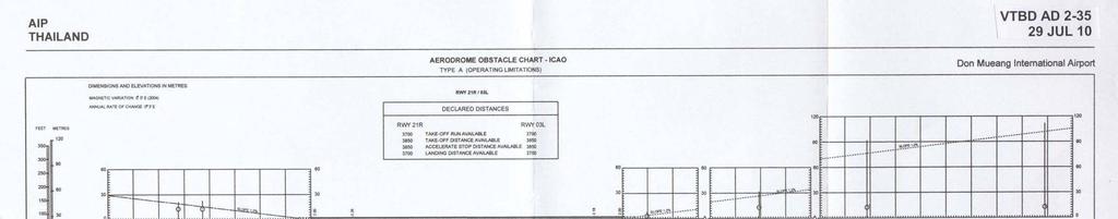
107
108 GEN AIP 29 JUL 10 THIS PAGE INTENTIONALLY LEFT BLANK
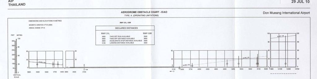
109
110 GEN AIP 29 JUL 10 THIS PAGE INTENTIONALLY LEFT BLANK

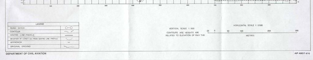
111
112 GEN AIP 29 JUL 10 THIS PAGE INTENTIONALLY LEFT BLANK
113 AIP VTBD AD JUL 1O GFS/FilS Rf{AV TRAratnoN r^ vel FLroo?ft4*$TroilArITUDE {t ARR$VAUTR tl{stnoil 000 TO FINAL APPROACII CTIART APP ARR TWR ATIS BANGKOKDon Mueang Intl RUrff 2rU21R AftIH,E 1A EETTY # PAUI-A I'A r--filobef---1 lrsro.sr,r rqdi?se i + FLY.8Y \I1FT g E'n -l Fr o otr'-o\ \ 2300.i MSA 25NM DVOR/DME BKK {ra' /ai m" A{84,8346, R474, \ rp, \^nl Clearance limit BETTY R4t!8, G463, Al Clearanco limit ANNIE 8t N t I BDGI* {N tbtt.ttg AT OR ABOVE 7ffi MAX 240IA8 1@7.50E BD2A AT OR ABOVE 80ffi 1ff-56N 1ffi7.78E t ru( 210 ras MH[,f o FLlSo MAX?40 As 69, ANNIE 1{G}.SN t@t2rse AT OR ABOVE gffi 8lD2ffi t1 rm40_8e EETTY ATOf,A8fi/tE 0OOO /1418.&N 1W2.768 Ll/ 1,406.?ell,9^/* tooas.m* # imn N f PA_yL4 4el*=- PAUTA 13{},2flN 1(Ip3.18E AT OR ABOVE 9W w BANGKOK vor Ot\C '111.7 tsangkok 4464, G459, M751, W10, W31 lalorl_j_s_#l _\." ur' \ rrego$i I ram.or I Lrffi6.iEJ Non - GP$/FMS RNAV egtrlppcd aftrafr will be glvon nadar vecdors on PSJFMS. CLEARANCE PHR/\STEOLO Y t. "Clegred xxx Tnansfiiln" Tnansfiirn" : Authortalion to fry the fateral GPS / FMS - Route; afrltude ard epoad asoignmant will be lssued by ATC. 2. "Gleared xlar Transfilon and Prolila" : Arrtroftrtlort to ny &s GPg / FM$ - Route ao puhldred, hcludlng the verlical canstralnte dopided on lhe puodun. 3.'Clesrsd..(Type)...npproodl" : Authortsathn to exesrts thp lruffument approadr vie tha partierlar cps/fms-route. Department of Givil Aviation
114 GEN AIP 29 JUL 10 THIS PAGE INTENTIONALLY LEFT BLANK
115 AIP VTBD AD JUL 1O GPS'FMS RNAV ARRMAI-TTRANSITION TO FIIIIAL APPROACH GTIAKT TRAl AfiPN I5/ELFLiTO TRAtrrffp0tAln?t o fi 000tt APP ARR TWR ATIS BANGKOK/Don Mueang Intl RWY 21U2IR CANDY 4A BEARING AT'ID TRACKS ARE ft.agnenc, AI-TITUDES IN FEET MSL q\ A 41, A292, G474, W1 CIearance limit CAIIDY 6{$" r{f;: -KORAT vor ow filr Knr =3? r07.7E 015'-"'t* \ 2300 ) MSA 25NM DVOR/DME BKK r406.?er,r 1004r16F r4f3.o6n 1S58428 AT OR ABOVE 7!ffi HAX 240IAS MNM 170 ras 1S41.76E BANGKOI{ LOffi tgt - Bl( ::_' It68,7trl { _-- GPSffMS RNAV OPTIONAL ROUTES BY ATC ONLY + FLy - By vlrft _ BANGKOK_ VORJDITE 117:I BKN =!= GH 17tX 13C3.6H { IffiTOEoGI L rgl arbd xnr Tmneition" : Attthothlionto fryhs I lateml GPS / FM$ - Route; aftitud'e and opeed I a*lgnment wlll b bqred by ATC. I 2. "Cteared rmt Tranoition and Proflle" : Authodation to I fryfte GPS / FMS - Rotfro as publlefred, lncludirrg th verilcal ontfilintt dopldsd on tte pmmduru. I 3. s0laared..f[ype)...ailfrond1' : Authofization to I exacute tho in${rumsnt appmacfi vla the particular GPS / FMS - Route. I Department of Givil Aviation
116 GEN AIP 29 JUL 10 THIS PAGE INTENTIONALLY LEFT BLANK
117 AIP VTBD AD JUL 1O INSTRUMENT AERODROMELEV 9 FT APPROACH HEIGHTS RELATED To CHART - ICAO AERoDRoMELEV APP : TWR : GND : 121.9, ATIS : 126.4,344.6 BANGKOK / Don Mueang Intl (WBD) NDB RWY2lL 14" 10' N BRG are MAG ELEV, ALT and HGT in FEET DIST in NM VAR O'42'W (2008) d \]j \ 4 \7a I J \?,\o. o d. z. I F z I I o$f \ Y300! MSA 25NM From BK NDB (LOM) 14" 00' N BANGKOK NDB (LOM) BK 293 khz N E 13" 50' N i 13.5 l :i11pti) 'tj,r:'t i:,i # i4 {} N # I "ry SCALE 1 : s 10 KM W N M 1 ooo 30' E 1oo" 40'E looo 50'E MISSED APPROACH : Climb straight ahead to 800ft then turn right continue climbing to 3000 ft and hold at NDB (LOM) or as directed by ATC. ELEV 8 (THR RW11 2tL) NM FM THR 21L MAPt \ ttb oo6"' (1 4e1) Straight - in approach 470 (461) FAF-MAPI 4.8 NM (min.s) Circling 700 (6e 1 ) Bo0 (7e1) Rate of descent (ftlm in)
118 VTBD AD JUL 10 AIP INSTRUMENT AERODROM ELEV 9 FT APPROACH HEIGHTS RELATED TO CHART - ICAO AERODROME ELEV APP : 119.4,254.6 TWR : 118.1,236.6 GND : 121.9, ATIS :126.4,344.6 BANGKOK / Don Mueang Intl (VTBD) NDB RWY2lR o ' N 14" 00' N BRG are MAG ELEV, ALT and HGT in FEET DIST in NM VAR O'42'W (2008) d. z. F z.! T L is*u" R BANGKOK NDB (LOM) BK 293 khz N E Q;\ MSA 25NM From BK NDB(LOM) Ft i;ai.ii.'l 13" 50' N N M 1 oo" 30' E looo 40'E looo 50' E MISSED APPROACH : Climb straight ahead to 800ft then turn right continue climbing to 3000 ft and hold at NDB (LOM) or as directed by ATC. ELEV 7 (THR RW1z 2tR) NM FM THR 2lR (1 4e1) Straight - in approach 470 (461) FAF_MAPI 4.8 NM (min:s) Circling 700 (6e1) 800 (7e1) Rate of descent (ft/min)
119 AIP VTBD AD JUL 1O INSTRUMENT AERODROM ELEV 9 ft APPROACH HEIGHTS RELATED TO CHART - ICAO AERODROMELEV 'E 10oo 30'E APP : 119.4,2U.6 ARR : TV1/R :118.1,236.6 GND : 121.9,122.5,257.8 ATIS : 126.4,U " 40'E BANGKOK / Bangkok INTL VOR RWY 21R 10oo 50'E 140 1o' N ' N ' N 4BRG are MAG ELEV, ALT and HGT in FEET DIST in NM \? \E \Nry, al al ru E oz l' R D BKK il---*-*' pf 14 ol&2 N.n*" j E * a / / J i w g l o i i r roi o i i \ {1' i, 2C, Gffi -..K : {:.: ;1fi..:.:.: ':.,,.v.\, "q ^ ;:;.' '.'.'.'.'.'.'.'. \... r i.t. ;[11126) ,.\ :.:.:.tiemokdx:ci.ti.:.t.i u,"tz \,"'*ni.'i.'.' l' :: ; :F;.;:;/-{'1, looo 20'E,,r,r,"Yl',kfu MISSED APPROACH Climb straight ahead to DVOR/DME BKK until2dme BKK outbound then tum right continue climb on R-250 BKK to 3000 ft and hold at 15DME BKK or as directed by ATC. ELEV 7 (TTrR RWY 2rR) $ FAF 6] D, BKK N E * \. I BANGKbK DVORYDME BKK Mhz ch'124x N E" I IAF RONAL R D BKK N E' MSA 25NM FROM BKK DVOFYDME SCALE 1 : oo" 30'E Fffioddl looo 40'E 'E NM FM THR zlr DME FM DVOR/DME DVORYDME BKK 1.4 4'.8 10:0 15: olz KM NM IAF RoNAr OCA/H A I B c l D Distance (BKK) 4 DME 5 DME 6 DME Straight - in approach 520 (51 1) Altitude Ground spe d (cs) knot FAF.MAN 3.4 NM (min/s)2:02 1:42 1:27 1:171:081:01 Circling 700 (6e1) 800 (7e1) Rate of descent (fvmin) ' N ' N ' N
120 VTBD AD JUL 1O AIP INSTRUMENT APPROACH CHART - ICAO AERODROMELEV 9 ft HEIGHTS RELATED TO AERODROMELEV APP : 119.4,2U.A ARR : T\Ml :118.1.,236.6 GND : 121.9,'122.5,257.8 ATIS : 126.4,W.6 BANGKOK / Bangkok INTL VOR RUIIY 21L 100" 20'E 100" 30'E looo 40' E ' E 140 1o' N ' N ' N t 6l+ o.,,aa.-rrac tr f g-ll Bis?;i#""dHGr nreer \r r;i K F. l - / L lomebkkl \ i- lrequired I i*- t L **'-"1 (197 i'(l syi r i * L -25o-' t$\o.q gtio- lcl> "rri?l q;i!:x FAF 6.E D, BKK N v E re ff.'.':.':'.'..i:., :.:.:.:.:... I. - '.1.126) r\,-.,,.,..'.r IF 12.0 BKK 600 uz.g/ N E * MSA 25NM ROM BKK DVORYDME SCALE 1 : ' N 14" 00' N ' N roo" zo'e MISSED APPROACH : Climb straight ahead to DVORYDME BKK until2dme BKK outbound then tum right continue climb on R-250 BKK to 3000 ft and hold at 15DME BKK or as directed by ATC. ELEV 8 (THR RWY 21L) NM fm IITRzIL DME FM DVOR/DME looo 30'E FTToool 100" 40' E l t! looo so'e -()3gr FAF rf laf Dv.R,DME H, :"#ff BKK " i ' M A P t l l / 4 2 e s 1 ) i r*ffiaf li---.7':l.i;r" l '' --'' I : O I OCA/H A B c D Distance (BKK) 4DME 5DME 6DME Straight - in approach 520 (511) Circling Altitude (ft) Ground speed (GS) knot FAF+/API 3.2 NM (min/s)1:55 1:361:22 1:121:04 0:58 7oo (6e1) I 800 (7e1) Rate of descenl (fumin) Department of Givil Aviation
121 AIP VTBD AD JUL 1O II{STRUiGiTT APPROAGH CHART.ICAO lm'20 E ara I'AG ELEV, ALT and }GT In FEET Dl$T fn Nll o. var08w{zmr) AERODROM ELEV 9 ft }IEIGHT$ REI.ATEDTO AERODROM ELEV 100 to E. 19 nrttd APP: 119.1, '1.7, Tll\lR : 118.1,236.6 d8b n 1mr$E BAI{GKOK / Bangkok INTL VOR / ILg 'DME RVrtY 03L l E t 6 D, BKK, (t^s Mru( 160 Kr t\ 'i:t ALT E VTN I /"! r;1169 *-afiir^' DVOR DitE E -ffi-*r'o3l I MSA 25NM FROM BKK DVORyDME i IAF 6000 ".-*r...".-.1-" -al-* -i ttl 717 FEF-M 15' /+0' ll DYE FH O\OR mre Fu tfit NM FH TIIR 6 D 5 D o,i 0 7.J ffi s LtztoiltE I XD / *i- *'y' EII\I 7 ft APPROACH : Cllmb on truck 029-dir.ct to thc LLZ, DmE than cltmb on R-029 to 1500(1491) ft thcn turn right to DVOR BKK and continuing climb on R-240 to BKK 16 DtlF FtX 3000(2991) ft ond hold or or dlructad by RtC. 1. THIS PROCEDURE, DOB NOT INCLUOE INTERMEDUTIE SEGMEMT. 2. START AT 6D.BKK IAS.MAX 1gO KT FOR ARCTI{G.
122 VTBD AD JUL 1O AIP a 1J, ul N IHs7RUilEilT APPROACH CHART.ICAO roo'ao e "*r-*r-" AERODRONN ELEV 9 ft HEIGHTS REI-ATED TO AHNODROME ELEY 'r -.-r- *'t'-.- t00 ill E ''"1''"1""'1' r--- r--*r--"'?--"'1**'t'" ^ f---r"- G are HAG ELEV, ALT and HOT In FEET DIST ln t{m Ir var06w(20otl Ltzl DiiE*---.r It D. BXf( (ns ua( 1Bo Kr FoR 1d f{m APP: t19.1, , TllllR : tl8.{,236-g,: ;*ii.- t r189r il A ti88r X -.\,//r*! rffi*":a.pa f20g l (2oa, #l^(1"{r'1,0/x AF {DARNO} 7.J 0, t-bk n*211 Elfi ALT ITOO rt N 00$n t.l'l Er J BANGKOK I Bangkok INTL 'Sit,f" I f {''^irt#,ffi#i" I -\tlllr #.,lffil8::b$!?lo)x A zroffir SANGKOK.*.* DA,oR/DUE 117,7 EKK ch r24 X (2as) 1gl. russso.a x Liiiilr.,. '-l*n---* VOR'LLZ'DIIE RWY O3L E l4' o0' N scate CHtl too'ro'e IRANsnoN ALT VTFI 1 AL r "ciiit'- 8.r D, l-bl(o ta$ irar( t70 KT MSA 25NM FROM BKK DVOR/DME [-.-,r--.-,-*.-, *,-- --r.. -.4K1--i*-.-r..-= l-.-.,.--..' " -.*.r.--l--..r---r---r==.1.--,.1, r00 50 E IAF 1@-50 DVOR/DI1 E too'ro r BKK 6000 elt' -*IsdTr* R'o3t IsssJ rr' 40' N u.zme I KD a *1,* -'j / Et.E\' 7 tt mte il ut NU Flt ]}fr ++*.-s!+.ff -i-l z,s ED APPROACH : C6mb an trsck 0zg"dircct to thr LLZ, DUE than cllmb on R-029 to {600{149f} ft than tum right to BVOR BKK ond contlnulng cllmb on R-240 to BKK 16 DiJIE FtX {f I ond :-r-::r. hold or or dlructad by nfc..:fdlfiffi" A D (rzai) ;"'s,;;;;';l.o'*f *-- - -lt*t'; f ; (r,) It* Fto h '<- a '- * j:r..h' ri^, _"uo-l**-tr*lrniiioiluij ::Jpv*:f:::ft rrrell-li'*ii]*l ;"l*".:ri**:f f {-in frffieni( 1. SrAFr AT 60,BKK ras hrat( 180 Kr rur ARCrhflCl..*_--_""..*LJ.**.1*_J**_.l o 180 I 20D l:10 Department of Givil Aviation
123 AIP VTBD AD JUL 1O INSTRUMENT AERODROME ELEV 9 fr APPROACH HEIGHTS RELATED TO CHART - ICAO THR R\A/Y 21R - ELEV 7 fi 'E ' E APP : 119.4,2il.6 ARR : T\A/R : 118.1,236.6 GND : 121.9,122.5,257.8 ATIS : 126.4,W 'E BANGKOK / Bangkok INTL ILS or LLZ RVVY 21R (CAT ll) 10oo so,e ' N 140 0o' N ' N are MAG ELEV, ALT and HGT in FEET DIST ln NM 6 '.$BRG, 7 1 l7- t ),\* \\ o; \\- MSA 25NM FROM BKK DVOFYDME _LOC_ l-bkk Mhz N E' Y (Il! o I lo I.':$,fr i FAF 6.7 D, BKK 1600 LOM - I BK 293Khz Ira ss N E' - -LMM- KK 276Khz I 13 s N I E *l $il"- 100" 20'E WR2 ALT6A G'VD t t! MISSED APPROACH : Climb on Runway heading until2dme BKK outbound then tum right continue climb on R-250 BKK to 3000 ft and hold at 1SDME BKK oras directed by ATC. ELEV 7 (rt{r RWY 2lR).\$' \$'?l u,(s \ (19-t A 'A'i o++ "'.'fr.'.'.'.'.' -.'.". -:..'h,.. ' :.-./j'\ lllli2s)".:.. :'-'-'- : BANGKOK DVOR/DME BKK 117,7 MhZ ch 124X N E* E* IF R D BKK N * Non - Radar Procedure : Aircraft will be cleared to BKK VOR then transition to IAF (TAWAN) to carry out the ILS approach. VOR/DME BKK Required SCALE 1 00" 30' E looo 40'E 100o 50'E fia'11obol ITTffiI NM FM THR 2IR DME FM DVOR/DME 1: : IAF TAwAN 000 ee3) OCA/H A B c D Distance (BKK) 4 DME 5 DME 6 DME Straight - in approach CAT I 207 (200) Altitude (ft) CAT II 1 07 (100) Ground speed (GS) knot LLZ Only 380 (373) FAF-MAPI 3.8 NM (min/s)2:17 1:54 1:38 1:26 1:161:08 Circling 700 (6e3) 800 (7e3) Rate of descent (fumin) o' N ' N ' N
124 VTBD AD JUL 1O AIP 140 1o' N ' N ' N INSTRUMENT APPROACH CHART. ICAO looo 20'E "e\t AERODROMELEV 9 ft HEIGHTS RELATED TO THR R\AA/ 21L. ELEV 8 ft looo 30'E APP : 119.4,2il.6 ARR : T\flR :118.1,236.6 GND : 121.9,122.5,257.8 ATIS : 126.4,U4.A looo 40'E BRG are MAG ELEV, ALT and HGT in FEET ei\ DIST in NM 6,7 69 lz. \a VOR/DME BKK DME ( -DMG) Required - LOC I.DMG.on$ Mhz CH40X N E " Y Y, i oi i oi! roi i F t I Grffi i \ (,t WR2 etr a od -Ttr,)l t ri-i o0' 20' E MISSED APPROACH : Climb on Runway heading until2dme BKK outbound then tum right continue climb on R-250 BKK to 3000 ft and hold at 15DME BKKoras directed by ATC. ELEV 8 THR RWY 21L K r.,l >.'!i.'.'.t /.'.'.'..t* '-'/ -'-';l(-' looo 30'E hlemfistl NM FM THR 2IL riurerm DVoR/DME DMEFMIIZ 1C7,.1.*ff.' :..'.'.'-'"r., \,s BANGKOK / Bangkok INTL ILS or Ll-Z. RVI Y 21L looo so'e / +s,s rfb ) *5r Y 14fi* STARS, 17.1 D BKK N ^s' lf 1oo 44 oa.gs e?v R D BKK , 11.8 p_ I-DMG *t.* MSA 25NM FROM BKK DVORYDME i$'.ffi',t. :vta t dffi-uuof?e"om -a i!; ' tj.ilu.iz7) 1'/'teo: : :':j\''^.'..'...:':t. '. '. '. '. '. ' _ '. '. ' '. '. '. t '::: ;ArVGl('9 K.C ITY:..',-'...-t"'...1.:-.1'ql-. l.., -r'l'\tll'1', 1600 I gxr VoR then transition 13se38.47N l:,^ rbo si ;.ri'l. to taf (srars) to carry I outthe ILS approach. {\,. BANGKOK -----""'l DVORYDME BKK Mhz,;E: ch 124X \./\ N For-l E* looo 40'E 1O0o SO' E fretbbo.,r-029 FAF IAF : d STARS eez) OCA/H A B c D Distance (l-dmg) 4DME 5DME 6DME Straight - in approach CAT I 208 (200) Altitude (ft) Ground speed (GS) knot LLZ Only 430 (422) FAF-IUAFI 3.5 NM (min/s)2:06 1:451:30 1:191:101:03 Circling 700 (6e2) I 800 (7e2) Rate of descent (fvmin) ' N ' N 13" 50' N Department of Givil Aviation
125 AIP VTCC AD JUL 10 VTCC AD 2.8 APRONS, TAXIWAYS AND CHECK LOCATIONS/POSITIONS DATA 1 Apron surface and strength South Apron Aircraft Stand NR 1-14 Surface : Concrete Strength : PCN 78/R/C/X/T South Apron Aircraft Stand NR Surface : Concrete Strength : PCN 62/R/B/X/T 2 Taxiway width, surface and strength - Taxiway A Width : 27 m., Surface : Concrete, PCN 70/R/B/W/T - Taxiway B, C, E, G, P5 and P6 Width : 23 m., Surface : Asphalt, PCN 59/F/A/X/T - Taxiway D (Rapid Exit Taxiway) Width : 25 m., Surface : Asphalt, PCN 85/F/C/Y/T - Taxiway F, H and Q Width : 23 m., Surface : Concrete, PCN 88/R/D/X/T - Taxiway P Width : 23 m., Surface : Concrete, PCN 88/R/D/X/T Width : 23 m., Surface : Asphalt, PCN 59/F/A/X/T 3 Altimeter checkpoint location and Nil elevation 4 VOR checkpoints Nil 5 INS checkpoints Nil 6 Remarks Nil VTCC AD 2.9 SURFACE MOVEMENT GUIDANCE AND CONTROL SYSTEM AND MARKINGS 1 Use of aircraft stand ID signs, TWY guide lines and visual docking/parking guidance system of aircraft stands Taxiing guidance signs at all intersections with TWY and RWY and at all holding positions. Nose-Wheel guide lines at apron. Solid Nose-Wheel guide lines at aircraft stands. Nose-in guidance at aircraft stands. Safegate Docking System at stand number 4, 5, 6, 7 and 8. 2 RWY and TWY markings and LGT RWY marking : RWY Designation, THR, TDZ, Center line, Aiming Point and Side Stripe RWY LGT : THR, RWY Edge and RWY End lights TWY marking : Center line, Edge, RWY Holding Positions and Intermediate Holding Positions TWY LGT : TWY Edge lights 3 Stop bars Stop bars where appropriate 4 Remarks Nil


 The SBU message The message STOP SBU means that docking has been interrupted and has to be resumed only by manual guidance. Do not try to resume docking without manual guidance. 2.")
126 VTCC AD DEC 08 AIP 1 INTRODUCTION SAFEGATE DOCKING SYSTEM IN SYSTEM AT CHIANG MAI INTL AIRPORT 1.1 The SAFEGATE Docking System in system is install at bay 4, 5, 6, 7 and The system enables the pilots seated on the left of the cockpit to position his aircraft on the correct stand centre line and stop position 2 PILOT OPERATING INSTRUCTION 2.1 Safety procedure a) General warning The DGS system has a built-in error detection program to inform the aircraft pilot of impending dangers during the docking procedure. If the pilot is unsure of the information, being shown on the DGS display unit, he must immediate stop the aircraft and obtain further information for clearance. b) Item to check before entering the stand area Warning : The pilot shall not enter the stand area, unless the docking system first is showing the vertical running arrows. The pilot must not proceed beyond the bridge, unless these arrows have been superseded by the closing rate bar. Warning : The pilot shall not enter the stand area, unless the aircraft type displayed is equal to the approaching aircraft/ The Correctness of other information, such as door 2, shall also be checked. c) The SBU message The message STOP SBU means that docking has been interrupted and has to be resumed only by manual guidance. Do not try to resume docking without manual guidance. 2.2 START-OF-DOCKING The system is started by pressing one of the aircraft type buttons on the operator panel. When the button has been pressed, WAIT will be displayed. 2.3 CAPTURE The floating arrows indicate that the system is activated and in capture mode, searching for an approaching aircraft. If shall be checked that the correct aircraft type is displayed. The lead-in line shall be followed. The pilot must not proceed beyond the bridge, unless the arrows have been superseded by closing rate bar. 2.4 TRACKING When the aircraft has been caught by the laser, the floating arrow is replaced by the yellow centre line indicator. A flashing red arrow indicates the direction to turn. The vertical yellow arrow shows position in relation to the centre line. This indicator give correct position and azimuth guidance. 2.5 CLOSING RATE Display of digital countdown will start when the aircraft is 20 meters from stop position. When the aircraft is less than 12 meter from the stop position, the closing rate is indicated by turning off one row of the center line symbol per 0.5 metres, covered by the aircraft. Thus, when the last row is turned off, 0.5 metre remains to stop.
127 AIP VTCC AD JUL 10 VTCC AD 2.10 AERODROME OBSTACLES In approach/tkof areas In circling area and at AD Remarks RWY NR/Area affected Obstacle type Elevation Markings/LGT Coordinates Obstacle type Elevation Markings/LGT Coordinates a b c a b TKOF RWY 36/ APCH RWY 18 - Building HGT 370 m. MSL - Building HGT m. MSL Mountain North West of Aerodrome See Aerodrome Obstacle Chart Type A See Aerodrome Obstacle Chart Type B VTCC AD 2.11 METEOROLOGICAL INFORMATION PROVIDED 1 Associated MET Office Aeronautical Radio of Thailand Company Ltd. Airport of Thailand Public Company Ltd. Thai Airways International Public Company Ltd. 2 Hours of service Met Office outside hours H24 3 Office responsible for TAF preparation Periods of validity 4 Trend forecast Interval of issuance 5 Briefing/consultation provided Yes 6 Flight documentation English Language (s) used Supply TAF from Northern Regional MET Center issue TAF on standard time 00, 06, 12, 18 UTC observe METAR every half an hour issue Trend Type Landing Forecast Supply TAF from Northern Regional MET. Center Issue TAF on standard time 00, 06, 12,18 UTC Observe METAR every half an hour Issue Trend Type Landing Forecast 7 Charts and other information available for briefing or consultation 8 Supplementary equipment available for providing information Daily Weather Forecast Upper wind levels 850, 700, 500, 300, 200 hpa. SIG.WX.Chart AWOS, Radar 9 ATC units provided with information ATS Workstation 10 Additional information (limitation of IP System service, etc.)
128 VTCC AD JUL 10 AIP VTCC AD 2.12 RUNWAY PHYSICAL CHARACTERISTICS Designations RWY NR TRUE BRG Dimensions of RWY (m) Strength (PCN) and surface of RWY and SWY THR coordinates RWY end coordinates THR geoid undulation THR elevation and highest elevation of TDZ of precision APP RWY x x45 59/F/A/X/T Asphaltic Concrete 70/R/B/W/T Conrete ( Displacement ) 59/F/A/X/T Asphaltic Concrete N E (WGS-84) N E (WGS-84) THR m/ ft THR m/ 1007 ft Slope of RWY-SWY SWY dimension CWY dimension Strip dimension OFZ Remarks % -0.06% -0.53% -0.32% -0.05% -0.04% 0% 100x45 Nil 3 620x150 Nil Nil (300m 674m 1241m 1719m 2517m 3000m 3400m) 0% +0.04% +0.05% +0.32% +0.53% +0.06% Nil Nil 3320x150 Nil Nil (400m 883m 1681m 2159m 2726m 3100m) VTCC AD 2.13 DECLARED DISTANCES RWY Designator TORA TODA ASDA LDA Remarks (m) (m) (m) (m) Nil Nil
129 AIP VTCC AD JUL 10 RWY Desig nator APCH LGT type LEN INTST THR LGT colour WBAR VTCC AD 2.14 APPROACH AND RUNWAY LIGHTING VASIS (MEHT) PAPI TDZ, LGT LEN RWY Centre Line LGT Length, spacing, Colour, INTST RWY edge LGT LEN, spacing colour INTST RWY End LGT colour WBAR SWY LGT LEN (m) colour Remarks SALS 420 m LIH Green PAPI Left/Right 3 (60 ft) Nil Nil m 60 m White;LIH Red Nil Nil 18 SALS Green PAPI Nil Nil m Red 100 Nil 420 m Left/Right 60 m LIH 3 (60 ft) White;LIH VTCC AD 2.15 OTHER LIGHTING, SECONDARY POWER SUPPLY 1 ABN/IBN location, characteristics and hours of operation ABN : At Tower building, FLG W G EV 7 SEC IBN : Nil As AD Administration 2 LDI location and LGT Anemometer location and LGT Wind Cone near right PAPI 36, illuminated Anemometer : nil 3 TWY edge and centre line lighting EDGE : All TWY Centre Line : Nil 4 Secondary power supply/switch-over time Secondary power supply to all lighting At AD switch-overtime : 15 SEC 5 Remarks Nil
130 VTCC AD DEC 08 AIP VTCC AD 2.16 HELICOPTER LANDING AREA 1 Coordinates TLOF or THR of FATO Nil Geoid undulation 2 TLOF and/or FATO elevation M/FT Nil 3 TLOF and FATO area dimensions, Nil surface, strength, marking 4 True BRG of FATO Nil 5 Declared distance available Nil 6 APP and FATO lighting Nil 7 Remarks Nil VTCC AD 2.17 ATS AIRSPACE 1 Designation and lateral limits A circle of 5 NM radius centered on N E 2 Vertical limits 5000 ft/agl 3 Airspace classification C 4 ATS unit call sign Language(s) Chiang Mai Tower En, Thai 5 Transition altitude ft 6 Remarks Nil
131 AIP VTCC AD JUL 10 VTCC AD 2.24 CHARTS RELATED TO THE AERODROME Page Aerodrome Chart ICAO VTCC AD 2-21 Aircraft Parking/Docking Chart ICAO VTCC AD 2-23 Aerodrome Ground Movement Chart ICAO VTCC AD 2-25 Aerodrome Obstacle Chart ICAO Type A-RWY 18/36 VTCC AD 2-27 Area Chart ICAO VTCC AD 2-29 Standard Instrument Departure Chart RWY 18 VTCC AD 2-31 Standard Instrument Departure Chart RWY 18 VTCC AD 2-32 Standard Instrument Departure Chart RWY 36 VTCC AD 2-33 Standard Instrument Departure Chart RWY 36 VTCC AD 2-34 Standard Departure Chart Instrument - ICAO VTCC AD 2-35 Standard Departure Chart Instrument - ICAO VTCC AD 2-36 Instrument Approach Chart ICAO RWY 36 NDB VTCC AD 2-37 Instrument Approach Chart ICAO RWY 36 VOR VTCC AD 2-39 Instrument Approach Chart ICAO RWY 36 NDB / DME VTCC AD 2-41 Instrument Approach Chart ICAO RWY 18/36 NDB / DME VTCC AD 2-42 Instrument Approach Chart ICAO RWY 36 VOR / DME VTCC AD 2-43 Instrument Approach Chart ICAO RWY 18/36 VOR / DME VTCC AD 2-44 Instrument Approach Chart ICAO RWY 36 ILS or LLZ VTCC AD 2-45
132 VTCC AD 2-20 AIP THIS PAGE INTENTIONALLY LEFT BLANK
 DME ( CMA) Required 18\" 40' N")
133 AIP INSTRUMENT AERODROMELEV. 'I036 ft APPROACH HEIGHTS RELATED TO CHART - ICAO THR RWY 36 ELEV ft APP : '129.6, TWR: 118.1, GND : 121.9,275.8 ATIS :127.2,301.5 CHIANGNIAI / Chiangmai INTL ILS or LLZ RV\ / 36 VTCC AD JUL 10 18" 50' N 98" 50' E 99' 00' E 99' 1o' E : l r r r l VT D41 UNL GND I 18' - 50' - N vor/dme (CMA) DME ( CMA) Required 18" 40' N 18" 40' N 5 z 18' 30' N : / t F I4.G D ICMA 13.5 D, R- t80 CMA ALT 35OO KM ib N E* NM,/ 18' 30' N [,4SA 25 Nt\,4 FROM CMA OVOR/DME 98' 50' E l\,llssed APPROACH : MAX IAS 200 Kt until sfrer tum. './ TOONY 24"0D,R.162CM D ICMA...:-i ).,..,,_..tsszz,rlrj,b:jf " E' r r i l l r t t t : r 1 99' 00' E MAft LIZ ONLY LLZDME tc A FAP (FAF eerlroe) 99" 10'E IF ELEV 1007 ft. StEight - in DME FM LLZ DME :,^ ^. u r.v S ocr',/h B c D Dislance (lcma) 4D 5D 6D 7D 8D 9D CAT I 1348 (341) 1358 (351) 1368 (361) 1378 (371) Alttude (Height) (723)( ( I (1998I( (GS) knot r LLZ Only 1500 (493) '1060 Circlng 2100 (1064) 2200 (1164) lmin/s)3.47 3r0g 2:42 2'.22 2:06 1:53 REMARK: Circling to the Right (East ofaefodfome) only.
134 AIP THIS PAGE INTENTIONALLY LEFT BLANK
135 AIP VTCT AD JUL 10 VTCT AD 2. AERODROMES VTCT AD 2.1 AERODROME LOCATION INDICATOR AND NAME VTCT- CHIANG RAI / MAE FAH LUANG-CHIANG RAI INTERNATIONAL AIRPORT VTCT AD 2.2 AERODROME GEOGRAPHICAL AND ADMINISTRATIVE DATA 1 ARP coordinates and site at AD N E Center Line of RWY, 1500 M from THR RWY21 2 Direction and distance from (city) 9 KM, NE from city 3 Elevation/Reference temperature M (1280 FT ) / 35º C 4 MAG VAR/Annual change 0º 12' W(2001)/3' E 5 AD Administration, address, telephone, telefax, telex, AFS 6 Types of traffic permitted (IFR/VFR) IFR/VFR 7 Remarks Nil Director of Mae Fah Luang-Chiang Rai Airport Mae Fah Luang-Chiang Rai International Airport 404 Chiang Rai-Maechan Road Rimkok-Baan Doo Sub-District Amphoe Muang, Chiang Rai Thailand Tel , Fax AFS: VTCTYDYX VTCT AD 2.3 OPERATIONAL HOURS 1 AD Administration , after this period 1 HR PN to ATC 2 Customs and immigration Customs: Available Immigration: Available 3 Health and sanitation Available on request 4 AIS Briefing Office ATS Reporting Office (ARO) - 6 MET Briefing Office - 7 ATS Fuelling H24 9 Handling Security
136 VTCT AD DEC 08 AIP VTCT AD 2.4 HANDLING SERVICES AND FACILITIES 1 Cargo-handling facilities Not available 2 Fuel/oil types Jet A-1 3 Fuelling facilities/capacity 1 Jet A-1 12,000 L 4 De-icing facilities - 5 Hangar space for visiting aircraft Not available 6 Repair facilities for visiting aircraft Not available 7 Remarks Nil VTCT AD 2.5 PASSENGER FACILITIES 1 Hotels In the city 2 Restaurants Available at the airport and in the city 3 Transportation Limousines 4 Medical facilities First aid at AD hospitals in the city 5 Bank and Post Office Bank: open from Tourist Office Available at the airport 7 Remarks Nil VTCT AD 2.6 RESCUE AND FIRE FIGHTING SERVICES 1 AD category for fire fighting Category 8 2 Rescue equipment Yes 3 Capability for removal of disabled aircraft - 4 Remarks Nil VTCT AD 2.7 SEASONAL AVAILABILITY-CLEARING 1 Types of clearing equipment - 2 Clearance priorities - 3 Remarks The aerodrome is available all seasons. VTCT AD 2.8 APRONS, TAXIWAYS AND CHECK LOCATIONS DATA 1 Apron surface and strength Surface: Concrete Strength: PCN 73/R/D/X/T 2 Taxiway width, surface and strength Width: 23 M Surface: Asphaltic Concrete Strength: PCN 84/F/D/X/T 3 ACL location and elevation Location: At Apron Elevation: M
137 AIP VTCT AD JUL 10 VTCT AD 2.20 LOCAL TRAFFIC REGULATIONS In order to avoid confusion between Mae Fah Luang-Chiang Rai International Airport and Chiang Rai Military Aerodrome (195312N E) located on R-218 distance approximate 5 NM of Mae Fah Luang-Chiang Rai International Airport aircraft are to take caution while landing.
138 VTCT AD DEC 08 AIP VTCT AD 2.21 NOISE ABATEMENT PROCEDURES NIL VTCT AD 2.22 FLIGHT PROCEDURES NIL VTCT AD 2.23 ADDITIONAL INFORMATION NIL
139 AIP VTSP AD DEC 08 VTSP AD 2. AERODROMES VTSP AD 2.1 AERODROME LOCATION INDICATOR AND NAME VTSP - PHUKET / PHUKET INTERNATIONAL AIRPORT VTSP AD 2.2 AERODROME GEOGRAPHICAL AND ADMINISTRATIVE DATA 1 ARP coordinates and site at AD N E Centre of runway 660 m from THR RWY 09 2 Direction and distance from (city) 32 km (NW) 3 Elevation/Reference temperature 25 m (82 ft) 33 C 4 Geoid undulation at AD ELEV PSN Nil 5 MAG VAR/Annual change 0 18 W (2001) / 3 E 6 AD Administration, address, telephone, telefax, telex, AFS 7 Types of traffic permitted (IFR/VFR) IFR/VFR 8 Remarks Nil Phuket International Airport Airport of Thailand Public Company Limited Phuket 83111, Thailand Tel Fax AFS : VTSPYDYX VTSP AD 2.3 OPERATIONAL HOURS 1 AD Administration H24 2 Customs and immigration H24 3 Health and sanitation H24 4 AIS Briefing Office H24 5 ATS Reporting Office (ARO) H24 6 MET Briefing Office H24 7 ATS H24 8 Fuelling H24 9 Handling H24 10 Security H24 11 De-icing Nil 12 Remarks Nil
140 VTSP AD JUL 10 AIP VTSP AD 2.4 HANDLING SERVICES AND FACILITIES 1 Cargo-handling facilities Thai Airways International Public Co,Ltd. / TAGS 2 Fuel/oil types JET A-1, AVGAS 100LL : Hydrant System 3 Fuelling facilities/capacity Refuel Jet A-1 : Tank TTL 1,400,000 LTRS Jet A-1 : 2 Trailers TTL 24,000 LTRS AVGAS 100LL : 1 Tank TTL 3,000 LTRS AVGAS 100LL : 1 Trailer TTL 3,000 LTRS 4 De-icing facilities Nil 5 Hangar space for visiting aircraft Nil 6 Repair facilities for visiting aircraft Nil 7 Remarks Nil VTSP AD 2.5 PASSENGER FACILITIES 1 Hotels In the city 2 Restaurants At AD and In the city 3 Transportation Limousines and taxis 4 Medical facilities First aid at AD and hospitals in the city 5 Bank and Post Office At AD open within AD HR 6 Tourist Office Office in the city Tel Fax Remarks Nil VTSP AD 2.6 RESCUE AND FIRE FIGHTING SERVICES 1 AD category for fire fighting Category 9 2 Rescue equipment Facility of Category 9 is provided 3 Capability for removal of disabled Available Up to B747 aircraft 4 Remarks Nil VTSP AD 2.7 SEASONAL AVAILABILITY CLEARING 1 Types of clearing equipment - 2 Clearance priorities - 3 Remarks The aerodrome is available all seasons
141 AIP VTSP AD JUL 10 VTSP AD 2.8 APRONS, TAXIWAYS AND CHECK LOCATIONS/POSITIONS DATA 1 Apron surface and strength Surface : Concrete Strength : PCN 78/R/C/X/T 2 Taxiway width, surface and strength - Taxiway A, B, E, F and G Width : 30 m., Surface : Concrete, PCN 78/R/C/X/T - Taxiway C Width : 30 m., Surface : Asphalt, PCN 59/F/A/X/T - Taxiway D Width : 23 m., Surface : Asphalt, PCN 59/F/A/X/T - Taxiway P Width : 23 m., Surface : Asphalt and Concrete, PCN 59/F/A/X/T and PCN 78/R/C/X/T 3 Altimeter checkpoint location and Location : At Apron elevation Elevation : 5.18 m / 17 ft 4 VOR checkpoints Nil 5 INS checkpoints See AD Chart 6 Remarks Nil VTSP AD 2.9 SURFACE MOVEMENT GUIDANCE AND CONTROL SYSTEM AND MARKINGS 1 Use of aircraft stand ID signs, TWY guide lines and visual docking/parking guidance system of aircraft stands Taxiing guidance signs at all intersections with TWY and RWY Nose-Wheel guide lines at apron. Solid Nose-Wheel guide lines at aircraft stands. Nose-in guidance at aircraft stands. RLG Docking System at stand number 4, 8, 9 and 10. Safegate Docking System at stand number 5, 6 and 7. 2 RWY and TWY markings and LGT RWY marking : RWY Designation, THR, TDZ, Center line, Aiming Point and Side Strip RWY LGT : THR, RWY Edge and RWY End lights TWY marking : Center line, Edge and RWY Holding Position TWY LGT : TWY Edge lights 3 Stop bars Stop bars where appropriate 4 Remarks Nil

142 VTSP AD DEC 08 AIP 1. INTRODUCTION RLG DOCKING SYSTEM IN SYSTEM AT PHUKET INTL AIRPORT The RLG docking system in system is install at bay 4, 8, 9 and 10 The system enables the pilots seated on the left of the cockpit to position his aircraft on the correct stand centre line and stop position 2. PILOT OPERATING INSTRUCTIONS The pilot or co-pilot simply follows the center azimuth steering bars to keep the aircraft at the center, and to keep the aircraft to a reasonable speed. The azimuth indication consists of a central green bar and two red bars one to each side of the green bar. The center green bar will always be on, while the red side bars will only come on, one at a time, when the aircraft is off center If the aircraft veers to far to the right, the right red bar will come on, along with the center green bar. Conversely, if the aircraft veers too far to the left, the left red bar will come on, along with the center green bar. The pilot would simply steer towards the green bar to get back to the center J-line. When the aircraft is more than 30 meters away from the docking position, the only indications will be the aircraft type displayed on the first display line, and the azimuth bar(s) at lower center of the Pilot Display unit Starting at 30 meters, the close-in distance will be displayed on the second display line, along with the progress meter at the lower left corner of the Pilot Display unit. The close in distance will be updated in 1 meter increments. Starting at 10 meters, the close-in distance will be displayed in 0.2 meter increments. If the aircraft is moving too fast, the Aircraft Display unit will let the pilot know by displaying the message 2 FAST. The pilot should slow down the aircraft until the 2 Fast message disappears. If the incoming aircraft does not match the expected aircraft (shown on the top line of display) the message NO ID will immediately be displayed on the first line, and the message STOP, in red, on the second line of display. The pilot must stop the aircraft immediately, and follow any instructions from the ground crew. If the aircraft overshoots and moves beyond the designated docking position, the Aircraft Display will display the message 2 FAR to indicate the over travel. The pilot should also stop the plane immediately if this happens. RLG system parking sequence a) In this picture the aircraft is at a distance greater than 30 meters from the parking position and is directly at the center line. Note that the progress bar and digital close-in distance are not displayed when the aircraft is greater than 30 meters away from the docking position. A Boeing 747 aircraft is expected. b) In this picture the aircraft is exactly 30 meters from the docking position, but is off to the right of the center line. Starting at 30 meters, the digital close-in distance (second line of display) is displayed, in 1 meter increments. The progress meter (lower left) will also be activated at this distance.

143 AIP VTSP AD DEC SYSTEM BREAKDOWN In case of a severe system failure, the display will go black, except for a red stop indicator. A manual backup procedure must be used for docking guidance POWER FAILURE In case of a power failure, the display will be completely black. A manual backup procedure must be used for docking guidance.
144 VTSP AD JUL 10 AIP VTSP AD 2.10 AERODROME OBSTACLES In approach/tkof areas In circling area and at AD Remarks RWY NR/Area affected Obstacle type Elevation Markings/LGT Coordinates Obstacle type Elevation Markings/LGT Coordinates a b c a b TKOF RWY 09/ APCH RWY 27 Mountain HGT 138 m.msl See Aerodrome Obstacle Chart Type A, B Transitional Surface - Mountain 141 m.msl Inner Horizontal Surface - Mountains 130, 268 and 210 m.msl (North) - Mountains 141, 120, 139 and 225 m.msl (South) Conical Surface - Mountains 295 and 335 m. MSL See Aerodrome Obstacle Chart Type B VTSP AD 2.11 METEOROLOGICAL INFORMATION PROVIDED 1 Associated MET Office Aeronautical Radio of Thailand Ltd. Airports of Thailand Public Company Ltd. Thai Airways International Public Company Ltd. 2 Hours of service Met Office outside hours H24 3 Office responsible for TAF preparation Periods of validity 4 Trend forecast Interval of issuance 5 Briefing/consultation provided Yes Supply TAF from Southern (WestCoast) Regional MET center. Issue TAF on standard time 00, 06, 12, 18 UTC Issue METAR every half an hour Observe SPECI off standard time Issue Trend Type Landing Forecast Supply TAF from Southern (Westcoast) Regional MET center. Issue TAF on standard time 00, 06, 12, 18 UTC Issue METAR every haft an hour Observe SPECI off standard time Issue Trend Type Landing Forecast 6 Flight documentation Language (s) used 7 Charts and other information available for briefing or consultation 8 Supplementary equipment available for providing information English Daily Weather Forecast Upper wind levels 850, 700, 500, 300, 200 hpa. SIG.WX.Chart AWOS, Radar 9 ATC units provided with information ATS Workstation 10 Additional information (limitation of service, etc.) IP system
145 AIP VTSP AD JUL 10 VTSP AD 2.12 RUNWAY PHYSICAL CHARACTERISTICS Designations RWY NR TRUE BRG Dimensions of RWY (m) Strength (PCN) and surface of RWY and SWY THR coordinates RWY end coordinates THR geoid undulation THR elevation and highest elevation of TDZ of precision APP RWY x45 59/F/A/X/T N THR m/19 ft 085 MAG Asphaltic Concrete E MAG 3000x45 59/F/A/X/T Asphaltic Concrete N E THR m/81.8 ft Slope of RWY-SWY SWY CWY Strip OFZ Remarks dimension dimension dimension % +0.01%+1.0%+0.08% (500m 1000m 2500m 3000m) 60x45 Nil 3240x150 Nil Nil -0.80% -1.0% -0.01% -0.12% (1000m 2000m 2500m 3000m) 60x45 Nil 3240x150 Nil Nil VTSP AD 2.13 DECLARED DISTANCES RWY Designator TORA* TODA* ASDA* LDA Remarks (m) (m) (m) (m) Nil Nil
146 VTSP AD JUL 10 AIP RWY Desig nator APCH LGT type LEN INTST THR LGT colour WBAR VTSP AD 2.14 APPROACH AND RUNWAY LIGHTING VASIS (MEHT) PAPI TDZ, LGT LEN RWY Centre Line LGT Length, spacing, Colour, INTST RWY edge LGT LEN, spacing colour INTST RWY End LGT colour WBAR SWY LGT LEN (m) colour Remarks RTIL GREEN PAPI Left/Right 3 (64.07 ft ) Nil Nil 3000m, 60m WHITE : FM 2400m -3000m YELLOW : LIH RED Nil Nil 27 APCH LGT (5 BAR) 300 m LIH GREEN PAPI Left/Right 3.2 (64.96 ft ) Nil Nil 3000m, 60m WHITE : FM 2400m m YELLOW : LIH RED Nil Nil VTSP AD 2.15 OTHER LIGHTING, SECONDARY POWER SUPPLY 1 ABN/IBN location, characteristics and hours of operation ABN : On top of control tower FLG W G EV 4 sec. / IBN: Nil, H 24 2 LDI location and LGT Anemometer location and LGT LDI : Wind Cone near left PAPI 09, illuminated. Anemometer : See AD Ground Movement Chart 3 TWY edge and centre line lighting EDGE : All TWY CENTRE LINE : Nil 4 Secondary power supply/switch-over time RWY 27/09 Supplied by stands by generator switch over time 8 sec. 5 Remarks Nil
147 AIP VTSP AD JUL 10 VTSP AD 2.24 CHARTS RELATED TO AN AERODROME Page Aerodrome Chart- ICAO VTSP AD 2-23 Aircraft Parking/Docking Chart - ICAO VTSP AD 2-25 Aerodrome Ground Movement Chart - ICAO VTSP AD 2-27 Aerodrome Obstacle Chart - ICAO - Type A - RWY 09/27 VTSP AD 2-29 Aerodrome Obstacle Chart ICAO Type B-RWY 09/27 VTSP AD 2-31 Standard Instrument Departure Chart RWY 09 VTSP AD 2-33 Standard Instrument Departure Chart RWY 27 VTSP AD 2-34 Standard Instrument Departure Chart RWY 09/27 VTSP AD 2-35 Instrument Approach Chart - ICAO - RWY 09 VOR Y VTSP AD 2-37 Instrument Approach Chart - ICAO - RWY 27 VOR Y VTSP AD 2-38 Instrument Approach Chart - ICAO - RWY 09 VOR Z VTSP AD 2-39 Instrument Approach Chart - ICAO - RWY 27 VOR Z VTSP AD 2-40 Instrument Approach Chart - ICAO - RWY 27 ILS/DME VTSP AD 2-41 Instrument Approach Chart - ICAO - RNAV(GNSS) RWY 09 VTSP AD 2-43 Instrument Approach Chart - ICAO - RNAV(GNSS) RWY 27 VTSP AD 2-45
148 VTSP AD 2-22 AIP THIS PAGE INTENTIONALLY LEFT BLANK
 RIIIAV(GNS8) RnrY09 'dy 98'30'E 08. N @' tl 0a tl 07' l{ Pur S\"1b OAF' ROTAA ALT gil0 07 E8 l8.,ifn OCO 03 23J4G /.")
149 AIP , N INSTRUMENT AERODROMELEV.82 {t APFROACH HEIGTITSREI.ACOTO CHART- ICAO THRRWYM ELEV19ft 0rm'E BRO fi MAO ELEV, ALT&d tgt h FEET DIST In Nl, var 0' 38' W (2004 tr t0'e PP 'i MQ fu/r: 11t s6' 20'E wsp AE JUL 10 PHUKET / Phukst INIL {VTSP) RIIIAV(GNS8) RnrY09 'dy 98'30'E 08. tl 0a tl 07' l{ Pur S"1b OAF' ROTAA ALT gil0 07 E8 l8.,ifn OCO 03 23J4G /.azo -,/ ALr w k otclo-gt tt ffi01 08.r1B rik# M1-'r.lmtl '(t) SCALE1i I I 1tr.e *E I cnnot.! 66 sar$jil! so1! zeief. I HrfUSI AT@O 0805, Gle N e.t7 E (FAFI \ HXrWE) ALT ttm otoe ts 0f.78 ee: 'W^ -1---:r l t \ ! / r l I \ t l q,! 'tx S=d**.".#.:'\4. $fin 3:l 3,4,*l E" 0E' 10' N 00' N 07' 6ry N MSA '.snm AFF,,, 1 e0' 00'E l7'n (168r) $'10'E 98'20'E sso'e IF EAF IIAPT 2ffi1,*\i 1258r{ i I -t I tx, - (llta.!9'rl I us. t * '-"'- -t> hllgged APPROIACH Ctmb srdott d eed lo zto tra81) ft thqt tun ne Gont rc clnb o.r lf..*rl 180 b hh!.ft R135 lplrn d! ot lo GENOA ol 3{m@fi}autt5 s * &!c&d by ATC. NMFMlR09 OC'JH A It c D NM b IF[t OO 8NM7NMONMFAF /T NM3NM23 i/ I.NAV soo (681) fian 2300 Atitudo (HaighD am 1zflI t3/t (x) 1qtl :1324:. {661) Clrcllng (OGH nru) 130( (12r8) 1/+0o fi318) REMARK : Circling to the Left (North of aerdrome) only. G!U ldsfd {c8) hot t{to 1A R& ol delcdt 3JU 635?45 8S FAF.! ift 4t Xtl 2: t:45 1: :1tl DeDartment of Civil Aviation
150 GEN AIP 29 JUL 10 THIS PAGE INTENTIONALLY LEFT BLANK
 PP 112{^7,2aL0 TllR: 118.1,?")
151 AIP VTSP AD JUL 1O 0f u l{ IHSTRUMENT AERODROME E-E\/. & ft AFPROACH HEIGHTSRELATEBTO C+{A,RT-IC,AO AERODROMEELEV. 8tr m'e 9r l0' E s. t0'e 30'E e0',t0' E i! r r n r { r r l ERCf tt AB EE\'.ALTad HgT h FEET DISI h NU varu t!.w@0r) PP 112{^7,2aL0 TllR: 118.1,?l[,8 PHUKET/ Phuket INTL (v'rsp) RNAV(GNSS) Rr/vY27 2n' lrl lu l{ FHTT(ET lrfidtte Pt t lt9xe 0[t ttox tt6otta x ef rtzlte n \ 11 i l ***si {md 10' N 0E. ql' x ot,"!0' N a-"" 10r g ri, I f r,t ie t \ r \, \e ' *--* 3r,P- # E ILY zld.rrzoru ALT $n0 {If sl.lel}l H m 040r.6, E OE 't'''& str t II I (FI I HTfiE ILTA tr 08(17 aatt N 0s29 fi.rr E' iffit' 0rFl./, f,ai{yu - ALT 3M - 0E oir 2257 N* og8 36 E.4t E 06' 00' N p 'q $ SCALE ] ( soo(l I MSA 25NM ARP HISSED AFPROAC}I: dfrb i[ets]i stx$ b 250at e4!q n t:t tlnhts rr o[nb onhd!lob rfrgld tfuut (PtlO fubaatlyd meclaltedho6 (r'tr r!#!yafc. TiIAft FAF i TF lt6,1r,ffi i.ffi" ry[,2(-zas"1' fi I NMEMISX,z' olt -,",* -1 l.l Hl{ OCA/H A It D NM bthrtt 1.0 NM SNMIitNM FAF IENM I.3 NU L'{AV nd (888) 770 Alfitdc (lkichl) 1r00 r0{r, (e8t fl078) {1410} t90o lz1u0 zttqu (1618) I 096) (2s18) qwrdryqd Ci]Elhg {OCH AAL) 1300(1214 I 14m (13r8) (ca) lalat {I 160 1A0 200 REMARK: 1. ATC clearance on request. 2. Circling to the Right (North of aerdrome) only. Rrb otd@lit s Ftf.t/ Frnil t{l 3: :14 1"57 1i4d. 1:34 DeDartment of Civil Aviation
152 GEN AIP 29 JUL 10 THIS PAGE INTENTIONALLY LEFT BLANK
153 AIP VTSP AD JUL 1O RNAV(GNSS' RWY 27 Fix identifier (Waypoint name) WGS-84 Coordinates Latitude Longitude Path descriptor Flyover Cours 'M("T) Turn direction Altitude Speed limit Magnetic variation Navigation performance ANFIL N ' E' IF 225'(224.46") RNPl MANYU N' E' IF 310'(309.39') RNPl HKTEI N' E' TF 265"(264.61") R.L +26O RNPl HKTEF N ' E' TF 265'(264.61") RNPO,3 MAn fihr 27) N' E' TF Y 265'(2M.61") RNPO.3 RNAV(GNSS) RWY 09 Fix identifier (Waypoi,nt name) WGS-84 Coordinates Latitudc Longitude Path descripto'r Flyover Cqrrse 'M ('T) Turn directlon Altitude Speed limit Magnetic variation Navlgation performance TAZIO N' E' IF 114"(13.16') * RNPl ROMAA N' E' IF 033'(032.21') * RNPl HKTWI 0B N' 0980B E " TF 085"(084.59") L,R RNPl HKTWF N' E' TF 085"(084.59") RNPO.3 MAFI 0B N' E' TF Y 085"(084.59") RNPO.3 THR RWYOS 0B N E 085"(084.59") 0.63 RNPl Department of Givil Aviation
154 GEN AIP 29 JUL 10 THIS PAGE INTENTIONALLY LEFT BLANK
155 AIP VTBS AD JUL 10 VTBS AD 2.15 OTHER LIGHTING, SECONDARY POWER SUPPLY 1 ABN/IBN location, characteristics and hours of operation ABN: On top of ATC tower (13 41'47"N, '58"E), H24, Flashing White/Green every 4 seconds IBN: NIL 2 LDI location and LGT Anemometer location and LGT 4 WDIs 300 m from THR 01L, THR 19R, THR 01R, THR 19L, 115 m off-set from RWY Centre Line. All Lighted 4 Anemometers 350 m from THR 01L and THR 19R, 400 m from THR 01R and THR 19 L, 110 m off-set from RWY centerline 3 TWY edge and centre line lighting All Taxiways 4 Secondary power supply/switch-over time Secondary power supply to all airfield lighting at AD Switch-over time : Lights Associated to Runway 0 sec (UPS) Other lighting 15 sec 5 Remarks Nil VTBS AD 2.16 HELICOPTER LANDING AREA 1 Coordinates TLOF or THR of FATO Geoid undulation N E (Engine Run-up Apron) geometric center of TLOF 2 TLOF and/or FATO elevation M/FT 0.9 M (3 FT) above MSL 3 TLOF and FATO area dimensions, TLOF dimensions : Diameter 20 M. surface, strength, marking TLOF surface : concrete TLOF strength : 10 tons FATO dimensions : 300 x 40 M. FATO surface : concrete, grass Marking : Heliport identification, FATO edge, TLOF edge 4 True BRG of FATO 010 / 190 MAG 0º 30 W (2005) / 4 W 5 Declared distance available TODAH : 345 M. RTODAH : 300 M. LDAH : 300 M. 6 APP and FATO lighting Nil 7 Remarks a) Operational Hours : Day only b) Types of Heliport : Surface level c) Type of traffic permitted : VFR d) Helicopter stands : H11 and H12 (at aircraft stand 130) e) The flight plan submitted before arrival 2 hours f) Strictly to follow the safety and security measure of AOT.
156 VTBS AD DEC 08 AIP VTBS AD 2.17 ATS AIRSPACE 1 Designation and lateral limits Suvarnabhumi Aerodrome traffic zone (ATZ) a circle, radius 5 NM centred on N E (ARP) 2 Vertical limits SFC to 2000 ft. MSL 3 Airspace classification C 4 ATS unit call sign Language(s) Suvarnabhumi Tower English, Thai 5 Transition altitude ft MSL. 6 Remarks See VTBS AD 2.20 section 1 VTBS AD 2.18 ATS COMMUNICATION FACILITIES Service designation Call sign Frequency Hours of operation Remarks APP Bangkok Approach MHz / MHz MHz / MHz MHz / MHz MHz / MHz MHZ (2) MHz (1) / MHz (1) (1) Emergency frequency (2) Clearance delivery for aircraft departing to adjacent aerodromes and helicopters operating within BKK CTR (3) For RWY 01R/19L (4) For RWY01L/19R ARR Suvarnabhumi Arrival MHz MHz MHz (1) H24 TWR Suvarnabhumi Tower MHz (3) / MHz MHz (4) MHz (1) / MHz (1) SMC Suvarnabhumi Ground MHz / MHz MHz MHz ATIS Suvarnabhumi Airport MHz / MHz D-ATIS Synthesis Voice Broadcast
157 AIP VTBS AD JUL Speed limitation 4.1 All aircraft when flying below ft. are subject to a speed limitation of 250 kt unless previously removed by ATC. ATC will endeavour to remove the speed limitation as soon as possible and will use the phrase No ATC speed restrictions. 4.2 Procedures required that aircraft should fly at 210 kt during the intermediate approach phase. ATC will request speed reductions to within the band 160 kt to 180 kt on, or shortly before closing heading to the ILS, and 160 kt when established on the ILS to final approach points; all speeds to be flown as accurately as posible. Aircraft unable to conform to these speeds should inform ATC and state what speed will be used. 4.3 At other times, speed control may be applied on a tactical basis to the extent determined by the Radar Controller. Pilots unable to conform to speed specified by the Radar Controller should immediately inform ATC stating what speeds will be used. 4.4 Except as detailed in 4.1, 4.2, and 4.3, all aircraft navigating under conditions of RNAV (GNSS) SIDs/STARs shall conform to speed limitation as published in the procedures. 4.5 En-route holding and IAWP holding will be in accordance with ICAO standard holding speeds requirment. Note: - En-route holding ; MOCHI, BATOK, GOMES, RYN, JASSY, PASTA, TARDY, OSUKA, TL, NOBER. - IAWP holding ; ARONS, CAROS, DANNY, NAUTY, SILVA, CABIN, DAREN, GIPSY, NUMAN, TERRY. 5. Operational for safety and more effective Air Traffic Management in Bangkok TMA. Suvarnabhumi Departure shall be established to provide Air Traffic Control Service at Suvarnabhumi International Airport, the operational procedures shall be as follow: 5.1 All departing aircraft, before transferring to relevant approach sectors (East, West, South and North), are strictly required to contact Suvarnabhumi Departure on frequency MHz immediately after airborne. 5.2 Standard Instrument Departures (SIDs), profiles and speed control of maximum IAS 250 kt, below ft as specified in AIP shall be followed unless otherwise instructed by ATC. 5.3 Pilot shall be reminded that, to reduce communication workload, the departure frequency shall not be included in take off clearance. 5.4 Air Traffic Management for flight operating on ATS route A202, departure aircraft shall flight plan via A1 SELKA DCT RAMEI A Reduce communication workload To reduce communication workload, additional Arrival Control Frequency MHz shall be established and used during the congested traffic periods. The control of arriving aircraft shall be transferred from Arrival Control frequency MHz to Arrival Control frequency MHz. 7. VFR ENTRY AND EXIT PROCEDURES FOR LIGHT AIRCRAFTS AND HELICOPTERS 7.1 The details of VFR entry and exit procedures are given in ENR 2.2 VFR ENTRY AND EXIT PROCEDUES IN BANGKOK CONTROL ZONE.
158 VTBS AD 2-90 AIP THIS PAGE INTENTIONALLY LEFT BLANK
159 AIP VTBS AD JUL 10 VTBS AD 2.24 CHARTS RELATED TO THE AERODROME Page Aerodrome Chart - ICAO VTBS AD 2-95 Aircraft Parking / Docking Chart ICAO VTBS AD 2-97 Aerodrome Ground Movement Chart - ICAO Standard Taxi Route - Inbound - Landing RWY 19R VTBS AD 2-99 Standard Taxi Route - Inbound - Landing RWY 19L VTBS AD Standard Taxi Route - Inbound - Landing RWY 01R VTBS AD Standard Taxi Route - Inbound - Landing RWY 01L VTBS AD Standard Taxi Route - Outbound - Take-off RWY 19R VTBS AD Standard Taxi Route - Outbound - Take-off RWY 19L VTBS AD Standard Taxi Route - Outbound - Take-off RWY 01R VTBS AD Standard Taxi Route - Outbound - Take-off RWY 01L VTBS AD Aerodrome Obstacle Chart - ICAO - Type A - RWY 01L / 19R VTBS AD Aerodrome Obstacle Chart - ICAO - Type A - RWY 01R / 19L VTBS AD Precision Approach Terrain Chart - ICAO - RWY 01L / 19R VTBS AD Precision Approach Terrain Chart - ICAO - RWY 01R / 19L VTBS AD Standard Departure Charts RNAV (GNSS) SIDs - RWY 19L ANTIC 1C / RWY 19R ANTIC 1B VTBS AD RNAV (GNSS) SIDs - RWY 19L COSMO 1C / RWY 19R COSMO 1B VTBS AD RNAV (GNSS) SIDs - RWY 19L SIMON 1C / RWY 19R SIMON 1B VTBS AD RNAV (GNSS) SIDs - RWY 19R COMET 1B VTBS AD RNAV (GNSS) SIDs - RWY 19L SEESA 1C VTBS AD RNAV (GNSS) SIDs - RWY 19L NESTA 1C / RWY 19R NESTA 1B VTBS AD RNAV (GNSS) SIDs - RWY 01L JEANS 1B / RWY 01R JEANS 1C VTBS AD RNAV (GNSS) SIDs - RWY 01L JORGE 1B / RWY 01R JORGE 1C VTBS AD RNAV (GNSS) SIDs - RWY 01L CHEST 1B / RWY 01R CHEST 1C VTBS AD RNAV (GNSS) SIDs - RWY 01L FIRNN 1B / RWY 01R FIRNN 1C VTBS AD Standard Arrival Charts RNAV (GNSS) STAR - RWY 19L / 19R CAROS 1B VTBS AD RNAV (GNSS) STAR - RWY 19L / 19R NAUTY 1B VTBS AD RNAV (GNSS) STAR - RWY 19L / 19R ARONS 1B VTBS AD RNAV (GNSS) STAR - RWY 19L / 19R DANNY 1B VTBS AD RNAV (GNSS) STAR - RWY 19L / 19R SILVA 1B VTBS AD RNAV (GNSS) STAR - RWY 01L / 01R NUMAN 1B VTBS AD RNAV (GNSS) STAR - RWY 01L / 01R GIPSY 1B VTBS AD RNAV (GNSS) STAR - RWY 01L / 01R DAREN 1B VTBS AD RNAV (GNSS) STAR - RWY 01L / 01R CABIN 1B VTBS AD RNAV (GNSS) STAR - RWY 01L / 01R TERRY 1B VTBS AD Instrument Approach Chart - ICAO VOR RWY 01L VTBS AD Instrument Approach Chart - ICAO VOR RWY 19R VTBS AD Instrument Approach Chart - ICAO - ILS or LLZ RWY 01L CAT II VTBS AD Instrument Approach Chart - ICAO - ILS or LLZ RWY 01R CAT II VTBS AD Instrument Approach Chart - ICAO - ILS or LLZ RWY 19L CAT II VTBS AD Instrument Approach Chart - ICAO - ILS or LLZ RWY 19R CAT II VTBS AD Visual Approach Chart ICAO VTBS AD Bird concentrations in the vicinity of aerodromes VTBS AD 2-189
160 VTBS AD 2-94 AIP THIS PAGE INTENTIONALLY LEFT BLANK
 VOR RWY1gR 14\" 00' N %\",: ' LrlV vorrdme I 11-t,7 C;1121X I BKK I ln Case ot Radar Fellure : Aircraft will be deared to BKK VoR lhen")
161 AIP VTBS AD JUL 10 INSTRUiIENT AERODROiIE ELEV 5 FT APPROACH HEtcHrs RELATED ro CHART -ICAO AERoDRoME ELEV,EP i 121,70, 125,20121,35,, ,fi ARR i , TWR : t1a.20, ATIS I 127,80,278,60 BA GKOK, Suvarnabhumlntl UTBS) VOR RWY1gR 14" 00' N %",: ' LrlV vorrdme I 11-t,7 C;1121X I BKK I ln Case ot Radar Fellure : Aircraft will be deared to BKK VoR lhen transltlon 10 IAF {RoBBY} to carry out lhe vor Approach, ELEV, ALT and HGT h FEET otst h l$r IAF(ROBBY) R aO SVB RnlS t r.4d BK ( Max IAS \ ' N (,) k o,$ u rsoo t\ MSA 25NM SVB VOR 13" 40' N 13. N BANGKOK CITY VTRl ALT 3000fr GND 1113 CH 51X 4,1 oh,j",\,'9,t I,.9;,b r* 'ns r.o-'--;1 4 R" SVB R415 8,6D svb 13,180792N rji,,(faf) E' ATT 2@ v. '-, '-a 6) - tp^ Ol t;:7 \,.2 ) ' E ' E 100" 50' E 101" 00' E ry -T (HGT) 3" APCH 7so08s) I1100(10s5)11420(1415)l MISSED APPROACH : cllmb stelghl ahead to 3000ft, then tum lefti{bh IAS not above 230K to COBRA and hold or as dlrected by ATC fir EIEV 19R VOFYDME SVB I /ḻt--tr- NM FM THR RWYlgR O 2.t 5 10 OMEFMVOR/DME ffi - o c A / H l A l B l c l o 730 (72s) HIDG lmln 2000 (199s) Grcund speed {GS) i24 2i00 1i43 1:30 1tm 800 (7e5) I e00 (895) Deoartment of Civil Aviation
162 VTBS AD JUL 1O AIP Faclllty Latltude Longltude VOR/DME (sve) ,50N ,20E VOR/DME rexxr ,90N E IAF lnoeavy N ,74E COBRA N ,85E Department of Givil Aviation

163 AIP INSTRUMENT AENODTOME EIEV 5 FT APPROACH HEGHTS RETATED TO CHART - ICAO THR RwY OIL - ELEV 5 FI l2l.70, , , , 259.6t) VTBS AD JUL 10 BANGKOK / Suvornobhuml lnll ILS or LLZ RWY 0l L CAT II!i:"!3" Non.RADAR procedure: Aircroft will be cleored lo BKK VOR lhen tronsition to IAF{LEVIN} to cony oul lhe ILS opprooch., A 3ll BEARINGS ARE MAGNETIC ALTITUDES, ELEVATIONS AND HEIGHTS IN FEEI 13" 50 N '-1\' '. Xoo t3' 40' N BANGK ArT rl \1,. 256 (25r) IUIDME t-sws 09.1 CH 28X StlVARNASHur,il, VOR / DME ch 5lx sv8 MSA 25 NM SVB VOR [.,,, /.\ {&n 13" 30' N IAF (LEvtN) R-I6]" 20.5 DME FM BKK R.I95" 5.6 DME FM SVB o' ro o 8.2 DME FM I-SWS i N t@ E* $/ ' _ O a.o) e {"*i : z : o =? &-' i- o* 4 -"" t 8.o *$ SCALE I : 5O0 00O 2 3,1 5 6 /NM r0ro00'e t2eest ---- MISSED APPROACH Climb on R-015 SVB lo ft ond hold or os direcled by ATC. IsNM IONM snm ONM NM FM THR RWYOIL DME FM ISWS cor B cotc r 0s{r 0o) cof D I-SWS DME Altiludes rar-uln a.l Ntur' I z: so Rote of descenl (filmin) 530 t ico' gto lio uo r ao i rgo Deoartment of Civil Aviation
164 GEN AIP 29 JUL 10 THIS PAGE INTENTIONALLY LEFT BLANK

165 13" 50' N AIP INSTRUMENT AERODROME EI.EV 5 FI APPROACH HEIGHTS RELATED IO CHARI - ICAO THR Rwy 0i R - ELEV 5 FT GND EANGK w"* APP : 121l , ARR : , TwR: i 18.20, I19.0, ATIS : , 2/8.60 8ANGKO( VOR I DME 1 t7.70 CH 124 X 8KK l, I 0 DME F4., slb ile "t'' t2s\ fts"t *6'o a'" VTBS AD JUL 1O BANGKOK / Suvornobhuml lnll ILS or LLZ RWY 0l R CAT II BEARINGS ARE MAGNETIC ALTITUDES, ELEVATIONS AND HEIGHTS IN FEET "ro\ I 500,'o i.1. :- XB l soo MSA 25 NM SVB VOR 13" 40' N 13" 30 N Atr fl,af (ROMAN). R-r59" 2r.4 DME FMBKK ti R t83" 6.0 DME FM svb Fr^ 8-4 DME FM I-SES r ' N 100' 43.55' E * At R.l8Io SVB proceed on 329" lo Inlercept tlz (l-ses) ) (r, o 389[384).o {,o C' tlb * N' oo O o ( 9 G:) F 8i : z : C' I 482'.tz,o'{ z ;() SUYARNABHUA'II VOR I DME ri.,roch5tx svb Non-IADAR procedure: Aircroft will be cleored lo BKK VOR then lronsition to IAF{ROMAN) to corry oul lhe ILS opprodch. SCALE I : s 6 7NM ie 11 q99 n l (RoMAN) vor/.dme M$5ED AppRoacH IAF syo CImb siroighl oheod fo inlercepl "3i:::l' ::3 ] "nd proce;d on R-030" svb fo riiisr --'" ft ond hold ot l0 DME Fix or, '.? \- - N c.,rrapt Os direcled by AIC-,i#, 6+RSS.$.,I",_s-..*j'#',l?fl,ffi3q- -;1^:;,..RDH56FT IsNM ]ONM snm ONM NM FM THR RWYO]R DME FM ISES I-SES DME FAF 8.0 l 870 ioo t: :09 t :50 r:st'i:z
166 GEN AIP 29 JUL 10 THIS PAGE INTENTIONALLY LEFT BLANK
![00' N 13" 50' N AIP INSTRUMENT AENODROME EI"EV 5 N APPROACH HEIGHTS RETATED ]o CHART - ICAO THR Rwy r9r - ELEV 5 FI AtT 6 000 ft Non-RADAR oroceduae: d":r" R-] ]8' I ].4 DME FM BKK.](/docs-images/84/89673161/images/167-0.jpg "70 ch l24x Akcrofl will be cleored to BKK VOR lhen lronsition to IAF(ROBBYI to corry oul the lls opprooch. 'a il BEARINGS ALTIIUDES, R-0I5\" 8.8 DME FM SVB 8.2 DME FM I-sWN r3 4807.92 N 1cn4604.")
167 00' N 13" 50' N AIP INSTRUMENT AENODROME EI"EV 5 N APPROACH HEIGHTS RETATED ]o CHART - ICAO THR Rwy r9r - ELEV 5 FI AtT ft Non-RADAR oroceduae: d":r" R-] ]8' I ].4 DME FM BKK.70 ch l24x Akcrofl will be cleored to BKK VOR lhen lronsition to IAF(ROBBYI to corry oul the lls opprooch. 'a il BEARINGS ALTIIUDES, R-0I5" 8.8 DME FM SVB 8.2 DME FM I-sWN r N 1cn E* '/:\ *s )_ f f=="/ j Y j=fuf -r* ro y VTBS AD JUL IO ;"-;; ; -:"; ;", ;.,;;;.- BANGKOK / Suvornobhuml lntl ' s9.6o ILS or LLZ RWY l9r ARR: , CAI ll TWR: , I19.0 AllS : 127.8O ARE MAGNEIIC ELEVATIONS AND HEIGHTS IN FEEI t3" 40' N AtT ft A 256 {25r) LLZIDME t-swn CH 32X 1E2 QM t?ran 500 o l soo MSA 25 NM SVB VOR torrf,",u, S(,vARI''AIHUA,II von / DME i I1.40 ch 5tx sv8 13" 30' N SCALE : NM r 00" 30' E MISSED APPROACH Climb stroight qheod lo SVB, then iurn righl on R-215" SVB to ft. ond hold or os direcled by ATC.,1, res" -ri8ffr NM FM THR RWY ]9R DME FM I,SWN l-swn DME FAF O MAPI Artiludes i?.* f t ezo i t ilo 12to', eio Clo l * t20 r t80 z:retr:se l: l:ii Rote of descenl (ltlmin) zns /45 s50 sso tsc AIP AMDT 4/'I O
168 GEN AIP 29 JUL 10 THIS PAGE INTENTIONALLY LEFT BLANK
169 AIP VTBU AD JUL 10 VTBU AD 2. AERODROMES VTBU AD 2.1 AERODROME LOCATION INDICATOR AND NAME VTBU RAYONG / U-TAPAO PATTAYA INTERNATIONAL AIRPORT VTBU AD 2.2 AERODROME GEOGRAPHICAL AND ADMINISTRATIVE DATA 1 ARP coordinates and site at AD N E Centre of the runway, M from THR RWY18 2 Direction and distance from (city) 34 km W of Rayong 3 Elevation/Reference temperature 18 m (59 ft) /34ºC 4 MAG VAR/Annual change 0º24 W (2001) / 3 E 5 AD Administration, address, telephone, telefax, telex, AFS 6 Types of traffic permitted (IFR/VFR) IFR/VFR 7 Remarks Nil Royal Thai Naval Air Division U-Tapao Pattaya International Airport Banchang Rayong TEL. (038) , AFS: VTBUZTZX VTBU AD 2.3 OPERATIONAL HOURS 1 AD Administration MON - FRI ( L) 2 Customs and immigration H 24 3 Health and sanitation H 24 4 AIS Briefing Office H 24 5 ATS Reporting Office (ARO) H 24 6 MET Briefing Office H 24 7 ATS H 24 8 Fuelling H 24 9 Handling H Security H De-icing - 12 Remarks Nil
170 VTBU AD DEC 08 AIP VTBU AD 2.4 HANDLING SERVICES AND FACILITIES 1 Cargo-handling facilities Handling weights up to 3 tons 2 Fuel/oil types Jet A-1, AVGAS, JP-8 3 Fuelling facilities/capacity 1 JET A-1 40,000 L 2 JET A-1 12,000 L 1 Hydrant Dispenser for JET A-1 1 JET A-1 45,000 L 1 JET A-1 12,000 L 3 Hydrant Cart for JP-8 1 AVGAS DC Motor dispenser from drum 200 L 4 De-icing facilities - 5 Hangar space for visiting aircraft - 6 Repair facilities for visiting aircraft - 7 Remarks Nil VTBU AD 2.5 PASSENGER FACILITIES 1 Hotels 5 KM from AD and in the city 2 Restaurants In Pattaya city and Banchang 3 Transportation Airport buses and limousines 4 Medical facilities first aid station and queen Sirikit Hospital in the AD 5 Bank and Post Office 2 KM from AD 6 Tourist Office In Pattaya city 7 Remarks Nil VTBU AD 2.6 RESCUE AND FIRE FIGHTING SERVICES 1 AD category for fire fighting 24 HR: CAT 8 2 Rescue equipment 2 boats of 10 people, Rescue truck, Ambulance 3 Capability for removal of disabled aircraft - 4 Remarks Nil VTBU AD 2.7 SEASONAL AVAILABILITY-CLEARING 1 Types of clearing equipment - 2 Clearance priorities - 3 Remarks The aerodrome is available all seasons.
171 AIP VTBU AD DEC 08 VTBU AD 2.13 DECLARED DISTANCES RWY Designator TORA (M) TODA (M) ASDA (M) LDA (M) Remarks VTBU AD 2.14 APPROACH AND RUNWAY LIGHTING RWY Designator APCH LGT type LEN INTST THRLG VASIS TDZ,LGT colour (MEHT) LEN WBAR PAPI RWY Centre Line LGT Length, spacing, colour, INTST RWY edge LGT LEN, spacing colour INTST RWY End LGT colour WBAR SWY LGT LEN (M) colour Remarks CAT1 (570M) green PAPI - BI-Latteral/ M 60 M WHITE LIH RED SALS green PAPI - Left / M 60 M LIH RED - VTBU AD 2.15 OTHER LIGHTING, SECONDARY POWER SUPPLY 1 ABN/IBN location, characteristics and hours of operation. 2 LDI location and LGT Anemometer location and LGT. 3 TWY edge and centre line lighting TWY edge lights (blue) ABN: Adjacent to control tower, W and G lights, 8 revolution/min. Sunset to sunrise and daylight when low visibility. 4 Secondary power supply/switch-over time Automatic standby power supply generator is available for aerodrome lighting and control tower. 5 Remarks Nil
172 VTBU AD JUL 10 AIP 1 Coordinates TLOF or THR of FATO - 2 TLOF and/or FATO elevation M/FT - 3 TLOF and FATO area dimensions, surface, strength, marking 4 True and MAG BRG of FATO - 5 Declared distance available - 6 APP and FATO lighting - VTBU AD 2.16 HELICOPTER LANDING AREA 7 Remarks Landing on TWY E. - VTBU AD 2.17 ATS AIRSPACE 1 Designation and lateral limits A circle of 5 NM radius centred on N E 2 Vertical limits up to but not including 2,000 FT/AGL 3 Airspace classification C 4 ATS unit call sign Language (S) U-Tapao Tower En, Thai 5 Transition altitude 11,000 FT 6 Remarks Nil Service designation VTBU AD 2.18 ATS COMMUNICATION FACILITIES Call sign Frequency Hours of operation Remarks APP U-Tapao Approach MHZ 121.5* MHZ MHZ MHZ MHZ MHZ RTN TWR U-Tapao Tower MHZ 121.5*MHZ MHZ MHZ 243.0*MHZ H24 *Emergency Freq. GND U-Tapao Ground MHZ MHZ ATIS 414 KHz
173 AIP VTBU AD JUL 10 VTBU AD 2.19 RADIO NAVIGATION AND LANDING AIDS Type of aid, CAT of ILS/ MLS(For VOR/ILS/ MLS, give VAR) ID Frequency Hours of operation Site of transmitting antenna coordinates Elevation of DME transmitting antenna Remarks NDB UP 414 khz N E DVOR/DME BUT MHz CH 45X H N E 6 m / AGL DVOR/DME restriction, due to mountainous terrain surround DVOR/DME station coverage check does not provide adequate signal 40 NM at required altitude in various areas NM orbit flown from. - RDL degree ALT should not below ft. - RDL degree ALT should not below ft. - RDL degree ALT should not below ft. - RDL degree ALT should not below ft - RDL degree ALT should not below ft NM orbit flown from - RDL degree ALT should not below ft. - RDL degree ALT should not below ft. ILS CAT I RWY 18 LOC/DME GP MM Compass Locator IBUT UT MHz CH 48X MHz 75 MHz 234 khz N E N E N E N E 5 m / AGL A. The Cat I ILS/DME installed at U-Tapao Pattaya International Airport for RWY18.There is no back course. The localize aerial array is located on the extended runway centre line at distance of 420 m ( ft) from the threshold of RWY 36. The antenna array 1.30 m (4.3 ft) high is installed on top of wooden platform 3.6 m (11.8 ft) high above ground, with an aperture of 40.3 m (132.2 ft). B. DME paired with LOC. frequency omnidirectional, low power (100 watts).
174 VTBU AD DEC 08 AIP VTBU AD 2.19 RADIO NAVIGATION AND LANDING AIDS Type of aid, CAT of ILS/ MLS(For VOR/ILS/ MLS, give VAR) ID Frequency Hours of operation Site of transmitting antenna coordinates Elevation of DME transmitting antenna Remarks C. Glide Path 3º above the horizontal, paired with localizer frequency. The 15 m (49.2 ft) glide path aerial mast is offset 120 m (393.7 ft) to the east side of runway centre line and from threshold of RWY18, 371 M (1217 ft). D. Middle Marker 1050 m (3445 ft) from threshold of RWY18 along extended runway centre line. TACAN BUT CH N E Military Facilities 30 min PN to ATC.
175 AIP VTBU AD JUL VFR FLIGHT VTBU AD 2.20 LOCAL TRAFFIC REGULATIONS VFR FLIGHTS IN U-TAPAO TERMINAL CONTROL AREA/ CONTROL ZONE 1.1 BY DAY (Sunrise/Sunset) Unless otherwise specifically authorized, VFR flights shall not be Permitted to land / take-off at Rayong / U-Tapao Pattaya Intl airport when conditions as reported to U-Tapao APP/TWR, by an authorized ground observer are less than Ground Visibility - 5 km; or Ceiling m (1 500 ft) Authorization may be granted by ATC for special VFR flights (1.4) to land / take-off at Rayong/U-Tapao Pattaya Intl Airport under conditions less than above but not less than Ground Visibility m As reported to U-tapao APP/TWR, by an authorized ground observer BY NIGHT (Sunset/Sunrise) VFR flights to land/take-off at Rayong/U-Tapao Pattaya Intl Airport shall not be permitted to operate between sunset and sunrise, or such other period between sunset and sunrise as may be prescribed by U-tapao APP/TWR AT ALL TIME as authorized VFR flights within the U-Tapao TMA / CTR shall be conducted so that the aircraft maintain flight visibility and distance from cloud equal to or greater than those specified in ICAO Annex 2, Chapter 4 Table 4-1, viz:- Flight Visibility -8 km at and above m ( ft) AMSL -5 km below m ( ft) AMSI Distance from cloud m horizontally and 300 m (1 000 ft) vertically 1.4 SPECIAL VFR FLIGHTS may be permitted when ground visibility is not less than 1500 m, provided that the aircraft is equipped with functioning radio receiver and the pilot has agreed to guard on the appropriate ATC communication frequency. ATC shall effect IFR separation between all special VFR flights and between such flights and IFR flights. 2. VFR DEPARTURE PROCEDURES 2.1 After take-off, aircraft shall continue climbing straight ahead until passing the departure end of runway unless safety dictates otherwise or when specifically authorized by the tower. 3. U-TAPAO VFR LOCAL PROCEDURES 3.1 Aerodrome Traffic Pattern Traffic pattern shown in diagram. The unlighted 896 feet hill, 2.2 NM NNE of U-Tapao constitutes a hazard to VFR operation: Rectangular - Altitude ft MSL - Left traffic for runway 18 - Right traffic for runway 36 - Enter downwind leg at a 45 º Overhead approach - Altitude ft MSL - Runway 18 left turns - Runway 36 right turns - Enter final at a 45 º Helicopter - Altitude 800 ft MSL - Right traffic for runway 18 - Left traffic for runway 36 - Landing on parallel taxiway - Enter parallel taxiway at a 45 º. 3.2 VFR Departure Procedures After taking off aircraft shall continue climbing straight ahead until passing the departure end of runway unless safety dictates otherwise or when specifically authorized by the tower.
176 VTBU AD JUL 10 AIP VFR TRAFFIC PATTERNSFIELD ELEVATION 59 FEET 4. RADIO COMMUNICATIONS FAILURE 4.1 Departing Aircraft Aircraft shall not be permitted to take-off unless two-way radio communication can be maintained with the control tower If an aircraft experiences radio communications failure after departure, the pilot shall comply with the VFR cruising altitude. 4.2 Arriving Aircraft When aircraft radio receiver inoperative, report their position, distance, heading, altitude and departure point when approaching 5ONM from U-Tapao Pattaya International Airport by transmitting in the blind When two-way communications failure, radio transmitter or receiver inoperative, observe the direction of traffic in the pattern, and enter downwind with the flow of traffic Day time Joining the traffic pattern of the landing runway be conformed to the altitude for the type of aircraft as listed in item 3, then make a low approach along the runway at 500 ft above the terrain, rocking wings of the aircraft until it reaches end of the runway Re-enter downwind leg and observe light signals from the control tower Night time Joining the traffic pattern of the landing runway be conformed to the altitude for the type of aircraft as listed in item 3, then make a low approach along the runway at 500 ft above the terrain, and blinking the landing light until it reaches end of runway Re-enter downwind leg and observe light signals from the control tower for light signal on base leg and final approach.
177 AIP VTBU AD JUL 10 GENERAL PROCEDURES VTBU AD 2.22 FLlGHT PROCEDURES 1. All aircraft flying within U-TAPAO Controlled airspaces equipped with SSR Transponder shall be provided Radar Approach Control Service,and other provided procedural. 2. Service Designation 2.1 Radar Approach Control Service Aircraft to be provided by Radar Approach Control Service by means of SSR shall be equipped with a functioning operating on the appropriate MODE(S) and CODE (S The provision of Radar Approach Control Service: A) Provide Radar Vectoring of Arriving traffic on to pilot-interpreted Final Approach Aids B) Provide Radar Vectoring of Arriving traffic to a point from which a Visual Approach can be complete C) Provide Radar Monitoring of other pilot-interpreted Approaches. D) Provide Radar Monitoring of aircraft equipped with SSR transponder while in affected airspace. E) Provided Radar Separation between: 1 Succeeding Departing Aircraft. 2 Succeeding Arriving Aircraft. 3 A Departing aircraft and a Succeeding Arriving aircraft. 2.2 Procedural Procedural shall be applied between Aircraft with functioning transponder and other aircraft, and between all non-transponding aircraft within the affected airspace. 3. All Aircraft shall obtain appropriate ATC Clearance before penetrating the affected airspace. 4. The radar separation Minimum to be used is 5 NM. 5. Emergency safe altitude for aircraft within 100 NM of U-Tapao Pattaya International Airport is 7,600 FT, descend below this level is only permitted in accordance with published Instrument Approach Procedures or ATS Routes Structure or Minimum Vector Altitude or Minimum Sector Altitude or when the aircraft having reported the terrain in-sight and has been cleared for visual approach. 6. Transition level is fixed at FL 130 and transition altitude is altitude 11,000 FT 7. Speed control may be applied on a tactical to the extent-determined necessary by the controller. Aircraft unable to conform to the speeds specified by the controller shall inform him immediately, and state what speeds will be used. In the interests of accurate spacing, pilot are requested to comply with speed adjustments as promptly as feasible within their own operational constraints, and should advise ATC if circumstance necessitate a change of speed for aircraft performance reasons.
178 VTBU AD DEC 08 AIP VTBU AD 2.23 ADDITIONAL INFORMATION NIL
179 AIP VTSS AD JUL 10 VTSS AD 2. AERODROMES VTSS AD 2.1 AERODROME LOCATION INDICATOR AND NAME VTSS - SONGKLA / HAT YAI INTERNATIONAL AIRPORT VTSS AD 2.2 AERODROME GEOGRAPHICAL AND ADMINISTRATIVE DATA 1 ARP coordinates and site at AD N E(WGS-84) Centre of runway 1600 M from THR RWY 08 2 Direction and distance from (city) 12 KM SW 3 Elevation/Reference temperature 27.5 M (90 ft) /26.8ºC 4 MAG VAR/Annual change 0º06'W (2001) / 3'E 5 AD Administration, address, telephone, telefax, telex, AFS Hat Yai International Airport Airports of Thailand Public Company Limited Hat Yai, Songkhla 90115, Thailand. Tel Fax AFS: VTSSYDYX 6 Types of traffic permitted (IFR/VFR) IFR/VFR 7 Remarks Nil VTSS AD 2.3 OPERATIONAL HOURS VTSS 1 AD Administration AD , ATS H24 2 Customs and immigration Available within AD hours 3 Health and sanitation Available within AD hours 4 AIS Briefing Office H24 5 ATS Reporting Office (ARO) H24 6 MET Briefing Office H24 7 ATS H24 8 Fuelling Handling Available within AD hours 10 Security H24 11 De-icing Nil 12 Remarks Nil
180 VTSS AD JUL 10 AIP VTSS AD 2.4 HANDLING SERVICES AND FACILITIES 1 Cargo-handling facilities Thai Airways International Public Co., Ltd. 2 Fuel/oil types Jet A-1, AVGAS 3 Fuelling facilities/capacity 2 JET A-1 12,000 LTS 1 AVGAS 100LL 3,000 LTS - JET A-1: 4 tank.ttk 960,000 LTS - AVGAS 100 LL: 1 tank.ttk 3,000 LTS 4 De-icing facilities Nil 5 Hangar space for visiting aircraft Nil 6 Repair facilities for visiting aircraft Nil 7 Remarks Nil VTSS AD 2.5 PASSENGER FACILITIES 1 Hotels in the city 2 Restaurants At AD and in the city 3 Transportation Limousines and Taxis 4 Medical facilities First aid at AD. Hospitals in the city 5 Bank and Post Office In the city/ At AD open within AD HR. 6 Tourist Office Office in the city Tel. (074) Telefax. (074) Remarks VTSS AD 2.6 RESCUE AND FIRE FIGHTING SERVICES 1 AD category for fire fighting Category 9 2 Rescue equipment Facility of Category 9 is provided 3 Capability for removal of disabled aircraft Available Up to B747 4 Remarks Nil VTSS AD 2.7 SEASONAL AVAILABILITY - CLEARING 1 Types of clearing equipment - 2 Clearance priorities - 3 Remarks The aerodrome is available all seasons.
181 AIP VTSS AD JUL 10 VTSS AD 2.8 APRONS, TAXIWAYS AND CHECK LOCATIONS DATA 1 Apron surface and strength Surface: Concrete Strength: PCN 60/R/C/X/T 2 Taxiway width, surface and strength Taxiway A : 23 m., Asphalt, PCN 60/F/C/X/T Taxiway B, C : 26 m., Concrete / Asphalt, PCN 60/R/C/X/T and PCN 60/F/C/X/T Taxiway D : 26 m., Concrete, PCN 60/R/C/X/T Taxiway E : 30 m., Concrete, PCN 60/R/C/X/T Taxiway F, I : 27 m., Concrete, PCN 60/R/C/X/T Taxiway G, H : 24 m., Asphalt, PCN 60/F/C/X/T Taxiway J, K : 26 m., Asphalt Taxiway L, M : 23 m., Asphalt Taxiway N : Concrete, PCN 60/R/C/X/T 3 ACL location and elevation Location: At Apron Elevation: 27.5 m/90 ft 4 VOR/INS checkpoints Nil 5 Remarks - Taxiway J, K, L and M are the responsibility of RTAF. - Taxiway A not available when the aircraft code C, D, E take-off and landing. - Taxilane N not available for aircraft code E taxi behind aircraft stand number 2, 3, 4 when aircraft code E parked at aircraft stand number 2, 3, 4 1 Use of aircraft stand ID signs, TWY guide lines and visual docking/parking guidance system of aircraft stands VTSS AD 2.9 SURFACE MOVEMENT GUIDANCE AND CONTROL SYSTEM AND MARKINGS Taxiing guidance signs at all intersections with TWY and RWY. Nose-in guidance at aircraft stands. Nose-Wheel guide lines at apron. Solid Nose-Wheel guide lines at aircraft stands. RLG Docking Guidance System at stand number 2 and 3. 2 RWY and TWY markings and LGT RWY marking : RWY Designation, THR, TDZ, Centreline, Aiming Point and Side Strip. RWY LGT : THR, RWY Edge and RWY End lights TWY marking : Centre line, Edge, RWY Holding Positions and Intermediate Holding Positions. TWY LGT : TWY Edge light. 3 Stop bars Nil 4 Remarks Nil
182 VTSS AD DEC 08 AIP 1. INTRODUCTION RLG AUTOMATED GUIDE - IN SYSTEM AT HAT YAI INTERNATIONAL AIRPORT 1.1 The RLG Automated Guide - in system is installed at Bay 2 and The system enables the pilot seated on the left of the cockpit to position his aircraft on the correct stand centre line and stop position. 1.3 All types of aircraft programmed into the system are as follow: B767 DC8 A300 L IL6Z B757 DC8S A310 L B747SP DC10 A320 B747/400 DC9 B737 B727 B PILOT OPERATING INSTRUCTION 2.1 Check aircraft indicator light to be sure that ground Crew has set the system for your type of aircraft. 2.2 If the aircraft indicator light is set correctly and the ROUND-GREEN-CLEAR lamps are illuminated you may enter the gate. 2.3 Align the aircraft so that the green vertical azimuth tube on the bottom part of the light housing is visible. This must be accomplished from the left hand seat only. If a vertical line of red light can be seen on one side of the green azimuth only, the aircraft is off line in that direction. Re-align the aircraft so that only the green azimuth is visible. 2.4 ROUND AMBER-CAUTION lamps will illuminate 15 ft (4. 57 m) prior to reaching the desired stop position. At this time the round-green lights will go out. 2.5 ROUND RED-STOP lamps will illuminate when the appropriate stopping position is reached. This will allow the rear edge of the aircraft door open to clear the air bridge collar. Caution, the aircraft has from 1 ft and 1 inch (0.33 m) to 4 ft (1.31 m) depending on aircraft type, to its maximum stopping position before the aircraft door will foul the air bridge collar. When the door is opened. 2.6 If any lamps fail, the entire system will automatically shut down. This means stop immediately, you will be towed or manually guided into your final parking position. 2.7 Your ground crew has a back-up manual switch and can pre-empt all automatic controls should emergency stopping be required or to complete manual Guide-in procedures should the Apron Sensors be inoperative. 2.8 DIAGRAM RLG AUTOMATED GUIDE-IN SYSTEM.
183 AIP VTSS AD DEC 08 VTSS AD 2.12 RUNWAY PHYSICAL CHARACTERISTICS Designations RWY NR TRUE & MAG BRG Dimensions of RWY (M) Strength (PCN) and surface of RWY and SWY THR coordinates THR elevation and highest elevation of TDZ of precision APP RWY x45 60/F/C/X/T Asphaltic Concrete N E (WGS-84) THR M/65 ft x45 60/F/C/X/T Asphaltic Concrete N E (WGS-84) THR m/58 ft Slope of RWY-SWY SWY dimensions (m) CWY dimension (m) Strip dimensions (m) OFZ Remarks % +0.30% -0.13% -0.80% (1110 m 1460 m 1910 m 3050 m) +0.80% +0.13% -0.30%-0.60% (1140 m 1590 m 1940 m 3050 m ) 60x45 60x45 Nil Nil 3290x x300 Nil Nil Nil Nil VTSS AD 2.13 DECLARED DISTANCESVTSS RWY TORA TODA ASDA LDA Remarks Designator (m) (m) (m) (m)
184 VTSS AD JUL 10 AIP RWY Designator APCH LGT type LEN INTST THR LGT colour WBAR VTSS AD 2.14 APPROACH AND RUNWAY LIGHTING VASIS (MEHT) PAPI TDZ, LGT LEN RWY Centre Line LGT Length, spacing, colour, INTST RWY edge LGT LEN, spacing, colour, INTST RWY End LGT colour WBAR SWY LGT LEN (m) colour Remarks SALS 420 m LIH Green PAPI Left/Right 3º (61.09 ft) Nil Nil 3050 m,60 m White; FM m Yellow:LIH Red 60 Nil 08 Nil Green PAPI Left/Right 3º (64.06 ft) Nil Nil 3050 m,60 m White; FM m Yellow:LIH Red 60 Nil VTSS AD 2.15 OTHER LIGHTING, SECONDARY POWER SUPPLY 1 ABN/IBN location, characteristics and hours of operation. ABN: ON top of control tower, FLG WG EV 3 Sec. / IBN : Nil H24 2 LDI location and LGT Anemometer location and LGT. WDI : Wind Cone, illuminated At 1196 m. from right side of THR 26 Anemometer : see AD Chart. 3 TWY edge and centre line lighting EDGE: All TWY Centre Line: Nil 4 Secondary power supply/switch-over time RWY 08/26 supplied by stand by generator switch over time 15 SEC 5 Remarks - VTSS AD 2.16 HELICOPTER LANDING AREA 1 Coordinates TLOF or THR of FATO - 2 TLOF and/or FATO elevation M/FT - 3 TLOF and FATO area dimensions, surface, strength, marking - 4 True and MAG BRG of FATO - 5 Declared distance available - 6 APP and FATO lighting - 7 Remarks Adjacent to apron: near Terminal Building
185 AIP VTUQ AD MAR 10 VTUQ AD 2.19 RADIO NAVIGATION AND LANDING AIDS Type of aid, MAG VAR CAT of ILS/ MLS(For VOR/ILS/ MLS, give declination) ID Frequency Hours of operation Site of transmitting antenna coordinates Elevation of DME transmitting antenna Remarks NDB KR 399 khz N E DVOR/DME NKR MHz CH39X N E LOC RWY 30 ILS CAT I I-NKR MHz H N E LOC : Designated operation coverage 18 NM, ALT 7000 ft AMSL GP MHz N E GP : 3 DEG, RDH 54 ft DME I-NKR CH 34X (109.7 MHZ) N E 732 ft DME : Paired with LOC Freq. AIP AMDT 3/10
186 VTUQ AD JUL 10 AIP VTUQ AD 2.20 LOCAL TRAFFIC REGULATIONS VFR REPORTING POINTS AND LOCAL PROCEDURES Nakhon Ratchasima Airport 1. Reporting points for VFR flight In order to expedite and maintain an orderly flow of air traffic into Nakhon Ratchasima Airport, the procedures of the inbound traffic of VFR flight, conventional and prop-jet aircraft be set up as follow : a) Aircraft entering to land from northeast of Nakhon Ratchasima Airport shall report over Ban Huai Hin, designated as LIMA (1453.0N E) which is approximately 16.5 NM at ft on R-102 of NKR DVOR/DME and Ban Nong Sano, designated as KILO (1453.0N E) which is approximately 5.5 NM at ft on R-133 on NKR DVOR/DME respectively, when reaching KILO the aircraft will be instructed by Khorat approach to join aerodrome traffic pattern accordingly. b) Aircraft entering to land from southeast of Nakhon Ratchasima Airport, shall report over Pak Thong Chai district, designated as PAPA (1443.0N E) which is approximately 22 NM at ft on R-232 of NKR DVOR/DME and Ban Nong Sano, designated as KILO which is approximately 5.5 NM at ft on R-133 of NKR DVOR/DME respectively, when reaching KILO the aircraft will be instructed by Khorat approach to join aerodrome traffic pattern accordingly. 2. Aerodrome traffic circuit a) Using RWY 24 by entering left traffic circuit only. b) Using RWY 06 by entering right traffic circuit only. NAKHON RATCHASIMA CORRIDOR (NTC) In order to facilitate all aircraft to/from Nakhon Ratchasima Airport Temporary Transition Corridor is established within Korat Control Zone as follow: Nakhon Ratchasima Transition Corridor (NTC) an area bounded by a line joining the following points: N E to N E to N E to N E then along a 35 NM arc clockwise from KRT VOR/DME (1455.0N E) to N E to N E to N E to N E then along a 35 NM arc clockwise from KRT VOR/DME (1455.0N E) to the starting point. Vertical Limit : ft ft Period of Activity : To be notified by ATC Type of Airspace : Temporary Airspace delegated turning point Nakhon Ratchasima Approach Class of Airspace : C Controlling Unit : Nakhon Ratchasima Approach Frequency : MHz Remark : NTC may be activated during low traffic period within Korat Control Zone, Nakhon Rachasima Approach shall accordingly maintain close co-ordination with Korat Approach for intended activities within NTC.
187 AIP VTUN AD DEC 08 1 ABN/IBN location, characteristics and hours of operation. 2 LDI location and LGT Anemometer location and LGT. VTUN AD 2.15 OTHER LIGHTING, SECONDARY POWER SUPPLY 3 TWY edge and centre line lighting Nil 4 Secondary power supply/switch-over time 5 Remarks Nil ABN: Alternating white and green lights installed on The top of water tank tower. Nil Nil 1 Coordinates TLOF or THR of FATO Nil 2 TLOF and/or FATO elevation M/FT Nil 3 TLOF and FATO area dimensions, surface, strength, marking 4 True and MAG BRG of FATO Nil 5 Declared distance available Nil 6 APP and FATO lighting Nil 7 Remarks Nil VTUN AD 2.16 HELICOPTER LANDING AREA Nil VTUN AD 2.17 ATS AIRSPACE 1 Designation and lateral limits A circle of 10 NM radius centred on N E 2 Vertical limits ft/agl 3 Airspace classification C 4 ATS unit call sign Language (S) Khorat Tower En, Thai 5 Transition altitude ft 6 Remarks Nil
188 VTUN AD JUL 10 AIP VTUN AD 2.18 ATS COMMUNICATION FACILITIES Service designation Call sign Frequency Hours of operation Remarks APP ASR ASR SRA Khorat APP Khorat Arrival Khorat Departure Final Controller MHz MHz MHz MHz MHz MHz MHz H weekdays Mon-Fri (Except public holiday or on request 1 HR prior notice required to ATC) Secondary Operation Radar Approach Primary Operation during weekdays. TWR Khorat Tower MHz MHz *121.5 MHz *243.0 MHz H24 *Emergency Freq. GND Khorat Ground MHz MHz ATIS Khorat AD MHz Type of aid, CAT of ILS/ MLS(For VOR/ILS/ MLS, give VAR) VTUN AD 2.19 RADIO NAVIGATION AND LANDING AIDS ID Frequency Hours of operation Site of transmitting antenna coordinates Elevation of DME transmitting antenna Remarks TACAN KRT CH N E 315 m (Centerline of RWY) DVOR/DME KRT 113.7MHz H N E (WGS-84) 287 MAG / 3.7 NM
189 AIP VTSC AD JUL 09 RWY Designator TORA (m) VTSC AD 2.13 DECLARED DISTANCES TODA (m) ASDA (m) LDA (m) Remarks RWY Designator APCH LGT type LEN INTST THRLG colour WBAR VTSC AD 2.14 APPROACH AND RUNWAY LIGHTING VASIS TDZ,LGT (MEHT) LEN PAPI RWY RWY Centre edge LGT Line LGT LEN, Length, spacing spacing, colour colour, INTST INTST RWY End LGT colour WBAR SWY LGT LEN (m) colour Remarks CAT I 900 m LIH Green PAPI Nil Left 3 Right 3º Nil 2000 m 60 m white/lih Red Nil Nil 20 RTIL Green PAPI Nil Left3 Right 3 Nil 2000 m 60m white/lih Red Nil Nil VTSC AD 2.15 OTHER LIGHTING, SECONDARY POWER SUPPLY 1 ABN/IBN location, characteristics and hours of operation. 2 LDI location and LGT Anemometer location and LGT. ABN: At Tower Building, FLG WG EV 7 SEC - 3 TWY edge and centre line lighting EDGE : ALL TWY 4 Secondary power supply/switch-over time 5 Remarks Flares 2 HR PN Secondary power supply to all lighting at the airport. Switch-over time: 15 SEC VTSC AD 2.17 ATS AIRSPACE 1 Designation and lateral limits A circle of 5 NM radius centred on NTW DVOR/DME ( N E)(WGS-84) 2 Vertical limits 2000 FT/AGL 3 Airspace classification D 4 ATS unit call sign Language (S) Narathiwat Tower En, Thai 5 Transition altitude FT 6 Remarks Nil AIP AMDT 1/09
190 VTSC AD JUL 10 AIP Service designation VTSC AD 2.18 ATS COMMUNICATION FACILITIES Call sign Frequency Hours of operation Remarks APP Narathiwat Approach MHz 284.0MHz *Emergency Freq. TWR Narathiwat Tower *121.5 MHz MHz **236.6 MHz Primary Freq. Secondary Freq. Upper Sideband G/A/G Narathiwat Radio 6577 khz 5490 khz ATIS 383 khz VTSC AD 2.19 RADIO NAVIGATION AND LANDING AIDS Type of aid, CAT of ILS/ MLS (For VOR/ILS/ MLS, give VAR) ID Frequency Hours of operation Site of transmitting antenna coordinates Elevation of DME transmitting antenna Remarks NDB DVOR/DME ILS CAT I LOC RWY 02 GP/DME NT NTW INTW 383 khz MHz CH110X MHz MHz CH 38X H N E (WGS-84) N E (WGS-84) N E (WGS-84) N E (WGS-84) Output 400 watts NDB, 50 NM coverage restriction as follow: -BRG DEG ALT should not below 5500ft. -BRG DEG ALT should not below 1500ft. BRG DEG unable to perform flight inspection due to border limited. Due to mountainous terrain surround DVOR/DME station coverage check does not provide adequate signal to 40 NM. At required altitude in various areas: 1.40 NM clockwise orbit flown from -RDL DEG ALT should not below ft. -RDL DEG ALT should not below ft. -RDL DEG ALT should not below ft NM clockwise orbit flown from -RDL DEG ALT should not below 2000 ft. -RDL DEG ALT should not below ft. ILS coverage over a sector 35 either side of runway centre-line, no back course and voice feature. Distance 1050 m to THR RWY 02.
191 AIP VTPP AD DEC 08 VTPP AD 2.15 OTHER LIGHTING, SECONDARY POWER SUPPLY 1 ABN/IBN location, characteristics and hours of operation. 2 LDI location and LGT Anemometer location and LGT. ABN : At Tower Building, FLG W G EV 7 SEC. - 3 TWY edge and centre line lighting EDGE: ALL TWY 4 Secondary power supply/switch-over time 5 Remarks Flares 2 HR PN Secondary power supply to all lighting at the airport Switch-over time: 15 SEC VTPP AD 2.17 ATS AIRSPACE 1 Designation and lateral limits A circle of 5 NM radius centred on NAN DVOR/DME ( N E) 2 Vertical limits FT/AGL 3 Airspace classification C 4 ATS unit call sign Language (S) Phitsanulok Tower En, Thai 5 Transition altitude FT 6 Remarks Nil VTPP AD 2.18 ATS COMMUNICATION FACILITIES Service designation Call sign Frequency Hours of operation Remarks APP Phitsanulok Approach MHz 284.0MHz *Emergency Freq. TWR Phitsanulok Tower 121.5* MHz MHz MHz H24 GND Ground Control MHz ATIS Phitsanulok airport 263 MHz
192 VTPP AD JUL 10 AIP VTPP AD 2.19 RADIO NAVIGATION AND LANDING AIDS Type of aid, CAT of ILS/ MLS(For VOR/ILS/ MLS, give VAR) ID Frequency Hours of operation Site of transmitting antenna coordinates Elevation of DME transmitting antenna Remarks NDB PL 263 khz N E -Excessive ADF oscillation between 100 to 120 clock wise. -Airway radial 076 usable to 5 NM only. Distance 1270 m from South end of RWY 32. DVOR/DME PSL MHz CH 88X H N E DVOR/DME restriction, due to mountainous terrain surround DVOR/DME station coverage check does not provide adequate signal to 40 NM at the required altitude in various areas as follows:- -RDL ALT should not below 5,500 ft -RDL ALT should not below 3,000 ft -RDL ALT should not below 5,000 ft ILS CAT I LOC RWY 32 IPSL MHz N E (WGS-84) - Designated operational coverage 18 NM ±10º and 10 NM ±35º of localizer course, no back course and voice feature, the antenna array is located on extended runway centre line at distance 310 m. from THR of runway 14. GP/DME MHz CH38X N E (WGS-84) - Glide Path 3º Unusable beyond 7.0º right side of localizer course line. - DME co-located with Glide Slope power output 100 watts Uni-directional. TACAN CH N E Military Facility, operation on request 30 MIN PN to ATC.
193 AIP VTPP AD JUL 10 VTPP AD 2.24 CHARTS RELATED TO AN AERODROME Page Aerodrome Chart ICAO VTPP AD 2-15 Instrument Approach Chart - ICAO - RWY 14 NDB VTPP AD 2-17 Instrument Approach Chart - ICAO - RWY 32 NDB VTPP AD 2-19 Instrument Approach Chart - ICAO - RWY 14 VORy VTPP AD 2-21 Instrument Approach Chart - ICAO - RWY 32 VORy VTPP AD 2-23 Instrument Approach Chart - ICAO - RWY 14 VORz VTPP AD 2-25 Instrument Approach Chart - ICAO - RWY 32 VORz VTPP AD 2-27 Instrument Approach Chart - ICAO - RWY 32 ILS or LLZ VTPP AD 2-29
194 VTPP AD 2-14 AIP THIS PAGE INTENTIONALLY LEFT BLANK
195 AIP VTPP AD JUL 1O INSTRUMENT AERODROMELEV 145 FT APPROACH HEIGHTS RELATED To CHART - ICAO AERoDRoM ELEV APP : 120.7,284.0 PHITSANULOK / Phitsanulok (VTPP) TWR:118.9,236.6 NDB RWY ' N ' N
196 GEN AIP 29 JUL 10 THIS PAGE INTENTIONALLY LEFT BLANK
197 AIP Vrpp no z-tg 29 JUL 1O INSTRUMENT APPROACH CHART - ICAO AERODROME ELEV 145 FT HEIGHTS RELATED To AERODROME ELEV APP: TWR: 120.7, , PHITSANULOK / Phitsanulok (VTPP) NDB RWY32 16" 50' N 16" 40' N Department of Givil Aviation
198 GEN AIP 29 JUL 10 THIS PAGE INTENTIONALLY LEFT BLANK
199 AIP VrFp AD JUL 1O INSTRUMENT APPROACH CHART - ICAO AERODROME ELEV 145 FT HEIGHTS RELATED TO AERODROMELEV APP : TWR: 120.7, , PHITSANULOK / Phitsanulok (VTPP) VOR y RWY' ' N ' N Department of Givil Aviation
200 GEN AIP 29 JUL 10 THIS PAGE INTENTIONALLY LEFT BLANK
201 AIP VTPP AD JUL 10 INSTRUMENT APPROACH CHART. ICAO AERODROME ELEV 145 FT HEIGHTS RELATED TO AERoDROME ELEV PHITSANULOK / Phitsanulok (VTPP) VOR y RWY32 16" 50' N 16" 40' N Department of Givil Aviation
202 GEN AIP 29 JUL 10 THIS PAGE INTENTIONALLY LEFT BLANK
203 AIP VTPP AD JUL 1O INSTRUMENT APPROACH CHART. ICAO AERODROME ELEV 145 FT HEIGHTS RELATED TO AERODROME ELEV APP : 120.7,284.0 TWR: PHITSANULOK / Phitsanulok (WPP) VOR z RWY14 17" 00' N (raf) u*t' 2o\ \ t4 tt? * CHAMA R-327, 2OD PSL N Ex 4000 h,a t\ tto \, * (IF) **, 't, *0, {.2, '.i R-323, 12D PSL ni.t N Ef 2900 i'/ \ ir e 1 (raf) LUMPA R-333, 2OD PSL N E* o o 154 ^Tl \ ;IF rl ul o BRG are MAG ELEV. ALT and HGT in FEET DIST in NM rtjl'liiurlilrrii VAR O" 41'W (2005)/Anuual Cnari$.A1lV,.i' 'ii:;:r;i:l:r::: 16" 50' N (raf) TAKGO R-277, 13D PSL N E* * 4000 w26 D_hio97" - =Z- - < fi ' N MSA 25NM PSL VOR/DME 2, O n IAF 4000 *PHITSANULO VOR/DME PSL Mhz CH 88X N E o 135 '1535 a- 128 SCALE 1: FLtstH+fLr tjc 100" 00'E lratlooo-l IF I ' I 100" 10'E FAF 100" 20' E VOR/DME PSL ':'.1:':' ::::+::j.:.:l:.:; :':'l':. i::l:ii itv,*{- tor" (27ss) i I,;3? I I - t - l.'.',.'.1.',.'.',- I \ I T.u - (n.+.. (THR RWY 14) ,6 0 NM FM TIIR o I)ME T.M VOR/I)Mts 100" 30' E MISSED APPROACH : Climb straight ahead to 1000ft then turn right and continue climbing to 1800ft and hold at FAF or as directed by ATC OCA/H Distancc (PSL) 4DME 5DME 6DME (lat. of A(lF l' A B C t) Altitudc (ilcighr) Straight - in Approach 710 (565) 890 (745) 1210 ( (1385 Ground Spccd (GS) kt FAF - MAPI 4.5NM M:S Z.'+ Z 2:15 1:56 1 t :30 Circling eoo (755) looo (855) Ratc of Dcsccnt ftjminl 527 ojz!jt
204 GEN AIP 29 JUL 10 THIS PAGE INTENTIONALLY LEFT BLANK
205 ' AIP VTPP AD JUL 1O INSTRUMENT APPROACH CHART - ICAO AERODROME ELEV 145 FT HEIGHTS RELATED TO AERoDRoME ELEV APP : TWR : PHITSANULOK / Phitsanulok (WPP) VOR z RWY32 t7" 00' N 16" 50' N ' N 16" 30' N BRG ate MAG ELEV. ALT and HGT in FEET DIST in NM var o'41'w (2005) (Annual Change 4W) (raf) TAKGO R-277, 13D PSL N E* 4000 MSA 25NM PSL VOR/DME 100" 00' E SCALE 1: FLF\LH#rI MISSED APPROACH : Climb straight ahead to 1000ft then turn left and continue climbing to 2300ft and hold at FAF or as directed by ATC 158 o \ E\- ts { (.rl h,,.: o tb o lq 125 o 100" 10'E r. i t \ (raf) DONLO --, R-180, 13D PSL N Et 4000 VOR/DME PSL.:.:l:.:. :.il:i: ':':t:':' '.'.i.'.'nlpt '..?.'.' 11D PSL 151 O Io ull IAF 4000 u, Ot o o tel= PHITSANULO VOR/DME PSL Mhz CH 88X N to0t728.70e ' E FAF :.:..:.., q24o-oo ELEV I45 rch=50 --,fi,+,_2" (THR RWY 32) NM l.'m l'hr Cat. of ACFT Straight - in Approach A \.-_ i:;.1:;; O ''.J::!::ii:i:r:lnr jr:::i::::::::r:r:i:: 781',, (FAF) R-148, 5.8D PSL N E*.,' 2roo ',' \'lr' r) \r. \i ii'ti' \.,, \'i \: IF 1 I 1 \'r f,iti (J q.r* t., 6! o'" B x l Y, i'i o :,.\.; \,:.. Yt,. \r' 32e"{zsoo i (27ss) 1 I DME FM VOR,/DME 0 0.8D 5.8D 11.0D tt.2 i:ffiiffi!" t'_i t\ (laf),..l:,:: if,ir,rwatf6. r-** r1 :;'.';'ri':r,i'r.,,',r:096, rro es(, i,.,:,:..:;::':':':,.:'.1 4!51,03t,t i'' : ',,,,:,':,,,r, 1q8057,11E* \,': 'l 11CI70',tcooo ii.l...r/ry,"':.rt, ffi"uw -'''rij;; i:l:tlitij;!,' (IF) R-148, 1lD PSL N E* 2900 \t:n, \ t', \.i: r{"," \ ' \ \ ' E a- OCA/H Distancc (PSL) 2l)ME 3DME 4DME 5DME B C 540 (3e5) D Alritudc (Hcighr) lsso (0gs) 1150 (1005)1460(1315)1840(1695 Ground Spccd (GS) kt FAF - MAPI 5NM m:s 3:00 2:30 2:09 1:53 1:40 Circling eoo (75s) I 10oo (855) Rate of Dcscont ftlmin JZt I , Department of Givil Aviation
206 GEN AIP 29 JUL 10 THIS PAGE INTENTIONALLY LEFT BLANK
207 AIP VTPP AD JUL 1O INSTRUMENT APPROACH CHART. ICAO AERODROM ELEV 145 FT HEIGHTS RELATED To THR RWY32 - ELEV 145 ft APP : TWR: PHITSANULOK / Phitsanulok (VTPP) ILS or LLZ RWY32 L7" 00' N 16" 50' N 16" 40' N 16" 30' N q \ \ 2- \ 158 o BRG are MAG (\ o ELEV, ALT and HGT in FEET \ Q 154 DIST in NM t4 var 0" 41' W (2005) (Annual Change 4W) 158 o &ont" MSA 25NM PSL (raf) TAKGO R-277, 13D PSL N E* 4000 SCALE 1 : Frfat$*\ % I I \ 3q 125 o (raf) rl '\$ls A,il< -l DONLO " R-180, 13D PSL N Ex 4000 P { % '151 o ro ilh IAF 4000 Ji u,t 4 (FAF) o" a7,s drvh,, R-144, 5.5D PSL P N U g 10020,t4.63Ex q '181 r''' Y 2000 o 11D PSL PHITSANULOK VOR/DME PSL Mhz CH 88X N E "\ r,ilr f?_ \ (IF) R.1ZI4, 11D PSL N Ex 2900 \ "\ '^ 1"\ '{'\ 4.'\ t\ o 135 *w o. 100" 00' E MISSED APPROACH : Climb straight ahead to 1000ft then turn left and continue climbing to 2300ft and hold at FAF or as direcled by ATC ELEV I45 (THR RWY 32) NM FM TIIR DME FM CP/I)MI] DMI] 100" 10'E 100" 20' E 100" 30'E VOPJDME FAF IF PsL lra I loool :.:l:.: t.:l:::.:.:t:.: FM VOR,/DMI] \--.ifi- i::t::: :(3ss)..fr..,.:.1:.: : I.:.:t:.: rs"'^.raos " t' *61- i:.r.j \'i";d' :{.: 0 I.J rt.2 LL Cal ol' A('F'-l Straight - rn Approach Circling Cat I I tc, h,lo; OCA/}I Dislance (IPSL) I 2DME 3DME 4DME 5DME A B C D Altitudc (ilcighr) ggc (z+s) 1210 (1065)1 530 ( ( (235) 3e0 (245) 400 (2s5) Ground Speed ((is) kr (355) FAF - MAPt 4.7NM m:s 2:46 2:18 1:58 1"44 1:32 eoo (755) 1oo0 (855) Ratc of Dcsccnt lvmin IJI
208 GEN AIP 29 JUL 10 THIS PAGE INTENTIONALLY LEFT BLANK
209 AIP VTUV AD JUL 09 VTUV AD 2.19 RADIO NAVIGATION AND LANDING AIDS Type of aid, CAT of ILS/ MLS(For VOR/ILS/ MLS, give VAR) ID Frequency Hours of operation Site of transmitting antenna coordinates Elevation of DME transmitting antenna Remarks NDB RE 319 khz N E DVOR/DME ROT MHz CH 49X N E LOC RWY36 ILS CAT I I-ROT MHz H N E LOC : Designated operation coverage 18 NM, ALT 6700 ft AMSL GP MHz N E GP : 3 GEG, RDH 50 ft DME I-ROT CH 32X (109.5 MHz) N E 448 ft DME : Paired with LOC FREQ. AIP AMDT 1/09
210 VTUV AD JUL 10 AIP VTUV AD 2.20 LOCAL TRAFFIC REGULATIONS NIL VTUV AD 2.21 NOISE ABATEMENT PROCEDURES NIL VTUV AD 2.22 FLIGHT PROCEDURES NIL VTUV AD 2.23 ADDITIONAL INFORMATION - Birds concentration on and in the vicinity of an Aerodrome.
211 AIP VTPO AD JUL 10 VTPO AD 2. AERODROMES VTPO AD 2.1 AERODROME LOCATION INDICATOR AND NAME VTPO SUKHOTHAI/SUKHOTHAI AIRPORT VTPO AD 2.2 AERODROME GEOGRAPHICAL AND ADMINISTRATIVE DATA 1 ARP coordinates and site at AD N E 1050 m From THR 36 2 Direction and distance from (city) 27 KM From Sukhothai 3 Elevation/Reference temperature 54.5 M (179 ft) 4 MAG VAR/Annual change 0º 56'W (2009) / 0º 3'W 5 AD Administration, address, telephone, telefax, telex, AFS 6 Types of traffic permitted (IFR/VFR) IFR/VFR 7 Remarks Nil Director of Sukhotahi Airport Sukhothai Airport 99 Moo 4 Klong Krachong, Swankhalok District Sukhothai Thailand TEL: (055) FAX: (055) AFS: VTPOZTZX VTPO AD 2.3 OPERATIONAL HOURS 1 AD Administration Customs and immigration Customs: Available Immigration: Available (on request) 3 Health and sanitation Quarantine available (on request) 4 AIS Briefing Office - 5 ATS Reporting Office (ARO) MET Briefing Office - 7 ATS Fuelling Available within AD hours 9 Handling Available within AD hours 10 Security H24 11 De-icing - 12 Remarks Nil
212 VTPO AD JUL 10 AIP VTPO AD 2.4 HANDLING SERVICES AND FACILITIES 1 Cargo-handling facilities - 2 Fuel/oil types JA 1 3 Fuelling facilities/capacity 12,000 L 4 De-icing facilities - 5 Hangar space for visiting aircraft - 6 Repair facilities for visiting aircraft - 7 Remarks Nil VTPO AD 2.5 PASSENGER FACILITIES 1 Hotels At AD 2 Restaurants At AD 3 Transportation Limousines 4 Medical facilities First AID at airport 5 Bank and Post Office Available in town 6 Tourist Office Office in town Tel: (055) Fax : (055) Remarks Nil VTPO AD 2.6 RESCUE AND FIRE FIGHTING SERVICES 1 AD category for fire fighting Category 5 2 Rescue equipment Available at fire fighting truck 3 Capability for removal of disabled aircraft 4 Remarks Nil Nil VTPO AD 2.7 SEASONAL AVAILABILITY - CLEARING 1 Types of clearing equipment - 2 Clearance priorities - 3 Remarks The aerodrome is available all seasons.
213 AIP VTPO AD JUL 10 VTPO AD 2.8 APRONS, TAXIWAYS AND CHECK LOCATIONS DATA 1 Apron surface and strength Surface: Concrete 2 Taxiway width, surface and strength Width: 30 m Surface: Asphatic CONC 3 ACL location and elevation ALC location : THR RWY 18/36 Elevation : 54.5 M (179 ft) 4 VOR/INS checkpoints - 5 Remarks Nil 1 Use of aircraft stand ID signs, TWY guide lines and visual docking/parking guidance system of aircraft stands VTPO AD 2.9 SURFACE MOVEMENT GUIDANCE AND CONTROL SYSTEM AND MARKINGS Taxi guidance sign and guide line 2 RWY and TWY markings and LGT MARKING : Designation, THR, centre line, edge runway and as appropriate marked 3 Stop bars Marked 4 Remarks Nil VTPO AD 2.10 AERODROME OBSTACLES In approach/tkof areas In circling areas and at AD Remarks RWY/Area affected Obstacle type Coordinates Elevation Markings/LGT Obstacle type Elevation Markings/LGT Coordinates a b c a b Nil Nil
214 VTPO AD JUL 10 AIP VTPO AD 2.11 METEOROLOGICAL INFORMATION PROVIDED 1 Associated MET Office Control Tower 2 Hours of service MET Office outside hours 3 Office responsible for TAF Preparation Periods of validity 4 Type of landing forecast Interval of issuance Tel : (662) (H24) Northern Regional MET Centre TAF 5 Briefing/consultation provided Control Tower 6 Flight documentation Language (s) used Thai / English 7 Charts and other information available for briefing or consultation 8 Supplementary equipment available for providing information Daily Weather Forecast 9 ATS units provided with information Control Tower 10 Additional information (Limitation of service, etc.) - Nil VTPO AD 2.12 RUNWAY PHYSICAL CHARACTERISTICS Designations RWY NR TRUE & MAG BRG Dimensions of RWY (M) Strength (PCN) and surface of RWY and SWY THR coordinates THR elevation and highest elevation of TDZ of precision APP RWY x45 40/F/C/X/T Asphalt N E THR 54.5 m /179 ft x45 40/F/C/X/T Asphalt N E THR 54.5 m/ 179 ft Slope of REW-SWY SWY dimensions (m) CWY dimension (m) Strip dimensions (m) OFZ Remarks % Nil 60 x x % Nil 150 x x
215 AIP VTPO AD JUL 10 RWY Designator TORA (m) VTPO AD 2.13 DECLARED DISTANCES TODA (m) ASDA (m) LDA (m) Remarks RWY Designator APCH LGT type LEN INTST THRLG colour WBAR VTPO AD 2.14 APPROACH AND RUNWAY LIGHTING VASIS (MEHT) PAPI TDZ,LGT LEN RWY Centre Line LGT Length, spacing, colour, INTST RWY edge LGT LEN, spacing colour INTST RWY End LGT colour WBAR SWY LGT LEN (m) colour Remarks Nil 1 ABN/IBN location, characteristics and hours of operation. 2 LDI location and LGT Anemometer location and LGT. VTPO AD 2.15 OTHER LIGHTING, SECONDARY POWER SUPPLY 3 TWY edge and centre line lighting Nil 4 Secondary power supply/switch-over time 5 Remarks - ABN: At tower building. FLG W/G EV 3 Sec At MET Station, 1000 m. from THR 18-1 Coordinates TLOF or THR of FATO - 2 TLOF and/or FATO elevation M/FT - 3 TLOF and FATO area dimensions, surface, strength, marking - 4 True and MAG BRG of FATO - 5 Declared distance available - 6 APP and FATO lighting - 7 Remarks - VTPO AD 2.16 HELICOPTER LANDING AREA
216 VTPO AD JUL 10 AIP VTPO AD 2.17 ATS AIRSPACE 1 Designation and lateral limits A circle of 5 NM radius FM NDB excluding Phitsanulok TMA 2 Vertical limits ft/agl 3 Airspace classification C 4 ATS unit call sign Language (S) 5 Transition altitude ALT ft. Sukhothai Tower, Sukhothai Approach EN, Thai 6 Remarks Active BTN ft VTPO AD 2.18 ATS COMMUNICATION FACILITIES Service designation Call sign Frequency Hours of operation Remarks APP TWR Phitsanulok Approach Sukhothai Tower MHz MHz *121.5 MHz * Emergency Freq. VTPO AD 2.19 RADIO NAVIGATION AND LANDING AIDS Type of aid, CAT of ILS/ MLS(For VOR/ILS/ MLS, give VAR) ID Frequency Hours of operation Site of transmitting antenna coordinates Elevation of DME transmitting antenna Remarks NDB THS 292 khz N E DME THS CH 40X (292 khz) N E FT DME : Paired with NDB Freq. LOC RWY 36 ILS CAT I GP ISKT MHz MHz H N E N E LOC : Designated Operation coverage 18 NM, ALT 6500 ft/amsl. DME ISKT CH 32X (109.5 MHz) N E FT DME : Paired with LOC Freq
217 AIP VTPO AD JUL 10 VTPO AD 2.20 LOCAL TRAFFIC REGULATIONS SUKHOTHAI AIRPORT follows: 1. Establishment of significance reporting point for inbound and outbound route within Sukhothai TMA are as NAME CO-ORDINATES (WGS-84) BEARING / DISTANCE FM THS (NDB) TOPAS N E BRG 302 / 28NM SARIM N E BRG 355 / 16 NM KIMET N E BRG 190 / 25 NM 2. In order to facilitates all IFR aircraft to / from Sukhothai airport arrival / departure preference routes are established at Sukhothai airport as follows: Inbound to Sukhothai airport - Bangkok to Sukhothai The flight plan route : BKK(DVOR/DME)-W9-PSL(DVOR/DME) DCT-THS(NDB). - Chiang Mai to Sukhothai The flight plan route: CMA (DVOR/DME)-W9-SARIM( N E)-DCT-THS(NDB) Outbound from Sukhothai airport. - Sukhothai to Bangkok The flight plan route : THS (NDB)-DCT-KIMET( N E)-DCT-BEKOD-A464-BKK(DVOR DME). - Sukhothai to Chiang Mai The flight plan route : THS(NDB)-DCT-TOPAS( N E)-A464-CMA(DVOR/DME). landing. 3. Due to temporary area at the right side of the threshold runway 36, the aircraft extremely caution while
218 VTPO AD 2-8 AIP THIS PAGE INTENTIONALLY LEFT BLANK
219 AIP VTSM AD JUL 10 VTSM AD 2. AERODROMES VTSM AD 2.1 AERODROME LOCATION INDICATOR AND NAME VTSM- SURAT THANI / SAMUI AIRPORT VTSM AD 2.2 AERODROME GEOGRAPHICAL AND ADMINISTRATIVE DATA 1 ARP coordinates and site at AD N E Centre line of RWY, 860 M from THR 35 2 Direction and distance from (city) 17 km, from city 3 Elevation/Reference temperature 19.5 m (64 ft) / 33ºC 4 MAG VAR/Annual change 0º 36 W(2009) / 0º 2 W / year 5 AD Administration, address, telephone, telefax, telex, AFS 6 Types of traffic permitted (IFR/VFR) IFR/VFR 7 Remarks Nil Director of Samai Airport Samui Airport Amphoe Ko.Samui, Surat Thani Province Thailand Tel. (077) FAX. (077) AFS: VTSMYDYX VTSM AD 2.3 OPERATIONAL HOURS 1 AD Administration After this period 1 HR PN to ATC 2 Customs and immigration Health and sanitation - 4 AIS Briefing Office - 5 ATS Reporting Office (ARO) MET Briefing Office - 7 ATS Fuelling Handling Security H 24 1 Cargo-handling facilities Nil VTSM AD 2.4 HANDLING SERVICES AND FACILITIES 2 Fuel/oil types JET A1 3 Fuelling facilities/capacity 12,000 L 4 De-icing facilities - 5 Hangar space for visiting aircraft - 6 Repair facilities for visiting aircraft Nil 7 Remarks Nil
220 VTSM AD JUL 10 AIP VTSM AD 2.5 PASSENGER FACILITIES 1 Hotels In the vicinity of AD 2 Restaurants At AD 3 Transportation Limousine 4 Medical facilities First aid at AD 5 Bank and Post Office Money Exchange: Available Post Office: Open from Tourist Office Open Remarks Nil VTSM AD 2.6 RESCUE AND FIRE FIGHTING SERVICES 1 AD category for fire fighting CAT 6 2 Rescue equipment Nil 3 Capability for removal of disabled aircraft Nil 4 Remarks Nil VTSM AD 2.7 SEASONAL AVAILABILITY-CLEARING 1 Types of clearing equipment - 2 Clearance priorities - 3 Remarks The aerodrome is available all seasons. VTSM AD 2.8 APRONS, TAXIWAYS AND CHECK LOCATIONS DATA 1 Apron surface and strength Surface: Concrete Strength: PCN 42/R/D/Y/T 2 Taxiway width, surface and strength Taxiway A, B, C and D Width: 30 M Surface: Concrete Strength: PCN 42/R/D/Y/T 3 VOR/INS checkpoints - 4 Remarks Nil 1 Use of aircraft stand ID signs, TWY guide lines and visual docking/parking guidance system of aircraft stands VTSM AD 2.9 SURFACE MOVEMENT GUIDANCE AND CONTROL SYSTEM AND MARKINGS 2 RWY and TWY markings and LGT RWY: Marked and lighted 3 Stop bars Marked 4 Remarks Nil Taxi guidance signs and guide lines at TWY and Apron
221 AIP VTSM AD DEC 08 VTSM AD 2.10 AERODROME OBSTACLES In approach/tkof areas In circling areas and at AD Remarks RWY/Area affected Obstacle type Coordinates Elevation Markings/LGT Obstacle type Elevation Markings/LGT Coordinates a b c a b VTSM AD 2.11 METEOROLOGICAL INFORMATION PROVIDED 1 Associated MET Office Bangkok Airway Company Ltd. Aeronautical Radio of Thailand Company Ltd. 2 Hours of service MET Office outside hours 3 Office responsible for TAF Preparation Periods of validity 4 Type of landing forecast Interval of issuance 5 Briefing/consultation provided No 6 Flight documentation Language (s) used 7 Charts and other information available for briefing or consultation 8 Supplementary equipment available for providing information 9 ATS units provided with information - 10 Additional information (Limitation of service, etc.) Daily Weather Forecast - IP system
222 VTSM AD JUL 10 AIP Designations RWY NR TRUE & MAG BRG VTSM AD 2.12 RUNWAY PHYSICAL CHARACTERISTICS Dimensions of RWY (M) Strength (PCN) and surface of RWY and SWY THR coordinates THR elevation and highest elevation of TDZ of precision APP RWY x x45 PCN 38/F/B/W/T Asphaltic Concrete PCN 38/F/B/W/T Asphaltic Concrete N E N E 43 ft 56 ft Slope of RWY-SWY SWY dimensions (m) CWY dimension (m) Strip dimensions (m) OFZ Remarks %/+0.25 /+0.8% 1200M/200m/765m -0.8% /-0.25% / 0% 765M/200M/ 1200M 60x45 45x45 Nil Nil 2165x x100 Nil Nil Nil Nil VTSM AD 2.13 DECLARED DISTANCES RWY TORA TODA ASDA LDA Remarks Designator (M) (M) (M) (M) Nil Nil RWY Designator APCH LGT type LEN INTST THRLG colour WBAR VTSM AD 2.14 APPROACH AND RUNWAY LIGHTING VASIS (MEHT) PAPI TDZ,LGT LEN RWY Centre Line LGT Length, spacing, colour, INTST RWY edge LGT LEN, spacing colour INTST RWY End LGT colour WBAR SWY LGT LEN (M) colour Remarks GREEN PAPI Right3º 35 - GREEN PAPI Left3.7º m,60m White m,60m White 2100 m,60m White 2100m,60m White Red - - Red - Due to mountain on the left side of APP direction extended from RWY THR approximate 4 NM at 2.4º height.
223 AIP VTSM AD DEC 08 VTSM AD 2.20 LOCAL TRAFFIC REGULATIONS Nil
224 VTSM AD 2-8 AIP THIS PAGE INTENTIONALLY LEFT BLANK
225 AIP VTSM AD JUL 10 VTSM AD 2.24 CHARTS RELATED TO AN AERODROME Page Aerodrome Chart - ICAO VTSM AD 2-11 Aerodrome Ground Movement Chart - ICAO VTSM AD 2-13 Aerodrome Obstacle Chart - ICAO - Type A (for each runway) VTSM AD 2-15 Instrument Approach Chart - ICAO VOR RWY 17 CAT A, B VTSM AD 2-17 Instrument Approach Chart - ICAO VOR A RWY 17 CAT A, B VTSM AD 2-19 Instrument Approach Chart - ICAO VOR RWY 35 CAT A, B VTSM AD 2-21 Instrument Approach Chart - ICAO RNAV (GNSS) RWY 17 CAT A, B VTSM AD 2-23 Instrument Approach Chart - ICAO RNAV (GNSS) RWY 35 CAT A, B VTSM AD 2-27
226 VTSM AD 2-10 AIP THIS PAGE INTENTIONALLY LEFT BLANK
 vor RwY t7 CAT A,B 10\" 00' N ELEV, ALT, AND HGT IN FEET DIST IN NM BRG ARE MAG var 0\" 06' w (2001) \, VOR/DME (smu) Requlred")
227 AIP INSTRUMEI.IT AERODROTYIE ELEV 64 FT APPROACH HEIGHTS RELATED TO CHART.ICAO THR RWY 17 ELEV 43 FT wsm AD JUL 10 SURATTANITSamUI (WSM) vor RwY t7 CAT A,B 10" 00' N ELEV, ALT, AND HGT IN FEET DIST IN NM BRG ARE MAG var 0" 06' w (2001) \, VOR/DME (smu) Requlred PENFO R-01r/ 24.3D SMU ALT 6000 s az +s o 5* s= MSA25NM SMU VOR/DME 09' 50' N (raf) WINNY R-011/ 19.3D ALTI4 (tf) ROMEE R-354/ 13D SMU ALT VTD 60 AREA 1 UNL GND 09" 40' N.t -samut - VOR/DME CH 12.oo'{ AUSSY R-070/ 13D SMU / SCALE 1: ' N.765 '7221 o ' l F_r-r_/_r_rrr_r NM KM 99' 50' E ir4j! qq 100" 00' E 100" 10' E E (F4F) illased Approach : Climb stralght ahead to SMU VOR, then tum left to intercept R-070 (SMU) yoceed to AUSSY continue c.limb to 4000 FT and hold or as directed by ATC. ' ].u - NM FM TH VOWDI\4E OCA/H B Distance(SMU) 7.4 DME 7 DME 6 DME I 5 DME I 4 DME I3,4 DME ZSIJU 21tU Straightin Altftude 18s0 l1s3o l1210 l 1oo (e57) 12257) (2127\ (!807) t('r487) (1167) (9s7) approacn urouno np eo (Gs) knol Ckcllng' (OCH AAL) 1060 (996) FAF.MAPt (mln/s) 3i32 2i57 2i32 2i13 'l:5e '1:46 SqNM - FOR CIRCLING RESTRICTION SEE VERSO Rate of descent (fulnin) AIP AMDT 4/IO
228 VTSM AD JUL 1O AIP SURATTANI/Samu (VTSM) VOR RWY 17 PENFO R D SMU WINNY (raf) ROMEE (tf) R D SMU R D SMU WISSY R D SMU FAF R D SMU AUSSY R D SMU 09" N 100" E 09" N 1 00" E 09" N 100" E 09' N 100" E 09' N 100" E 09" N 100" E NOCIRCLING { Department of Givil Aviation
 09\" 50' N PENFO R-011/ 24.3D SMU ALT 6000 a L Z d>= -..,,i]$:!")
229 AIP INSTRUMENT AERODROMELEV 64 FT APPROACH HEIGHTS RELATED TO CHART-ICAO AERODROMFELEV VTSM AD JUL 10 SURATTANUSamUI (wsm) VOR A RWY 17 CAT A.B '10" 00' N ELEV, ALT, AND HGT IN FEET DIST IN NIV BRG ARE MAG var 0' 06' w (2001) 09" 50' N PENFO R-011/ 24.3D SMU ALT 6000 a L Z d>= -..,,i]$:!!"",j ALT 4700 $ \ tz VTD 60 AREA,1 UNL GND MSA25NIV SI\4U VOR/DME 09' 40' \ R-01S/6,7 J *SAMUI. VOR/DME CH 12 orda AUSSY R470/ 13D SMU 30' N 765 (722) / SCALE 1: " 50' E 100'00'E 100' 10'E 100"20- Liln oo4 13 (MAPO VOR/DME I SMU -<r '--1 Missed Approach : Climb straight ahead tic SMU VOR, then tum left to intercept R-070 (SMU) proceed to AUSSY continue climb to 4000 FT and hold or as directed by ATC. NM FM THR O VOR/DME OCAJH Distance(SMU) 6.7DME I 6DME Straight-in approach NOT AUTHORIZED Altitude (Height) (2036) I ('1806) brouno speeo 5 DME I 3.8 DME (1486) (10s6) (cs) knot Circling. (OCH AAL) 1160 (1096) FAF.MAPt (min/s) 3:07 2t :44 '1: NM - FOR CIRCLING RESTRICTIONSEE VERSO Rate of descent (fthin)
230 VTSM AD JUL 1O AIP SURATTANI/Samul (VrSM) VOR A RWY 17 PENFO R D SMU WINNY (raf) TUGAY (tf) R D SMU R D SMU FAF R D SMU AUSSY R D SMU 09" N 100" 0B E 09' N 100' E 09' N 100' E 09' N 100" E 09" N 100' E NO I CIRCLING Department of Givil Aviation
 SURATTANI/Samu {VTSM) vor RwY 35 CAT A.B MSA 25NM SMU VOR/DME 40' N \ \. I I Y I VTD 60 AREA 1 UNL GND 30' N 20' N (tf) HILUX R-172l 10.")
231 AIP VTSM AD JUL 10 09' 50' N IiISTRUMENT AERODROMELEV 6,1 FT APPROACH HEIGHTS REI.ATED TO CHARTICAO THR RWY 35 ELEV 56 FT ELEV. ALT. AND HGT IN FEET DIST IN NM BRG ARE MAG var o" 06'w (2001) SURATTANI/Samu {VTSM) vor RwY 35 CAT A.B MSA 25NM SMU VOR/DME 40' N \ \. I I Y I VTD 60 AREA 1 UNL GND 30' N 20' N (tf) HILUX R-172l 10.4D SMU ALT 3OOO /o -.r.9.m 9!1q?q (sdf) R-l7Z 3.9D SMU,'L (FAF) R-172l 5.4D SMU ALT 17OO 09' N 100' E \IAF) I MBIE II (raf) R-187/ 14,3D SMU STOKE ALT 4OOO R-158/ 14.4D SMU ALr 4999 SCALE 1: NM L--L-l--J--r--i KM 099" 50' E lqi_ooorl Mlssed Approach : Climb straight ahead to 3 DME,then tum right to intercept R-158 (SMU) procred to STOKE at 4000 FT and hold or as dlrected by ATC ELEV 56 FT 100" o0' E I OrJ" 10 L luu- ZU E vor/dme (MA.PI) t>r-----et' ) I t f, ' S OCA,/H B Distance(SMU) 2.2DME I 3OME 4 DME I 5.4 DME Siraightin 680 (624) Altltude (Helght) (624) (884) approacn t120r''\ (16M\ Grouno Speeo Circling. (OCH AAL' 1060 (996) (Gs) knol FOR CIRCLING RESTRICTIONS SEE VERSO FAF.MAPt (nin/s) 2"24 2:00 'l:43 1:30 1"20 1"12 CAUTION: REOUIRED VIS 2000 l\4 DUE TO 4NM VEGETATION NEAR RWY 35 Rate of descent (fumin)
232 VTSM AD JUL 1O AIP SURATTANI/Samu UTSM) VOR RWY 35 STOKE (raf) BABIE (raf) HILUX (tf) R D SMU R D SMU R D SMU FAF R D SMU (sdf) R D SMU PITTA R-3s2 3DSMU 09" N 100" E 09' N 100" E 09" N 100" E 09" N 100" E 09" N 09" N 100' E 100" E NO I CIRCLING Department of Givil Aviation
,\ a F3 <-5 IIISA 25NM SMU VOR/DME 09\" N NM KM (AF} ALT 47OO VTD 60 AREA 1 UNL GND 09\" 40' N 30' N E i.s (FAF} ALT 14OO.-. 16tt (laf) KOitt{Y 1268.")
233 AIP VTSM AD JUL 10 INSTRUMENT AERODROMELEV 64 FT APPROACH HFIGHTS RELATED TO CHART-ICAO THR RWY 17 ELEV 43 FT SURATTANUSamUI (wsm) RNAV (GNSS) RWY 17 CAT A,B '10' 00' N ELEV, ALT, AND HGT IN FEET DIST IN NM BRG ARE MAG var 0'06'w (2001),\ a F3 <-5 IIISA 25NM SMU VOR/DME 09" N NM KM (AF} ALT 47OO VTD 60 AREA 1 UNL GND 09" 40' N 30' N E i.s (FAF} ALT 14OO.-. 16tt (laf) KOitt{Y "r) ^ ALTS@q / -::;\ **ii*/ I 765 (722) o1o 99' 50' E F4-n-goq 100" 00' E 100" 10'E 100'20 E Mlssod Approach : Climb straight ahead to ALT 1300 FT, then lum loft dircct to AUSSY conllnue climb to 4000 FT, and hold or 6s directed by ATC. ctvlc (2 257) ELEV 43 FT 9.4 7_ NM fm lftr t/ (rhr RWY 17) OCA/H Circling* 1060 (996), FOR CIRCLING RESTRICTIONSEE VERSO Distance to THR FAF I 3NM 1060 (1017) Altitude (Height) 1400 (13s7) 1060 (1017) Ground Speed (GS) knot 't 't FAF.MAPt (min/s) 2"24 2:03 1:46 1:33 1' NM Rate of descent (ft./min) 530 I M Deoartment of Civil Aviation
234 VTSM AD JUL 1O AIP SURATTANI/Samu (WSM) RNAV (GNSS) RWY N E (raf) WINNY (raf) KOMMY N N E l I I I I I! (tf) N E CIVIC N E (FAF) N E OCAJH N E (MAPt) N E AUSSY N E NO CIRCLING Department of Givil Aviation
235 AIP VTSM AD JUL 1O RNAV (GNSS) RWY17 Fix identifier (Waypoint name) WGS-84 Coordinates Latitude Longtitude Path descriptor Flyover Course "M("T) Tum direction Altitude Speed limit Magnetic Navigation variation performance PENFO N E IF 191"(190.84") RNPl WINNY N E IF, TF 191"(190.84") +470O 0.1 RNPl AUSSY N E IF 313"(312.92o) RNPl KOMMY N E TF 269"(268.,14") L RNPl IF N E TF 204"(204.30") L,R +29ffi 0.1 RNPl CIVIC N s E TF 204"(204.30") RNPl FAF N E TF t74"(t74.3oo) L 1, RNPO.3 MAft (TF R17) N E Y L74"(174.30") RNPO.3
236 GEN AIP 29 JUL 10 THIS PAGE INTENTIONALLY LEFT BLANK
 RNAV (GNSS) RwY twy 35 CAT,',AT A,B 09\" 40' N MSA 25Nt\,1 SMU VOR/DME 30' 20' OAR LUTOl{ ALT 44OO z \".- = I (o7t s--;;..'. l3\"r) (rf/ taf) DARBY ALr?")
237 AIP 09" 50' N INSTRUMENT AERODROMELEV 64 FT APPROACH HEIGHTS RELATED TO CHARTjCAO THR RWY 35 ELEV 56 FT ELEV, ALT, AND HGT IN FEET DIST IN NM BRG ARE MAG var 0'06'w (2001) APP: {29.6,305.4 TWR : 'l18.9 GND: AIIS : i28.6 VTSM AD JUL IO SURATTANUSamUI {vtt (vtsm) RNAV (GNSS) RwY twy 35 CAT,',AT A,B 09" 40' N MSA 25Nt\,1 SMU VOR/DME 30' 20' OAR LUTOl{ ALT 44OO z ".- = I (o7t s--;;..'. l3"r) (rf/ taf) DARBY ALr?9@. (rmpt).e i 3 (FAF) ALT 18OO I Y FEE O ALT 1330 VTD 60 AREA 1 cu GND (lar STOKE AtT.{000 SCALE 1: N M KM 099" 50' E 100" 00' E 100' r0' E 100"28-- Irliased Approach : Climb straighi ahead lo ALT 1 i$0 FT, then tlm right direct to STOKE at 4000 FT,and hold or as directed by ATC. it4!seg ELEV 56 FT NMFMTHR3S - 2,8 3.6 s OCA,/H B Dlstance to THR 2.E NM 3NM I3.6NMI4NM FAF ' LNAV 1060 (1004) Altitude (Height) ubu (1004) 113{J 13: 'i uuu fi074\ n274t I u4i4\ (1744\ (Jfouno speeo Circllng" 1060 (996) (Gs) knot 't FOR CIRCLING RESTRICTIONSEE VERSO FAF-MAPI (min/s) 3:00 2' :53 1:40 1:30 5NM CAUTION: REQUIRED VIS 2000 M DUE TO VEGETATIONEAR RWY 35 Rate of descent (fr/min) MO 1135
238 VTSM AD JUL 1O AIP SURATTANI/Samu (VTSM) RNAV (GNSS) RWY 35 (raf) LUTON (raf) STOKE N N E a7.64 E (rf/ AF) DARBY a N E (FAF) N E I l FEENO N E I I I i I oca/h N E I i (unpt) I N E AUSSY N NO CIRCLING
239 AIP VTSM AD JUL 1O RNAV (GNSS) RVVY3S Fix identifter (Waypoint name) WGS-84 Coordinates Latitude LongUtude Path descriptor Flyover Course "M("T) Tum direction Altitude Speed limit MagneUc Navigation variation performance LUTON N E IF 077"(077.L3o) RNPl STOKE N tr E IF 305"(304.63") RNPl DARBY LN t E IF, TF 354"(354.30") l-r RNPl FAF N E TF 354"(354.30") RNPO.3 FEENO N E TF 354"(354.30") RNPO.3 MAft CrlrR3s) ss N E Y 354"(354.30") RNPO.3 Department of Givil Aviation
240 GEN AIP 29 JUL 10 THIS PAGE INTENTIONALLY LEFT BLANK
241 AIP VTUD AD JUL 10 VTUD AD 2.24 CHARTS RELATED TO AN AERODROME Page Aerodrome Chart - ICAO VTUD AD 2-11 Instrument Approach Chart - ICAO - RWY 12 - NDB VTUD AD 2-13 Instrument Approach Chart - ICAO - RWY 12 - VOR VTUD AD 2-15 Instrument Approach Chart - ICAO - RWY 12 VOR/DME VTUD AD 2-17 Instrument Approach Chart - ICAO - RWY 30 VOR VTUD AD 2-19 Instrument Approach Chart - ICAO - RWY 30 ILS or LLZ VTUD AD 2-21
242 VTUD AD 2-10 AIP THIS PAGE INTENTIONALLY LEFT BLANK
243 AIP VTUD AD JUL 1O I i D7 l t N AEREDRDME CHART-ICA! t otz"'a't ELIV 579 ft 17 6 r'rl IB.. E TwR i1?1 UDDN THANI / Udon Thoni RWY DIRECTION THR BEAR I NG STRENGTH S IMPLE APPROACH t2 30?94 r8 r/ zs' ss.rz' N roz'co' 5t.65' E tl zz' qe.ez' N rod ca' 03.7s' E PCN 6 /R/C/X/r,*" "60*0, ^:ti.' L IGHT rng sysrer'i ELEV 579,' TDZ ELE,V 579W"3"- APRON PCN 6I /R/C/X/T H var o' t a'w (2001 ) ANNUAL RATE OF CHANGE 3.E ELEVATIONS IN FEET AND DIMENSIONS IN IVETRES BEAR I NGS ARE NIAGNET I C n"7i +,/ \4,/ 4,:'.oS'' d' TDL E+EV 579 S I MPLE APPROACH LIGHTING SYSTEM METRES RES I DENT I AL AREA NDB UD o00 FEET r 500 MARK I NG A I DS RWY I2/3O AND EX I T TWY L IGHT ING A IDS RWY I2/3O AND EX IT TWY Department of Givil Aviation
244 GEN AIP 29 JUL 10 THIS PAGE INTENTIONALLY LEFT BLANK
 ANNUAL CHANGE 4 W AERODROMELEV 579 FT HEIGHTS RELATED TO AERODROMELEV 102' 40' E :'a \e. APP: 126.")
245 AIP VTUD AD JUL 10 INSTRUMENT APPROACH CHART.ICAO 102' 30' E BEARINGS ARE MAGNETIC ALTITUDES, ELEVATIONS AND HEIGHTS IN FEET VAR 0',14'W (2005) ANNUAL CHANGE 4 W AERODROMELEV 579 FT HEIGHTS RELATED TO AERODROMELEV 102' 40' E :'a \e. APP: 126.2,265.9 TWR: 122.5, 355.'t 102' 50' E 103' 00' E voridme (UDN) R quired UDON THANI/ Udon thani (VTUD) VOR RWY3O 103'10'E 17" N 17' 20' N 1: ll0' N (raf) MASSI 15D, R-274 UDN./ ALT5000 // N..' $23o52.15E'., ^\,a /&q -$/ trerl'h "/ JERRY * / IsD, R-226 UDN ALT 5OOO N E',?" \ib \ v 920 \ a tsri) \\ ',i!-", \1oefil(33r) {$$,/ ^\ 800 NI -,o,?89q lr MSA 25 NM UON VOR,/DME _ n AWY Wrs "'870 flah ALT'5OOb FT (2er) -UDoN vor/dme I UDN r14.3 CH 90X I N E I (FAF) 7.7D, R-109 UDN ALT N 't02 tt E ' #ffi-39-21d, R-097 UDN ALT 5OOO 0F) 17 m24.29 N SOLID E. '13D, R-109 UDN ALT 33OO N 102' E' SCALEl: \(raf) 11, NM JENET { 15D, R.180 UDN ALT 5OOO 1)?" Km a N **\ E' '17" N 17" 20' N '17' 10' N 02' 30' E 102" 40' E 103'00'E 103' 10' Hlssed Approach : Climb stralght ahead b 1700 (1121) ft than turn right back to FAF at 2600 (2021) and hold or as directed by ATC. >- 'i, 3300 " (zzzt\ [a=rittq DME FM VOR Tr 3:O ' NM FM THR 0 1:5 6.2 ELEV 579 N OCA,/H A B D Altiiude Straight-in approacn 1 100(521) (521) (851) '1750 l2o7o l 2390 l 2600 (1171) (1491) l(1811) l(2021) Ground Sp d (GS) knol ' ' FAF-MAPT (min:s) 2i5O 2:21 2:09 1:46 1:34 1: NM ' 060 Circling (OCH AAL) 1300(721) '1400(821) Rate of descent (ft/min)
246 GEN AIP 29 JUL 10 THIS PAGE INTENTIONALLY LEFT BLANK

247 AIP INSTRUMENT APPROACH CHART-ICAO '102' 30' E BEARINGS ARE MAGNETIC ALTITUDES, ELEVATIONS AND HEIGHTS IN FEET var 0' il4'w (2005) ANNUAL CHANGE 4 W AERODROMELEV 579 FT HEIGHTS RELATED TO THR RWY 30 - ELEV 579 FT 102" 40' E :'a 102' 50' E APP: 126.2,265.9 IWR: 12I.5, 355.i0 \t VORYDME (UDN) GP/DME ( UDN) Required VTUD AD JUL 10 UDON THANI/ Udon thani (VTUD) ILS or LLZ RWY30 103' 00' E 103" 't0'e 30' N 17' 20' N 17" 10' N (raf) MASSI 15D, R.274 UDN ALT SOOO a3N / 1O23O52.19E'/ / i / i / i \ R-274 i rw15\ \ \ r \ \ ', a -\ /z / r@ *V/ /k'* Y lort'&&, JERRY ' 15D, R-226 UDN ALT 5OOO N E',? - - ' \\ x-,r?, GP/DME,Y 968i)i e18 (00)a\ (33e) CH38X UDN N,lo U E MSA 25 NM UDN VORYDME 'fi0.t tudn sN - R_-0e7_ '17" E 870 '%" /\l!!tn/ W15- (2sl) 20 r (raf)?t3*i- - '$'J^ N ALT 5OOO FT -udon- 21D. R497 UDN #, - ALT 5OOO Q!, VOR/DME l -.- (tf) UDN CH 90X (FAF) N d,t? N IRENE 6.4 D IUDN lg] E' 11.7 D IUDN?$102,1630.0s E 7.7D UDN,I3D, R-I15 UDN ALT ALT N N 1025i],f9.56 E ' 102" E ' I ; \ (laf) JENET I5D, R-180 UDN ALT 5OOO N 1V E. Tum lnillaflon withln 13D UDN. Y*" '* SCALE : ', 17" 3l 30' N 1 0' 02' 30' E 102" 40' E 102'50'E VORYDME M 33ed Approach : Climb straight ahead UDN b ) fi then turn right back i GP/DME i to FAF at 2600 (2021) : l and hold or I t"laf't >- i as directed by ATC. l(llzonly) -.i,l- 103'00'E , IF 297'1\$oo I liaii oool (22) Ela iqeed. ELEV 579 N DME FM GP 't1.7 DME FM VOR 3:o 7.7 l3 NM FM THR A' OCA,/H B c Distance (IUDN) 1.7D 2D 3D I 4D 5D 6D FAF Straight-in Alrituds (521) approacn (361) (371)(38r ) (3e1) (631) (951) l(1261) (1581) 24AO 2600 (1901)(20211 Ground Speed (GS) knot 100.t LI.Z ONLY 1100(521) FAF-MAPt 4-7 NM (min:s) 2:50 2i21 2:09 1:46 '1i34 1:25 Circling (OCH AAL) 1300(721) 1400(821) Ral6 of descenl (ft/min) Department of Civil Avialion
GEN 3.2 AERONAUTICAL CHARTS
 AIP GEN 3.2-1 GEN 3.2 AERONAUTICAL CHARTS 3.2.1 Responsible services 3.2.1.1 provides a wide range of aeronautical charts for use by all types of civil aviation. The aeronautical information service produces
AD 1.3 INDEX TO AERODROMES AND HELIPORTS INTL INTL INTL INTL INTL INTL INTL
 AI AD1.31 23 JUL 15 AD 1.3 INDEX TO AERODROMES AND HELIORTS Aerodromes International (I) IFR NS = Nonscheduled = rivate BANGKOK/ Don Mueang International Airport VTBD I IFR S NS AD 2 VTBD BANGKOK/ Suvarnabhumi
Performance Based Navigation Implementation in Thailand
 Performance Based Navigation Implementation in Thailand Present by AEROTHAI 1 Thailand WG on PBN&GNSS Since May 2007, Thailand National Working Group on PBN & GNSS Implementation consists of representatives
GEN 3.4 COMMUNICATION SERVICES
 GEN.- GEN. COMMUNICATION SERVICES.. Responsible services The responsible service for the provision of telecommunication and navigation facility services in Thailand is Aeronautical Radio of Thailand Limited.
KINGDOM OF CAMBODIA NATION RELIGION KING 3
 KINGDOM OF CAMBODIA NATION RELIGION KING 3 TOURISM STATISTICS REPORT March 2014 MINISTRY OF TOURISM Statistics and Tourism Information Department No. A3, Street 169, Sangkat Veal Vong, Khan 7 Makara, Phnom
KINGDOM OF CAMBODIA NATION RELIGION KING 3
 KINGDOM OF CAMBODIA NATION RELIGION KING 3 TOURISM STATISTICS REPORT June 2014 MINISTRY OF TOURISM Statistics and Tourism Information Department No. A3, Street 169, Sangkat Veal Vong, Khan 7 Makara, Phnom
KINGDOM OF CAMBODIA NATION RELIGION KING 3
 KINGDOM OF CAMBODIA NATION RELIGION KING 3 TOURISM STATISTICS REPORT September 2014 MINISTRY OF TOURISM Statistics and Tourism Information Department No. A3, Street 169, Sangkat Veal Vong, Khan 7 Makara,
KINGDOM OF CAMBODIA NATION RELIGION KING 3
 KINGDOM OF CAMBODIA NATION RELIGION KING 3 TOURISM STATISTICS REPORT October 2015 MINISTRY OF TOURISM Statistics and Tourism Information Department No. A3, Street 169, Sangkat Veal Vong, Khan 7 Makara,
RUNWAY SAFETY ISSUES and MITIGATION OPTIONS
 RUNWAY SAFETY ISSUES and MITIGATION OPTIONS By Wing Commander Nutt Homasavin Airports of Thailand Plc. 1 CONTENT AOT s Airports Safety Policy, Structure and Committee Runway Safety Program Background of
SLOVAKIA. Table 1. FDI flows in the host economy, by geographical origin. (Millions of US dollars)
") Table 1. FDI flows in the host economy, by geographical origin World 1 271 4 095 1 060 1 058 714 4 693 3 267 4 692-6 1 769 3 491 2 825 Developed economies 1 204 4 050 1 036 1 113 485 4 265 1 001 5 084-881
Table 1. FDI flows in the host economy, by geographical origin World 1 271 4 095 1 060 1 058 714 4 693 3 267 4 692-6 1 769 3 491 2 825 Developed economies 1 204 4 050 1 036 1 113 485 4 265 1 001 5 084-881
FINLAND. Table 1. FDI flows in the host economy, by geographical origin. (Millions of US dollars)
") Table 1. FDI flows in the host economy, by geographical origin World 3 732 8 046 3 319 2 823 4 750 7 652 12 451-1 144 718 7 359 2 550 4 158 Developed economies 3 638 8 003 2 382 2 863 4 934 7 258 12 450-855
Table 1. FDI flows in the host economy, by geographical origin World 3 732 8 046 3 319 2 823 4 750 7 652 12 451-1 144 718 7 359 2 550 4 158 Developed economies 3 638 8 003 2 382 2 863 4 934 7 258 12 450-855
REPUBLIC OF KOREA. Table 1. FDI flows in the host economy, by geographical origin. (Millions of US dollars)
") Table 1. FDI flows in the host economy, by geographical origin World 4 130 3 395 4 383 8 980 7 050 4 950 2 629 8 409 7 501 8 117 10 247 11 117 Developed economies 3 123 2 385 2 949 7 185 5 743 3 423-275
Table 1. FDI flows in the host economy, by geographical origin World 4 130 3 395 4 383 8 980 7 050 4 950 2 629 8 409 7 501 8 117 10 247 11 117 Developed economies 3 123 2 385 2 949 7 185 5 743 3 423-275
Summer Work Travel Season Program Dates by Country
 The program dates are windows of opportunity for program participation. Within this timeframe, students are still subject to their university's official academic break schedule. Even though the window
EUROPEAN CENTRE FOR DISEASE PREVENTION AND CONTROLInfluenza A(H1N1)v
v") Table 1: Reported new confirmed cases and cumulative number of influenza A(H1N1)v and cumulative deaths among confirmed cases by country as of August, 1: hours (CEST) in the EU and EFTA countries Confirmed
Table 1: Reported new confirmed cases and cumulative number of influenza A(H1N1)v and cumulative deaths among confirmed cases by country as of August, 1: hours (CEST) in the EU and EFTA countries Confirmed
IMD World Talent Report Factor 1 : Investment and Development
 THAILAND 2012 2013 2014 2015 2016 Overall Investment & Development Appeal Rank 2016 37 42 24 Readiness 49 of 61 Factor 1 : Investment and Development Total Public Expenditure on Education Percentage of
Sprint Real Solutions VPN SDS International Rates from the U.S. Mainland, Hawaii, Puerto Rico, and the U.S. Virgin Islands 1*
 1* The international rates below apply to calls from the U.S. Mainland, Hawaii, Puerto Rico, and the U.S. Virgin Islands where available. The rates, which are shown below in full minute increments, are
Sprint Real Solutions Switched Data Service International Rates from the U.S. Mainland, Hawaii, Puerto Rico, and the U.S.
 1* The international rates below apply to calls from the U.S. Mainland, Hawaii, Puerto Rico, and the U.S. Virgin Islands. The usage rates below reflex the discount found in Section 6.4 of Schedule No.
International ISBN Agency - Range Message Printed: Apr 5, Last Change: Apr 4, 2018
 978 International ISBN Agency 0-5 600-649 7-7 80-94 950-989 9900-9989 9999 979 International ISBN Agency 10-12 978-0 English language 00-19 200-227 2280-2289 229-638 6390-6398 6399000-6399999 640-647 6480000-6489999
Summer Work Travel Season Program Dates by Country
 The program dates are windows of opportunity for program participation. Within this timeframe, students are still subject to their university's official academic break schedule. Even though the window
MONTHLY NATURAL GAS SURVEY. November 2009
 MONTHLY NATURAL GAS SURVEY November 2009 INTERNATIONAL ENERGY AGENCY INTERNATIONAL ENERGY AGENCY Next Release: 12 March 2010 MONTHLY NATURAL GAS SURVEY - 1 CONTENTS TABLE 1 Natural Gas Balances in OECD
Pistachio Industry Inventory Shipment Report Pounds Crop Year
 Pistachio Industry Inventory Shipment Report Pounds March 2017 Year to Date Summary - Pounds 2016-2017 Crop Year Open Inshell AO Closed Shell Shelling Stock Total 8/31/16 Carryover 46,956,408 41,224,713
Summer Work Travel Season Program Dates by Country
 Albania 1-Jul 30-Sep 3 Months Argentina 1-Dec 1-Apr 4 Months Armenia 1-Jun 31-Aug 3 Months Australia 15-Nov 8-Mar 3.5 Months Visa Waiver Country Austria 1-Jul 30-Sep 3 Months Visa Waiver Country Azerbaijan
Sprint Real Solutions Switched Data Service International Rates from the U.S. Mainland, Hawaii, Puerto Rico, and the U.S.
 1* The international rates below apply to calls from the U.S. Mainland, Hawaii, Puerto Rico, and the U.S. Virgin Islands. The usage rates below reflex the discount found in Section 6.4 of Schedule No.
Sprint Real Solutions Option A SDS International Outbound Rates from the U.S. Mainland, Hawaii, Puerto Rico, and the U.S.
 1* The international rates below apply to calls from the U.S. Mainland, Hawaii, Puerto Rico, and the U.S. Virgin Islands. For additional termination poinst for some countries, see International Termination
Sprint Real Solutions Switched Data Service International Rates from the U.S. Mainland, Hawaii, Puerto Rico, and the U.S.
 1* The international rates below apply to calls from the U.S. Mainland, Hawaii, Puerto Rico, and the U.S. Virgin Islands. The usage rates below reflex the discount found in Section 6.4 of Schedule No.
5.3. Cannabis: Wholesale and Street Prices and Purity Levels
 5. Prices: Cannabis 5.3. Cannabis: Wholesale and Street Prices and Purity Levels HERBAL CANNABIS Africa East Africa Ghana 51.0 39.2-62.7 1999 Kenya 0.2 0.1-0.3-2002 119.8-1996 Madagascar 1.3 1.1-1.4 100.0
Post Show Report. The 19th China International Pet Show (CIPS 2015) National Exhibition and Convention Center (Shanghai)
 National Exhibition and Convention Center (Shanghai)") 2015.11.4-7 National Exhibition and Convention Center (Shanghai) The 19th China International Pet Show (CIPS 2015) China Great Wall International Exhibition Co. Ltd. November 2015 Content OVERVIEW... 1
2015.11.4-7 National Exhibition and Convention Center (Shanghai) The 19th China International Pet Show (CIPS 2015) China Great Wall International Exhibition Co. Ltd. November 2015 Content OVERVIEW... 1
Summer Work Travel 2019 Season Program Dates by Country For External Use - Updated 11/13/2018
 The program dates are windows of opportunity for program participation. Within this timeframe, students are still subject to their university's official academic break schedule. Even though the window
USEFUL INFORMATION FOR PARTICIPANTS
 1. Meetings USEFUL INFORMATION FOR PARTICIPANTS The is organised by the International Telecommunication Union (ITU) and the National Broadcasting and Communications Commission of Thailand (NBTC) with support
Effective for all tickets issued where American validation is used. IATA-approved locations classified by American as full service.
 Commissions Base Commission Rates Agencies Located in 50 U.S, Puerto Rico, U.S. Virgin Islands and Canada Agencies Located Outside the 50 U.S., Puerto Rico, U.S. Virgin Islands and Canada Offshore/Trans-border
The Nordic Countries in an International Comparison. Helga Kristjánsdóttir 20. apríl 2012
 The Nordic Countries in an International Comparison Helga Kristjánsdóttir 20. apríl 2012 15 Figure 1. World Bank, GDP growth (annual %) 10 5 0 1961 1963 1965 1967 1969 1971 1973 1975 1977 1979 1981 1983
WORLD PRESS FREEDOM INDEX 2012
 WORLD PRESS FREEDOM INDEX 2012 1 Finland -10,00 = - Norway -10,00 = 3 Estonia -9,00 - Netherlands -9,00 5 Austria -8,00 6 Iceland -7,00 - Luxembourg -7,00 8 Switzerland -6,20 9 Cape Verde -6,00 10 Canada
Base Commission To all destinations 0%
 Commissions Offshore/Transborder Ticketing American Airlines does not pay base commission for tickets issued by travel agents on itineraries originating within the territory of the United States, including
Accounting Basis by Country
 Accounting Basis by Country Egypt Africa Northern Africa Morocco Africa Northern Africa Sudan Africa Northern Africa Western Sahara Africa Northern Africa Angola Africa Sub-Saharan Africa Benin Africa
Information for Participants. Registration and identification badges. I. General
 ESCAP Expert Group Meeting on Infrastructure Financing in Asia and the Pacific for Sustainable Development 7-8 March 2018 United Nations Conference Centre, Bangkok Information for Participants I. General
ROMANIA. Table 1. FDI flows in the host economy, by geographical origin. (Millions of US dollars)
") Table 1. FDI flows in the host economy, by geographical origin World.... 2 196 6 435 6 485 11 333 9 928 13 910 4 843 2 939 2 522 2 746 Developed economies.... 1 521 5 361 6 309 11 445 9 136 13 422 4 812
Table 1. FDI flows in the host economy, by geographical origin World.... 2 196 6 435 6 485 11 333 9 928 13 910 4 843 2 939 2 522 2 746 Developed economies.... 1 521 5 361 6 309 11 445 9 136 13 422 4 812
O 2 Call Options Explained
 March 2013 www.nimans.net/networkservices Tel: 01937 847 500 O 2 Call Options Explained International & Roaming UK To Abroad (UK based calls) International Favourites DISE Only The International Favourites
THINGS TO KNOW BEFORE YOU GO CHINA. (Updated July 2018)
") THINGS TO KNOW BEFORE YOU GO CHINA (Updated July 2018) PREPARING FOR YOUR TRIP As you prepare to embark on your upcoming Affordable World journey, please log on to your My Affordable account and click
THINGS TO KNOW BEFORE YOU GO CHINA (Updated July 2018) PREPARING FOR YOUR TRIP As you prepare to embark on your upcoming Affordable World journey, please log on to your My Affordable account and click
Financial Reporting Standards Adoption by Country
 Financial Reporting Standards Adoption by Country Egypt Africa Northern Africa Morocco Africa Northern Africa Sudan Africa Northern Africa Western Sahara Africa Northern Africa Angola Africa Sub-Saharan
Travel and Hospitality Brochure
 CYPRUS 15-17 June 2018 Travel and Hospitality Brochure ERC Cyprus Rally 2018 Official Travel & VIP Hospitality Agent Index Cyprus Map page 3 Larnaca, The «Rally City» page 4 Weather page 5 OM Services
Intra-African Air Services Liberalization
 Intra-African Air Services Liberalization James Wiltshire Senior Economist, www.iata.org/economics To represent, lead and serve the airline industry Aviation connects African businesses to world markets
Second ICAO (International Civil Aviation Organization) / UNOOSA (United Nations Office for Outer Space affairs) Symposium
 / UNOOSA (United Nations Office for Outer Space affairs) Symposium") Second ICAO (International Civil Aviation Organization) / UNOOSA (United Nations Office for Outer Space affairs) Symposium Venue: - Rosewood Hotel, Sowwah Square, Al Maryah Island Event Dates: - 15-17
Second ICAO (International Civil Aviation Organization) / UNOOSA (United Nations Office for Outer Space affairs) Symposium Venue: - Rosewood Hotel, Sowwah Square, Al Maryah Island Event Dates: - 15-17
INTERNATIONAL TRAVEL AND TOURISM
 INTERNATIONAL TRAVEL AND TOURISM YEAR 2014 1. INTRODUCTION This issue of the Economic and Social Indicators presents data on International Travel and Tourism for the year 2014. A brief on the compilation
Please return the completed form to the Secretariat and no later than 15 March 2013.
 Annex A ARF DiREx 2013 Country Participation Form ASEAN Regional Forum Disaster Relief Exercise 2013 7-11 May 2013, Cha-am, Thailand FINAL FORM OF CONTRIBUTION FOR ARF DiREx 2013 Country Contact Full Name:
Monthly Weather Summary in Thailand October 2016 The monsoon trough mostly lay across upper Thailand coupled with southwest monsoon prevailed over
 Monthly Weather Summary in Thailand October 2016 The monsoon trough mostly lay across upper Thailand coupled with southwest monsoon prevailed over the Andaman Sea, southern part and the Gulf of Thailand
The World Pasta Industry in 2011
 The World Pasta Industry in 2011 Survey The World Pasta Industry in 2011 25 October 2012 1 Like every year, we have completed our Annual Survey on the World Pasta Industry. We would like to thank all the
Hospitality Secretariat Announcement
 Hospitality Secretariat Announcement Accommodation: Dusit Thani Hotel has been selected as official hotel for the Jurors and Commissioners. Hospitality: To facilitate participants, 2013 hospitality staff
Membership & Voting Strength - 1 October September 2020
 ship & Voting Strength - 1 October 2016-30 September 2020 Assessment Period - 1 October 2012-30 September 2016 Junior Team Championships Junior - Championships Junior - Championships Junior - Africa 1
Survey on arrivals and overnight stays of tourists, total 2017
 MONTENEGRO STATISTICAL OFFICE R E L E A S E No: 34/2 Podgorica, 1 June 2018 When using the data please name the source Survey on arrivals and overnight stays of tourists, total In Montenegro, in, tourist
Information Note for Participants
 FOR PARTICIPANTS ONLY UNITED NATIONS ECONOMIC AND SOCIAL COMMISSION FOR ASIA AND THE PACIFIC 20 September 2013 Second Preparatory consultation for the Asia-Pacific Ministerial Conference on Regional Economic
Anuga 2017 in figures
 Press Release No. 10 / hac / September 2017, Cologne Anuga 2017 in figures Participation from home and abroad Exhibitors Domestic participation 716 Foreign participation 6,689 Total 7,405 The companies
GEN 1.2 Entry, Transit and Departure of Aircraft
 20-JUL-2017 AIP Belgium and Luxembourg GEN 1.2-1 20-JUL-2017 GEN 1.2 Entry, Transit and Departure of Aircraft 1 IN BELGIUM 1.1 Civil 1.1.1 General Aircraft registered in a member state of ICAO and aircraft
Tourist arrivals and overnight stays in collective accommodation 1 July 2017 (p)
") Jul-16 Aug-16 Sep-16 Oct-16 Nov-16 Dec-16 Jan-17 Feb-17 Mar-17 Apr-17 May-17 Jun-17 Jul-17 MONTENEGRO STATISTICAL OFFICE R E L E A S E No: 158 Podgorica, 31 August 2017 When using the data please name
Jul-16 Aug-16 Sep-16 Oct-16 Nov-16 Dec-16 Jan-17 Feb-17 Mar-17 Apr-17 May-17 Jun-17 Jul-17 MONTENEGRO STATISTICAL OFFICE R E L E A S E No: 158 Podgorica, 31 August 2017 When using the data please name
CROATIA. Table 1. FDI flows in the host economy, by geographical origin. (Millions of US dollars)
") Table 1. FDI flows in the host economy, by geographical origin World 1 307 1 153 2 107 1 210 1 844 3 228 4 928 5 941 3 566 515 1 511 1 370 Developed economies 1 207 1 113 1 719 1 190 1 885 3 093 4 775
Table 1. FDI flows in the host economy, by geographical origin World 1 307 1 153 2 107 1 210 1 844 3 228 4 928 5 941 3 566 515 1 511 1 370 Developed economies 1 207 1 113 1 719 1 190 1 885 3 093 4 775
(RN R A N V A V & & RN R P N
 PBN (RNAV & RNP) 1 What is the Perfect Flight? 2 Conventional Navigation [1920s] Ground-based navigation aids (NAVAIDs) Aircraft Overfly NAVAID or Intersection Display Accuracy is a Function of Distance
INTERNATIONAL REGISTRY IN ORGAN DONATION and TRANSPLANTATION
 INTERNATIONAL REGISTRY IN ORGAN DONATION and TRANSPLANTATION www.irodat.org Final Numbers 2016 December 2017 Dear colleagues On behalf of all IRODaT staff, we are glad to present the 2016 final numbers
Country (A - C) Local Number Toll-Free Premium Rates
 Local Number Toll-Free Premium Rates") Choose a number from the provided list based on the country that you re calling from. Numbers with Premium Rates are only available to Enterprise Groups that are subscribed to the BlueJeans Premium Calling
Choose a number from the provided list based on the country that you re calling from. Numbers with Premium Rates are only available to Enterprise Groups that are subscribed to the BlueJeans Premium Calling
Monthly Weather Summary in Thailand September 2015
 Monthly Weather Summary in Thailand September 2015 September 2015 was dominated by the monsoon trough which occasionally lay across the northern, upper central and upper northeastern parts coupled with
Central Bank of Different Countries
 Country name Afghanistan Albania Algeria Argentina Armenia Aruba Australia Austria Azerbaijan Bahamas Bahrain Bangladesh Barbados Belarus Belgium Belize Benin Bermuda Bhutan Bolivia Bosnia Botswana Brazil
Note : Rainfall, temperatures and natural disasters were updated up to November 14, 2015
 Monthly Weather Summary in Thailand The monsoon trough lay across lower northern, central and northeastern parts during early month. After that it moved southward to lie across lower central, eastern and
Monthly Weather Summary in Thailand November 2016 The moderate to rather active high pressure area from China periodically extended its ridge to
 Monthly Weather Summary in Thailand November 2016 The moderate to rather active high pressure area from China periodically extended its ridge to cover upper Thailand, successive cool weather was occasionally
Presentation Title: Aerodromes Licensing Requirements
 Presentation Title: Aerodromes Licensing Requirements Presenter s name: Ms Mary-Ann Joubert Manager: Aerodrome Operations Date: 29 March 2017 Content Establishment of ICAO Chicago Convention Members Status
Airports of Thailand Public Company Limited
 Airports of Thailand Public Company Limited (AOT) 2 nd nd Quarter 2006 (January - March 2006) Agenda AOT Business Highlights Air Traffic Statistics Airport Capacity Suvarnabhumi Airport Recent Development
Monthly Weather Summary in Thailand September 2016
 Monthly Weather Summary in Thailand September 2016 September 2016 was dominated by the monsoon trough which lay across upper Thailand almost the whole month coupled with the prevailing of moderate to rather
LOGISTICAL NOTE. 14 th STEERING COMMITTEE MEETING October 2017 Pan Pacific Sonargaon Hotel Karwan Bazar, Dhaka, Bangladesh
 LOGISTICAL NOTE 14 th STEERING COMMITTEE MEETING 24 25 October 2017 Pan Pacific Sonargaon Hotel Karwan Bazar, Dhaka, Bangladesh Contact: Ms Susan Rantalainen susan.rantalainen@oecd.org Ms Sophia Wang rufei.wang@undp.org
International Operations: NATA 2012 Air Charter Summit
 International Operations: NATA 2012 Air Charter Summit Larry Williams Senior Trip Owner Charter Management Blue Team Universal Weather and Aviation, Inc. Agenda Session Objective Discuss current hot topics
CASE STUDY YUWADEE SUWANMANEE THAI METEOROLOGICAL DEPARTMENT (TMD) THAILAND INTERNATIONAL WORKSHOP ON THE ASSESSMENT OF SOCIO-ECONOMIC BENEFITS OF
 THAILAND INTERNATIONAL WORKSHOP ON THE ASSESSMENT OF SOCIO-ECONOMIC BENEFITS OF") CASE STUDY YUWADEE SUWANMANEE THAI METEOROLOGICAL DEPARTMENT (TMD) THAILAND INTERNATIONAL WORKSHOP ON THE ASSESSMENT OF SOCIO-ECONOMIC BENEFITS OF METEOROLOGICAL AND HYDROLOGICAL SERVICES (NANJING, CHINA,
CASE STUDY YUWADEE SUWANMANEE THAI METEOROLOGICAL DEPARTMENT (TMD) THAILAND INTERNATIONAL WORKSHOP ON THE ASSESSMENT OF SOCIO-ECONOMIC BENEFITS OF METEOROLOGICAL AND HYDROLOGICAL SERVICES (NANJING, CHINA,
National Days. 1 January Cuba Liberation Day. 1 January Haiti National Day. 1 January Sudan Independence Day (1956)
") s 1 January Cuba Liberation Day 1 January Haiti 1 January Sudan (1956) 4 January Burma (Myanmar) 26 January Australia Australia Day 26 January India Republic Day (1950) 4 February Sri Lanka 6 February
s 1 January Cuba Liberation Day 1 January Haiti 1 January Sudan (1956) 4 January Burma (Myanmar) 26 January Australia Australia Day 26 January India Republic Day (1950) 4 February Sri Lanka 6 February
Call Type PAYU1 PAYU2 PAYU3 Out Of Bundle
 Jan-18 Mobile Tariff Information Headline Rates Call Type PAYU1 PAYU2 PAYU3 Out Of Bundle Calls to Own Mobiles 1p 1p 1p 1p Calls to Own Landlines 1p 1p 1p 1p Calls to UK Landlines (Starting 01, 02, 03)
Next Release: 13 April Next Release: 13 April December
 43070 Next Release: 13 April 2018 Next Release: 13 April 2018 December Date of publication: 15 March 2018 TABLE OF CONTENTS Charts 1 Gross consumption of natural gas by OECD region 3 2 Indigenous production
Press Information. Post Show Report
 Press Information Post Show Report Date: October 11 (Wed.) - 13 (Fri.), 2017 Venue: Makuhari Messe, Japan Organiser: Reed Exhibitions Japan Ltd. Co-organiser: Japan External Trade Organization (JETRO)
Global robot installations: high double digit growth rates
 ' of units Global robot installations: high double digit growth rates 5 45 4 35 3 25 2 15 1 5 113 6 Estimated annual worldwide supply of industrial robots 28-216 and 217-22* +15% on average per year 121
An overview of Tallinn tourism trends
 An overview of Tallinn tourism trends August 2015 The data is collected from Statistics Estonia, Tallinn Airport and Port of Tallinn. In August 2015, 179,338 stayed overnight in Tallinn s accommodation
Monthly Weather Summary in Thailand January 2019
 Monthly Weather Summary in Thailand January 2019 In January 2019, the high pressure area from China occasionally extended its ridge to cover upper Thailand and the South China Sea caused cool weather in
AIP KUWAIT FIR AMENDMENT 28 IMPLEMENTATION AIRAC DATE 25 NOVEMBER 2004
 Phone: +965 476 25 31 FAX: +965 476 55 12 AFTN: OKNOYNYX Email :ais1@kuwait-airport.com.kw www.kuwait-airport.com.kw STATE OF DIRECTORATE GENERAL OF CIVIL AVIATION AERONAUTICAL INFORMATION SERVICE (AIS)
National Air Transport Facilitation Program Kingdom of Bahrain
 National Air Transport Facilitation Program Kingdom of Bahrain Introduction: Speed is the comparative advantage of air transport on all other modes of transportation. The success of state depends on the
The explanations of other terms used throughout the tables are contained in the section on Definitions immediately following the tables.
 FOREWORD 1 CONTENT 1.1 UK Airports - Annual Statements of Movements, Passengers and Cargo is prepared by the Civil Aviation Authority with the co-operation of the United Kingdom airport operators. The
Country (A - C) Local Number Toll-Free Premium Rates
 Local Number Toll-Free Premium Rates") Choose a number from the provided list based on the country that you re calling from. Numbers with Premium Rates are only available to Enterprise Groups that are subscribed to the BlueJeans Premium Calling
Choose a number from the provided list based on the country that you re calling from. Numbers with Premium Rates are only available to Enterprise Groups that are subscribed to the BlueJeans Premium Calling
REMOTELY PILOTED AIRCRAFT SYSTEMS SYMPOSIUM March RPAS Panel. Leslie Cary, RPAS Programme Manager, ICAO Randy Willis, RPAS Panel Chairman
 REMOTELY PILOTED AIRCRAFT SYSTEMS SYMPOSIUM 23-25 March 2015 RPAS Panel Leslie Cary, RPAS Programme Manager, ICAO Randy Willis, RPAS Panel Chairman 1 RPAS Panel Objective Facilitate the safe, secure and
Rules for reimbursement of expenses for delegates attending meetings
 16 March 2017 EMA/MB/144136/2017 Management Board meeting of 16 March 2017 Rules for reimbursement of expenses for delegates attending meetings With effect from 01 April 2017 THE MANAGEMENT BOARD HAVING
You run your business, we ll be with you
 Discover Validate Adopt Manage You run your business, we ll be with you Discover A Model A Value Proposal Validate 23+ Years 275+ Clients 100+ Professionals Our Mission Engaged with the AirLine Industry
COUNTRY & TERRITORY PROFILES A Summary of Oil Spill Response Arrangements & Resources Worldwide
 3. COUNTRY & TERRITORY PROFILES (including date of update) A Albania August 2010 Antigua January 2009 Algeria May 2011 Argentina December 2015 Angola May 2009 Aruba April 2008 Anguilla November 2005 Australia
1.0 Introduction Zambia s Major Trading Partners Zambia s Major Export Markets... 4
 Bank of Zambia CONTENTS 1.0 Introduction... 3 2.0 Zambia s Major Trading Partners... 3 3.0 Zambia s Major Export Markets... 4 4.0 Major Source Countries Of Zambia s Imports... 5 5.0 Direction Of Trade
JOINT AUTHORITIES FOR RULEMAKING OF UNMANNED SYSTEMS. Mike Lissone Secretary General JARUS
 JOINT AUTHORITIES FOR RULEMAKING OF UNMANNED SYSTEMS Mike Lissone Secretary General JARUS 1 AGENDA General Presentation Ongoing activities JARUS Structure Recent key deliverables: SORA Way Forward 2 GENERAL:
Monthly Weather Summary in Thailand August 2018
 Monthly Weather Summary in Thailand August 2018 Thailand s weather in August 2018 was dominated by the southwest monsoon which prevailed over the Andaman Sea, Thailand and the Gulf of Thailand throughout
STANDARD MULTICARRIER AWARD TICKETS
 STANDARD MULTICARRIER AWARD TICKETS The Standard Multicarrier Award Ticket allows you to reach many destinations around the world, with the possibility to book mixed itineraries combining the Alitalia
Performance Derby: MSCI Share Price Indexes
 Performance Derby: MSCI Share Price Indexes January 5, 2018 Dr. Ed Yardeni 516-972-7683 eyardeni@yardeni.com Joe Abbott 732-497-5306 jabbott@yardeni.com Please visit our sites at blog.yardeni.com thinking
ENR 1.6 RADAR SERVICES AND PROCEDURES
 AIP ENR 1.6-1 10 NOV 16 ENR 1.6 RADAR SERVICES AND PROCEDURES 1. Operation 1.1 Air traffic control radar is the predominant means of control at Bangkok Area Control Centre and Approach Control Units at
Air Transportation Management, M.Sc. Programme. Air Law, Regulation and Compliance Management. Liberalisation, Open Skies, and Beyond Open Skies
 Air Transportation Management, M.Sc. Programme Air Law, Regulation and Compliance Management Course material: Liberalisation, Open Skies, and Beyond Open Skies Modules 19 to 21 Excerpt from: U.S. Department
Global Travel Trends 2005
 Preliminary World Travel Monitor Results from IPK international for the ITB Berlin Message, 03/10/06 Global Travel Trends 2005 Based on the new data from the 2005 World Travel Monitor, and as it does every
INTERNATIONAL REGISTRY IN ORGAN DONATION AND TRANSPLANTATION
 IRODAT INTERNATIONAL REGISTRY IN ORGAN DONATION AND TRANSPLANTATION WWW.IRODAT.ORG Maria Paula Gómez 1, Blanca Pérez 1, Martí Manyalich 1-2 1 Donation & Transplantation Institute, Barcelona 2 Hospital
8th Asia's Fashion Jewellery & Accessories Fair September concludes positively
 20 October 2010 Immediate Release 8th Asia's Fashion Jewellery & Accessories Fair September concludes positively Asia s Fashion Jewellery & Accessories Fair September (9FJ), which concluded on 17 September
DOMESTIC AND FOREIGN DIRECT INVESTMENT REALIZATION IN QUARTER II AND JANUARY JUNE 2013
 Invest in remarkable indonesia Invest in indonesia Invest in remarkable indonesia Invest in remarkable indonesia Invest in Invest in remarkable indonesia Invest in indonesia Invest in remarkable indonesia
SOUTHERN AFRICA TRAVEL AND TOURISM BAROMETER REPORT 2015
 SOUTHERN AFRICA TRAVEL AND TOURISM BAROMETER REPORT 2015 1 Contents 1. TOURISM TRENDS: GLOBAL AND SOUTHERN AFRICA S MARKET SHARE IN AFRICA... 4 1.1. TOURIST ARRIVALS... 4 1.1.1. Global Tourist Arrivals
PATA Strategic Intelligence Centre. Tsunami Recovery Update. Wednesday June 22, 2005
 PATA Strategic Intelligence Centre Tsunami Recovery Update Wednesday June 22, 2005 Page 1 of 6 Y-T-D Inbound (Source: Relevant NTOs, Airport Authorities) Year Destination Period 2004 2005 Change The Americas
Legal regulations in transport policy
 Air Legal regulations in transport policy Lecture 2 Anna Kwasiborska, PhD Air Flying is becoming easier and cheaper, with new airlines, more routes and hundreds of services connecting large numbers of
Bangkok, Thailand, July State PBN Plan and Status of PBN Implementation THAILAND PBN IMPLEMENTATION PLAN. (Presented by Thailand)
") INTERNATIONAL CIVIL AVIATION ORGANIZATION FIFTH MEETING OF THE ASIA/PACIFIC PERFROMANCE BASED NAVIGATION TASK FORCE (PBN TF/5) Bangkok, Thailand, 15 17 July 2009 Agenda Item 3: 3.1 State PBN Plan and Status
INTERNATIONAL CIVIL AVIATION ORGANIZATION FIFTH MEETING OF THE ASIA/PACIFIC PERFROMANCE BASED NAVIGATION TASK FORCE (PBN TF/5) Bangkok, Thailand, 15 17 July 2009 Agenda Item 3: 3.1 State PBN Plan and Status
TRIPS OF BULGARIAN RESIDENTS ABROAD AND ARRIVALS OF VISITORS FROM ABROAD TO BULGARIA IN NOVEMBER 2018
 TRIPS OF BULGARIAN RESIDENTS ABROAD AND ARRIVALS OF VISITORS FROM ABROAD TO BULGARIA IN NOVEMBER 2018 In November 2018, the number of the trips of Bulgarian residents abroad was 426.3 thousand (Annex,
Animal products; badger hair and other brush making hair and waste of such bristles or hair, n.e.c. in heading no (excluding horsehair)
") Page 1 05021000 Animal products; hair or bristles, of pigs, hogs or boars, and waste thereof Qty2=KGM Qty1=KG Value=NZ$ UNITED KINGDOM 2 3 378 SAMOA 20 20 131 ALL COUNTRIES TOTAL 22 23 509 05029000 Animal
Page 1 05021000 Animal products; hair or bristles, of pigs, hogs or boars, and waste thereof Qty2=KGM Qty1=KG Value=NZ$ UNITED KINGDOM 2 3 378 SAMOA 20 20 131 ALL COUNTRIES TOTAL 22 23 509 05029000 Animal
FACTS & FIGURES ISE 2016
 FACTS & FIGURES ISE 2016 The first four-day Integrated Systems Europe exhibition was an unqualified success. In drawing over 65,000 registered attendees to interact with over 1,100 exhibitors it officially