Aeronautical Information Services
|
|
|
- Brianna McGee
- 5 years ago
- Views:
Transcription

1 GOVERNMENT OF INDIA OFFICE OF DIRECTOR GENERAL OF CIVIL AVIATION TECHNICAL CENTRE, OPP SAFDARJANG AIRPORT, NEW DELHI CIVIL AVIATION REQUIREMENTS SECTION 9 AIR SPACE AND AIR TRAFFIC MANAGEMENT SERIES 'I' PART I ISSUE II, 8 TH JANUARY 2010 EFFECTIVE: With effect from 13 th November 2014 F. No. AV27086/1/2010-ATM Subject: Aeronautical Information Services 1. INTRODUCTION a) In pursuant to Article 28 of the Convention on International Civil Aviation each contracting State undertakes to provide Air navigation facilities and s t a ndard systems in accordance with standards which may be recommended or established from time to time, pursuant to this Convention. International Civil Aviation Organization adopts and amends from time to time, as may be necessary, international standards and recommended practices and procedures for Aeronautical Information Services in Annex 15. b) This CAR is issued under the provisions of Rule 29C and Rule 133A of the Aircraft Rules, 1937 for provision of aeronautical information service to ensure the flow of information/data necessary for the safety, regularity and efficiency of air navigation. Note 1. The object of the aeronautical information service (AIS) is to ensure the flow of aeronautical data and aeronautical information necessary for global air traffic management (ATM) system safety, regularity economy and efficiency in an environmentally sustainable manner. The role and importance of aeronautical information/data changed significantly with the implementation of area navigation (RNAV), performance based navigation (PBN), and airborne computer based navigation systems, performancebased communication (PBC), performance-based surveillance (PBS), data link systems and satellite voice communications (SATVOICE). Corrupt 1
2 erroneous, late or missing aeronautical data and aeronautical information can potentially affect the safety of air navigation. Note 2. The requirements in this CAR are to be used in conjunction with the Procedures for Air Navigation Services ICAO Abbreviations and Codes (PANS-ABC, Doc 8400). Note 3.Guidance material on the organization and operation of aeronautical information services is contained in the Aeronautical Information Services Manual (Doc 8126). c) This CAR is issued in supersession of CAR Section 4 Series X Part II, Issue I dated 23 rd May DEFINITIONS When the following terms are used in the Standards and Recommended Practices for aeronautical information services, they have the following meanings: Accuracy. A degree of conformance between the estimated or measured value and the true value. Note. For measured positional data the accuracy is normally expressed in terms of a distance from a stated position within which there is a defined confidence of the true position falling. Aeronautical data. A representation of aeronautical facts, concepts or instructions in a formalized manner suitable for communication, interpretation or processing. Aerodrome mapping data (AMD). Data collected for the purpose of compiling aerodrome mapping information. Note. Aerodrome mapping data are collected for purposes that include the improvement of the user s situational awareness, surface navigation operations, training, charting and planning. Aerodrome mapping database (AMDB). A collection of aerodrome mapping data organized and arranged as a structured data set. Aeronautical information. Information resulting from the assembly, analysis and formatting of aeronautical data. Aeronautical information management (AIM). The dynamic, integrated management of aeronautical information through the provision and exchange of quality-assured digital aeronautical data in collaboration with all parties. 2
3 Aeronautical Information Circular (AIC). A notice containing information that does not qualify for the origination of a NOTAM or for inclusion in the AIP, but which relates to flight safety, air navigation, technical, administrative or legislative matters. Aeronautical Information Publication (AIP). A publication issued by or with the authority of a State and containing aeronautical information of a lasting character essential to air navigation. Aeronautical information service (AIS). A service established within the defined area of coverage responsible for the provision of aeronautical data and aeronautical information necessary for the safety, regularity and efficiency of air navigation. AIP Amendment. Permanent changes to the information contained in the AIP AIP Supplement. Temporary changes to the information contained in the AIP which are published by means of special pages. AIRAC. An acronym (aeronautical information regulation and control) signifying a system aimed at advance notification based on common effective dates, of circumstances that necessitate significant changes in operating practices. Air defence identification zone (ADIZ). Special designated airspace of defined dimensions within which aircraft are required to comply with special identification and/or reporting procedures additional to those related to the provision of air traffic services (ATS). Air traffic management (ATM). The dynamic, integrated management of air traffic and airspace including air traffic services, airspace management and air traffic flow management safely, economically and efficiently through the provision of facilities and seamless services in collaboration with all parties and involving airborne and ground-based functions. AIS product. Aeronautical data and aeronautical information provided in the form of the elements of the Integrated Aeronautical Information Package (except NOTAM and PIB), including aeronautical charts, or in the form of suitable electronic media. Application. Manipulation and processing of data in support of user requirements (ISO 19104*). Area navigation (RNAV). A method of navigation which permits aircraft operation on any desired flight path within the coverage of ground- or spacebased navigation aids or within the limits of the capability of self-contained aids, or a combination of these. Note. Area navigation includes performance-based navigation as well as other 3
4 operations that do not meet the definition of performance-based navigation. ASHTAM. A special series NOTAM notifying by means of a specific format change in activity of a volcano, a volcanic eruption and/or volcanic ash cloud that is of significance to aircraft operations. Assemble. A process of merging data from multiple sources into a database and establishing a baseline for subsequent processing. Note. The assemble phase includes checking the data and ensuring that detected errors and omissions are rectified. ATS surveillance service. Term used to indicate a service provided directly by means of an ATS surveillance system. ATS surveillance system. A generic term meaning variously, ADS-B, PSR, SSR or any comparable ground-based system that enables the identification of aircraft. Note. A comparable ground-based system is one that has been demonstrated, by comparative assessment or other methodology, to have a level of safety and performance equal to or better than monopulse SSR. Automatic dependent surveillance broadcast (ADS-B). A means by which aircraft, aerodrome vehicles and other objects can automatically transmit and/or receive data such as identification, position and additional data, as appropriate, in a broadcast mode via a data link. Automatic dependent surveillance contract (ADS-C). A means by which the terms of an ADS-C agreement will be exchanged between the ground system and the aircraft, via a data link, specifying under what conditions ADS- C reports would be initiated, and what data would be contained in the reports. Note. The abbreviated term ADS contract is commonly used to refer to ADS event contract, ADS demand contract, ADS periodic contract or an emergency mode. Automatic terminal information service (ATIS). The automatic provision of current, routine information to arriving and departing aircraft throughout 24 hours or a specified portion thereof: Data link-automatic terminal information service (D ATIS). The provision of ATIS via data link. 4
5 Voice-automatic terminal information service (Voice-ATIS). The provision of ATIS by means of continuous and repetitive voice broadcasts. Bare Earth. Surface of the Earth including bodies of water and permanent ice and snow, and excluding vegetation and man-made objects. Calendar. Discrete temporal reference system that provides the basis for defining temporal position to a resolution of one day (ISO 19108*). Canopy. Bare Earth supplemented by vegetation height. Confidence level. The probability that the true value of a parameter is within a certain interval around the estimate of its value. Note. The interval is usually referred to as the accuracy of the estimate. Controller-pilot data link communications (CPDLC). A means of communication between controller and pilot, using data link for ATC communications. Culture. All man-made features constructed on the surface of the Earth, such as cities, railways and canals. Cyclic redundancy check (CRC). A mathematical algorithm applied to the digital expression of data that provides a level of assurance against loss or alteration of data. Danger area. An airspace of defined dimensions within which activities dangerous to the flight of aircraft may exist at specified times. Data product. Data set or data set series that conforms to a data product specification (ISO 19131*). Data product specification. Detailed description of a data set or data set series together with additional information that will enable it to be created, supplied to and used by another party (ISO 19131*). Note. A data product specification provides a description of the universe of discourse and a specification for mapping the universe of discourse to a data set. It may be used for production, sales, end-use or other purpose. Data quality. A degree or level of confidence that the data provided meets the requirements of the data user in terms of accuracy, resolution and integrity. Data set. Identifiable collection of data (ISO 19101*). 5
6 Data set series. Collection of data sets sharing the same product specification (ISO 19115*). Datum. Any quantity or set of quantities that may serve as a reference or basis for the calculation of other quantities (ISO 19104*). Digital Elevation Model (DEM). The representation of terrain surface by continuous elevation values at all intersections of a defined grid, referenced to common datum. Note. Digital Terrain Model (DTM) is sometimes referred to as DEM. Direct transit arrangements. Special arrangements approved by the public authorities concerned by which traffic which is pausing briefly in its passage through the Contracting State may remain under their direct control. Ellipsoid height (Geodetic height). The height related to the reference ellipsoid, measured along the ellipsoidal outer normal through the point in question. Feature. Abstraction of real world phenomena (ISO 19101*). Feature attribute. Characteristic of a feature (ISO 19101*). Note. A feature attribute has a name, a data type and a value domain associated with it. Feature operation. Operation that every instance of a feature type may perform (ISO 19110*). Note. An operation upon the feature type dam is to raise the dam. The result of this operation is to raise the level of water in the reservoir. Feature relationship. Relationship that links instances of one feature type with instances of the same or a different feature type (ISO 19101*). Feature type. Class of real world phenomena with common properties (ISO 19110*). Note. In a feature catalogue, the basic level of classification is the feature type. Geodesic distance. The shortest distance between any two points on a mathematically defined ellipsoidal surface. Geodetic datum. A minimum set of parameters required to define location and orientation of the local reference system with respect to the global reference system/frame. 6
7 Geoid. The equipotential surface in the gravity field of the Earth which coincides with the undisturbed mean sea level (MSL) extended continuously through the continents. Note. The geoid is irregular in shape because of local gravitational disturbances (wind tides, salinity, current, etc.) and the direction of gravity is perpendicular to the geoid at every point. Geoid undulation. The distance of the geoid above (positive) or below (negative) the mathematical reference ellipsoid. Note. In respect to the World Geodetic System 1984 (WGS-84) defined ellipsoid, the difference between the WGS-84 ellipsoidal height and orthometric height represents WGS-84 geoid undulation. Gregorian calendar. Calendar in general use; first introduced in 1582 to define a year that more closely approximates the tropical year than the Julian calendar (ISO 19108*). Note. In the Gregorian calendar, common years have 365 days and leap years 366 days divided into twelve sequential months. Height. The vertical distance of a level, point or an object considered as a point, measured from a specific datum. Heliport. An aerodrome or a defined area on a structure intended to be used wholly or in part for the arrival, departure and surface movement of helicopters. Human Factors principles. Principles which apply to aeronautical design, certification, training, operations and maintenance and which seek safe interface between the human and other system components by proper consideration to human performance. Integrated Aeronautical Information Package. A package in paper, or electronic media which consists of the following elements: AIP, including amendment service; Supplements to the AIP; NOTAM and PIB; AIC; and checklists and lists of valid NOTAM. Integrity (aeronautical data). A degree of assurance that an aeronautical data and its value has not been lost or altered since the data origination or authorized amendment. 7
8 Integrity classification (aeronautical data). Classification based upon the potential risk resulting from the use of corrupted data. Aeronautical data is classified as: a) routine data: there is a very low probability when using corrupted routine data that the continued safe flight and landing of an aircraft would be severely at risk with the potential for catastrophe; b) essential data: there is a low probability when using corrupted essential data that the continued safe flight and landing of an aircraft would be severely at risk with the potential for catastrophe; and c) critical data: there is a high probability when using corrupted critical data that the continued safe flight and landing of an aircraft would be severely at risk with the potential for catastrophe. International airport. Any airport designated by the Contracting State in whose territory it is situated as an airport of entry and departure for international air traffic, where the formalities incident to customs, immigration, public health, animal and plant quarantine and similar procedures are carried out. International NOTAM office (NOF). An office designated by a State for the exchange of NOTAM internationally. Logon address. A specified code used for data link logon to an ATS unit. Manoeuvring area. That part of an aerodrome to be used for the take-off, landing and taxiing of aircraft, excluding aprons. Metadata. Data about data (ISO 19115*). Note. A structured description of the content, quality, condition or other characteristics of data. Minimum en-route altitude (MEA). The altitude for an en-route segment that provides adequate reception of relevant navigation facilities and ATS communications, complies with the airspace structure and provides the required obstacle clearance. Minimum obstacle clearance altitude (MOCA). The minimum altitude for a defined segment of flight that provides the required obstacle clearance. 8
9 Movement area. That part of an aerodrome to be used for the take-off, landing and taxiing of aircraft, consisting of the manoeuvring area and the apron(s). Navigation specification. A set of aircraft and flight crew requirements needed to support performance-based navigation operations within a defined airspace. There are two kinds of navigation specifications: Required navigation performance (RNP) specification. A navigation specification based on area navigation that includes the requirement for performance monitoring and alerting, designated by the prefix RNP, e.g. RNP 4, RNP APCH. Area navigation (RNAV) specification. A navigation specification based on area navigation that does not include the requirement for performance monitoring and alerting, designated by the prefix RNAV, e.g. RNAV5, RNAV1. Note 1. The Performance-based Navigation (PBN) Manual (Doc 9613), Volume II contains detailed guidance on navigation specifications. Note 2. The term RNP as previously defined as a statement of the navigation performance, necessary for operation within a defined airspace, has been removed from this Annex as the concept of RNP has been overtaken by the concept of PBN. The term RNP in this Annex is now solely used in context of navigation specifications that require performance monitoring and alerting. E.g. RNP 4 refers to the aircraft and operating requirements, including a 4 NM lateral performance with on board performance monitoring and alerting that are detailed in the PBN Manual (Doc 9613). NOTAM. A notice to airmen distributed by means of telecommunication containing information concerning the establishment, condition or change in any aeronautical facility, service, procedure or hazard, the timely knowledge of which is essential to personnel concerned with flight operations. Obstacle. All fixed (whether temporary or permanent) and mobile objects, or parts thereof, that: a) are located on an area intended for the surface movement of aircraft or b) extend above a defined surface intended to protect aircraft in flight; or c) stand outside those defined surfaces and that have been assessed as being a hazard to air navigation. Obstacle/terrain data collection surface. A defined surface intended as a reference for the purpose of collecting obstacle/terrain data. Orthometric height. Height of a point related to the geoid, generally presented as an MSL elevation. 9
10 Performance-based communication (PBC). Communication based on performance specifications applied to the provision of air traffic services. Note. An RCP specification includes communication performance requirements that are allocated to system components in terms of the communication to be provided and associated transaction time, continuity, availability, integrity, safety and functionality needed for the proposed operation in the context of a particular airspace concept. Performance -based navigation (PBN). Area navigation based on performance requirements for aircraft operating along an ATS route, on an instrument approach procedure or in a designated airspace. Note. Performance requirements are expressed in navigation specifications (RNAV specification, RNP specification) in terms of accuracy, integrity, continuity, availability and functionality needed for the proposed operation in the context of a particular airspace concept. Performance-based surveillance (PBS). Surveillance based on performance specifications applied to the provision of air traffic services. Note. An RSP specification includes surveillance performance requirements that are allocated to system components in terms of the surveillance to be provided and associated data delivery time, continuity, availability, integrity, accuracy of the surveillance data, safety and functionality needed for the proposed operation in the context of a particular airspace concept. Portrayal. Presentation of information to humans (ISO 19117*). Position (geographical). Set of coordinates (latitude and longitude) referenced to the mathematical reference ellipsoid which define the position of a point on the surface of the Earth. Post spacing. Angular or linear distance between two adjacent elevation points. Precision. The smallest difference that can be reliably distinguished by a measurement process. Note. In reference to geodetic surveys, precision is a degree of refinement in performance of an operation or a degree of perfection in the instruments and methods used when taking measurements. Pre-flight information bulletin (PIB). A presentation of current NOTAM information of operational significance, prepared prior to flight. Prohibited area. An airspace of defined dimensions, above the land areas or territorial waters of a State, within which the flight of aircraft is prohibited. Quality. Degree to which a set of inherent characteristics fulfils requirements 10
11 (ISO 9000*). Note 1. The term quality can be used with adjectives such as poor, good or excellent. Note 2. Inherent, as opposed to assigned, means existing in something, especially as a permanent characteristic. Quality assurance. Part of quality management focused on providing confidence that fulfill quality requirements will be fulfilled (ISO 9000*). Quality control. Part of quality management focused on fulfilling quality requirements (ISO 9000*). Quality management. Coordinated activities to direct and control an organisation with regard to quality (ISO 9000*). Radio navigation service. A service providing guidance information or position data for the efficient and safe operation of aircraft supported by one or more radio navigation aids. Required communication performance (RCP) specification. A set of requirements for air traffic service provision and associated ground equipment, aircraft capability, and operations needed to support performance-based communication. Required surveillance performance (RSP) specification. A set of requirements for air traffic service provision and associated ground equipment, aircraft capability, and operations needed to support performance-based surveillance. Requirements. Need or expression that is stated, generally implied or obligatory (ISO 9000*). Note 1. Generally implied means that it is custom or common practice for the organization, its customers and other interested parties, that the need or expectation under consideration is implied. Note 2. A qualifier can be used to denote a specific type of requirement, e.g. product requirement, quality management requirement, customer requirement. Note 3. A specified requirement is one which is stated, for example, in a document. Note 4. Requirements can be generated by different interested parties. Resolution. A number of units or digits to which a measured or calculated value is expressed and used. Restricted area. An airspace of defined dimensions, above the land areas or territorial waters of a State, within which the flight of aircraft is restricted in accordance with certain specified conditions. 11
12 Route stage. A route or portion of a route flown without an intermediate landing. SNOWTAM. A special series NOTAM notifying the presence or removal of hazardous conditions due to snow, ice, slush or standing water associated with snow, slush and ice on the movement area, by means of a specific format. Station declination. An alignment variation between the zero degree radial of a VOR and true north, determined at the time the VOR station is calibrated. Terrain. The surface of the Earth containing naturally occurring features such as mountains, hills, ridges, valleys, bodies of water, permanent ice and snow, and excluding obstacles. Note. In practical terms, depending on the method of data collection used, terrain represents the continuous surface that exists at the bare Earth, the top of the canopy or something in-between, also known as first reflective surface. Traceability. Ability to trace the history, application or location of that which is under consideration (ISO 9000*). Note. When considering product, traceability can relate to: the origin of materials and parts; the processing history; and the distribution and location of the product after delivery. Validation. Confirmation, through the provision of objective evidence, that the requirements for a specific intended use or application have been fulfilled (ISO 9000*). Verification. Confirmation, through the provision of objective evidence, that specified requirements have been fulfilled (ISO 9000*). Note 1. The term verified is used to designate the corresponding status. Note 2. Confirmation can comprise activities such as: performing alternative calculations; comparing a new design specification with a similar proven design specification; undertaking tests and demonstrations; and reviewing documents prior to issue. VOLMET. Meteorological information for aircraft in flight. Data link-volmet (D-VOLMET). Provision of current aerodrome routine meteorological reports (METAR) and aerodrome special meteorological 12
13 reports (SPECI), aerodrome forecasts (TAF), SIGMET, special air-reports not covered by a SIGMET and, where available, AIRMET via data link. VOLMET broadcast. Provision, as appropriate, of current METAR, SPECI, TAF and SIGMET by means of continuous and repetitive voice broadcasts. *ISO Standard 9000 Quality Management Systems Fundamentals and Vocabulary 1.2 Common reference systems for air navigation Horizontal reference system World Geodetic System 1984 (WGS-84) shall be used as the horizontal (geodetic) reference system for international air navigation. Consequently, published aeronautical geographical coordinates (indicating latitude and longitude) shall be expressed in terms of the WGS-84 geodetic reference datum It is recommended that in precise geodetic applications and some air navigation applications, temporal changes in the tectonic plate motion and tidal effects on the Earth s crust should be modeled and estimated. To reflect the temporal effect, an epoch should be included with any set of absolute station coordinates Geographical coordinates which have been transformed into WGS-84 coordinates but whose accuracy of original field work does not meet the requirements in CAR Section 9, Series E Part II and CAR Section 4, Series B Part I, shall be identified by an asterisk The order of publication resolution of geographical coordinates shall be that specified in Appendix 1 and Table A7-1 of Appendix 7 while the order of chart resolution of geographical coordinates shall be that specified in CAR Section 9, Series G Part I, Appendix 6, Table Vertical reference system Mean sea level (MSL) datum, which gives the relationship of gravityrelated height (elevation) to a surface known as the geoid, shall be used as the vertical reference system for international air navigation. Note 1. The geoid globally most closely approximates MSL. It is defined as the equipotential surface in the gravity field of the Earth which coincides with the undisturbed MSL extended continuously through the continents. Note 2. Gravity-related heights (elevations) are also referred to as orthometric 13
14 heights while distances of points above the ellipsoid are referred to as ellipsoidal heights The Earth Gravitational Model 1996 (EGM-96), containing long wavelength gravity field data to degree and order 360, shall be used by international air navigation as the global gravity model At those geographical positions where the accuracy of EGM-96 does not meet the accuracy requirements for elevation and geoid undulation specified in CAR Section 4, Series B Part I, on the basis of EGM-96 data, regional, national or local geoid models containing high resolution (short wavelength) gravity field data shall be developed and used. When a geoid model other than the EGM-96 model is used, a description of the model used, including the parameters required for height transformation between the model and EGM-96, shall be provided in the Aeronautical Information Publication (AIP) In addition to elevation referenced to the MSL (geoid), for the specific surveyed ground positions, geoid undulation (referenced to the WGS-84 ellipsoid) for those positions specified in Appendix 1 shall also be published The order of publication resolution of elevation and geoid undulation shall be that specified in Appendix 1 and Table A7-2 of Appendix 7 while the order of chart resolution of elevation and geoid undulation shall be that specified in Annex 4, Appendix 6, Table Temporal reference system For international civil aviation, the Gregorian calendar and Coordinated Universal Time (UTC) shall be used as the temporal reference system When a different temporal reference system is used for some applications, the feature catalogue, or the metadata associated with an application schema or a data set, as appropriate, shall include either a description of that system or a citation for a document that describes that temporal reference system. 1.3 Miscellaneous specifications Each element of the Integrated Aeronautical Information Package for distribution shall be in English. 14
15 1.3.2 Intentionally left blank Units of measurement used in the origination, processing and distribution of aeronautical data and aeronautical information shall be consistent with the tables contained in CAR Section 1, Series B Part I - Units of Measurement to be Used in Air and Ground Operations ICAO abbreviations shall be used in the aeronautical information services whenever they are appropriate and their use will facilitate distribution of aeronautical data and aeronautical information. 2. RESPONSIBILITIES AND FUNCTIONS 2.1 Responsibilities Aeronautical information service (excluding publication of Aeronautical Information Circulars (AIC)) shall be provided by Airports Authority of India (AAI). AIC shall be published by DGCA AAI shall ensure that the provision of aeronautical data and aeronautical information covers its own territory and those areas over the high seas for which it is responsible for the provision of air traffic services AAI shall remain responsible for the aeronautical data and aeronautical information provided in accordance with It shall be ensured that aeronautical data and aeronautical information provided is complete, timely and of the required quality in accordance with ANSP shall ensure that formal arrangements are established between originators of aeronautical data and aeronautical information and the aeronautical information service in relation to the timely and complete provision of aeronautical data and aeronautical information. 2.2 AIS responsibilities and functions AAI shall ensure that aeronautical information/data necessary for the safety, regularity or efficiency of air navigation is made available in a form suitable for the operational requirements of: a) those involved in flight operations, including flight crews, flight planning and flight simulators; and b) the air traffic services unit responsible for flight information service and the services responsible for pre-flight information. Note. A description of the ATM community is contained in the Global ATM 15
16 Operational Concept (Doc 9854) AAI shall receive, collate or assemble, edit, format, publish/store and distribute aeronautical data aeronautical information concerning the entire territory of India and for airspace over high seas delegated to India forprovision of air traffic services. Aeronautical data and aeronautical information shall be provided as an Integrated Aeronautical Information Package. Note. An Aeronautical Information Service may include origination functions Where 24-hour service is not provided, service shall be available during the whole period an aircraft is in flight in the area of responsibility of an aeronautical information service, plus a period of at least two hours before and after such a period. The service shall also be available at such other time as may be requested by an appropriate ground organization AAI shall, in addition, obtain aeronautical data and aeronautical information to enable it to provide pre-flight information service and to meet the need for in- flight information. a) from the aeronautical information services of other States; b) from other sources that may be available. Note. One such source is the subject of a provision in Aeronautical data and aeronautical information obtained under a) shall, when distributed, be clearly identified as having the authority of the State of Origin Aeronautical data and aeronautical information obtained under b) shall, if possible, be verified before distribution and if not verified shall, when distributed, be clearly identified as such AAI shall promptly make available to the aeronautical information services of other States any aeronautical data and aeronautical information necessary for the safety, regularity or efficiency of air navigation required by them, to enable them to comply with Exchange of aeronautical data and aeronautical information AAI shall designate the office to which all elements of the Integrated Aeronautical Information Package originated by other States shall be addressed. Such an office shall be qualified to deal with requests for aeronautical data and aeronautical information originated by other States. 16
17 2.3.2 Where more than one international NOTAM office have been designated, the extent of responsibility and the territory covered by each office shall be defined AAI shall arrange, as necessary, to satisfy operational requirements for the issuance and receipt of NOTAM distributed by telecommunication Wherever practicable, direct contact between aeronautical information services shall be established in order to facilitate the international exchange of aeronautical data and aeronautical information One copy of each of the elements of the Integrated Aeronautical Information Package that have been requested by the aeronautical information service of an ICAO Contracting State shall be made available by AAI in the mutually- agreed form(s), without charge Intentionally left blank Intentionally left blank 2.4 Copyright If any product of AIS has been granted copyright protection and is provided to another State in accordance with 2.3, it shall only be made available to a third party on the condition that the third party is made aware that the product is copyright protected and provided that it is appropriately annotated that the product is subject to copyright. 2.5 Intentionally left blank 3 AERONAUTICAL INFORMATION MANAGEMENT 3.1 Information management requirements The information management resources and processes established by an aeronautical information service shall be adequate to ensure the timely collection, processing, storing, integration, exchange and delivery of qualityassured aeronautical data and aeronautical information within the ATM system. 17
18 3.2 Aeronautical data and aeronautical information validation and verification Material to be issued as part of the Integrated Aeronautical Information Package shall be thoroughly checked before it is submitted to the aeronautical information service, in order to make certain that all necessary information has been included and that it is correct in detail prior to distribution An Aeronautical Information Service shall establish verification and validation procedures which ensure that upon receipt of aeronautical data and aeronautical information, quality requirements (accuracy, resolution, integrity, and traceability) are met. 3.3 Data quality specifications Accuracy The order of accuracy for aeronautical data shall be as specified in CAR Section 9, Series E part I and CAR Section 4, Series B Part I. In that respect, three types of positional data shall be identified: surveyed points (runway thresholds, navigation aid positions, etc.), calculated points (mathematical calculations from the known surveyed points of points in space/fixes) and declared points (e.g. flight information region boundary points). Note. The accuracy requirements for electronic terrain and obstacle data are specified in Appendix Resolution The order of publication resolution of aeronautical data shall be that as specified in Appendices 1 and The resolution of the data features contained in the database should be commensurate with the data accuracy requirements. Note. The resolution of the data features contained in the database may be the same or finer than the publication resolution Integrity The integrity classification related to aeronautical data shall be as provided in Tables A7-1 to A7-5 of Appendix The integrity of aeronautical data shall be maintained throughout the data 18
19 process from survey/origin to distribution to the next intended user (the entity that receives the aeronautical information from the aeronautical information service provider). Based on the applicable integrity classifications, the validation and verification procedures shall: a) for routine data: avoid corruption throughout the processing of the data; b) for essential data: assure corruption does not occur at any stage of the entire process and may include additional processes as needed to address potential risks in the overall system architecture to further assure data integrity at this level; and c) for critical data: assure corruption does not occur at any stage of the entire process and include additional integrity assurance processes to fully mitigate the effects of faults identified by thorough analysis of the overall system architecture as potential data integrity risks. Note 1. Guidance material in respect to the processing of aeronautical data and aeronautical information is contained in RTCA Document DO-200A and European Organization for Civil Aviation Equipment (EUROCAE) Document ED-76 Standards for Processing Aeronautical Data. Note 2. Error producing faults in the entire process may be mitigated by additional data quality assurance techniques as may be required. These could include application tests for critical data (for example, by flight check); the use of security, logic, semantic, comparison, and redundancy checks; digital error detection; and the qualification of human resources and process tools such as hardware and software. Note 3. Distribution to the next intended user will differ in the delivery method applied which may either be: Physical distribution. The means by which aeronautical data and aeronautical information distribution is achieved through the delivery of a physical package, such as postal services. or Direct electronic distribution. The means by which aeronautical data and aeronautical information distribution is achieved automatically through the use of a direct electronic connection between the AIS and the next intended user. Note 4. Different delivery methods and data media may require different procedures to ensure the required data quality. 3.4 Metadata 19
20 3.4.1 Metadata shall be collected for aeronautical data processes and exchange points. This metadata collection shall be applied throughout the aeronautical information data chain, from survey/origin to distribution to the next intended user. Note. ISO Standard specifies requirements for geographic information metadata The metadata to be collected shall include, as a minimum: a) the name of the organization or entities performing any action of originating, transmitting or manipulating the data; b) the actions performed; and c) the date and time the action was performed 3.5 Data protection Aeronautical data and data sets shall be protected in accordance with data error detection, security, and authentication techniques. Note. The Aeronautical Information Services Manual (Doc 8126) contains suitable guidance on data error detection, security, and authentication techniques Electronic aeronautical data sets protected by the inclusion in the data sets of a 32-bit cyclic redundancy check (CRC) implemented by the application dealing with the data sets. This shall apply to the protection of the integrity classification of data sets as specified in Note 1. This requirement does not apply to the communications systems used for the transfer of data sets. Note 2. Guidance material on the use of a 32-bit CRC algorithm to implement a protection of electronic aeronautical data sets is contained in the Aeronautical Information Services Manual (Doc 8126). 3.6 Use of automation Automation shall be introduced with the objective of improving the timeliness, quality, efficiency and cost-effectiveness of aeronautical information services. Note. Guidance for the development of databases and the establishment of data exchange services may be found in the Aeronautical Information Services 20
21 Manual (Doc 8126) Where aeronautical data and aeronautical information are provided in multiple formats, processes shall be implemented to ensure data and information consistency between formats In order to meet the data quality requirements, automation shall: a) enable digital aeronautical data exchange between the parties involved in the data processing chain; and b) use aeronautical information exchange models and data exchange models designed to be globally interoperable. Note. Guidance on the aeronautical information and data exchange models may be found in the Aeronautical Information Services Manual (Doc 8126) The aeronautical information model used should encompass the aeronautical data and aeronautical information to be exchanged The aeronautical information model used should: a) use the Unified Modelling Language (UML) to describe the aeronautical information features and their properties, associations, and data types; b) include data value constraints and data verification rules; c) include provisions for metadata as specified in section 3.4.2; and d) include a temporality model to enable capturing the evolution of the properties of an aeronautical information feature during its life cycle The aeronautical data exchange model used should: a) apply a commonly used data encoding format b) cover all the classes, attributes, data types and associations of the aeronautical information model detailed in paragraph 3.6.5; and c) provide an extension mechanism, by which groups of users can extend the properties of existing features and add new features which do not adversely affect global standardization. Note 1. The intent of using a commonly used data encoding format is to ensure interoperability of aeronautical data exchange between agencies and organizations involved in the data processing chain. 21
22 Note 2. Examples of commonly used data encoding formats include Extensible Markup Language (XML), Geography Markup Language (GML), JavaScript Object Notation (JSON). 3.7 Quality management system Quality management systems shall be implemented and maintained encompassing all functions of an aeronautical information service, as outlined in2.2. The execution of such quality management systems shall be made demonstrable for each function stage. Note. Guidance material is contained in the Manual on the Quality Management System for Aeronautical Information Services (Doc 9839) Quality management should be applicable to the whole aeronautical information data chain from data origination to distribution to the next intended user, taking into consideration the intended use of data. Note 1. Quality management may be provided by a single quality management system or serial quality management systems. Note 2. Letters of agreement concerning data quality between originator and distributor and between distributor and next intended user may be used to manage the aeronautical information data chain It is recommended that the quality management system established in accordance with 3.7.1should follow the International Organization for Standardization (ISO) 9000 series of quality assurance standards, and be certified by an approved organization. Note 1. An ISO 9000 certificate issued by an accredited certification body would be considered an acceptable means of compliance. Note 2. International Organization for Standardization (ISO) 9000 series of quality assurance standards provide a basic framework for the development of a quality assurance programme and define the term accredited certification body. The details of a successful programme are to be formulated by each State and in most cases are unique to the State organization. Note 3. Supporting material in respect of the processing of aeronautical data is contained in RTCA Document DO-200A and European Organization for Civil Aviation Equipment (EUROCAE) Document ED-76 Standards for Processing Aeronautical Data. These standards support the development and application of aeronautical databases Within the context of the established quality management system, the 22
23 competencies and the associated knowledge, skills and abilities required for each function shall be identified and personnel assigned to perform those functions shall be appropriately trained. Process shall be in place to ensure that the personnel possess the competencies required to perform specific assigned functions. Appropriate records shall be maintained so that the qualifications of personnel can be confirmed. Initial and periodic assessments shall be established that require personnel to demonstrate the required competencies. Periodic assessments of personnel shall be used as a means to detect and correct shortfalls. 23
24 Note. Guidance material concerning training methodology to ensure the competency of personnel is contained in the Aeronautical Information Management Training Development Manual (Doc 9991) Each quality management system shall include the necessary policies, processes and procedures, including those for the use of metadata, to ensure and verify that aeronautical data is traceable throughout the aeronautical information data chain so as to allow any data anomalies or errors, detected in use to be identified by root cause, corrected and communicated to affected users The established quality management system shall provide users with the necessary assurance and confidence that distributed aeronautical data and aeronautical information satisfy the aeronautical data quality requirements (for accuracy, resolution and integrity). as specified in 3.2 and 3.3, and that the data traceability requirements are met through the provision of appropriate metadata as specified in3.4. The system shall also provide assurance of the applicability period of intended use of aeronautical data as well as that the agreed distribution dates will be met All necessary measures shall be taken to monitor compliance with the quality management system in place Demonstration of compliance of the quality management system applied shall be by audit. If nonconformity is identified, initiating action to correct its cause shall be determined and taken without undue delay. All audit observations and remedial actions shall be evidenced and properly documented. 3.8 Human Factors considerations The organization of the aeronautical information services as well as the design, contents, processing and distribution of aeronautical data and aeronautical information shall take into consideration Human Factors principles which facilitate their optimum utilization Due consideration shall be given to the integrity of information where human interaction is required and mitigating steps taken where risks are identified. 4. AERONAUTICAL INFORMATION PUBLICATIONS (AIP) Note 1. AIP are intended primarily to satisfy international requirements for the exchange of aeronautical information of a lasting character essential to air navigation. When practicable, the form of presentation is designed to facilitate their use in flight. Note 2. AIP constitute the basic information source for permanent 24
25 information and long duration temporary changes. 4.1 Contents An Aeronautical Information Publication shall contain, in three parts, sections and subsections uniformly referenced to allow for standardized electronic data storage and retrieval, current information relating to, and arranged under, those subjects enumerated in Appendix 1 that appear in Roman type. To facilitate operational use in flight, the format and the arrangement of the AIP, or volume of the AIP may be redesigned provided an adequate table of contents is included It is recommended Aeronautical Information Publications should, in addition, contain current information relating to those subjects enumerated in Appendix 1 that appear in italic type Aeronautical Information Publications shall include in Part 1 General (GEN): a) a statement of the competent authority responsible for the air navigation facilities, services or procedures covered by the AIP; b) the general conditions under which the services or facilities are available for international use; c) a list of significant differences between the national regulations and practices in India and the related ICAO Standards, Recommended Practices and Procedures, given in a form that would enable a user to differentiate readily between the requirements of India and the related ICAO provisions; d) the choice made by India in each significant case where an alternative course of action is provided for in ICAO Standards, Recommended Practices and Procedures The aeronautical charts listed alphabetically below shall, when available for designated international aerodromes/ heliports, form part of the AIP, or be distributed separately to recipients of the AIP: a) Aerodrome/Heliport Chart ICAO; b) Aerodrome Ground Movement Chart ICAO; c) Aerodrome Obstacle Chart ICAO Type A; d) Aerodrome Terrain and Obstacle Chart ICAO (Electronic); e) Aircraft Parking/Docking Chart ICAO; f) Area Chart ICAO; g) ATC Surveillance Minimum Altitude Chart ICAO; h) Instrument Approach Chart ICAO; i) Precision Approach Terrain Chart ICAO; j) Standard Arrival Chart Instrument (STAR) ICAO; k) Standard Departure Chart Instrument (SID) ICAO; 25
26 l) Visual Approach Chart ICAO. Note. A page pocket may be used in the AIP to include the Aerodrome Terrain and Obstacle Chart ICAO (Electronic) on appropriate electronic media Charts, maps or diagrams shall be used, when appropriate, to complement or as a substitute for the tabulations or text of Aeronautical Information Publications. 4.2 General specifications Each Aeronautical Information Publication shall be self-contained and shall include a table of contents. Note. If it is necessary by reason of bulk or for convenience, to publish an AIP in two or more parts or volumes, each of them will indicate that the remainder of the information is to be found in the other part(s) or volume(s) Each AIP shall not duplicate information within itself or from other sources Intentionally left blank AIP shall be published in loose-leaf form Each page of Aeronautical Information Publication shall be dated. The date, consisting of the day, month (by name) and year, shall be the publication date or the effective date of the information A checklist giving the current date of each page in the Aeronautical Information Publication series shall be reissued frequently to assist the user in maintaining a current publication. The page number/chart title and date of the checklist shall appear on the checklist itself Each Aeronautical Information Publication issued in loose-leaf form shall be so annotated as to indicate clearly: a) the identity of the Aeronautical Information Publication; b) the territory covered and subdivisions when necessary; c) the identification of the issuing State and producing organization (authority); d) page numbers/chart titles; e) the degree of reliability if the information is doubtful. 26
27 4.2.6 The sheet size shall be no larger than mm, except that larger sheets may be used provided they are folded to the same size All changes to the AIP, or new information on arepublished page, shall be identified by a distinctive symbol or annotation Operationally significant changes to the AIP shall be published in accordance with AIRAC procedures and shall be clearly identified by the acronym AIRAC AIP shall be amended or reissued at such regular intervals as may be necessary to keep them up to date. Recourse to hand amendments or annotations shall be kept to the minimum. The normal method of amendment shall be by means of replacement sheets The regular interval referred to in shall be specified in the AIP, Part 1 General (GEN). 4.3 Specifications for AIP Amendments Permanent changes to the AIP shall be published as AIP Amendments Each AIP Amendment shall be allocated a serial number, which shall be consecutive Each AIP Amendment page, including the cover sheet, shall display a publication date Each AIRAC AIP Amendment page, including the cover sheet, shall display an effective date. When an effective time other than 0000 UTC is used, the effective time shall also be displayed on the cover sheet When an AIP Amendment is issued, it shall include references to the serial number of those elements, if any, of the Integrated Aeronautical Information Package which have been incorporated into the amendment A brief indication of the subjects affected by the amendment shall be given on the AIP Amendment cover sheet When an AIP Amendment will not be published at the established interval or publication date, a NIL notification shall be originated and distributed by the monthly plain-language list of valid NOTAM required by Specifications for AIP Supplements 27
28 4.4.1 Temporary changes of long duration (three months or longer) and information of short duration which contains extensive text and/or graphics shall be published as AIP Supplements Each AIP Supplement shall be allocated a serial number which shall be consecutive and based on the calendar year AIP Supplement pages shall be kept in the AIP as long as all or some of their contents remain valid When an error occurs in an AIP Supplement or when the period of validity of an AIP Supplement is changed, a new AIP Supplement shall be published as a replacement. Note. The requirements for NOTAM apply when time constraints do not allow sufficient time for the distribution of an AIP Supplement When an AIP Supplement is sent in replacement of a NOTAM, it shall include a reference to the serial number of the NOTAM A checklist of valid AIP Supplements shall be issued at intervals of not more than one month. This information shall be issued through the medium of the monthly plain language list of valid NOTAM required by AIP Supplement pages shall be coloured in order to be conspicuous, preferably in yellow AIP Supplement pages shall be kept as the first item in the AIP parts. 4.5 Distribution AIP, AIP Amendments and AIP Supplements shall be made available by the most expeditious means. 4.6 Electronic AIP (eaip) The AIP, AIP Amendment, AIP Supplement and AIC should also be published in a format that allows for displaying on a computer screen and printing on paper. Note 1. This composite electronic document is named Electronic AIP (eaip) and may be based on a format that allows for digital data exchange. 28
29 Note 2. Guidance material for the production and provision of the eaip is contained in Doc When provided, the information content of the eaip and the structure of chapters, sections and sub-sections shall follow the content and structure of the paper AIP. The eaip shall include files that allow for printing a paper AIP When provided, the eaip should be available on a physicaldistribution medium (CD, DVD, etc.) and/or online on the Internet. Note. Guidance material on the use of the Internet is contained in Guidelines on the Use of the Public Internet for Aeronautical Applications (Doc 9855). 5 NOTAM 5.1 Origination A NOTAM shall be originated and issued promptly whenever the information to be distributed is of a temporary nature and of short duration or when operationally significant permanent changes, or temporary changes of long duration are made at short notice, except for extensive text and/or graphics. Note Operationally significant changes concerning circumstances listed in Appendix 4, Part 1, are issued under the Aeronautical Information Regulation and Control (AIRAC) system specified in Para A NOTAM shall be originated and issued concerning the following information: a) establishment, closure or significant changes in operation of aerodrome(s)/heliport(s) or runways; b) establishment, withdrawal and significant changes in operation of aeronautical services (AGA, AIS, ATS, CNS, MET, SAR, etc.); c) establishment, withdrawal and significant changes in operational capability of radio navigation and air-ground communication service. This includes: interruption or return to operation, change of frequencies, change in notified hours of service, change of identification, change of orientation (directional aids), change of location, power increase or decrease amounting to 50 per cent or more, change in broadcast schedules or contents, or irregularity or unreliability of operation of any radio navigation, and air-ground communication services; d) establishment, withdrawal or significant changes made to visual aids; e) interruption of or return to operation of major components of aerodrome lighting systems; f) establishment, withdrawal or significant changes made to procedures for air navigation services; g) occurrence or correction of major defects or impediments in the 29
30 manoeuvring area; h) changes to and limitations on availability of fuel, oil and oxygen; i) major changes to search and rescue facilities and services available; j) establishment, withdrawal or return to operation of hazard beacons marking obstacles to air navigation; k) changes in regulations requiring immediate action, e.g. prohibited areas for SAR action; l) presence of hazards which affect air navigation (including obstacles, military exercises, displays, races and major parachuting events outside promulgated sites); m) erecting or removal of, or changes to, obstacles to air navigation in the take- off/climb, missed approach, approach areas and runway strip; n) establishment or discontinuance (including activation or deactivation) as applicable, or changes in the status of prohibited, restricted or danger areas; o) establishment or discontinuance of areas or routes or portions thereof where the possibility of interception exists and where the maintenance of guard on the VHF emergency frequency MHz is required; p) allocation, cancellation or change of location indicators; q) significant changes in the level of protection normally available at an aerodrome/heliport for rescue and firefighting purposes. NOTAM shall be originated only when a change of category is involved and such change of category shall be clearly stated; r) presence or removal of, or significant changes in, hazardous conditions due to snow, slush, ice, radioactive material, toxic chemicals, volcanic ash deposition or water on the movement area; s) outbreaks of epidemics necessitating changes in notified requirements for inoculations and quarantine measures; t) forecasts of solar cosmic radiation, where provided; u) an operationally significant change in volcanic activity, the location, date and time of volcanic eruptions and/or horizontal and vertical extent of volcanic ash cloud, including direction of movement, flight levels and routes or portions of routes which could be affected; v) release into the atmosphere of radioactive materials or toxic chemicals following a nuclear or chemical incident, the location, date and time of the incident, the flight levels and routes or portions thereof which could be affected and the direction of movement; w) establishment of operations of humanitarian relief missions, such as those undertaken under the auspices of United Nations, together with procedures and/or limitations which affect air navigation; and x) implementation of short-term contingency measures in cases of disruption, or partial disruption, of air traffic services and related supporting services The need for origination of a NOTAM shall be considered in any other circumstance which may affect the operations of aircraft The following information shall not be notified by NOTAM: 30
31 a) routine maintenance work on aprons and taxiways which does not affect the safe movement of aircraft; b) runway marking work, when aircraft operations can safely be conducted on other available runways, or the equipment used can be removed when necessary; c) temporary obstructions in the vicinity of aerodromes/ heliports that do not affect the safe operation of aircraft; d) partial failure of aerodrome/heliport lighting facilities where such failure does not directly affect aircraft operations; e) partial temporary failure of air-ground communications when suitable alternative frequencies are known to be available and are operative; f) the lack of apron marshalling services and road traffic control; g) the unserviceability of location, destination or other instruction signs on the aerodrome movement area; h) parachuting when in uncontrolled airspace under VFR, when controlled, at promulgated sites or within danger or prohibited areas; i) other information of a similar temporary nature At least seven days advance notice shall be given of the activation of established danger, restricted or prohibited areas and of activities requiring temporary airspace restrictions other than for emergency operations Notice of any subsequent cancellation of the activities or any reduction of the hours of activity or the dimensions of the airspace shall be given as soon as possible. Note. Whenever possible, at least 24 hours advance notice is desirable, to permit timely completion of the notification process and to facilitate airspace utilization planning NOTAM notifying unserviceability of aids to air navigation, facilities or communication services shall give an estimate of the period of unserviceability or the time at which restoration of service is expected When an AIP Amendment or an AIP Supplement is published in accordance with AIRAC procedures, NOTAM shall be originated giving a brief description of the contents, the effective date and time, and the reference number of the amendment or supplement. This NOTAM shall come into force on the same effective date and time as the amendment or supplement and shall remain valid in the pre-flight information bulletin for a period of fourteen days. 5.2 General specifications Except as otherwise provided in and 5.2.4, each NOTAM shall contain the information in the order shown in the NOTAM Format in Appendix Text of NOTAM shall be composed of the significations/uniform abbreviated phraseology assigned to the ICAO NOTAM Code 31
32 complemented by ICAO abbreviations, indicators, identifiers, designators, call signs, frequencies, figures and plain language When NOTAM is selected for international distribution, English text shall be included for those parts expressed in plain language. Note. The ICAO NOTAM Code together with significations/ uniform abbreviated phraseology, and ICAO Abbreviations are those contained in the PANS-ABC (Doc 8400) Information concerning snow, slush, ice and standing water on aerodrome/heliport pavements shall, when reported by means of a SNOWTAM, contain the information in the order shown in the SNOWTAM Format in Appendix Information concerning an operationally significant change in volcanic activity, a volcanic eruption and/or volcanic ash cloud shall, when reported by means of an ASHTAM, contain the information in the order shown in the ASHTAM Format in Appendix The NOTAM originator shall allocate to each NOTAM a series identified by a letter and a four-digit number followed by a stroke and a two-digit number for the year. The four-digit number shall be consecutive and based on the calendar year. Note. Letters A to Z, with the exception of S and T, may be used to identify a NOTAM series When errors occur in a NOTAM, a NOTAM with a new number to replace the erroneous NOTAM shall be issued or the erroneous NOTAM shall be cancelled and a new NOTAM issued When a NOTAM is issued which cancels or replaces a previous NOTAM, the series and number of the previous NOTAM shall be indicated. The series, location indicator and subject of both NOTAM shall be the same. Only one NOTAM shall be cancelled or replaced by a NOTAM Each NOTAM shall deal with only one subject and one condition of the subject. Note. Guidance concerning the combination of a subject and a condition of the subject in accordance with the NOTAM Selection Criteria is contained in the Aeronautical Information Services Manual (Doc 8126) Each NOTAM shall be as brief as possible and so compiled that its meaning is clear without the need to refer to another document Each NOTAM shall be transmitted as a single telecommunication message. 32
33 A NOTAM containing permanent or temporary information of long duration shall carry appropriate AIP or AIP Supplement references Location indicators included in the text of a NOTAM shall be those contained in Location Indicators (Doc 7910) In no case shall a curtailed form of such indicators be used Where no ICAO location indicator is assigned to the location, its place name spelt in accordance with shall be entered in plain language A checklist of valid NOTAM shall be issued as a NOTAM over the Aeronautical Fixed Service (AFS) at intervals of not more than one month using the NOTAM Format specified in Appendix 6. One NOTAM shall be issued for each series. Note. Omitting a NOTAM from the checklist does not serve to cancel a NOTAM A checklist of NOTAM shall refer to the latest AIP Amendments, AIP Supplements and at least the internationally distributed AIC A checklist of NOTAM shall have the same distribution as the actual message series to which they refer and shall be clearly identified as checklist A monthly plain-language list of valid NOTAM, including indications of the latest AIP Amendments, AIC issued and a checklist of AIP Supplements, shall be prepared with a minimum of delay and forwarded by the most expeditious means to recipients of the Integrated Aeronautical Information Package. 5.3 Distribution NOTAM shall be distributed on the basis of a request NOTAM shall be prepared in conformity with the relevant provisions of the ICAO communication procedures The AFS shall, whenever practicable, be employed for NOTAM distribution When a NOTAM exchanged as specified in is sent by means other than the AFS, a six-digit date-time group indicating the date and time of NOTAM origination, and the identification of the originator shall be used, preceding the text The originator shall select the NOTAM that are to be given international distribution. 33
34 Selective distribution lists should be used when practicable International exchange of NOTAM shall take place only as mutually agreed between the international NOTAM offices concerned. The international exchange of ASHTAM, and NOTAM is used for distribution of information on volcanic activity it shall include volcanic ash advisory centres and the centres designated by regional air navigation agreement for the operation of AFS satellite distribution systems (satellite distribution system for information relating to air navigation (SADIS) and international satellite communications system (ISCS)), and shall take account of the requirements of long-range operations. Note. Arrangements may be made for direct exchange of SNOWTAM (see Appendix 2) between aerodromes/heliports These exchanges of NOTAM between international NOTAM offices shall, as far as practicable, be limited to the requirements of the receiving States concerned by means of separate series providing for at least international and domestic flights. A predetermined distribution system for NOTAM transmitted on the AFS in accordance with Appendix 5 shall be used whenever possible, subject to the requirements of AERONAUTICAL INFORMATION REGULATION AND CONTROL (AIRAC) 6.1 General specifications Information concerning the circumstances listed in Appendix 4, Part 1, shall be distributed under the regulated system (AIRAC), i.e. basing establishment, withdrawal or significant changes upon a series of common effective dates at intervals of 28 days, including 14 january2010. The information notified therein shall not be changed further for at least another 28 days after the effective date, unless the circumstance notified is of a temporary nature and would not persist for the full period The regulated system (AIRAC) shall also be used for the provision of information relating to the establishment and withdrawal of, and premeditated significant changes in, the circumstances listed in Appendix 4, Part When information has not been submitted by the AIRAC date, a NIL notification shall be originated and distributed by NOTAM or other suitable means, not later than one cycle before the AIRAC effective date concerned Implementation dates other than AIRAC effective dates shall not be used for pre-planned operationally significant changes requiring cartographic 34
35 work and/or for updating of navigation databases The use of the date in the AIRAC cycle which occurs between 21 December and 17 January inclusive shall be avoided as an effective date for the introduction of significant changes under the AIRAC system. 6.2 Provision of information in paper copy form Information provided under the AIRAC system in paper copy form and shall be distributed by the AIS unit at least 42 days in advance of the effective date with the objective of reaching recipients at least 28 days in advance of the effective date Whenever major changes are planned and where advance notice is desirable and practicable, informationprovided in paper copy form should be distributed by the AIS unit at least 56 days in advance of the effective date. This should be applied to the establishment of, and premeditated major changes in, the circumstances listed in Appendix 4, Part 3, and other major changes if deemed necessary. Note. Guidance on what constitutes a major change is included in Doc Provision of information as electronic media Where an aeronautical database has been established in electronic form while updating its contents concerning the circumstances listed in Appendix 4, Part 1, it shall be ensured that the effective dates of data coincide with the established AIRAC effective dates Information provided as electronicmedia, concerning the circumstances listed in Appendix 4, Part 1, shall be distributed/made available by the AIS unit so as to reach recipients at least 28 days in advance of the AIRAC effective date It is recommended that whenever major changes are planned and where advance notice is desirable and practicable, information providedas electronicmedia should be distributed/made available at least 56 days in advance of the effective date. This should be applied to the establishment of, and premeditated major changes in, the circumstances listed in Appendix 4, Part 3, and other major changes if deemed necessary. Note. Guidance on what constitutes a major change is included in Doc AERONAUTICAL INFORMATION CIRCULARS (AIC) 7.1 Origination An AIC shall be originated whenever it is necessary to promulgate aeronautical information which does not qualify: a) for inclusion in an AIP; or 35
36 b) for the origination of a NOTAM An AIC shall be originated whenever it is desirable to promulgate: a) a long-term forecast of any major change in legislation, regulations, procedures or facilities; b) information of a purely explanatory or advisory nature liable to affect flight safety; c) information or notification of an explanatory or advisory nature concerning technical, legislative or purely administrative matters. This shall include: 1) forecasts of important changes in the air navigation procedures, services and facilities provided; 2) forecasts of implementation of new navigational systems; 3) significant information arising from aircraft accident/ incident investigation which has a bearing on flight safety; 4) information on regulations relating to the safeguarding of international civil aviation against acts of unlawful interference; 5) advice on medical matters of special interest to pilots; 6) warnings to pilots concerning the avoidance of physical hazards; 7) effect of certain weather phenomena on aircraft operations; 8) information on new hazards affecting aircraft handling techniques; 9) regulations relating to the carriage of restricted articles by air; 10) reference to the requirements of, and publication of changes in,national legislation; 11) aircrew licensing arrangements; 12) training of aviation personnel; 13) application of, or exemption from, requirements in national legislation; 14) advice on the use and maintenance of specific types of equipment; 15) actual or planned availability of new or revised editions of aeronautical charts; 16) carriage of communication equipment; 17) explanatory information relating to noise abatement; 18) selected airworthiness directives; 19) changes in NOTAM series or distribution, new editions of AIP or major changes in their contents, coverage or format; 20) advance information on the snow plan; 21) other information of a similar nature. Note. The publication of an AIC does not remove the obligations set forth in Para 4 and The snow plan published under AD of Appendix 1 shall be supplemented by seasonal information, to be issued well in advance of the beginning of each winter not less than one month before the normal onset of winter conditions. and shall contain information such as that listed below: 36
37 a) a list of aerodromes/heliports where snow clearance is expected to be performed during the coming winter: *1) in accordance with the runway and taxiway systems; or *2) planned snow clearing, deviating from the runway system (length, width and number of runways, affected taxiways and aprons or portions thereof); * This information, or any part of it, may be included in the AIP. *b) information concerning any centre designated to coordinate information on the current state of progress of clearance and on the current state of runways, taxiways and aprons; c) a division of the aerodromes/heliports into SNOWTAM distribution lists in order to avoid excessive NOTAM distribution; *d) an indication, as necessary, of minor changes to the standing snow plan; *e) a descriptive list of clearance equipment; *f) a listing of what will be considered as the minimum critical snow bank to be reported at each aerodrome/ heliport at which reporting will commence. * This information, or any part of it, may be included in the AIP, if so desired. 7.2 General specifications Originator shall select the AIC that are to be given international distribution Each AIC shall be allocated a serial number, which shall be consecutive and based on the calendar year When AIC are distributed in more than one series, each series shall be separately identified by a letter. Note. Both text and diagrams may be included in an AIC Intentionally left blank A checklist of AIC currently in force shall be issued at least once a year, with distribution as for the AIC. 7.3 Distribution AIC selected for international distribution shall be the same as for the AIP. 8 PRE-FLIGHT AND POST-FLIGHT INFORMATION 8.1 Pre-flight information At any aerodrome/heliport normally used for international air operations, aeronautical information essential for the safety, regularity and efficiency 37
38 of air navigation and relative to the route stages originating at the aerodrome/heliport shall be made available to flight operations personnel, including flight crews and services responsible for pre-flight information Aeronautical information provided for pre-flight planning purposes at the aerodromes/heliports referred to in shall include relevant: a) elements of the Integrated Aeronautical Information Package; b) maps and charts. Note. The documentation listed in a) and b) may be limited to national publications and when practicable, those of immediately adjacent States, provided a complete library of aeronautical information is available at a central location and means of direct communications are available between the aerodrome AIS unit and that library Additional current information relating to the aerodrome of departure shall be provided concerning the following: a) construction or maintenance work on or immediately adjacent to the manoeuvring area; b) rough portions of any part of the manoeuvring area, whether marked or not, e.g. broken parts of the surface of runways and taxiways; c) presence and depth of snow, ice or water on runways and taxiways, including their effect on surface friction; d) snow drifted or piled on or adjacent to runways or taxiways; e) parked aircraft or other objects on or immediately adjacent to taxiways; f) presence of other temporary hazards; g) presence of birds constituting a potential hazard to aircraft operations; h) failure or irregular operation of part or all of the aerodrome lighting system including approach, threshold, runway, taxiway, obstruction and manoeuvring area unserviceability lights and aerodrome power supply; i) failure, irregular operation and changes in the operational status of SSR, radio Navigation services, VHF aero mobile channels, RVR observing system, and secondary power supply; and j) presence and operation of humanitarian relief missions, such as those undertaken under the auspices of the United Nations, together with any associated procedures and/or limitations applied thereof A recapitulation of valid NOTAM of operational significance and other information of urgent character shall be made available to flight crews in the form of plain-language pre-flight information bulletins (PIB). 8.2 Automated aeronautical information systems 38
39 8.2.1 Automated pre-flight information systemsshall be used to make aeronautical data and aeronautical information available to operations personnel including flight crew members for self-briefing, flight planning and flight information service purposes. The aeronautical data and aeronautical information made available shall comply with the provisions of and Self-briefing facilities of an automated pre-flight information system shall provide access to operations personnel, including flight crew members and other aeronautical personnel concerned, for consultation as necessary with the aeronautical information service by telephone or other suitable telecommunications means. The human/machine interface of such facilities shall ensure easy access in a guided manner to all relevant information/data It is recommended that automated pre-flight information systems for the supply of aeronautical data and aeronautical information for self-briefing, flight planning and flight information service shall: a) provide for continuous and timely updating of the system database and monitoring of the validity and quality of the aeronautical data stored; b) permit access to the system by operations personnel including flight crew members, aeronautical personnel concerned and other aeronautical users through suitable telecommunications means; c) ensure provision, in paper copy form, of the aeronautical data and aeronautical information accessed, as required; d) use access and interrogation procedures based on abbreviated plain language and ICAO location indicators, as appropriate, or based on a menu-driven user interface or other appropriate mechanism as agreed between the AIS service provider and operator concerned; and e) provide for rapid response to a user request for information. Note. ICAO abbreviations and codes and location indicators are given respectively in the Procedures for Air Navigation Services ICAO Abbreviations and Codes (PANS-ABC, Doc 8400) and Location Indicators (Doc 7910) It is recommended that automated pre-flight information systems providing a harmonized, common point of access by operations personnel, including flight crew members and other aeronautical personnel concerned, to aeronautical information in accordance with and meteorological information in accordance with of Annex 3 Meteorological Service for Air Navigation, should be established by an agreement between the AIS service provider and the meteorological authority Where automated pre-flight information systems are used to provide the harmonized, common point of access by operations personnel, including flight crew members and other aeronautical personnel concerned, to 39
40 aeronautical information/ data and meteorological information, the AIS service provider shall remain responsible for the quality and timeliness of the aeronautical data and aeronautical information provided by means of such a system. Note. The meteorological authority concerned remains responsible for the quality of the meteorological information provided by means of such a system in accordance with 9.4.3of Annex Post-flight information Arrangementsshall be made to receive at aerodromes/heliports information concerning the state and operation of air navigation facilities noted by aircrews and ensure that such information is made available to the aeronautical information service for such distribution as the circumstances necessitate Arrangements shall be made to receive at aerodromes/heliports information concerning the presence of birds observed by aircrews and ensure that such information is made available to the aeronautical information service for such distribution as the circumstances necessitate. 9 TELECOMMUNICATION REQUIREMENTS 9.1 NOTAM offices shall be connected to the aeronautical fixed-service (AFS) The connections shall provide for printed communications. 9.2 Each NOTAM office shall be connected, through the aeronautical fixed service (AFS), to the following points within the territory for which it provides service:- a) area control centres and flight information centres; b) aerodromes/heliports at which an information service is established in accordance with Para Subject to availability, satisfactory operation and bilateral/multilateral and/or regional air navigation agreements, the use of public Internet should be permitted for exchange of non-time critical types of aeronautical information. Note. Guidance material on non-time critical types of aeronautical information and relevantaspects of the public Internet is provided in the Guidelines on the Use of the Public Internet for Aeronautical Applications (Doc 9855). 10. ELECTRONIC TERRAIN AND OBSTACLE DATA 10.1 Funtion: Note. Electronic terrain and obstacle data is intended to be used in the following air navigation applications: a) ground proximity warning system with forward looking terrain avoidance function and minimum safe altitude warning (MSAW) system; 40
41 b) determination of contingency procedures for use in the event of an emergency during a missed approach or take-off; c) aircraft operating limitations analysis; d) instrument procedure design (including circling procedure); e) determination of en-route drift-down procedure and en-route emergency landing location; f) advanced surface movement guidance and control system (A-SMGCS); g) aeronautical chart production and on-board databases; The data may also be used in other applications such as flight simulator and synthetic vision systems, and may assist in determining the height restriction or removal of obstacles that pose a hazard to air navigation Coverage areas and requirements for data provision The coverage areas for sets of electronic terrain and obstacle data shall be specified as: Area 1: the entire territory of India; Area 2: within the vicinity of an aerodrome; sub divided as follows; Area 2a: a rectangular area around a runway that comprises the runway strip plus any clearway that exists. Note. See Annex 14, Volume I, Chapter 3 for dimensions for runway strip. Area 2b: an area extending from the ends of Area 2a in the direction of departure, with a length of 10 km and a splay of 15% to each side; Area 2c: an area extending outside Area 2a and Area 2b at a distance of not more than 10 km from the boundary of Area 2a; and Area 2d: an area outside the Areas 2a, 2b and 2c up to a distance of 45 km from the aerodrome reference point, or to an existing TMA boundary, whichever is nearest; Area 3: the area bordering an aerodrome movement area that extends horizontally from the edge of a runway to 90 m from the runway centre line and 50 m from the edge of all other parts of the aerodrome movement area. Area 4: The area extending 900 m prior to the runway threshold and 60 m each side of the extended runway centre line in the direction of theapproach on a precision approach runway, Category II or III. Note. See Appendix 8 for descriptions and graphical illustrations of the coverage areas Where the terrain at a distance greater than 900 m (3 000 ft) from the 41
42 runway threshold is mountainous or otherwise significant, the length of Area 4 should be extended to a distance not exceeding m (6 500 ft) from the runway threshold Electronic terrain data shall be provided for Area 1. The obstacle data shall be provided for obstacles in Area 1 higher than 100 m above ground From 12 November 2015, at aerodromes regularly used by international civil aviation,electronic obstacle data shall be provided for all obstacles within Area 2 that are assessed as being a hazard to air navigation From 12 November 2015, at aerodromes regularly used by international civil aviation, electronic terrain data shall be provided for: a) Area 2a; b) The take-off flight path area; and c) An area bounded by the lateral extents of the aerodrome obstacle limitation surfaces From 12 November 2015, at aerodromes regularly used by international civil aviation electronic terrain and obstacle data shall be provided for: a) Area 2a, for those obstacles that penetrate the relevant obstacle data collection surface specifiedin Appendix 8; b) Objects in the take-off flight path area which project above a plane surface having a 1.2 per cent slope and having a common origin with the take-off flight path area; and c) penetrations of the aerodrome obstacle limitation surfaces. Note. Take-off flight path area are specified in Annex 4, Aerodrome obstacle limitation surfaces are specified in Annex 14, Volume 1, Chapter At aerodromes regularly used by international civil aviation, electronic terrain and obstacle data should be provided for Areas 2b, 2c and 2d for obstacles and terrain that penetrate the relevant terrain and obstacle data collection surface specified in Appendix At aerodromes regularly used by international civil aviation, electronic terrain and obstacle data should be provided for Area 3 for terrain and obstacles thatpenetrate the relevant obstacle data collection surface specified in Appendix 8,Figure A At aerodromes regularly used by international civil aviation, electronic 42
43 terrain and obstacledata shall be provided for Area 4 for terrain and obstacles that penetrate the relevant obstacle data collection surface specified in Appendix 8, for all runways where precision approach Category II or III operations have been established and where detailed terrain information is required by operators to enable them to assess, the effect of terrain on decision height determination by use of radio altimeters. Note. Area 4 terrain data and Area 2 obstacle data are normally sufficient to support the production of the Precision Approach Terrain Chart ICAO. When more detailed obstacle data is required for Area 4, this may be provided in accordance with the Area 4 obstacle data requirements specified in Appendix 8, Table A8-2. Guidance on appropriate obstacles for this chart is given in the Aeronautical Chart Manual (Doc 8697) Where additional electronic obstacle or terrain data is collected to meet other aeronautical requirements, the obstacle and terrain data sets should be expanded to include these additional data Arrangements should be made for the coordination of providing Area 2electronic terrain and obstacle data for adjacent aerodromes where their respective coverage Areas overlap to assure that the data for the same obstacle or terrain is correct At those aerodromes located near territorial boundaries, arrangements should be made among States concerned to share Area 2 electronic terrain and obstacle data Terrain data set content; numerical specification and structure A terrain data set shall contain digital sets of data representing terrain surface in the form of continuous elevation values at all intersections (points) of a defined grid, referenced to common datum. A terrain grid shall be angular or linear and shall be of regular or irregular shape. Note. In regions of higher latitudes, latitude grid spacing may be adjusted to maintain a constant linear density of measurement points Sets of electronic terrain data shall include spatial (position and elevation), thematic and temporal aspects for the surface of the Earth containing naturally occurring features such as mountains, hills, ridges, valleys, bodies of water, permanent ice and snow, and excluding obstacles. In practical terms, depending on the acquisition method used, this shall represent the continuous surface that exists at the bare Earth, the top of the canopy or something in-between, also known as first reflective surface. 43
44 In terrain data sets, only one feature type, i.e. terrain, shall be provided. Feature attributes describing terrain shall be those listed in Table A8-3. The terrain feature attributes listed in Table A8-3 represent the minimum set of terrain attributes, and those annotated as mandatory shall be recorded in the terrain data set Electronic terrain data for each area shall conform to the applicable numerical requirements in Appendix 8, Table 8A Obstacle data set content; numerical specification and structure Obstacle data shall comprise the digital representation of the vertical and horizontal extent of the obstacle. Obstacles shall not be included in terrain data sets. Obstacle data elements are features that shall be represented in the data sets by points, lines or polygons In an obstacle data set, all defined obstacle feature types shall be provided and each of them shall be described according to the list of mandatory attributes provided in of Appendix 8, Table A Electronic obstacle data for each area shall conform to the applicable numerical requirements in Appendix 8, Table 8A Terrain and obstacle data product specifications To allow and support the interchange and use of sets of electronic terrain and obstacle data among different data providers and data users, the ISO series of standards for geographic information shall be used as a general data modeling framework A comprehensive statement of available electronic terrain and obstacle data sets shall be provided in the form of terrain data product specifications as well as obstacle data product specifications on which basis air navigation users will be able to evaluate the products and determine whether they fulfill the requirements for their intended use (application). Note. ISO Standard specifies the requirements and outline of data product specifications for geographic information Each terrain data product specification shall include an overview, a specification scope, data product identification, data content and structure, reference system, data quality, data capture, data maintenance, data portrayal, data product delivery, additional information, and metadata The overview of terrain data product specification or obstacle data product specification shall provide an informal description of the product and shall contain general information about the data product. Specification of terrain data may not be homogenous across the whole 44
45 data product but may vary for different parts of the data sets. For each such subset of data, a specification scope shall be identified. Identification information concerning both terrain and obstacle data products shall include the title of the product; a brief narrative summary of the content, purpose, and spatial resolution if appropriate (a general statement about the density of spatial data); the geographic area covered by the data product; and supplemental information Content information of feature-based terrain data sets or of feature-based obstacle data sets shall each be described in terms of an application schema and a feature catalogue. Application schema shall provide a formal description of the data structure and content of data sets while the feature catalogue shall provide the semantics of all feature types together with their attributes and attribute value domains, association types between feature types and feature operations, inheritance relations and constraints. Coverage is considered a subtype of a feature and can be derived from a collection of features that have common attributes. Both terrain and obstacle data product specifications shall identify clearly the coverage and/or imagery they include and shall provide a narrative description of each of them. Note 1. ISO Standard contains rules for application schema while ISO Standard describes feature cataloguing methodology for geographic information. Note 2. ISO Standard contains schema for coverage geometry and functions Both terrain data product specifications and obstacle data product specifications shall include information that identifies the reference system used in the data product. This shall include the spatial reference system and temporal reference system. Additionally, both data product specifications shall identify the data quality requirements for each data product. This shall include a statement on acceptable conformance quality levels and corresponding data quality measures. This statement shall cover all the data quality elements and data quality sub-elements, even if only to state that a specific data quality element or sub-element is not applicable. Note. ISO Standard contains quality principles for geographic information while ISO Standard covers quality evaluation procedures Terrain data product specifications shall include a data capture statement, which shall be a general description of the sources and of processes applied for the capture of terrain data. The principles and criteria applied in the maintenance of terrain data sets and obstacle data sets shall also be provided with the data specifications, including the 45
46 frequency with which data products are updated. Of particular importance shall be the maintenance information of obstacle data sets and an indication of the principles, methods and criteria applied for obstacle data maintenance Terrain data product specifications shall contain information on how data held with data sets is presented, i.e. as a graphic output, as a plot or as an image. The product specifications for both terrain and obstacles shall also contain data product delivery information, which shall include delivery formats, and delivery medium information. Note. ISO Standard contains a definition of the schema describing the portrayal of geographic information including the methodology for describing symbols and mapping of the schema to an application schema The core terrain and obstacle metadata elements shall be included in the data product specifications. Any additional metadata items required to be supplied shall be stated in each product specification together with the format and encoding of the metadata. Note. ISO Standard specifies requirements for geographic information metadata The obstacle data product specification, supported by geographical coordinates for each aerodrome included within the dataset, shall describe the following areas: Areas 2a, 2b, 2c, 2d; the take-off flight path area; and the obstacle limitation surfaces. 11. AERODROME MAPPING DATA Note 1. Aerodrome mapping data include aerodrome geographic information that support applications which improve the user s situational awareness or supplements surface navigation, thereby increasing safety margins and operational efficiency. Aerodrome mapping data sets with appropriate data element accuracy support requirements for collaborative decision making, common situational awareness, and aerodrome guidance applications are intended to be used, among others, in the following air navigation applications: a) Position and route awareness including moving maps with own ship position, surface guidance and navigation (such as A-SMGCS); b) traffic awareness including surveillance and runway incursion detection and alerting; c) facilitation of aerodrome related aeronautical information, including 46
47 NOTAMs d) resource and aerodrome facility management and e) aeronautical chart production. The data may also be used in other applications such as training / flight simulator and synthetic vision systems. Note 2. Aerodrome mapping data is organized and arranged in aerodrome mapping databases (AMDBs) for ease of electronic storage and usage by appropriate applications Aerodrome mapping data requirements for provision Aerodrome mapping data should be supported by electronic terrain and obstacle data for Area 3 in order to ensure consistency and quality of all geographical data related to the aerodrome. Note 1. Accuracy and integrity requirements for aerodrome mapping data are contained in Annex 14, Volume I, Appendix 5. Note 2. Electronic terrain and obstacle data pertaining to Area 3 and aerodrome mapping data may be originated using common acquisition techniques and managed within a single geographic information system (GIS). Note 3. Supporting material in respect to the processing of electronic terrain and obstacle data and aerodrome mapping data is contained in RTCA Document DO- 200A and European Organization for Civil Aviation Equipment (EUROCAE) Document ED-76 Standards for Processing Aeronautical Data Aerodrome mapping data product specification The ISO series of standards for geographic information shall be used as a reference framework. Note This is intended to facilitate and support the use and exchange of aerodrome mapping data between data providers and data users Aerodrome mapping data products shall be described following the ISO data product specification standard. Note. This includes an overview, specification scope, data product identification, data content and structure, reference system, data quality, data capture, data maintenance, data portrayal, data product delivery, additional information, and metadata Aerodrome mapping database data set content and structure 47
48 The content and structure of aerodrome mapping data sets shall be defined in terms of an application schema and a feature catalogue. Note. ISO Standard contains rules for application schema while ISO Standard describes the feature cataloguing methodology for geographic information Aerodrome mapping data sets shall contain aerodrome mapping data consisting of aerodrome features. Note 1. Aerodrome features consist of attributes and geometries, which are characterized as points, lines or polygons. Examples include runway thresholds, taxiway guidance lines and parking stand areas. Note 2. Aerodrome mapping data feature definitions, constraints and rules applicable to aerodrome mapping data are contained in RTCA Document DO-272B / European Organization for Civil Aviation Equipment (EUROCAE) Document ED-99B User Requirements for Aerodrome Mapping Information. These constraints ensure the connectivity between features on a spatial and functional level in accordance with the connections observed in the real world. Note 3. An application schema applicable to Aerodrome mapping data feature definitions may be found in RTCA Document DO-291A and European Organization for Civil Aviation Equipment (EUROCAE) Document ED119A Interchange standards for terrain, obstacle and aerodrome mapping data, This application schema contains a feature catalogue which specifies the features types and associated attributes. Aerodrome mapping metadata shall comply with ISO Note 1. Metadata elements applicable to Aerodrome mapping data are contained in RTCA Document DO-291 and European Organization for Civil Aviation Equipment (EUROCAE) Document ED-119 Interchange Standards for Terrain, Obstacle, and Aerodrome Mapping Data. ( Dr. Prabhat Kumar) Director General of Civil Aviation 48
49 APPENDIX 1. CONTENTS OF AERONAUTICAL INFORMATION PUBLICATION (AIP) (see Para 4) PART 1 GENERAL (GEN) When the AIP is produced as one volume, the Preface, Record of Amendments, Record of Supplements, Checklist of AIP pages and List of current hand amendments appear only in Part 1 GEN and the annotation not applicable must be entered against each of these subsections in Parts 2 and 3. If an AIP is produced and made available in more than one volume with each having a separate amendment and supplement service, a separate preface, record of AIP Amendments, record of AIP Supplements, checklist of AIP pages and list of current hand amendments must be included in each volume. GEN 0.1 Preface Brief description of the Aeronautical Information Publication (AIP), including: 1) name of the publishing authority; 2) applicable ICAO documents; 3) publication media (i.e. printed, online or other electronic media) 4) the AIP structure and established regular amendment interval; 5) copyright policy, if applicable; and 6) service to contact in case of detected AIP errors or omissions. GEN 0.2 Record of AIP Amendments A record of AIP Amendments and AIRAC AIP Amendments (published in accordance with the AIRAC system) containing: 1) amendment number; 2) publication date; 3) date inserted (for the AIRAC AIP Amendments, effective date); and 4) initials of officer who inserted the amendment. GEN 0.3 Record of AIP Supplements A record of issued AIP Supplements containing: 1) Supplement number; 2) Supplement subject; 3) AIP section(s) affected; 4) period of validity; and 5) cancellation record. GEN 0.4 Checklist of AIP pages 49
50 A checklist of AIP pages containing: 1) page number/chart title; and 2) publication or effective date (day, month by name and year) of the aeronautical information. GEN 0.5 List of hand amendments to the AIP A list of current hand amendments to the AIP containing: 1) AIP page(s) affected; 2) amendment text; and 3) AIP Amendment number by which a hand amendment was introduced. GEN 0.6 Table of contents to Part 1 A list of sections and subsections contained in Part 1 General (GEN). Note. Subsections may be listed alphabetically. GEN 1. NATIONAL REGULATIONS AND REQUIREMENTS GEN 1.1 Designated authorities The addresses of designated authorities concerned with the facilitation of international air navigation (civil aviation, meteorology, customs, immigration, health, en-route and aerodrome/ heliport charges, agricultural quarantine and aircraft accident investigation) containing, for each authority: 1) designated authority; 2) name of the authority; 3) postal address; 4) telephone number; 5) telefax number; 6) address; 7) aeronautical fixed service (AFS) address; and; 8) website address, if available. GEN 1.2 Entry, transit and departure of aircraft Regulations and requirements for advance notification and applications for permission concerning entry, transit and departure of aircraft on international flights. GEN 1.3 Entry, transit and departure of passengers and crew Regulations (including customs, immigration and quarantine, and requirements for advance notification and applications for permission) concerning entry, transit and departure of nonimmigrant passengers and crew. GEN 1.4 Entry, transit and departure of cargo Regulations (including customs, and requirements for advance notification and applications for permission) concerning entry, transit and departure of cargo. Note. Provisions for facilitating entry and departure for search, rescue, salvage, investigation, repair or salvage in connection with lost or damaged aircraft are detailed in section GEN 3.6, Search and rescue. 50
51 GEN 1.5 Aircraft instruments, equipment and flight documents Brief description of aircraft instruments, equipment and flight documents, including: 1) instruments, equipment (including aircraft communication, navigation and surveillance equipment) and flight documents to be carried on aircraft, including any special requirement in addition to the provisions specified in Annex 6, Part I, Chapters 6 and 7; and 2) emergency locator transmitter (ELT), signaling devices and life-saving equipment as presented in Annex 6, Part I, 6.6 and Part II, 6.4 where so determined by regional air navigation meetings, for flights over designated land areas. GEN 1.6 Summary of national regulations and international agreements/ conventions A list of titles and references and, where applicable, summaries of national regulations affecting air navigation, together with a list of international agreements/conventions ratified by State. GEN 1.7 Differences from ICAO Standards, Recommended Practices and Procedures A list of significant differences between national regulations and practices of the State and related ICAO provisions, including: 1) provision affected (Annex and edition number, paragraph); and 2) difference in full text. All significant differences must be listed under this subsection. All Annexes must be listed in numerical order even if there is no difference to an Annex, in which case a NIL notification must be provided. National differences or the degree of non application of the regional supplementary procedures (SUPPS) must be notified immediately following the Annex to which the supplementary procedure relates. GEN 2. TABLES AND CODES GEN 2.1 Measuring system, aircraft markings, holidays GEN Units of measurement Description of units of measurement used including table of units of measurement. GEN Temporal reference system Description of the temporal reference system (calendar and time system) employed, together with an indication of whether or not daylight saving hours 51
52 are employed and how the temporal reference system is presented throughout the AIP. GEN Horizontal reference system Brief description of the horizontal (geodetic) reference system used, including: 1) name/designation of the reference system; 2) identification and parameters of the projection; 3) identification of the ellipsoid used; 4) identification of the datum used; 5) area(s) of application; and 6) an explanation, if applicable, of the asterisk used to identify those coordinates that do not meet Annex 11 and 14 accuracy requirements. GEN Vertical reference system Brief description of the vertical reference system used, including: 1) name/designation of the reference system; 2) description of the geoid model used including the parameters required for height transformation between the model used and EGM-96; and 3) an explanation, if applicable, of the asterisk used to identify those elevations/geoid undulations that do not meet Annex 14 accuracy requirements. GEN Aircraft nationality and registration marks Indication of aircraft nationality and registration marks adopted by the State. GEN Public holidays A list of public holidays with indication of services being affected. GEN 2.2 Abbreviations used in AIS publications A list of alphabetically arranged abbreviations and their respective significations used by the State in its AIP and in the distribution of aeronautical data and aeronautical information with appropriate annotation for those national abbreviations that are different from those contained in the Procedures for Air Navigation Services ICAO Abbreviations and Codes (PANS-ABC, Doc 8400). Note. A list of alphabetically arranged definitions/glossary of terms may also be added. GEN 2.3 Chart symbols A list of chart symbols arranged according to the chart series where symbols are applied. GEN 2.4 Location indicators A list of alphabetically arranged location indicators assigned to the locations of aeronautical fixed stations to be used for encoding and decoding purposes. An annotation to locations not connected to the Aeronautical Fixed Service (AFS) must be provided. GEN 2.5 List of radio navigation aids 52
53 A list of radio navigation aids arranged alphabetically, containing: 1) identifier; 2) name of the station; 3) type of facility/aid; and 4) indication whether aid serves en-route (E), aerodrome (A) or dual (AE) purposes. GEN 2.6 Conversions of units of measurement Tables for conversion or alternately conversion formulae between: 1) nautical miles and kilometres and vice versa; 2) feet and metres and vice versa; 3) decimal minutes of arc and seconds of arc and vice versa; and 4) other conversion tables, as appropriate. GEN 2.7 Sunrise/sunset tables Information on the time of sunrise and sunset including a brief description of criteria used for determination of the times given and either a simple formulae or table from which times may be calculated for any location within its territory/area of responsibility, or an alphabetical list of locations for which the times are given with a reference to the related page in the table and the sunrise/sunset tables for the selected stations/locations, including: 1) station name; 2) ICAO location indicator; 3) geographical coordinates in degrees and minutes; 4) date(s) for which times are given; 5) time for the beginning of morning civil twilight; 6) time for sunrise; 7) time for sunset; and 8) time for the end of evening civil twilight. GEN 3. SERVICES GEN 3.1 Aeronautical information services GEN Responsible service Description of the Aeronautical Information Service (AIS) provided and its major components, including: 1) service/unit name; 2) postal address; 3) telephone number; 4) telefax number; 5) address; 6) AFS address; 7) website address, if available; 8) a statement concerning the ICAO documents on which the service is based and a reference to the AIP location where differences, if any, are 53
54 listed; and 9) an indication if service is not H24. GEN Area of responsibility The area of responsibility for the aeronautical information service. GEN Aeronautical publications Description of the elements of the Integrated Aeronautical Information Package, including: 1) AIP and related amendment service; 2) AIP Supplements; 3) AIC; 4) NOTAM and pre-flight information bulletins (PIB); 5) checklists and lists of valid NOTAM; and 6) how they may be obtained. When an AIC is used to promulgate publication prices, that must be indicated in this section of the AIP. GEN AIRAC system Brief description of the AIRAC system provided including a table of present and near future AIRAC dates. GEN Pre-flight information service at aerodromes/heliports A list of aerodromes/heliports at which pre-flight information is routinely available, including an indication of relevant: 1) elements of the Integrated Aeronautical Information Packages held; 2) maps and charts held; and 3) general area of coverage of such data. GEN Electronic terrain and obstacle data Details of how electronic terrain and obstacle data may be obtained, containing: 1) name of the individual, service or organization responsible; 2) street address and address of the individual, service or organization responsible; 3) telefax number of the individual, service or organization responsible; 4) contact telephone number of the individual, service or organization responsible; 5) hours of service (time period including time zone when contact can be made); 6) online information that can be used to contact the individual, service or organization; and 7) supplemental information, if necessary, on how and when to contact the individual, service or organization. GEN 3.2 Aeronautical charts GEN Responsible service(s) 54
55 Description of service(s) responsible for the production of aeronautical charts,including: 1) service name; 2) postal address; 3) telephone number; 4) telefax number; 5) address; 6) AFS address; 7) website address, if available; 8) a statement concerning the ICAO documents on which the service is based and a reference to the AIP location where differences, if any, are listed; and 9) an indication if service is not H24. GEN Maintenance of charts Brief description of how aeronautical charts are revised and amended. GEN Purchase arrangements Details of how charts may be obtained, containing: 1) service/sales agency(ies); 2) postal address; 3) telephone number; 4) telefax number; 5) address; 6) AFS address; and. 7) website address, if available. GEN Aeronautical chart series available A list of aeronautical chart series available followed by a general description of each series and an indication of the intended use. GEN List of aeronautical charts available A list of aeronautical charts available, including: 1) title of series; 2) scale of series; 3) name and/or number of each chart or each sheet in a series; 4) price per sheet; and 5) date of latest revision. GEN Index to the World Aeronautical Chart (WAC) ICAO 1: An index chart showing coverage and sheet layout for the WAC 1: produced by a State. If Aeronautical Chart ICAO 1: is produced instead of WAC 1: , index charts must be used to indicate coverage and sheet layout for the Aeronautical Chart ICAO 1: GEN Topographical charts 55
56 Details of how topographical charts may be obtained, containing: 1) name of service/agency(ies); 2) postal address; 3) telephone number; 4) telefax number; 5) address; 6) AFS address and ; 7) website address, if available. GEN Corrections to charts not contained in the AIP A list of corrections to aeronautical charts not contained in the AIP, or an indication where such information can be obtained. GEN 3.3 Air traffic services GEN Responsible service Description of the air traffic service and its major components, including: 1) service name; 2) postal address; 3) telephone number; 4) telefax number; 5) address ; 6) AFS address; 7) website address, if available; 8) a statement concerning the ICAO documents on which the service is based and a reference to the AIP location where differences, if any, are listed; and 9) an indication if service is not H24. GEN Area of responsibility Brief description of area of responsibility for which air traffic services are provided. GEN Types of services Brief description of main types of air traffic services provided. GEN Coordination between the operator and ATS General conditions under which coordination between the operator and air traffic services is effected. GEN Minimum flight altitude The criteria used to determine minimum flight altitudes. GEN ATS units address list A list of ATS units and their addresses arranged alphabetically, containing: 1) unit name; 2) postal address; 3) telephone number; 56
57 4) telefax number; 5) address ; 6) AFS address and 7) website address, if available. GEN 3.4 Communication services GEN Responsible service Description of the service responsible for the provision of telecommunication and navigation facilities, including: 1) service name; 2) postal address; 3) telephone number; 4) telefax number; 5) address ; 6) AFS address; 7) website address, if available; 8) a statement concerning the ICAO documents on which the service is based and a reference to the AIP location where differences, if any, are listed; and 9) an indication if service is not H24. GEN Area of responsibility Brief description of area of responsibility for which telecommunication service is provided. GEN Types of service Brief description of the main types of service and facilities provided, including: 1) radio navigation services; 2) voice and/or data link services; 3) broadcasting service; 4) language(s) used; and 5) an indication of where detailed information can be obtained. GEN Requirements and conditions Brief description concerning the requirements and conditions under which the communication service is available. GEN Miscellaneous Any additional information (e.g. selected radio broadcasting stations, telecommunications diagram). GEN 3.5 Meteorological services GEN Responsible service Brief description of the meteorological service responsible for the provision of meteorological information, including: 1) service name; 2) postal address; 57
58 3) telephone number; 4) telefax number; 5) address 6) AFS address; 7) website address, if available; 8) a statement concerning the ICAO documents on which the service is based and a reference to the AIP location where differences, if any, are listed; and 9) an indication if service is not H24. GEN Area of responsibility Brief description of area and/or air routes for which meteorological service is provided. GEN Meteorological observations and reports Detailed description of the meteorological observations and reports provided for international air navigation, including: 1) name of the station and the ICAO location indicator; 2) type and frequency of observation including an indication of automatic observing equipment; 3) types of meteorological reports (e.g. METAR) and availability of a trend forecast; 4) specific type of observation system and number of observation sites used to observe and report surface wind, visibility, runway visual range, cloud base, temperature and, where applicable, wind shear (e.g. anemometer at intersection of runways, transmissometer next to touchdown zone, etc.); 5) hours of operation; and 6) indication of aeronautical climatological information available. GEN Types of services Brief description of the main types of service provided, including details of briefing, consultation, display of meteorological information, flight documentation available for operators and flight crew members, and of the methods and means used for supplying the meteorological information. GEN Notification required from operators Minimum amount of advance notice required by the meteorological authority from operators in respect of briefing, consultation and flight documentation and other meteorological information they require or change. GEN Aircraft reports As necessary, requirements of the meteorological authority for the making and transmission of aircraft reports. GEN VOLMET service Description of VOLMET and/or D-VOLMET service, including: 1) name of transmitting station; 58
59 2) call sign or identification and abbreviation for the radio communication emission; 3) frequency or frequencies used for broadcast; 4) broadcasting period; 5) hours of service; 6) list of aerodromes/heliports for which reports and/or forecasts are included; and 7) reports, forecasts and SIGMET information included and remarks. GEN SIGMET and AIRMET service Description of the meteorological watch provided within flight information regions or control areas for which air traffic services are provided, including a list of the meteorological watch offices with: 1) name of the meteorological watch office, ICAO location indicator; 2) hours of service; 3) flight information region(s) or control area(s) served; 4) SIGMET validity periods; 5) specific procedures applied to SIGMET information (e.g. for volcanic ash and tropical cyclones); 6) procedures applied to AIRMET information (in accordance with relevant regional air navigation agreements); 7) the air traffic services unit(s) provided with SIGMET and AIRMET information; and 8) additional information (e.g. concerning any limitation of service, etc.). GEN Other automated meteorological services Description of available automated services for the provision of meteorological information (e.g. automated pre-flight information service accessible by telephone and/or computer modem) including: 1) service name; 2) information available; 3) areas, routes and aerodromes covered; and 4) telephone, and telefax number(s) address,and if available, web site address. GEN 3.6 Search and rescue GEN Responsible service(s) Brief description of service(s) responsible for the provision of search and rescue (SAR), including: 1) service/unit name; 2) postal address; 3) telephone number; 4) telefax number; 5) address 59
60 6) AFS address; 7) website address, if available; and 8) a statement concerning the ICAO documents on which the service is based and a reference to the AIP location where differences, if any, are listed. GEN Area of responsibility Brief description of area of responsibility within which search and rescue services are provided. Note. A chart may be included to supplement the description of the area. GEN Types of service Brief description and geographical portrayal, where appropriate, of the type of service and facilities provided including indications where SAR aerial coverage is dependent upon significant deployment of aircraft. GEN SAR agreements Brief description of SAR agreements in force, including provisions for facilitating entry and departure of other States aircraft for search, rescue, salvage, repair or salvage in connection with lost or damaged aircraft, either with airborne notification only or after flight plan notification. GEN Conditions of availability Brief description of provisions for search and rescue, including the general conditions under which the service and facilities are available for international use, including an indication of whether a facility available for search and rescue is specialized in SAR techniques and functions, or is specially used for other purposes but adapted for SAR purposes by training and equipment, or is only occasionally available and has no particular training or preparation for SAR work. GEN Procedures and signals used Brief description of the procedures and signals employed by rescue aircraft and a table showing the signals to be used by survivors. GEN 4. CHARGES FOR AERODROMES/HELIPORTS AND AIR NAVIGATION SERVICES Reference may be made to where details of actual charges may be found, if not itemized in this Para. GEN 4.1 Aerodrome/heliport charges Brief description of type of charges which may be applicable at aerodromes/heliports available for international use, including: 60
61 1) landing of aircraft; 2) parking, hangarage and long-term storage of aircraft; 3) passenger service; 4) security; 5) noise-related items; 6) other (customs, health, immigration, etc.); 7) exemptions/reductions; and 8) methods of payment. GEN 4.2 Air navigation services charges Brief description of charges which may be applicable to air navigation services provided for international use, including: 1) approach control; 2) route air navigation services; 3) cost basis for air navigation services and exemptions/ reductions; and 4) methods of payment. PART 2 EN-ROUTE (ENR) If an AIP is produced and made available in more than one volume with each having a separate amendment and supplement service, a separate preface, record of AIP Amendments, record of AIP Supplements, checklist of AIP pages and list of current hand amendments must be included in each volume. In the case of an AIP being published as one volume, the annotation not applicable must be entered against each of the above subsections. ENR 0.6 Table of contents to Part 2 A list of sections and subsections contained in Part 2 En-route. Note. Subsections may be listed alphabetically. ENR 1. GENERAL RULES AND PROCEDURES ENR 1.1 General rules The requirement is for publication of the general rules as applied within the State. ENR 1.2 Visual flight rules The requirement is for publication of the visual flight rules as applied within the State. ENR 1.3 Instrument flight rules The requirement is for publication of the instrument flight rules as applied within the State. ENR 1.4 ATS airspace classification and description ENR ATS airspace classification The description of ATS airspace classes in the form of the ATS airspace 61
62 classification table in Annex 11, Appendix 4, appropriately annotated to indicate those airspace classes not used by the State. ENR ATS airspace description Other ATS airspace descriptions as applicable, including general textual descriptions. ENR 1.5 Holding, approach and departure procedures ENR General The requirement is for a statement concerning the criteria on which holding, approach and departure procedures are established. If different from ICAO provisions, the requirement is for presentation of criteria used in a tabular form. ENR Arriving flights The requirement is to present procedures (conventional or area navigation or both) for arriving flights which are common to flights into or within the same type of airspace. If different procedures apply within a terminal airspace, a note to this effect must be given together with a reference to where the specific procedures can be found. ENR Departing flights The requirement is to present procedures (conventional or area navigation or both) for departing flights which are common to flights departing from any aerodrome/heliport. ENR Other relevant information and procedures Brief description of additional information, e.g. entry procedures, final approach alignment, holding procedures and patterns. ENR 1.6 ATS surveillance services and procedures ENR Primary radar Description of primary radar services and procedures, including: 1) supplementary services; 2) the application of radar control service; 3) radar and air-ground communication failure procedures; 4) voice and CPDLC position reporting requirements; and 5) graphic portrayal of area of radar coverage. ENR Secondary surveillance radar (SSR) Description of secondary surveillance radar (SSR) operating procedures, including: 62
63 1) emergency procedures; 2) air-ground communication failure and unlawful interference procedures; 3) the system of SSR code assignment; 4) voice and CPDLC position reporting requirements; and 5) graphic portrayal of area of SSR coverage. Note. The SSR description is of particular importance in areas or routes where the possibility of interception exists. ENR Automatic dependent surveillance broadcast (ADS-B) Description of Automatic dependent surveillance broadcast (ADS-B) operating procedures, including: 1) emergency procedures; 2) air-ground communication failure and unlawful interference procedures; 3) aircraft identification requirements; 4) voice and CPDLC position reporting requirements; and 5) graphic portrayal of area of ADS-B coverage. Note. The ADS-B description is of particular importance in areas or routes where the possibility of interception exists. ENR Other relevant information and procedures Brief description of additional information and procedures, e.g. radar failure procedures, and transponder failure procedures. ENR 1.7 Altimeter setting procedures The requirement is for a statement of altimeter setting procedures in use, containing: 1) brief introduction with a statement concerning the ICAO documents on which the procedures are based together with differences to ICAO provisions, if any; 2) basic altimeter setting procedures; 3) description of altimeter setting region(s); 4) procedures applicable to operators (including pilots); and 5) table of cruising levels. ENR 1.8 Regional supplementary procedures The requirement is for presentation of regional supplementary procedures (SUPPS) affecting the entire area of responsibility, ENR 1.9 Air traffic flow management and airspace management Brief description of air traffic flow management (ATFM) system and airspace management, including: 1) ATFM structure, service area, service provided, location of unit(s) and hours of operation; 2) types of flow messages and descriptions of the formats; and 3) procedures applicable for departing flights, containing: 63
64 a) service responsible for provision of information on applied ATFM measures; b) flight plan requirements; and c) slot allocations. 4) Information on overall responsibility regarding airspace management within FIR(s), details of civil/military airspace allocation and management coordination, structure of manageable airspace (allocation and changes to allocation) and general operating procedures. ENR 1.10 Flight planning The requirement is to indicate any restriction, limitation or advisory information related to the flight planning stage which may assist the user in the presentation of the intended flight operation, including: 1) procedures for the submission of a flight plan; 2) repetitive flight plan system; and 3) changes to the submitted flight plan. ENR 1.11 Addressing of flight plan messages The requirement is for an indication, in tabular form, of the addresses allocated to flight plans, showing: 1) category of flight (IFR, VFR or both); 2) route (into or via FIR and/or TMA); and 3) message address. ENR 1.12 Interception of civil aircraft The requirement is for a complete statement of interception procedures and visual signals to be used with a clear indication of whether ICAO provisions are applied and if not, that differences exist Note. A list of significant differences between national regulations and practices of the State and related ICAO provisions is found in Gen 1.7. ENR 1.13 Unlawful interference The requirement is for presentation of appropriate procedures to be applied in case of unlawful interference. ENR 1.14 Air traffic incidents Description of air traffic incidents reporting system, including: 1) definition of air traffic incidents; 2) use of the Air Traffic Incident Reporting Form ; 3) reporting procedures (including in-flight procedures); and 4) purpose of reporting and handling of the form. Note. A copy of the Air Traffic Incident Report Form (PANS ATM, Doc 4444 Appendix 4) may be included for reference. ENR 2. AIR TRAFFIC SERVICES AIRSPACE ENR 2.1 FIR, UIR, TMA and CTA 64
65 Detailed description of flight information regions (FIR), upper flight information regions (UIR), and control areas (CTA including specific CTA such as TMA) including: 1) name, geographical coordinates in degrees and minutes of the FIR/UIR lateral limits and in degrees, minutes and seconds of the CTA lateral limits, vertical limits and class of airspace; 2) identification of unit providing the service; 3) call sign of aeronautical station serving the unit and language(s) used, specifying the area and conditions, when and where to be used, if applicable; 4) frequencies, and if applicable SATVOICE number, supplemented by indications for specific purposes; and 5) remarks. Control zones around military air bases not otherwise described in the AIP must be included in this subsection. Where the requirements of Annex 2 concerning flight plans, two-way communications and position reporting apply to all flights in order to eliminate or reduce the need for interceptions and/or where the possibility of interception exists and the maintenance of guard on the VHF emergency channel MHz is required, a statement to this effect must be included for the relevant area(s) or portion(s) thereof. A description of designated areas over which the carriage of an emergency locator transmitter (ELT) is required and where aircraft shall continuously guard the VHF emergency frequency MHz, except for those periods when aircraft are carrying out communications on other VHF channels or when airborne equipment limitations or cockpit duties do not permit simultaneous guarding of two channels. Note. Other types of airspace around civil aerodromes/ heliports such as control zones and aerodrome traffic zones are described in the relevant aerodrome or heliport section. ENR 2.2 Other regulated airspace Where established, a detailed description of other types of regulated airspace and airspace classification. ENR 3. ATS ROUTES Note 1. Bearings, tracks and radials are normally magnetic. In areas of high latitude, where it is determined by the appropriate authority that reference to Magnetic North is impractical, another suitable reference, i.e. True North or Grid North, may be used. Note 2. Changeover points established at the midpoint between two radio navigation aids, or at the intersection of the two radials in the case of a route which changes direction between the navigation aids, need not be shown for each route segment if a general statement regarding their existence is made. Note 3. Guidance material on the organization of ATS Route publication is contained in the Aeronautical Information Services Manual (Doc 8126). 65
66 ENR 3.1 Lower ATS routes Detailed description of lower ATS routes, including: 1) route designator, designation of the required communication performance (RCP) specification(s), navigation specification(s) and/or required surveillance performance (RSP) specification(s) applicable to a specified segment(s), names, coded designators or name-codes and the geographical coordinates in degrees, minutes and seconds of all significant points defining the route including compulsory or onrequest reporting points; 2) tracks or VOR radials to the nearest degree, geodesic distance to the nearest tenth of a kilometre or tenth of a nautical mile between each successive designated significant point and, in the case of VOR radials, changeover points; 3) upper and lower limits or minimum en-route altitudes, to the nearest higher 50 m or 100 ft, and airspace classification; 4) lateral limits and minimum obstacle clearance altitudes; 5) direction of cruising levels; 6) the navigation accuracy requirement for each PBN (RNAV or RNP) route segment; and 7) remarks, including an indication of the controlling unit, its operating channel and, if applicable, its logon address, SATVOICE number, and any navigation RCP and RSP specification(s) limitations. Note. In relation to Annex 11, Appendix 1, and for flight planning purposes, the defined navigation specification is not considered to be an integral part of the route designator. ENR 3.2 Upper ATS routes Detailed description of upper ATS routes, including: 1) route designator, designation of the navigation specification(s) applicable to a specified segment(s), names, coded designators or name-codes and the geographical coordinates in degrees, minutes and seconds of all significant points defining the route including compulsory or onrequest reporting points; 2) tracks or VOR radials to the nearest degree, geodesic distance to the nearest tenth of a kilometre or tenth of a nautical mile between each successive designated significant point and, in the case of VOR radials, changeover points; 3) upper and lower limits and airspace classification; 4) lateral limits; 5) direction of cruising levels; 6) the navigation accuracy requirement for each PBN (RNAV or RNP) route segment; and 7) remarks, including an indication of the controlling unit, its operating channel and, if applicable, its logon address, and any navigation 66
67 specification(s) limitations. Note. In relation to CAR SECTION 9, series X part II, and for flight planning purposes, defined navigation specification is not considered to be an integral part of the route designator. ENR 3.3 Area navigation routes Detailed description of PBN (RNAV & RNP) routes, including: 1) route designator, designation of the required communication performance (RCP) specification(s), navigation specification(s) and/or required surveillance performance (RSP) specification(s) applicable to a specified segment(s), names, coded designators or name-codes and the geographical coordinates in degrees, minutes and seconds of all significant points defining the route including compulsory or onrequest reporting points; 2) in respect of waypoints defining an area navigation route, additionally as applicable: a) station identification of the reference VOR/DME; b) bearing to the nearest degree and the distance to the nearest tenth of a kilometre or tenth of a nautical mile from the reference VOR/DME, if the waypoint is not collocated with it; and c) elevation of the transmitting antenna of DME to the nearest 30 m (100 ft); 3) magnetic bearing to the nearest degree, geodesic distance to the nearest tenth of a kilometre or tenth of a nautical mile between defined endpoints and distance between each successive designated significant point; 4) upper and lower limits and airspace classification; 5) direction of cruising levels; 6) the navigation accuracy requirement for each PBN (RNAV or RNP) route segment; and 7) remarks, including an indication of the controlling unit, its operating channel and, if applicable, its logon address, SATVOICE number, and any navigation, RCP and RSP specification(s) limitations. Note. In relation to CAR SECTION 9 series x part II, and for flight planning purposes, defined navigation specification is not considered to be an integral part of the route designator. ENR 3.4 Helicopter routes Detailed description of helicopter routes, including: 1) route designator, designation of the required communication performance (RCP) specification(s), navigation specifications and/or required surveillance performance (RSP) specification(s) applicable to a specified segment(s), names, coded designators or name-codes and the geographical coordinates in degrees, minutes and seconds of all significant points defining the route including compulsory or onrequest reporting points; 67
68 2) tracks or VOR radials to the nearest degree, geodesic distance to the nearest tenth of a kilometre or tenth of a nautical mile between each successive designated significant point and, in the case of VOR radials, changeover points; 3) upper and lower limits and airspace classification; 4) minimum flight altitudes to the nearest higher 50 m or 100 ft; 5) the navigation accuracy requirement for each PBN (RNAV or RNP) route segment; and 6) remarks, including an indication of the controlling unit its operating channel-, and if applicable, its logon address, SATVOICE number, any navigation, RCP and RSP specification(s) limitations. Note. In relation to CAR SECTION 9 series X part II, and for flight planning purposes, defined navigation specification is not considered to be an integral part of the route designator. ENR 3.5 Other routes The requirement is to describe other specifically designated routes which are compulsory within specified area(s). Note. Arrival, transit and departure routes which are specified in connection with procedures for traffic to and from aerodromes/heliports need not be described since they are described in the relevant section of Part 3 Aerodromes. ENR 3.6 En-route holding The requirement is for a detailed description of en-route holding procedures, containing: 1) holding identification (if any) and holding fix (navigation aid) or waypoint with geographical coordinates in degrees, minutes and seconds; 2) inbound track; 3) direction of the procedure turn; 4) maximum indicated airspeed; 5) minimum and maximum holding level; 6) time/distance outbound; and 7) indication of the controlling unit and its operating frequency. Note. Obstacle clearance criteria related to holding procedures are contained in Procedures for Air Navigation Services, Aircraft Operations (PANS-OPS,Doc 8168),Volumes I and II. ENR 4. RADIO NAVIGATION AIDS/SYSTEMS ENR 4.1 Radio navigation aids en-route A list of stations providing radio navigation services established for en-route purposes and arranged alphabetically by name of the station, including: 1) name of the station and magnetic variation to the nearest degree and for VOR, station declination to the nearest degree used for technical line-up of the aid; 2) identification; 68
69 3) frequency/channel for each element; 4) hours of operation; 5) geographical coordinates in degrees, minutes and seconds of the position of the transmitting antenna; 6) elevation of the transmitting antenna of DME to the nearest 30 m (100 ft); and 7) remarks, if the operating authority of the facility is other than the designated governmental agency, the name of the operating authority must be indicated in the remarks column. Facility coverage must be indicated in the remarks column. ENR 4.2 Special navigation systems Description of stations associated with special navigation systems (DECCA, LORAN, etc.), including: 1) name of station or chain; 2) type of service available (master signal, slave signal, colour); 3) frequency (channel number, basic pulse rate, recurrence rate, as applicable); 4) hours of operation; 5) geographical coordinates in degrees, minutes and seconds of the position of the transmitting station; and 6) remarks, If the operating authority of the facility is other than the designated governmental agency, the name of the operating authority must be indicated in the remarks column. Facility coverage must be indicated in the remarks column. ENR 4.3 Global navigation satellite system (GNSS) A list and description of elements of the global navigation satellite system (GNSS) providing the navigation service established for en-route purposes and arranged alphabetically by name of the element, including: 1) the name of the GNSS element (GPS, GLONASS, EGNOS, MSAS, WAAS, etc.); 2) frequency(ies), as appropriate; 3) geographical coordinates in degrees, minutes and seconds of the nominal service area and coverage area; and 4) remarks, If the operating authority of the facility is other than the designated governmental agency, the name of the operating authority must be indicated in the remarks column. ENR 4.4 Name-code designators for significant points An alphabetically arranged list of name-code designators (five-letter pronounceable name-code ) established for significant points at positions not marked by the site of radio navigation aids, including: 1) name-code designator; 2) geographical coordinates in degrees, minutes and seconds of the position; 3) reference to ATS or other routes where the point is located and 69
70 4) remarks, including supplementary definition of positions where required. 70
71 ENR 4.5 Aeronautical ground lights en-route A list of aeronautical ground lights and other light beacons designating geographical positions which are selected by the State as being significant, including: 1) name of the city or town or other identification of the beacon; 2) type of beacon and intensity of the light in thousands of candelas; 3) characteristics of the signal; 4) operational hours; and 5) remarks. ENR 5. NAVIGATION WARNINGS ENR 5.1 Prohibited, restricted and danger areas Description, supplemented by graphic portrayal where appropriate, of prohibited, restricted and danger areas together with information regarding their establishment and activation, including: 1) identification, name and geographical coordinates of the lateral limits in degrees, minutes and seconds if inside and in degrees and minutes if outside control area/control zone boundaries; 2) upper and lower limits; and 3) remarks, including time of activity. Type of restriction or nature of hazard and risk of interception in the event of penetration must be indicated in the remarks column. ENR 5.2 Military exercise and training areas and air defence identification zone (ADIZ) Description, supplemented by graphic portrayal where appropriate, of established military training areas and military exercises taking place at regular intervals, and established air defence identification zone (ADIZ), including: 1) geographical coordinates of the lateral limits in degrees, minutes and seconds if inside and in degrees and minutes if outside control area/control zone boundaries; 2) upper and lower limits and system and means of activation announcements together with information pertinent to civil flights and applicable ADIZ procedures; and 3) remarks, including time of activity and risk of interception in the event of penetration of ADIZ. ENR 5.3 Other activities of a dangerous nature and other potential hazards ENR Other activities of a dangerous nature Description, supplemented by charts where appropriate, of activities that constitute a specific or obvious danger to aircraft operation andcould affect flights including: 71
72 1) geographical coordinates in degrees and minutes of centre of area and range of influence; 2) vertical limits; 3) advisory measures; 4) authority responsible for the provision of information; and 5) remarks, including time of activity. ENR Other potential hazards Description, supplemented by charts where appropriate, of other potential hazards that could affect flights (e.g. active volcanoes, nuclear power stations, etc.) including: 1) geographical coordinates in degrees and minutes of location of potential hazard; 2) vertical limits; 3) advisory measures; 4) authority responsible for the provision of information; and 5) remarks. ENR 5.4 Air navigation obstacles The list of obstacles affecting air navigation in Area 1 (the entire State territory), including: 1) obstacle identification or designation; 2) type of obstacle; 3) obstacle position, represented by geographical coordinates in degrees, minutes and seconds; 4) obstacle elevation and height to the nearest metre or foot; 5) type and colour of obstacle lighting (if any); and 6) if appropriate, an indication that the list of obstacles is available in electronic form, and a reference to GEN Note 1. An obstacle whose height above the ground is 100 m and higher is considered an obstacle for Area 1. Note 2. Specifications governing the determination and reporting (accuracy of field work and data integrity) of positions (latitude and longitude) and elevations/heights for obstacles in Area 1 are given in Annex 11, Appendix 5, Tables 1 and 2, respectively. ENR 5.5 Aerial sporting and recreational activities Brief description, supplemented by graphic portrayal where appropriate, of intensive aerial sporting and recreational activities together with conditions under which they are carried out, including: 1) designation and geographical coordinates of the lateral limits in degrees, minutes and seconds if inside and in degrees and minutes if outside control area/control zone boundaries; 2) vertical limits; 3) operator/user telephone number; and 72
73 4) remarks, including time of activity. Note. This paragraph may be subdivided into different sections for each different category of activity, giving the indicated details in each case. ENR 5.6 Bird migration and areas with sensitive fauna Description, supplemented by charts where practicable, of movements of birds associated with migration, including migration routes and permanent resting areas and areas with sensitive fauna. ENR 6. EN-ROUTE CHARTS The requirement is for the En-route Chart ICAO and index charts to be included in this section. PART 3 AERODROMES (AD) If an AIP is produced and made available in more than one volume with each having a separate amendment and supplement service, a separate preface, record of AIP Amendments, record of AIP Supplements, checklist of AIP pages and list of current hand amendments must be included in each volume. In the case of an AIP being published as one volume, the annotation not applicable must be entered against each of the above subsections. AD 0.6 Table of contents to Part 3 A list of sections and subsections contained in Part 3 Aerodromes (AD). Note. Subsections may be listed alphabetically. AD 1. AERODROMES/HELIPORTS INTRODUCTION AD 1.1 Aerodrome/heliport availability and conditions of use AD General conditions Brief description of the State s designated authority responsible for aerodromes and heliports, including: 1) the general conditions under which aerodromes/ heliports and associated facilities are available for use; and 2) a statement concerning the ICAO documents on which the services are based and a reference to the AIP location where differences, if any, are listed; AD Use of military air bases Regulations, if any, concerning civil use of military air bases. AD1.1.3 Low visibility procedures (LVP) The general conditions under which the low visibility procedures applicable to Cat II/III operations at aerodromes, if any, are applied; AD Aerodrome operating minima 73
74 Details of aerodrome operating minima applied by the State. AD Other information If applicable, other information of a similar nature. AD 1.2 Rescue and firefighting services and snow plan AD Rescue and firefighting services Brief description of rules governing the establishment of rescue and firefighting services at aerodromes and heliports available for public use together with an indication of rescue and firefighting categories established by a State. AD Snow plan Brief description of general snow plan considerations for aerodromes/heliports available for public use at which snow conditions are normally liable to occur, including: 1) organization of the winter service; 2) surveillance of movement areas; 3) measuring methods and measurements taken; 4) actions taken to maintain the usability of movement areas; 5) system and means of reporting; 6) the cases of runway closure; and 7) distribution of information about snow conditions. Note. Where different snow plan considerations apply at aerodromes/heliports, this subparagraph may be subdivided accordingly. AD 1.3 Index to aerodromes and heliports A list, supplemented by graphic portrayal, of aerodromes and heliports within a State, including: 1) aerodrome/heliport name and ICAO location indicator; 2) type of traffic permitted to use the aerodrome/heliport (international/national, IFR/VFR, scheduled/non-scheduled,general aviation,military and other ); and 3) reference to AIP, Part 3 subsection in which aerodrome/ heliport details are presented. AD 1.4 Grouping of aerodromes/heliports Brief description of the criteria applied by the State in grouping aerodromes/heliports for the production/distribution/ provision of information purposes (e.g. international/national; primary/secondary; major/other; civil/military; etc.). AD 1.5 Status of licensing of aerodromes. A list of aerodromes in the state, indicating the status of licensing, including; 1) aerodrome name and ICAO location indicator; 2) date and if applicable, validity of licensing; and 3) remarks, if any. AD 2. AERODROMES 74
75 **** AD 2.1 Aerodrome location indicator and name The requirement is for the ICAO location indicator allocated to the aerodrome and the name of aerodrome. An ICAO location indicator must be an integral part of the referencing system applicable to all subsections in section AD 2. **** AD 2.2 Aerodrome geographical and administrative data The requirement is for aerodrome geographical and administrative data including: 1) aerodrome reference point (geographical coordinates in degrees, minutes and seconds) and its site; 2) direction and distance of aerodrome reference point from centre of the city or town which the aerodrome serves; 3) aerodrome elevation to the nearest metre or foot, and reference temperature; 4) where applicable, geoid undulation at the aerodrome elevation position to the nearest metre or foot; 5) magnetic variation to the nearest degree, date of information and annual change; 6) name of aerodrome operator, address, telephone, telefax, address AFS address and, if available, website address 7) types of traffic permitted to use the aerodrome (IFR/VFR); and 8) remarks. **** AD 2.3 Operational hours Detailed description of the hours of operation of services at the aerodrome, including: 1) aerodrome operator; 2) customs and immigration; 3) health and sanitation; 4) AIS briefing office; 5) ATS reporting office (ARO); 6) MET briefing office; 7) air traffic service; 8) fuelling; 9) handling; 10) security; 11) de-icing; and 12) remarks. **** AD 2.4 Handling services and facilities Detailed description of the handling services and facilities available at the aerodrome, including: 1) cargo-handling facilities; 2) fuel and oil types; 3) fuelling facilities and capacity; 4) de-icing facilities; 5) hangar space for visiting aircraft; 75
76 6) repair facilities for visiting aircraft; and 7) remarks. **** AD 2.5 Passenger facilities Passenger facilities available at the aerodrome, provided as a brief description or a reference to other information sources such as a website including: 1) hotel(s) at or in the vicinity of aerodrome; 2) restaurant(s) at or in the vicinity of aerodrome; 3) transportation possibilities; 4) medical facilities; 5) bank and post office at or in the vicinity of aerodrome; 6) tourist office; and 7) Remarks. **** AD 2.6 Rescue and firefighting services Detailed description of the rescue and firefighting services and equipment available at the aerodrome, including: 1) aerodrome category for firefighting; 2) rescue equipment; 3) capability for removal of disabled aircraft; and 4) remarks. **** AD 2.7 Seasonal availability clearing Detailed description of the equipment and operational priorities established for the clearance of aerodrome movement areas, including: 1) type(s) of clearing equipment; 2) clearance priorities; and 3) remarks. **** AD 2.8 Aprons, taxiways and check locations/ positions data Details related to the physical characteristics of aprons, taxiways and locations/ positions of designated checkpoints, including: 1) designation surface and strength of aprons; 2) designation width, surface and strength of taxiways; 3) location and elevation to the nearest metre or foot of altimeter checkpoints; 4) location of VOR checkpoints; 5) position of INS checkpoints in degrees, minutes, seconds and hundredths of seconds; and 6) remarks, If check locations/positions are presented on an aerodrome chart, a note to that effect must be provided under this subsection. **** AD 2.9 Surface movement guidance and control system and markings Brief description of the surface movement guidance and control system and runway and taxiway markings, including: 1) use of aircraft stand identification signs, taxiway guide lines and visual docking/parking guidance system at aircraft stands; 2) runway and taxiway markings and lights; 76
77 3) stop bars (if any); and 4) remarks. **** AD 2.10 Aerodrome obstacles Detailed description of obstacles, including: 1) obstacles in Area 2: a) obstacle identification or designation; b) type of obstacle; c) obstacle position, represented by geographical coordinates in degrees, minutes, seconds and tenths of seconds; d) obstacle elevation and height to the nearest tenth of metre or tenth of foot; e) obstacle marking, and type and colour of obstacle lighting (if any); f) if appropriate, an indication that the list of obstacles is available in electronic form, and a reference to GEN 3.1.6; and g) NIL indication, if appropriate. Note 1. para 10, , provides a description of Area 2 while Appendix 8, Figure A8-2, contains graphical illustrations of obstacle data collection surfaces and criteria used to identify obstacles in Area 2. Note 2. Specifications governing the determination and reporting (accuracy of field work and data integrity) of positions (latitude and longitude) and elevations for obstacles in Area 2 are given in Annex 11, Appendix 5, Tables 1 and 2, and in Annex 14, Volume I, Appendix 5, Tables A5-1 and A5-2, respectively. 2) the absence of an Area 2 data set for the aerodrome is to be clearly stated and obstacle data are to be provided for: a) obstacles that penetrate the obstacle limitation surfaces; b) obstacles that penetrate the take-off flight path area obstacle identification surface; and c) other obstacles assessed as being hazardous to air navigation. 3) indication that information on obstacles in Area 3 is not provided, or if provided: a) obstacle identification or designation; b) type of obstacle; c) obstacle position, represented by geographical coordinates in degrees, minutes, seconds and tenths of seconds; d) obstacle elevation and height to the nearest metre or foot; e) obstacle marking, and type and colour of obstacle lighting (if any); f) if appropriate, an indication that the list of obstacles is available in electronic form, and a reference to GEN 3.1.6; and g) NIL indication, if appropriate. Note 1. Para 10, , provides a description of Area 3 while Appendix 8, Figure A8-3, contains graphical illustrations of obstacle data collection surfaces and criteria used to identify obstacles in Area 3. 77
78 Note 2. Specifications governing the determination and reporting (accuracy of field work and data integrity) of positions (latitude and longitude) and elevations for obstacles in Area 3 are given in Annex 14, Volume I, Appendix 5, Tables A5-1 and A5-2, respectively. **** AD 2.11 Meteorological information provided Detailed description of meteorological information provided at the aerodrome and an indication of which meteorological office is responsible for the service enumerated, including: 1) name of the associated meteorological office; 2) hours of service and, where applicable, the designation of the responsible meteorological office outside these hours; 3) office responsible for preparation of TAFs and periods of validity and interval of issuance of the forecasts; 4) availability of the trend forecasts for the aerodrome, and interval of issuance; 5) information on how briefing and/or consultation is provided; 6) types of flight documentation supplied and language(s) used in flight documentation; 7) charts and other information displayed or available for briefing or meteorological conditions, e.g. weather radar and receiver for satellite images; consultation 8) supplementary equipment available for providing information on 9) the air traffic services unit(s) provided with meteorological information; and 10) additional information (e.g. concerning any limitation of service, etc.). **** AD 2.12 Runway physical characteristics Detailed description of runway physical characteristics, for each runway, including: 1) designations; 2) true bearings to one-hundredth of a degree; 3) dimensions of runways to the nearest metre or foot; 4) strength of pavement (PCN and associated data) and surface of each runway and associated stopways; 5) geographical coordinates in degrees, minutes, seconds and hundredths of seconds for each threshold and runway end, and where appropriate, geoid undulation of : thresholds of a non-precision approach runway to the nearest metre or foot; and thresholds of a precision approach runway to the nearest tenth of a metre or tenth of a foot; 6) elevations of: thresholds of a non-precision approach runway to the nearest metre or foot; and thresholds and the highest elevation of the touchdown zone of a precision approach runway to the nearest tenth of a metre or tenth of a foot; 78
79 7) slope of each runway and associated stopways; 8) dimensions of stopway (if any) to the nearest metre or foot; 9) dimensions of clearway (if any) to the nearest metre or foot; 10) dimensions of strips; 11) dimensions of runway end safety areas; 12) location (which runway end) and description of arresting system (if any); 13) the existence of an obstacle-free zone; and 14) remarks. **** AD 2.13 Declared distances Detailed description of declared distances to the nearest metre or foot for each direction of each runway, including: 1) runway designator; 2) take-off run available; 3) take-off distance available;and if applicable,alternative reduced declared distances; 4) accelerate-stop distance available; 5) landing distance available; and 6) remarks, including runway entry or start point where alternative reduced declared distances have been declared. If a runway direction cannot be used for take-off or landing, or both, because it is operationally forbidden, then this must be declared and the words not usable or the abbreviation NU entered (Annex 14, Volume I, Attachment A, Section 3). **** AD 2.14 Approach and runway lighting Detailed description of approach and runway lighting, including: 1) runway designator; 2) type, length and intensity of approach lighting system; 3) runway threshold lights, colour and wing bars; 4) type of visual approach slope indicator system; 5) length of runway touchdown zone lights; 6) length, spacing, colour and intensity of runway centre line lights; 7) length, spacing, colour and intensity of runway edge lights; 8) colour of runway end lights and wing bars; 9) length and colour of stopway lights; and 10) remarks. **** AD 2.15 Other lighting, secondary power supply Description of other lighting and secondary power supply, including: 1) location, characteristics and hours of operation of aerodrome beacon/identification beacon (if any); 2) location and lighting (if any) of anemometer/landing direction indicator; 3) taxiway edge and taxiway centre line lights; 4) secondary power supply including switch-over time; and 5) remarks. **** AD 2.16 Helicopter landing area 79
80 Detailed description of helicopter landing area provided at the aerodrome, including: 1) geographical coordinates in degrees, minutes, seconds and hundredths of seconds and, where appropriate, geoid undulation of the geometric centre of touchdown and lift-off (TLOF) or of each threshold of final approach and take- off (FATO) area : for non-precision approaches, to the nearest metre or foot; and for precision approaches, to the nearest tenth of a metre or tenth of a foot; 2) TLOF and/or FATO area elevation: for non-precision approaches, to the nearest metre or foot; and for precision approaches, to the nearest tenth of a metre or tenth of a foot; 3) TLOF and FATO area dimensions to the nearest metre or foot, surface type, bearing strength and marking; 4) true bearings to one-hundredth of a degree of FATO; 5) declared distances available, to the nearest metre or foot; 6) approach and FATO lighting; and 7) remarks. **** AD 2.17 Air traffic services airspace Detailed description of air traffic services (ATS) airspace organized at the aerodrome, including: 1) airspace designation and geographical coordinates in degrees, minutes and seconds of the lateral limits; 2) vertical limits; 3) airspace classification; 4) call sign and language(s) of the ATS unit providing service; 5) transition altitude; 6) hours of applicability; and 7) remarks. **** AD 2.18 Air traffic services communication facilities Detailed description of air traffic services communication facilities established at the aerodrome, including: 1) service designation; 2) call sign; 3) channel(s); 4) SATVOICE number(s), if available; 5) logon address, as appropriate; 6) hours of operation; and 7) remarks. **** AD 2.19 Radio navigation and landing aids Detailed description of radio navigation and landing aids associated with the instrument approach and the terminal area procedures at the aerodrome, including: 1) type of aids, magnetic variation to the nearest degree, as appropriate, and type of supported operation for ILS/MLS, basic GNSS, SBAS, and GBAS and for VOR/ILS/MLS also station declination to the nearest degree used for technical line-up of the aid; 2) identification, if required; 80
81 3) frequency(ies), magnetic bearing to the nearest degree, as appropriate; 4) hours of operation, as appropriate; 5) geographical coordinates in degrees, minutes, seconds and tenths of seconds of the position of the transmitting antenna, as appropriate; 6) elevation of the transmitting antenna of DME to the nearest 30 m (100 ft) and of DME/P to the nearest 3 m (10 ft) ), elevation of GBAS reference point to the nearest metre or foot, and the ellipsoid height of the point to the nearest metre or foot. For SBAS, the ellipsoid height of the landing threshold point (LTP) or the fictitious threshold point (FTP) to the nearest metre or foot; 7) Service volume radius from the GBAS reference point to the nearest kilometer or nautical mile; and 8) remarks. When the same aid is used for both en-route and aerodrome purposes, a description must also be given in section ENR 4. If the ground- based augmentation system (GBAS) serves more than one aerodrome, description of the aid must be provided under each aerodrome. If the operating authority of the facility is other than the designated governmental agency, the name of the operating authority must be indicated in the remarks column. Facility coverage must be indicated in the remarks column. **** AD 2.20 Local aerodrome regulations Detailed description of regulations applicable to the use of the aerodrome including the acceptability of training flights, non-radio and microlight aircraft and similar, and to ground manoeuvring and parking but excluding flight procedures. **** AD 2.21 Noise abatement procedures Detailed description of noise abatement procedures established at the aerodrome. **** AD 2.22 Flight procedures Detailed description of the conditions and flight procedures, including radar and/or ADS-B procedures, established on the basis of airspace organization at the aerodrome. When established, detailed description of the low visibility procedures at the aerodrome, including: 1) runway(s) and associated equipment authorized for use under low visibility procedures; 2) defined meteorological conditions under which initiation, use and termination of low visibility procedures would be made; 3) description of ground marking/lighting for use under low visibility procedures. **** AD 2.23 Additional information Additional information at the aerodrome, such as an indication of bird concentrations at the aerodrome, together with an indication of significant daily movement between resting and feeding areas, to the extent practicable. 81
82 **** AD 2.24 Charts related to an aerodrome The requirement is for charts related to an aerodrome to be included in the following order: 1) Aerodrome/Heliport Chart ICAO; 2) Aircraft Parking/Docking Chart ICAO; 3) Aerodrome Ground Movement Chart ICAO; 4) Aerodrome Obstacle Chart ICAO Type A (for each runway); 5) Aerodrome Terrain and Obstacle Chart ICAO (Electronic) 6) Precision Approach Terrain Chart ICAO (precision approach Cat II and III runways); 7) Area Chart ICAO (departure and transit routes); 8) Standard Departure Chart Instrument ICAO; 9) Area Chart ICAO (arrival and transit routes); 10) Standard Arrival Chart Instrument ICAO; 11) ATC Surveillance Minimum Altitude Chart ICAO; 12) Instrument Approach Chart ICAO (for each runway and procedure type); 13) Visual Approach Chart ICAO; and 14) bird concentrations in the vicinity of the aerodrome. If some of the charts are not produced, a statement to this effect must be given in section GEN 3.2, Aeronautical charts. Note. A page pocket may be used in the AIP to include the Aerodrome Terrain and Obstacle Chart ICAO (Electronic) on appropriate electronic media. AD 3. HELIPORTS When a helicopter landing area is provided at the aerodrome, associated data must be listed only under **** AD Note. **** is to be replaced by the relevant ICAO location indicator. **** AD 3.1 Heliport location indicator and name The requirement is for the ICAO location indicator assigned to the heliport and the name of heliport. An ICAO location indicator must be an integral part of the referencing system applicable to all subsections in section AD 3. **** AD 3.2 Heliport geographical and administrative data The requirement is for heliport geographical and administrative data, including: 1) heliport reference point (geographical coordinates in degrees, minutes and seconds) and its site; 2) direction and distance of heliport reference point from centre of the city or town which the heliport serves; 3) heliport elevation to the nearest metre or foot, and reference temperature; 82
83 4) where appropriate geoid undulation at the heliport elevation position to the nearest metre or foot; 5) magnetic variation to the nearest degree, date of information and annual change; 6) name of heliport operator, address, telephone, telefax, e- mail address AFS address and, if available,website address; 7) types of traffic permitted to use the heliport (IFR/VFR); and 8) remarks. **** AD 3.3 Operational hours Detailed description of the hours of operation of services at the heliport, including: 1) heliport operator; 2) customs and immigration; 3) health and sanitation; 4) AIS briefing office; 5) ATS reporting office (ARO); 6) MET briefing office; 7) air traffic service; 8) fuelling; 9) handling; 10) security; 11) de-icing; and 12) remarks. **** AD 3.4 Handling services and facilities Detailed description of the handling services and facilities available at the heliport, including: 1) cargo-handling facilities; 2) fuel and oil types; 3) fuelling facilities and capacity; 4) de-icing facilities; 5) hangar space for visiting helicopter; 6) repair facilities for visiting helicopter; and 7) remarks. **** AD 3.5 Passenger facilities Passenger facilities available at the heliport provided as a brief description or a reference to other information sources such as a website, including: 1) hotel(s) at or in the vicinity of the heliport; 2) restaurant(s) at or in the vicinity of the heliport; 3) transportation possibilities; 4) medical facilities; 5) bank and post office at or in the vicinity of the heliport; 6) tourist office; and 7) remarks. 83
84 **** AD 3.6 Rescue and firefighting services Detailed description of the rescue and firefighting services and equipment available at the heliport, including: 1) heliport category for firefighting; 2) rescue equipment; 3) capability for removal of disabled helicopter; and 4) remarks. **** AD 3.7 Seasonal availability clearing Detailed description of the equipment and operational priorities established for the clearance of heliport movement areas, including: type(s) of clearing equipment; 1) clearance priorities; and 2) remarks. **** AD 3.8 Aprons, taxiways and check locations/positions data Details related to the physical characteristics of aprons, taxiways and locations/positions of designated checkpoints, including: 1) designation, surface and strength of aprons, helicopter stands; 2) designation width and surface type of helicopter ground taxiways; 3) width and designation of helicopter air taxiway and air transit route; 4) location and elevation to the nearest metre or foot of altimeter checkpoints; 5) location of VOR checkpoints; 6) position of INS checkpoints in degrees, minutes, seconds and hundredths of seconds; and 7) remarks, if check locations/positions are presented on a heliport chart, a note to that effect must be provided under this subsection. **** AD 3.9 Markings and markers Brief description of final approach and take-off area and taxiway markings and markers, including: 1) final approach and take-off markings; 2) taxiway markings, air taxiway markers and air transit route markers; and 3) remarks. **** AD 3.10 Heliport obstacles Detailed description of obstacles, including: a) obstacle identification or designation; b) type of obstacle; c) obstacle position, represented by geographical coordinates in degrees, minutes, seconds and tenths of seconds; d) obstacle elevation and height to the nearest metre or foot; e) obstacle marking, and type and colour of obstacle lighting (if any); f) if appropriate, an indication that the list of obstacles is available in electronic form, and a reference to GEN 3.1.6; and g) NIL indication, if appropriate. 84
85 **** AD 3.11 Meteorological information provided Detailed description of meteorological information provided at the heliport and an indication of which meteorological office is responsible for the service enumerated, including: 1) name of the associated meteorological office; 2) hours of service and, where applicable, the designation of the responsible meteorological office outside these hours; 3) office responsible for preparation of TAFs, and periods of validity of the forecasts; 4) availability of the trend forecasts for the heliport, and interval of issuance; 5) information on how briefing and/or consultation is provided; 6) type of flight documentation supplied and language(s) used in flight documentation; 7) charts and other information displayed or available for briefing or consultation 8) Supplementry equipment available for providing information on meteorological conditions, e.g. weather radar and receiver for satellite images; 9) the air traffic services unit(s) provided with meteorological information; and 10) additional information (e.g. concerning any limitation of service, etc.). **** AD 3.12 Heliport data Detailed description of heliport dimensions and related information, including: 1) heliport type surface-level, elevated or helideck; 2) touchdown and lift-off (TLOF) area dimensions to the nearest metre or foot; 3) true bearings to one-hundredth of a degree of final approach and take-off (FATO) area; 4) dimensions to the nearest metre or foot of FATO, and surface type; 5) surface and bearing strength in tonnes (1 000 kg) of TLOF; 6) geographical coordinates in degrees, minutes, seconds and hundredths of seconds and, where appropriate, geoid undulation of the geometric centre of TLOF or of each threshold of FATO: for non-precision approaches, to the nearest metre or foot; and for precision approaches, to the nearest tenth of a metre or tenth of a foot; 7) TLOF and/or FATO slope and elevation: for non-precision approaches, to the nearest metre or foot; and for precision approaches, to the nearest tenth of a metre or tenth of a foot; 8) dimensions of safety area; 9) dimensions, to the nearest metre or foot, of helicopter clearway; 10) the existence of an obstacle-free sector; and 11) remarks. **** AD 3.13 Declared distances Detailed description of declared distances to the nearest metre or foot, where relevant for a heliport, including: 1) take-off distance available and if applicable, alternative reduced declared distances; 85
86 2) rejected take-off distance available; 3) landing distance available; and 4) remarks, including entry or start point where alternative reduced declared distances have been declared.. **** AD 3.14 Approach and FATO lighting Detailed description of approach and FATO lighting, including: 1) type, length and intensity of approach lighting system; 2) type of visual approach slope indicator system; 3) characteristics and location of FATO area lights; 4) characteristics and location of aiming point lights; 5) characteristics and location of TLOF lighting system; and 6) remarks. **** AD 3.15 Other lighting, secondary power supply Description of other lighting and secondary power supply, including: 1) location, characteristics and hours of operation of heliport beacon; 2) location and lighting of wind direction indicator (WDI); 3) taxiway edge and taxiway centre line lights; 4) secondary power supply including switch-over time; and remarks. **** AD 3.16 Air traffic services airspace Detailed description of air traffic services (ATS) airspace organized at the heliport, including: 1) airspace designation and geographical coordinates in degrees, minutes and seconds of the lateral limits; 2) vertical limits; 3) airspace classification; 4) call sign and language(s) of ATS unit providing service; 5) transition altitude; 6) hours of applicability;and7) remarks. **** AD 3.17 Air traffic services communication facilities Detailed description of air traffic services communication facilities established at the heliport, including: 1) service designation; 2) call sign; 3) frequency(ies); 4) hours of operation; and 5) remarks. **** AD 3.18 Radio navigation and landing aids Detailed description of radio navigation and landing aids associated with the instrument approach and the terminal area procedures at the heliport, including: 1) type of aids, magnetic variation (for VOR, station declination used for technical line-up of the aid) to the nearest degree, and type of operation for ILS, MLS, basic GNSS, SBAS, and GBAS; 86
87 2) identification, if required; 3) frequency(ies), as appropriate; 4) hours of operation, as appropriate; 5) geographical coordinates in degrees, minutes, seconds and tenths of seconds of the position of the transmitting antenna, as appropriate; 6) elevation of the transmitting antenna of DME to the nearest 30 m (100 ft) and of DME/P to the nearest 3 m (10 ft); and 7) remarks. When the same aid is used for both en-route and heliport purposes, a description must also be given in section ENR 4. If the ground-based augmentation system (GBAS) serves more than one heliport, description of the aid must be provided under each heliport. If the operating authority of the facility is other than the designated governmental agency, the name of the operating authority must be indicated in the remarks column. Facility coverage must be indicated in the remarks column. **** AD 3.19 Local traffic regulations Detailed description of regulations applicable to the use of the heliport, including, the acceptability of training flights, non-radio and microlight aircraft and similar, and to ground manoeuvring and parking but excluding flight procedures. **** AD 3.20 Noise abatement procedures Detailed description of noise abatement procedures established at the heliport. **** AD 3.21 Flight procedures Detailed description of the conditions and flight procedures, including radar and/or ADS-B procedures, established on the basis of airspace organization established at the heliport. When established, detailed description of the low visibility procedures at the heliport, including: 1) touchdown and lift-off (TLOF) area(s) and associated equipment authorized for use under low visibility procedures; 2) defined meteorological conditions under which initiation, use and termination of low visibility procedures would be made; 3) description of ground marking/lighting for use under low visibility procedures and 4) remarks **** AD 3.22 Additional information Additional information about the heliport, such as an indication of bird concentrations at the heliport together with an indication of significant daily movement between resting and feeding areas, to the extent practicable. **** AD 3.23 Charts related to a heliport The requirement is for charts related to a heliport to be included in the following order: 1) Aerodrome/Heliport Chart ICAO; 87
 Instrument Approach Chart ICAO (for each procedure type); 8) Visual Approach Chart ICAO; and 9) bird concentrations in the vicinity of heliport.")
88 2) Area Chart ICAO (departure and transit routes); 3) Standard Departure Chart Instrument ICAO; 4) Area Chart ICAO (arrival and transit routes); 5) Standard Arrival Chart Instrument ICAO; 6) ATC Surveillance Minimum Altitude Chart ICAO; 7) Instrument Approach Chart ICAO (for each procedure type); 8) Visual Approach Chart ICAO; and 9) bird concentrations in the vicinity of heliport. If some of the charts are not produced, a statement to this effect must be given in section GEN 3.2, Aeronautical charts. * * * 88
89 89
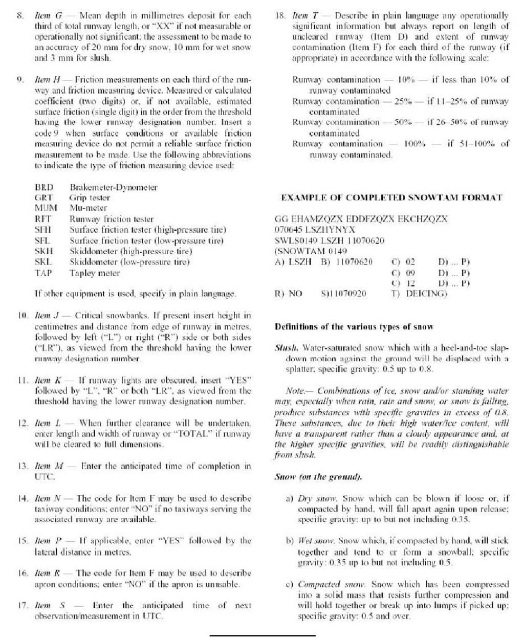
90 90
91 91

92 92
93 93
94 94
95 95
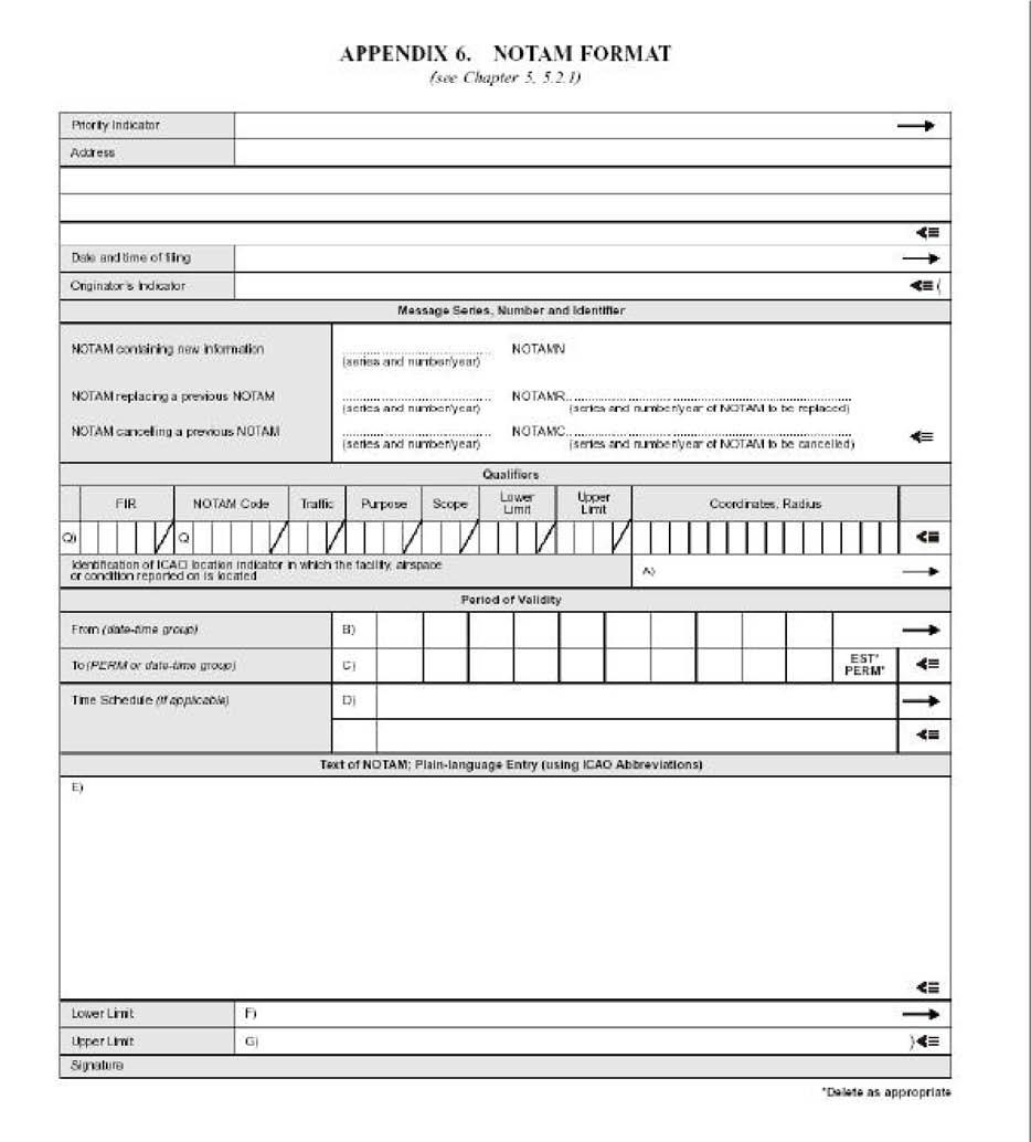
96 96
97 97
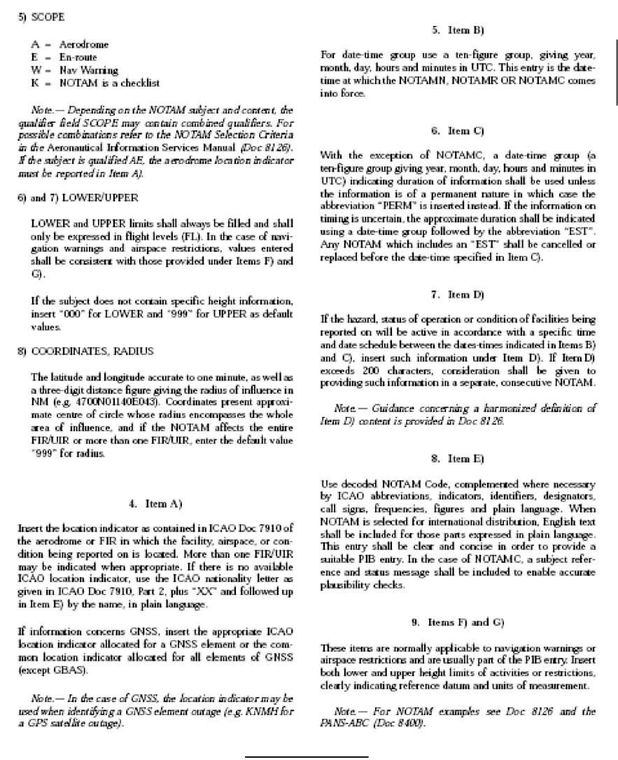
98 98
99 99
100 Rev. 3 dated 31 st October
101 Rev. 3 dated 31 st October
102 Rev. 3 dated 31 st October
 Rev. 3 dated 31 st October 2014 103")
103 Appendix 8 Terrain and Obstacle Data Requirements (See Para 10) Rev. 3 dated 31 st October

104 Rev. 3 dated 31 st October

105 Rev. 3 dated 31 st October
Overview ICAO Standards and Recommended Practices for Aerodrome Mapping Data reported to AIM
 Overview ICAO Standards and Recommended Practices for Aerodrome Mapping Data reported to AIM References ICAO SARPS Annex 14 Vol. I, 7 th Edition, July 2016 ICAO SARPS Annex 15, 15 th Edition, July 2016
GHANA CIVIL AVIATION (AIR NAVIGATION SERVICES) DIRECTIVES PART 15 AERONAUTICAL INFORMATION SERVICES
 DIRECTIVES PART 15 AERONAUTICAL INFORMATION SERVICES") GHANA CIVIL AVIATION (AIR NAVIGATION SERVICES) DIRECTIVES PART 15 AERONAUTICAL INFORMATION SERVICES TABLE OF CONTENTS TABLE OF CONTENTS... 2 15.1 GENERAL... 5 15.1.1 INTRODUCTION... 5 15.1.2 DEFINITIONS...
GHANA CIVIL AVIATION (AIR NAVIGATION SERVICES) DIRECTIVES PART 15 AERONAUTICAL INFORMATION SERVICES TABLE OF CONTENTS TABLE OF CONTENTS... 2 15.1 GENERAL... 5 15.1.1 INTRODUCTION... 5 15.1.2 DEFINITIONS...
Aeronautical Information Services
 GOVERNMENT OF INDIA OFFICE OF DIRECTOR GENERAL OF CIVIL AVIATION TECHNICAL CENTRE, OPP SAFDARJANG AIRPORT, NEW DELHI AIR SPACE AND AIR TRAFFIC MANAGEMENT SERIES 'I' PART I ISSUE II, EFFECTIVE: With effect
Subject: Aeronautical Information Services
 GOVERNMENT OF INDIA OFFICE OF DIRECTOR GENERAL OF CIVIL AVIATION TECHNICAL CENTRE, OPP SAFDARJANG AIRPORT, NEW DELHI CIVIL AVIATION REQUIREMENTS SECTION 4, AERODROME STANDARDS & AIR TRAFFIC SERVICES SERIES
AIS-AIMSG/12-SN/3 - Appendix A. New Annex 15. (Consolidated draft, 14 OCT 2015)
") AIS-AIMSG/12-SN/3 - Appendix A New Annex 15 (Consolidated draft, 14 OCT 2015) Contents CHAPTER 1. GENERAL 4 1.1 Definitions 4 1.2 Common reference systems for air navigation 10 1.2.1 Horizontal reference
AIS-AIMSG/12-SN/3 - Appendix A New Annex 15 (Consolidated draft, 14 OCT 2015) Contents CHAPTER 1. GENERAL 4 1.1 Definitions 4 1.2 Common reference systems for air navigation 10 1.2.1 Horizontal reference
Aeronautical Information Services
 Aeronautical Information Services Division Manual AIS-OPS Aeronautical Information Services Operations Manual (Draft) Published by Aeronautical Information Services Division First Edition January, 2010
AIS-AIMSG/12-SN/3-Appendix B PANS-AIM. (Consolidated draft, 14 OCT 2015)
") AIS-AIMSG/12-SN/3-Appendix B PANS-AIM (Consolidated draft, 14 OCT 2015) Contents CHAPTER 1 - GENERAL 9 1.1 Historical background 9 1.2 Scope and purpose 9 1.3 Status 10 1.4 Implementation 10 1.5 Publication
AIS-AIMSG/12-SN/3-Appendix B PANS-AIM (Consolidated draft, 14 OCT 2015) Contents CHAPTER 1 - GENERAL 9 1.1 Historical background 9 1.2 Scope and purpose 9 1.3 Status 10 1.4 Implementation 10 1.5 Publication
Aeronautical Information Services Issue 1 30 May 2012
 United Kingdom Overseas Territories Aviation Circular OTAC 175-1 Aeronautical Information Services Issue 1 30 May 2012 GENERAL Effective: on issue Overseas Territories Aviation Circulars are issued to
Proposals for Amendment to Annex 15 Aeronautical Information Services and PANS-AIM. Proposal for the creation of PANS-AIM
 International Civil Aviation Organization SAM/AIM/10-WP/13 South American Regional Office 10/08/17 Tenth Multilateral Meeting of the SAM Region for the transition from AIS to AIM (SAM/AIM/10) Lima, Peru,
Sao Tome and Principe Civil Aviation Régulations
 INAC INSTITUTO NACIONAL DE AVIAÇÃO CIVIL Sao Tome and Principe Civil Aviation Régulations STPCAR - PART 15 AERONAUTICAL INFORMATION SERVICES LIST OF EFFECTIVE PAGES Pages Revision Date of Revision 15-1
INTERNATIONAL STANDARDS AND RECOMMENDED PRACTICES
 Annex or Recommended Practice INTERNATIONAL STANDARDS AND RECOMMENDED PRACTICES CAR Part 1. CHAPTER 1. GENERAL N1.The object of the aeronautical information service (AIS) is to ensure the flow of aeronautical
CIVIL AVIATION REGULATIONS SURINAME PART 20 - AERONAUTICAL INFORMATION SERVICES VERSION 5.0
 CIVIL AVIATION REGULATIONS SURINAME PART 20 - AERONAUTICAL INFORMATION SERVICES VERSION 5.0 JANUARY 2018 AMENDMENTS Location Date Amended by Description / effective date CONTENTS 20. 1 PRELIMINARY PROVISIONS...
ADVISORY CIRCULAR AC-AD-005
 GHANA CIVIL AVIATION AUTHORITY ADVISORY CIRCULAR AC-AD-005 AERODROME QUALITY DATA SYSTEM GENERAL Ghana Civil Aviation Authority (GCAA) Advisory Circulars from Aerodrome Safety and Standards (ASAS) contain
TANZANIA CIVIL AVIATION AUTHORITY AIR NAVIGATION SERVICES INSPECTORATE. Title: CONSTRUCTION OF VISUAL AND INSTRUMENT FLIGHT PROCEDURES
 Page 1 of 8 1. PURPOSE 1.1. This Advisory Circular provides guidance to personnel involved in construction of instrument and visual flight procedures for publication in the Aeronautical Information Publication.
This document is meant purely as a documentation tool and the institutions do not assume any liability for its contents
 2010R0073 EN 20.10.2014 001.001 1 This document is meant purely as a documentation tool and the institutions do not assume any liability for its contents B COMMISSION REGULATION (EU) No 73/2010 of 26 January
COMMISSION REGULATION (EU)
") L 23/6 Official Journal of the European Union 27.1.2010 COMMISSION REGULATION (EU) No 73/2010 of 26 January 2010 laying down requirements on the quality of aeronautical data and aeronautical information
L 23/6 Official Journal of the European Union 27.1.2010 COMMISSION REGULATION (EU) No 73/2010 of 26 January 2010 laying down requirements on the quality of aeronautical data and aeronautical information
IRELAND SAFETY REGULATION DIVISION
 NOTICE TO AIR NAVIGATION SERVICE PROVIDERS IRELAND SAFETY REGULATION DIVISION NR S.016 ISSUE 1 DATE 03.03.10 IRISH AVIATION AUTHORITY AVIATION HOUSE HAWKINS STREET DUBLIN 2 Tel +353 1 6718655 Fax +353
CIVIL AVIATION REGULATIONS SURINAME PART 17 - AERONAUTICAL TELECOMMUNICATIONS VERSION 5.0
 CIVIL AVIATION REGULATIONS SURINAME PART 17 - AERONAUTICAL TELECOMMUNICATIONS VERSION 5.0 January 2018 AMENDMENTS Location Date Amended by Description CONTENTS 17.1 GENERAL... 4 17.1.1 Applicability...
DP-7 The need for QMS controlled processes in AIS/AIM. Presentation to QMS for AIS/MAP Service Implementation Workshop Dakar, Senegal, May 2011
 DP-7 The need for QMS controlled processes in AIS/AIM Presentation to QMS for AIS/MAP Service Implementation Workshop Dakar, Senegal, 17 19 May 2011 Werner Kurz Director International Relations Jeppesen
AERONAUTICAL INFORMATION DIGITAL DATBASES INTERGATION AND QUALITY MANAGED MIGRATION
 AIM SG/5 (Egypt, Cairo, 22 24 January 2019) AERONAUTICAL INFORMATION DIGITAL DATBASES INTERGATION AND QUALITY MANAGED MIGRATION Presentation contents : 1. NG Aviation company overview 2. New documentation
Aeronautical Information Services
 International Standards and Recommended Practices Annex 15 to the Convention on International Civil Aviation Aeronautical Information Services This edition incorporates all amendments adopted by the Council
Electronic Terrain and Obstacle Data
 International Civil Aviation Organization Electronic Terrain and Obstacle Data David Lewtas Chief, Aeronautical Information Unit (MET/AIM) 24 November 2010 ICAO CAR AIM Seminar Kingston, Jamaica 22-24
Agenda Item 2: Introduction to Doc Procedures for Air Navigation Services Aeronautical Information Management (PANS-AIM)
") IAIM WP/02 18/10/18 Integrated Aeronautical Information Management Transition Planning Meeting (IAIM) (AIM Strategy) Mexico City, Mexico, 29 to 31 October 2018 Agenda Item 2: Introduction to Doc 10066
IAIM WP/02 18/10/18 Integrated Aeronautical Information Management Transition Planning Meeting (IAIM) (AIM Strategy) Mexico City, Mexico, 29 to 31 October 2018 Agenda Item 2: Introduction to Doc 10066
CIVIL AVIATION REGULATIONS SURINAME PART 20 - AERONAUTICAL INFORMATION SERVICES VERSION 1.0
 CIVIL AVIATION REGULATIONS SURINAME PART 20 - AERONAUTICAL INFORMATION SERVICES VERSION 1.0 DECEMBER 2010 AMENDMENTS Location Date Amended by Description / effective date 20.10 1 Nov 2012 CASAS New Chapter
AERONAUTICAL INFORMATION SERVICES
 INTERNATIONAL STANDARDS AND RECOMMENDED PRACTICES AERONAUTICAL INFORMATION SERVICES ANNEX 15 TO THE CONVENTION ON INTERNATIONAL CIVIL AVIATION TENTH EDITION JULY 1997 This edition incorporates all amendments
Aeronautical Information Services
 International Standards and Recommended Practices Annex 15 to the Convention on International Civil Aviation Aeronautical Information Services This edition incorporates all amendments adopted by the Council
Data Origination, Management and WGS 84. ICAO PBN Seminar Data Origination & Management and WGS 84
 Data Origination, Management and WGS 84 1 Learning Objectives Overview Understand the implication of publishing incorrect navigational data in the State s AIP Identify why it is essential to use a common
GEN 3. SERVICES GEN AERONAUTICAL INFORMATION SERVICES
 GEN 3.1-1 1. RESPONSIBLE SERVICE GEN 3. SERVICES GEN 3.1 - AERONAUTICAL INFORMATION SERVICES 1.1 The object of the aeronautical information service (AIS) is to ensure the flow of aeronautical data and
30 SEP - 02 OCT, 2014
 EASTERN CARIBBEAN AERONAUTICAL INFORMATION MANAGEMENT (AIM) FAMILIARIZATION WORKSHOP TRINIDAD AND TOBAGO AVIATION AUTHORITY COMPLEX PORT OF SPAIN, TRINIDAD AND TOBAGO, 30 SEPTEMBER TO 2 OCTOBER 2014 30
AIS Basics - NOTAM, AIP, Amendments, Supplements, Circulars, Charts, and NOTAM Putting the basics in place
 AIS Basics - NOTAM, AIP, Amendments, Supplements, Circulars, Charts, and NOTAM Putting the basics in place Workshop for the development of AIS management and oversight for Civil Aviation Authorities CAA)
CAR ATS AIR TRAFFIC SERVICES
 CAR ATS AIR TRAFFIC SERVICES FOREWORD CONTENTS REVISION RECORD LIST of EFFECTIVE PAGES CAR ATS This Page Intentionally Left Blank CAR ATS FOREWORD 1. The Republic of San Marino Civil Aviation Authority,
Amendment 37,38 to Annex 15 Amendment 57 to Annex 4
 International Civil Aviation Organization Amendment 37,38 to Annex 15 Amendment 57 to Annex 4 Roberta Luccioli TO/AIM Seminario de la OACI sobre la Transicion al AIM Fases1 3 Outline 1. Amendment 37 to
CIVIL AVIATION REGULATIONS SURINAME PART 18 - AIR TRAFFIC SERVICES VERSION 5.0
 CIVIL AVIATION REGULATIONS SURINAME PART 18 - AIR TRAFFIC SERVICES VERSION 5.0 January 2018 Part 18 - Air Traffic Services AMENDMENTS Location Date Amended by Description Part 18 - Air Traffic Services
CIVIL AVIATION AUTHORITY, PAKISTAN OPERATIONAL CONTROL SYSTEMS CONTENTS
 CIVIL AVIATION AUTHORITY, PAKISTAN Air Navigation Order No. : 91-0004 Date : 7 th April, 2010 Issue : Two OPERATIONAL CONTROL SYSTEMS CONTENTS SECTIONS 1. Authority 2. Purpose 3. Scope 4. Operational Control
Related Rules This Advisory Circular relates specifically to CAR Part 175-Aeronautical Information Services Organisations Certification.
 Advisory Circular AC175-1 Aeronautical Information Service Organisations Certification Revision 2 23 September 2011 General Civil Aviation Authority Advisory Circulars contain information about standards,
Advisory Circular. File No.: Z U Issue No.: 01
 Advisory Circular Subject: Requirements for the Timely Notification of Amendments to Aeronautical Information Issuing Office: Standards AC No.: 300-015 File No.: Z 5000-34 U Issue No.: 01 RDIMS No.: 12611990v5
Official Journal of the European Union L 186/27
 7.7.2006 Official Journal of the European Union L 186/27 COMMISSION REGULATION (EC) No 1032/2006 of 6 July 2006 laying down requirements for automatic systems for the exchange of flight data for the purpose
CAR ATS AIR TRAFFIC SERVICES
 CAR ATS AIR TRAFFIC SERVICES FOREWORD CONTENTS REVISION RECORD LIST of EFFECTIVE PAGES CAR ATS This Page Intentionally Left Blank CAR ATS FOREWORD 1. The Republic of San Marino Civil Aviation Authority,
Excerpts from ICAO PBCS Manual
 IBAC Bulletin - 8 Dec. 2017 Attachment A Excerpts from ICAO PBCS Manual Chapter 4. Complying with and RCP/RSP specification 4-8 4.3.1.7 The ANSP should establish the following, subject to a bilateral,
INTERNATIONAL STANDARDS AND RECOMMENDED PRACTICES AERONAUTICAL CHARTS ANNEX 4 TO THE CONVENTION ON INTERNATIONAL CIVIL AVIATION
 COVER SHEET TO AMENDMENT 57 INTERNATIONAL STANDARDS AND RECOMMENDED PRACTICES AERONAUTICAL CHARTS ANNEX 4 TO THE CONVENTION ON INTERNATIONAL CIVIL AVIATION ELEVENTH EDITION JULY 2009 INTERNATIONAL CIVIL
International Civil Aviation Organization
 International Civil Aviation Organization WP22 BIS Agenda Item 11: Adoption of Amendment 36 to ICAO Annex 15 and Amendment 56 to Annex 4 and its implications to the AFI Region as per the AIS-AIM Transition
Quality Management System (QMS)
") Quality Management System (QMS) Abbas NIKNEJAD Regional Officer, AIM/ATM Annex 15 provisions related to QMS Quality: Degree to which a set of inherent characteristics fulfils requirements (ISO 9000*).
Quality Management System (QMS) Abbas NIKNEJAD Regional Officer, AIM/ATM Annex 15 provisions related to QMS Quality: Degree to which a set of inherent characteristics fulfils requirements (ISO 9000*).
Consideration will be given to other methods of compliance which may be presented to the Authority.
 Advisory Circular AC 139-10 Revision 1 Control of Obstacles 27 April 2007 General Civil Aviation Authority advisory circulars (AC) contain information about standards, practices and procedures that the
Quality Assurance. Introduction Need for quality assurance Answer to the need of quality assurance Details on quality assurance Conclusion A B C D E
 Quality Assurance 1 A B C D E Introduction Need for quality assurance Answer to the need of quality assurance Details on quality assurance Conclusion 2 1 Introduction 3 Introduction The implementation
Sample Regulations for Water Aerodromes
 Sample Regulations for Water Aerodromes First Edition (unedited version) March 2015 Notice to users: This document is an unedited version which is made available to the public for convenience. Its content
Guidelines for Workflow of AIP AMDT, AIP SUP & AIRAC at Iraq CAA AIS HQ
 Guidelines for Workflow of AIP AMDT, AIP SUP & AIRAC at Iraq CAA AIS HQ July 23rd, 2011 INDEX 1- INTRODUCTION... 2 2- COMPILING AND EDITING OF AN AIP... 3 2.1- Language... 3 2.2- Page Numbering... 3 3-
COMMISSION IMPLEMENTING REGULATION (EU)
") 18.10.2011 Official Journal of the European Union L 271/15 COMMISSION IMPLEMENTING REGULATION (EU) No 1034/2011 of 17 October 2011 on safety oversight in air traffic management and air navigation services
18.10.2011 Official Journal of the European Union L 271/15 COMMISSION IMPLEMENTING REGULATION (EU) No 1034/2011 of 17 October 2011 on safety oversight in air traffic management and air navigation services
FLIGHT OPERATIONS PANEL (FLTOPSP)
") International Civil Aviation Organization FLTOPSP/1-WP/3 7/10/14 WORKING PAPER FLIGHT OPERATIONS PANEL (FLTOPSP) FIRST MEETING Montréal, 27 to 31 October 2014 Agenda Item 4: Active work programme items
International Civil Aviation Organization FLTOPSP/1-WP/3 7/10/14 WORKING PAPER FLIGHT OPERATIONS PANEL (FLTOPSP) FIRST MEETING Montréal, 27 to 31 October 2014 Agenda Item 4: Active work programme items
ADQ Regulators Working Group
 ADQ Regulators Working Group Common Understanding 01/2013 Application of the provisions of Commission Regulation (EU) 73/2010 to NOTAM Edition: 1.4 Date: 20 October 2016 Reference: ARWG CU 01/2013 ARWG
COMMISSION OF THE EUROPEAN COMMUNITIES. Draft. COMMISSION REGULATION (EU) No /2010
 No /2010") COMMISSION OF THE EUROPEAN COMMUNITIES Brussels, XXX Draft COMMISSION REGULATION (EU) No /2010 of [ ] on safety oversight in air traffic management and air navigation services (Text with EEA relevance)
COMMISSION OF THE EUROPEAN COMMUNITIES Brussels, XXX Draft COMMISSION REGULATION (EU) No /2010 of [ ] on safety oversight in air traffic management and air navigation services (Text with EEA relevance)
REGULATION No. 10/2011 ON APPROVAL OF FLIGHT PROCEDURES INCLUDING SID-s AND STAR-s. Article 1 Scope of Application
 Republika e Kosovës Republika Kosovo Republic of Kosovo Autoriteti i Aviacionit Civil i Kosovës Autoritet Civilnog Vazduhoplovstva Kosova Civil Aviation Authority of Kosovo Director General of Civil Aviation
Air Traffic Services.
 GOVERNMENT OF INDIA OFFICE OF DIRECTOR GENERAL OF CIVIL AVIATION TECHNICAL CENTRE, OPP SAFDARJANG AIRPORT, NEW DELHI CIVIL AVIATION REQUIREMENTS SECTION 9 AIR SPACE AND AIR TRAFFIC MANAGEMENT SERIES 'E',
THE CIVIL AVIATION ACT (CAP. 80) THE CIVIL AVIATION (AERONAUTICAL CHARTS) REGULATIONS, 2017 PART I PRELIMINARY PROVISIONS
 THE CIVIL AVIATION (AERONAUTICAL CHARTS) REGULATIONS, 2017 PART I PRELIMINARY PROVISIONS") GOVERNMENT NOTICE NO. 70 published on 24/02/2017 THE CIVIL AVIATION ACT (CAP. 80) THE CIVIL AVIATION (AERONAUTICAL CHARTS) REGULATIONS, 2017 1. Citation 2. Interpretation 3. Application 4. Availability
GOVERNMENT NOTICE NO. 70 published on 24/02/2017 THE CIVIL AVIATION ACT (CAP. 80) THE CIVIL AVIATION (AERONAUTICAL CHARTS) REGULATIONS, 2017 1. Citation 2. Interpretation 3. Application 4. Availability
Introduction to Amendment 40 to Annex 15
 Introduction to Amendment 40 to Annex 15 Roberta Luccioli ICAO AIM Technical Officer Interregional EUR/MID PANS AIM Workshop (Paris, 10-12 July 2018) Outline From Aeronautical information services (AIS)
L 342/20 Official Journal of the European Union
 L 342/20 Official Journal of the European Union 24.12.2005 COMMISSION REGULATION (EC) No 2150/2005 of 23 December 2005 laying down common rules for the flexible use of airspace (Text with EEA relevance)
AIM WG: Contributing to ATM Success. Roland Baumann Head Planning & Development AIM skyguide
 AIM WG: Contributing to ATM Success Roland Baumann Head Planning & Development AIM skyguide AIM Contributing to ATM Success change of the value proposition towards ATM Information Management Services the
Manual of Radiotelephony
 Doc 9432 AN/925 Manual of Radiotelephony Approved by the Secretary General and published under his authority Fourth Edition - 2007 International Civil Aviation Organization AMENDMENTS The issue of amendments
COMMISSION REGULATION (EU) No 255/2010 of 25 March 2010 laying down common rules on air traffic flow management
 No 255/2010 of 25 March 2010 laying down common rules on air traffic flow management") L 80/10 Official Journal of the European Union 26.3.2010 COMMISSION REGULATION (EU) No 255/2010 of 25 March 2010 laying down common rules on air traffic flow management (Text with EEA relevance) THE EUROPEAN
L 80/10 Official Journal of the European Union 26.3.2010 COMMISSION REGULATION (EU) No 255/2010 of 25 March 2010 laying down common rules on air traffic flow management (Text with EEA relevance) THE EUROPEAN
RECOMMENDED GUIDANCE FOR FPL AND RELATED ATS MESSAGES
 RECOMMENDED GUIDANCE FOR FPL AND RELATED ATS MESSAGES Abbreviations ACI ADS ADS-B ADS-C AFTN AIDC AIP ANSP AMHS APAC APANPIRG ASBU ASIOACG ATFM ATM ATS AUSEP CHG CNL CPDLC CPL DARP DLA EOBT FAA FIR FIRBX
AERONAUTICAL SERVICES ADVISORY MEMORANDUM (ASAM) Focal Point: Gen
 Focal Point: Gen") Page 1 of 6 1 INTRODUCTION Each route shall be assigned a designator that is unique for that aerodrome. The designator shall be defined in accordance with Annex 11, Appendix 3. In addition, the first 4
Page 1 of 6 1 INTRODUCTION Each route shall be assigned a designator that is unique for that aerodrome. The designator shall be defined in accordance with Annex 11, Appendix 3. In addition, the first 4
OVERSEAS TERRITORIES AVIATION REQUIREMENTS (OTARs)
") OVERSEAS TERRITORIES AVIATION REQUIREMENTS (OTARs) Part 171 AERONAUTICAL TELECOMMUNICATION SERVICES Published by Air Safety Support International Ltd Air Safety Support International Limited 2005 First
OVERSEAS TERRITORIES AVIATION REQUIREMENTS (OTARs) Part 171 AERONAUTICAL TELECOMMUNICATION SERVICES Published by Air Safety Support International Ltd Air Safety Support International Limited 2005 First
GOVERNMENT OF INDIA OFFICE OF THE DIRECTOR GENERAL OF CIVIL AVIATION TECHNICAL CENTRE, OPP. SAFDARJUNG AIRPORT, NEW DELHI
 GOVERNMENT OF INDIA OFFICE OF THE DIRECTOR GENERAL OF CIVIL AVIATION TECHNICAL CENTRE, OPP. SAFDARJUNG AIRPORT, NEW DELHI - 110003 CIVIL AVIATION REQUIREMENT SECTION 8 - AIRCRAFT OPERATIONS SERIES 'S',
EUROPEAN COMMISSION DIRECTORATE-GENERAL FOR MOBILITY AND TRANSPORT
 EUROPEAN COMMISSION DIRECTORATE-GENERAL FOR MOBILITY AND TRANSPORT DIRECTORATE E - Air Transport E.2 - Single sky & modernisation of air traffic control Brussels, 6 April 2011 MOVE E2/EMM D(2011) 1. TITLE
Guidelines for NOTAM Workflow and Allocation of Responsibilities
 Guidelines for NOTAM Workflow and Allocation of Responsibilities May 19 2011 INDEX 1- MAIN OBJECTIVES 1 2- ORIGINATION OF NOTAM 1 3- VALUE OF A NOTAM 3 4- DURATION OF NOTAM 4 5- THE AERONAUTICAL DATA CHAIN
AERODROME LICENCE APPLICATION PROCESS
 0000180111 Page 2 Why is a Licence Required? An aerodrome licence is required for a site if it is intended to facilitate operations by commercial transport aircraft, other aerial work other than rotorcraft,
AIP KUWAIT FIR AMENDMENT 28 IMPLEMENTATION AIRAC DATE 25 NOVEMBER 2004
 Phone: +965 476 25 31 FAX: +965 476 55 12 AFTN: OKNOYNYX Email :ais1@kuwait-airport.com.kw www.kuwait-airport.com.kw STATE OF DIRECTORATE GENERAL OF CIVIL AVIATION AERONAUTICAL INFORMATION SERVICE (AIS)
Performance Based Communication and Surveillance in the ICAO North Atlantic Region. PBCS in NAT HLA
 Federal Departement of the Environment, Transport, Energy and Communications DETEC Federal Office of Civil Aviation FOCA Safety Division - Flight Operations FOCA GM/INFO Guidance Material / Information
AD 2. AERODROMES. For the ICAO location indicators used for Canadian aerodromes, refer to the following publications:
 AIP CANADA (ICAO) PART 3 AERODROMES (AD) AD 2. AERODROMES AD 2.1 Aerodrome Location Indicator and Name For the ICAO location indicators used for Canadian aerodromes, refer to the following publications:
to The Uganda Gazette No. 35 Volume CVII dated 10th June, 2014 Printed by UPPC, Entebbe, by Order of the Government No. 63.
 STATUTORY INSTRUMENTS SUPPLEMENT No. 18 10th June, 2014 STATUTORY INSTRUMENTS SUPPLEMENT to The Uganda Gazette No. 35 Volume CVII dated 10th June, 2014 Printed by UPPC, Entebbe, by Order of the Government.
SUMMARY REPORT ON THE SAFETY OVERSIGHT AUDIT FOLLOW-UP OF THE DIRECTORATE GENERAL OF CIVIL AVIATION OF KUWAIT
 ICAO Universal Safety Oversight Audit Programme SUMMARY REPORT ON THE SAFETY OVERSIGHT AUDIT FOLLOW-UP OF THE DIRECTORATE GENERAL OF CIVIL AVIATION OF KUWAIT (Kuwait, 17 to 20 September 2003) International
Part 175.D & E Aeronautical Data Originators Data Product Specification: Vertical Obstructions
 Part 175.D & E Aeronautical Data Originators Data Product Specification: Vertical Obstructions ATS-DPS-0010 Version 2 Effective 22 December 2017 Prepared: Authorised: Sateesh Sathineni Aeronautical Data
AIS-AIM Study Group Working Status
 International Civil Aviation Organization AIS-AIM Study Group Working Status Roberta Luccioli TO/AIM Seminario de la OACI sobre la Transicion al AIM Fases1 3 Outline Development and Implementation of AIS
TWELFTH AIR NAVIGATION CONFERENCE
 International Civil Aviation Organization 14/5/12 WORKING PAPER TWELFTH AIR NAVIGATION CONFERENCE Montréal, 19 to 30 November 2012 Agenda Item 4: Optimum Capacity and Efficiency through global collaborative
OPERATIONS CIRCULAR. Subject: Performance Based Communication and Surveillance (PBCS) OC NO 01 of 2018 Date: 23 rd March 2018
 OC NO 01 of 2018 Date: 23 rd March 2018") GOVERNMENT OF INDIA CIVIL AVIATION DEPARTMENT DIRECTOR GENERAL OF CIVIL AVIATION OC NO 01 of 2018 Date: 23 rd March 2018 OPERATIONS CIRCULAR File No AV 22024/02/2018-FS Subject: Performance Based Communication
GOVERNMENT OF INDIA CIVIL AVIATION DEPARTMENT DIRECTOR GENERAL OF CIVIL AVIATION OC NO 01 of 2018 Date: 23 rd March 2018 OPERATIONS CIRCULAR File No AV 22024/02/2018-FS Subject: Performance Based Communication
Introduction to the Data Catalogue
 AIS-AIMSG/11-SN /11 22/04/15 AERONAUTICAL INFORMATION SERVICES-AERONAUTICAL INFORMATION MANAGEMENT STUDY GROUP (AIS-AIMSG) ELEVENTH MEETING Montreal, 27 April to 1 May 2015 Agenda Item 2: AIM Domain Scope
AERONAUTICAL SERVICES ADVISORY MEMORANDUM (ASAM) Focal Point: Gen
 Focal Point: Gen") Page 1 of 14 1 INTRODUCTION This guidance material has been prepared for use for the definition of protected surfaces in the vicinity of aerodromes. Survey information for an aerodrome is essential for
Page 1 of 14 1 INTRODUCTION This guidance material has been prepared for use for the definition of protected surfaces in the vicinity of aerodromes. Survey information for an aerodrome is essential for
Part 175. Aeronautical Information Service Organisations Certification. CAA Consolidation. 10 March 2017
 Part 175 CAA Consolidation 10 March 2017 Aeronautical Information Service Organisations Certification Published by the Civil Aviation Authority of New Zealand DESCRIPTION Part 175 prescribes rules governing
SESAR Active ECAC INF07 REG ASP MIL APO USE INT IND NM
 SESAR Active ECAC INF07 REG ASP MIL APO USE INT IND NM Subject matter and scope * The extension of the applicability area to non-eu ECAC States that have not signed an aviation agreement with EU, as well
AFI Plan Aerodromes Certification Project Workshop for ESAF Region (Nairobi, Kenya, August 2016)
") AFI Plan Aerodromes Certification Project Workshop for ESAF Region (Nairobi, Kenya, 23-26 August 2016) Aerodromes Certification- ICAO Requirements Arthemon Ndikumana RO/AGA, Nairobi 08/09/2016 AFI Plan
AFI Plan Aerodromes Certification Project Workshop for ESAF Region (Nairobi, Kenya, 23-26 August 2016) Aerodromes Certification- ICAO Requirements Arthemon Ndikumana RO/AGA, Nairobi 08/09/2016 AFI Plan
USE OF RADAR IN THE APPROACH CONTROL SERVICE
 USE OF RADAR IN THE APPROACH CONTROL SERVICE 1. Introduction The indications presented on the ATS surveillance system named radar may be used to perform the aerodrome, approach and en-route control service:
Part 171. Aeronautical Telecommunication Services - Operation and Certification. CAA Consolidation. 10 March 2017
 Part 171 CAA Consolidation 10 March 2017 Aeronautical Telecommunication Services - Operation and Certification Published by the Civil Aviation Authority of New Zealand DESCRIPTION Part 171 provides the
European Aviation Safety Agency
 European Aviation Safety Agency RMG.0464 Requirements for air traffic services ICAO ANNEX 11 CHECKLIST based on ICAO ANNEX 11 Thirteenth Edition July 2001 incorporating all amendments up to Amendment No
Curriculum for AIM Training Module 2: ARO Officer
 Curriculum for AIM Training Module 2: ARO Officer 1. THE AERONAUTICAL INFORMATION SERVICES The general objectives are to enable students to: Appreciate how the aeronautical information services function;
Safety and Airspace Regulation Group. 31 May Policy Statement STANDARD INSTRUMENT DEPARTURE TRUNCATION POLICY.
 Safety and Airspace Regulation Group 31 May 2018 Policy Statement STANDARD INSTRUMENT DEPARTURE TRUNCATION POLICY 1 Introduction 1.1 This Policy Statement (PS) presents CAA policy and guidance to Air Navigation
Learning Objectives. By the end of this presentation you should understand:
 Designing Routes 1 Learning Objectives By the end of this presentation you should understand: Benefits of RNAV Considerations when designing airspace routes The basic principles behind route spacing The
ICAO Aerodrome s Manual. AERODROME S INSPECTOR WORKSHOP St. Maarten, MAHO June 2012
 ICAO Aerodrome s Manual AERODROME S INSPECTOR WORKSHOP St. Maarten, MAHO 11-15 June 2012 Objectives - Identify the requirements listed in Annex 14 regarding the development and maintenance of an aerodrome
Civil Aviation Requirements For Aeronautical Charts
 Civil Aviation Requirements For Aeronautical Charts CAR 4 AERONAUTICAL CHARTS First Edition January, 2009 Civil Aviation Authority of Nepal Amendments Amendments and Corrigenda to these " CIVIL AVIATION
4.1 This document outlines when a proposal for a SID Truncation may be submitted and details the submission requirements.
 Safety and Airspace Regulation Group 13 May 2014 Policy Statement STANDARD INSTRUMENT DEPARTURE TRUNCATION POLICY 1 Introduction 1.1 This Policy Statement (PS) is intended to provide guidance to ANSPs
ICAO GANP Requirements and Evolution
 ICAO GANP Requirements and Evolution Olga de Frutos Brussels/October 2017 Flight Plan Context Current GANP Role in ICAO Next edition: AMET, DATM, FICE and SWIM The future ATM system To achieve an interoperable
Contents. Subpart A General 91.1 Purpose... 7
 Contents Rule objective... 3 Extent of consultation... 3 Summary of comments... 4 Examination of comments... 6 Insertion of Amendments... 6 Effective date of rule... 6 Availability of rules... 6 Part 91
GOVERNMENT OF INDIA OFFICE OF DIRECTOR GENERAL OF CIVIL AVIATION
 GOVERNMENT OF INDIA OFFICE OF DIRECTOR GENERAL OF CIVIL AVIATION ANSS AC NO. 1 of 2017 31.07. 2017 Air Space and Air Navigation Services Standard ADVISORY CIRCULAR Subject: Procedures to follow in case
PBN Syllabus Aeroplane. Learning Objective. phase Theoretical PBN concept. in ICAO Doc 9613)
") PBN Syllabus Aeroplane Training Topic phase Theoretical PBN concept training (as described in ICAO Doc 9613) PBN principles PBN components PBN scope Navigation specifications RNAV and RNP Navigation functional
PBN Syllabus Aeroplane Training Topic phase Theoretical PBN concept training (as described in ICAO Doc 9613) PBN principles PBN components PBN scope Navigation specifications RNAV and RNP Navigation functional
THE REPUBLIC OF THE UNION OF MYANMAR MINISTRY OF TRANSPORT AND COMMUNICATIONS DEPARTMENT OF CIVIL AVIATION MYANMAR CIVIL AVIATION REQUIREMENTS
 THE REPUBLIC OF THE UNION OF MYANMAR MINISTRY OF TRANSPORT AND COMMUNICATIONS DEPARTMENT OF CIVIL AVIATION MYANMAR CIVIL AVIATION REQUIREMENTS Part 5 : Air Navigation Services Section 2 Air Traffic Services
Any queries about the content of the attached document should be addressed to: ICAO EUR/NAT Office:
 Serial Number: 2018_005 Subject: Special Procedures For In-Flight Contingencies in Oceanic Airspace Originator: NAT SPG Issued: 17 DEC 2018 Effective:28 MAR 2019 The purpose of this North Atlantic Operations
Subject: Automatic Dependent Surveillance-Broadcast (ADS-B) Operations and Operational Authorization
 Operations and Operational Authorization") OC NO 17 OF 2014 Date: 14 th October 2014 File No AV 22024/30/2014-FSD GOVERNMENT OF INDIA CIVIL AVIATION DEPARTMENT DIRECTOR GENERAL OF CIVIL AVIATION OPERATIONS CIRCULAR Subject: Automatic Dependent
OC NO 17 OF 2014 Date: 14 th October 2014 File No AV 22024/30/2014-FSD GOVERNMENT OF INDIA CIVIL AVIATION DEPARTMENT DIRECTOR GENERAL OF CIVIL AVIATION OPERATIONS CIRCULAR Subject: Automatic Dependent
TWELFTH AIR NAVIGATION CONFERENCE
 International Civil Aviation Organization AN-Conf/12-WP/8 7/5/12 WORKING PAPER TWELFTH AIR NAVIGATION CONFERENCE Montréal, 19 to 30 November 2012 Agenda Item 3: Interoperability and data through globally
WORKING TOGETHER TO ENHANCE AIRPORT OPERATIONAL SAFETY. Ermenando Silva APEX, in Safety Manager ACI, World
 WORKING TOGETHER TO ENHANCE AIRPORT OPERATIONAL SAFETY Ermenando Silva APEX, in Safety Manager ACI, World Aerodrome Manual The aim and objectives of the aerodrome manual and how it is to be used by operating
PBN Syllabus Helicopter. Learning Objective. phase Theoretical PBN concept. in ICAO Doc 9613)
") PBN Syllabus Helicopter Training Topic phase Theoretical PBN concept training (as described in ICAO Doc 9613) PBN principles PBN components PBN scope Navigation specifications RNAV and RNP Navigation functional
PBN Syllabus Helicopter Training Topic phase Theoretical PBN concept training (as described in ICAO Doc 9613) PBN principles PBN components PBN scope Navigation specifications RNAV and RNP Navigation functional
Contents. Section No. Subject. Subpart- A General Applicability
 Contents Section No. Subject 175.1 Applicability Subpart- A General 175.3 Requirement for Certificate 175.5 Application for Certificate 175.7 Issue of Certificate 175.9 Privileges of Certificate 175.11
Competency of Surveyors
 Competency of Surveyors Session 2.1: Obstacle Identification & Data Collection 5 December 2017 AERODROME SAFEGUARDING WORKSHOP (Cairo, Egypt, 4-6 December 2017) Presented by: Michelle Soliman, Aerodrome