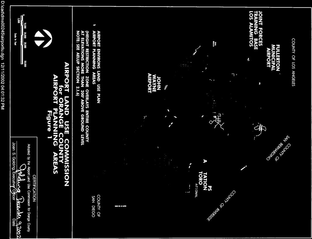
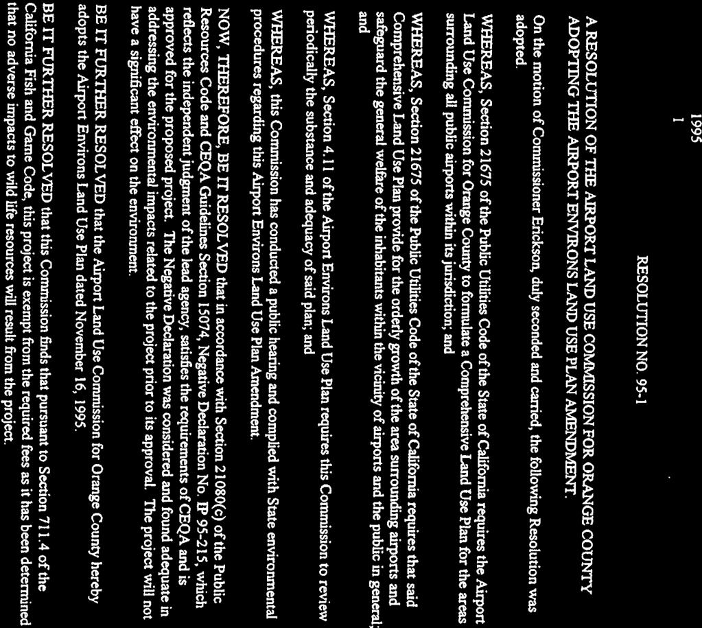
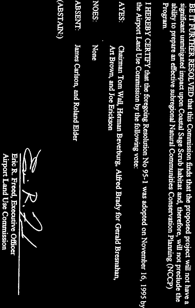
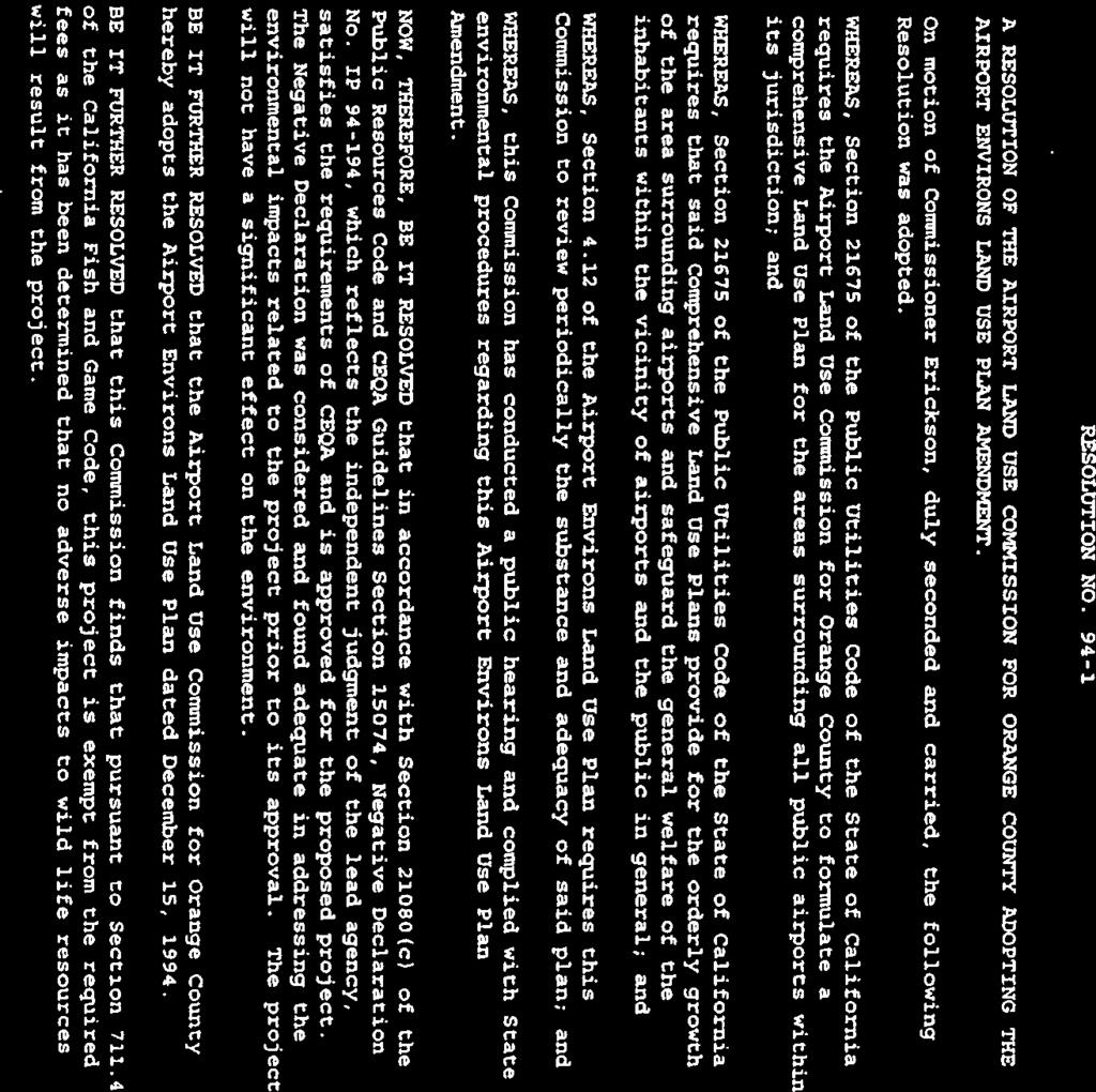
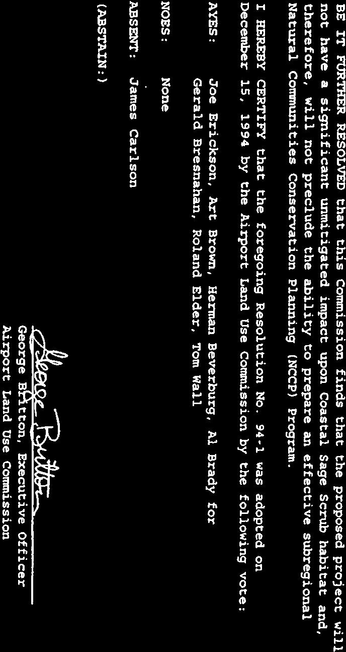
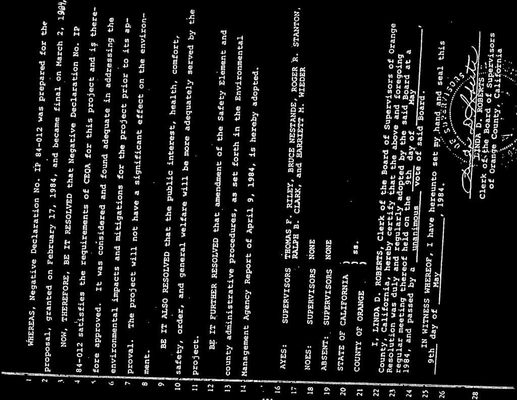
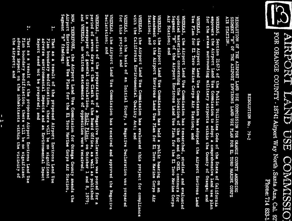
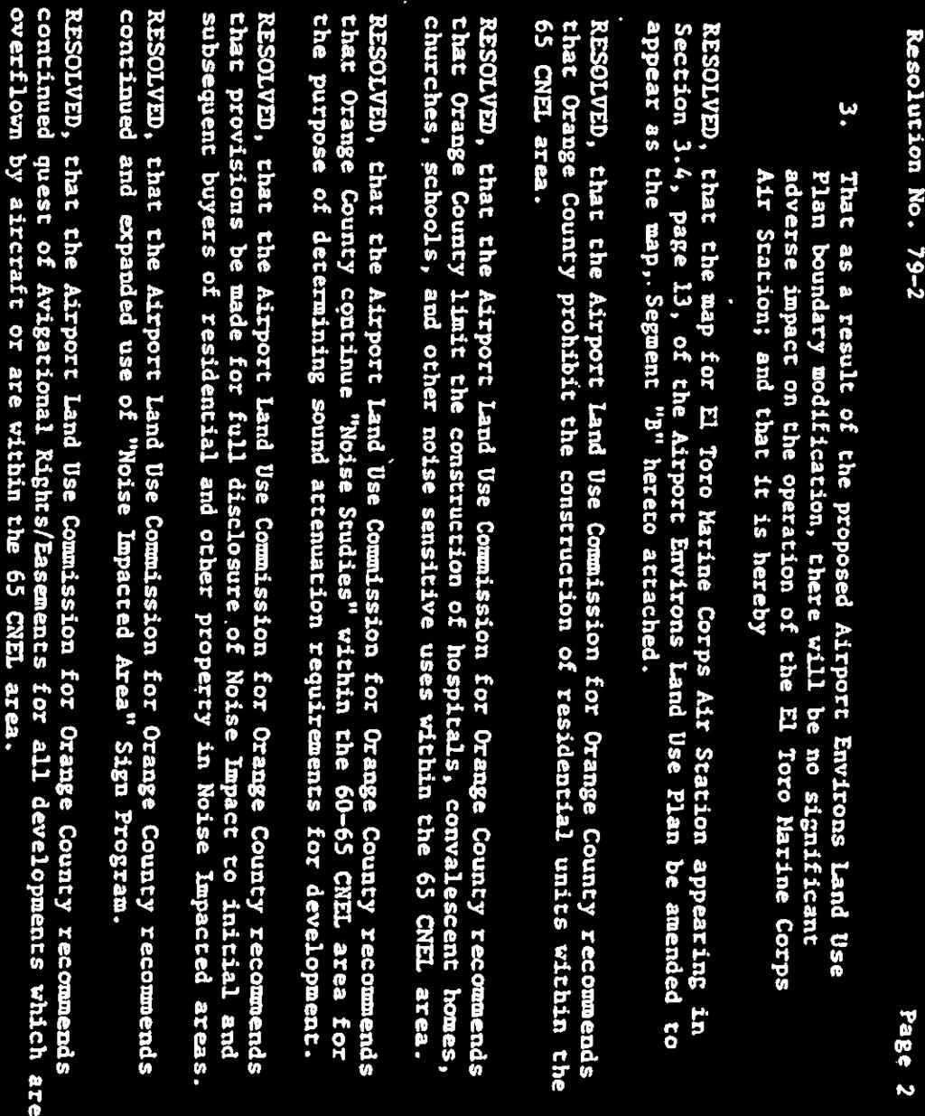
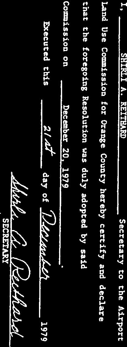
Airport Land Use Commission. AIRPORT ENVIRONS LAND USE PLAN for FULLERTON MUNICIPAL AIRPORT
|
|
|
- Garey Thompson
- 6 years ago
- Views:
Transcription
1 Airport Land Use Commission AIRPORT ENVIRONS LAND USE PLAN for FULLERTON MUNICIPAL AIRPORT Amended: November 18, 2004
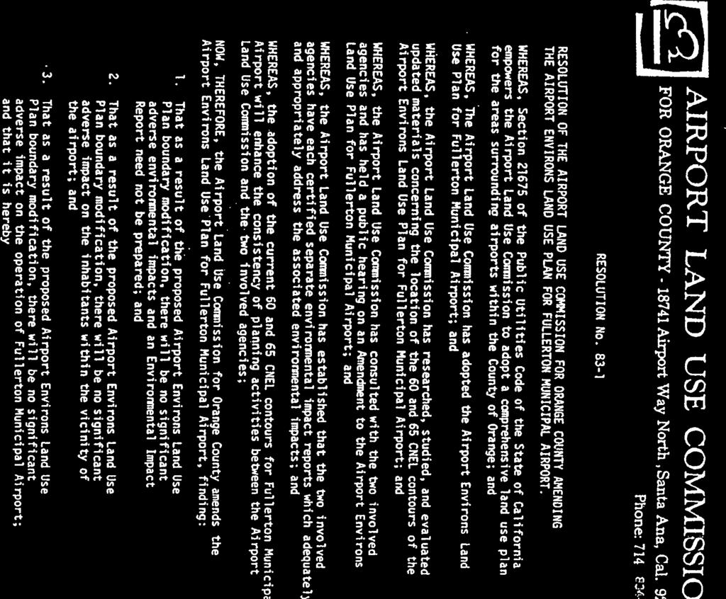
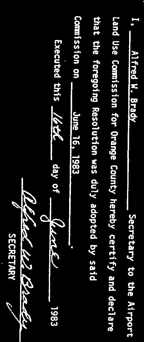
2 AIRPORT ENVIRONS LAND USE PLAN November 18, 2004 Text of Plan Adopted April 17, 1975 Fullerton Municipal Airport Adopted June 5, 1975 First Revised Edition Adopted June 30, 1983 Updated for Amendments Adopted Thru December 19, 1985 Second Revised Edition Adopted September 15, Airport Environs Land Use Plan Amendment Adopted November 29, Airport Environs Land Use Plan Amendment Adopted December 15, Airport Environs Land Use Plan Amendment Adopted November 16, Airport Environs Land Use Plan Amendment Adopted December 19, Airport Environs Land Use Plan Amendment Adopted November 18, 2004 AIRPORT LAND USE COMMISSION FOR ORANGE COUNTY MEMBERSHIP AS OF NOVEMBER 2004 Commissioners Gerald Bresnahan, Chairman Rod Propst, Vice-Chairman Herman F. Beverburg Harry Dotson Tom O Malley Melody Carruth Don Webb Alternates Patricia Campbell Winnie Houston Stephen Beverburg Patricia Campbell Leonard Kranser L. David Markley Homer Bludau Staff Kari A. Rigoni, Executive Officer Alfred Brady and Sue Tanner
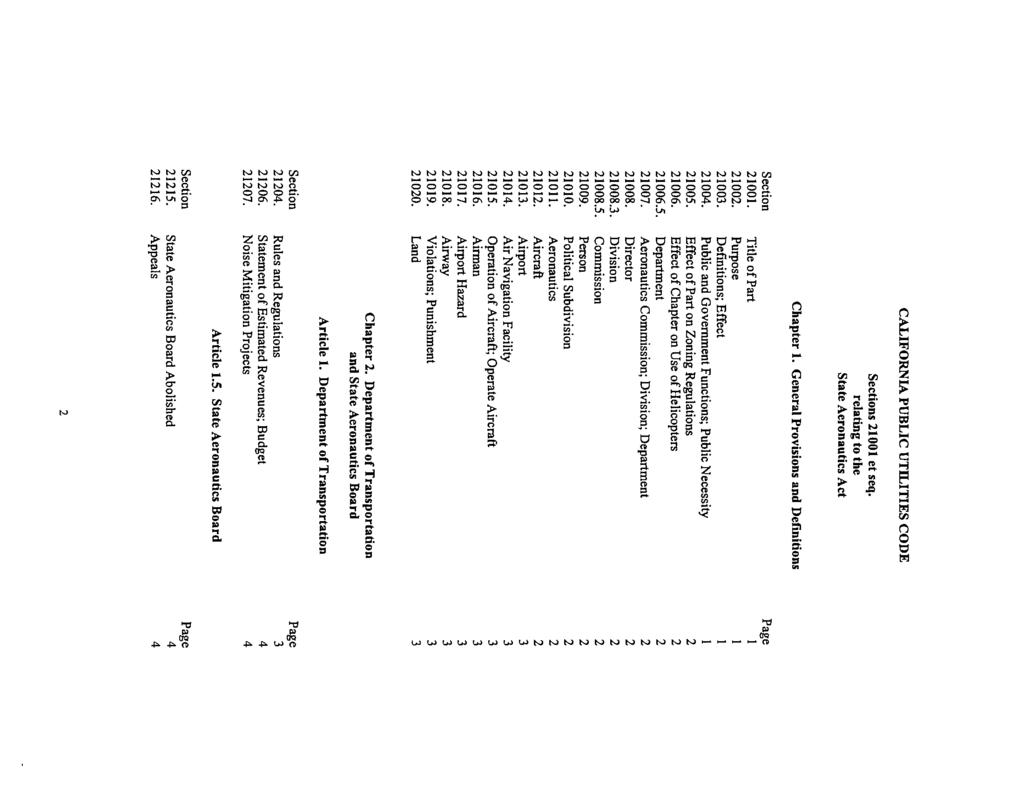
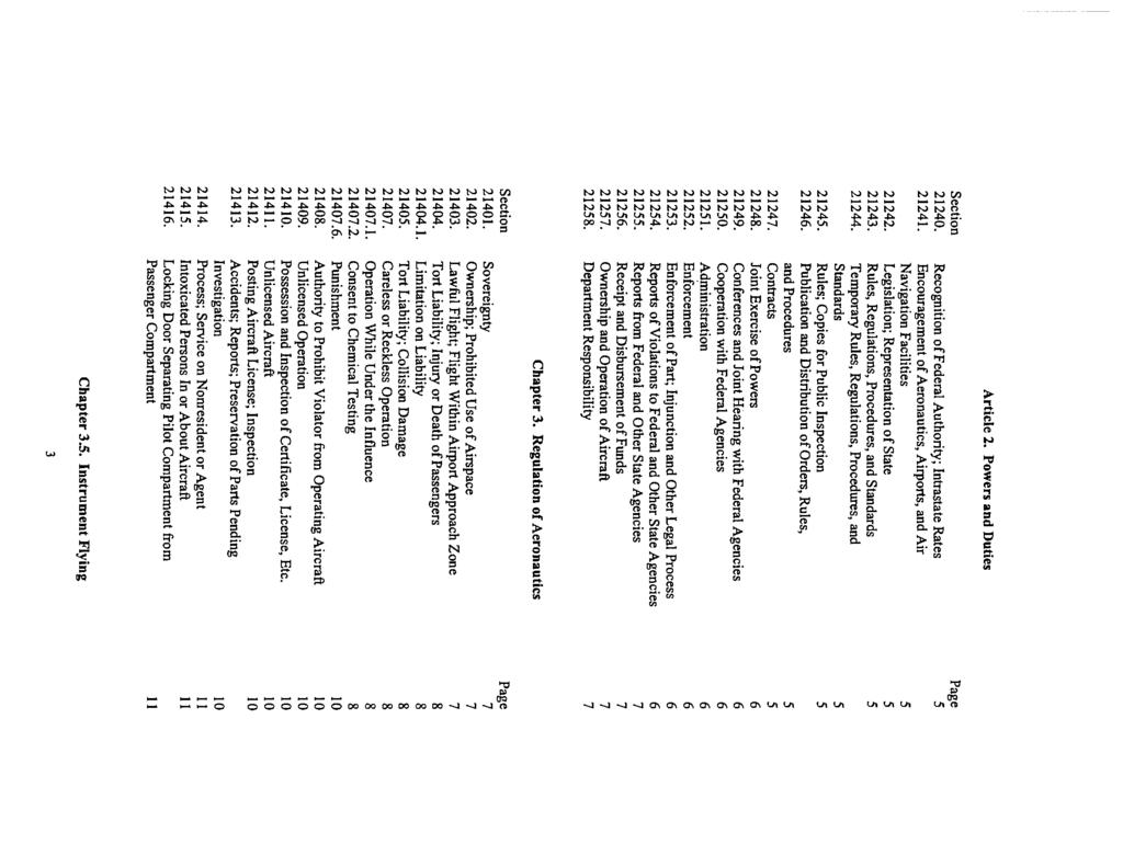
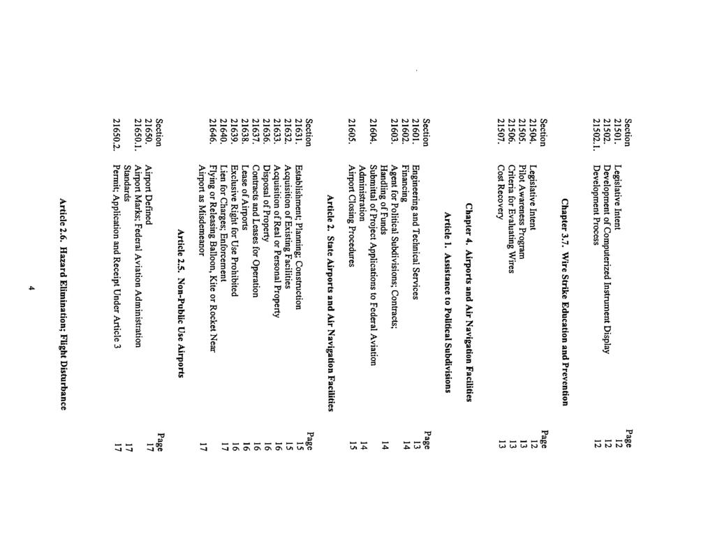
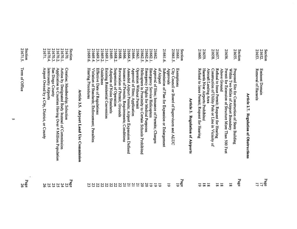
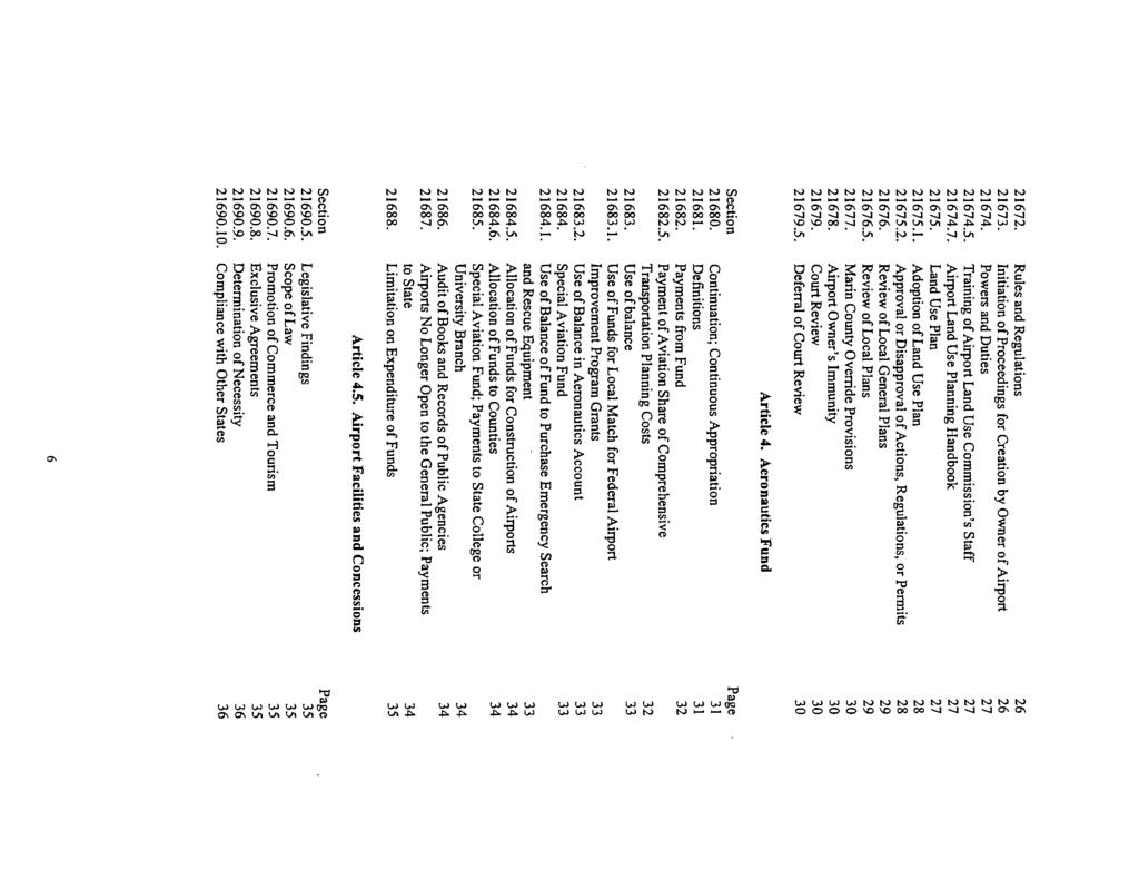
3 TABLE OF CONTENTS Page SECTION INTRODUCTION Background Purpose and Scope Authority Requirements Concept of the Planning Document Applicability Glossary/Definitions 6 SECTION PLANNING GUIDELINES Standards and Criteria Aircraft Noise Accident Potential Zones (Civilian Airports) Building Height Restrictions Air Transportation Airports/Heliports/Helistops Planning Areas - Airports Planning Areas - New Airports Establishment of Planning Areas Fullerton Municipal Airport 17 SECTION LAND USE POLICIES Concept Land Use Policies General Policy Specific Policies Noise Impact Zone "1" - High Noise Impact Noise Impact Zone "2" - Moderate Noise Impact Land Use Runway Protection Zone "RPZ", Extreme Crash Hazard 24 - i -
4 3.2.6 Accident Potential Zone I "APZ I", Considerable Crash Hazard Accident Potential Zone II "APZ II", Limited Crash Hazard Height Restriction Zone Airspace/Airport Inconsistency Avigation Easements Specific Policies for Consistency Determinatation 26 SECTION IMPLEMENTATION Statutes General Plans and Specific Plans (Zoning) Amendments to General Plans and Specific Plans (Zoning) Zoning Ordinances and Building Regulations Airport Master Plans Other Submittals Submittal Requirements Acceptance of Submittal Who May File Commission Finding of Inconsistency Inconsistent Local Agency Continuous Monitoring Periodic Review AELUP Amendments 32 - ii -
5 APPENDICES Appendix A Appendix B Appendix C Appendix D Appendix E Appendix F Appendix G Appendix H Appendix I Appendix J State Aeronautics Act and Airport Land Use Commission Law Summary of Federal Aviation Regulations Part 77 - Objects Affecting Navigable Airspace Pertinent Resolutions of the Airport Land Use Commission Impact Zones Map, Height Restriction Zone Map, Imaginary Surfaces Map Place Holder for Accident History Maps Summary of Federal Aviation Administration Advisory Circular No. 150/5190-4A, A Model Zoning Ordinance Airport and Heliport Regulations, California Code of Regulations Noise Standards for California Airports, California Code of Regulations Airport Land Use Commission - Referral Confirmation Notice Sample: Avigation Easement and Deed Notice - iii -
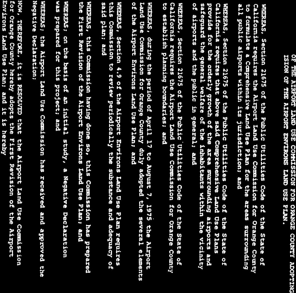
6 SECTION 1.0 INTRODUCTION 1.1 Background In 1967 the first Airport Land Use Commission (ALUC) statute was adopted by the California legislature, according to the California Airport Land Use Planning Handbook. The legislation has been amended many times in the ensuing years. Particularly significant amendments occurred in 1982, 1984, 1994 and The 1982 amendments more clearly articulated the purpose of ALUCs, eliminated the reference to achieve by zoning, required consistency between local general plans and zoning and ALUC compatibility plans, required that local agencies make findings of fact before overriding an ALUC decision and changed the vote required for an override from four-fifths to two-thirds. In 1984, amendments to compatibility plans were limited to once per year and immunity was extended to airports if an ALUC action is overridden by a local agency not owning the airport. In 1994 the California Environment Quality Act (CEQA) statutes as applied to the preparation of environmental documents in the vicinity of airports was amended. Lead agencies are required to use the Airport Land Use Planning Handbook as a technical resource when assessing the airportrelated noise and safety impacts of airport vicinity projects. In 2000, Section 21670(f) was added to clarify that special districts are among the local agencies to which airport land use planning laws are intended to apply. The purpose of ALUCs has remained essentially unchanged since the early years of the statues. To fulfill its purpose ALUC has two specific duties according to the Handbook. Prepare Compatibility Plans Each commission is required to prepare and adopt an airport land use plan for each of the airports within its jurisdiction (Section (c) and 21675(a). Review Local Agency Land Use Actions and Airport Plans The commissions second duty is to review the plans, regulations, and other actions of local agencies and airport operators (Section 21674(d)) The key limitations are 1) that they have no authority over existing land uses regardless of whether such uses are incompatible with airport activities and 2) the powers of the commission shall in no way be construed to give the commission jurisdiction over the operation of any airport. The Airport Land Use Commission for Orange County was established in late Between 1970 and the actual adoption of the AELUP, the Commission made advisory comments on projects. The first AELUP elements were adopted by the Commission between April 17 and August 7, Purpose and Scope This AELUP for Fullerton Municipal Airport is one of several AELUPs prepared for each of the airports in Orange County. Additionally, there is an AELUP for Heliports
7 This land use compatibility plan intends, for the twenty year planning future for Fullerton Municipal Airport (See Appendix D for maps), to safeguard the general welfare of the inhabitants within the vicinity of the airport and to ensure the continued operation of the airport. Specifically, the plan seeks to protect the public from the adverse effects of aircraft noise, to ensure that people and facilities are not concentrated in areas susceptible to aircraft accidents, and to ensure that no structures or activities adversely affect navigable airspace. The implementation of this plan will forestall urban encroachment on the airport and will allow for its continued operation. This compatibility plan for Fullerton Municipal Airport affects the cities of Anaheim, Buena Park and Fullerton, as well as unincorporated areas of the County of Orange. Furthermore, development projects which will exceed 200 feet Above Ground Level (AGL) at their sites may affect any local jurisdiction within the County in that the projects must undergo FAA review and may require referral to the Airport Land Use Commission. 1.3 Authority Public Utilities Code (PUC) 21676(a) requires each local agency whose General Plan includes areas covered by an airport land use commission plan to submit a copy of its general plan or specific plans (each reference to specific plan also includes conventional zoning and planned community zoning) to the airport land use commission. If the plan or plans are inconsistent with the commission s plan, the local agency shall be notified and that local agency shall have another hearing to reconsider its plans. The local agency may overrule the commission after such hearing by a two-thirds vote of its governing body if it makes specific findings that the proposed action is consistent with the purposes stated in Section Section 21676(b) of the Public Utilities Code requires that prior to the amendment of a general plan or specific plan, or the adoption or approval of a zoning ordinance or building regulation within the planning boundary established by the airport land use commission pursuant to Section 21675, the local agency shall first refer the proposed action to the commission. If the commission determines that the proposed action is inconsistent with the commission s plan, the referring agency shall be notified. The local agency may, after a public hearing, overrule the commission by a two-thirds vote of its governing body if it makes specific findings that the proposed action is consistent with the purposes stated in Section Section 21676(c) requires that each public agency owning any airport within the boundaries of an airport land use commission plan shall, prior to modification of its airport master plan, refer each proposed change to the airport land use commission. If the commission determines that the proposed action is inconsistent with the commission s plan, the referring agency shall be notified. The public agency may, after a public hearing, overrule the commission by a two-thirds vote of its governing body if it makes specific findings that the proposed action is consistent with the purposes stated in Section


8
9 Section (d) requires that each commission determination pursuant to subdivision (b) or (c) shall be made within 60 days from the date of referral of the proposed action. If a commission fails to make the determination within that period, the proposed action shall be deemed consistent with the commission s plan. Section (a) and (b) provides that: (a) (b) If the commission finds that a local agency has not revised its general plan or specific plan or overruled the commission by a two-thirds vote of its governing body after making specific findings that the proposed action is consistent with the purposes as stated in Section 21670, the commission may require that the local agency submit all subsequent actions, regulations, and permits to the commission for review until its general plan or specific plan is revised or the specific findings are made. If, in the determination of the commission, an action, regulation, or permit of the local agency is inconsistent with the commission plan, the local agency shall be notified and that local agency shall hold a hearing to reconsider its plan. The local agency may overrule the commission after the hearing by a two-thirds vote of its governing body if it makes specific findings that the proposed action is consistent with the purposes stated in Section Whenever the local agency has revised its general plan or specific plan or has overruled the commission pursuant to subdivision (a), the proposed action of the local agency shall not be subject to further commission review, unless the commission and the local agency agree that individual projects shall be reviewed by the commission. 1.4 Requirements Section of the California Public Utilities Code specifies that the comprehensive land use plans will: "(a)... provide for the orderly growth of each public airport and the area surrounding the airport within the jurisdiction of the commission, and will safeguard the general welfare of the inhabitants within the vicinity of the airport and the public in general. The commission plan shall include and shall be based on a long-range master plan or an airport layout plan, as determined by the Division of Aeronautics of the Department of Transportation, that reflects the anticipated growth of the airport during at least the next 20 years. In formulating a land use plan, the commission may develop height restrictions on buildings, specify use of land, and determine building standards, including soundproofing adjacent to airports, within the planning area. The comprehensive land use plan shall be reviewed as often as necessary in order to accomplish its purposes, but shall not be amended more than once in any calendar year. (see Appendix A for state law) (b) The commission may include, within its plan formulated pursuant to subdivision (a), the area within the jurisdiction of the commission surrounding any federal military airport for all of the purposes specified in subdivision (a)...." - 3 -
10 The Commission is prohibited from exercising any authority over the operations of any airport. 1.5 Concept of the Planning Document This document has been designed to reflect a uniform approach to planning for Fullerton Municipal Airport. Noise and safety impacts have been identified for each airport by using similar standards and criteria except where the size of an airport or type of aircraft operations dictated otherwise. All building height restrictions will have as their ultimate limits the imaginary surfaces as applicable and as defined in Part 77 of the Federal Aviation Regulations. When a project is proposed by an agency, which exceeds the height limits established by FAR Part 77, a determination will be made by the commission on a case by case basis. Land use policies have been established on the basis of noise and safety impacts on the welfare of the public, and on the building height and activity impacts upon the continued operation of the airport. The concepts and processes presented below illustrate the commission's efforts to ensure that land use policies were determined only by the most incontrovertible methods. 1.6 Applicability Section 21670(a)(2) of the Public Utilities Code indicates that a commission s authority is applicable only within areas around public airports to the extent that these areas are not already devoted to incompatible uses Section provides that an airport land use commission that formulates, adopts or amends a comprehensive airport land use plan shall be guided by information prepared and updated pursuant to Section and referred to as the California Airport Land Use Planning Handbook ( Handbook ) published by the Division of Aeronautics of the Department of Transportation. The Handbook advises that while existing development which is incompatible becomes a nonconforming use with respect to ALUC criteria, any redevelopment of those areas would be subject to ALUC policies Existing Land Use is defined by the Commission as a property already devoted to a certain use or a use that has been vested by virtue of the fact that a property developer has: Obtained a valid building permit (as distinguished from merely a foundation or other specific permit); and Performed substantial work; and - 4 -
11 Incurred substantial liabilities in good faith reliance upon the permit. or Entered into a Development Agreement or Obtained a Vesting Tentative Map The Commission believes that the limitation on its authority over existing land uses applies only to the extent that the use remains constant. If new or increased compatibility conflicts would result and to the extent that such land use changes require discretionary approval on the part of a county or city, the Commission policy is to review expansion, conversion, or redevelopment of existing uses Infill development is development proposed in a location where some development already exists. These are commonly residual vacant areas within already established areas. These existing areas may represent either compatible or incompatible land uses within the Commission s planning area for an airport. The Commission recognizes that while a particular non-conforming infill use would likely be inconsistent with its compatibility plan, the introduction of a use which is compatible into a developed area may raise broader community planning issues. The Commission, therefore, will weigh both the severity of the incompatibility and the integrity of the already developed area. Infill projects are those submitted to the Commission pursuant to applicable law which seek to develop residual vacant areas within established neighborhoods. Such existing neighborhoods may represent either compatible or incompatible land uses within an airport s planning areas. An infill project must comply with all applicable Specific Policies (and their associated mitigation measures, such as sound attenuation, height limitation, occupancy limits, etc.) in order to be found consistent with this AELUP. The Commission will not find an infill project to be Consistent with this AELUP, if the project would result in an increase of incompatible land use within the airport s planning areas. Examples of potentially incompatible infill projects include, but are not limited to, the development of: dwelling units within the 65 CNEL Contour, high-occupancy buildings within an APZ, and excessively tall structures deleterious to the navigable airspace The Commission will utilize the following additional criteria in determining consistency/inconsistency of an infill action/project within the applicable planning area(s): The portions of the planning area within which infill is to be permitted (infill within the runway protection zone would be prohibited, for example); - 5 -
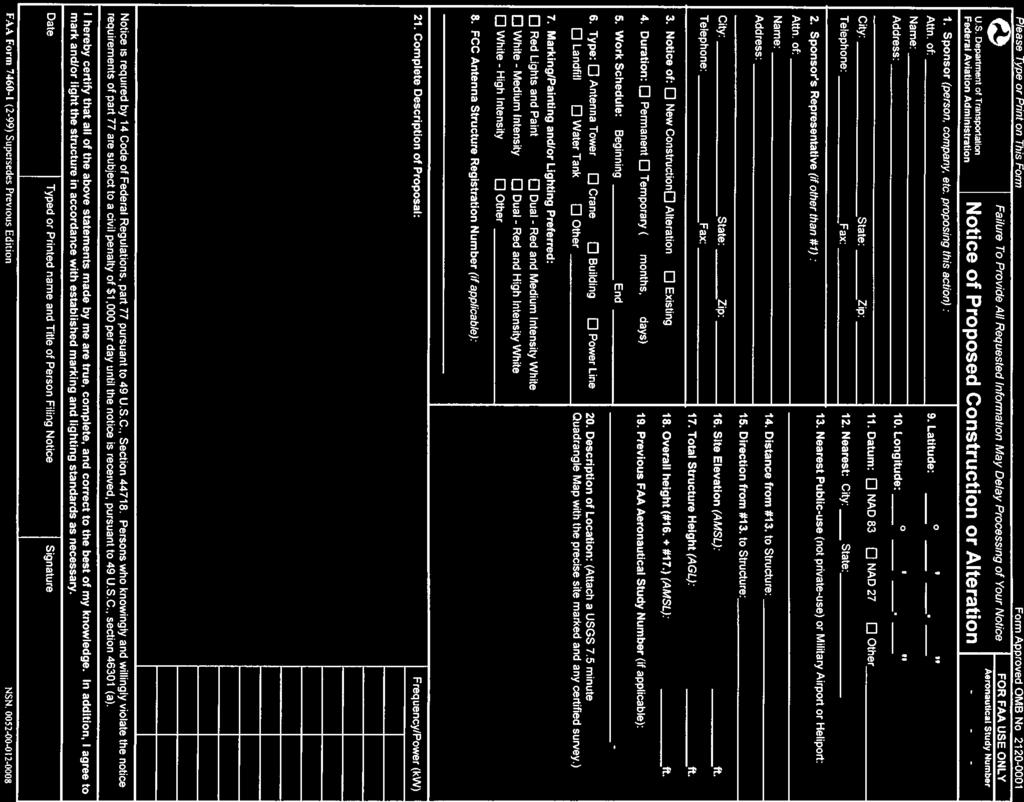
12 The maximum size of a parcel or parcels on which infill is to be allowed; The extent to which the site must be bounded by similar uses (and not extend the perimeter of incompatible uses); The density and/or intensity of development allowed relative to that of the surrounding uses and the otherwise applicable compatibility criteria; and Other applicable development conditions (such as easement dedications or special structural noise level attenuation requirements) which must be met Conditions such as acoustical treatment of structures, recorded deed notices, avigation easement dedication (if offered by a local agency or project proponent), buyer awareness measures, real estate disclosure statements, and building occupancy limits may be considered and applied by the Commission to find an infill project/action consistent. 1.7 Glossary/Definitions ADD AELUP - Average Daily Departure. - Airport Environs Land Use Plan. (A land use compatibility plan referred to in Public Utilities Code Section ) AERONAUTICAL - The technical analysis performed by the Federal Aviation STUDY Administration (FAA) pursuant to the filing of Form Notice of Proposed Construction or Alteration by a project proponent. AICUZ AIRPORT AIRPORT INFLUENCE AREA AIRSPACE ANALYSIS - Air Installations Compatible Use Zones. (A Federal Department of Defense program to identify incompatible land uses around military airports.) - Any public or military airport, airstation, or air facility within Orange County, California. - The area in which current or future airport-related noise, overflight, safety, and/or airspace protection factors may significantly affect land uses or necessitate restrictions on those uses. In most instances, the airport influence area is designated by the ALUC as its planning area boundary for the airport and the two terms can be considered synonymous. - The technical analysis performed by the FAA pursuant to the filing of Form Notice of Landing Area Proposal by a project proponent
13 APZ AVIGATION EASEMENT CNEL COMMISSION db(a) FAA FAR - Accident Potential Zones: (Zones established around some airports based on accident histories and operational characteristics.) - Avigation easement is generally defined by the Caltrans Aeronautics Division as: A type of easement which typically conveys the following rights: a right-of-way for free and unobstructed passage of aircraft through the airspace over the property at any altitude above a surface specified in the easement a right to subject the property to noise, vibrations, fumes, dust, and fuel particle emissions associated with normal airport activity; a right to prohibit the erection or growth of any structure, tree, or other object that would enter the acquired airspace; a right-of-entry onto the property with proper advance notice for the purpose of removing, marking, or lighting any structure or other object that enters the acquired airspace; a right to prohibit electrical interference, glare, misleading lights, visual impairments, and other hazards to aircraft flight from being created on the property. (Caltrans Division of Aeronautics California Airport Land Use Planning Handbook dated January 2, 2002 or as revised by Caltrans; Appendix D, pp. D-3/4). A sample avigation easement is included in Appendix J. - Community Noise Equivalent Level [CNEL is the energy average noise level measured in A-level for a 24-hour period, with different weighting factors for the hourly noise levels occurring during the daytime (0700 to 1900, 0 db weighting), evening (1900 to 2200, 5 db weighting), and nighttime (2200 to 0700, 10 db weighting) periods.] - The Airport Land Use Commission for Orange County - A-Weighted sound pressure level or A-level is the sound pressure level which has been filtered or weighted to quantitatively reduce the effect of the low frequency noise. It was designed to approximate the response of the human ear to sound. A-level is measured in units of decibels. - Federal Aviation Administration. - Federal Aviation Regulations. FREE-STANDING - A building which does not share a common wall BUILDING with another building
14 HABITABLE ROOM - Any room meeting the requirements of the Uniform Building Code or other applicable regulations which is intended to be used for sleeping, living, cooking or dining purposes, excluding such enclosed spaces as closets, pantries, bath or toilet rooms, service rooms, connecting corridors, laundries, unfinished attics, foyers, storage spaces, cellars, utility rooms and similar spaces. HELIPORT HELISTOP INFILL - An identifiable area on land or water, including any building or facilities thereon, used or intended to be used for the landing and takeoff of helicopters. Does not include temporary landing and takeoff sites, as defined in the California Aeronautics Act. Refueling and overnight maintenance are permitted. - An identifiable area on land or water, including any building or facilities thereon, used or intended to be used for the landing and takeoff of helicopters. Does not include temporary landing and takeoff sites. Refueling and overnight maintenance are not permitted. - Development which takes place on vacant property largely surrounded by existing development, especially development which is similar in character. LOCAL AGENCY - The County of Orange, or any city or special district within Orange County. NEW AIRPORT NOISE DISCLOSURE NOTICE OF AIRPORT IN VICINITY OBSTRUCTION - Any new public airport that is proposed to be constructed and operated by a local agency such as county(ies), city(ies), or special district(s) or authorities. - Appropriate written notification, usually in the form of avigation easement, deed notice, or real estate disclosure statement, or final tract or parcel map, which informs the future resident of aircraft noise. Noise disclosure methodology is presented in AELUP Section Notice disclosure defined by Section of the Business and Professions Code. - Any object of natural growth, terrain or permanent or temporary construction or alteration, including equipment or materials used therein, the height of which exceeds the standards established in Subpart C of Federal Aviation Regulations Part 77, Objects Affecting Navigable Airspace
15 OPERATION OUTDOOR LIVING AREAS OVERRIDE - Any single landing or approach performed by an aircraft. Also any single take-off or departure constitutes an operation. - Spaces that are associated with residential land uses typically used for passive recreational activities or other noise-sensitive uses. Such spaces include patio areas, barbecue areas, jacuzzi areas, etc. associated with residential uses; outdoor patient recovery or resting areas associated with hospitals, convalescent hospitals, or rest homes; outdoor areas associated with places of worship which have a significant role in services or other noisesensitive activities; and outdoor school facilities routinely used for educational purposes which may be adversely impacted by noise. Outdoor areas usually not included in this definition are: front yard areas, driveways, greenbelts, maintenance areas, and storage areas associated with residential land uses; exterior areas at hospitals that are not used for patient activities; outdoor areas associated with places of worship and principally used for shortterm social gatherings. - See Overrule below. OVERRULE - The formal procedure set forth in PUC Sections , 21676, , and whereby a local agency s governing body may overrule an ALUC determination of inconsistency. PLANNING AREA PUC - Public Utilities Code Section 21675(c) requires that area surrounding any airport which affects, or is affected by, aircraft operations be embraced by the boundaries of its compatibility plan. The planning area sets limits of the area within which proposed land use projects are to be referred to the ALUC for review. With certain exceptions, planning area boundaries are determined by the location and configuration of the airport included in the plan, and the extent of the noise and safety impacts associated with that airport. The overall planning area is the furthest extent of the 60 CNEL Contour, the FAR Part 77 Notification Surface and the runway safety zones associated with the airport. - Public Utilities Code of the California Codes REDEVELOPMENT - The expansion or conversion of an existing land use, whether compatible or incompatible within an airport environs, which would result in an intensified use, or in a new use which may or may not be compatible
16 RUNWAY - A trapezoidal area off each end of a runway used to enhance PROTECTION the protection of people and property on the ground. The ZONE (CLEAR ZONE) innermost of the safety zones. SINGLE EVENT - In decibels, shall mean the sound exposure level of a single event, NOISE EXPOSURE such as an aircraft fly-by, measured over the time interval LEVEL (SENEL) between the initial and final times for which the sound level of a single event exceeds the threshold sound level. SENEL is an A- weighted measure of an individual flyover, which time-integrates the level accumulated during this event with reference to a duration of one second. Because of this integration process, SENEL takes into consideration both the duration and the magnitude of the noise signal
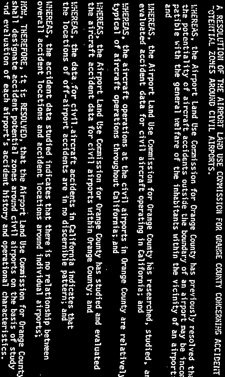
17 SECTION PLANNING GUIDELINES Guidelines for airport land use planning have been set down in a variety of cohesive approaches and systematic forms. Civilian and military authorities have established regulations or statutes which specify numerous methodologies for mitigating the incompatibilities between an airport and its environs, and such incompatibilities have been adequately defined. Public Utilities Code Section et. seq. provides general planning and procedural guidance while directing a land use commission to provide "for the orderly growth of each public airport and the area surrounding the airport," and to "safeguard the general welfare of the inhabitants within the vicinity of the airport and the public in general." Toward these ends, Sections and further enables the Commission to "develop height restrictions on buildings", to specify the "use of land", to determine "building standards, including sound-proofing"; and to "assist local agencies in ensuring compatible land uses in the vicinity of all new airports and in the vicinity of existing airports to the extent that the land in the vicinity of those airports is not already devoted to incompatible uses." The Commission is also empowered to "coordinate planning at the state, regional and local levels so as to provide for the orderly development of air transportation, while at the same time protecting the public health, safety, and welfare." The California Department of Transportation s California Airport Land Use Planning Handbook, provides further guidelines, which the commission is bound by law to utilize in the preparation of this AELUP. Similarly, legislation passed in 1994 requires that, when preparing an environmental impact report for any project situated within an airport influence area as defined in an ALUC compatibility plan (or, if a compatibility plan has not been adopted, within two nautical miles of a public-use airport), lead agencies shall utilize the Handbook as a technical resource with respect to airport noise and safety compatibility issues. (Public Resources Code, Section 21096) In the formulation and amendment of this plan, the Commission has made every effort to study and to evaluate all available viewpoints regarding airport land use planning. Historically, the Commission has held formal public hearings to gather input in addition to its key reliance on the Caltrans Handbook 2.1 Standards and Criteria The following sections describe the standards and criteria adopted by the Airport Land Use Commission for Orange County for establishing planning boundaries and the reasoning of the Commission in choosing them Aircraft Noise In adopting the Community Noise Equivalent Level Methodology, Resolution No of the Airport Land Use Commission for Orange County states that: "... aircraft noise emanating from airports may be incompatible with the general welfare of the inhabitants within the vicinity of an airport and in order to measure the impact of aircraft noise on inhabitants within the vicinity of an
18 airport, the Airport Land Use Commission for Orange County adopts the Community Noise Equivalent Level Methodology as specified in the Noise Standards for California Airports (Title 21, California Code of Regulations)." Historically, the Commission investigated other aircraft noise description systems including Composite Noise Rating, Noise Exposure Forecast, Noise and Number Index, and Aircraft Sound Description System. The Commission discussed at length the variability of aircraft noise due to atmospheric conditions and aircraft operations and the inability of any sound measurement system to provide a completely accurate noise description at all times. The Community Noise Equivalent Level (CNEL) system was adopted by the Commission for the following reasons: (1) the system is set forth in the State Code of Regulations (Title 21, California Code of Regulations) and therefore is imbued with legal authority; and (2) the Noise Insulation Standards in the State Housing Law (Title 25, California Code of Regulations) specify the use of the CNEL system to describe intrusive noise levels and prescribe soundproofing; and (3) the CNEL system most accurately describes those noise levels prescribed in the Noise Element of the Orange County General Plan. The 60 db CNEL contour line was chosen as a planning boundary by the Commission for the following reasons: (1) this level is prescribed in the California Noise Insulation Standards as the criterion for enforcing the use of sound insulation; and (2) the flexible nature of a CNEL contour requires that some leeway from the 65 db level, prescribed in the Noise Standards for California Airports, be created in order to protect inhabitants of the airport environs from noise. The CNEL methodology has been adopted for, and applies to, all airports in Orange County, both civilian and military Accident Potential Zones (Civilian Airports) In adopting criteria for Accident Potential Zones at civilian airports, Resolution No of the Airport Land Use Commission for Orange County states that: "... the Airport Land Use Commission for Orange County shall designate accident potential zones around civil airports on the basis of study and evaluation of each airport's accident history and operational characteristics." Instead of adopting one methodology to be applied to all civilian airports, the
19 Commission decided to study each airport individually. In the past, the Commission has evaluated data from all airport accidents occurring within California and at each civilian airport in the County; and concluded that there was insufficient evidence to identify crash hazard zones which were applicable to all airports. Periodic reviews of accident patterns will be undertaken by the Commission as new data and methodologies become available. Justification for designating accident potential zones around civilian airports such as Fullerton Municipal Airport is detailed in Section 2.2. APZs for FMA are known as Runway Protection Zones (RPZs) Building Height Restrictions In adopting criteria for building height restrictions in the vicinities of airports, the Commission considered only one standard and that was Federal Aviation Regulations Part 77 (FAR Part 77) entitled, "Objects Affecting Navigable Airspace." These regulations are the only definitive standard available and the standard most generally used. In order to ensure that buildings which might affect the continued operations of airports are not built in their vicinities, the Commission has incorporated the standards for determining obstructions and FAR Part 77 definitions, of the "imaginary surfaces" for airports, as the guidelines for height limits. The "imaginary surfaces" are defined by means of elevations, heights and slopes in relation to individual airports, the spaces above which are reserved to air navigation. In addition to the "imaginary surfaces", the Commission will use all of the FAR Part standards along with the results of FAA aeronautical studies, or other studies deemed necessary by the Commission, in order to determine if a structure is an "obstruction." Building or structural heights are limited to the distance between the ground elevation of the site and an elevation that has been determined will not adversely effect an airport or aeronautical operations, nor navigational-aid siting criteria, including interference with navigational-aids or published flight paths and procedures. The Commission utilize criteria for protecting aircraft traffic patterns at individual airports which may differ from those contained in FAR Part 77, should evidence of health, welfare, or air safety surface sufficient to justify such an action. Commission review of individual cases will be guided by FAR Part 77, and by FAA Advisory Circular No. 150/5190-4A, as published on December 14, 1987 and entitled "A Model Zoning Ordinance to Limit Height of Objects Around Airports" (Appendix F). This document has been promulgated by the FAA expressly to guide local agencies in the preparation of specialized zoning regulations, and in the conduct of individual case reviews. The Advisory Circular complements FAR Part 77, and together they provide an overall means to protect the navigable airspace at local airports
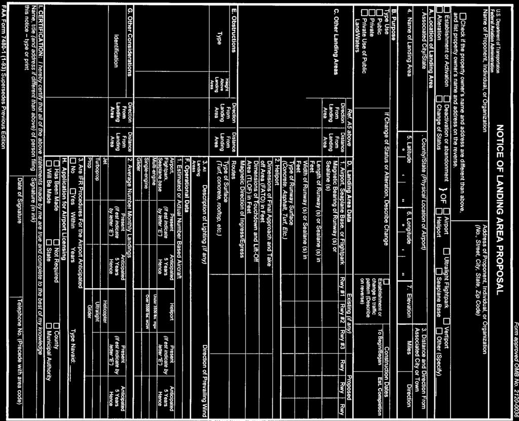
20 The results of an aeronautical study conducted by the FAA pursuant to FAR Part will be utilized to determine if a structure will have an adverse effect on the airport or on aeronautical operations. The Commission considers and recognizes the FAA as the single "Authority" for analyzing project impact on airport or aeronautical operations, or navigational-aid siting, including interference with navigational-aids or published flight paths and procedures. The Commission also considers the FAA as the "Authority" for reporting the results of such studies and project analyses. The Commission will not consider the findings of reports or studies conducted by parties other than the FAA unless the FAA certifies and adopts such findings as true and correct. In those portions of the height restriction planning areas that lie outside of the Clear or Accident Potential Zones and 60 db CNEL Contours, or other areas of special concern as delineated by the FAA and adopted by the Commission, local agencies are required to submit only those matters which contemplate structures that would penetrate the imaginary surfaces as defined in FAR Part 77.13, 77.25, or which have been designated for each individual airport for height restriction referral Air Transportation The Commission is charged by PUC Section to coordinate planning at the state, regional, and local levels, so as to provide for the orderly development of air transportation while, at the same time, protecting the public health, safety and welfare. The preparation and dissemination of the AELUP are themselves important long-term steps in fulfilling this duty Airports/Heliports/Helistops The Commission is charged with reviewing and acting on proposed airport master plans, expansion of existing airports, and plans for construction of new airports and heliports within its jurisdiction and with making recommendations directly to the California Department of Transportation/Aeronautics Division, regarding the state airport/heliport permit under Section of the California Public Utilities Code. Heliports/helistops to be located at an existing airport do not require Commission review. The Commission review of proposed projects for airports/heliports/helistops is initiated by the local agency's referral of the proponent's request for a development permit to construct and operate an airport/heliport/helistop. (Note that per Section 3534(b)(5) of the California Code of Regulations, a referral for a heliport/helistop may be directly from the applicant/sponsor.) A finding by the Commission regarding consistency of the proposed project with this plan will be forwarded to the local jurisdiction for their consideration
21 The information needed for review of the proposed airport/heliport/helistop by the Commission includes the following: 1. Location of the proposed airport/heliport/helistop (street address). 2. Purpose of request: Personal, private, or commercial use of airport/ heliport/helistop. 3. General Plan and zoning of the site. 4. Description of area and adjoining properties. 5. Approach/departure paths. 6. Anticipated number of approaches and departures (counted separately) during a specified time interval (day, week, month). 7. Potential for creating a nuisance due to noise generated by the operation of fixed-wing aircraft and helicopters (Noise Study may be required). 8. Potential for creating an accident hazard (Accident Probability Study may be required). 9. Federal Aviation Administration Airspace Analysis. (Form 7480) 10. Type of craft proposed to be used and noise output of craft. 11. Description of proposed operations/facilities (maintenance, refueling, etc.) Policies and criteria for heliports can be found in the ALUC s separate Airport Environs Land Use Plan for Heliports Planning Areas - Airports Designated planning areas for each Airport are set forth in Section 2.2. (See Appendix D) The Commission evaluated the factors germane to its mandated duties and decided that the planning areas shall be based on the following criteria: 1. Areas that are within the 60 db CNEL contour, as specified for each individual Airport in Section 2.2 of the AELUP. 2. Areas that are within the Clear Zones/Runway Protection Zones or Accident Potential Zones, as specified for each individual airport in Section 2.2 of the AELUP
22 3. Areas subject to building height restrictions, as specified for each individual airport in Section 2.2 of the AELUP. 4. In addition to the criteria listed above in items 1-3, the entire County shall be deemed within the Commission's planning area for development proposals (as defined in PUC Section 21676(b)) which are: a. Germane to air transportation i.e., sites of developments whose proposed populations are so large as to have an effect on air transportation. b. Outside the height restriction planning area specified for each individual airport in Section 2.2 of the AELUP, but which are planned to be built to a height of more than 200 feet above ground level, and which in the opinion of the local agency, the FAA, or the Commission, may pose an adverse aeronautical effect, as generally defined in AELUP Section 3.2.1, must be submitted to the Commission. c. Within 10,000 feet from the nearest point of the nearest runway of less than 3,200' in length at FMA, which in the opinion of the local agency, the FAA, or the Commission would interfere with visual or electronic navigation systems or would threaten the operation of an airport or decrease its utility, by producing or causing excessive glare, light, steam, smoke, dust, electronic interference, or by attracting birds, must be submitted to the Commission. In those portions of the planning areas that lie outside of the Clear Zones/Runway Protection Zones or Accident Potential Zones and 60 db CNEL contours or other areas of special concern as specified in Items 4a, 4b, or 4c, local agencies are required to submit only those matters which contemplate or permit structures that would penetrate the imaginary surfaces as defined in FAR Part 77.13, 77.25, or which have been designated for each individual airport for height restriction referral. A local jurisdiction's legislative acts (general plan or specific plan amendments, including conventional zoning and Planned Communities, zoning ordinances or building regulations and airport plans) shall be referred to the Commission pursuant to Public Utilities Code Section 21676(b) Planning Areas New Airports Public Utilities Code Section states that no application for the construction of a new airport may be submitted to any local, regional, state or federal agency unless that plan has been both: 1. Approved by the board of supervisors of the county, or the city council of the city, in which the airport is to be located; and 2. Submitted to and acted upon by the Commission
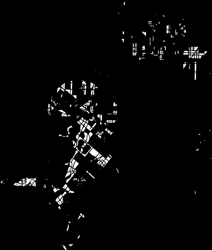
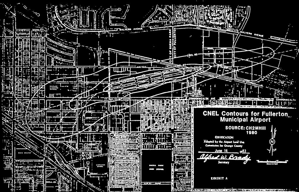
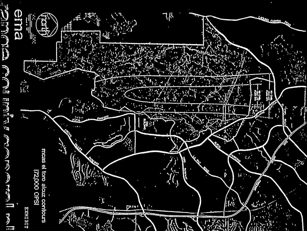
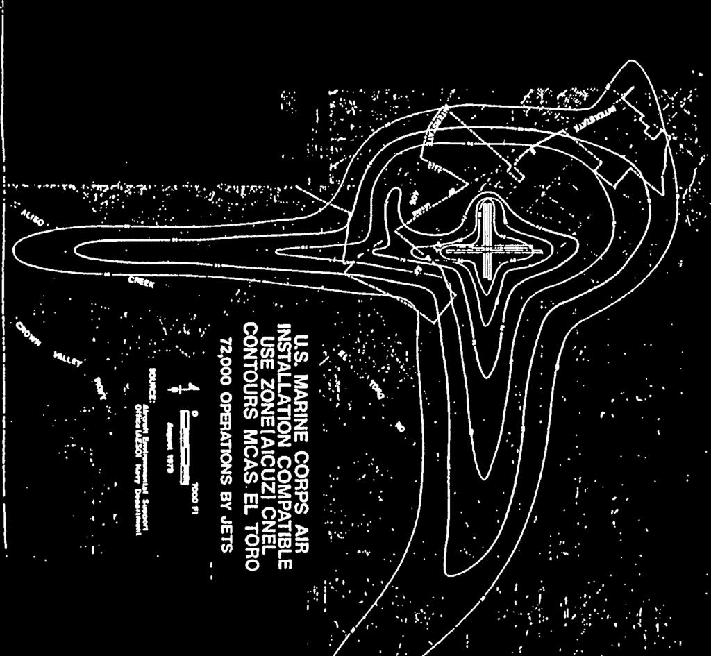
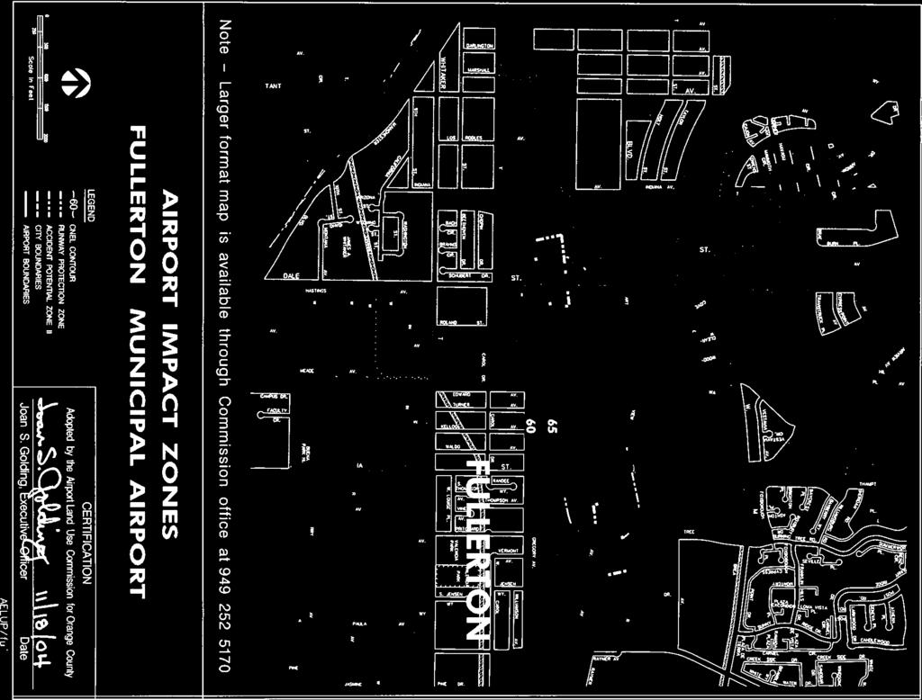
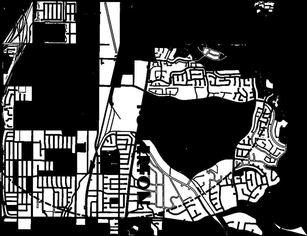
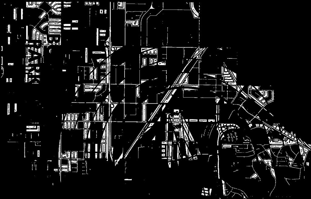
23 During the process by the local land use authority and the FAA to certify/approve an EIR/EIS and a Master Plan for the development of a new airport, the Commission shall review the EIR/EIS and/or Master Plan for consistency with, and possible future inclusion in, Section 2.2 of the AELUP. The Commission will adopt the projected noise contours presented in the EIR/EIS and/or Master Plan based on the selected alternative runway alignment and future operational projections. Likewise, the Commission will adopt the FAR Part 77 - height restriction criteria based on the selected alternative or Master Plan project. These will form the basis for the planning area for Commission referral until revised data can be generated based on an evaluation of actual operations. New or amended accident Potential and Clear Zones/Runway Protection Zones may be considered for possible establishment as a planning area if called for as a mitigation in the EIR/EIS or included in the Master Plan. Other factors such as light and glare or smoke will also be considered if called for in the EIR/EIS and/or Master Plan. 2.2 Establishment of Planning Areas In adopting the various standards and criteria, the Commission applied several appropriate systems and methodologies to the individual airports. The following section details the considerations of the Commission in fixing the particular contours and boundaries around Fullerton Municipal Airport Fullerton Municipal Airport, FMA HISTORY, SETTING, AND ROLE Fullerton Municipal Airport (FMA) is located 22 miles southeast of metropolitan Los Angeles at the western edge of the city of Fullerton in highly urbanized northern Orange County (see Figure 1 and Appendix D). Beginning as early as 1913 when barnstormers and crop dusters used the vacant 53-acre former sewer farm as a makeshift landing site, FMA was the site of numerous aviation firsts while evolving through such phases as Chamber of Commerce stewardship to wartime military utilization to city owned and operated transportation center. Now comprised of 86 acres, FMA serves transient general aviation aircraft, as well as the approximately 350 piston/turbine fixed-wing and rotary-wing aircraft based there. In this capacity, FMA also fulfills its role as the significant general aviation reliever airport for John Wayne Airport in Orange County. CNEL CONTOURS - The Commission utilized the contours developed by P&D Aviation for the City of Fullerton during (Appendix D). These contours are based on approved noise modeling techniques using FAA Air Traffic Control Tower records and sound recordings, and represent the most accurate data available for the busiest recent operations year (2002)
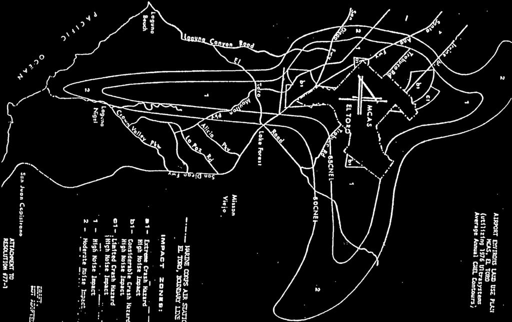
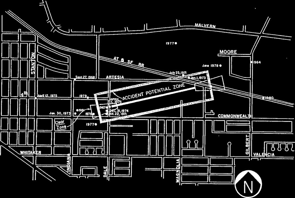
24 RUNWAY PROTECTION ZONES / ACCIDENT POTENTIAL ZONES - The Commission analyzed the accident history of Fullerton Airport and concluded that the significant number of accidents justified the establishment of an Accident Potential Zone "RPZ" (Runway Protection Zone) for land use planning purposes at each runway end beginning 200 feet beyond the displaced thresholds and extending outward for a linear distance of 1,000, and an Accident Potential Zone "II" within 500 feet of the runway centerline beyond the areas of the RPZ and the airport proper, as shown in Appendix D on the map entitled Fullerton Municipal Airport Impact Zones. Per the FMA Manager, from 1984 through September 2004, twenty aircraft accidents occurred within two miles of the airport in the cities of Fullerton and Buena Park. This, plus the lack of airport ownership of the entire runway protection zones at the runway ends, has convinced the Commission that the runway protection / accident potential zones depicted on the map are justified. BUILDING HEIGHT RESTRICTIONS For Fullerton, the Commission, by reference, has adopted Part 77, Objects Affecting Navigable Airspace, of the Federal Aviation Regulations as a guideline to describe the ultimate height of structures under the "imaginary surfaces" as defined in FAR Part 77. These airspace imaginary surfaces for FMA now include a second set of FAA-mandated RPZs which extend farther from the respective runway ends than the separate land use RPZs discussed and depicted in the context of accident potential zones, above. These heightrestriction FAR Part 77 RPZs represent imaginary surfaces beyond the runway ends through which no physical objects should penetrate, per FAA policy. These RPZs, which rise from points 200 feet beyond the ends of the runway surface and which extend outward for a linear distance of 1,000 feet at a slope ratio of 20:1, are depicted on the Height Restriction Zone Map in Appendix D. Additional imaginary surfaces so depicted include the ground-level Primary Surface, the 7:1 Transitional Surfaces, the 5,000-foot radius Horizontal Surface, and the 20:1 Conical Surface. Structures should not exceed the elevations defined in FAR Part unless, upon completion of an aeronautical analysis conducted by the FAA pursuant to FAR Part 77.13, the Commission finds that they will be consistent with the Policies of Section 3.2 of the AELUP. In addition to the imaginary surfaces, the Commission will use all of the FAR Part standards for determining if a structure is an obstruction. Structural height is limited to the distance between the ground elevation of the site and an elevation which the FAA has determined will not adversely affect this airport or its aeronautical operations, including interference with navigational-aids or published flight paths and procedures. The Commission may consider the utilization of criteria for protecting aircraft traffic patterns at this airport which may differ from those contained in FAR Part 77, should evidence of health, welfare, or air safety surface sufficient to justify such an action. The Commission will utilize the results of an aeronautical study, conducted by the FAA pursuant to FAR Part 77.13, in order to determine if a structure will have an adverse effect on the airport or on aeronautical operations
25 PLANNING AREAS - The Commission has adopted and defined as its Planning Areas for Fullerton Municipal Airport all area within the 60 db CNEL Contour, all area within the Runway Protection and Accident Potential Zones, and all area that lies above or penetrates the 100:1 "imaginary surface" as defined in FAR Part Outside of the 60 db CNEL Contour and the Runway Protection and Accident Potential Zones, or other areas of special concern as delineated by the FAA and adopted by the Commission, local agencies are required to submit only those matters which contemplate or permit structures that would penetrate the 100:1 imaginary surface for notice to the FAA as defined in FAR Part TWENTY YEAR FUTURE - The Fullerton Municipal Airport Master Plan Update indicates that a modest increase in operations is forecast although the present level of operations will remain relatively constant for the foreseeable future. The Commission utilized the 2004 Fullerton Municipal Airport Master Plan Update prepared by P&D Aviation, as a guideline for establishing its planning areas
26 SECTION LAND USE POLICIES 3.1 Concept To fulfill the purpose of this plan, land use within the planning area boundaries of the AELUP must conform to noise, safety and height restriction standards. Section 3.0 sets forth both the General Policy and Specific Policies pertaining to land use. The General Policy outlines the land use standards for the planning areas. The Specific Policies clarify the General Policy. Impact areas are denoted either on maps (appended) or by reference to some standard source. 3.2 Land Use Policies General Policy The General Land Use policy of the Airport Land Use Commission for Orange County shall be: Within the boundaries of the AELUP, any land use may be found to be Inconsistent with the AELUP which; (1) Places people so that they are affected adversely by aircraft noise, (2) Concentrates people in areas susceptible to aircraft accidents, (3) Permits structures of excessive height in areas which would affect adversely the continued operation of the airport, or (4) Permits activities or facilities that would affect adversely aeronautical operations. Adverse effects of aircraft noise are defined by the "reasonable person" concept presented in the Noise Standards for California Airports, Title 21 of the California Code of Regulations (Appendix H). Adverse effects of aircraft noise include single event noise disturbances to which people near airports are subjected. A concentration of people in an area susceptible to aircraft accidents is defined as a number of people situated on the ground so as to increase the potential magnitude of a major crash catastrophe (i.e., a larger number of fatalities or injuries than otherwise may occur). Adverse effect of structure height refers to a structure of such height and/or location that its existence would threaten the continued operation of the airport, or would decrease the airport s utility, such as by creating an obstacle in the flight paths or other aircraft traffic patterns employed at the airport, or by interfering with visual or electronic navigation systems
27 Adverse effect of activities or facilities refers to a land use that would hamper aeronautical operations within the boundaries of the AELUP of an airport by producing or causing excessive glare, light, steam, smoke, dust or electronic interference, or by attracting birds. Any land use which is in conformance with this general policy shall be consistent with the AELUP. Any land use which is not in conformance with this general policy shall be inconsistent with the AELUP Specific Policies Some proposed land uses as normally designed and constructed may be found to be inconsistent with the AELUP by the Commission on a case-by-case basis. Other land uses may be found to be consistent with the AELUP by the Commission provided that certain conditions, mitigations, or design measures as described in the following Sections are utilized. Examples of limitations on land uses due to noise are set forth in Table
28 TABLE 1 AIRPORT LAND USE COMMISSION FOR ORANGE COUNTY AIRPORT ENVIRONS LAND USE PLAN LIMITATIONS ON LAND USE DUE TO NOISE (Applicable to Aircraft Noise Sources) LAND USE CATEGORY Residential (all types): Single and Multi-Family Residences Community Facilities: Churches, Libraries, Schools, Preschools, Day-Care Centers, Hospitals, Nursing/Convalescent Homes, & Other noise sensitive uses COMMUNITY NOISE EQUIVALENT LEVEL db Commercial: Retail, Office Industrial: NORMALLY CONSISTENT Conventional construction methods used. No special noise reduction requirements. CONDITIONALLY CONSISTENT Must use sound attenuation as required by the California Noise Insulation Standards, Title 25, California Code of Regulations. Residential use sound attenuation required to ensure that the interior CNEL does not exceed 45 db. Commercial and industrial structures shall be sound attenuated to meet Noise Impact Zone "1" criteria (refer to Section 3.2.3). NORMALLY INCONSISTENT All residential units are inconsistent unless are sound attenuated to ensure that the interior CNEL does not exceed 45 db, and that all units are indoor oriented so as to preclude noise impingement on outdoor living areas
29 3.2.3 Noise Impact Zone "1" - High Noise Impact (65 db CNEL and Above) Noise impact in this zone is sufficient to warrant restrictions on residential uses and to require sound attenuation measures on other uses. All,residential units are inconsistent in this area unless it can be shown conclusively that such units are sufficiently sound attenuated for present and projected noise exposures, which shall be the energy sum of all noise impacting the project, so as not to exceed an interior standard of 45 db CNEL, with an accompanying dedication of an avigation easement for noise to the airport proprietor applicable to single family residences, multi-family residences and mobile homes. Furthermore, all residential units are to be sufficiently indoor oriented so as to preclude noise impingement on outdoor living areas, as defined in Section 1.7. Noise-sensitive institutional uses such as schools, churches, hospitals, libraries, and other noise-sensitive uses may also be inconsistent in this zone. All noise sensitive uses are inconsistent in this area unless it can be shown conclusively that such units are sufficiently sound attenuated for present and projected noise exposures, which shall be the energy sum of all noise impacting the project, so as not to exceed an interior standard of 45 db CNEL, and may require the dedication of an avigation easement for noise to the airport proprietor. Commercial, industrial, and recreational uses may be acceptable in this zone providing that commercial and industrial structures are sufficiently sound attenuated to allow normal work activities to be conducted. Said structures shall be sound attenuated against the combined input of all present and projected exterior noise to meet the following criteria: Typical Use Level L (eq)*(12)** Private office 1, church sanctuary, board room, conference room, etc. General office 1, reception, clerical etc. Bank lobby, retail store, restaurant, typing pool, etc. Manufacturing, kitchen, warehousing, etc. 45 db(a) 50 db(a) 55 db(a) 65 db(a) * L(eq) is the equivalent sound level for a specified time period in db(a). ** Measured from 7:00 a.m. to 7:00 p.m. or other appropriate, approved time period Noise Impact Zone "2" - Moderate Noise Impact (60 db CNEL or greater, less than 65 db CNEL) 1 An enclosed office intended for use by an individual. 1 An open office intended to have more than one work station
30 Noise impact in this area is sufficient to require sound attenuation as set forth in the California Noise Insulation Standards, Title 25, California Code of Regulations. Single noise events in this area create serious disturbances to many inhabitants. Even though the Commission would not find residential units incompatible in this area, the Commission strongly recommends that residential units be limited or excluded from this area unless sufficiently sound attenuated. The residential use interior sound attenuation requirement shall be a CNEL value not exceeding an interior level of 45 db Land Use Runway Protection Zone RPZ, Extreme Crash Hazard The severe potential for loss of life and property due to accidents prohibits most land uses in this area. Also, the close proximity to aircraft operations limits land uses which would endanger such operations. Only airport-related uses and open space uses, including agriculture and certain types of transportation and utility uses are permitted. No buildings intended for human habitation are permitted in the RPZ. Furthermore, because of the proximity to aeronautical operations, uses in this area must not attract birds nor emit excessive glare or light, nor produce or cause steam, smoke, dust, or electronic interference so as to interfere with, or endanger, aeronautical operations Accident Potential Zone I APZ I, Considerable Crash Hazard The potential for loss of life and property due to aircraft accidents is sufficient to require density and intensity of use restrictions in this zone. In accordance with the General Policy, the Commission would find unacceptable any land use where lot coverage exceeded fifty (50) percent or where more than one hundred (100) persons were placed for long periods in a structure (i.e., a free-standing building). All forms of residential uses are unacceptable in this zone, as are places of indoor or outdoor assembly (i.e., churches, schools, conference centers, restaurants, etc.). Open space, commercial, industrial, and airport-related uses are acceptable in this zone providing they adhere to the density and intensity of use restrictions. Furthermore, because of the proximity to aeronautical operations, uses in this area must not emit excessive glare or light, nor produce or cause steam, smoke, dust, or electronic interference so as to interfere with, or endanger, aeronautical operations. Currently there is no APZ I shown for FMA Accident Potential Zone II APZ II, Limited Crash Hazard The potential for loss of life and property due to aircraft accidents is sufficient to require density and intensity of use restrictions in this zone. In accordance with the General Policy, the Commission would find unacceptable any land use where lot coverage exceeded seventy-five (75) percent or where more than two hundred (200) persons were placed for long periods in an open assembly area or in a structure (i.e., a free-standing building). Most forms of open space, industrial, commercial, and airport-related uses are acceptable, whereas residential and public facilities (schools, churches, etc.) are not acceptable. Furthermore, because of the proximity to
31 aeronautical operations, uses in this area must not emit excessive glare or light, nor produce or cause steam, smoke, dust, or electronic interference so as to interfere with, or endanger, aeronautical operations. In applying the APZ standards, the Commission considers a free-standing building as one structure despite the existence of fire walls that may separate tenants or users. Furthermore, the Commission considers that if a structure crosses over boundary lines of APZs I or II, or over a boundary between a non-crash hazard area and an APZ, then the entire building shall be considered to be in the more restrictive APZ area regarding density standards Height Restriction Zone Any object, which by reason of its height or location would interfere with the established, or planned, airport flight procedures, patterns, or navigational systems, is unacceptable to the Commission. Similarly, any proposal which would cause a diminution in the utility of an airport is unacceptable to the Commission. The standards, criteria, and procedures promulgated by the FAA for the thorough evaluation of development projects are designed to ensure the safe and efficient use of the navigable airspace. The application of these principles by the Commission will ensure the stability of local air transportation, as well as promote land uses that are compatible with the airport environs. However, any object which rises above the height of surrounding development, or which is located in close proximity to any of the various flight paths, must be clearly visible during hours of twilight or darkness and must not threaten, endanger, or interfere with aeronautical operations. Such objects, even if within the above height restrictions, are not acceptable to the Commission unless they are clearly marked or lighted according to FAA standards Airspace/Airport Inconsistency In reviewing projects, the Commission will find any structure, either within or outside of the planning areas, inconsistent with this AELUP if it: 1. Is determined to be a "Hazard" by the FAA; 2. Would raise the ceiling or visibility minimums at an airport for an existing or planned instrument procedure (i.e., a procedure consistent with the FAA-approved airport layout plan or a proposed procedure formally on file with the FAA); 3. Would result in a loss in airport utility, e.g. in a diminution of the established operational efficiency and capacity of the airport, such as by causing the usable length of the runway (s) to be reduced; or 4. Would conflict with the VFR air space used for the airport traffic pattern or enroute navigation to and from the airport
32 Avigation Easements The dedication of an avigation easement in favor of an airport proprietor is designated as a method which may be employed by airport proprietors for controlling and reducing noise problems surrounding airports, pursuant to Title 21, California Code of Regulations, Section See Appendix J for Section Therefore, in recognition of Section 5037 and in order to codify long-standing Commission policy and practice as exemplified by Airport Land Use Commission Resolution 79-2, the continuing policy of the Commission is that an avigation easement may be considered by the Commission if so requested by a local agency or project proponent as a factor which may render a land use, within the AELUP planning area set forth in Section (Noise Impact Zone 1 ), consistent with the AELUP. However, nothing in this section shall be deemed to confer upon the Commission the legal jurisdiction or authority to require, compel or mandate the dedication of an avigation easement as a condition of consistency; and the lack of an avigation easement shall not constitute the basis for a determination by the Commission that a project is inconsistent with the AELUP. This section is applicable only to projects submitted to the Commission by local agencies after the adoption of the revisions set forth herein and only to projects within the subject matter jurisdiction of the Commission. 3.3 Specific Policies for Consistency Determinations As set forth in Public Utilities Code Sections and and as discussed in the Caltrans California Airport Land Use Planning Handbook, a key responsibility of an airport land use commission is to review particular types of local actions for compliance with the criteria and policies set forth in a commission s adopted compatibility plan Section 3.0 of the Airport Environs Land Use Plan sets forth the policies and criteria by which a local action can be reviewed, and a determination made of its consistency/inconsistency with the AELUP The ALUC may find a local action consistent with the AELUP; or The ALUC may find a local action consistent with the AELUP with condition(s) attached if the local agency/project proponent offer such conditions. These condition(s) serve to mitigate a project which would otherwise be found inconsistent with the AELUP; or The ALUC may find an action inconsistent with the AELUP Examples of conditions which may serve to mitigate a project/action and thus may permit the ALUC to make a finding of consistency include the following:
33 Requirement for the lighting of structures per FAA Standards as set forth in FAA Advisory Circular 70/7460-1J Obstruction Marking and Lighting. Specification of maximum density of residential development Specification of maximum intensity of non-residential development Appropriate written notification, (as set forth in the Noise Disclosure and Notice of Airport in Vicinity definitions), for residential and other noise sensitive land uses (as described in Table 1), of aircraft noise impact to all initial and subsequent buyers, lessees, and renters within the AELUP Noise Impact Zones set forth in Sections and 3.2.4, may on a case-by-case basis be a condition/mitigation for a land use to be found consistent with this AELUP. Inclusion of a statement on the Final Tract or Parcel Map and the Deed Disclosure Notice for property in Noise Impact Zone 1 or Zone 2, that the residential or other noise-sensitive land use property is subject to aircraft noise impact in substantially this form: This property is in an area in the vicinity of Fullerton Municipal Airport and as a result residents and occupants of buildings may experience inconvenience, annoyance or discomfort arising from the noise resulting from aircraft operating at the airport. State law (Public Utilities Code Section et seq.) establishes the importance of public use airports for the protection of public interest of the people of the State of California. Residents and building occupants near a public airport should therefore be prepared to accept such inconvenience, annoyance or discomfort from normal aircraft operations. Any subsequent deed conveying parcels or lots shall contain a statement in substantially this form. Presentation of evidence that commercial and industrial structures are sufficiently sound attenuated to allow normal work activities to be conducted. The structures should be attenuated to at least meet the level specified in Section (Noise Impact Zone 1 ). If offered by a local agency or project proponent, dedication of an avigation easement in favor of an airport proprietor for residential and other noise sensitive uses as described in Table 1 under Community Facilities of this AELUP. A sample avigation easement is included in Appendix J
34 The dedication of an avigation easement in favor of an airport proprietor is designated as a method which may be employed by airport proprietors for controlling and reducing noise problems surrounding airports, pursuant to Title 21, California Code of Regulations, Section Application of a Notice of Airport in Vicinity prior to January 1, The Commission may elect to mitigate a residential action/project under the airport influence area as defined by Subdivision (b) of Section of the Business and Professions Code, by including a condition based on the language added to Section of the Business and Professions Code prior to the operative date (January 1, 2004) of this section by the inclusion of the following language on the Final Tract or Parcel Map and the Deed Disclosure Notice for residential property: NOTICE OF AIRPORT IN VICINITY This property is presently located in the vicinity of an airport, within what is known as an airport influence area. For that reason, the property may be subject to some of the annoyances or inconveniences associated with proximity to airport operations (for example: noise, vibration, or odors). Individual sensitivities to those annoyances can vary from person to person. You may wish to consider what airport annoyances, if any, are associated with the property before you complete your purchase and determine whether they are acceptable to you. Other condition(s) as determined by the Commission which would mitigate an action/project. In order to apply the preceding specific policies in the most diligent manner, the Commission will consider all relevant data pertaining to the various airports within Orange County and the areas surrounding them. The Commission will consider current information, as it becomes available, whenever germane to the Commission's deliberations. The integration of current and reliable information into this plan will be an ongoing goal of the Commission
35 SECTION IMPLEMENTATION 4.1 Statutes The Public Utilities Code for the State of California, Sections through governs the activities and responsibilities of the Airport Land Use Commission. A copy of these Sections can be found in Appendix A of this document. Further discussion of these responsibilities can be found below. Generally, the Commission is required to make recommendations directly to the California Department of Transportation/Aeronautics Division regarding the required State permit for new airports and heliports/helistops. The Commission also makes findings regarding consistency of proposed land use plans/ regulations/projects with this AELUP and forwards those findings to the appropriate local jurisdictions for their consideration. 4.2 General Plans and Specific Plans (Zoning) Each local agency having jurisdiction over any area within the planning areas (as defined in Section 2.1.6) is required to submit its general or specific plans for that area to the Commission for a determination in accordance with the Government Code for the State of California, Section and Public Utilities Code Section The submittals should highlight those areas which address the AELUP noise impact, accident potential, and height restriction zones. The only requirement is that the submittals illustrate how local agencies will incorporate the performance standards outlined in this AELUP into their planning, zoning, and development processes. All agencies are encouraged to file their submittals at the earliest practical time. The agencies are encouraged further to include a statement or summary of those issues which are believed to be consistent, as well as inconsistent, with the standards of this AELUP. 4.3 Amendments to General Plans and Specific Plans (Zoning) Within the AELUP planning areas (as defined in Section 2.1.6), any amendment to a General Plan or Specific Plan (including conventional zoning and Planned Communities) must be submitted to the Commission for a determination prior to its adoption by the local agency. The submittal should be in the same manner as with Section 4.2 above. 4.4 Zoning Ordinances and Building Regulations Within the AELUP planning areas (as defined in Section 2.1.6), any proposed changes to a zoning ordinance or building regulation must be submitted to the Commission for a determination prior to its adoption by the local agency. The submittal should be in the same manner as with Section 4.2 above
36 4.5 Airport Master Plans Each public agency owning an airport within Orange County must submit any change to its Airport Master Plan to the Commission for a determination prior to its adoption pursuant to Section of the Public Utilities Code. 4.6 Other Submittals A project other than those described above, including but not limited to use permits and site plans, may be submitted voluntarily to the Commission for a recommendation prior to its adoption. See Section 4.11 for exception to voluntary submittal of projects such as use permits and site plans. The submittal should be in the same manner as with Section 4.2 above. 4.7 Submittal Requirements To file a project for a consistency determination with the Airport Land Use Commission (ALUC), a letter from the local jurisdiction (city, county or special district) requesting the ALUC to review the project for consistency with the Airport Environs Land Use Plan (AELUP) and attachments as specified below are required. 1. Description of Project: General Plan Amendment (GPA); Specific Plan Amendment (or other zoning amendment); Zone Ordinance; Building Regulation; Conditional Use Permit (CUP); etc. 2. Location of Project: Area Map; Site Plan; street address, etc. 3. Existing and proposed General Plan and zoning designations. 4. Existing and proposed uses on the site and adjacent properties (descriptive text and maps from an environmental document may be submitted to respond to this item). 5. Approval Schedule: Planning Commission, City Council or Board of Supervisors. 6. Is the project within the 60 CNEL Contour of the affected airport? Within the 65 CNEL Contour? What noise mitigation measures will be required to achieve interior standards? 7. Is the project within the Runway Protection Zone (RPZ) of the affected airport? Within the Accident Potential Zone (APZ ) I? Within APZ II? What are the planned lot coverage and building occupancy criteria? 8. Is the project within the Height Restriction Zone (FAR Part 77 Notification Area) of the affected airport? Has the project sponsor filed a Notice with the FAA? (Provide a copy of the FAA Determination to ALUC staff. If a Determination
37 is necessary, the ALUC must have this as part of the submittal before the project can be accepted for filing.) 9. Applicable sections of CEQA documentation. PLEASE NOTE: A heliport (airport) referral checklist is in the AELUP for Heliports. 4.8 Acceptance of Submittal Matters referred to the Commission for review shall be deemed accepted upon the date when all materials and information necessary for processing a project have been confirmed as received by the Commission staff. Staff will inform the local jurisdiction, in writing within five working days after receipt of an item for consideration (with copy to applicant), whether more information as specified in Section 4.7 is necessary or if the item will then be deemed accepted and scheduled for formal review by the Commission (See Appendix I - Referral Confirmation Letter). Necessary information as specified in Section 4.7 must include final plans, acoustical reports or FAA Aeronautical Studies when deemed necessary for Commission review by the Commission staff. This procedure does not apply to screen checks or Draft Environmental Impact Report responses which staff will respond to within the specified review period. If the local jurisdiction is not contacted by Commission staff by the sixth business day, they should contact the Commission office to verify receipt of the original referral package. Upon receipt of a complete referral for Airport Land Use Commission review and consideration, the Commission Secretary shall schedule and agendize said referral for the next available Airport Land Use Commission meeting. 4.9 Who May File The implementation of this AELUP shall result generally from the interaction between the Commission and local agencies. Only local agencies may submit General and Specific Plans, Airport Master Plans, and amendments thereto Commission Finding of Inconsistency When the Commission determines that a submittal is inconsistent with the AELUP, the Commission shall promptly notify the affected local agency. The local agency may modify the submitted project so as to be consistent with the AELUP, and resubmit the project to the Commission for a Determination of Consistency; or the local agency may instead choose to overrule the Commission by following the procedure established in PUC Sections and (see Appendix A). This procedure requires the local agency to: hold a public hearing on the matter by its governing body (Board of Supervisors, City Council); make specific findings that the proposed overruling is consistent with the purposes stated in PUC Section (see Appendix A); and overrule the Commission by at least a two-thirds vote of the Board of Supervisors or City Council
38 When such an overruling occurs, the PUC provides in Section (see Appendix A) that if the local agency does not operate the public airport in question, then the operator of that affected public airport shall be immune from liability for damages to property or personal injury caused by, or resulting directly or indirectly from, the local agency s decision to overrule the Commission s determination of inconsistency Inconsistent Local Agency If the Commission determines that a City or the County is an Inconsistent Local Agency and the local jurisdiction does not overrule that determination, the Commission may require that the jurisdiction submit all land use actions to the Commission for review and determination Continuous Monitoring It shall be the ongoing function of the Commission and its staff to monitor all development within the planning areas to ensure that the purposes of this AELUP are fulfilled Periodic Review The Commission shall review the substance and adequacy of this AELUP at intervals not to exceed twenty-four (24) months AELUP Amendments Upon approving any amendment to this AELUP, the Commission will promptly inform all affected agencies of the action and the requirement for local agency action per Government Code Section as specified below: (a) The general plan, and any applicable specific plan prepared pursuant to Article 8 (commencing with Section 65450), shall be consistent with the plan adopted or amended pursuant to Section of the Public Utilities Code. (b) The general plan, and any applicable specific plan, shall be amended, as necessary, within 180 days of any amendment to the plan required under Section of the Public Utilities Code. (c) If the legislative body does not concur with any provision of the plan required under Section of the Public Utilities Code, it may satisfy the provisions of this section by adopting findings pursuant to Section of the Public Utilities Code
39
40
41
42
43
44
45
46
47
48
49
50
51
52
53
54
55
56
57
58
59
60
61
62
63
64
65
66
67
68
69
70
71
72
73
74
75
76
77
78
79
80
81
82
83
84
85

86
87

88

89
90

91
92 APPENDIX C PERTINENT RESOLUTIONS OF THE AIRPORT LAND USE COMMISSION
93

94

95
96

97
98

99
100

101
102
103


104
105
106
107
108
109
110
111

112
113
114
115

116
117
118
119

120

121
122
123


124


125


126
127

128
129 APPENDIX F (Information in this appendix is provided as a reference source to assist the users of the AELUP.) FEDERAL AVIATION ADMINISTRATION ADVISORY CIRCULAR 150/5190-4A A MODEL ZONING ORDINANCE The model ordinance defines and provides language governing the establishment of various zones in the vicinity of airports. It prescribes height limitations for each zone as required to prevent the creation or establishment of objects which would interfere with the operation of an airport. These zones will vary depending on the type, size, and layout of the runways. The model ordinance, therefore, leaves the specific zone measurements to be inserted by the political subdivision adopting the ordinance as appropriate for its particular airport. If you would like to obtain a copy, please contact one of the following: U.S. Government Bookstore Arco Plaza, C Level 505 South Flower Street Los Angeles, CA (213) (213) Fax Federal Aviation Administration Western Pacific Region Public Affairs P. O. Box WPC Los Angeles, CA (310)
130 APPENDIX G (Information in this appendix is provided as a reference source to assist the users of the AELUP.) AIRPORT AND HELIPORT REGULATIONS
131 California Code of Regulations Title 21 Sections 3525 through 3560 AIRPORTS AND HELIPORTS ARTICLE 1. DEFINITIONS PREAMBLE The following rules and regulations are promulgated in accordance with Public Utilities Code, State Aeronautics Act. These rules and regulations do not supersede any of the regulations of the Federal Aviation Administration (FAA). The term "airport" shall apply equally to heliports unless specified for "airports only" or "heliports only" GENERAL (a) These regulations are intended to be used in conjunction with relevant FAA Advisory Circulars (ACs); Title 14, Code of Federal Regulations [(CFRs); also referred to as Federal Aviation Regulations (FARs)]; and California Public Utilities Code (PUC), State Aeronautics Act, Sections et seq. (b) Variations in proposed sites may justify the Department of Transportation's (Department s) reasonable deviations from the basic requirements contained herein through variances. Any justification for deviation must be balanced against the effect it would have on the safe use of the airport when compared to other advantages of the site. (c) The Department hereby incorporates by reference pertinent sections of the following FAA ACs, all readily available from the FAA: AC 70/7460-1J, "Obstruction Marking and Lighting", 1/1/96; AC 150/ , "Airport Design", 9/29/89, including through Change 4, 11/10/94; AC 150/5325-4A, "Runway Length Requirements for Airport Design", 1/29/90, including through Change 1, 3/11/91; AC 150/5340-1G, "Standards for Airport Markings", 9/27/93; AC 150/5340-5B, "Segmented Circle Airport Marker System", 12/21/84, including through Change 1, 2/25/85; AC 150/ , "Runway & Taxiway Edge Lighting Systems", 9/3/75, including through Change 1, 11/25/77; AC 150/5390-2A, "Heliport Design", 1/20/94. 1
132 3527. DEFINITIONS Except as provided in this section, the terms in these regulations are defined in the FARs; FAA ACs; and the PUC, State Aeronautics Act, Sections et seq. (a) Agricultural Airport: An airport restricted to use only by agricultural aerial applicator aircraft (FAR Part 137 operators). (b) Approach Surface: A surface which begins at the end of the primary surface, with the same width as the primary surface, and extends outward and upward for a horizontal distance, width, and slope in accordance with FAR 77.25(d) for airports only and FAR 77.29(b) for heliports only. (c) Approach/Takeoff Path: The flight track, centered within an approach surface, which helicopters follow when landing at or taking off from a heliport. (d) Commercial Activities: Those activities which may offer a facility, service or commodity for sale, hire, profit, or any other business purpose. Examples of commodities for sale are: food, lodging, entertainment, real estate, petroleum products, parts and equipment. Examples of services are: flight training, charter flights, maintenance, aircraft storage and tiedown. Examples of a facility used for a business purpose are: facility used for the transport of persons for a corporate business purpose and a facility used to transport persons for compensation or hire. (e) Design Helicopter: A generic helicopter which, for helicopters expected to operate at a heliport, reflects the maximum of the following design characteristics: weight, overall length, main rotor diameter, height, and length/width of the undercarriage. (f) Displaced Threshold: A threshold at the approach end of a runway, not located at the physical end of a runway, which designates the beginning of the portion of the runway usable for landing. (g) Emergency Medical Services (EMS) Landing Site: A site used for the landing and taking off of EMS helicopters that is located at or as near as practical to a medical emergency or at or near a medical facility and (1) has been designated an EMS landing site by an officer authorized by a public safety agency, as defined in PUC Section , using criteria that the public safety agency has determined is reasonable and prudent for the safe operation of EMS helicopters and (2) is used, over any twelve month period, for no more than an average of six landings per month with a patient or patients on the helicopter, except to allow for adequate medical response to a mass casualty event even if that response causes the site to be used beyond these limits, and 2
133 (3) is not marked as a permitted heliport as described in Section 3554 of these regulations and (4) is used only for emergency medical purposes. (h) Emergency Use Facility: An area for accommodating helicopters in support of emergency public safety agency operations, but it is not used as a heliport for any other purpose. (i) Final Approach and Takeoff Area (FATO): The area of a heliport over which the final phase of the approach to a hover or a landing is completed and from which the takeoff is initiated. (j) Heliport: An area of land, water, or structure used or intended to be used for the landing and takeoff of helicopters. (k) Obstruction to Air Navigation: Any object that is higher than any of the heights defined in FAR (l) Offshore Oil Platform: A structure in the ocean, not connected to the shore by pier, bridge, wharf, dock or breakwater, used in the support of petroleum exploration or production. (m) Operation: Either the landing or takeoff of an aircraft. (n) Owner: The person with the authority to possess the facility, which may be in fee simple or a leasehold for a period of at least one year. (o) Personal-Use Airport: An airport limited to the noncommercial activities of an individual owner or family and occasional invited guests. (p) Primary Surface: (1) For airports only: A surface longitudinally centered on a runway with a width and length determined in accordance with FAR 77.25(c). (2) For heliports only: The area of the primary surface, in accordance with FAR 77.29(a), coincides in size and shape with the designated FATO of a heliport. This surface is a horizontal plane at the elevation of the established heliport elevation. (q) Public-Use Airport: An airport that is open for aircraft operations to the general public and is listed in the current edition of the Airport/Facility Directory that is published by the National Ocean Service of the U.S. Department of Commerce. (r) Relocated Threshold: Defines the start of the usable portion of a runway, but is not located at the physical end of a runway. 3
134 (s) Runway (airports only): A defined rectangular area on an airport prepared for the landing and takeoff of aircraft. (t) Safety Area: (1) For airports only: A defined surface surrounding the runway or taxiway prepared or suitable for reducing the risk of damage to airplanes in the event of an undershoot, overshoot, or excursion from the runway or taxiway. (2) For heliports only: A defined area on a heliport surrounding the FATO which is free of objects at or above the elevation of the closest point of the TLOF, other than those required for air navigation purposes, and is intended to reduce the risk of damage to helicopters accidentally diverging from the FATO. Objects required for air navigation purposes within this area shall be on frangible mounts and shall not penetrate the approach or transitional surfaces by more than two inches. (u) Seaplane Landing Site: An area of water used, or intended for use, for landing and takeoff of seaplanes. (v) Site Approval Permit: A written approval issued by the Department authorizing construction of an airport in accordance with approved plans, specifications, and conditions. (w) Special-Use Airport: An airport not open to the general public, access to which is controlled by the owner in support of commercial activities, public service operations and/or personal use. (x) Taxiway: A designated, but not necessarily paved, path or route for aircraft to taxi from one airport area to another. (y) Temporary Helicopter Landing Site: A site, other than an emergency medical service landing site at or near a medical facility, which is used for landing and taking off of helicopters and (1) is used or intended to be used for less than one year, except for recurrent annual events, and (2) is not marked or lighted to be distinguishable as a heliport and (3) is not used exclusively for helicopter operations. (z) Threshold: The beginning of that portion of the runway available and suitable for landing of aircraft. (aa) Touchdown and Liftoff Area (TLOF): The load bearing area of a heliport that is centered within the FATO and upon which a helicopter lands or takes off. 4
135 (bb) Transitional Surface: Surface which extends outward and upward from the lateral boundaries of the primary surface and from the approach surfaces in accordance with FAR 77.25(e) for airports only or FAR 77.29(c) for heliports only. ARTICLE 2. PERMITS PERMIT REQUIREMENTS (a) No person may hold an airport open for use, unless otherwise exempted, without first applying for and obtaining an appropriate permit or authorization as required by the Department. (b) No aircraft takeoff or landing may be made at a site that is not permitted, exempted, or authorized in accordance with these regulations. (c) A separate heliport permit is not required for a designated heliport located within the boundaries of a permitted airport if the heliport meets heliport design standards as described in Article 4 of these regulations. (d) Any permit issued by the Department shall continue in effect so long as the airport meets the conditions under which the permit is issued or until action is taken by the Department to revoke or suspend the permit. (e) When airport ownership changes, the new airport owner shall submit an application [an Amended/Corrected Airport Permit-Application (DOA-0103 (Rev. 10/96) for airports only) or a Corrected Heliport Permit-Application (DOA-0202 (Rev. 10/96) for heliports only)] and documentation showing who owns the airport to the Department within 30 days of such change. (f) Before physical or operational changes are made which affect conditions which have been imposed upon operation of the airport, the airport owner shall submit an application [an Amended/Corrected Airport Permit Application (DOA-0103 (Rev.10/96) for airports only) or a Corrected Heliport Permit Application (DOA-0202 (Rev. 10/96) for heliports only)] and supporting documentation identified on the applicable form to the Department to remove, add or amend the conditions. The application and supporting documentation shall be submitted to the Department by the airport owner at least 30 working days prior to the physical or operational change TEMPORARY AIRPORT AUTHORIZATION (a) No person may make aircraft landings and takeoffs from a nonpermitted or nonexempt site without first applying for and obtaining a temporary airport authorization from the Department to conduct such operations. 5
136 (b) For a temporary airport authorization other than for helicopter operations within 1000 feet of a school, a person shall apply for a temporary airport authorization by submitting a letter to the Department. Information to be submitted with the letter, for the application to be complete, is as follows: (1) Name of person applying and name of the aircraft operator; (2) Site location (latitude and longitude or other descriptive information which will assist in locating site); (3) Local area map with site plotted on map (United States Geological Survey, city map, etc.); (4) Type(s) of aircraft to use the site; (5) Period and expected number of operations (landings and takeoffs); (6) Purpose and description of operations; (7) Letter or notice of approval from local governing body (city or county); and (8) Letter or notice of approval by landowner. (c) For a temporary airport authorization for helicopter operations within 1000 feet of a school: (1) No person may takeoff or land a helicopter within 1000 feet of the boundary of any public or private school that maintains kindergarten classes or any classes in grades 1 through 12, unless at a permitted heliport or an EMS landing site, without first applying for and obtaining a Helicopter Landing Authorization (HLA) from the Department or from a public safety agency (PSA) designated by the Department. (2) To apply for an HLA, a person shall submit to the Department, or to a PSA designated by the Department, a completed Helicopter Landing Authorization-Application [Form DOA-0204 (Rev. 10/96)]. The application shall include the following: (A) a signed statement from the administration of each school that is within 1000 feet of the proposed helicopter operations stating that the administration does not object to the proposed helicopter operations at the site and the administration waives its right to demand a public hearing in accordance with PUC Section and (B) a signed statement approving the helicopter operations from the landing site's owner, if the helicopter operations will not be on school property. (d) The Department shall evaluate temporary airport sites on the basis of the airport design standards in Articles 3 and 4 of these regulations. Variances may be granted from design standards when safety of flight or the interests of the general public are not jeopardized. (e) Temporary airport authorizations are for specific events and specified time periods. 6
137 3533. EXEMPTIONS (a) All airports in the State of California, except those owned or operated by the United States Government, are subject to the permitting requirements of these regulations. (b) The following classes of airport are exempt from the permitting requirements of these regulations pursuant to PUC Section 21661: (1) Agricultural airports; (2) Seaplane landing sites; (3) Personal-use airports in unincorporated areas which meet the requirements of Article 5 of these regulations; (4) Any airport which has heretofore been established and which is currently being used pursuant to exemption granted under previous regulations of the Department. Such airports shall continue to be exempt, provided the use and conditions pertaining to such exemption continue to be met. Such airports shall be marked in accordance with Section 3560(e) of these regulations; (5) Heliports established on offshore oil platforms; (6) Temporary helicopter landing sites that are not within 1000 feet of the boundary of a public or private school maintaining kindergarten classes or any classes in grades 1 through 12; (7) Emergency medical services (EMS) landing sites; and (8) Emergency use facilities. (c) An owner of an exempt airport may apply for a permit under these regulations. (d) The above listed exemptions do not supersede or negate any requirements of Federal agencies or local government jurisdictions. (e) An airport's exemption ceases if the airport's owner no longer operates the airport within the limitations of the exemption. 7
138 3534. APPLICATIONS FOR AN AIRPORT PERMIT (a) Application to construct or establish an airport for which a permit is required in accordance with these regulations shall, prior to the construction or establishment of the proposed airport, be submitted to the Department for approval on a Site Approval Permit Application form [DOA-0100, (Rev. 10/96) for airports only or DOA-0201, (Rev. 10/96) for heliports only]. (b) For the Department to consider an application complete, the following items shall be submitted as a part of the Site Approval Permit Application: (1) Two copies of scaled drawings of the airport and adjoining areas that show: (A) the airport meets or exceeds the design standards established in Article 3 (for airports only) or Article 4 (for heliports only) of these regulations, unless the Department has granted a variance to a specific standard; (B) arrows for magnetic and true north; (C) magnetic alignment of the centerline of each approach surface; for a heliport that has multiple, consecutive approach surfaces which create a sector, include the magnetic alignment of each approach surface which defines the limits of the sector; (D) locations and heights of structures, highways, railways, above ground wires, above ground cables, poles, fences, vegetation, and other potential obstructions that underlie the airport's imaginary surfaces as defined in FAR Part (for airports only) or (for heliports only); and (E) additional information that is pertinent to the safe use of the airport; (2) Topographic map that shows the location and altitude of the aircraft traffic patterns relative to the airport (for airports only) or the location of the approach surfaces relative to the heliport (for heliports only); (3) Local area map or drawing depicting the airport and the location of schools, places of public gatherings, and residential areas within two miles of the centerline of a proposed runway or within 1,000 feet of the center of a proposed FATO; (4) Documentation of approval of the plan for construction by either the Board of Supervisors of the county or the City Council of the city (as appropriate) in which the airport is to be located; (5) Documentation of action by the Airport Land Use Commission of the county in which the airport is to be located (as appropriate); 8
139 Act; (6) Documentation of compliance with the California Environmental Quality (7) Documentation showing ownership of the airport; and (8) FAA Airspace Determination for the airport. (c) Upon completion of the airport, the airport owner shall notify the Department and request an airport permit authorizing the airport to be opened for operations. The Department shall inspect the airport. If the airport meets all the conditions of the Site Approval Permit, the Department shall issue the airport permit. (d) Examples of the various application forms are found in the Appendix of these regulations PROCESSING TIME (a) Within 10 working days after receipt of an application for a permit or temporary airport authorization, the Department shall notify the person applying in writing if the application is incomplete. An incomplete application cannot be processed. A complete application will initiate the permitting or authorization process. (b) The Department's time periods for processing any complete application or notification per Section 3534(c) of these regulations from receipt to the final decision regarding issuance or denial of a permit or authorization are as follows: (1) minimum time: 15 working days; (2) median time: 30 working days; and (3) maximum time: 45 working days, depending on proceedings/outcome of a public hearing or other problems REVOCATION AND SUSPENSION An airport owner may request, by notification in writing to the Department, that the Department suspend or revoke the airport permit. 9
140 ARTICLE 3. DESIGN STANDARDS, AIRPORTS ONLY GENERAL (a) The information and standards included in this Article establish minimum standards for a permitted airport suitable for airplanes with a design approach speed of less than 91 knots, a wingspan of less than 49 feet, and a maximum certificated takeoff weight of 12,500 pounds or less. (b) Design standards for runways and taxiways shall be in accordance with FAA ACs. (c) Obstruction standards and designation of imaginary surfaces related to airports shall be in accordance with FAR Part 77. (d) The Department may grant variances to these design and obstruction standards. These variances may be granted where reasonable conditions exist and the interests of the general public will not be compromised. (e) The Department may require flight demonstrations by the airport s owner to assist in determining whether requested variances would affect safety AIRPORT DESIGN STANDARDS As a minimum, the following items are required for a permitted airport: (a) runway and runway safety area; (b) a wind cone; (c) a segmented circle with traffic pattern indicators if: (1) the airport has right traffic to any runway and (2) the airport does not have an operational air traffic control tower during all airport operating hours; (d) runway and taxiway markings in accordance with Section 3543(a) of these regulations; (e) clear 20:1 approach surfaces to each end of each runway s primary surface or to its displaced threshold; 10
141 (f) clear 7:1 transitional surfaces to each runway's primary surface and approach surfaces; and (g) if night use is planned, airport lighting in accordance with Section 3543(b) of these regulations MARKING, LIGHTING, AND VISUAL AIDS (a) AIRPORT MARKING. Airport markings are as follows: (1) runway and taxiway markings: (A) markings for paved runways and taxiways shall be in accordance with FAA AC 150/5340-1G and shall include runway designation numbers, centerline, runway holding position, and, if applicable, displaced or relocated threshold markings. Additionally, a runway that is not open to the general public shall be marked with the letter "R" at each runway end. The R shall be at least 20 feet in height and 11 feet in width. Line width shall be 30 inches. The marking is to be painted white and it shall be kept in a clearly distinguishable condition. (B) markings for unpaved runways shall include delineation of runway ends and, if applicable, displaced threshold bars. Additionally, an unpaved runway that is not open to the general public shall be marked with the letter "R". The R shall be located adjacent to the runway as near as practical to either the runway mid-point or each end of the runway, and in a location that is not a hazard to aircraft operations. The R shall be at least 20 feet in height and 11 feet in width. Line width shall be 30 inches. The marking shall be a color that provides contrast with the ground and it shall be kept in a clearly distinguishable condition. Any materials used to delineate features on a runway or taxiway or to construct the R shall be constructed such that they are not a hazard to aircraft operations. (2) markings of a closed or abandoned runway shall be in accordance with FAA AC 150/5340-1G. (b) AIRPORT LIGHTING. An airport lighting system is required for night operations. An airport lighting system consists of the following: (1) runway edge and threshold lights in accordance with FAA AC 150/ ; (2) a lighted wind cone; (3) if traffic pattern indicators are required in accordance with Section 3542(c) of these regulations, they shall be illuminated; 11
142 (4) if a runway is lighted and it is not open to the general public, at least one "R", as required in Section 3543(a) of these regulations, shall be illuminated; and (5) obstruction lights as follows: (A) at a public-use airport, any obstruction to air navigation as defined in FAR shall be lighted in accordance with FAA AC 70/7460-1J, unless the FAA has conducted an aeronautical study and determined that the lighting is not necessary for safety and the Department concurs. (B) at an airport that is not for public-use, the airport owner shall survey the airport area and shall identify objects that are obstructions to air navigation as defined in FAR The Department shall evaluate the obstructions and determine whether obstruction lighting is required. ARTICLE 4. DESIGN STANDARDS, HELIPORTS ONLY GENERAL (a) The information and standards included in this Article establish minimum standards for a permitted heliport suitable for a design helicopter. (b) Design standards for a permitted heliport shall be in accordance with FAA ACs. (c) Obstruction standards and designation of imaginary surfaces related to heliports shall be in accordance with FAR Part 77. (d) The Department may grant variances to these design and obstruction standards. These variances may be granted where reasonable conditions exist and the interests of the general public will not be compromised. (e) The Department may require flight demonstrations by the heliport's owner to assist in determining whether requested variances would affect safety HELIPORT DESIGN STANDARDS As a minimum, the following items are required for a permitted heliport: (a) final approach and takeoff area (FATO) with: 12
143 (1) a length and width or diameter that is at least one and one half times the overall length of the design helicopter. This area shall be free of objects, to include safety nets and guard rails, at or above the closest point of the touchdown and lift-off area (TLOF); (2) a safety area, surrounding the FATO, that is the greater of one third times the main rotor diameter of the design helicopter or ten feet; and (3) a load bearing portion that: (A) is centered within the FATO and, if the entire FATO is not load bearing, is delineated as a TLOF. A delineated TLOF shall be at least 1.5 times the undercarriage length or width, whichever is greater, of the design helicopter; (B) is free of objects and surface irregularities; and (C) has a grade that does not exceed 2%. If approved by the Department, the grade may exceed 2% to allow for a curb around the edges so long as the curb is tapered so that it does not present a sharp lip that could create a pivot point for a helicopter s landing gear. If allowed, this curb shall not exceed two inches in height; (b) a wind cone; (c) at least one clear 8:1 approach surface to the FATO, centered along an approach/takeoff path; (d) heliport markings as described in Section 3554(a) of these regulations; (e) clear 2:1 transitional surfaces to the FATO and approach surfaces; and (f) if night use is planned, heliport lighting in accordance with Section 3554(b) of these regulations MARKING, LIGHTING, AND VISUAL AIDS (a) HELIPORT MARKING. All markings, except for FATO and TLOF boundary markings, shall be oriented to be legible when flying toward the heliport using the primary approach/takeoff path. Heliport markings are as follows: (1) an underlined letter "H" that shall be centered within the FATO and it shall be at least 10 feet in height. If the heliport is at a medical facility, the underlined letter "H" shall be red and it shall be imposed in the middle of a 30' white cross. A heliport not open to the public may utilize a company logo or some other marking in lieu of the H if approved by the Department; 13
144 (2) either FATO or TLOF boundary markings in accordance with Chapter 3 of FAA AC 150/5390-2A. A heliport may have both FATO and TLOF boundary markings; (3) a heliport not open to the public shall be marked with the letters "PVT" in letters at least 5 feet in height that are located on the FATO; (4) a heliport that is restricted to helicopters under a certain weight (e.g., rooftop heliport) shall be marked with a weight limit marking, in thousands of pounds, that is located on the FATO; (5) a landing direction arrow shall be used when an approach/takeoff path is constrained by environmental or safety concerns which require the precise navigation that the arrow affords. An arrow shall not be used for a curved approach; and 150/5390-2A. (6) markings of a closed or abandoned heliport shall be in accordance with AC (b) HELIPORT LIGHTING. A heliport lighting system is required for night operations. No lights may penetrate the heliport's primary, approach, or transitional surfaces by more than two inches. Any lighting fixture used shall present a low profile to minimize interference with ground maneuvering and flight operations. A heliport lighting system consists of the following: (1) perimeter lighting in accordance with Chapter 3 of FAA AC 150/5390-2A. Floodlights may be used in lieu of perimeter lights if approved by the Department. If approved by the Department, floodlights shall be located and oriented so they do not interfere with the pilot s ability to see clearly during takeoff, landing, or taxiing; (2) a lighted wind cone; (3) if a landing direction arrow is required in Section 3554(a)(5) of these regulations, the arrow shall have landing direction lights centered within it; and (4) obstruction lights as follows: (A) at a public-use heliport, any obstruction to air navigation as defined in FAR shall be lighted in accordance with FAA AC 70/7460-1J, unless the FAA has conducted an aeronautical study and determined that the lighting is not necessary for safety and the Department concurs. (B) at a heliport that is not for public-use, the heliport owner shall survey the heliport area to identify objects that are obstructions to air navigation as defined in FAR The Department shall evaluate the obstructions and determine whether obstruction lighting is required. 14
145 ARTICLE 5. PERSONAL-USE AIRPORTS GENERAL Many elements in the design of Personal-Use airports are at the discretion of the owner. However, the Department requires at least the following: (a) a runway length and width or FATO dimensions adequate to enable aircraft to operate safely, considering airport location and the performance data of the most demanding aircraft to utilize the airport; (b) the ends of each runway shall be at least 200 feet from the airport property line or the closest point of each FATO shall be at least 80 feet from the airport property line; (c) the distance from the runway centerline to the property line of another owner shall be at least 50 feet; (d) the distance from the taxiway centerline to the property line of another owner shall be at least 50 feet; and (e) if the airport is identifiable as an airport from the air, it shall be marked with the letter R in accordance with Section 3543(a) [for airports only] or the letters PVT in accordance with Section 3554(a)(3) [for heliports only]. If an airport lighting system is installed, it shall illuminate the required markings. The Department shall determine whether or not the airport is identifiable from the air if there is a dispute. 15
146
147

148
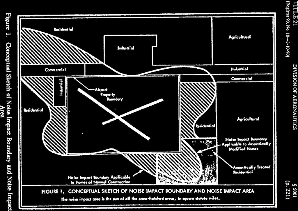
149
150
151
152
153
154

155
156

157
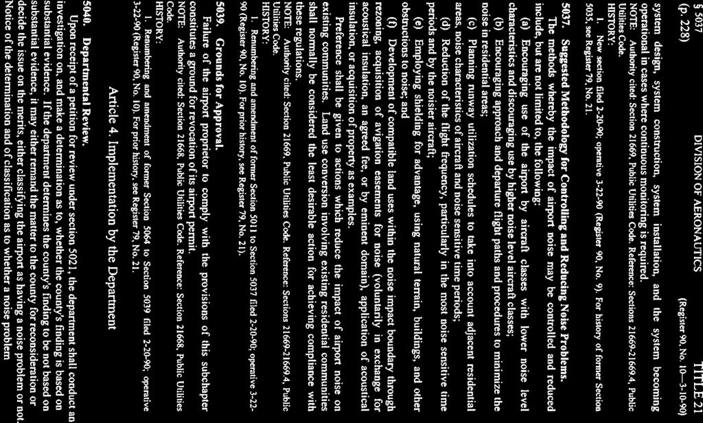
158

159

160
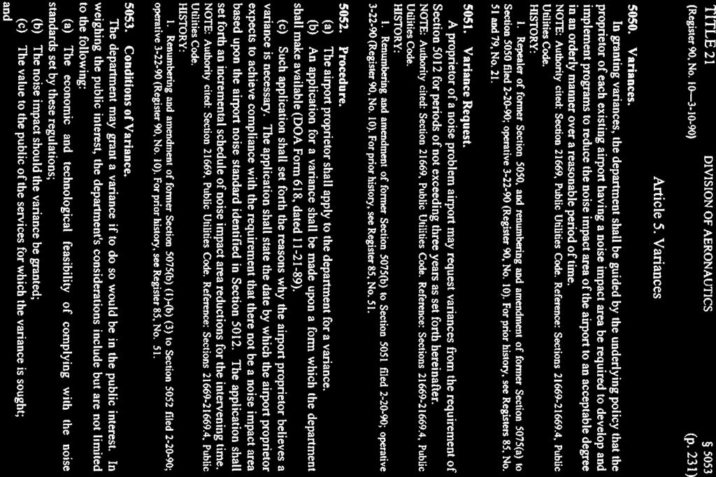
161
162
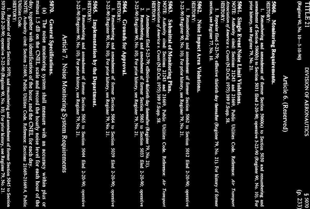
163
164
165
166
167
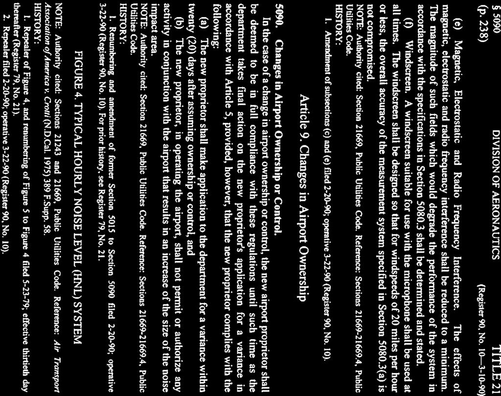
168
169


170
Airport Land Use Commission AIRPORT ENVIRONS. LAND USE PLAN for JOHN WAYNE AIRPORT
 Airport Land Use Commission AIRPORT ENVIRONS LAND USE PLAN for JOHN WAYNE AIRPORT Amended: April 17, 2008 AIRPORT ENVIRONS LAND USE PLAN April 17, 2008 Text of Plan Adopted April 17, 1975 Marine Corps
STAFF REPORT. Airport Land Use Consistency Determination Betteravia Plaza. MEETING DATE: January 21, 2016 AGENDA ITEM: 8D
 STAFF REPORT SUBJECT: Airport Land Use Consistency Determination Betteravia Plaza MEETING DATE: AGENDA ITEM: 8D STAFF CONTACT: Andrew Orfila RECOMMENDATION: Adopt findings for the Betteravia Plaza project
APPENDIX K LAND USE. Charles M. Schulz - Sonoma County Airport Draft Environmental Impact Report July 2011 K-1
 APPENDIX K LAND USE Charles M. Schulz - Sonoma County Airport Draft Environmental Impact Report July 2011 K-1 Appendix K Land Use THIS PAGE INTENTIONALLY LEFT BLANK Charles M. Schulz - Sonoma County Airport
STAFF REPORT. Airport Land Use Plan Consistency Review: Old Town Village Mixed Use Project City of Goleta. MEETING DATE: June 18, 2015 AGENDA ITEM: 5M
 STAFF REPORT SUBJECT: Airport Land Use Plan Consistency Review: Old Town Village Mixed Use Project City of Goleta MEETING DATE: AGENDA ITEM: 5M STAFF CONTACT: Peter Imhof, Andrew Orfila RECOMMENDATION:
Notice of Extended Comment Period for an Intent to Adopt a Negative Declaration
 County of Santa Clara Department of Planning and Development Planning Office County Government Center, East Wing, 7 th Floor 70 West Hedding Street San Jose, California 95110-1705 (408) 299-5770 FAX (408)
The following criteria shall be applied within the boundaries of the AO District:
 Sec. 419 (a) Purpose AIRPORT OVERLAY DISTRICT (AO) The purpose of the Airport Overlay District is to regulate and restrict the height of structures, objects, or natural growth, regulate the locations of
Chapter Six ALP Drawings. Tacoma Narrows Airport. Master Plan Update
 Chapter Six ALP Drawings Master Plan Update The master planning process for the (Airport) has evolved through efforts in the previous chapters to analyze future aviation demand, establish airside and landside
City of Upland, California September 2014 Draft
 Cable Airport Land Use Compatibility Plan City of Upland, California September 2014 Draft Cable Airport Land Use Compatibility Plan September 2014 Draft Prepared for City of Upland, California Prepared
Flying Cloud Airport (FCM) Zoning Process: Informing a Mn/DOT Path Forward
 Zoning Process: Informing a Mn/DOT Path Forward") : Informing a Mn/DOT Path Forward A Review of the Flying Cloud Airport (FCM) Joint Airport Zoning Board (JAZB) Process and the Draft Airport Zoning Ordinance B A RPZ RPZ A B C Zone Chad E. Leqve Director
: Informing a Mn/DOT Path Forward A Review of the Flying Cloud Airport (FCM) Joint Airport Zoning Board (JAZB) Process and the Draft Airport Zoning Ordinance B A RPZ RPZ A B C Zone Chad E. Leqve Director
Beale Air Force Base Land Use Compatibility Plan
 Beale Air Force Base Land Use Compatibility Plan Airport Land Use Commission for Sacramento, Sutter, Yolo, and Yuba Counties Sacramento Area Council of Governments Yuba County, California September 2010
at: Accessed May 4, 2011.
 3.11 SAFETY 3.11.1 Background and Methodology As with other forms of transportation, there is risk associated with aviation activities. This section focuses on risk to those on the ground near airports.
ORDINANCE NO. _2013-
 ORDINANCE NO. _2013- AN ORDINANCE OF THE TOWNSHIP OF CONEWAGO, DAUPHIN COUNTY, PENNSYLVANIA, PROVIDING FOR AIRPORT ZONING REGULATIONS WITHIN THE AIRPORT ZONING OVERLAY DISTRICT CREATED BY THIS ORDINANCE
Appendices. Merced County Airport Land Use Compatibility Plan
 Appendices Merced County Airport Land Use Compatibility Plan A P P E N D I X A Foundations of Airport Land Use Compatibility Planning INTRODUCTION This appendix outlines the policy foundations upon which
STAFF REPORT. Airport Land Use Plan Consistency Review: Santa Barbara Airport Master Plan. MEETING DATE: November 19, 2015 AGENDA ITEM: 7D
 STAFF REPORT SUBJECT: Airport Land Use Plan Consistency Review: Santa Barbara Airport Master Plan MEETING DATE: AGENDA ITEM: 7D STAFF CONTACT: Peter Imhof, Andrew Orfila RECOMMENDATION: Adopt findings
Butte County. Airport land use. compatibility plan OROVILLE MUNICIPAL, CHICO MUNICIPAL, RANCHAERO AIRPORTS PARADISE AND
 CHICO MUNICIPAL, OROVILLE MUNICIPAL, PARADISE AND RANCHAERO AIRPORTS Butte County Airport land use compatibility plan Prepared for the BUTTE COUNTY AIRPORT LAND USE COMMISSION Adopted November 15, 2017
Comparison Between Old and New ALUC Plans
 A P P E N I X H Comparison Between Old and New ALUC Plans OVERVIEW This Placer County Airport Land Use Compatibility Plan (ALUCP) sets forth land use compatibility criteria for the environs of Auburn Municipal,
AIRPORT LAND USE COMPATILIBILTY AIRPORT LAND USE COMPATIBILIITY
 CHAPTER 7 AIRPORT LAND USE COMPATILIBILTY CHAPTER 7 AIRPORT LAND USE COMPATIBILIITY 7.0 INTRODUCTION On airport aviation related development is typically compatible with aircraft operations. On airport
ARTICLE 34 AIRPORT HEIGHT COMBINING ZONE (AH) (Amended by Ordinance #295 Effective June 26, 2009)
 (Amended by Ordinance #295 Effective June 26, 2009)") ARTICLE 34 AIRPORT HEIGHT COMBINING ZONE (AH) (Amended by Ordinance #295 Effective June 26, 2009) Section 34.10 - Purpose and Intent The purpose of the Airport Height Combining Zone (AH) is to protect
ARTICLE 34 AIRPORT HEIGHT COMBINING ZONE (AH) (Amended by Ordinance #295 Effective June 26, 2009) Section 34.10 - Purpose and Intent The purpose of the Airport Height Combining Zone (AH) is to protect
Chapter 1. Introduction. Placer County Airport Land Use Compatibility Plan
 Chapter 1 Introduction Placer County Airport Land Use Compatibility Plan 1 Introduction OVERVIEW This Placer County Airport Land Use Compatibility Plan (ALUCP) contains the individual Compatibility Plan
Consideration will be given to other methods of compliance which may be presented to the Authority.
 Advisory Circular AC 139-10 Revision 1 Control of Obstacles 27 April 2007 General Civil Aviation Authority advisory circulars (AC) contain information about standards, practices and procedures that the
CHAPTER 6 NOISE EXPOSURE
 CHAPTER 6 NOISE EXPOSURE FAA requires that the NEM submitted for review represent the aircraft noise exposure for the year of submittal (in this case 2008) and for a future year (2013 for OSUA). However,
 Brown Field Municipal Airport Land Use Compatibility Plan San Diego County Regional Airport Authority Brown Field Municipal Airport Land Use Compatibility Plan Prepared for: San Diego County Regional
APPENDIX F. FAA and Orange County ALUC References
 APPENDIX F FAA and Orange County ALUC References Mail Processing Center Federal Aviation Administration Southwest Regional Office Obstruction Evaluation Group 2601 Meacham Boulevard Fort Worth, TX 76193
FRENCH VALLEY AIRPORT (F70) Sky Canyon Dr. Murrieta, CA. Phone: Riverside FAA FSDO Complaint Line: (951)
 Sky Canyon Dr. Murrieta, CA. Phone: Riverside FAA FSDO Complaint Line: (951)") FRENCH VALLEY AIRPORT (F70) 37600 Sky Canyon Dr. Murrieta, CA Phone: 951-600-7297 Riverside FAA FSDO Complaint Line: (951) 276-6701 Visit the F70 website for additional information regarding the airport
FRENCH VALLEY AIRPORT (F70) 37600 Sky Canyon Dr. Murrieta, CA Phone: 951-600-7297 Riverside FAA FSDO Complaint Line: (951) 276-6701 Visit the F70 website for additional information regarding the airport
AIR TRANSPORTATION ELEMENT
 AIR TRANSPORTATION ELEMENT Sonoma County Permit and Resource Management Department 2550 Ventura Avenue Santa Rosa, CA 95403 Adopted by Resolution No. 08-0808 of the Sonoma County Board of Supervisors September
Appendix C AIRPORT LAYOUT PLANS
 Appendix C AIRPORT LAYOUT PLANS Appendix C AIRPORT LAYOUT PLANS Airport Master Plan Santa Barbara Airport As part of this Airport Master Plan, the Federal Aviation Administration (FAA) requires the development
APPENDIX D FEDERAL AVIATION REGULATIONS, PART 77
 APPENDIX D FEDERAL AVIATION REGULATIONS, PART 77 Subparts A through C PART 77 - OBJECTS AFFECTING NAVIGABLE AIRSPACE Subpart A General 77.1 Scope. 77.2 Definition of terms. 77.3 Standards. 77.5 Kinds of
Memorandum. Federal Aviation Administration. Date: June 19, Richard Doucette, Environmental Protection Specialist. From: To:
 Federal Aviation Administration Memorandum Date: June 19, 2008 From: To: Subject: Richard Doucette, Environmental Protection Specialist LaVerne Reid, Airports Division Manager John Donnelly, Regional Counsel
THE BURBANK-GLENDALE-PASADENA AIRPORT AUTHORITY S UPDATE REGARDING ITS NOISE IMPACT AREA REDUCTION PLAN AND ITS PART 161 STUDY SECOND QUARTER 2015
 THE BURBANK-GLENDALE-PASADENA AIRPORT AUTHORITY S UPDATE REGARDING ITS NOISE IMPACT AREA REDUCTION PLAN AND ITS PART 161 STUDY SECOND QUARTER 2015 Pursuant to the California Department of Transportation
THE BURBANK-GLENDALE-PASADENA AIRPORT AUTHORITY S UPDATE REGARDING ITS NOISE IMPACT AREA REDUCTION PLAN AND ITS PART 161 STUDY SECOND QUARTER 2017
 THE BURBANK-GLENDALE-PASADENA AIRPORT AUTHORITY S UPDATE REGARDING ITS NOISE IMPACT AREA REDUCTION PLAN AND ITS PART 161 STUDY SECOND QUARTER 2017 Pursuant to the California Department of Transportation
AIRSPACE PROTECTION. Guidance and considerations for development in the vicinity of Ohio s airports and heliports
 AIRSPACE PROTECTION Guidance and considerations for development in the vicinity of Ohio s airports and heliports UPDATED SPRING 2018 AIRSPACE PROTECTION When construction is proposed near public use airports
LAX Community Noise Roundtable. Aircraft Noise 101. November 12, 2014
 LAX Community Noise Roundtable Aircraft Noise 101 November 12, 2014 Overview Roles and Responsibilities for Aircraft Noise Relevant Federal Regulations Relevant California Regulations Aircraft Noise Metrics
Reliever Airports: NOISE ABATEMENT PLAN Flying Cloud Airport (FCM)
") Reliever Airports: NOISE ABATEMENT PLAN Flying Cloud Airport (FCM) INTRODUCTION The Noise Abatement Plan (FCM Plan) for the Flying Cloud Airport has been prepared in recognition of the need to make the
Reliever Airports: NOISE ABATEMENT PLAN Flying Cloud Airport (FCM) INTRODUCTION The Noise Abatement Plan (FCM Plan) for the Flying Cloud Airport has been prepared in recognition of the need to make the
Part 150 and Part 161: Purpose, Elements, and Process
 Part 150 and Part 161: Purpose, Elements, and Process Presentation to: Noise Compatibility Committee January 29, 2015 Ted Baldwin Part 150, Airport Noise Compatibility Planning FAA created in response
Article 11 Airport District
 Cities County A Article 11 Article 11 Section 11.01 Intent (a) A. The A is established to provide for uses, activities, facilities, and structures necessary for the safe and efficient operation of aircraft
THE BURBANK-GLENDALE-PASADENA AIRPORT AUTHORITY S UPDATE REGARDING ITS NOISE IMPACT AREA REDUCTION PLAN AND ITS PART 161 STUDY FIRST QUARTER 2015
 THE BURBANK-GLENDALE-PASADENA AIRPORT AUTHORITY S UPDATE REGARDING ITS NOISE IMPACT AREA REDUCTION PLAN AND ITS PART 161 STUDY FIRST QUARTER 2015 Pursuant to the California Department of Transportation
WELCOME! FORT LAUDERDALE-HOLLYWOOD INTERNATIONAL AIRPORT 14 CFR PART 150 NOISE AND LAND USE COMPATIBILITY STUDY
 WELCOME! FORT LAUDERDALE-HOLLYWOOD INTERNATIONAL AIRPORT 14 CFR PART 150 NOISE AND LAND USE COMPATIBILITY STUDY Public Information Workshop November 2017 1 14 CFR Part 150 Overview Establishes the methodology
Background Data: Blue Canyon Airport and Environs
 5 Background Data: and Environs INTRODUCTION serves as an important emergency landing field amid mountainous terrain. The airport has existed on the site since the 1930s or 40s. The facility was operated
RULES OF TENNESSEE DEPARTMENT OF TRANSPORTATION AERONAUTICS DIVISION CHAPTER LICENSING AND REGISTRATION OF AIRPORTS TABLE OF CONTENTS
 RULES OF TENNESSEE DEPARTMENT OF TRANSPORTATION AERONAUTICS DIVISION CHAPTER 1680-1-2 LICENSING AND REGISTRATION OF AIRPORTS TABLE OF CONTENTS 1680-1-2-.01 Purpose 1680-1-2-.06 Repealed 1680-1-2-.02 Definitions
Overview ICAO Standards and Recommended Practices for Aerodrome Safeguarding
 Overview ICAO Standards and Recommended Practices for Aerodrome Safeguarding References The Convention on International Civil Aviation (Chicago Convention) ICAO SARPS Annex 14 Vol. I, 7 th Edition, July
Airport Land Use Compatibility Plan (ALUCP) Update. Public Information Meeting #4 June 8 & 9, 2016
 Update. Public Information Meeting #4 June 8 & 9, 2016") Airport Land Use Compatibility Plan (ALUCP) Update Public Information Meeting #4 June 8 & 9, 2016 Agenda 1. Study Process 2. Noise Complaint Patterns 3. Proposed Overflight Areas (AOA) 4. Proposed Land
Airport Land Use Compatibility Plan (ALUCP) Update Public Information Meeting #4 June 8 & 9, 2016 Agenda 1. Study Process 2. Noise Complaint Patterns 3. Proposed Overflight Areas (AOA) 4. Proposed Land
ADVISORY CIRCULAR ON LAND USE AND ENVIRONMENTAL MANAGEMENT IN THE VICINITY OF AERODROMES
 Page 1 of 9 1.0 PURPOSE 1. The purpose of this Advisory Circular (AC) is to provide guidance on land use practices and activities in the vicinity of aerodromes. 2.0 REFERENCE 2.1 The Civil Aviation (Aerodromes)
Learning More About: Protecting and Evaluating Airspace for Airports
 Learning More About: Protecting and Evaluating Airspace for Airports Introduction Tall structures, smoke, and Tall Structures rising terrain are just a few conditions that can create hazardous conditions
Aeronautical Studies (Safety Risk Assessment)
") Advisory Circular Aeronautical Studies (Safety Risk Assessment) FIRST EDITION GEORGIAN CIVIL AVIATION AGENCY Chapter LIST OF EFFECTIVE PAGES Pages Amend. No Date of Issue List of effective pages 2 0.00
Advisory Circular Aeronautical Studies (Safety Risk Assessment) FIRST EDITION GEORGIAN CIVIL AVIATION AGENCY Chapter LIST OF EFFECTIVE PAGES Pages Amend. No Date of Issue List of effective pages 2 0.00
St. Paul Downtown Airport (STP)
") Reliever Airports: NOISE ABATEMENT PLAN St. Paul Downtown Airport (STP) 1 INTRODUCTION The noise abatement plan for the St. Paul Downtown Airport (STP) was prepared in recognition of the need to make the
Reliever Airports: NOISE ABATEMENT PLAN St. Paul Downtown Airport (STP) 1 INTRODUCTION The noise abatement plan for the St. Paul Downtown Airport (STP) was prepared in recognition of the need to make the
AIRPORT ZONING REGULATIONS for the City of McPherson, Kansas
 AIRPORT ZONING REGULATIONS for the City of McPherson, Kansas ARTICLE 1. TITLE, PURPOSE, AUTHORITY AND JURISDICTION 100 Title. These regulations, including the McPherson Airport Zoning Map made a part hereof,
-NOTE: NOT TO BE USED FOR NAVIGATION PURPOSES-
 APPENDIX 1-B INSTRUMENT APPROACH PROCEDURES March 2010 SKYHAVEN AIRPORT -NOTE: NOT TO BE USED FOR NAVIGATION PURPOSES- -NOTE: NOT TO BE USED FOR NAVIGATION PURPOSES- -NOTE: NOT TO BE USED FOR NAVIGATION
NOTICE TO PROPOSED CITY PERMITS: ZONING HEIGHT RESTRICTIONS/APPROVAL PROCESS
 NOTICE TO PROPOSED CITY PERMITS: ZONING HEIGHT RESTRICTIONS/APPROVAL PROCESS Dear Prospective Permittee: The City of St Petersburg (City) issues permits for construction projects based on local and state
PLANNING AND ZONING MEETING. March 20, 2019 AGENDA. 1. Review Minutes. 1
 PLANNING AND ZONING MEETING March 20, 2019 AGENDA 1. Review Minutes. 1 2. Appointments A. Land Use Map Discussion Horrocks Engineers.. 2 B. Airport Protection Ordinance. 3-8 3. Other Business 4. Adjourn
Contents. Page 1 of 11 / Draft Chapter 142 Version CHAPTER AIRPORT ZONING... 2 ARTICLE I. - IN GENERAL... 2
 Contents CHAPTER 142 - AIRPORT ZONING... 2 ARTICLE I. - IN GENERAL... 2 Sec 142-1. - Applicability... 2 Secs. 142-2 142-35. - Reserved.... 3 ARTICLE II. - ST. PETERSBURG-CLEARWATER INTERNATIONAL AIRPORT
Boise Municipal Code. Chapter DEFINITIONS
 Chapter 12-03 DEFINITIONS Sections: 12-03-01 ADMINISTRATOR 12-03-02 AIRPORT DESIGNATIONS 12-03-03 AIRPORT HAZARD 12-03-04 AIRPORT HEIGHT LIMITATIONS 12-03-05 AIRPORT REFERENCE POINT 12-03-06 AIRPORT INSTRUMENT
Chapter AIRPORT ZONING
 Chapter 142 - AIRPORT ZONING ARTICLE I. - IN GENERAL Sec 142-1 Applicability The airport protection zoning regulations contained in this Chapter shall be applicable to the areas identified in Exhibit A,
Part 77 CAA Consolidation 1 April 2014 Objects and Activities Affecting Navigable Airspace
 Part 77 CAA Consolidation 1 April 2014 Objects and Activities Affecting Navigable Airspace Published by the Civil Aviation Authority of New Zealand DESCRIPTION Part 77 prescribes rules for persons proposing
Control of Cranes and Other Temporary Obstacles
 United Kingdom Overseas Territories Aviation Circular OTAC 139-27 140-11 171-8 172-11 178-10 Control of Cranes and Other Temporary Obstacles Issue 1 1 June 2018 Effective on issue GENERAL Overseas Territories
County of San Bernardino Film Permit Information
 County of San Bernardino Film Permit Information Dear Permit Applicant: The following is information about the County of San Bernardino Filming Permit Application. Enclosed you will also find a Filmmakers
Planning Challenges and Solutions
 2007 AirTAP Fall Forum Planning Challenges and Solutions Matt Romanik Past Interim Airport Manager, Grand Rapids Itaska County Airport Gina Mitchell Planner, Bolton & Menk Inc. Kathy Vesely Zoning Coordinator
CITY OF BELLFLOWER ORDINANCE NO. 1320
 CITY OF BELLFLOWER ORDINANCE NO. 1320 AN ORDINANCE APPROVING ZONING ORDINANCE TEXT AMENDMENT CASE NO. ZOTA 16-04 AMENDING SECTIONS 17.44.235, 17.88.050, AND 17.88.100 OF TITLE 17 OF THE BELLFLOWER MUNICIPAL
TANZANIA CIVIL AVIATION AUTHORITY AIR NAVIGATION SERVICES INSPECTORATE. Title: CONSTRUCTION OF VISUAL AND INSTRUMENT FLIGHT PROCEDURES
 Page 1 of 8 1. PURPOSE 1.1. This Advisory Circular provides guidance to personnel involved in construction of instrument and visual flight procedures for publication in the Aeronautical Information Publication.
Airport Protection Area
 APPENDIX H Airport Protection Area The Airport Land Use Commission of Alameda County Hayward, California Resolution 93-01 At a meeting held January 13, 1993 Introduced by Commissioner Maestas Seconded
Flying Cloud Airport Joint Airport Zoning Board. 27 February 2018 Public Hearing #1 Overview of Proposed Airport Zoning Ordinance
 Flying Cloud Airport Joint Airport Zoning Board 27 February 2018 Public Hearing #1 Overview of Proposed Airport Zoning Ordinance Presentation Agenda Purpose & Goals Review of FCM Zoning Historical Timeline
DRAFT MASTER PLAN UPDATE
 DRAFT MASTER PLAN UPDATE CHAPTER VI: AIRPORT LAYOUT PLAN NARRATIVE DRAFT REPORT APRIL 2017 PREPARED BY: Table of Contents WESTCHESTER COUNTY AIRPORT 6 AIRPORT LAYOUT PLAN NARRATIVE REPORT... 6-1 6.1 AGIS
ORDINANCE NO
 ORDINANCE NO. 2002-123 ORDINANCE OF THE CITY COUNCIL OF THE CITY OF LAGUNA NIGUEL, CALIFORNIA, ADOPTING MODEL GLIDER FLYING REGULATIONS FOR LILLY SHAPELL PARK The City Council of the City of Laguna Niguel
SITE ELEVATION AMSL...Ground Elevation in feet AMSL STRUCTURE HEIGHT...Height Above Ground Level OVERALL HEIGHT AMSL...Total Overall Height AMSL
 ******************************************** * Federal Airways & Airspace * * Summary Report * ******************************************** File: User Assigned File Name Latitude: NAD83 Coordinate Longitude:
ORDINANCE NO. JACKSON TOWNSHIP, CAMBRIA COUNTY
 ORDINANCE NO. JACKSON TOWNSHIP, CAMBRIA COUNTY AN ORDINANCE OF THE TOWNSHIP OF JACKSON AMENDING SECTIONS OF THE JACKSON TOWNSHIP ZONING ORDINANCE AS FOLLOWS: PROVIDING NEW DEFINITIONS OF CAMPGROUNDS, CAMPSITE,
TITLE 16. DEPARTMENT OF TRANSPORTATION CHAPTER 62. AIR SAFETY AND ZONING
 NOTE: This is a courtesy copy of this rule. The official version can be found in the New Jersey Administrative Code. Should there be any discrepancies between this text and the official version, the official
NEGATIVE DECLARATION. NAME OF PROJECT: Fresno County Airport Land Use Compatibility Plan (ALUCP)
") Negative Declaration Fresno County ALUCP December 3, 2018 NEGATIVE DECLARATION The Fresno County Airport Land Use Commission (ALUC) has reviewed the proposed project described below to determine whether
Negative Declaration Fresno County ALUCP December 3, 2018 NEGATIVE DECLARATION The Fresno County Airport Land Use Commission (ALUC) has reviewed the proposed project described below to determine whether
b. Minimum Site Area. Recreational vehicle parks shall be located on a parcel of land not less than 3 acres in area.
 6450 RECREATIONAL VEHICLE PARK REGULATIONS 6450 TITLE AND PURPOSE. The provisions of Section 6450 through 6499, inclusive, shall be known as the Recreational Vehicle Park Regulations. The purpose of these
COMMISSION OF THE EUROPEAN COMMUNITIES. Draft. COMMISSION REGULATION (EU) No /2010
 No /2010") COMMISSION OF THE EUROPEAN COMMUNITIES Brussels, XXX Draft COMMISSION REGULATION (EU) No /2010 of [ ] on safety oversight in air traffic management and air navigation services (Text with EEA relevance)
COMMISSION OF THE EUROPEAN COMMUNITIES Brussels, XXX Draft COMMISSION REGULATION (EU) No /2010 of [ ] on safety oversight in air traffic management and air navigation services (Text with EEA relevance)
Control of Airport- and Aircraft-Related Noise in the United States
 12 TRANSPORTATION RESEARCH RECORD 1143 Control of Airport- and Aircraft-Related Noise in the United States CLIFFORD R. BRAGDON Regulatory control of aircraft noise in the airport community environment
OVERSEAS TERRITORIES AVIATION REQUIREMENTS (OTARs)
") OVERSEAS TERRITORIES AVIATION REQUIREMENTS (OTARs) Part 171 AERONAUTICAL TELECOMMUNICATION SERVICES Published by Air Safety Support International Ltd Air Safety Support International Limited 2005 First
OVERSEAS TERRITORIES AVIATION REQUIREMENTS (OTARs) Part 171 AERONAUTICAL TELECOMMUNICATION SERVICES Published by Air Safety Support International Ltd Air Safety Support International Limited 2005 First
COMMISSION IMPLEMENTING REGULATION (EU)
") 18.10.2011 Official Journal of the European Union L 271/15 COMMISSION IMPLEMENTING REGULATION (EU) No 1034/2011 of 17 October 2011 on safety oversight in air traffic management and air navigation services
18.10.2011 Official Journal of the European Union L 271/15 COMMISSION IMPLEMENTING REGULATION (EU) No 1034/2011 of 17 October 2011 on safety oversight in air traffic management and air navigation services
PLAN Anoka County - Blaine Airport
 Reliever Airports: NOISE ABATEMENT PLAN Anoka County - Blaine Airport INTRODUCTION The noise abatement plan for the Anoka County-Blaine Airport was prepared in recognition of the need to make the airport
COMPREHENSIVE LAND USE PLAN SANTA CLARA COUNTY PALO ALTO AIRPORT
 COMPREHENSIVE LAND USE PLAN SANTA CLARA COUNTY PALO ALTO AIRPORT ADOPTED By the SANTA CLARA COUNTY AIRPORT LAND USE COMMISSION San Jose, California November 19, 2008 Prepared by Walter B. Windus, PE Aviation
D1 January 8, 2014 Public Hearing APPLICANT: HUNT CLUB FARM
 D1 January 8, 2014 Public Hearing APPLICANT: HUNT CLUB FARM PROPERTY OWNER: HUNT CLUB A-1- A, LLC. STAFF PLANNER: Kevin Kemp REQUEST: Modification of a Conditional Use Permit approved by the City Council
** DETERMINATION OF NO HAZARD TO AIR NAVIGATION **
 Mail Processing Center Federal Aviation Administration Southwest Regional Office Obstruction Evaluation Group 2601 Meacham Boulevard Fort Worth, TX 76137 Issued Date: 05/16/2011 Aeronautical Study No.
Welcome to Public Information Workshop 1. San Francisco International Airport FAR Part 150 Study Update Noise Exposure Map Report
 Welcome to Public Information Workshop 1 Chetcuti Room, City of Milbrae 450 Poplar Avenue Milbrae, California 94030 Wednesday, June 4, 2014 5:45 p.m. to 6:45 p.m. PDT The FAA typically uses the airport
APPENDIX F LAND USE PLANNING FOR AIRPORTS AND POCATELLO REGIONAL AIRPORT LAND USE COMPLIANCE
 APPENDIX F LAND USE PLANNING FOR AIRPORTS AND POCATELLO REGIONAL AIRPORT LAND USE COMPLIANCE Pocatello Regional Airport Airport Master Plan APPENDIX F LAND USE PLANNING FOR AIRPORT AND POCATELLO REGIONAL
AVIATION PLANNING AND DEVELOPMENT Oakland International Airport 530 Water Street Oakland, CA 94607
 AVIATION PLANNING AND DEVELOPMENT Oakland International Airport 530 Water Street When Do I Need to File an FAA Form 7460-1? Objects Affecting Navigable Airspace (14CFR77) June 2013 Background The Federal
Appendix B CLEAR ZONES AND ACCIDENT POTENTIAL ZONES
 Appendix B CLEAR ZONES AND ACCIDENT POTENTIAL ZONES 2007 AICUZ Study B-1 THIS PAGE INTENTIONALLY LEFT BLANK B-2 2007 AICUZ Study CLEAR ZONES AND ACCIDENT POTENTIAL ZONES B.1 Guidelines For Accident Potential
Hearings will be held in the Shirley Huffman Auditorium in the Charles D. Cameron Public Services Building, 155 North First Avenue, Hillsboro, Oregon.
 Hearings will be held in the Shirley Huffman Auditorium in the Charles D. Cameron Public Services Building, 155 North First Avenue, Hillsboro, Oregon. On September 24, 2013, the Board of County Commissioners
Executive Summary. MASTER PLAN UPDATE Fort Collins-Loveland Municipal Airport
 Executive Summary MASTER PLAN UPDATE Fort Collins-Loveland Municipal Airport As a general aviation and commercial service airport, Fort Collins- Loveland Municipal Airport serves as an important niche
Rule Governing the Designation and Establishment of All-Terrain Vehicle Use Trails on State Land
 Rule Governing the Designation and Establishment of All-Terrain Vehicle Use Trails on State Land 1.0 Authority 1.1 This rule is promulgated pursuant to 23 V.S.A. 3506. Section 3506 (b)(4) states that an
Procedures for Approval of Master Minimum Equipment List
 Circular No. 1-009 Procedures for Approval of Master Minimum Equipment List October 3, 2000 First issue (KOKU-KU-KI-1193) April 8, 2011 Amended (KOKU-KU-KOU-1399, KOKU-KU-KI-1209) June 30, 2011 Amended
Staff Instruction. Aerial Assessment Requirements Prior to Heliport Certification
 Staff Instruction Subject: Aerial Assessment Requirements Prior to Heliport Certification Issuing Office: Standards Document No.: SI 305-001 File Classification No.: Z 5000-32 Issue No.: 01 RDIMS No.:
Sample Regulations for Water Aerodromes
 Sample Regulations for Water Aerodromes First Edition (unedited version) March 2015 Notice to users: This document is an unedited version which is made available to the public for convenience. Its content
NATIONAL AIRSPACE POLICY OF NEW ZEALAND
 NATIONAL AIRSPACE POLICY OF NEW ZEALAND APRIL 2012 FOREWORD TO NATIONAL AIRSPACE POLICY STATEMENT When the government issued Connecting New Zealand, its policy direction for transport in August 2011, one
II. Purpose and Need. 2.1 Background
 II. 2.1 Background The Metropolitan Washington Airports Authority is preparing an Environmental Assessment of potential environmental impacts associated with proposed enhancements to the Runway 4-22 and
Washington Dulles International Airport (IAD) Aircraft Noise Contour Map Update
 Aircraft Noise Contour Map Update") Washington Dulles International Airport (IAD) Aircraft Noise Contour Map Update Ultimate ASV, Runway Use and Flight Tracks 4th Working Group Briefing 8/13/18 Meeting Purpose Discuss Public Workshop input
Washington Dulles International Airport (IAD) Aircraft Noise Contour Map Update Ultimate ASV, Runway Use and Flight Tracks 4th Working Group Briefing 8/13/18 Meeting Purpose Discuss Public Workshop input
Parkland County Municipal Development Plan Amendment Acheson Industrial Area Structure Plan
 Parkland County Municipal Development Plan Amendment Acheson Industrial Area Structure Plan New Plan Acheson Industrial Area Structure Plan Amendment Parkland County Municipal Development Plan Board Reference
** DETERMINATION OF NO HAZARD TO AIR NAVIGATION **
 Mail Processing Center Federal Aviation Administration Southwest Regional Office Obstruction Evaluation Group 2601 Meacham Boulevard Fort Worth, TX 76137 Issued Date: 01/04/2012 Aeronautical Study No.
Foreign Civil Aviation Authority Certifying Statements. AGENCY: Federal Aviation Administration (FAA), DOT.
, DOT.") This document is scheduled to be published in the Federal Register on 02/22/2019 and available online at https://federalregister.gov/d/2019-02634, and on govinfo.gov [4910-13] DEPARTMENT OF TRANSPORTATION
This document is scheduled to be published in the Federal Register on 02/22/2019 and available online at https://federalregister.gov/d/2019-02634, and on govinfo.gov [4910-13] DEPARTMENT OF TRANSPORTATION
Finance and Implementation
 5 Finance and Implementation IMPLEMENTATION The previous chapters have presented discussions and plans for development of the airfield, terminal, and building areas at Sonoma County Airport. This chapter
Minimum Requirements References in National Park Service Policy
 Minimum Requirements References in National Park Service Policy 2006 NPS Management Policies Chapter 6: Wilderness Preservation and Management 6.3 Wilderness Resource Management 6.3.1 General Policy (in
SAFEGUARDING OF AERODROMES. Advice Note 1
 AIRPORT OPERATORS ASSOCIATION & GENERAL AVIATION AWARENESS COUNCIL supported by CIVIL AVIATION AUTHORITY Working in Co-operation SAFEGUARDING OF AERODROMES Advice Note 1 Safeguarding - An Overview 1. The
USE OF 3D GIS IN ANALYSIS OF AIRSPACE OBSTRUCTIONS
 USE OF 3D GIS IN ANALYSIS OF AIRSPACE OBSTRUCTIONS A project by by Samuka D. W. F19/1461/2010 Supervisor; Dr D. N. Siriba 1 Background and Problem Statement The Airports in Kenya are the main link between
According to FAA Advisory Circular 150/5060-5, Airport Capacity and Delay, the elements that affect airfield capacity include:
 4.1 INTRODUCTION The previous chapters have described the existing facilities and provided planning guidelines as well as a forecast of demand for aviation activity at North Perry Airport. The demand/capacity
ARTICLE 16 AIRPORT REGULATIONS
 ARTICLE 16 AIRPORT REGULATIONS CHAPTER A GENERAL... 3 Section 1 Purpose and Intent... 3 Section 2 Short Title and Authority... 3 Section 3 Applicability... 3 Section 4 Definitions and Acronyms... 3 CHAPTER
(i) Adopted or adapted airworthiness and environmental standards;
 Adopted or adapted airworthiness and environmental standards;") TECHNICAL ARRANGEMENT FOR THE ACCEPTANCE OF AIRWORTHINESS AND ENVIRONMENTAL APPROVAL OF CIVIL AERONAUTICAL PRODUCTS BETWEEN THE CIVIL AVIATION BUREAU, MINISTRY OF LAND, INFRASTRUCTURE AND TRANSPORT, JAPAN
TECHNICAL ARRANGEMENT FOR THE ACCEPTANCE OF AIRWORTHINESS AND ENVIRONMENTAL APPROVAL OF CIVIL AERONAUTICAL PRODUCTS BETWEEN THE CIVIL AVIATION BUREAU, MINISTRY OF LAND, INFRASTRUCTURE AND TRANSPORT, JAPAN
DRAFT GENERAL IMPLEMENTATION PLAN AND SPECIFIC IMPLEMENTATION PLAN MIDDLETON MUNICIPAL AIRPORT MOREY FIELD. Revised 12/12/03
 DRAFT GENERAL IMPLEMENTATION PLAN AND SPECIFIC IMPLEMENTATION PLAN MIDDLETON MUNICIPAL AIRPORT MOREY FIELD Revised 12/12/03 As recommended for approval by the Plan Commission General Project Description
Chapter 9 - AIRPORT SYSTEM DESIGN
 Chapter 9 - AIRPORT SYSTEM DESIGN 9.01 GENERAL This chapter discusses the development program for Dutchess County Airport to the year 2020. This airport system design is based upon the airport's existing