-NOTE: NOT TO BE USED FOR NAVIGATION PURPOSES-
|
|
|
- Annabella Morton
- 5 years ago
- Views:
Transcription
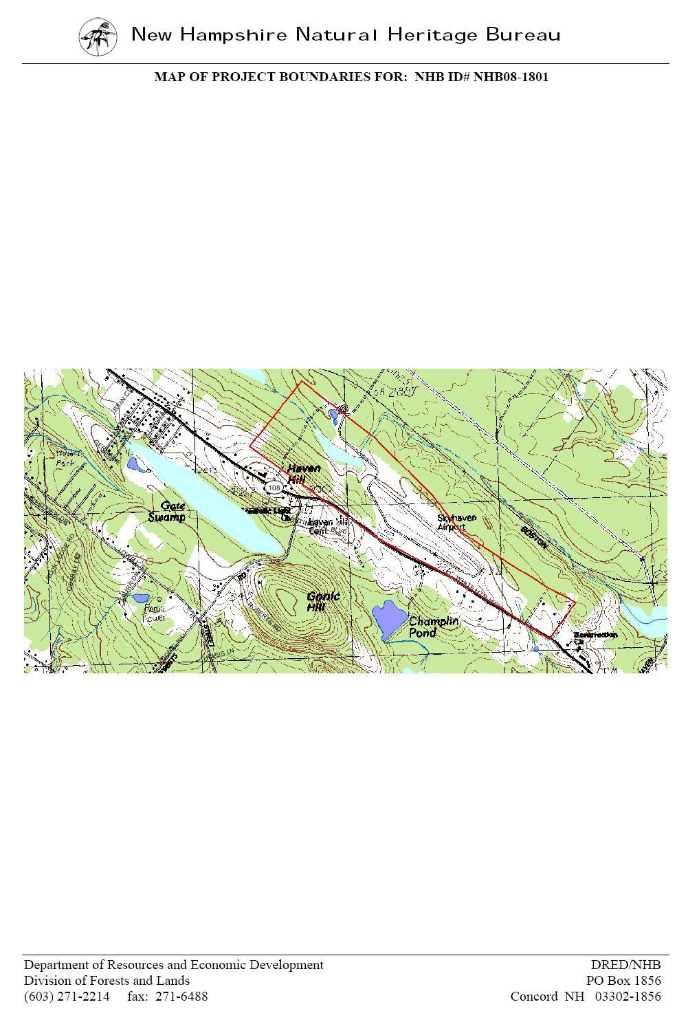
1 APPENDIX 1-B INSTRUMENT APPROACH PROCEDURES March 2010 SKYHAVEN AIRPORT -NOTE: NOT TO BE USED FOR NAVIGATION PURPOSES-

2 -NOTE: NOT TO BE USED FOR NAVIGATION PURPOSES-
3 -NOTE: NOT TO BE USED FOR NAVIGATION PURPOSES-
4 -NOTE: NOT TO BE USED FOR NAVIGATION PURPOSES-
5 -NOTE: NOT TO BE USED FOR NAVIGATION PURPOSES-
6 APPENDIX 1-C FAA AIRPORT FACILITY DIRECTORY FAA AIRPORT MASTER RECORD FORM 5010 FAA NATIONAL PLAN OF INTEGRATED AIRPORT SYSTEMS (NPIAS) FAA FLIGHT STANDARDS AIRPORT DATA SHEET

7 FAA AIRPORT FACILITY DIRECTORY -NOTE: NOT TO BE USED FOR NAVIGATION PURPOSES-
8
9
10
11
12
13 APPENDIX 1-D FAA AIRCRAFT REGISTRATION DATA STRAFFORD COUNTY, NH FAA Registry State and County Inquiry Results State: NEW HAMPSHIRE County: STRAFFORD August 2008 Number of Aircraft Single-Engine Piston Multi-Engine Piston Turboprop Jet Helicopter Other
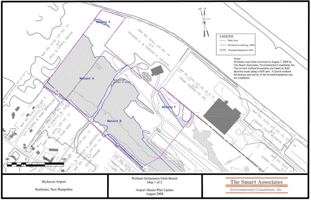
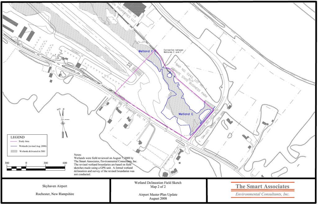
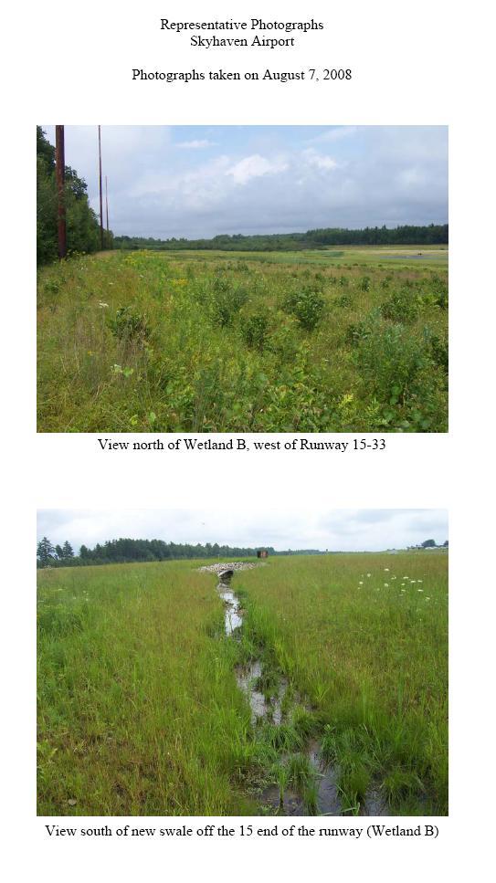
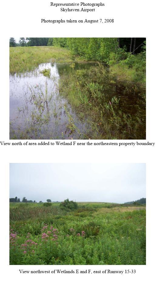
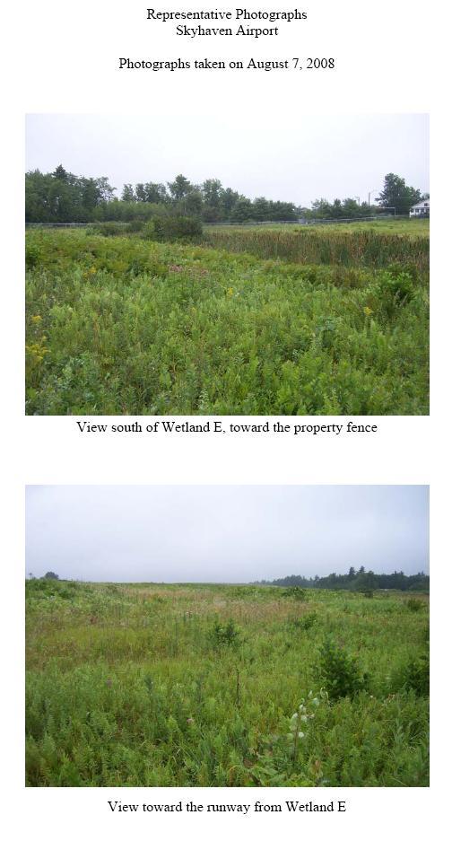
14 APPENDIX 1-E WETLANDS FIELD INVESTIGATION THE SMART ASSOCIATES AUGUST 2008
15
16
17
18
19
20
21
22
23
24
25
26
27
28
29
30
31 APPENDIX 1-F EXCERPT FROM THE CITY OF ROCHESTER ZONING ORDINANCE Chapter 42 Updated through September 2, 2008
32 42.18 Airport Zoning. (a) Definitions. As used in this section of the ordinance, unless the context otherwise requires: (1) Airport means any area of land or water, whether constructed or not, which has been approved as a site for landing and taking off of aircraft or utilized by the public as a point of arrival or departure by air, hereinafter referred to as Skyhaven Airport. (2) Airport Approach Zone means: (A) (B) For Runway 33, an area which is 1,000 feet wide at a point 200 feet from the end of the pavement and 4,000 feet wide at a point 10,200 feet from the end of the pavement, or future pavement extended. For Runway 15, an area which is 1,000 feet wide at a point 200 feet from the end of the pavement and 1,500 feet wide at a point 5,200 feet from the end of the pavement, or future pavement extended. The center line of these areas shall coincide with the center line of the landing strips extended. (3) Airport Hazard means any structure, tree, smoke, steam, dust, or other substance which obstructs the aerial approaches of Skyhaven Airport or impairs the reasonable visibility in the vicinity thereof, electrical impulses and disturbances which interfere with radio aids or communications, and lights which might result in glare in the vision of pilots or aircraft or be confused with airport lights. (4) Nonconforming Use means any structure, tree, or use of land which does not conform to a regulation prescribed in this ordinance or an amendment thereto as of the effective date of such regulations. (5) Person means any individual, firm, co-partnership, corporation, company, association, joint stock association, or body politic, and includes any trustee, receiver, assignee, or similar representative thereof. (6) Structure means any object constructed or installed by man, including such objects although regulated or licensed by other provisions of law. (7) Tree means any object of natural growth. (8) Building Restriction Lane means a line parallel to the centerline of the runway which limits the location of any permanent structure. The location of the BRL is shown and described on the Airport Layout Plan. (b) Zones. In order to carry out the purposes of this ordinance, all of the land within the boundaries of the approach zones and all of the land within a distance of twelve thousand (12,000) feet from the airport reference point shown on the Rochester Airport Approach Plan dated December 16, 1983 [attached hereto and made a part hereof], is hereby declared subject to the restrictions of the ordinance. (c) Height Limits. No structure or tree shall be erected, altered, or allowed to grow within the areas described in Section 42.18(b) hereof, above a slope ratio of thirty-four (34) feet to one (1) foot measured from the end of Runway 33 or a ratio of twenty (20) feet to one
33 (1) foot measured from the end of Runway 15 or above a slope ratio of seven (7) feet to one (1) foot measured from the side of the landing strips and the approaches, or within an ellipse formed by connecting the ends of two semi-circles having radii of 10,000 feet from points located 200 feet beyond the ends of pavement on centerline extended at each end of Runways 15/33 above a height of one hundred fifty (150) feet above the airport elevation; except that the Zoning Board of Adjustment shall have the power to grant a variance of this regulation where literal application or enforcement of the same would result in practical difficulty or unnecessary hardship and the relief granted would not be contrary to the public interest but do substantial justice and be in accordance with the spirit of the ordinance. (d) (e) (f) (g) Use Restrictions. Notwithstanding any other provisions of the Zoning Ordinance, no use may be made of the land described in Section 42.18(b) hereof in such manner as to create electrical interference with radio aids or communications between airport and aircraft, make it difficult for flyers to distinguish between airport lights and others, result in glare in the eyes of flyers using the airport, impair visibility in the vicinity of the airport by the creation and discharge of smoke, steam, dust, or other obstructions to visibility, or otherwise endanger the landing, taking off, or maneuvering of aircraft. Nonconforming Uses. The regulations prescribed in Sections 42.18(c) and 42.18(d) hereof shall not be construed to require the removal, lowering, or other change or alteration of any structure or tree not conforming to the regulations as of the effective date hereof, or otherwise interfere with the continuance of any non-conforming use. Nothing herein contained shall require any change in the construction, alteration, or intended use of any structure, the construction or alteration of which was begun prior to the effective date of this ordinance, and is diligently prosecuted and completed within two (2) years thereof. Variances. Any person desiring to erect any structure or increase the height of any structure, or permit the growth of any tree, or use his property not in accordance with the regulations prescribed in this amendment, may apply for a variance therefrom. Such variance shall be allowed where a literal application of enforcement of the regulations would result in practical difficulty or unnecessary hardship and the relief granted would not be contrary to the public interest but do substantial justice and be in accordance with the spirit of this ordinance. Permits. (1) Future Uses. No material change in violation of Sections 42.18(c) and 42.18(d) hereof shall be made in the use of land, and no structure or tree shall be erected, altered, planted, or otherwise established in violation of Sections 42.18(c) and 42.18(d) hereof, unless a permit therefore shall have been applied for and granted. Each such application shall indicate the purpose for which the permit is desired. (2) Existing Uses. Before any existing use, structure, or tree may be replaced, substantially altered, repaired or rebuilt, allowed to grow higher, or replanted, within any of the areas of land described in Section 42.18(b) hereof, a permit must be secured authorizing such replacement, change, or repair if it is in violation of Sections 42.18(c) and 42.18(d) hereof. No such permit shall be granted that would allow the establishment or creation of an airport hazard or permit a nonconforming use, structure, or tree to be made or become a greater hazard to air navigation, than it was on the effective date of this ordinance, or than it is when the application for a permit is made. Except as indicated, all
34 applications for a permit for replacement, change, or repair of existing use, structure, or tree shall be granted. (h) (i) Hazard Marking and Lighting. Any permit or variance granted under Section 42.18(f) and 42.18(g) may, if such action is deemed advisable to effectuate the purposes of this ordinance and reasonable in the circumstances, be so conditioned as to require the owner of the structure or tree in question to permit the airport owner at its own expense, to install, operate, and maintain thereon such markers and lights as may be necessary to indicate to flyers the presence of an airport hazard. Zone Map. A copy of said approach zone map shall become a part of the Zoning Map of the City of Rochester, New Hampshire. ROCHESTER, SKYHAVEN AIRPORT APPROACH PLAN Adopted by New Hampshire Aeronautics Commission April 1, 1968 Revised December 16, 1983 (1) This Airport Approach Plan, prepared under the authority of Chapter of the New Hampshire Revised Statutes Annotated, is based upon the ultimate development of a General Aviation Type Airport with runway and landing strip as follows: (A) Runway 5,400 feet by 100 feet; Landing Strip 5,800 feet by 300 feet. (2) Part 77, Federal Aviation Regulations establishes the standards used to determine the limit of height of obstructions in the vicinity of the airport. (3) The limit of height of obstructions shall be: (A) In the approach area to the landing strip for Runway 33, which is 1,000 feet wide at a point 200 feet from the end of the pavement and 4,000 feet wide at a point 10,200 feet from the end of the pavement, an inclined plane of 34:1 slope. (B) In the approach area to the landing strip for Runway 15, which is 1,000 feet wide at a point 200 feet from the end of the pavement and 1,500 feet wide at a point 5,200 feet from the end of the pavement, an inclined plane of 20:1 slope. (C) (D) (E) On the sides of the landing strip and approach areas, an inclined plane of 7:1 slope. 472 feet above sea level within the horizontal surface, which is a plane 150 feet above the established airport elevation. This plane is an ellipse formed by connecting the ends of two semicircles having radii of 10,000 feet from points located 200 feet beyond ends of pavement on centerline extended at each end of Runway 15/33. Within the conical surface, which is an inclined plane sloping upward at a 20:1 ratio extending 4,000 feet outward from the horizontal surface.
35 (4) No provision of Section (3) shall limit the height of a structure or tree to less than 30 feet above the ground upon which it is located. (5) The Airport Reference Point is located on the centerline of Runway 15/33, 2,650 feet from the southeast end of the runway and its elevation is 322 feet above sea level. NOTE: The following is for information only and is not a part of the Airport Approach Plan: (A) The building restriction line is 300 feet from the center line of the landing strip. (B) Acquisition of property rights will be necessary: (1) to remove existing obstructions; (2) to control the height of objects in those areas where the controlling inclined plane is less than 30 feet above the ground.
ORDINANCE NO. _2013-
 ORDINANCE NO. _2013- AN ORDINANCE OF THE TOWNSHIP OF CONEWAGO, DAUPHIN COUNTY, PENNSYLVANIA, PROVIDING FOR AIRPORT ZONING REGULATIONS WITHIN THE AIRPORT ZONING OVERLAY DISTRICT CREATED BY THIS ORDINANCE
AIRPORT ZONING REGULATIONS for the City of McPherson, Kansas
 AIRPORT ZONING REGULATIONS for the City of McPherson, Kansas ARTICLE 1. TITLE, PURPOSE, AUTHORITY AND JURISDICTION 100 Title. These regulations, including the McPherson Airport Zoning Map made a part hereof,
The following criteria shall be applied within the boundaries of the AO District:
 Sec. 419 (a) Purpose AIRPORT OVERLAY DISTRICT (AO) The purpose of the Airport Overlay District is to regulate and restrict the height of structures, objects, or natural growth, regulate the locations of
PLANNING AND ZONING MEETING. March 20, 2019 AGENDA. 1. Review Minutes. 1
 PLANNING AND ZONING MEETING March 20, 2019 AGENDA 1. Review Minutes. 1 2. Appointments A. Land Use Map Discussion Horrocks Engineers.. 2 B. Airport Protection Ordinance. 3-8 3. Other Business 4. Adjourn
 Page 1 of 10 ARTICLE XXXIX. HOMESTEAD GENERAL AVIATION AIRPORT ZONING* *Editor's note: Article XXXIX, 33-372--33-387, is derived from Ord. No. 69-38, 1--16, enacted July 9, 1969. Section 17 of said ordinance
Boise Municipal Code. Chapter DEFINITIONS
 Chapter 12-03 DEFINITIONS Sections: 12-03-01 ADMINISTRATOR 12-03-02 AIRPORT DESIGNATIONS 12-03-03 AIRPORT HAZARD 12-03-04 AIRPORT HEIGHT LIMITATIONS 12-03-05 AIRPORT REFERENCE POINT 12-03-06 AIRPORT INSTRUMENT
RULES OF TENNESSEE DEPARTMENT OF TRANSPORTATION AERONAUTICS DIVISION CHAPTER LICENSING AND REGISTRATION OF AIRPORTS TABLE OF CONTENTS
 RULES OF TENNESSEE DEPARTMENT OF TRANSPORTATION AERONAUTICS DIVISION CHAPTER 1680-1-2 LICENSING AND REGISTRATION OF AIRPORTS TABLE OF CONTENTS 1680-1-2-.01 Purpose 1680-1-2-.06 Repealed 1680-1-2-.02 Definitions
Article 11 Airport District
 Cities County A Article 11 Article 11 Section 11.01 Intent (a) A. The A is established to provide for uses, activities, facilities, and structures necessary for the safe and efficient operation of aircraft
Chapter AIRPORT ZONING
 Chapter 142 - AIRPORT ZONING ARTICLE I. - IN GENERAL Sec 142-1 Applicability The airport protection zoning regulations contained in this Chapter shall be applicable to the areas identified in Exhibit A,
Contents. Page 1 of 11 / Draft Chapter 142 Version CHAPTER AIRPORT ZONING... 2 ARTICLE I. - IN GENERAL... 2
 Contents CHAPTER 142 - AIRPORT ZONING... 2 ARTICLE I. - IN GENERAL... 2 Sec 142-1. - Applicability... 2 Secs. 142-2 142-35. - Reserved.... 3 ARTICLE II. - ST. PETERSBURG-CLEARWATER INTERNATIONAL AIRPORT
Flying Cloud Airport (FCM) Zoning Process: Informing a Mn/DOT Path Forward
 Zoning Process: Informing a Mn/DOT Path Forward") : Informing a Mn/DOT Path Forward A Review of the Flying Cloud Airport (FCM) Joint Airport Zoning Board (JAZB) Process and the Draft Airport Zoning Ordinance B A RPZ RPZ A B C Zone Chad E. Leqve Director
: Informing a Mn/DOT Path Forward A Review of the Flying Cloud Airport (FCM) Joint Airport Zoning Board (JAZB) Process and the Draft Airport Zoning Ordinance B A RPZ RPZ A B C Zone Chad E. Leqve Director
ARTICLE 34 AIRPORT HEIGHT COMBINING ZONE (AH) (Amended by Ordinance #295 Effective June 26, 2009)
 (Amended by Ordinance #295 Effective June 26, 2009)") ARTICLE 34 AIRPORT HEIGHT COMBINING ZONE (AH) (Amended by Ordinance #295 Effective June 26, 2009) Section 34.10 - Purpose and Intent The purpose of the Airport Height Combining Zone (AH) is to protect
ARTICLE 34 AIRPORT HEIGHT COMBINING ZONE (AH) (Amended by Ordinance #295 Effective June 26, 2009) Section 34.10 - Purpose and Intent The purpose of the Airport Height Combining Zone (AH) is to protect
TITLE 16. DEPARTMENT OF TRANSPORTATION CHAPTER 62. AIR SAFETY AND ZONING
 NOTE: This is a courtesy copy of this rule. The official version can be found in the New Jersey Administrative Code. Should there be any discrepancies between this text and the official version, the official
PART III CODE OF ORDINANCES Chapter 33 ZONING
 ARTICLE XL. - KENDALL TAMIAMI EXECUTIVE AIRPORT ZONING Sec. 33-388. - Short title. Sec. 33-389. - Provisions hereof established as minimum standards governing zoning. Sec. 33-390. - Definitions. Sec. 33-391.
Transportation Chapter ALABAMA DEPARTMENT OF TRANSPORTATION ADMINISTRATIVE CODE CHAPTER DEFINITIONS TABLE OF CONTENTS
 Transportation Chapter 450-9-2 ALABAMA DEPARTMENT OF TRANSPORTATION ADMINISTRATIVE CODE CHAPTER 450-9-2 DEFINITIONS TABLE OF CONTENTS 450-9-2-.01 Definitions 450-9-2-.01 Definitions. For the purpose of
Planning Challenges and Solutions
 2007 AirTAP Fall Forum Planning Challenges and Solutions Matt Romanik Past Interim Airport Manager, Grand Rapids Itaska County Airport Gina Mitchell Planner, Bolton & Menk Inc. Kathy Vesely Zoning Coordinator
APPENDIX D FEDERAL AVIATION REGULATIONS, PART 77
 APPENDIX D FEDERAL AVIATION REGULATIONS, PART 77 Subparts A through C PART 77 - OBJECTS AFFECTING NAVIGABLE AIRSPACE Subpart A General 77.1 Scope. 77.2 Definition of terms. 77.3 Standards. 77.5 Kinds of
Appendix C AIRPORT LAYOUT PLANS
 Appendix C AIRPORT LAYOUT PLANS Appendix C AIRPORT LAYOUT PLANS Airport Master Plan Santa Barbara Airport As part of this Airport Master Plan, the Federal Aviation Administration (FAA) requires the development
Airport Zoning Regulations
 Airport Zoning Regulations Tampa International Airport Tampa Executive Airport Peter O. Knight Airport Plant City Airport Hillsborough County Aviation Authority June 1, 2017 TABLE OF CONTENTS Page Section
Overview ICAO Standards and Recommended Practices for Aerodrome Safeguarding
 Overview ICAO Standards and Recommended Practices for Aerodrome Safeguarding References The Convention on International Civil Aviation (Chicago Convention) ICAO SARPS Annex 14 Vol. I, 7 th Edition, July
AIRSPACE PROTECTION. Guidance and considerations for development in the vicinity of Ohio s airports and heliports
 AIRSPACE PROTECTION Guidance and considerations for development in the vicinity of Ohio s airports and heliports UPDATED SPRING 2018 AIRSPACE PROTECTION When construction is proposed near public use airports
Mapleton Municipal Airport, Mapleton, Iowa Monona County, Iowa
 Monona County Ordinance No. 53 Chapter 300(b) Airport Land Use and Height Overlay Zoning Ordinance Mapleton Municipal Airport, Mapleton, Iowa Monona County, Iowa Table of Contents Section 1. Introduction
CHAPTER 61 SHEBOYGAN COUNTY MEMORIAL AIRPORT
 61.01 OPERATION OF AIRPORT 61.02 DEFINITION OF WORDS AND PHRASES 61.03 AIRPORT OPERATION POLICIES 61.04 UTILITIES 61.05 ENTRANCES 61.06 SPECIAL VARIANCE 61.07 ENFORCEMENT 61.08 PENALTY 61.09 MULTIPLE OWNERSHIP
SITE ELEVATION AMSL...Ground Elevation in feet AMSL STRUCTURE HEIGHT...Height Above Ground Level OVERALL HEIGHT AMSL...Total Overall Height AMSL
 ******************************************** * Federal Airways & Airspace * * Summary Report * ******************************************** File: User Assigned File Name Latitude: NAD83 Coordinate Longitude:
Civil Aviation Rules, 2052 (1996)
") Civil Aviation Rules, 2052 (1996) Date of Publication in Nepal Gazette Amendment: 2052.9.24 (8 Jan. 1996) Civil Aviation (First Amendment) Rules, 2058 2058.4.32 (16 Aug. 2001) Government of Nepal has made
Civil Aviation Rules, 2052 (1996) Date of Publication in Nepal Gazette Amendment: 2052.9.24 (8 Jan. 1996) Civil Aviation (First Amendment) Rules, 2058 2058.4.32 (16 Aug. 2001) Government of Nepal has made
TITLE 20 AERONAUTICS
 TITLE 20 AERONAUTICS CHAPTERS 1 General Provisions ( 101) 2 General Powers of the Secretary; National Preemption ( 201-202) 3 Organization of Civil Aviation Authority and Powers and Duties of the Secretary
Flying Cloud Airport Joint Airport Zoning Board. 27 February 2018 Public Hearing #1 Overview of Proposed Airport Zoning Ordinance
 Flying Cloud Airport Joint Airport Zoning Board 27 February 2018 Public Hearing #1 Overview of Proposed Airport Zoning Ordinance Presentation Agenda Purpose & Goals Review of FCM Zoning Historical Timeline
ARTICLE III: LAND USE DISTRICTS 385 PRIVATE USE AIRPORT OVERLAY DISTRICT
 ARTICLE III: LAND USE DISTRICTS 385 PRIVATE USE AIRPORT OVERLAY DISTRICT III 265 385 PRIVATE USE AIRPORT OVERLAY DISTRICT 385 1 Purpose The purpose of the Private Use Airport Overlay District is to recognize
ARTICLE 16 AIRPORT REGULATIONS
 ARTICLE 16 AIRPORT REGULATIONS CHAPTER A GENERAL... 3 Section 1 Purpose and Intent... 3 Section 2 Short Title and Authority... 3 Section 3 Applicability... 3 Section 4 Definitions and Acronyms... 3 CHAPTER
Consideration will be given to other methods of compliance which may be presented to the Authority.
 Advisory Circular AC 139-10 Revision 1 Control of Obstacles 27 April 2007 General Civil Aviation Authority advisory circulars (AC) contain information about standards, practices and procedures that the
Democratic Socialist Republic of Sri Lanka. Implementing Standards (Issued under Sec. 120, Civil Aviation Act No. 14 of 2010)
") Democratic Socialist Republic of Sri Lanka Civil Aviation Authority of Sri Lanka Implementing Standards (Issued under Sec. 120, Civil Aviation Act No. 14 of 2010) Title: Requirements for Operation of Pilotless
Democratic Socialist Republic of Sri Lanka Civil Aviation Authority of Sri Lanka Implementing Standards (Issued under Sec. 120, Civil Aviation Act No. 14 of 2010) Title: Requirements for Operation of Pilotless
Chapter Six ALP Drawings. Tacoma Narrows Airport. Master Plan Update
 Chapter Six ALP Drawings Master Plan Update The master planning process for the (Airport) has evolved through efforts in the previous chapters to analyze future aviation demand, establish airside and landside
ORDINANCE #29 OSCEOLA MUNICIPAL AIRPORT LAND USE AND HEIGHT OVERLAY ZONING ORDINANCE
 Section 1-Title ORDINANCE #29 OSCEOLA MUNICIPAL AIRPORT LAND USE AND HEIGHT OVERLAY ZONING ORDINANCE This Ordinance shall be known and may be cited as THE OSCEOLA MUNICIPAL AIRPORT LAND USE & HEIGHT OVERLAY
East Midlands Airport 2018 Aerodrome Manual
 East Midlands Airport 2018 Aerodrome Manual Version 1.0 Not Valid after 31 st December 2018 Department Operations Document Owner Operations Director (Accountable Manager) Document Administrator Ops Development
Installation of Communication, Navigation, Radio and Radar Equipment.
 GOVERNMENT OF INDIA OFFICE OF DIRECTOR GENERAL OF CIVIL AVIATION TECHNICAL CENTRE, OPP SAFDARJANG AIRPORT, NEW DELHI CIVIL AVIATION REQUIREMENTS SERIES R PART II ISSUE IV, 4 TH SEPTEMBER 2017 EFFECTIVE:
related to temporary banners, flags, A-frame signs, and other temporary sign devices for commercial advertising. (Lee Plemel,
 STAFF REPORT Report To: Board of Supervisors Meeting Date: May 3, 2018 Staff Contact: Lee Plemel, Community Development Director Agenda Title: For Possible Action: To provide direction to staff regarding
The Academy of Model Aeronautics has a long and successful history in advocating for the flying privileges of the aeromodeling community.
 FAA RULE: REGISTRATION AND MARKING REQUIREMENTS FOR SMALL UNMANNED AIRCRAFT UPDATE 2012 FAA Modernization and Reform Act The Academy of Model Aeronautics has a long and successful history in advocating
Supplement No. 17 published with Gazette No. 22 dated 25 October, THE AIR NAVIGATION (OVERSEAS TERRITORIES) ORDER 2007, S.I No.
 ORDER 2007, S.I No.") CAYMAN ISLANDS Supplement No. 17 published with Gazette No. 22 dated 25 October, 2010. THE AIR NAVIGATION (OVERSEAS TERRITORIES) ORDER 2007, S.I. 2007 No. 3468 THE AIR NAVIGATION (FEES) REGULATIONS, 2010
CAYMAN ISLANDS Supplement No. 17 published with Gazette No. 22 dated 25 October, 2010. THE AIR NAVIGATION (OVERSEAS TERRITORIES) ORDER 2007, S.I. 2007 No. 3468 THE AIR NAVIGATION (FEES) REGULATIONS, 2010
SUBCHAPTER E AIRSPACE
 PART 71 DESIGNATION OF CLASS A, B, C, D, AND E AIRSPACE AREAS; AIR TRAFFIC SERVICE ROUTES; AND REPORTING POINTS Sec. SPECIAL FEDERAL AVIATION REGULATION NO. 97 [NOTE] 71.1 Applicability. 71.3 [Reserved]
GCAA GUYANA CIVIL AVIATION AUTHORITY
 GCAA GUYANA CIVIL AVIATION AUTHORITY DIRECTIVE No: GCAA/ASR/DIR/2017-01 Issued: 26 th February, 2017 AUTHORITY DIRECTIVE TO OWNERS AND OPERATORS OF UNMANNED AERIAL VEHICLES (UAVs) The Guyana Civil Aviation
NOTICE TO PROPOSED CITY PERMITS: ZONING HEIGHT RESTRICTIONS/APPROVAL PROCESS
 NOTICE TO PROPOSED CITY PERMITS: ZONING HEIGHT RESTRICTIONS/APPROVAL PROCESS Dear Prospective Permittee: The City of St Petersburg (City) issues permits for construction projects based on local and state
Part 77 and Construction
 Part 77 and Construction Presented to: By: Date: Advanced ASOS Steven Oetzell October 18, 2016 14 CFR Part 77, Objects Affecting Navigable Airspace Reporting objects to the FAA 14 CFR Part 139.331 states
Subtitle B Unmanned Aircraft Systems
 H. R. 658 62 (e) USE OF DESIGNEES. The Administrator may use designees to carry out subsection (a) to the extent practicable in order to minimize the burdens on pilots. (f) REPORT TO CONGRESS. (1) IN GENERAL.
** DETERMINATION OF NO HAZARD TO AIR NAVIGATION **
 Mail Processing Center Federal Aviation Administration Southwest Regional Office Obstruction Evaluation Group 2601 Meacham Boulevard Fort Worth, TX 76137 Issued Date: 05/16/2011 Aeronautical Study No.
THE ANN ARBOR MUNICIPAL AIRPORT RULES AND REGULATION. Adopted July 17, 2013
 THE ANN ARBOR MUNICIPAL AIRPORT RULES AND REGULATION Adopted July 17, 2013 Section 1 DEFINITIONS 1.1 AIRPORT: the Ann Arbor Municipal Airport and all properties owned or maintained in connection with its
THAT REGULATES THE USE AND OPERATION OF THE SYSTEMS OF PILOTED AIRCRAFT AT DISTANCE (RPA) or DRONES IN THE NATIONAL TERRITORY.
 or DRONES IN THE NATIONAL TERRITORY.") THAT REGULATES THE USE AND OPERATION OF THE SYSTEMS OF PILOTED AIRCRAFT AT DISTANCE (RPA) or DRONES IN THE NATIONAL TERRITORY. RNC: National Registry of Taxpayers. VLO: Visual line of sight. VMC: Visual
THAT REGULATES THE USE AND OPERATION OF THE SYSTEMS OF PILOTED AIRCRAFT AT DISTANCE (RPA) or DRONES IN THE NATIONAL TERRITORY. RNC: National Registry of Taxpayers. VLO: Visual line of sight. VMC: Visual
Part 77 CAA Consolidation 1 April 2014 Objects and Activities Affecting Navigable Airspace
 Part 77 CAA Consolidation 1 April 2014 Objects and Activities Affecting Navigable Airspace Published by the Civil Aviation Authority of New Zealand DESCRIPTION Part 77 prescribes rules for persons proposing
Ordinance No Amendments to Airport Ordinance 87-8
 SECTION 1. SUMMARY. This Ordinance adds various provisions to uncodified County Ordinance 87-8 ("the Airport Regulations"), amends and renumbers various provisions of the Airport Regulations, and adds
ARTICLE VII. DEFINITIONS
 ARTICLE VII. DEFINITIONS The following words and phrases, whenever used in the, shall be construed as defined in this Article unless from the context a different meaning is intended, or unless a different
STAFF REPORT. Airport Land Use Plan Consistency Review: Old Town Village Mixed Use Project City of Goleta. MEETING DATE: June 18, 2015 AGENDA ITEM: 5M
 STAFF REPORT SUBJECT: Airport Land Use Plan Consistency Review: Old Town Village Mixed Use Project City of Goleta MEETING DATE: AGENDA ITEM: 5M STAFF CONTACT: Peter Imhof, Andrew Orfila RECOMMENDATION:
SAFEGUARDING OF AERODROMES. Advice Note 1
 AIRPORT OPERATORS ASSOCIATION & GENERAL AVIATION AWARENESS COUNCIL supported by CIVIL AVIATION AUTHORITY Working in Co-operation SAFEGUARDING OF AERODROMES Advice Note 1 Safeguarding - An Overview 1. The
(a) it has been licensed for the purpose, and save in accordance with the conditions prescribed in such licence; or
 it has been licensed for the purpose, and save in accordance with the conditions prescribed in such licence; or") PART - XI Aerodromes 78. Licensing of Aerodromes (1) No aerodrome shall be used as a regular place of landing and departure by a scheduled air transport service or for a series of landings and departures
PART - XI Aerodromes 78. Licensing of Aerodromes (1) No aerodrome shall be used as a regular place of landing and departure by a scheduled air transport service or for a series of landings and departures
As Introduced. 132nd General Assembly Regular Session H. B. No
 132nd General Assembly Regular Session H. B. No. 631 2017-2018 Representatives Hughes, Patterson A B I L L To amend sections 1711.53, 1711.55, and 1711.99 and to enact section 1711.552 of the Revised Code
STATUTORY INSTRUMENTS. S.I. No. 855 of 2004 IRISH AVIATION AUTHORITY (AIR TRAFFIC SERVICE SYSTEMS) ORDER, 2004
 ORDER, 2004") STATUTORY INSTRUMENTS S.I. No. 855 of 2004 IRISH AVIATION AUTHORITY (AIR TRAFFIC SERVICE SYSTEMS) ORDER, 2004 PUBLISHED BY THE STATIONERY OFFICE DUBLIN To be purchased directly from the GOVERNMENT PUBLICATIONS
STATUTORY INSTRUMENTS S.I. No. 855 of 2004 IRISH AVIATION AUTHORITY (AIR TRAFFIC SERVICE SYSTEMS) ORDER, 2004 PUBLISHED BY THE STATIONERY OFFICE DUBLIN To be purchased directly from the GOVERNMENT PUBLICATIONS
AIR LAW AND ATC PROCEDURES
 1 The International Civil Aviation Organisation (ICAO) establishes: A standards and recommended international practices for contracting member states. B aeronautical standards adopted by all states. C
DRAFT MASTER PLAN UPDATE
 DRAFT MASTER PLAN UPDATE CHAPTER VI: AIRPORT LAYOUT PLAN NARRATIVE DRAFT REPORT APRIL 2017 PREPARED BY: Table of Contents WESTCHESTER COUNTY AIRPORT 6 AIRPORT LAYOUT PLAN NARRATIVE REPORT... 6-1 6.1 AGIS
Staff Instruction. Aerial Assessment Requirements Prior to Heliport Certification
 Staff Instruction Subject: Aerial Assessment Requirements Prior to Heliport Certification Issuing Office: Standards Document No.: SI 305-001 File Classification No.: Z 5000-32 Issue No.: 01 RDIMS No.:
PART 101--MOORED BALLOONS, KITES, UNMANNED ROCKETS AND UNMANNED FREE BALLOONS
 PART 101--MOORED BALLOONS, KITES, UNMANNED ROCKETS AND UNMANNED FREE BALLOONS Subpart A--General Sec. 101.1 Applicability. 101.3 Waivers. 101.5 Operations in prohibited or restricted areas. 101.7 Hazardous
Chapter 4 Airport Facility Requirements
 Chapter 4 Airport Facility Requirements Introduction CHAPTER 4 AIRPORT FACILITY REQUIREMENTS MAY 2013-1 Organization of Materials CHAPTER 4 AIRPORT FACILITY REQUIREMENTS MAY 2013-2 RPZ - ROAD RPZ - NON-AIRPORT
Learning More About: Protecting and Evaluating Airspace for Airports
 Learning More About: Protecting and Evaluating Airspace for Airports Introduction Tall structures, smoke, and Tall Structures rising terrain are just a few conditions that can create hazardous conditions
AMENDMENT No. 8 TO THE INTERNATIONAL STANDARDS AND RECOMMENDED PRACTICES AERODROMES ANNEX 14 TO THE CONVENTION ON INTERNATIONAL CIVIL AVIATION
 AMENDMENT No. 8 TO THE INTERNATIONAL STANDARDS AERODROMES ANNEX 14 TO THE CONVENTION ON INTERNATIONAL CIVIL AVIATION VOLUME I AERODROME DESIGN AND OPERATIONS The amendment to Annex 14, Volume I contained
APPENDIX K LAND USE. Charles M. Schulz - Sonoma County Airport Draft Environmental Impact Report July 2011 K-1
 APPENDIX K LAND USE Charles M. Schulz - Sonoma County Airport Draft Environmental Impact Report July 2011 K-1 Appendix K Land Use THIS PAGE INTENTIONALLY LEFT BLANK Charles M. Schulz - Sonoma County Airport
Agenda: SASP SAC Meeting 3
 Agenda: SASP SAC Meeting 3 Date: 04/12/18 Public Involvement Plan Update Defining the System Recommended Classifications Discussion Break Review current system Outreach what we heard Proposed changes Classification
SANDUSKY COUNTY REGIONAL AIRPORT
 SANDUSKY COUNTY REGIONAL AIRPORT SANDUSKY COUNTY, OHIO Airport Rules and Regulations NOVEMBER 6, 2013 TABLE OF CONTENTS INTRODUCTION PART I PART II PART III Definitions Standards for Operations at the
DRAFT GENERAL IMPLEMENTATION PLAN AND SPECIFIC IMPLEMENTATION PLAN MIDDLETON MUNICIPAL AIRPORT MOREY FIELD. Revised 12/12/03
 DRAFT GENERAL IMPLEMENTATION PLAN AND SPECIFIC IMPLEMENTATION PLAN MIDDLETON MUNICIPAL AIRPORT MOREY FIELD Revised 12/12/03 As recommended for approval by the Plan Commission General Project Description
March 13, Submitted electronically:
 121 North Henry Street Alexandria, VA 22314-2903 T: 703 739 9543 F: 703 739 9488 arsa@arsa.org www.arsa.org March 13, 2013 Submitted electronically: http://www.regulations.gov M-30 1200 New Jersey Avenue
AIR NAVIGATION ORDER
 CLEARANCE AREAS AND OBSTACLE LIMITATION SURFACES AT AIR NAVIGATION ORDER VERSION : 2.0 DATE OF IMPLEMENTATION : 15-02-2013 OFFICE OF PRIME INTEREST : AERODROME STANDARDS BRANCH. (Directorate of Airspace
INDEMNITY APPLICATION FORM
 INDEMNITY APPLICATION FORM The following forms may only be completed by pilots and aircraft based at Gloucestershire Airport. Operator indemnity refers to all operators and flying schools/clubs that will
Stafford Regional Airport. Rules and Regulations
 Stafford Regional Airport Rules and Regulations Adopted by the Stafford Regional Airport Authority (SRAA) August 8, 2018 Table of Contents CHAPTER ONE... 3 GENERAL PROVISIONS... 3 INTRODUCTION... 3 PURPOSE...
CHAPTER 5 AEROPLANE PERFORMANCE OPERATING LIMITATIONS
 CHAP 5-1 CHAPTER 5 PERFORMANCE OPERATING LIMITATIONS 5.1 GENERAL 5.1.1 Aeroplanes shall be operated in accordance with a comprehensive and detailed code of performance established by the Civil Aviation
EXPERIMENTAL OPERATING LIMITATIONS EXHIBITION GROUP I1
 US. Department of Transportatlon Federal Aviation Administration MA[. 2 3 2000 Flight Standards District Office EXPERIMENTAL OPERATING LIMITATIONS EXHIBITION GROUP I1 Registration No:N7237K Make:Bell Model:206A-l
APPENDIX F LAND USE PLANNING FOR AIRPORTS AND POCATELLO REGIONAL AIRPORT LAND USE COMPLIANCE
 APPENDIX F LAND USE PLANNING FOR AIRPORTS AND POCATELLO REGIONAL AIRPORT LAND USE COMPLIANCE Pocatello Regional Airport Airport Master Plan APPENDIX F LAND USE PLANNING FOR AIRPORT AND POCATELLO REGIONAL
SSRCC Field and Safety Rules
 Adopted March 7, 2011 In addition to the following, all members and guests are required to abide by and follow the Academy of Model Aeronautics National Model Aircraft Safety Code Introduction The primary
ROAD TRAFFIC (PEDESTRIAN CROSSINGS) (JERSEY) ORDER 1982
 (JERSEY) ORDER 1982") ROAD TRAFFIC (PEDESTRIAN CROSSINGS) (JERSEY) ORDER 1982 Revised Edition Showing the law as at 1 January 2016 This is a revised edition of the law Road Traffic (Pedestrian Crossings) (Jersey) Order 1982
ROAD TRAFFIC (PEDESTRIAN CROSSINGS) (JERSEY) ORDER 1982 Revised Edition Showing the law as at 1 January 2016 This is a revised edition of the law Road Traffic (Pedestrian Crossings) (Jersey) Order 1982
Electronic Terrain and Obstacle Data
 International Civil Aviation Organization Electronic Terrain and Obstacle Data David Lewtas Chief, Aeronautical Information Unit (MET/AIM) 24 November 2010 ICAO CAR AIM Seminar Kingston, Jamaica 22-24
Draft proposed amendments. Chapter Terminology
 Draft proposed amendments Chapter 20.100 - Terminology 20.100.010 - General Terms The words and terms expressly defined in this chapter have the specific meanings assigned, unless the context expressly
AVIATION PLANNING AND DEVELOPMENT Oakland International Airport 530 Water Street Oakland, CA 94607
 AVIATION PLANNING AND DEVELOPMENT Oakland International Airport 530 Water Street When Do I Need to File an FAA Form 7460-1? Objects Affecting Navigable Airspace (14CFR77) June 2013 Background The Federal
Document prepared by MnDOT Office of Aeronautics and HNTB Corporation. MINNESOTA GO STATE AVIATION SYSTEM PLAN
 LAST UPDATE JULY 2013 Acknowledgements The preparation of this document was financed in part by a grant from the Federal Aviation Administration (Project No: 3-27-0000-07-10), with the financial support
Chapter Seven COST ESTIMATES AND FUNDING A. GENERAL
 Chapter Seven COST ESTIMATES AND FUNDING A. GENERAL This chapter delineates the recommended 2005 2024 Sussex County Airport Capital Improvement Program (CIP). It further identifies probable construction
FederationofMalysia EDICTOFGOVERNMENT±
 FederationofMalysia EDICTOFGOVERNMENT± Inordertopromotepubliceducationandpublicsafety,equal justiceforal,abeterinformedcitizenry,theruleoflaw, worldtradeandworldpeace,thislegaldocumentishereby madeavailableonanoncommercialbasis,asitistherightof
This AC cancels AC 150/ , Construction or Establishment of Landfills Near Public Airports, dated August 8, 2000.
 U.S. Department of Transportation Federal Aviation Administration Advisory Circular Subject: CONSTRUCTION OR ESTABLISHMENT OF LANDFILLS NEAR PUBLIC AIRPORTS Date: January 26, 2006 Initiated by: AAS-300
DEVILS LAKE MUNICIPAL AIRPORT AERIAL APPLICATOR OPERATING PERMIT
 1 DEVILS LAKE MUNICIPAL AIRPORT AERIAL APPLICATOR OPERATING PERMIT PURPOSE In order for all aerial applicators who use the Devils Lake Municipal Airport to operate under the same rules and procedures,
Administration Policies & Procedures Section Commercial Ground Transportation Regulation
 OBJECTIVE METHOD OF OPERATION Definitions To promote and enhance the quality of Commercial Ground Transportation, the public convenience, the safe and efficient movement of passengers and their luggage
CHAPTER 14 AIRPORT AERONAUTICAL SERVICES
 CHAPTER 14 AIRPORT AERONAUTICAL SERVICES 14.01 PREAMBLE. The Airport and Parks Committee of the Door County Board of Supervisors, being in a position of responsibility for the administration of the Door
STATUTORY INSTRUMENTS. S.I. No. 55 of 2015 IRISH AVIATION AUTHORITY (NOISE CERTIFICATION AND LIMITATION) ORDER, 2015
 ORDER, 2015") STATUTORY INSTRUMENTS. S.I. No. 55 of 2015 IRISH AVIATION AUTHORITY (NOISE CERTIFICATION AND LIMITATION) ORDER, 2015 2 [55] S.I. No. 55 of 2015 IRISH AVIATION AUTHORITY (NOISE CERTIFICATION AND LIMITATION)
STATUTORY INSTRUMENTS. S.I. No. 55 of 2015 IRISH AVIATION AUTHORITY (NOISE CERTIFICATION AND LIMITATION) ORDER, 2015 2 [55] S.I. No. 55 of 2015 IRISH AVIATION AUTHORITY (NOISE CERTIFICATION AND LIMITATION)
Civil Aviation Authority of Nepal, Civil Aviation Regulation, 2058 (2002)
") Civil Aviation Authority of Nepal, Civil Aviation Regulation, 2058 (2002) First Amendment- 2070/2/30 (June 13, 2013) Second Amendment- 2070/9/14 (December 29, 2013) In exercise of power conferred by Section
Civil Aviation Authority of Nepal, Civil Aviation Regulation, 2058 (2002) First Amendment- 2070/2/30 (June 13, 2013) Second Amendment- 2070/9/14 (December 29, 2013) In exercise of power conferred by Section
UNITED STATES OF AMERICA FEDERAL AVIATION ADMINISTRATION WASHINGTON D.C. GRANT OF EXEMPTION
 In the matter of the petition of the DEPARTMENT OF DEFENSE UNITED STATES OF AMERICA FEDERAL AVIATION ADMINISTRATION WASHINGTON D.C. Exemption No. 5100C For an exemption from the provisions 25863 Of sections
EAGLE RIVER UNION AIRPORT HANGAR CONSTRUCTION GUIDELINES Approved 1/29/2008
 EAGLE RIVER UNION AIRPORT HANGAR CONSTRUCTION GUIDELINES Approved 1/29/2008 SECTION 1 - PURPOSE AND SCOPE 1.1 Purpose This document is designed to serve as a guide for private and commercial hangar construction
Section M. Airline Transport Pilot s Licence (Aeroplanes)
") Section M Airline Transport Pilot s Licence (Aeroplanes) 1. Requirements for issue of Licence An applicant for an Airline Transport Pilot s Licence shall satisfy the following requirements : (a) Age He
Section M Airline Transport Pilot s Licence (Aeroplanes) 1. Requirements for issue of Licence An applicant for an Airline Transport Pilot s Licence shall satisfy the following requirements : (a) Age He
DEPARTMENT OF TRANSPORT
 Page 1 of 10 DEPARTMENT OF TRANSPORT No. R. 431 GG 21136 / RG 6796 5 May 2000 MARINE TRAFFIC ACT, 1981 (ACT No. 2 OF 1981) MARINE TRAFFIC (INSHORE VESSEL TRAFFIC SERVICES) REGULATIONS, 2000 The Minister
Rule Governing the Designation and Establishment of All-Terrain Vehicle Use Trails on State Land
 Rule Governing the Designation and Establishment of All-Terrain Vehicle Use Trails on State Land 1.0 Authority 1.1 This rule is promulgated pursuant to 23 V.S.A. 3506. Section 3506 (b)(4) states that an
Part 406. Certification Procedures. (Effective December 29, 1960
 REGULATIONS OF THE ADMINISTRATOR Federal Aviation Agency - Washington, D.C. Part 406 Certification Procedures (Effective December 29, 1960 SUBCHAPTER A PROCEDURAL REGULATIONS Part 406, Regulations of the
49 USC NB: This unofficial compilation of the U.S. Code is current as of Jan. 4, 2012 (see
 TITLE 49 - TRANSPORTATION SUBTITLE VII - AVIATION PROGRAMS PART A - AIR COMMERCE AND SAFETY subpart i - general CHAPTER 401 - GENERAL PROVISIONS 40102. Definitions (a) General Definitions. In this part
Requirements for Installing Supplemental White Strobe Lights on Rotorcraft
 Circular No. 1-026 Requirements for Installing Supplemental White Strobe Lights on Rotorcraft September 16, 2015 First issue (KOKU-KU-KI-459) Airworthiness Division, Aviation Safety and Security Department
GUERNSEY AVIATION REQUIREMENTS. (GARs) CERTIFICATION OF AIRCRAFT PART 21
 CERTIFICATION OF AIRCRAFT PART 21") GUERNSEY AVIATION REQUIREMENTS (GARs) PART 21 CERTIFICATION OF AIRCRAFT Published by the Director of Civil Aviation, Guernsey First Issue Second issue Third issue Fourth issue Fifth issue December 2013
GUERNSEY AVIATION REQUIREMENTS (GARs) PART 21 CERTIFICATION OF AIRCRAFT Published by the Director of Civil Aviation, Guernsey First Issue Second issue Third issue Fourth issue Fifth issue December 2013
INTEROFFICE MEMORANDUM
 INTEROFFICE MEMORANDUM TO: CITY COUNCIL, AIRPORT COMMITTEE, AND PLANNING ADVISORY COMMITTEE FROM: MELISSA ROMÁN SUBJECT: 2017 AIRPORT MASTER PLAN UPDATE EXECUTIVE SUMMARY DATE: APRIL 18, 2017 As part of
Advanced Rating Study Guide
 Advanced Rating Study Guide FAR Part 103--Ultralight Vehicles FAR Part 91 VFR/IFR Cruise Altitude Windsports Soaring Center 12623 Gridley Street Sylmar, CA 91342-3334 Tel: (818) 367-2430 Fax: (818) 367-5363
AERODROME LICENCE APPLICATION PROCESS
 0000180111 Page 2 Why is a Licence Required? An aerodrome licence is required for a site if it is intended to facilitate operations by commercial transport aircraft, other aerial work other than rotorcraft,
FACILITY REQUIREMENTS SUMMARY OF KEY ISSUES OVERVIEW
 FACILITY REQUIREMENTS SUMMARY OF KEY ISSUES OVERVIEW This summary is intended to provide a brief overview of the key issues associated with conformance to FAA standards at Methow Valley State Airport.
Reliever Airports: NOISE ABATEMENT PLAN Flying Cloud Airport (FCM)
") Reliever Airports: NOISE ABATEMENT PLAN Flying Cloud Airport (FCM) INTRODUCTION The Noise Abatement Plan (FCM Plan) for the Flying Cloud Airport has been prepared in recognition of the need to make the
Reliever Airports: NOISE ABATEMENT PLAN Flying Cloud Airport (FCM) INTRODUCTION The Noise Abatement Plan (FCM Plan) for the Flying Cloud Airport has been prepared in recognition of the need to make the