Chapter One DRAFT INVENTORY
|
|
|
- Lee Fleming
- 6 years ago
- Views:
Transcription
1 Chapter One DRAFT INVENTORY Tacoma Narrows Airport The Inventory Chapter documents the existing conditions for the Tacoma Narrows Airport (Airport) to include airport facilities and aviation activity. The information presented represents baseline data and the foundation for the subsequent chapters. Identifying what is available today allows the study to address what facilities are insufficient to meet aviation demand projected. AIRPORT LOCATION AND ACCESS The Tacoma Narrows Airport is on Pierce County property outside the city limits of Gig Harbor, which is located along WA State Highway 16 west of Interstate 5. The Airport is 34 miles or an estimated 45 minute drive from SeaTac International Airport the closest major air carrier airport. Exhibit 1A depicts the Airport s general location in the region across the Tacoma Narrows Bridge west of Tacoma. AIRPORT HISTORY Known originally as the Tacoma Industrial Airport, the Airport officially opened for operations in Within ten years, the Airport had hosted its first air show, received the first state aviation grant (totaling $5,000) provided to a public use airport, and added an air traffic control tower, Instrument Landing System (ILS), and a restaurant in the terminal building. Eighteen years after Tacoma Narrows Airport Draft Inventory (May 2013) 1 1
2 its opening, the Airport changed its name in 1981 to Tacoma Narrows Airport. At the time, it was owned by the City of Tacoma; Pierce County purchased the Airport from Tacoma in late Since its opening, the Airport has continually improved with airfield development projects, hangar development, and support facilities with funding support from various sources such as federal grants, state grants, local government funds, and private investments. The Airport s most recent improvement was a major runway safety area improvement project. A tunnel was constructed over Stone Drive to provide an extended runway safety area to the north of the existing runway. A more detailed sequence of airport development by grant years derived from FAA records is presented here: 1962 Land acquisition, site preparation, construct runway and north portion of parallel taxiway with connectors and apron area; install MIRL, beacon and segmented circle; install perimeter fence; extinguish/abandon four on site road right of ways and commence construction of new County road; construct power service system; relocate power lines; remove obstructions 1963 Construct fire, crash and maintenance equipment building, including utilities and access apron 1964 Land acquisition (44 acres) for north approach area 1967 Land acquisition; remove obstructions; clear and grade for ILS 1969 Extend and mark partial parallel taxiway including connectors, signage, and holding apron; relocate beacon 1971 Construct north access and south access taxiways including fillets, markings 1973 Site grading for ILS and MALSR, friction seal and mark Runway 17 35, modify runway threshold lights 1975 Land acquisition for airport development (19 acres) and approach protection for Runway 17 (106 acres) 1981 Construct and mark connecting taxiway; expand apron including tiedown anchors; install perimeter fencing 1984 Prepare Airport 1986 Construct south apron, including tiedowns and connecting taxiway; construct service road, install perimeter fencing 1988 Overlay south ramp extension; widen south connecting taxiway 1989 Install taxiway lighting and apron lighting 1992 Expand apron, including relocation of lighting, construct apron, including lighting, install REILs install segmented circle and relocated windsock; install signs Draft Inventory (May 2013) 1 2 Tacoma Narrows Airport

3
4 1997 Airport (grant 1997, master plan completed/published 2003) 2002 through 2009 Improve Runway 17 safety area by phase, including fencing 2010 Design an improved Runway 35 safety area including localizer relocation (project was later canceled by FAA due to lack of available federal funding) AVIATION ACTIVITY Aviation activity at a general aviation airport is typically measured by the number of based aircraft and by the number of annual aircraft operations (takeoffs and landings, including touchand go operations performed during flight training). According to Pierce County records, the estimated number of aircraft based at the Airport is 132. The based aircraft fleet includes the following: 108 single engine 15 multi engine 5 jet 4 helicopters The FAA defines airport operations by specific categories. For TIW, the operations fall into one of three of these categories GA, air taxi/commuter, and military. Airport users in these categories include corporate, private GA, government agencies, scheduled cargo, and the occasional cargo and/or passenger charter/air taxi. GA aircraft operations are estimated to represent nearly 95% of total annual operations at the Airport, while air taxi aircraft represent 2% and military aircraft at 3%. Airport operations are also divided between local and itinerant activity. Local operations refer to aircraft remaining near the airport and include training activity such as touch and go operations and aircraft maneuvers in a practice area near the airport. Itinerant activity refers to all other operations that depart to or arrive from another airport. Itinerant operations make up the majority of the Airport s operations at 60% of the total while local operations represent 40%. Tacoma Narrows Airport is used by a variety of transient and based aircraft for a broad range of business and recreational purposes. Total annual operations for calendar year 2012 are estimated at 48,500 operations, which includes the air traffic control count of 44,057 operations plus an additional 10% conducted when the ATCT is closed from 8 pm to 8 am daily. Operations primarily consist of small, single engine piston fixed wing aircraft, but many other aircraft types operate there such as corporate jets, helicopters, and turboprops. Tacoma Narrows Airport Draft Inventory (May 2013) 1 3
5 Air traffic is heaviest during special events such as fly ins. The largest event is the Tacoma Freedom Fair Wings and Wheels event held every July that brings an estimated 25 aircraft to the Airport. This event started in 2011 has been a successful one with airplane flybys, pilot meet and greets, Tuskegee Airmen, airplane and helicopter rides, as well as a car and motorcycle show, displays, and food vendors. To provide additional insight regarding the aviation activity characteristics at the Airport, an airport user/pilot survey is being distributed. Survey results will be compiled and presented in subsequent report materials. According to preliminary input, examples of current aviation activity conducted at the Airport include: Corporate Recreational Flying Career Training Environmental Patrol Emergency Medical Aerial Photography Medical/Patient Transfer Real Estate Tours Search/Rescue Police/Law Enforcement Special Events/Airshows (i.e. Wings & Wheels) Military Exercises Aerial Inspections EXISTING FACILITIES The Airport, at an elevation of 294 feet mean sea level (MSL), consists of approximately 568 acres. Existing facilities are depicted on Exhibit 1B and described here within three primary categories: airside, landside, and support facilities. As part of the Inventory element, a boundary survey is under way to confirm the County s airport property boundary ownership. AIRSIDE FACILITIES Airside facilities include active aircraft movement areas such as the runways, taxiways, and aircraft apron areas. The Tacoma Narrows Airport has a single runway, full length parallel taxiway system, and aircraft apron areas with tiedowns on the east side of the runway adjacent to the building areas. Runways The Airport s single runway is at a north south alignment designated as Runway with dimensions of 5,002 in length by 150 feet wide. The runway is asphalt paved. A runway rehabilitation project beginning in May 2013 will reduce the runway to 100 feet in width. With winds predominantly from the south, average annual runway usage favors Runway 17 at 75 percent with Runway 35 at 25 percent. Draft Inventory (May 2013) 1 4 Tacoma Narrows Airport


 EXISTING CONDITIONS MAP 8TH ST NW 4TH ST NW 0 200 400 Feet Exhibit 1B 12100 NE 195TH ST. STE 300. BOTHELL WA 98011 425.")
6 LEGEND Office / Customs (Old Firehouse) Parking Lot VASI REILS PAPI ASOS STONE DR NW AIRPORT PROPERTY LINE VISUAL APPROACH SLOPE INDICATOR RUNWAY END IDENTIFIER LIGHTS PRECISION APPROACH PATH INDICATOR AUTOMATED SURFACE OBSERVING SYSTEM Pierce County Hangars Fuel Farm 26TH AVE NW Restaurant FAA Control Tower Airport Office / FBO (Tacoma Narrows Flight Center) Conventional / Corporate Hangar FBO (PAVCO Flight Center) TOSCH Aircraft FBO (PAVCO Maintenance) Water Towers Apron Proposed New Hangar Conventional / Condominium Hangars 4TH ST NW Tiedown Apron TWY B1 Office Building TWY B2 Proposed Saturn Hangar Conventional Hangar TWY B3 ASOS Windcone Stormwater Facility TWY TAXIWAY A B4 TWY A1 350' TWY A2 TWY A3 TWY A4 Runway (150' x 5,002') VASI VASI PAPI REILS Glideslope Shack Service Road STONE DRIVE NW STONE DR NW TACOMA NARROWS AIRPORT (TIW) EXISTING CONDITIONS MAP 8TH ST NW 4TH ST NW Feet Exhibit 1B NE 195TH ST. STE 300. BOTHELL WA
7 Taxiways A full length parallel taxiway, designated as Taxiway A, serves Runway at a 350 foot runway to taxiway centerline separation. The parallel taxiway is 75 feet wide and provides four connecting taxiways to the runway one at each runway end, a third connector near the midpoint of the runway, and a fourth within the first 1,300 feet of the Runway 35 end. These four connecting taxiways to the runway are designated as A1, A2, A3, and A4 from north to south. Taxiways A1 through A4 are all 75 feet wide. In May 2013, Taxiways A1, A2, A3, and A4 will be reduced from 75 feet in width to 50 feet in width. There are also four 75 foot wide connecting taxiways between the apron areas and parallel Taxiway A. In May 2013, the westernmost portion of the parking apron s full length will be converted from north to south into Taxiways B, C, and D. (There are separate designations due to the need to establish a wingspan restriction on Taxiway C. The apron to Taxiway A connectors will be labeled, B1, B2, B3, and D1, from north to south. Aprons and Aircraft Parking Total aircraft apron area at the Airport is estimated at 58,400 square yards, or an estimated 12.1 acres. A total of 108 tiedowns are provided on the apron serving both based and transient aircraft. According to County lease records, there are 22 based aircraft on the apron. The largest contiguous aircraft apron area spans more than half of the runway length from Taxiway A1 to A2. Taxilanes run alongside the east and west edge of the apron with tiedowns along the center of the apron. The other apron is located to the south. There is no officially designated helipad or heliport on the airfield so helicopters may arrive on a runway approach and hover taxi to the apron for parking. There is an unofficial training helipad on the west side of the Runway. Airfield Pavements Runway has a pavement strength rating of 50,000 lbs. single wheel loading (SWL) and 80,000 lbs. dual wheel loading (DWL). A runway rehabilitation project is beginning in May 2013 with no anticipated changes to the current pavement strengths. Like the runway, the taxiway and apron pavement strength ratings are estimated at 50,000 lbs. SWL. These pavements are in good to fair condition. Airfield Lighting The runway is equipped with a medium intensity runway lighting (MIRL) system, which will be replaced as part of the upcoming runway rehabilitation project a necessary change since the runway pavement width is being reduced. A Medium Intensity Approach Lighting System with Runway alignment indicator lights (MALSR) is on Runway 17 and in good operating condition. A Tacoma Narrows Airport Draft Inventory (May 2013) 1 5
8 Runway End Identifier Lighting (REIL) system is on the Runway 35 end. All taxiway pavements are equipped with medium intensity taxiway lighting (MITL). When the ATCT is closed, the MALSR system on Runway 17 is pilot activated. Airfield Markings and Signage Runway 17 is marked for a precision approach while Runway 35 is marked for a nonprecision approach. Taxiways are marked with taxiway centerlines and proper hold bars adjacent to runways. The runway rehabilitation project that begins in May 2013 also includes new airfield signage, which will provide directional guidance that follows FAA standards. Airport Navigational Aids Airport navigational aids include both visual and instrument approach aids. The Airport s visual aids include a beacon, Precision Approach Path Indicator (PAPI) on Runway 17, Visual Approach Slope Indicator (VASI) on Runway 35, and a lighted wind indicator. The Runway 35 VASI is scheduled to be replaced in May 2013 with a 4 box PAPI. The beacon, located east of the building area and generally aligned with midfield, is in good operating condition. The lighted wind indicator is contained in a segmented circle near midfield on the east side of Taxiway A. The PAPI system on Runway 17 and the VASI system on Runway 35 are in good operating condition. The Runway 17 PAPI and Runway 35 VASI systems are FAA owned. When the ATCT is closed, the Runway 17 PAPI system is pilot activated. Instrument approach aids include the equipment associated the Airport s instrument approach. With Runway 17 s precision instrument landing system (ILS), there are medium intensity approach lighting and runway alignment indicator lights (MALSR), a localizer, and glide slope, with visibility minimums for the approach procedure at ½ mile. The FAA maintains the ILS facilities. Instrument approach procedures published for TIW include the following: ILS RWY 17 RNAV (GPS) RWY 17 RNAV (GPS) RWY 35 NDB RWY 35 RNAV GPS = Required Navigation using Global Positioning System satellites. Visibility minimums are as low as one mile for Category A and B aircraft. Automated Surface Observing System (ASOS) The Airport has an Automated Surface Observing System (ASOS). The purpose of an ASOS is to provide weather conditions for an airport with updates on an hourly basis or when weather Draft Inventory (May 2013) 1 6 Tacoma Narrows Airport
9 conditions change significantly. An ASOS is operated and controlled primarily by the National Weather Service, but in cooperation with the FAA and Department of Defense (DOD). The ASOS is located on the east side of parallel Taxiway A near the Taxiway A connector. Airport users obtain weather data from the Air Traffic Control Tower (ATCT) during its operational hours (8 AM to 8 PM), but obtain weather data from the ASOS when the ATCT is closed. There is a possibility that the federal contract tower may close in the future due to federal budget limitations; should that occur, the ASOS can provide weather information on a 24/7 basis. LANDSIDE FACILITIES Landside refers to facilities such as the air traffic control tower, aircraft storage hangars, airport maintenance facility, fuel storage, vehicle access, and parking. The Airport s landside facilities are located on the east side of the airfield. Aviation services provided at the Airport are also addressed in this section. Air Traffic Control Tower (ATCT) The Air Traffic Control Tower (ATCT) at Tacoma Narrows Airport has been in operation since It is a federal contract tower and operates daily for 12 hours from 8 AM to 8 PM. The ATCT building, with a top elevation of 339 feet is in good condition and is located at midfield along the aircraft apron edge to provide adequate line of sight to aircraft movement areas. It s important to note that the Tacoma Narrows Airport ATCT has been identified as one of 149 towers across the nation that may close. While Congress authorized recent budget transfers to keep the 149 contract towers open until at least September 30, 2013, their continuing operation is uncertain beyond September. Hangars Aircraft hangars at the Airport provide storage for many of the aircraft based at the Airport as well as some limited transient aircraft. There are County owned hangars as well as tenant built hangars on ground leases. Private aircraft owners as well as businesses occupy hangar space at the Airport. According to the City, there are approximately 150 agreements with tenants on the airport, most of which are for hangars. Hangars consist of various sizes of conventional box hangars as well as T hangars. Two new hangars one conventional hangar and one T hangar building are proposed for construction this year on ground leases with the County. Both new hangars are shown on Exhibit 1B. Tacoma Narrows Airport Draft Inventory (May 2013) 1 7
10 Aviation Services/Fixed Base Operations Two businesses at the Airport presently provide Fixed Base Operator (FBO) services to airport users: Tacoma Narrows Flight Center and PAVCO Flight Center. Services offered by one or both of the FBOs include: Aviation fuel (100LL, Jet A) Oxygen service Aircraft maintenance, parts Aircraft parking (ramp or tiedown) Aircraft storage (hangars) Overnight tiedowns GPU/Power cart Pilot lounge/terminal Flight training Aircraft rental Aircraft charters Avionics sales and service Aircraft cleaning/washing/detailing Catering Rental cars Courtesy transportation Courtesy cars/crew cars Public telephone Computerized weather Internet access, copy & fax service Restrooms Fuel Storage Both Airport FBOs sell 100LL and Jet A fuel. There are two separate fuel storage locations and each has a 10,000 gallon storage tank of 100LL and 10,000 gallon tank of Jet A, totaling 20,000 gallons of fuel storage capacity for each type of fuel. One FBO uses fuel trucks to provide aircraft fueling; the second FBO is able to directly fuel aircraft parked in front of its facility. A self serve fuel facility is also available at the north end of the parking apron. Vehicle Access, Parking and Security Access to the Airport is provided via 26 th Avenue NW, which runs north south along the Airport property boundary adjacent to the landside facilities where auto parking is provided. The main public auto parking area, previously shown on Exhibit 1B, consists of 70 designated auto parking spaces. This parking area primarily serves the Tacoma Narrows Flight Center (FBO), Airport staff office, ATCT, restaurant, office tenants, and Customs. Additional parking with 19 designated spaces is located south of the main parking area and serves PAVCO (FBO) and Tosch Aircraft. Other auto parking is adjacent to many of the hangars with the majority serving the private aircraft owners/tenants and their visitors. The Airport is fenced with restricted access gates to enhance security. The presence of staff at the ATCT, FBOs, and other businesses also enhances security. Draft Inventory (May 2013) 1 8 Tacoma Narrows Airport
11 AIRPORT SUPPORT Airport Support briefly addresses emergency services, airport maintenance, fencing, and ground transportation. Utilities and drainage inventory will be addressed later in Requirements and an updated version of Inventory. Emergency Services The Pierce County Sheriff s Department provides law enforcement support for the Airport. The City of Gig Harbor Fire and Medic One (Pierce County Fire District #5) provides aircraft rescue and firefighting from an off airport station with a response time to an airfield incident of less than five minutes. There are 12 fire hydrants located on the Airport to serve the building area. Airport Maintenance Pierce County staff typically provides routine airport maintenance with County equipment and vehicles, but contracts for such services as needed. Contract maintenance is used for sweeping all paved airfield surfaces and is required twice annually by the Airport s Industrial Stormwater Permit. County equipment and vehicles are stored in or adjacent to the airport maintenance building at the Airport as well as off airport with other County equipment. Fencing Perimeter fencing encompasses the majority of the Airport. Portions of the airport boundary without fencing are not easily accessible due to terrain and vegetation, but restricted access gates are located near the building areas. A wildlife hazard assessment study planned for 2015 will look at the potential need for fencing improvements. Ground Transportation Ground transportation to and from the Airport includes local transit service (on call), taxi, and rental car service. The following is an excerpt from the Pierce County Comprehensive Plan: Transit Service. Pierce County transit service is provided by Pierce Transit and Sound Transit. Pierce Transit provides local fixed route bus service, express bus service to Olympia and Gig Harbor, a demand response SHUTTLE service for persons with disabilities who are unable to use the fixed route system, a rideshare program that includes vanpooling, and park and ride facilities to support these services. Pierce Transit covers 450 square miles containing an estimated population of 622,875. Sound Transit provides express bus service to Seattle, south King County, and Sea Tac International Tacoma Narrows Airport Draft Inventory (May 2013) 1 9
12 Airport. Sound Transit is currently in the planning stages for providing commuter rail and light rail in Pierce County. ENVIRONMENTAL INVENTORY The purpose of this section is to summarize the environmental setting of the Tacoma Narrows Airport, and identify any potential environmental constraints. Environmental constraints for airports typically fall into two general categories: human environment and natural environment. Human factors that can constrain airports include existing settlements and incompatible land use, noise, social or socioeconomic conditions, light and glare, and the general controversial nature of airports. Natural environmental elements include various aspects of air quality, water resources, fish and wildlife, hazardous materials, energy and other resource issues. HUMAN FACTORS Noise The Airport currently supports about 48,500 operations, which are mostly single engine aircraft. The typical threshold of concern is when the 65 day night average sound level (DNL) contour extends over noise sensitive land uses. The 65 DNL is the Federal significance threshold for aircraft noise exposure. Adjacent land use is rural residential and may require analysis and consideration in regards to noise analysis. Another threshold of significance is 90,000 annual adjusted propeller operations. The current usage of the Airport approached this level in the past, but operations have dropped substantially over the past several years with the economic downturn. Land adjoining the Airport is dominated by forest land use. The southern end of the runway is immediately north of the Hale Passage portion of the Puget Sound. The lands north of the runway are dominated by undeveloped forest for approximately 0.5 mile north, and then low density residential lands, a golf course, transportation corridors, and eventually the City of Gig Harbor (approximately 3.75 miles north). There is a school (Harbor Heights Elementary) approximately 1.5 miles northwest of the runway. The closest residences are located 0.15 mile west, 0.25 mile east of the southern end of Runway 35, and less than 0.15 mile to the southeast. Land Use The Tacoma Narrows Airport is within an unincorporated portion of Pierce County. The Pierce County zoning map designation for the Airport property is within the Rural Airport overlay zone and is zoned as Essential Public Facility Rural Airport. According to Pierce County, the Airport Overlay is intended to minimize incompatible land use. This overlay zone also establishes a Draft Inventory (May 2013) 1 10 Tacoma Narrows Airport
13 buffer between airport uses and land use within rural residential classified land. The specific airport zoning (Essential Public Facility Rural Airport South and North) provides for new uses when these uses are appropriate and consistent with the applicable community plan. Additional land use discussion is provided in a later section. Social Impact and Induced Socioeconomic Issues Social impacts are typically related to relocation of businesses, residences or the alteration of established patterns of life (e.g., roadway changes, new facilities that divide a community). Socioeconomic issues include the potential for the Airport to provide an economic attraction to the community, including on airport jobs, off airport jobs that are supported by the Airport, or some attraction that provides incentive to use the Airport. Historic Properties, Cultural Resources (Section 106 Resources) No historic properties are readily identified within airport lands. Archaeological resources located on airport grounds are unknown. However, future ground disturbance in native soil will warrant an archaeological survey to determine the potential extent and presence or absence of culturally significant material. Recreational Lands (Section 4(f)) Resources There is a private golf course (Madrona Links) north of the Airport, approximately 1.15 miles. This facility is zoned as park and recreation land by Pierce County, but is not a 4(f) resource as this category of lands only pertains to public recreation lands. Wild and Scenic Rivers There are no designated or candidate Wild and Scenic Rivers in the immediate vicinity of the Airport. Farmland Preservation Certain types of soils are considered prime farmland because of their drainage, mineral, and other characteristics. These soils, when in urbanized or developed areas, are not considered prime due to the compaction and other activities that degrade the potential for farm use. The Natural Resources Conservation Service online soil database map (Soil Survey of Pierce County, Washington) found one primary soil type in the Airport area. Unit(s) 16B 16E Harstine Gravelly Sandy Loam (varying slopes) Comprises majority of the Airport and adjoining lands. This soil is considered moderately well drained and has a low to moderate capacity to transmit water. This soil is considered prime farmland if irrigated. Tacoma Narrows Airport Draft Inventory (May 2013) 1 11
14 FAA Guidelines state that the Farmland Protection Policy Act (FPPA) is not applicable and no formal coordination with the Natural Resource Conservation Service (NRCS) is required if any of the following conditions apply: The land was purchased prior to August 6, 1984, for purposes of being converted. Acquisition does not directly or indirectly convert farmland (e.g., land acquired for clear zones or noise compatibility). Indirect conversion includes any use of land or operation of the facility which would prohibit the land from being farmed. The land is not prime farmland as defined in the FPPA. The land is not unique farmland. The soils are not considered prime farmland. The land has not been determined by a state or local government agency, with concurrence of the Secretary of Agriculture, to be of statewide or local importance. Light and Glare On airport lighting should be focused for visibility to aviators, without creating a disturbance or distraction. With an upcoming May 2013 airfield improvement project, the existing Omnidirectional REIL on the Runway 35 end will be replaced with a Unidirectional REIL to focus toward approaching aircraft. NATURAL FACTORS Air Quality The Tacoma Narrows Airport is not listed within a nonattainment area for air quality parameters. However, in 2009 the Wapato Hills Puyallup River Valley area immediately across the Narrows from the Airport became a nonattainment area for fine particulate matter (PM 2.5 ). The Washington Department of Ecology is in the process of developing an attainment strategy for the area. Any construction impacts will need to consider the impact of particulate material on the local environment, including water quality and other resources. Water Quality The Airport sits above the Tacoma Narrows and other portions of the greater Puget Sound. Stormwater from the Airport property ultimately drains to the Puget Sound via three distinct watersheds and four streams. Future development of impervious surfaces will likely require stormwater infiltration to comply with stormwater discharge requirements as mandated through Pierce County and the Washington State Department of Ecology. Stormwater treatment incorporating infiltration and heavy metal removal is also likely needed to ensure Draft Inventory (May 2013) 1 12 Tacoma Narrows Airport
15 compliance with the Endangered Species Act (see additional detail below). disturbances of more than 1 acre will require permitting as well. Construction Plants and Animal, Including Endangered and Threatened Species and Essential Fish Habitat. Previous surveys and analysis have determined that the Airport provides a range of wildlife habitat for both cosmopolitan and year round habitat generalists as well as seasonal migrants. Vegetation and general habitat conditions are expected to be comparable to other Puget Sound locales. Extensive forest occurs to the north of the runway and presumably provides significant habitat within a generally urbanized region. The Airport as a whole provides suitable habitat for an abundance of small and large mammals, resident passerines, raptors, shorebirds, and seabirds. Additionally, the Airport likely provides stop over habitat for migratory waterfowl, shorebirds, and wading birds. As the ultimate receiving water of Airport runoff, the Puget Sound is a project related habitat that has a potential Endangered Species nexus with Airport activities. At a minimum, the Puget Sound contains Critical Habitat for endangered populations of killer whale, threatened Chinook salmon, and proposed Critical Habitat for threatened Puget Sound steelhead. Any activity on the Airport would need to consider impacts to these species and associated Critical Habitat under the Endangered Species Act as well as habitat impacts under the Magnuson Stevens Act. Wetlands and Floodplains Previous reviews of the Airport have identified wetlands within the controlled property. Wetlands have been identified in the southeast, western, and eastern quadrants of the property. Future development will warrant additional examination of wetland resources and delineation of wetlands in proximity to or within the footprint of planned activities. Wetland impacts could require state and federal permits. There are no surface waters within the footprint of the Airport and there are no mapped floodways or floodplains in association with Airport properties. Energy Supply and Natural Resources This category focuses on the impact of airport actions on energy and natural resources used in construction materials. The site has adequate electrical and fuel supply and shortages are not anticipated to be a hindrance to development or function. Solid Waste Typically, general aviation airports do not generate significant amounts of solid waste. Often materials include food and beverage containers, or packaging for aircraft maintenance products. Food containers may create a bird and rodent attractant. During construction, pavement materials are often recycled into the new pavement, reducing the need for disposal. Tacoma Narrows Airport Draft Inventory (May 2013) 1 13
16 Plans for future activity at the Airport should consider the manner in which waste is collected and removed to reduce wildlife and aircraft interactions. Hazardous Materials The Airport has commercial fueling facilities on site. There is potential for additional contamination anywhere maintenance or fueling takes place, as a result of accidental spills. In addition to fueling, aircraft maintenance activities may also contribute to spills. On very infrequent occasions, discovery of the presence of hazardous materials or contamination has required the Airport to comply with Washington State Department of Ecology Level 1 Corrections; Level 1 Corrections are the least significant of three levels. Any such areas where construction is proposed would need to undergo some level of due diligence, such as a Phase One Environmental Site Assessment to identify any history of possible contamination. Additionally, property acquisition may require environmental due diligence to limit liability for development activities. Construction Impacts Construction impacts typically include temporary noise, dust or traffic impacts, as well as the potential for erosion and water quality impacts associated with material spills, associated with construction. Once construction activities are identified, construction timing, phasing and mitigation measures need to be considered. Controversy Controversy is typically associated with off airport impacts. In the case of Pierce County, there appears to be minimal, if any, controversy surrounding the existing airport. Other Issues There does not appear to be any other environmental related issues on or around the Tacoma Narrows Airport. ENVIRONMENTAL CONCLUSION There may be significant environmental issues on the Airport or in the airport vicinity related to wetlands, cultural resources, and endangered species. Possible hazardous material may also occur within and/or adjacent to airport property, although documentation has not been completed or reviewed. Archaeological surveys are not known to have occurred within airport property, but may be warranted in conjunction with a review of historic properties to ensure compliance with State and Federal law. Additional study regarding these issues should be conducted once a project is defined. Draft Inventory (May 2013) 1 14 Tacoma Narrows Airport
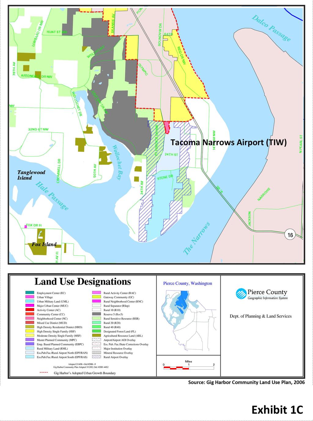
17 AIRSPACE For the safety of aircraft operations, it is important to protect the airspace around an airport. The FAA approved Airport Layout Plan (ALP) drawing set, prepared in 2003 as part of the last master plan, includes an Airspace Drawing. An Airspace Drawing illustrates the boundaries of imaginary airspace defined by the FAA. An Airspace Drawing is prepared in accordance with Title 14 Code of Federal Regulations Part 77, Objects Affecting Navigable Airspace, which defines a set of "imaginary surfaces" that should be protected from obstructions to air navigation, when possible. One of the most critical of these surfaces is the approach surface to each runway. The surface extending the farthest from the Airport is approximately 50,000 feet from the precision instrument runway end. The 2003 Airspace Drawing identified numerous trees as obstructions to be removed. Other obstructions identified included transmission towers, the Tacoma Narrows Bridge (with obstruction lighting), and a few airfield facilities such as navigational aids that are fixed by function. The seven trees at the south end of the airfield and four at the north end that were identified as obstructions during an engineering survey have been removed. Runway 17 uses a standard left traffic pattern while a non standard right traffic pattern is used for Runway 35. Non standard right traffic patterns are often implemented when area obstructions are present, community noise impacts require noise abatement procedures, environmentally sensitive areas must be avoided, or other issues need to be mitigated with traffic pattern adjustments. For Tacoma Narrows Airport, the right traffic pattern is applied as a noise abatement procedure and to avoid conflict between aircraft operating visually with those using the instrument departure procedure. The Airport is located within controlled Class D airspace during control tower operating hours and aircraft operating within this airspace must maintain radio contact while operating in the airspace. The airspace reverts to Class G uncontrolled airspace during hours the tower is closed. There is no special use airspace in the immediate vicinity of the Airport that restricts or limits aircraft operations. However, Military Operating Areas (MOAs) are located south of the Airport, which include Rainier 1, 2 and 3. A MOA is a type of special use airspace where military operations regularly occur that necessitate separation from civilian aircraft. OFF AIRPORT LAND USE AND DEVELOPMENT During the master planning process, it is important to review off airport land use for compatibility with airport operations. Over the years, residential encroachment around airports has become increasingly common and presenting challenges to meeting development needs and protecting the long term viability of the Airport. In 1996, WA legislators passed an amendment to the Growth Management Act requiring local jurisdictions with a public use airport to safeguard against incompatible land use development around their airports through Tacoma Narrows Airport Draft Inventory (May 2013) 1 15
18 their comprehensive plans and development regulations. In 1998, WSDOT Aviation provided public use airport communities with guidance to promote compatible land use development, which focused on the following key areas: height hazards that may impact critical airspace aircraft over flight and noise safety, particularly relative to higher risk areas for aircraft accidents, possible wildlife hazards, and hazardous/explosive materials WSDOT Aviation also recommended that jurisdictions with public use airports review and consider the findings of the airport master plans or other airport documents, the existing and proposed development shown on the airport layout plans, and any other relevant matters such as airport operations and aircraft and pilot characteristics. Further, these jurisdictions are required to coordinate with WSDOT Aviation when comprehensive plans and development regulations are available for comment prior to adoption or amendment. WSDOT Aviation encourages all jurisdictions surrounding an airport to cooperatively work together to protect the airport environs. According to the Land Use Plan presented in the 2006 Gig Harbor Community Plan Update, the Tacoma Narrows Airport land use designation is Essential Public Facility/Rural Airport. Exhibit 1C is an excerpt from the Community Plan Update that presents a color coded depiction of the land use plan including the Airport. The land use immediately surrounding the Airport is designated as Rural Airport Overlay. The Gig Harbor Urban Growth Boundary is to the north of the airport. In February 2012, a new residential subdivision Eagles Ridge sought a land use approval decision from Pierce County to commence development. Among other provisions, the Pierce County Hearing Examiner and County Council imposed a detailed avigation easement on the property s development to address land use compatibility issues of a subdivision within close proximity to the Airport. The avigation easement will be an integral component of all future land use decisions within the Rural Airport Overlay. FINANCIAL INVENTORY In the last four years since Pierce County purchased the Airport, revenues have averaged $729,000 with expenses averaging $691,000. However, expenses have exceeded revenues in the last few years as Pierce County has funded some much needed maintenance. Separate from operational revenues, the County receives grant funding to support capital improvements from the Airport. The Airport Improvement Program (AIP) is the funding source that is administered by the FAA. In the last four years, Pierce County has received an estimated $5.2 million from the FAA for airport improvements. Draft Inventory (May 2013) 1 16 Tacoma Narrows Airport
19
20 RATES AND CHARGES The County s rate and fee structure for 2013 includes hangar rental and tiedowns. The County does not charge landing fees. Hangars are typically referred to as T hangars or conventional hangars. However, conventional hangars may cover a wide variety of types/sizes with varying references when identifying them for rental purposes. Smaller conventional hangars may hold one aircraft while larger community hangars may store several aircraft. T hangars Monthly rent for T hangar space at Tacoma Narrows is $336.45, but T hangars with office space are 12% higher with a rent of $ Conventional hangars Conventional hangars rented at the Airport include various hangar types/size. A conventional hangar with dimensions of 65 by 65 feet is rented monthly for $1, while one with office space and a bathroom is rented for 30% more at $2, A smaller conventional hangar with dimensions of 60 by 60 feet is rented for $ monthly. Quad hangars are also available at the Airport, which refers to a single hangar with four units. The Airport rents these units for $ per month. Aircraft storage space is also rented in two community hangars. Each has some internal walls, but one has 40 foot doors and the other has 50 foot doors. Aircraft storage space within the 40 foot door hangar rents for $ monthly. The 50 foot door hangar includes a shared bathroom with rental rates as follows: Hangar space $ Hangar space with office $ Hangar space with storage $ Tiedowns The monthly tiedown rate at Tacoma Narrows is $49.60 for based aircraft, which are located on the north apron. The County charges $5 per night for transient aircraft tiedown space located adjacent to the ATCT. Tacoma Narrows Airport Draft Inventory (May 2013) 1 17
21 Economic Impact Completed in 2012 (with 2010 data), the WSDOT Economic Impact Study for airports in the Washington State Airport System calculated each airport s economic impact by reviewing economic activity directly tied to the Airport, such as jobs and visitors. A multiplier is applied to this activity to estimate indirect/induced impacts, which represent dollars re spent in the local economy; these dollars are a portion of the Airport wages and the business and visitor spending. For Tacoma Narrows Airport, the following estimated regional economic impacts were presented for airport businesses and visitor spending: Airport businesses 26 direct jobs, 14 indirect jobs $1.5 million labor income paid to direct jobs; $574,000 indirect $2.3 million direct output (estimated visitor spending that remains in the state); $1.6 million indirect Visitor Spending $1.473 million total estimated visitor spending 15 direct jobs, 7 indirect jobs $422,000 labor income paid to direct jobs; $346,000 indirect $1.2 million direct output (estimated visitor spending that remains in the state); $1.1 million indirect Draft Inventory (May 2013) 1 18 Tacoma Narrows Airport
Chapter One DRAFT INVENTORY
 Chapter One DRAFT INVENTORY Master Plan Update The Inventory Chapter documents the existing conditions for the (Airport) to include airport facilities and aviation activity. The information presented represents
Chapter One INVENTORY
 Chapter One INVENTORY Master Plan Update The Inventory Chapter documents the existing conditions for the (Airport) to include airport facilities and aviation activity. The information presented represents
Appendix D Project Newsletters. Tacoma Narrows Airport. Master Plan Update
 Appendix D Project Newsletters Tacoma Narrows Airport Master Plan Update This appendix contains the newsletters distributed throughout the project. These newsletters provided updates and information on
Document prepared by MnDOT Office of Aeronautics and HNTB Corporation. MINNESOTA GO STATE AVIATION SYSTEM PLAN
 LAST UPDATE JULY 2013 Acknowledgements The preparation of this document was financed in part by a grant from the Federal Aviation Administration (Project No: 3-27-0000-07-10), with the financial support
Chapter 9 - AIRPORT SYSTEM DESIGN
 Chapter 9 - AIRPORT SYSTEM DESIGN 9.01 GENERAL This chapter discusses the development program for Dutchess County Airport to the year 2020. This airport system design is based upon the airport's existing
Chapter 4.0 Alternatives Analysis
 Chapter 4.0 Alternatives Analysis Chapter 1 accumulated the baseline of existing airport data, Chapter 2 presented the outlook for the future in terms of operational activity, Chapter 3 defined the facilities
CHAPTER 1 BACKGROUND AND PROPOSED ACTION
 CHAPTER 1 BACKGROUND AND PROPOSED ACTION 1.0 INTRODUCTION An Environmental Assessment (EA) evaluates the effects of a proposed Federal action on the surrounding environment and is prepared in compliance
Addendum - Airport Development Alternatives (Chapter 6)
") Bowers Field Addendum - Airport Development Alternatives (Chapter 6) This addendum to the Airport Development Alternatives chapter includes the preferred airside development alternative and the preliminary
Bowers Field Addendum - Airport Development Alternatives (Chapter 6) This addendum to the Airport Development Alternatives chapter includes the preferred airside development alternative and the preliminary
CHAPTER 1 EXECUTIVE SUMMARY
 CHAPTER 1 EXECUTIVE SUMMARY 1 1 EXECUTIVE SUMMARY INTRODUCTION William R. Fairchild International Airport (CLM) is located approximately three miles west of the city of Port Angeles, Washington. The airport
Merritt Island Airport
 TABLE OF CONTENTS CHAPTER 1 INTRODUCTION... 1-1 INTRODUCTION AND PROJECT OVERVIEW... 1-1 General Guidelines... 1-1 Prior Planning Documentation... 1-2 Key Issues... 1-2 Goals and Objectives... 1-2 Regulatory
Vista Field Airport. Master Plan Update. February, Prepared for: Port of Kennewick One Clover Island Kennewick, Washington
 Vista Field Airport February, 2006 Prepared for: Port of Kennewick One Clover Island Kennewick, Washington 99336 Prepared by: J-U-B ENGINEERS, Inc. 2810 W. Clearwater Avenue, Suite 201 Kennewick, Washington
1.0 Project Background Mission Statement and Goals Objectives of this Sustainable Master Plan
 TABLE OF CONTENTS CHAPTER 1 INTRODUCTION 10 Project Background 1-1 11 Mission Statement and Goals 1-1 12 Objectives of this Sustainable Master Plan 1-2 CHAPTER 2 INVENTORY 20 Airport Background 2-1 201
1.1.3 Taxiways. Figure 1-15: Taxiway Data. DRAFT Inventory TYPICAL PAVEMENT CROSS-SECTION LIGHTING TYPE LENGTH (FEET) WIDTH (FEET) LIGHTING CONDITION
 WIDTH (FEET) LIGHTING CONDITION") 1.1.3 Taxiways EWN has an extensive network of taxiways and taxilanes connecting the terminal, air cargo, and general aviation areas with the runways as listed in Figure 1-15. A 50-foot wide parallel taxiway
1.1.3 Taxiways EWN has an extensive network of taxiways and taxilanes connecting the terminal, air cargo, and general aviation areas with the runways as listed in Figure 1-15. A 50-foot wide parallel taxiway
Preferred Alternative Summary
 Tacoma Narrows Airport Master Plan Update Preferred Alternative Summary The Preferred Alternative represents Pierce County s vision for the long-term development of the Tacoma Narrows Airport. This Alternative
The following criteria shall be applied within the boundaries of the AO District:
 Sec. 419 (a) Purpose AIRPORT OVERLAY DISTRICT (AO) The purpose of the Airport Overlay District is to regulate and restrict the height of structures, objects, or natural growth, regulate the locations of
Chapter Six ALP Drawings. Tacoma Narrows Airport. Master Plan Update
 Chapter Six ALP Drawings Master Plan Update The master planning process for the (Airport) has evolved through efforts in the previous chapters to analyze future aviation demand, establish airside and landside
Chapter Seven COST ESTIMATES AND FUNDING A. GENERAL
 Chapter Seven COST ESTIMATES AND FUNDING A. GENERAL This chapter delineates the recommended 2005 2024 Sussex County Airport Capital Improvement Program (CIP). It further identifies probable construction
Prepared By: Mead & Hunt, Inc Port Lansing Road Lansing, MI 48906
 Master Plan The preparation of this document was financed in part through a planning grant from the Federal Aviation Administration (FAA) as provided under Section 505 of the Airport and Airway Improvement
6.4 Aviation AVIATION FACILITIES AND SERVICES
 2035 Transportation Plan 6.4 Aviation This chapter describes existing aviation facilities and services in Placer County and projected needs. This chapter also discusses potential aviation issues related
Source: Chippewa Valley Regional Airport ASOS, Period of Record
 Chapter 1 Inventory Runway wind coverage is the percentage of time a runway can be used without exceeding allowable crosswind velocities. Allowable crosswind velocities vary depending on aircraft size
DRAFT FINAL REPORT AIRPORT MASTER PLAN. Rifle Garfield County Airport Revised May 15, 2014
 DRAFT FINAL REPORT AIRPORT MASTER PLAN Rifle Garfield County Airport Revised May 15, 2014 As required by Paragraph 425.B(4) of FAA Order 5100.38C, Airport Improvement Program (AIP) Handbook: The preparation
Chapter 2 FINDINGS & CONCLUSIONS
 Chapter 2 FINDINGS & CONCLUSIONS 2.01 GENERAL Dutchess County acquired the airport facility in 1947 by deed from the War Assets Administration. Following the acquisition, several individuals who pursued
Executive Summary. MASTER PLAN UPDATE Fort Collins-Loveland Municipal Airport
 Executive Summary MASTER PLAN UPDATE Fort Collins-Loveland Municipal Airport As a general aviation and commercial service airport, Fort Collins- Loveland Municipal Airport serves as an important niche
Appendix C AIRPORT LAYOUT PLANS
 Appendix C AIRPORT LAYOUT PLANS Appendix C AIRPORT LAYOUT PLANS Airport Master Plan Santa Barbara Airport As part of this Airport Master Plan, the Federal Aviation Administration (FAA) requires the development
ArcadiaMunicipalAirportislocatedonthesoutheast sideofarcadia,southofstateroute70,westofstate Route31,andisaccessiblefrom AirportRoad.
 Arcadia GeneralAviationAirport ArcadiaMunicipalAirportislocatedonthesoutheast sideofarcadia,southofstateroute70,westofstate Route31,andisaccessiblefrom AirportRoad.Arcadia islocatedapproximately30milesnortheastoftheport
ERIE INTERNATIONAL AIRPORT MASTER PLAN TABLE OF CONTENTS
 EXECUTIVE SUMMARY ERIE INTERNATIONAL AIRPORT MASTER PLAN TABLE OF CONTENTS PAGE NO. CHAPTER 1-INTRODUCTION... 1-1 1.01 General...1-1 1.02 Purpose and Scope of Study...1-1 1.03 The Planning Process...1-2
CHAPTER 3 ALTERNATIVES CONSIDERED
 CHAPTER 3 ALTERNATIVES CONSIDERED 3.0 ALTERNATIVES The 2010 Stevensville Airport Master Plan contained five (5) airside development options designed to meet projected demands. Each of the options from
Milton. PeterPrinceAirportislocatedinSantaRosaCounty, approximatelythreemileseastofmilton.
 Milton GeneralAviationAirport PeterPrinceAirportislocatedinSantaRosaCounty, approximatelythreemileseastofmilton. Existing Facilities Peter Prince Airport is served by one runway, Runway 18/36, 3,700 feet
Table of Contents. Master Plan March 2014 TOC i Spokane International Airport
 Table of Contents Page Chapter 1 Inventory 1. Introduction... 1 1 1.1 Community Profile... 1 2 1.1.1 Location and Setting... 1 1 1.1.2 Climate... 1 2 1.1.3 Socioeconomic Conditions... 1 5 1.1.4 Area Land
SouthwestFloridaInternational Airport
 SouthwestFloridaInternational Airport SouthwestFloridaInternationalAirportislocatedinLee CountyalongtheGulfCoastofSouthFlorida,tenmiles southeastofthefortmyerscentralbusinessdistrict. Theprimaryhighwayaccesstotheairportfrom
DRAFT MASTER PLAN UPDATE
 DRAFT MASTER PLAN UPDATE CHAPTER VI: AIRPORT LAYOUT PLAN NARRATIVE DRAFT REPORT APRIL 2017 PREPARED BY: Table of Contents WESTCHESTER COUNTY AIRPORT 6 AIRPORT LAYOUT PLAN NARRATIVE REPORT... 6-1 6.1 AGIS
Table of Contents. Overview Objectives Key Issues Process...1-3
 Table of Contents Chapter One Introduction Overview...1-1 Objectives...1-1 Key Issues...1-2 Process...1-3 Chapter Two Inventory of Existing Conditions Airport Setting...2-1 Locale...2-1 Airport Surroundings...2-5
MASTER PLAN CONCEPT 1 DRAFT
 The Airport Master Plan Update for Dallas Executive Airport has included the development of aviation demand forecasts, an assessment of future facility needs, and the evaluation of airport development
FACILITY REQUIREMENTS SUMMARY OF KEY ISSUES OVERVIEW
 FACILITY REQUIREMENTS SUMMARY OF KEY ISSUES OVERVIEW This summary is intended to provide a brief overview of the key issues associated with conformance to FAA standards at Methow Valley State Airport.
BELFAST MUNICIPAL AIRPORT OVERVIEW
 BELFAST MUNICIPAL AIRPORT OVERVIEW LOCATION AND HISTORY Belfast Municipal Airport (Federal Aviation Administration (FAA) airport code BST, International Civil Aviation Organization airport code KBST, FAA
Grants Pass Airport Master Plan & Airport Layout Plan Update
 Attendees: Grants Pass Airport Master Plan & Airport Layout Plan Update Meeting #3 January 26, 2010 Merlin Community Center 100 Acorn Street, Merlin 5:45 7:15 p.m. Josephine County Department of Airports:
CHAPTER 1: INTRODUCTION
 CHAPTER 1: INTRODUCTION Purpose and Scope The information presented in this report represents the study findings for the 2016 Ronan Airport Master Plan prepared for the City of Ronan and Lake County, the
Airport Master Plan Update June 15, 2017
 Airport Master Plan Update June 15, 2017 www.harveyfield.com The Master Plan is a 20-year plan to understand the needs of current and future users of the Airport. This is important to ensure that safe
Airport Master Plan Update June 15, 2017
 Airport Master Plan Update June 15, 2017 www.harveyfield.com The Master Plan is a 20-year plan to understand the needs of current and future users of the Airport. This is important to ensure that safe
Safety, Infrastructure, and Tenant Improvement Project. Public Hearing Informational Brochure February 26, 2013
 New York State Department of Transportation Safety, Infrastructure, and Tenant Improvement Project Public Hearing Informational Brochure February 26, 2013 This DEIS/Draft EA evaluates the potential impacts
AIRPORT MASTER PLAN. Newport State Airport. Draft. (Colonel Robert F. Wood Airpark) THE Louis Berger Group, INC. Prepared for: Prepared by:
 THE Louis Berger Group, INC. Prepared for: Prepared by:") Draft AIRPORT MASTER PLAN Newport State Airport () Prepared for: 2000 Post Road Warwick, Rhode Island 02886-1533 THE Louis Berger Group, INC. 20 Corporate Woods Boulevard Albany, New York 12211-2370 Prepared
Draft AIRPORT MASTER PLAN Newport State Airport () Prepared for: 2000 Post Road Warwick, Rhode Island 02886-1533 THE Louis Berger Group, INC. 20 Corporate Woods Boulevard Albany, New York 12211-2370 Prepared
Punta Gorda Airport Master Plan Update
 Punta Gorda Airport Master Plan Update Draft Executive Summary Prepared for: The Charlotte County Airport Authority January 2018 Charlotte County Airport Authority James Herston, Chair Robert D. Hancik,
Chapter The All-new, World-class Denver International Airport Identify Describe Know Describe Describe
 Chapter 10 The aerospace subject is very large and diverse. As seen in previous chapters, there are many subject areas. So far you have learned about history, weather, space and aerodynamics. Now you will
Finance and Implementation
 5 Finance and Implementation IMPLEMENTATION The previous chapters have presented discussions and plans for development of the airfield, terminal, and building areas at Sonoma County Airport. This chapter
CHAPTER 1 INTRODUCTION AND BACKGROUND
 CHAPTER 1 INTRODUCTION AND BACKGROUND An Environmental Assessment (EA) evaluates the effects of a proposed Federal action on the surrounding environment and is prepared in compliance with the National
STAFF REPORT. Airport Land Use Plan Consistency Review: Santa Barbara Airport Master Plan. MEETING DATE: November 19, 2015 AGENDA ITEM: 7D
 STAFF REPORT SUBJECT: Airport Land Use Plan Consistency Review: Santa Barbara Airport Master Plan MEETING DATE: AGENDA ITEM: 7D STAFF CONTACT: Peter Imhof, Andrew Orfila RECOMMENDATION: Adopt findings
CHAPTER 5 - FACILITY REQUIREMENTS
 CHAPTER 5 - FACILITY REQUIREMENTS This chapter identifies the requirements for airfield and landside facilities to accommodate the forecast demand level. Facility requirements have been developed for the
Kittitas County Airport Bowers Field Airport Master Plan Planning Advisory Committee Meeting #1 April 6, 2016
 Kittitas County Airport Bowers Field Airport Master Plan Planning Advisory Committee Meeting #1 April 6, 2016 Project Team Kittitas County, WA Airport Owner (Sponsor) and Operator, Land Use Century West
Chapter Four ALTERNATIVES
 Chapter Four ALTERNATIVES Master Plan Update This chapter walks through the process of identifying and evaluating development alternatives to serve the (Airport) in the near-term to the distant future.
Lake Tahoe Airport Master Plan Public Meeting March 16, 2015
 Lake Tahoe Airport Master Plan Public Meeting March 16, 2015 What is an Airport Master Plan? a comprehensive study of an airport [that] usually describes the short, medium, and long term development plans
Draft Concept Alternatives Analysis for the Inaugural Airport Program September 2005
 Section 10 Preferred Inaugural Airport Concept 10.0 Introduction The Preferred Inaugural Airport Concept for SSA was developed by adding the preferred support/ancillary facilities selected in Section 9
CHAPTER 5: Landside Facility Requirements and Development Concepts
 CHAPTER 5: Landside Facility Requirements and Development Concepts Overview Implementation of the preferred intermediate-term (10-year) and long-term (20-year) airside alternatives will have a significant
Chapter 4 Development Alternatives
 LAKE COUNTY AIRPORT MASTER PLAN UPDATE The preceding chapter identified deficiencies of the Lake County Airport (Airport) with respect to existing and anticipated aeronautical demand, which are consistent
Why are the underground fuel tanks being removed and replaced with above ground tanks?
 AIRPORT/CITIZEN FAQ This list of Frequently Asked Questions (FAQs) with responses are provided to share information related to airport topics with the Citizens of Georgetown. The questions / responses
Lake Tahoe Airport Master Plan
 Lake Tahoe Airport Master Plan City Council Briefing October 20, 2015 What is an Airport Master Plan? a comprehensive study of an airport [that] usually describes the short, medium, and long term development
TECHNICAL REPORT #7 Palm Beach International Airport Airport Layout Plan
 TECHNICAL REPORT #7 Palm Beach International Airport Airport Layout Plan Technical Report #7 Palm Beach International Airport Layout Plan Palm Beach International Airport Prepared for Palm Beach County
Yolo County Airport. ALP Narrative Report. April Prepared by Mead & Hunt, Inc. for the County of Yolo, California
 Yolo County Airport ALP Narrative Report April 2016 Prepared by Mead & Hunt, Inc. for the County of Yolo, California Yolo County Airport ALP Narrative Report Prepared for the County of Yolo Mindi Nunes,
10.1 INTRODUCTION NORTH PERRY AIRPORT MASTER PLAN UPDATE SECTION 10: CAPITAL IMPROVEMENT PROGRAM
 10.1 INTRODUCTION Based on the findings from the Facility Requirements and the combined plan recommended in the Alternative Analysis, a capital improvement program for North Perry Airport has been developed
Airport Master Plan Update
 Duttchessss Countty Airrporrtt Masstterr Plan Updatte Airport Master Plan Update Final Report Dutchess County Airport Town of Wappingers, New York C&S Engineers, Inc. 499 Col. Eileen Collins Blvd. Syracuse,
Airport Master Plan for Montgomery-Gibbs Executive Airport PAC Meeting #3
 Airport Master Plan for Montgomery-Gibbs Executive Airport PAC Meeting #3 Agenda > Introductions > Public Meetings Overview > Working Paper 3 - Facility Requirements > Working Paper 4 - Environmental Baseline
Lopez Island Airport Master Plan Update. Public Meeting June 15, 2017
 Lopez Island Airport Master Plan Update Public Meeting June 15, 2017 Master Plan Update Team Reid Middleton/Everett, WA Shannon Kinsella, Project Manager Melania Haagsma, Project Engineer Mead & Hunt/Tulsa,
Background Data: Lincoln Regional Airport and Environs
 6 Background Data: and Environs INTRODUCTION /Karl Harder Field is a former military training airfield built during World War II on a mile-square section of open rangeland some three miles west of central
Chapter One INVENTORY
 Chapter One INVENTORY Airport Layout Plan Report The initial step in the preparation of the Airport Layout Plan Report for is the collection of information pertaining to the Airport and the area it serves.
BUSINESS OF THE CITY COUNCIL CITY OF MERCER ISLAND, WA
 BUSINESS OF THE CITY COUNCIL CITY OF MERCER ISLAND, WA AB 4564 September 7, 2010 Regular Business RENTON AIRPORT STATUS UPDATE Proposed Council Action: Receive update. No action required. DEPARTMENT OF
Airport Master Plan for. Brown Field Municipal Airport PAC Meeting #3
 Airport Master Plan for Brown Field Municipal Airport PAC Meeting #3 Public Meeting #1 > 8/24/17 from 5:30 to 8:00 pm > 41 attendees signed-in > Comments: > EAA area > Environmental constraints > Focus
Airport Land Use Compatibility Plan (ALUCP) Update. Public Information Meeting #4 June 8 & 9, 2016
 Update. Public Information Meeting #4 June 8 & 9, 2016") Airport Land Use Compatibility Plan (ALUCP) Update Public Information Meeting #4 June 8 & 9, 2016 Agenda 1. Study Process 2. Noise Complaint Patterns 3. Proposed Overflight Areas (AOA) 4. Proposed Land
Airport Land Use Compatibility Plan (ALUCP) Update Public Information Meeting #4 June 8 & 9, 2016 Agenda 1. Study Process 2. Noise Complaint Patterns 3. Proposed Overflight Areas (AOA) 4. Proposed Land
Agenda: SASP SAC Meeting 3
 Agenda: SASP SAC Meeting 3 Date: 04/12/18 Public Involvement Plan Update Defining the System Recommended Classifications Discussion Break Review current system Outreach what we heard Proposed changes Classification
OREGON AVIATION PLAN AIRPORT SUMMARY CORVALLIS MUNICIPAL AIRPORT
 OREGON AVIATION PLAN AIRPORT SUMMARY CORVALLIS MUNICIPAL AIRPORT In 2018, the Oregon Department of Aviation (ODA) updated the Oregon Aviation Plan (OAP) for the state airport system which includes 95 airports,
1 PURPOSE AND NEED 1.1 INTRODUCTION
 1.1 INTRODUCTION 1 PURPOSE AND NEED This Environmental Assessment (EA) addresses projects at Juneau International Airport (JIA) that are the direct outcome of a Master Plan prepared for the airport and
The presentation was approximately 25 minutes The presentation is part of Working Group Meeting 3
 This is the presentation for the third Master Plan Update Working Group Meeting being conducted for the Ted Stevens Anchorage International Airport Master Plan Update. It was given on Thursday March 7
Airport Master Plan. Rapid City Regional Airport. October 2015 FAA Submittal
 Airport Master Plan Rapid City Regional Airport October 2015 FAA Submittal Rapid City Regional Airport Master Plan Update Table of Contents Executive Summary... i Scope & Timeline... i Forecasts... i Preferred
Airport Planning Area
 PLANNING AREA POLICIES l AIRPORT Airport Planning Area LOCATION AND CONTEXT The Airport Planning Area ( Airport area ) is a key part of Boise s economy and transportation network; it features a multi-purpose
STUDY WORK GROUP MEETING No. 3. November 29, 2016
 STUDY WORK GROUP MEETING No. 3 November 29, 2016 Agenda Welcome and introductions Update project schedule Brief overview of previous SWG meeting Update on aviation forecasts Introduction to airfield demand/capacity
Flying Cloud Airport (FCM) Zoning Process: Informing a Mn/DOT Path Forward
 Zoning Process: Informing a Mn/DOT Path Forward") : Informing a Mn/DOT Path Forward A Review of the Flying Cloud Airport (FCM) Joint Airport Zoning Board (JAZB) Process and the Draft Airport Zoning Ordinance B A RPZ RPZ A B C Zone Chad E. Leqve Director
: Informing a Mn/DOT Path Forward A Review of the Flying Cloud Airport (FCM) Joint Airport Zoning Board (JAZB) Process and the Draft Airport Zoning Ordinance B A RPZ RPZ A B C Zone Chad E. Leqve Director
Chapter 4 AIRPORT DEVELOPMENT ALTERNATIVES
 Chapter 4 AIRPORT DEVELOPMENT ALTERNATIVES Chapter Four Airport Development Alternatives Prior to formulating a development program for Ryan Airfield, it is important to consider development potential
Appendix 6.1: Hazard Worksheet
 Appendix 6.1: Appendix 6.1: Ref. Condition, real or potential; that can cause injury, illness, etc. This is a prerequisite for an Airfield Hazards 1. Taxiway Geometry Direct access to runway from ramp
CatExes vs. EAs When and How to Prepare
 CatExes vs. EAs When and How to Prepare Panel: Steve Culberson, Ricondo & Associates Frank Smigelski, FAA Mary Vigilante, Synergy Tuesday December 10, 2013 Washington, DC 1 So you have a project Do I have
AIRPORT LAND USE COMPATILIBILTY AIRPORT LAND USE COMPATIBILIITY
 CHAPTER 7 AIRPORT LAND USE COMPATILIBILTY CHAPTER 7 AIRPORT LAND USE COMPATIBILIITY 7.0 INTRODUCTION On airport aviation related development is typically compatible with aircraft operations. On airport
MONTEREY REGIONAL AIRPORT MASTER PLAN TOPICAL QUESTIONS FROM THE PLANNING ADVISORY COMMITTEE AND TOPICAL RESPONSES
 MONTEREY REGIONAL AIRPORT MASTER PLAN TOPICAL QUESTIONS FROM THE PLANNING ADVISORY COMMITTEE AND TOPICAL RESPONSES Recurring topics emerged in some of the comments and questions raised by members of the
CHAPTER 3 AIRPORT FACILITY REQUIREMENTS
 CHAPTER 3 AIRPORT FACILITY REQUIREMENTS 3.1 Introduction The existing runway and taxiway system at Skyhaven Airport provides more than adequate operational capacity to accommodate future peak hour and
Inventory of Existing Conditions.
 A Inventory of Existing Conditions. Fort Collins-Loveland Municipal Airport, jointly owned and operated by the Cities of Fort Collins and Loveland, is located in the heart of a region with a thriving economy,
PLU Airport Master Plan. Master Plan Advisory Committee (MPAC) Meeting #4 March 19, 2018
 Meeting #4 March 19, 2018") PLU Airport Master Plan Master Plan Advisory Committee (MPAC) Meeting #4 March 19, 2018 Meeting Agenda 1. Master Plan Status [5 Minutes] 2. Preferred Forecasts [15 Minutes] 3. Runway Length Options [45
PLU Airport Master Plan Master Plan Advisory Committee (MPAC) Meeting #4 March 19, 2018 Meeting Agenda 1. Master Plan Status [5 Minutes] 2. Preferred Forecasts [15 Minutes] 3. Runway Length Options [45
Airport Master Plan. Brookings Regional Airport. Runway Runway 17-35
 Runway 17-35 Airport Master Plan Runway 12-30 Brookings Regional Airport Table of Contents Table of Contents Chapter 1: Master Plan Goals... 1-1 1.1. Introduction... 1 1.2. Objective 1 Identify improvements
Westover Metropolitan Airport Master Plan Update
 Westover Metropolitan Airport Master Plan Update June 2008 INTRODUCTION Westover Metropolitan Airport (CEF) comprises the civilian portion of a joint-use facility located in Chicopee, Massachusetts. The
DRAFT GENERAL IMPLEMENTATION PLAN AND SPECIFIC IMPLEMENTATION PLAN MIDDLETON MUNICIPAL AIRPORT MOREY FIELD. Revised 12/12/03
 DRAFT GENERAL IMPLEMENTATION PLAN AND SPECIFIC IMPLEMENTATION PLAN MIDDLETON MUNICIPAL AIRPORT MOREY FIELD Revised 12/12/03 As recommended for approval by the Plan Commission General Project Description
Table of Contents. List of Tables. Cincinnati/Northern Kentucky International Airport 2035 Master Plan Update
 Table of Contents 7.1. Airport Layout Plan (Existing Conditions)... 2 7.2. Airport Layout Plan (Future Conditions)... 3 7.3. Technical Data Sheet... 5 7.4. Commercial Terminal Area Drawing... 5 7.5. East
COMMERCIAL AND GENERAL AVIATION
 Existing Facilities Daytona Beach International Airport is served by a number of airside and landside facilities. The airport has three asphalt runways: Runway 07L/25R (10,500 feet long by 150 feet wide),
CHAPTER 6 NOISE EXPOSURE
 CHAPTER 6 NOISE EXPOSURE FAA requires that the NEM submitted for review represent the aircraft noise exposure for the year of submittal (in this case 2008) and for a future year (2013 for OSUA). However,
Draft Concept Alternatives Analysis for the Inaugural Airport Program September 2005
 Draft Concept Alternatives Analysis for the Inaugural Airport Program September 2005 Section 3 - Refinement of the Ultimate Airfield Concept Using the Base Concept identified in Section 2, IDOT re-examined
chapter 5 Recommended Master Plan Concept airport master plan MASTER PLAN CONCEPT
 chapter 5 Recommended Master Plan Concept airport master plan The planning process for Coolidge Municipal Airport has included several analytical efforts in the previous chapters intended to project potential
Background Data: Blue Canyon Airport and Environs
 5 Background Data: and Environs INTRODUCTION serves as an important emergency landing field amid mountainous terrain. The airport has existed on the site since the 1930s or 40s. The facility was operated
Airfield Design OVERVIEW BASIC DESIGN FACTORS. Airport Role
 3 Airfield Design OVERVIEW Due to the presence of significant physical constraints, little change to the existing airfield is anticipated. The emphasis in this plan is on identifying airfield improvements
General Aviation Land Use Planning
 Our team. General Aviation Land Use Planning PURDUE ROAD SCHOOL - 2017 Presented by: Maria Muia, Ph.D., Senior Aviation Planner Woolpert, Inc. Brian Payne, Director Columbus Airport Nick Isenberg, Project
Chapter One INVENTORY
 Chapter One INVENTORY Airport Master Plan Update The purpose of the (Airport) Master Plan Update is to provide a means for documenting the Airport s short- and long-term needs. It will identify any issues
Airport Master Plan 1
 1 Aviation Demand AIRPORT PLANNING PROCESS FAA Design Standards Financial Resources Community Goals Environmental Requirements Serve Business Community This Advisory Circular (AC) provides guidance for
Technical Memorandum. Synopsis. Steve Carrillo, PE. Bryan Oscarson/Carmen Au Lindgren, PE. April 3, 2018 (Revised)
") Appendix D Orange County/John Wayne Airport (JWA) General Aviation Improvement Program (GAIP) Based Aircraft Parking Capacity Analysis and General Aviation Constrained Forecasts Technical Memorandum To:
Appendix D Orange County/John Wayne Airport (JWA) General Aviation Improvement Program (GAIP) Based Aircraft Parking Capacity Analysis and General Aviation Constrained Forecasts Technical Memorandum To:
1 DRAFT. General Aviation Terminal Services Aircraft Hangars Aircraft Parking Aprons Airport Support Facilities
 To properly plan for improvements at Dallas Executive Airport, it is necessary to translate forecast aviation demand into the specific types and quantities of facilities that can adequately serve the demand.
Land Use and Environmental Control
 ICAO-ACI/LAC Seminar on Bird Hazards, Environmental Protection and Land Use at Airports for the NAM/CAR/SAM (Americas) Regions Miami, 24-27 April 2001 Land Use and Environmental Control Michiel Vreedenburgh
STAFF REPORT. Airport Land Use Plan Consistency Review: Old Town Village Mixed Use Project City of Goleta. MEETING DATE: June 18, 2015 AGENDA ITEM: 5M
 STAFF REPORT SUBJECT: Airport Land Use Plan Consistency Review: Old Town Village Mixed Use Project City of Goleta MEETING DATE: AGENDA ITEM: 5M STAFF CONTACT: Peter Imhof, Andrew Orfila RECOMMENDATION:
AIRPORT MASTER PLAN UPDATE
 AIRPORT MASTER PLAN UPDATE PENSACOLA INTERNATIONAL AIRPORT Technical Advisory Committee Meeting #2 June 20, 2017 Agenda» Introduction» Facility Requirements Airside Terminal Landside General Aviation Cargo