Pilot s Guide 2007 HuAF 59th AB, Kecskemét
|
|
|
- Scarlett Parker
- 5 years ago
- Views:
Transcription

1 Pilot s Guide 2007 HuAF 59th AB, Kecskemét 1
2 Table of contents 2. Table of contents 3. Welcome 4-6. Part 1- General Part 2 Execution 15. Duty Call list Annexees 2
3 Welcome to 59 th Air Base at Kecskemét. As participants of our international Air Display I salute You personally and on behalf of my staff. General István Petı This Pilot s Guide is meant as a quick reference guide for flying. Basically the airshow is planned according to STANAG 3533 In the unlikely event that we have missed information don t hesitate to ask your Liaison officer. Enjoy your stay at Kecskemét! 3
 at a latitude of 4655 04,17")

4 PART 1- GENERAL DESCRIPTION OF THE GEOGRAPHIC AREA IN WHICH THE AIRPORT LOCATED: General information The airport is situated really close, 4km east of centre Kecskemét, at a hight of 381 feet (above sea level) at a latitude of ,17 N and a longitude ,10 E. Particular geographic reference points The airport is located almost the centre of Hungary,on the northern part of the so-called Sand Ridge area, surrounded by two rivers,from west river Danube, from east river Tisza. 4
5 General meteorological conditions The climate which characterizes the area is typical of a continental one. The Carpathians and the Alps are have a significant influence on climate and meteorological conditions.the Alps which reaches the height of 6000 to 9000 feet is able to stop the entrance of cold air currents from Northen Europe. Precipitation falls year round. Seasons are variable, however temperatures rarelly fall below minus 15 C or climbe higher than 35 C. Winds are normally week with occasional significant gusts associated with cold fronts and storm activity. The wind blows predominatelly from the north - west. Wind speed is generally around 8 kts, while the strongest gusts of wind recorded 60 kts. Cloud cover is generally not heavy, exept winter time especially December and January, when fog and mist are quite frequent. During the period of October to March, it is possible to have conditions where ceiling is bellowe 2000 feet and visibility is reduced to less than 5 km. These types of conditions are also possible in summer months during early morning hours. AIRSPACE AND AIRPORT DESCRIPTION General information Toponimic Indicator: LHKE Classification: Military Airport (open to civil traffic*) Airport Reference Point ( center of runway ): ,17 N ,10 E Airport Elevation:373ft 113,69m Airport Reference Temperature: 14,2 C Magnetic Declination: 2,3 East (rising as of 1996) Type of Traffic: General (civil and military) and Operational Traffic Hours of Service: H24 * For Civilian Traffic need a prior permission from the Chief of Joint Forces. SERVICES Air Traffic Control Services General information 5
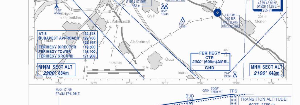
6 The following units operate under this section TWR Unit RADAR Unit - APP Unit A.R.O. Unit - hours of operation 24 The Air Traffic Section (TWR) located in the Operative area in central position in comparison to the lenght of the runway. Aerodrom Reporting Office (ARO) The ARO is located inside the Operative area, zone TWR. Structure and Equipment: Flight Plan Office - desks and chairs for the compellation and presentation of flight plans and for consulting aeronautical information - Airport Grid Map Implant - AFTN and RAFT systems for the reception and sending of FPL messages - Internatinal telephone line - National Documentation - ICAO Documentation - International Publications - FPL Forms - Regulations For Military Traffic - Topografhic and Air Navigation Charts - Computer, complite with printer for the registration of arriving or departing flights Meteorological services located inside the Operative area, zone TWR. AMO: 1 st class- hours of operaton 24, transmission of METARs in half-hourly ATIS not avaiable Available Forecasts: - FC TAF (short): , , , , , Weather Route Folders Available: - according to the flight plan - on pilot request. 6
7 AMBULANCE and FIRE FIGHTING SERVICES General Information: These services are regulated under ICAO norms (DOC 9137) Category 7 TIMING: All timings are in U.T.C. PART 2- EXECUTION The Kecskemét A/B Airshow time period is: August 2007 From 08:15 to 15:45 Aircraft participating in the STATIC DISPLAY should plan their arrival at KECSKEMÉT AB before 10 August 12:00 Possibility for rehearsal will be given on request on 10 August from 12:00 to 16:00. The request for a rehearsal must be filed in the Questionnaire for participants". DEPARTURE OF PARTICIPATING AIRCRAFT A departure plan will be made in accordance with aircrew requests. Aircraft may depart on Sunday 12 August after completion of the Air Display from 16:00 Monday 13 August from 08:00 Tuesday 14 August from 06:00 Flight planning should be conducted upon arrival after processing at Aircrew Reception via AIS, in the tower building. BRIEFINGS Briefing will be held in the Information Centre. A mandatory briefing for the REHEARSAL/AIRSHOW will be given for team leaders and individual pilots according to the following schedule: Rehearsal Briefings: 10 August upon aircrew request Airshow Briefings: 11 and 12 August 06:30 10:30 NO BRIEF = NO FLY 7
8 AIRSHOW RULES AND RESTRICTIONS: General Rules: Display-Line 1 will be situated between runway 30/12 and Central Zone (100 meters from the spectator line) for aircraft displaying with speeds not exceeding 300 KIAS). All restrictions will be briefed to all participants during the airs howbriefings. Display-Line 2 (the main display-line) will be the centre-line of grassy emergency strip 30/12 (310 meters from the spectator line, signed by orange coloured marks). All JET displays and displays with speeds exceeding 300 KIAS will take place NORTH-EAST of that line in accordance with STANAG 3533 and/or national regulations. The display centre is the runway in front of the Central Zone. Restrictions: The overflight of the public area is STRICTLY forbidden, except for aircraft that are positioning for paradispatch. The minimum altitude in this case will be 1500 feet AGL. Turns towards the public and executed at speeds exceeding 300 KIAS must be completed at 450 meters (Display-Line 3) from the spectator line. In all other cases the minimum distance for jet aircraft and aircraft exceeding 300 KIAS will be 310 meters from the spectator line. Turns towards the public and executed at speeds less 300 KIAS must be also completed at 310 meters from the spectator line. In all other cases the minimum distance for aircraft not exceeding 300 KIAS will be 100 meters from the spectator line. Hovering manoeuvres: Speed: - Rotary a/c not closer than 100 m to the spectator line. - VSTOL a/c only overhead RWY 30/12. Aircraft must not exceed whichever is the lower of a true speed of MACH 0.95 or 600 KIAS. Altitude restrictions: Recovery from any manoeuvres and turns within the flying display zone - CAT B, C, D, E 300ft - CAT A 100ft These altitudes are STRICTLY COMPLIANT unless national rules dictate higher limits or special permission is granted in advance by the Display Director for lower altitude. It is STRICTLY PROHIBITED to carry nonessential aircrew and/or passengers during rehearsal and flying displays. No manoeuvre is to be attempted which is likely to jeopardise the safety of spectators in the event of mishap or misjudgement. Engines are not to be shut down during flying demonstrations. 8
9 Use of chaffs/flares is not permitted. Aircraft are not allowed to fly outside the Display Air Traffic Zone during their display. Additional restrictions will be briefed at the briefings. During display, aircrew that infract these rules will be sanctioned by an order to terminate the presentation. Repeated or serious breaches will result in the pilot's suspension from the flying display for the remainder of the Airshow. DISPLAY SAFTEY COMMITTEE The Display Safety Committee (DSC) members of which will be identified at the Display Briefings, DSC will monitor all rehearsals and flying displays. Aircrew will receive a warning if the display limits are exceeded marginally. Should the DSC require a display to be terminated, for whatever reason, Air Traffic Control will broadcast Call-sign, STOP, STOP, STOP. On hearing this call the pilot should stop his display immediately and turn downwind for landing. Such curtailment should not be taken to imply automatically that the pilot has in any way infringed the flying regulations. The broadcast may have been necessitated by other safety considerations. AIR TRAFFIC CONTROL General NATO control procedures will apply. English language will be used for all air-ground/ground-air communications. Airspace structure Temporary Areas Display Air Traffic Zone (DATZ) includes: 1. LHKE MCTR - TEMPORARY AREA 1 2. LHKE MTMA 1 - TEMPORARY AREA 2 3. LHKE MTMA 2 - TEMPORARY AREA 3 4. LHBP TMA 9 - TEMPORARY AREA 4 5. LH-TRA 12 - TEMPORARY AREA 5 6. LHSN MCTR - TEMPORARY AREA 6 7. LHSN MTMA - TEMPORARY AREA 7 9
10 TEMPORARY AREA 1 (LHKE MCTR) LATERAL LIMITS UPPER / LOWER LIMIT REMARKS N N N N N N N E E E E E E E 4000 (1200m AMSL) GND Lateral limits are designated by a circle with 10 km radius centered N E (ARP), joined to the area bounded by straight lines connecting the given coordinates. TEMPORARY AREA 2 (LHKE MTMA 1) N N N N N N N Lateral limits Upper / lower limit Remarks E E E E E E E FL175 (5350 m STD) / GND TEMPORARY AREA 3 (LHKE MTMA 2) N N N N N N N Lateral limits Upper / lower limit Remarks E E E E E E E FL175 (5350 m STD) / 2000' (600 m) AMSL TEMPORARY AREA 4 (LHBP TMA 9) Lateral limits Upper / lower limit Remarks N N N N N E E E E E FL175 (5350 m STD) / 2000' (600 m) AMSL 10
11 TEMPORARY AREA 5 (LH-TRA 12) Lateral limits N N N N N N E E E E E E Upper / lower limit FL115 (3500 m STD) / GND Remarks TEMPORARY AREA 6 (LHSN MCTR) Lateral limits Upper / lower limit Remarks N N N N N E E E E E 4000' (1200 m) AMSL / GND TEMPORARY AREA 7 (LHSN MTMA) Lateral limits Upper / lower limit N N N N N N N N N N E E E E E E E E E E FL125 (3800 m STD) / GND Communications during air display Start-up approval: KECSKEMÉT GND 121,750 MHz Taxi instruction: KECSKEMÉT GND 121,750 MHz Display: KECSKEMÉT TWR MHz Clearance delivery KECSKEMÉT TWR 134,250MHz 11
12 Display Callsigns Callsigns are to be issued by aircrews for ATC. Altimeter setting KECSKEMÉT AB QNH will be used at all times. QFE will be issued upon taxiing ON REQUEST. IFR Arriving controlled flights will normally be vectored by ATC or the final approach of the runway in use in order to expedite the traffic flows in MTMA. Radar vectoring procedures are applied in accordance with the regulation prescribed in ICAO doc part VI. Section 6.5. EMERGENCIES In-flight emergency In case of an in-flight emergency proceed, if circumstances permit, to the alternate airfield! Cables and Barriers The active runway will be supplied with a departure-end cable, type BAK-12 SC. Recommended Maximum Engaging Velocity: 190 KTS (352km/h) On the airport there is an Arresting Net System (BARRIER -ATU-2M), which is located at the end of runway, behind the operating area of the BAK-12. Maximum Arresting Mass : 12000kg, max. speed 119 KTS (220km/h) 20000kg, max speed 097 KTS (180km/h) Hydrazine When hydrazine decontamination/clean up is required, inform TWR: RWY 30: at the end of runway turn right RWY 12 at the end of runway turn left Park the aircraft with the nose into the wind and await the fire brigade instructions and assistance. Hot Brakes Runway 30 in use: Turn left, vacate runway via TWY D, stop on the apron, inform TWR and await fire brigade assistance and instructions. Runway 12 in use: Turn right, after vacation runway via TWY A stop the aircraft, don t block inform TWR and await fire brigade assistance and instructions. Use of Dragchute In case you need to use the dragchute on landing drop the dragchute in the designated slow lane as close as possible to the runway edge. Mind the runway lighting. 12
13 Jettison and Bailout area Jettison Area Bailout Area Bailout & Fuel Dumping Altitude for fuel dumping: 3050 m (FL100) or above Coordinates N N N N E E E E Bailout /Fuel dumping Area Jettison Area 200m (600 feet) North-East of the Emergency Strip. Jettison height: 300 m (1000 feet) 13
14 Obstacles in DATZ (reference point ARP): TDZE RWY 30/12 113,69m/ 373 Obstacles Feet / meter (AGL) Feet / meter (AMSL) Azimuth Distance METEO radar 56 / 17 m ,7m m ASR (RL-2000 MSSR1) 99 / 29,9 m ,6m m GP antenna RWY / 15m ,7m m GP antenna RWY / 15m ,7m m Buildings 50 / 15,7 m ,4m m Building 40 / 12 m ,7m m MASS 209 / 63.5 m ,2m m Kecskemét city 164 / 50 m ,7m km Church 60 / 18m ,7m km TV transmitter 710 / 216 m ,7m km COMMUNICATION FAILURE stop the show set SQUAWK 7600 proceed DOWNWIND and land immediately wait for FOLLOW ME vehicle 14
15 DUTY CALL LIST Kecskemét international area code: Kecskemét national area code: 0676 Military area code (Kecsekmét): 43 Military prefix: 02 (you do not have to use inside the base) Commercial line prefix: 01 Duty TWR A.R.O. METEO 43/2145 Building 20 breifing room Flight coordination group Maintenance tower Building 145 (Maintenance) Base duty officer 43/2566 Base ambulance 43/2300 Base fire brigade 43/2400 City ambulance 104 City fire brigade 105 Police station 107 Any kind of emergency in town Phone number 76/ /2803 Telefax: 43/ / /2538, 43/2835 Telefax: 76/ Telefax: 43/ /2136, 43/ /2708, 43/2813 Telefax: 76/ , Telefax: 43/ /2323 Telefax: 76/ Telefax: 43/2776 Telefax: 76/ Telefax: 43/
16 LIST OF ANNEXEES ANNEX A ANNEX B ANNEX C ANNEX D ANNEX E ANNEX F ANNEX G ANNEX H ANNEX I ANNEX J ANNEX K ANNEX L ANNEX M ANNEX N ANNEX O ANNEX P ANNEX Q ANNEX R MTMA AERODROME LAYOUT/RADAR AERODROME GROUND MOVEMENT CHART ILS RWY 30 KECSKEMET ILS RWY 12 KECSKEMET NDB RWY 30 KECSKEMET NDB RWY 12 KECSKEMET DISPLAY LINES ALTERNATE PAPA NDB RWY 34 PAPA NDB RWY 16 PAPA ALTERNATE SZOLNOK NDB RWY 20 SZOLNOK EMERGENCY AIRFIELD BUDAPEST ILS RWY 13L BUDAPEST ILS RWY 31R BUDAPEST NDB RWY 13L BUDAPEST NDB RWY 31R BUDAPEST 16

17 ANNEX A 17
18 ANNEX B 18
19 ANNEX C 19
20 ANNEX D 20
21 ANNEX E 21
22 ANNEX F 22

23 ANNEX G 23
24 ANNEX H 24
25 AERODROM GROUND MOVEMENT CHART (LHPA) ANNEX I APRON G TRESHOLD RWY TWY E TWY C APRON APRON TWY TWY B TWR TWY TWY APRON J APRON P APRON L APRON M TWY TWY A NO ENTRY APRON 25
26 ANNEX J 26
27 RACETRACK APPROACH PROCEDURE RWY 34 ANNEX K 27
28 ANNEX L AD GROUND MOVEMENT CHART (LHSN) Rwy heading: 200 / 020 Rwy use: 20 / 02 Rwy dimensions length / width: 2000m / 70m Rwy surface: 18 cm concrete covered by 16 cm asphalt Rwy strength: LCN 30; PCN 21 Barrier: Rwy 02 ATU t km/h Rwy 20 ATU-2M t km/h Emergency landing strip: 2000 m / 50 m Nr. AREA LCN PCN 1. Runway 30 21/R/D/Y/T 2. TWY A 32 22/R/D/Y/T 3. TWY B 26 18/R/D/Y/T 4. TWY C 21 14/R/D/Y/T 5. TWY D 33 22/R/D/Y/T 6. TWY E 21 14/R/D/Y/T 7. TWY F 23 15/R/D/Y/T 8. TWY G 23 15/R/D/Y/T 9. TWY H 23 15/R/D/Y/T 10. TWY I TWY J TWY K APRON /R/D/Y/T 14. APRON D 32 22/R/D/Y/T 15. APRON 33 22/R/D/Y/T 16. APRON /R/D/Y/T 17. MI-24 heli stands 23 15/R/D/Y/T 18. MI-8, MI-17 helicopter stands 28
29 ANNEX M 29
30 KECSKEMÉT AIR SHOW 2007 Pilot s Guide ANNEX N 30

31 ANNEX O 31
32 32

33 ANNEX P 33
34 34

35 ANNEX Q 35
36 36

37 ANNEX R 37
38 38
AD 2. AERODROMES VAKS AD 2.2 AERODROME GEOGRAPHICAL AND ADMINISTRATIVE DATA
 AD 2-1 AD 2. AERODROMES AD 2.1 AERODROME LOCATION INDICATOR AND NAME - KESHOD / DOMESTIC AD 2.2 AERODROME GEOGRAPHICAL AND ADMINISTRATIVE DATA 1 Aerodrome reference point coordinates and its site 2 Direction
Display Order Pardubice Airshow 2018, Pardubice
 In Pardubice, 1 May 2018 Print number: el.copy Pages: 6 Annexes: 9 To all participants from abroad Display Order Pardubice Airshow 2018, Pardubice List of changes: Based on the Czech Aviation Law (Act
Flight Director Regulation for AIR SHOW in Mlada Boleslav, 16 June 2016
 In Mlada Boleslav, 11 th June 2016 6 Flight Director Regulation for AIR SHOW in Mlada Boleslav, 16 June 2016 (Flight Director Information and obligatory instructions leading to performance of the 11th
EGSL ANDREWSFIELD EGSL AD 2.1 AERODROME LOCATION INDICATOR AND NAME EGSL AD 2.2 AERODROME GEOGRAPHICAL AND ADMINISTRATIVE DATA
 UNITED KINGDOM AIP AD 2.EGSL-1 26 May 2016 EGSL ANDREWSFIELD EGSL AD 2.1 AERODROME LOCATION INDICATOR AND NAME EGSL ANDREWSFIELD EGSL AD 2.2 AERODROME GEOGRAPHICAL AND ADMINISTRATIVE DATA 1 ARP coordinates
EVTA AD 2.1 AERODROME LOCATION INDICATOR AND NAME EVTA AD 2.2 AERODROME GEOGRAPHICAL AND ADMINISTRATIVE DATA
 18 NOV 2010 AIP LATVIA EVTA AD 2-1 18 NOV 2010 Note: The following sections in this chapter are intentionally left blank: AD-2.11, AD-2.14, AD-2.15, AD-2.16, AD- 2.19, AD-2.20, AD-2.21, AD-2.23 EVTA AD
PREDANNACK AD LOCATION INDICATOR AND NAME PREDANNACK PREDANNACK AD AERODROME GEOGRAPHICAL AND ADMINISTRATIVE DATA. 2nm SE of Mullion.
 AD 2 - - 1-1 AD 2.1 - LOCATION INDICATOR AND NAME AD 2.2 - AERODROME GEOGRAPHICAL AND ADMINISTRATIVE DATA 1 ARP Co-ordinates and site at AD: 2 Direction and distance from City: 3 Elevation/Reference Temperature:
RWY 24. Designator Route Remarks. All traffic shall initially climb to 4000FT QNH with climb gradient 3.3% MNM, unless instructed otherwise by ATC.
 AD 2.ELLX-15 DISKI 2Y GTQ 7X GTQ 7Y MMD 7X RAPOR 4X 3.2.2 Climb Requirements RWY 24 Designator Route Remarks R-238 LUX to 8 DME LUX, RT to intercept R-222 NTM to 24 DME NTM, RT R-156 DIK, LT R-115 LUX
SECTION 4 - APPROACH CONTROL PROCEDURES
 SECTION 4 - APPROACH CONTROL PROCEDURES CHAPTER 1 - PROVISION OF SERVICES 1.1 An approach control unit shall provide:- a) Approach control service. b) Flight Information service. c) Alerting service. RESPONSIBILITIES
AD 2. AERODROMES VOAT AD 2.2 AERODROME GEOGRAPHICAL AND ADMINISTRATIVE DATA
 AD 2-1 AD 2. AERODROMES AD 2.1 AERODROME LOCATION INDICATOR AND NAME - AGATTI / DOMESTIC AD 2.2 AERODROME GEOGRAPHICAL AND ADMINISTRATIVE DATA 1 Aerodrome reference point coordinates and its site 2 Direction
AD 2. AERODROMES DEELEN
 MilAIP NETHERLANDS EHDL AD 2-1 AD 2. AERODROMES DEELEN EHDL AD 2.1 Aerodrome location indicator and name EHDL - Deelen EHDL AD 2.2 Geographical and administrative data 1 ARP 52 03 35.02 N 005 52 18.97
LRBC AD 2.1 AERODROME LOCATION INDICATOR AND NAME LRBC BACĂU / Bacău LRBC AD 2.2 AERODROME GEOGRAPHICAL AND ADIMNISTRATIVE DATA
 AD 2.4-1 LRBC AD 2.1 AERODROME LOCATION INDICATOR AND NAME LRBC BACĂU / Bacău LRBC AD 2.2 AERODROME GEOGRAPHICAL AND ADIMNISTRATIVE DATA 1 ARP coordinates and site at AD N 46 31 19 E 026 54 37 RWY center
Oostwold Airshow 2017
 Oostwold Airshow 2017 Briefing for visiting aircraft 4 th and 5 th June 2017 Dear pilots This document deals with procedures to be employed during the Oostwold Airshow days on June 4 th and 5th 2017 only.
TVSC CANOUAN/Canouan Is. (ST. VINCENT AND THE GRENADINES)
") AIP AD 2. AERODROMES AD 2.921 17 MAY 01 TVSC AD 2.1 AERODROME LOCATION INDICATOR AND NAME TVSC CANOUAN/Canouan Is. (ST. VINCENT AND THE GRENADINES) TVSC AD 2.2 AERODROME GEOGRAPHICAL AND ADMINISTRATIVE
AIP AD 2. AERODROMES AD 2.921 17 MAY 01 TVSC AD 2.1 AERODROME LOCATION INDICATOR AND NAME TVSC CANOUAN/Canouan Is. (ST. VINCENT AND THE GRENADINES) TVSC AD 2.2 AERODROME GEOGRAPHICAL AND ADMINISTRATIVE
Standard Operational Procedures
 Standard Operational Procedures Aerodrome Ostrava Mošnov VERSION 1.2 CHANGES AND UPDATES Effective Version Change 24 JUN 09 1.1 LVP added. 12 FEB 11 1.2 General text revision. NOTES Official scenery and
VFR PHRASEOLOGY. The word IMMEDIATELY should only be used when immediate action is required for safety reasons.
 VFR PHRASEOLOGY 1. Introduction 1.1. What is phraseology? The phraseology is the way to communicate between the pilot and air traffic controller. This way is stereotyped and you shall not invent new words.
EGWN AD 2.1 LOCATION INDICATOR AND NAME EGWN - HALTON EGWN AD AERODROME GEOGRAPHICAL AND ADMINISTRATIVE DATA. 3 5nm SE of Aylesbury
 UK MIL AIP AD 2 - EGWN - 1-1 04 AUG 05 EGWN AD 2.1 LOCATION INDICATOR AND NAME EGWN - EGWN AD 2.2 - AERODROME GEOGRAPHICAL AND ADMINISTRATIVE DATA 1 ARP Co-ordinates and site at AD: 2 Direction and distance
AD 2-OERY-1 7 JAN 16 OERY AD 2.1 AERODROME LOCATION INDICATOR AND NAME. OERY - RIYADH/ King Salman Air Base
 AD 2-OERY-1 OERY AD 2.1 AERODROME LOCATION INDICATOR AND NAME OERY - RIYADH/ King Salman Air Base OERY AD 2.2 AERODROME GEOGRAPHICAL AND ADMINISTRATIVE DATA 1 ARP coordinates and site at AD 244319N 0464329E/
AD 2. AERODROMES VEBI AD 2.2 AERODROME GEOGRAPHICAL AND ADMINISTRATIVE DATA
 AD 2-1 AD 2. AERODROMES AD 2.1 AERODROME LOCATION INDICATOR AND NAME - BARAPANI / DOMESTIC AD 2.2 AERODROME GEOGRAPHICAL AND ADMINISTRATIVE DATA 1 Aerodrome reference point coordinates and its site 2 Direction
REPUBLIC OF MALDIVES
 Tel:( +960) 333 7149 ( +960) 333 7250 E-mail: aishq@macl.aero AFTN: VRMMYNYX FAX: (+960) 331 3258 REPUBLIC OF MALDIVES AERONAUTICAL INFORMATION SERVICE AIR TRAFFIC SERVICES Velana International Airport
ARP N W m. Rwy 21 Thr Elev N W. (GUND Elevation 172) 153 M. 853m x 27m.
 153 M. 853m x 27m.") 09 27 UK AIP (28 Jul 11) AD 2-EGPT-2-1 AERODROME CHART - ICAO ARP 562628N 0032226W AD ELEV 397FT PERTH/SCONE EGPT GUND (Geoid Undulation) = The height of the Geoid (MSL) above the Reference Elipsoid (WGS
09 27 UK AIP (28 Jul 11) AD 2-EGPT-2-1 AERODROME CHART - ICAO ARP 562628N 0032226W AD ELEV 397FT PERTH/SCONE EGPT GUND (Geoid Undulation) = The height of the Geoid (MSL) above the Reference Elipsoid (WGS
MilAIP NETHERLANDS EHEH AD 2-1 EINDHOVEN. EHEH AD 2.1 Aerodrome location indicator and name. EHEH AD 2.2 Geographical and administrative data
 MilAIP NETHERLANDS EHEH AD 2-1 EINDHOVEN EHEH AD 2.1 Aerodrome location indicator and name EHEH - Eindhoven EHEH AD 2.2 Geographical and administrative data 1 ARP 51 27 00.48 N 005 22 28.25 E 2 Direction
LZMC/MLC MALACKY 01 JAN IEff 01 FebI. MALACKY, SLOVAKIA Additional Airport Informations. 1. Services ATC and Meteo services available H24.
 MALACKY 01 JAN 08 10 1 I Additional Airport Informations 1. Services ATC and Meteo services available H24. Telephone numbers: TWR: 00421 960 390 230 00421 960 390 231 METEO Office: 00421 960 390 240 00421
AD 2. AERODROMES VIBR AD 2.2 AERODROME GEOGRAPHICAL AND ADMINISTRATIVE DATA
 AD 2-1 AD 2. AERODROMES AD 2.1 AERODROME LOCATION INDICATOR AND NAME - KULLU MANALI / DOMESTIC AD 2.2 AERODROME GEOGRAPHICAL AND ADMINISTRATIVE DATA 1 Aerodrome reference point coordinates and its site
AD 2. AERODROMES VOPN AD 2.2 AERODROME GEOGRAPHICAL AND ADMINISTRATIVE DATA
 AD 2-1 AD 2. AERODROMES AD 2.1 AERODROME LOCATION INDICATOR AND NAME - SRI SATHYA SAI / DOMESTIC AD 2.2 AERODROME GEOGRAPHICAL AND ADMINISTRATIVE DATA 1 Aerodrome reference point coordinates and its site
Northern Regional Training Scheme. EGNT Newcastle Aerodrome Pilot s Guide. REVISION 2 (Wednesday, 03 August 2011 at 15:51)
") Northern Regional Training Scheme EGNT Newcastle Aerodrome Pilot s Guide REVISION 2 (Wednesday, 03 August 2011 at 15:51) PUBLISHED Wednesday, 03 August 2011 1 Contents 1 Contents... 2 2 Departures... 3
Northern Regional Training Scheme EGNT Newcastle Aerodrome Pilot s Guide REVISION 2 (Wednesday, 03 August 2011 at 15:51) PUBLISHED Wednesday, 03 August 2011 1 Contents 1 Contents... 2 2 Departures... 3
TVSU UNION ISLAND/Union Is. (ST. VINCENT AND THE GRENADINES)
") AIP AD 2.951 AD 2. AERODROMES TVSU AD 2.1 AERODROME LOCATION INDICATOR AND NAME TVSU UNION ISLAND/Union Is. (ST. VINCENT AND THE GRENADINES) TVSU AD 2.2 AERODROME GEOGRAPHICAL AND ADMINISTRATIVE DATA 1
AIP AD 2.951 AD 2. AERODROMES TVSU AD 2.1 AERODROME LOCATION INDICATOR AND NAME TVSU UNION ISLAND/Union Is. (ST. VINCENT AND THE GRENADINES) TVSU AD 2.2 AERODROME GEOGRAPHICAL AND ADMINISTRATIVE DATA 1
TVSB BEQUIA IS./J.F. Mitchell (ST. VINCENT AND THE GRENADINES)
") AIP AD 2. AERODROMES AD 2.911 TVSB AD 2.1 AERODROME LOCATION INDICATOR AND NAME TVSB BEQUIA IS./J.F. Mitchell (ST. VINCENT AND THE GRENADINES) TVSB AD 2.2 AERODROME GEOGRAPHICAL AND ADMINISTRATIVE DATA
AIP AD 2. AERODROMES AD 2.911 TVSB AD 2.1 AERODROME LOCATION INDICATOR AND NAME TVSB BEQUIA IS./J.F. Mitchell (ST. VINCENT AND THE GRENADINES) TVSB AD 2.2 AERODROME GEOGRAPHICAL AND ADMINISTRATIVE DATA
Standard Operational Procedures
 Standard Operational Procedures Aerodrome Praha Ruzyně VERSION 4.0 CHANGES AND UPDATES Effective Version Change - 3.8 Intentionally left blank. 09 JUN 11 3.9 General text revision. New design issued. 15
DUXFORD AERODROME AIRSHOW PROCEDURES 2018
 DUXFORD AERODROME AIRSHOW PROCEDURES 2018 1 GENERAL 1.1 IWM Duxford s major events attract a variety of aircraft flown by pilots with wide ranging experience levels. This information is for ALL pilots
AIRPORT BRIEFING. ICAO code: LENE-CIUDAD REAL LA CAMINERA Airport Elevation 2513 / 766m
 AIRPORT BRIEFING ICAO code: LENE-CIUDAD REAL LA CAMINERA Airport Elevation 2513 / 766m La Caminera is a private, restrictive and visual airport owned by the company SAGEMAR S.A. and located inside the
Effective: AUSTRALIAN INTERNATIONAL AIRSHOW AVALON 2019, AVALON AIRPORT 19 FEBRUARY - 5 MARCH 2019, AVALON EAST (YAVE) OPERATIONS
 OPERATIONS") AUSTRALIA AERONAUTICAL INFORMATION SERVICE AIRSERVICES AUSTRALIA GPO BOX 367, CANBERRA ACT 2601 Phone: 02 6268 4874 Email: aim.editorial@airservicesaustralia.com Effective: AIP SUPPLEMENT (SUP) H 01/19
AUSTRALIA AERONAUTICAL INFORMATION SERVICE AIRSERVICES AUSTRALIA GPO BOX 367, CANBERRA ACT 2601 Phone: 02 6268 4874 Email: aim.editorial@airservicesaustralia.com Effective: AIP SUPPLEMENT (SUP) H 01/19
EVVA AD 2.1 AERODROME LOCATION INDICATOR AND NAME EVVA AD 2.2 AERODROME GEOGRAPHICAL AND ADMINISTRATIVE DATA
 AIP LATVIA EVVA AD 2-1 Note: The following sections in this chapter are intentionally left blank: AD-2.7, AD-2.16, AD-2.19, AD-2.23 EVVA - VENTSPILS EVVA AD 2.1 AERODROME LOCATION INDICATOR AND NAME EVVA
HUNGARY HUNGAROCONTROL. H-1675 Budapest Pf SEP 2018
 Tel: (+361) 293-4471 (+361) 293-4354 AFS: LHBPYNYN LHBPYNYB LHBPYNYS Fax: (+361) 293-4239 E-mail: ais @hungarocontrol.hu nof @hungarocontrol.hu HUNGARY HUNGAROCONTROL NOTAM LIST Series: M H-1675 Budapest
AIR LAW AND ATC PROCEDURES
 1 The International Civil Aviation Organisation (ICAO) establishes: A standards and recommended international practices for contracting member states. B aeronautical standards adopted by all states. C
Call sign Languages Area and conditions of use Hours of service BUDAPEST CONTROL/RADAR EN, HU H24
 05 APR 2012 ENR 2.1-1 05 APR 2012 ENR 2 AIR TRAFFI SERVIES AIRSPAE ENR 2.1 FIR, TA, TMA, MTMA, MTR 1. FIR, TA, TMA lass of airspace FIR The borders of Hungary FL 660 GND all sign Hours of A FI ONTROL/RADAR
OJAI AD 2.3 JORDAN 01 AUG 2009
 AIP AD 2.1 JORDAN 01 AUG 2009 OJAI AD 2.1 AERODROME LOCATION INDICATOR AND NAME OJAI - Queen Alia International OJAI AD 2.2 AERODROME GEOGRAPHICAL AND ADMINISTRATIVE DATA 1 ARP coordinates and site at
AD 2-LGPL-1 GREECE 04 JAN 2018 LGPL AD 2.1 AERODROME LOCATION INDICATOR AND NAME LGPL ASTYPALAIA
 AIP AD 2-LGPL-1 GREECE 04 JAN 2018 LGPL AD 2.1 AERODROME LOCATION INDICATOR AND NAME LGPL ASTYPALAIA LGPL AD 2.2 AERODROME GEOGRAPHICAL AND ADMINISTRATIVE DATA 1 ARP coordinates and site at AD 363448N
AD 2-OEWJ-1 14 SEP 17 OEWJ AD 2.1 AERODROME LOCATION INDICATOR AND NAME. OEWJ - WEJH / (Domestic)
") AIP AD 2-OEWJ-1 14 SEP 17 OEWJ AD 2.1 AERODROME LOCATION INDICATOR AND NAME OEWJ - WEJH / (Domestic) OEWJ AD 2.2 AERODROME GEOGRAPHICAL AND ADMINISTRATIVE DATA 1 ARP coordinates and site at AD 261155N
AIP AD 2-OEWJ-1 14 SEP 17 OEWJ AD 2.1 AERODROME LOCATION INDICATOR AND NAME OEWJ - WEJH / (Domestic) OEWJ AD 2.2 AERODROME GEOGRAPHICAL AND ADMINISTRATIVE DATA 1 ARP coordinates and site at AD 261155N
Effective: AUSTRALIAN INTERNATIONAL AIRSHOW AVALON 2019, AVALON AIRPORT 19 FEBRUARY - 5 MARCH 2019, IFR OPERATIONS AVALON AIRPORT
 AUSTRALIA AERONAUTICAL INFORMATION SERVICE AIRSERVICES AUSTRALIA GPO BOX 367, CANBERRA ACT 2601 Phone: 02 6268 4874 Email: aim.editorial@airservicesaustralia.com Effective: AIP SUPPLEMENT (SUP) H 02/19
AIP Supplement. Effective at: NZDT ( UTC) This AIP Supplement is issued separately and should be retained until cancelled.
 This AIP Supplement is issued separately and should be retained until cancelled.") AIP New Zealand AIRAC AIP Supplement Effective 29 MAR 18 Effective at: 1813290000 NZDT (1803281100 UTC) This AIP Supplement is issued separately and should be retained until cancelled. WARBIRDS OVER WANAKA
AIP New Zealand AIRAC AIP Supplement Effective 29 MAR 18 Effective at: 1813290000 NZDT (1803281100 UTC) This AIP Supplement is issued separately and should be retained until cancelled. WARBIRDS OVER WANAKA
AERONAUTICAL INFORMATION CIRCULAR Y 024/2015
 AERONAUTICAL INFORMATION CIRCULAR Y 024/2015 UNITED KINGDOM NATS Services UK Aeronautical Information Services Heathrow House Bath Road, Cranford Middlesex, TW5 9AT http://www.ais.org.uk 01223-497987 (Content
Aerodrome Geographical and Administration Data
 AIP New Zealand NZDN AD 2 - NZDN AD 2 NZDN AD 2. DUNEDIN NZDN DUNEDIN NZDN AD 2.2 Aerodrome Geographical and Administration Data 2 4 5 6 ARP coordinates and site at AD Direction and distance from (city)
USE OF RADAR IN THE APPROACH CONTROL SERVICE
 USE OF RADAR IN THE APPROACH CONTROL SERVICE 1. Introduction The indications presented on the ATS surveillance system named radar may be used to perform the aerodrome, approach and en-route control service:
Annecy Airport IFR briefing For indication only
 1 DISCLAIMER The pieces of information provided are published only for indication, and are not exhaustive. We make our best effort to keep them updated. They are a valuable complement for flight preparation
PILOT BRIEFING GENEVA RFE 2018
 PILOT BRIEFING GENEVA RFE 2018 Introduction The aim of this pilot briefing for the RFE is to inform pilots about local procedures and to prepare them for a lot of traffic. To be able to achieve a good
OPERATIONS MANUAL PART A
 PAGE: 1 Table of Content A.GENERAL /CHAPTER 7 -....3 7.... 3 7.1 Minimum Flight Altitudes /Flight Levels VFR Flight... 3 7.2 Minimum Flight Altitudes /Flight Levels IFR Flight... 4 7.2.1 IFR flights non
Pilot Briefing Document Cross The Pond 2013 Heathrow Airport EGLL/LHR
 Pilot Briefing Document Cross The Pond 2013 Heathrow Airport EGLL/LHR VATSIM-UK and the Heathrow Regional Training Scheme look forward to welcoming you into Heathrow! We ll have all our controllers briefed
GROUND TOWER HELI RADAR
 1 THIS GUIDE MUST ALWAYS BE READ IN CONJUNCTION WITH NOTAMS, UK AIP SUPPLEMENTS, AICs, HOG 2016 AND ANY OTHER RELEVANT INFORMATION AS PUBLISHED AND PROVIDED. INDEX: TAB 1. Cover and Index 2. GENERAL INFORMATION
AIP HRYR AD 2-1 RWANDA 18 NOV 2010 AD 2. AERODROMES HRYR AD 2.1 AERODROME LOCATION INDICATOR AND NAME. HRYR KIGALI/International
 AIP HRYR AD 2-1 AD 2. AERODROMES HRYR AD 2.1 AERODROME LOCATION INDICATOR AND NAME HRYR KIGALI/International HRYR AD 2.2 AERODROME GEOGRAPHICAL AND ADMINISTRATIVE DATA 1. ARP co-ordinates and site at AD
Annecy Airport IFR briefing For indication only
 1 DISCLAIMER The pieces of information provided are published only for indication, and are not exhaustive. We make our best effort to keep them updated. They are a valuable complement for flight preparation
GENERAL INFORMATION Aircraft #1 Aircraft #2
 GENERAL INFORMATION Identification number: 2007075 Classification: Serious incident Date and time 1 of the 2 August 2007, 10.12 hours occurrence: Location of occurrence: Maastricht control zone Aircraft
TLPC CASTRIES/George F. Charles (ST. LUCIA)
") AIP EASTERN CARIBBEAN AD 2. AERODROMES AD 2.8-1-1 17 MAY 01 TLPC AD 2.1 AERODROME LOCATION INDICATOR AND NAME TLPC CASTRIES/George F. Charles (ST. LUCIA) TLPC AD 2.2 AERODROME GEOGRAPHICAL AND ADMINISTRATIVE
AIP EASTERN CARIBBEAN AD 2. AERODROMES AD 2.8-1-1 17 MAY 01 TLPC AD 2.1 AERODROME LOCATION INDICATOR AND NAME TLPC CASTRIES/George F. Charles (ST. LUCIA) TLPC AD 2.2 AERODROME GEOGRAPHICAL AND ADMINISTRATIVE
AD 2-OEHL-1 23 JUN 16 OEHL AD 2.1 AERODROME LOCATION INDICATOR AND NAME. OEHL - HAIL / Hail (Regional)
") AIP AD 2-OEHL-1 23 JUN 16 OEHL AD 2.1 AERODROME LOCATION INDICATOR AND NAME OEHL - HAIL / Hail (Regional) OEHL AD 2.2 AERODROME GEOGRAPHICAL AND ADMINISTRATIVE DATA 1 ARP coordinates and site at AD 272623N
AIP AD 2-OEHL-1 23 JUN 16 OEHL AD 2.1 AERODROME LOCATION INDICATOR AND NAME OEHL - HAIL / Hail (Regional) OEHL AD 2.2 AERODROME GEOGRAPHICAL AND ADMINISTRATIVE DATA 1 ARP coordinates and site at AD 272623N
IFR SEPARATION WITHOUT RADAR
 1. Introduction IFR SEPARATION WITHOUT RADAR When flying IFR inside controlled airspace, air traffic controllers either providing a service to an aircraft under their control or to another controller s
SKUKUZA OPERATIONAL BRIEFING
 SKUKUZA OPERATIONAL BRIEFING To all pilots a) The following notice contains operational procedures when operating into and out of Skukuza airport. b) Please familiarise yourself with the instructions contained
VATSIM JORDAN vacc QUICK REFERENCE HANDBOOK QUICK REFERENCE - STANDARD FORMATS FOR COMMUNICATION
 VATSIM JORDAN vacc QUICK REFERENCE HANDBOOK QUICK REFERENCE - STANDARD FORMATS FOR COMMUNICATION Clearance Delivery [CALLSIGN], YOU ARE CLEARED TO [DESTINATION] VIA [INSTRUCTION-1], THEN [ANOTHER INSTRUCTION
AD 2-OEAB-1 2 AUG 15 OEAB AD 2.1 AERODROME LOCATION INDICATOR AND NAME. OEAB - ABHA / Abha (Regional)
") AIP AD 2-OEAB-1 2 AUG 15 OEAB AD 2.1 AERODROME LOCATION INDICATOR AND NAME OEAB - ABHA / Abha (Regional) OEAB AD 2.2 AERODROME GEOGRAPHICAL AND ADMINISTRATIVE DATA 1 ARP coordinates and site at AD 181425N
AIP AD 2-OEAB-1 2 AUG 15 OEAB AD 2.1 AERODROME LOCATION INDICATOR AND NAME OEAB - ABHA / Abha (Regional) OEAB AD 2.2 AERODROME GEOGRAPHICAL AND ADMINISTRATIVE DATA 1 ARP coordinates and site at AD 181425N
Clearance & Ground Air Traffic Control. Clearance Delivery An Introduction to Ground Control... 2
 Clearance & Ground Air Traffic Control Table of Contents Clearance Delivery.................................. 1 An Introduction to Ground Control...................... 2 Initial Contact and Position Determination.................3
Northern Regional Training Scheme. EGBB Birmingham Airport Pilot s Guide. REVISION 1 (Monday, 30 January 2012)
") Northern Regional Training Scheme EGBB Birmingham Airport Pilot s Guide REVISION 1 (Monday, 30 January 2012) PUBLISHED Monday, 30 January 2012 Contents Contents... 2 Section - 1 Departures... 3 1.1 Stand
Northern Regional Training Scheme EGBB Birmingham Airport Pilot s Guide REVISION 1 (Monday, 30 January 2012) PUBLISHED Monday, 30 January 2012 Contents Contents... 2 Section - 1 Departures... 3 1.1 Stand
AD 2. AERODROMES FYWE AD 2.1 AERODROME LOCATION INDICATOR AND NAME. FYWE - Windhoek (Eros) Airport
 Airport") AIP FYWE AD 2-1 Republic of Namibia 20 JUL 2017 AD 2. AERODROMES FYWE AD 2.1 AERODROME LOCATION INDICATOR AND NAME FYWE - Windhoek (Eros) Airport FYWE AD 2.2 AERODROME GEOGRAPHICAL AND ADMINISTRATIVE DATA
AIP FYWE AD 2-1 Republic of Namibia 20 JUL 2017 AD 2. AERODROMES FYWE AD 2.1 AERODROME LOCATION INDICATOR AND NAME FYWE - Windhoek (Eros) Airport FYWE AD 2.2 AERODROME GEOGRAPHICAL AND ADMINISTRATIVE DATA
AIP SUPPLEMENT 01/18 23 MAR18
 PHONE : +94-11- 2264203 FAX : +94-11- 2259916 AFS E-mail : VCBIYHYX VCCCYAYX : aishq@airport.lk ddgasr@caa.lk DEMOCRATIC SOCIALIST REPUBLIC OF SRI LANKA AERONAUTICAL INFORMATION SERVICES (AIS/HQ) AIRPORT
AD 2. AERODROMES VIDN AD 2.2 AERODROME GEOGRAPHICAL AND ADMINISTRATIVE DATA
 AD 2 VIDN -1 AD 2. AERODROMES VIDN AD 2.1 AERODROME LOCATION INDICATOR AND NAME VIDN - DEHRADUN / DOMESTIC VIDN AD 2.2 AERODROME GEOGRAPHICAL AND ADMINISTRATIVE DATA 1 Aerodrome reference point coordinates
MINIMUM FLIGHT ALTITUDES
 MINIMUM FLIGHT ALTITUDES 1. Introduction Minimum flight altitudes are created first to ensure safety, awareness and adequate radio navigation reception for aircraft flying at the same time in specific
EGUY AD LOCATION INDICATOR AND NAME EGUY - WYTON EGUY AD AERODROME GEOGRAPHICAL AND ADMINISTRATIVE DATA. 3nm NE of Huntingdon. 135ft/22 C.
 AD 2 - EGUY - 1-1 06 JUL 06 EGUY AD 2.1 - LOCATION INDICATOR AND NAME EGUY - EGUY AD 2.2 - AERODROME GEOGRAPHICAL AND ADMINISTRATIVE DATA 1 ARP Co-ordinates and site at AD: 2 Direction and distance from
Chapter 6. Airports Authority of India Manual of Air Traffic Services Part 1
 Chapter 6 6.1 ESSENTIAL LOCAL TRAFFIC 6.1.1 Information on essential local traffic known to the controller shall be transmitted without delay to departing and arriving aircraft concerned. Note 1. Essential
 IFR 91.157 Must be instrument rated to fly special VFR at Night (civil twilight to civil twilight, sun 6 degrees below horizon) 91.159 Unless in a holding pattern of 2 minutes or less, VFR cruising altitude
JAA Administrative & Guidance Material Section Five: Licensing, Part Two: Procedures
 090 00 00 00 COMMUNICATIONS 091 00 00 00 VFR COMMUNICATIONS 091 01 00 00 DEFINITIONS 091 01 01 00 Meanings and significance of associated terms x x x x x LO Stations LO Communication methods 091 01 02
AERONAUTICAL INFORMATION CIRCULAR Y 025/2016
 AERONAUTICAL INFORMATION CIRCULAR Y 025/2016 UNITED KINGDOM UK Aeronautical Information Services NATS Swanwick, Room 3115 Sopwith Way Southampton, SO 31 7AY http://www.ais.org.uk 020-8753 6586 (Content
Manual of Radiotelephony
 Doc 9432 AN/925 Manual of Radiotelephony Approved by the Secretary General and published under his authority Fourth Edition - 2007 International Civil Aviation Organization AMENDMENTS The issue of amendments
SAFETYSENSE LEAFLET 26 VISITING MILITARY
 SAFETYSENSE LEAFLET 26 VISITING MILITARY AERODROMES Part 1 Visiting during normal operating hours 3 PRE-FLIGHT 4 APPROACHING OR PASSING AN AERODROME 5 INSTRUMENT APPROACHES 6 CIRCUIT PROCEDURES 7 BARRIERS
1.1.3 Taxiways. Figure 1-15: Taxiway Data. DRAFT Inventory TYPICAL PAVEMENT CROSS-SECTION LIGHTING TYPE LENGTH (FEET) WIDTH (FEET) LIGHTING CONDITION
 WIDTH (FEET) LIGHTING CONDITION") 1.1.3 Taxiways EWN has an extensive network of taxiways and taxilanes connecting the terminal, air cargo, and general aviation areas with the runways as listed in Figure 1-15. A 50-foot wide parallel taxiway
1.1.3 Taxiways EWN has an extensive network of taxiways and taxilanes connecting the terminal, air cargo, and general aviation areas with the runways as listed in Figure 1-15. A 50-foot wide parallel taxiway
LATVIJAS CIVILĀS AVIĀCIJAS AĂENTŪRA EKSAMINĒŠANA AIR LAW PPL(A) Variants: 107 WEB. Jautājumu skaits - 20 Eksāmena ilgums 60 minūtes
 Variants: 107 WEB. Jautājumu skaits - 20 Eksāmena ilgums 60 minūtes") LATVIJAS CIVILĀS AVIĀCIJAS AĂENTŪRA EKSAMINĒŠANA AIR LAW PPL(A) Variants: 107 WEB Jautājumu skaits - 20 Eksāmena ilgums 60 minūtes 1 Interception Procedure by DAY or NIGHT: If the pilot of an intercepted
LATVIJAS CIVILĀS AVIĀCIJAS AĂENTŪRA EKSAMINĒŠANA AIR LAW PPL(A) Variants: 107 WEB Jautājumu skaits - 20 Eksāmena ilgums 60 minūtes 1 Interception Procedure by DAY or NIGHT: If the pilot of an intercepted
AERODROME CHART ATIS CLNC DEL 121.4
 AERODROME CHART ATIS 124.6 CLNC DEL 121.4 GND 121.7 (S) 127.15 (N) 275.8 -AD TWR 118.7 (S) 119.55 (N) 226.5 DEP 126.12 (N) 132.3 (S) 363.8 DECL DISTS 08R 26L 08L 26R 13 31 TORA 11500 11500 9940 9940 7300
IFR SEPARATION USING RADAR
 IFR SEPARATION USING RADAR 1. Introduction When flying IFR inside controlled airspace, air traffic controllers either providing a service to an aircraft under their control or to another controller s traffic,
LFMN / Nice Côte-d Azur / NCE
 This page is intended to draw commercial and private pilots attention to the aeronautical context and main threats related to an aerodrome. They have been identified in a collaborative way by the main
AERODROME OPERATING MINIMA
 Title: Determination of Aerodrome Operating Minima Page 1 of 8 AERODROME OPERATING MINIMA 1. PURPOSE 1.1 The purpose of this Advisory Circular is to provide methods to be adopted by operators in determining
AD 2. AERODROMES VEBI AD 2.2 AERODROME GEOGRAPHICAL AND ADMINISTRATIVE DATA
 AD 2 VEBI -1 AD 2. AERODROMES VEBI AD 2.1 AERODROME LOCATION INDICATOR AND NAME VEBI - BARAPANI / DOMESTIC VEBI AD 2.2 AERODROME GEOGRAPHICAL AND ADMINISTRATIVE DATA 1 Aerodrome reference point coordinates
AERODROME LOCATION INDICATOR AND NAME VNKT - TRIBHUVAN/International AERODROME GEOGRAPHICAL AND ADMINISTRATIVE DATA
 AIP VNKT AD 2-1 AD 2. AERODROME VNKT AD 2.1 AERODROME LOCATION INDICATOR AND NAME VNKT - TRIBHUVAN/International VNKT AD 2.2 AERODROME GEOGRAPHICAL AND ADMINISTRATIVE DATA 1. ARP Coordinates and site at
VISITING LASHAM BY AIR
 VISITING LASHAM BY AIR Introduction These notes are intended to brief glider pilots and power pilots who plan to arrive at Lasham Airfield by air. Prior permission required Arrival by powered aircraft
IVAO Flight Operations Department Indonesia (ID) Division Procedures
 Division Procedures") IVAO Flight Operations Department Indonesia (ID) Division Procedures Revised April 12 rd, 2010 Please consult also the local application of common procedures on http://www.ivao.web.id 1. General 1.1 In
IVAO Flight Operations Department Indonesia (ID) Division Procedures Revised April 12 rd, 2010 Please consult also the local application of common procedures on http://www.ivao.web.id 1. General 1.1 In
Chapter 6. Brize Radar, Speedbird 213 Heavy, request radar advisory. Speedbird 123 change call sign to BA 123
 INTRODUCTION The procedures for and VFR are mostly identical but some words and procedures are generally only used by large commercial aircraft; hence they appear in this section. In this chapter we will
OIII - TEHRAN / Mehrabad International
 AIP AD 2-1 OIII ISLAMIC REPUBLIC OF IRAN Tehran / Mehrabad Intl 1 SEP 12 AD 2. AERODROMES OIII AD 2.1 AERODROME LOCATION INDICATOR AND NAME OIII - TEHRAN / Mehrabad International OIII AD 2.2 AERODROME
CE 563 Airport Design
 CE 563 Airport Design Prevent aircraft collisions Prevent aircraft collisions with obstructions Expedite and maintain an orderly flow of air traffic Air traffic control system command center Herndon, VA
Effective: GOLD COAST (YBCG) NEW PROCEDURES FOR INTRODUCTION OF ILS ON RWY 14
 NEW PROCEDURES FOR INTRODUCTION OF ILS ON RWY 14") AUSTRALIA AERONAUTICAL INFORMATION SERVICE AIRSERVICES AUSTRALIA GPO BOX 367, CANBERRA ACT 2601 Phone: 02 6268 4874 Email: aim.editorial@australia.com Effective: AIP SUPPLEMENT (SUP) AIRAC H 04/19 201902271600
AUSTRALIA AERONAUTICAL INFORMATION SERVICE AIRSERVICES AUSTRALIA GPO BOX 367, CANBERRA ACT 2601 Phone: 02 6268 4874 Email: aim.editorial@australia.com Effective: AIP SUPPLEMENT (SUP) AIRAC H 04/19 201902271600
VATSIM-UK Essex RTS STANSTED CROSS THE POND PILOT GUIDE 25th October 2014
 VATSIM-UK Essex RTS STANSTED CROSS THE POND PILOT GUIDE 25th October 2014 VATSIM UK and The Essex RTS a happy to welcome you to London Stansted as part of this year s CTP Eastbound event. Please take a
AIRSPACE STRUCTURE. In aeronautics, airspaces are the portion of the atmosphere controlled by a country above its territory.
 AIRSPACE STRUCTURE 1. Introduction In aeronautics, s are the portion of the atmosphere controlled by a country above its territory. There are two kinds of : Controlled is of defined dimensions within which
THE TOWER CONTROL POSITION (TWR)
") 1. Introduction THE TOWER CONTROL POSITION (TWR) The Aerodrome Local Control, or Tower (called TWR) controller has the responsibility of ensuring Air Traffic Control (ATC) Services within a restricted
1. Introduction THE TOWER CONTROL POSITION (TWR) The Aerodrome Local Control, or Tower (called TWR) controller has the responsibility of ensuring Air Traffic Control (ATC) Services within a restricted
AERODROME CHART ATIS CLNC DEL
 EFF 10 NOV 16 AERODROME CHART ATIS 121.0 CLNC DEL 123.95 GND 121.9 275.8 -AD TWR 118.4 236.6 TML 119.2 DECL DISTS 05 23 14 32 TORA 10500 10500 7700 7700 TODA 11189 11189 8684 8684 ASDA 10500 10500 7700
The aim of any instrument approach is to allow the aircraft to safely descend to a low altitude in order to become visual.
 INSTRUMENT APPROACH CHARTS "An instrument approach is just a series of straight lines joined by rate one turns" Ron Magrath The aim of any instrument approach is to allow the aircraft to safely descend
IVAO Switzerland Division
 IVAO ATC Operations Zurich Tower Date Updated by Update description 08.01.2016 CH-TC Document Creation 30.10.2017 CH-AOC Document Revision 1 Contents 1-Objective... 3 2-Zurich Tower LSZH_TWR... 4 3-Operating
AD 2-LGST-1 GREECE 19 JUL 2018 LGST AD 2.1 AERODROME LOCATION INDICATOR AND NAME LGST SITIA/VITSENTZOS KORNAROS
 AD 2-LGST-1 GREECE 19 JUL 2018 LGST AD 2.1 AERODROME LOCATION INDICATOR AND NAME LGST SITIA/VITSENTZOS KORNAROS LGST AD 2.2 AERODROME GEOGRAPHICAL AND ADMINISTRATIVE DATA 1 ARP coordinates and site at
INSTRUMENT RATING (SENIOR PRIVATE PILOT) UK FLIGHT TEST STANDARDS
 UK FLIGHT TEST STANDARDS") INSTRUMENT RATING (SENIOR PRIVATE PILOT) UK FLIGHT TEST STANDARDS This document applies to Senior Private Pilot exams within UK airspace only, and should not be used elsewhere as some subjects are only
INSTRUMENT RATING (SENIOR PRIVATE PILOT) UK FLIGHT TEST STANDARDS This document applies to Senior Private Pilot exams within UK airspace only, and should not be used elsewhere as some subjects are only
SIMULATION USE ONLY. DO NOT USE FOR REAL WORLD NAVIGATION N IVAO HONG KONG
 53 52 51 50 H1 E1 60 MAINTENANCE APRON E 59 E1 61 F 58 EAST APRON 49 48 H1 G 57 55 56 H1 54 H 47 46 45 44 43 41 CARGO APRON SIMULATION USE ONLY. DO NOT USE FOR REAL WORLD NAVIGATION. 22 19 02 N AERODROME
AIRLINE TRANSPORT PILOTS LICENSE ( COMMUNICATIONS)
") VFR COMMUNICATIONS 090 01 00 00 DEFINITIONS 090 01 01 00 Explain the meanings and significance of associated terms: Stations Communication methods 090 01 02 00 Air traffic control abbreviations Define
VFR COMMUNICATIONS 090 01 00 00 DEFINITIONS 090 01 01 00 Explain the meanings and significance of associated terms: Stations Communication methods 090 01 02 00 Air traffic control abbreviations Define
Operational Procedures
 CHAPTER four OPERATIONAL PROCEDURES Contents ESTABLISHMENT OF PROCEDURES............................ 29 PERFORMANCE AND OPERATING LIMITATIONS................... 29 MASS LIMITATIONS......................................
AD 2-LGSO-1 GREECE 04 JAN 2018 GSO AD 2.1 AERODROME LOCATION INDICATOR AND NAME LGSO SYROS / DIMITRIOS VIKELAS
 AD 2-LGSO-1 GREECE 04 JAN 2018 GSO AD 2.1 AERODROME LOCATION INDICATOR AND NAME LGSO SYROS / DIMITRIOS VIKELAS LGSO AD 2.2 AERODROME GEOGRAPHICAL AND ADMINISTRATIVE DATA 1 ARP coordinates and site at AD
Understanding the Jeppesen. Updates: Changes, Errata and What s New
 Understanding the Jeppesen Updates: Changes, Errata and What s New www.understandingaviation.com info@understandingaviation.com Table of Contents Changes... 1 Errata... 5 What s New... 5 Changes Law Amendment
Learning Objectives 090 Communications
 Learning Objectives 090 Communications Syllabus 090 00 00 00 COMMUNICATIONS 091 00 00 00 VFR COMMUNICATIONS (understood as basic information for IFR-procedures) 091 01 00 00 DEFINITIONS 091 01 01 00 Meanings
IVAO Nordic Region November 2018 PILOT BRIEFING ROVANIEMI X-MAS FLY-IN
 PILOT BRIEFING ROVANIEMI X-MAS FLY-IN GENERAL ICAO: EFRO IATA: RVN Runways: 03/21 AIP SUPPLEMENT An AIP Supplement will be in effect on the day of the event. This supplement details vital procedures for
VTBL AD 2. AERODROMES VTBL AD 2.1 AERODROME LOCATION INDICATOR AND NAME VTBL- LOP BURI/KHOK KATHIAM AIRPORT
 AIP VTBL AD 21 12 NOV 15 VTBL AD 2. AERODROMES VTBL AD 2.1 AERODROME LOCATION INDICATOR AND NAME VTBL LOP BURI/KHOK KATHIAM AIRPORT VTBL AD 2.2 AERODROME GEOGRAPHICAL AND ADMINISTRATIVE DATA 1 ARP coordinates