RIVERSIDE COUNTY OFF-HIGHWAY VEHICLE COMMISSION REPORT TO THE RIVERSIDE COUNTY BOARD OF SUPERVISORS
|
|
|
- Juliana Blair
- 5 years ago
- Views:
Transcription


1 RIVERSIDE COUNTY OFF-HIGHWAY VEHICLE COMMISSION REPORT TO THE RIVERSIDE COUNTY BOARD OF SUPERVISORS December 23, 2008
2 TABLE OF CONTENTS Page Executive Summary Introduction 1 Information Gathering Missed Opportunities and Lost Revenue 3 State Revenue Generated by OHV Riding 5 Information Gathering 7 Types of OHV Activities 7 Types of Vehicles 9 Past OHV Park Experience 11 Current Motocross Tracks in Riverside County 12 Possible Sites Site Selection Criteria 14 Potential Sites Red Cloud Mine Road 16 Drop 31 All American Canal 18 Badlands Jack Rabbit Trail 20 Juniper Flats Road 22 Diamond Valley Lake/Lake Skinner 24 Prado Mine 26 Temescal Canyon Corona Clay 28 Operational Concepts 30 Recommendations 32 Appendices A: Form 11 Formation of a Riverside County Off-Highway Vehicle Commission B: Resolution No Establishing the Riverside County Off- Highway Vehicle Commission C: Minutes of the Off-Highway Vehicle Commission D: Interviews of Federal, State and Local Agencies E: Riverside County Planning Commission, Trail Bike Park Standards (May 25, 1971)
3 EXECUTIVE SUMMARY In 1980, over 235,300 non-street licensed Off-Highway Vehicles were registered in California. By 2007, this number had increased to 1.1 million registrations, more than a 370 percent increase. The recreational utility vehicle market is one of the fastest growing segments with an increase of 273% in the past three years. With the average cost of a vehicle being $10,000.00, major revenue is realized from both taxes and licensure fees. Riverside County is missing a potential revenue source by not providing legal riding areas for off-highway vehicles. Riverside County accounts for 96,034 registrations, third in the State behind Los Angeles and San Diego Counties. However, funds received from the State are not commensurate with current registrations. In the past, revenue generated by the green sticker program was distributed based upon the location of the registered vehicle. In 2006, the rules were changed so that county funding is now based upon where a person rides. Since Riverside County has limited designated OHV areas, minimal funds are generated. Riverside County received $46, in green sticker funds in San Bernardino County, which has 6,249 fewer registered vehicles and is ranked fourth in the State for registered OHV s, received $141,876.42, over three times more funds. Imperial County, which is ranks 25 th in the State for the number of registered OHV s is ranks first in the amount of funds ($242,578.57) received due to large designated legal OHV riding areas. An analysis of appropriate County lands was conducted to identify potential areas where OHV usage may be appropriate. During this analysis, the following areas were eliminated from consideration: Incorporated cities and their sphere of influence All areas located within a community development foundation CVMSHCP Conservation Areas National Parks and Forests Wilderness areas Military lands Tribal Reservations The remaining property was further refined to account for potential reserve design in the Western Riverside MSHCP. Based upon this analysis, the OHV Commission identified seven (7) areas for future consideration. The OHV Commission has completed its first phase as instructed by the Board of Supervisors. The Commission has performed these duties within its original time constraint and recommends that a workshop before the Board of Supervisors be scheduled so that appropriate next steps can be discussed.

4 From the first time that someone took their Model A out across the hills behind the barn, off-highway vehicles have been used for recreational purposes. Whether it is the challenge of conquering natural obstacles or the pure enjoyment of the outdoors, OHV recreation has continued to increase even as permitted areas have disappeared. In 1972, Executive Order was signed allowing federal agencies to identify specific areas on public lands where use of offroad vehicles may be permitted and areas in which the use of offroad vehicles may not be permitted In 1977, Executive Order was amended by Executive Order that further defined public lands and allowed a provision to prevent the use of certain public lands if use by offroad vehicles would result in substantial or permanent damage. While most federal agencies chose to identify specific areas where OHV uses would be prohibited and classified all remaining land as open, this decision set the stage for the uncontrolled use of private and public lands that we have today. OHV recreational activities have become an increasingly popular form of family recreation in Southern California. Since 1980 the amount of green sticker (ATV, dirt bike and non street legal 4 x4's) registrations has increased 370%. At the same time, the Bureau of Land Management (BLM) notes that the amount of land available for OHV recreational use has declined 48 percent in our desert areas. The decline in available land is a direct result of designating areas for conservation and the protection of endangered species as well as increasing the size of wilderness areas. Over the years, many residents felt that they could ride not only on their own property, but also on all unoccupied land that was available in this county. As a result of unprecedented growth in Riverside County, residents are becoming more vocal in their opposition to OHV riding in areas adjacent to residential development, conservation areas, or on undeveloped properties. OHV issues have hit the front page of newspapers and have become a continuing concern for all levels of government. Violations of private property rights have increased as OHV riders try to find areas in which to ride. As new housing developments continue to develop, new residents will continue to complain about dust, noise and trespassing, less open land and stricter enforcement of laws dealing with OHV use. However, off-highway vehicle recreation is a valid form of recreation enjoyed by a large segment of the County s population and OHV enthusiasts should be provide with a safe and

5 legal place to ride the almost 100,000 green sticker vehicles licensed within Riverside County. Ongoing trespassing on private or public lands not designated for OHV use is a definite indicator of current needs. Since October 2004, Riverside County has been struggling with the establishment of regulations for the use of OHV's on private property. Proposed regulations have been in response to long-standing complaints by residents of ongoing trespass onto private property, excessive dust, noise and other various nuisances. It is common to experience an increase in illegal riding if there are no legal places in which to ride within a reasonable distance of the individual s home. Recently the State of California proposed a State OHV Park in LaBorde Canyon, an area south of the City of Beaumont. As a result of increasing challenges, including environmental and legal issues that resulted in the abandonment of the proposed park, Riverside County had to seek alternate sites to provide offhighway vehicle recreational opportunities. On March 21, 2006, the Riverside County Board of Supervisors established a five member Off-Highway Vehicle Commission. The Commission s purpose is to advise and make recommendations to the Board of Supervisors concerning (1) the identification of several candidate sites for use as off-highway vehicle parks, (2) input on related site acquisition issues, (3) the extent and range of use for candidate sites, and (4) the provision of advice to county staff and decisionmakers regarding public outreach for educational and informational purposes.
6 Missed Opportunities and Lost Revenue In order to fully understand the impacts of not having a legal area for OHV riding in Riverside County, an understanding is needed regarding the increase in ridership over the past several decades and the method that is now used by the State of California to return to the Counties revenue based upon State fees. In 1980, California had 235,300 non-street licensed green/red sticker vehicles registered in the State. By 2007, this number had increased to 1.1 million registrations, more than a 370 percent increase. The recreational utility vehicle market is one of the fastest growing segments with an increase of 273% in three years. The average cost of a vehicle is $9, Additionally, in the three months after the initial purchase, an additional $1, is spent on accessory features. California Non-Street-Licensed 'Green/ Red Sticker Vehicle' Registrations ,101,980 Year , % Increase Total Registrations. In the past, for every one (1) registered vehicle, there were six (6) that were unregistered. Since the institution of the sticker program, it is now approximately a one-to-one ratio, according to the California Off-Highway Motor Vehicular Recreation Commission. Riverside County accounts for 96,034 registrations, 8.7 percent of the total State registrations, and is ranked third in the State behind Los Angeles County and San Diego County. In contrast, San Bernardino County had 89,785 registrations and is ranked fourth; Orange County is fifth with 71,084 registrations. The largest concentration of registrations in Riverside County is in the Murrieta/Temecula area.

7 California State Vehicular Recreation Areas Statewide Visitation by CALENDAR Year CALENDAR YEA ,809,518 1,593,702 1,673,379 1,739,094 1,729,651 1,494,575 1,679,446 1,757,790 1,441,809 1,356,335 1,356,786 1,301,411 1,282,507 1,300,413 1,421,031 2,327,403 2,327,548 2,774,300 3,079,442 3,952,614 4,085,787 3,870,562 3,698,669 1,000,000 1,500,000 2,000,000 2,500,000 3,000,000 3,500,000 4,000,000 4,500,000 5,000,000 5,500,000 TOTAL VISITATION Use of State OHV Parks has similarly increased over the years. In 1985, State facilities were visited 1.4 million times. By 2007, visitation had increased to approximately 4 million, a 180 percent increase. While OHV activities had been limited to non-street legal vehicles in the past, with the introduction of the sports utility vehicle (SUV), significant increases in offroading were realized. In 1989, 194,403 street-licensed 4-wheel drive vehicles were licensed in California; by 2006 this number had climbed 2,095 percent to 4,266,179 vehicles. This trend may decline due to current gasoline prices; however, continued use of off-highway areas will continue to increase as more people pursue this form of recreation.
8 Street-Licensed Four-Wheel Drive Registration Population Source: The California Energy Commission % Increase In 10 Years - Registered Vehicles 4,500,000 4,000,000 3,500,000 3,000,000 2,500,000 2,000,000 1,500,000 2,100,781 1,874,509 3,046,866 2,803,983 2,596,377 2,429,323 3,604,844 3,390,029 3,956,974 4,266,179 1,000, , In the past, revenue generated by the green/red sticker program was distributed based upon the location of the registered vehicle. If a person lived in Riverside County and had registered their OHV in the County, funds were received based upon that registration. In 2006, the rules were changed. Currently, the distribution of funds is based upon where a person rides. Since Riverside County has limited areas designated for OHV use, minimal funds are generated. These funds have been used primarily by the Recreational Off-highway Vehicle Enforcement (ROVE) unit of the Sheriff Department. State Revenue Generated by OHV Riding There are currently 1,028,583 Off-Highway Vehicles registered with California. These vehicles use approximately 20 million gallon of fuel per year and generate approximately $971,320 in tax revenue that is returned to the Counties based upon the location that an OHV rider uses for recreational purposes. As noted above, Riverside County is ranked number 3 in the State for the number of registered off-highway vehicles; however, Riverside County is ranked seventh in the amount of funding received due to limited areas within the County where OHV s can ride legally. The following table documents the various Counties in Southern California; the number of registered OHV vehicles; and the amount of funds received from the State. Riverside County, due to limited riding areas, received $46, San Bernardino County, which is fourth in the State for registered OHV s, received $141,876.42, over three times more funds for
9 6,249 fewer registered vehicles. Imperial County, which ranks 25 th in the number of registered OHV s, ranks first in the amount of funds received due to large OHV riding areas. COUNTY Registered OHV Vehicles Rank by Number of Vehicles Registered State Funds Received from OHV Riding Rank by Amount of OHV Ridership* Imperial 8, $242, Kern 34,885 6 $63, Los Angeles 146,077 1 $64, Orange 7, $5, Riverside 96,034 3 $46, San Bernardino 89,785 4 $141, San Diego 101,761 2 $25, San Luis Obispo 13, $71, Santa Barbara 10, $ Ventura 30,123 8 $33, Source: Off-Highway Motor Vehicle Recreation Division, California Department of Parks * Ranking is based upon the amount of use within legal riding areas within the County.

10 INFORMATION GATHERING OHV activities may take place on a variety of properties, from as small as a couple of acres to many thousand of acres depending upon the terrain and the activity. The larger and more diverse land forms offer the greatest variety of uses, from small safety training areas to large cross-county trails. Small areas with limited variation in land forms may require significant surface alterations and soil stabilization and may require the addition of walls, earthen berms, or other solid barriers to control riders and sound. Larger complexes usually offer a greater variety of potential uses due to naturally diverse terrain and a reduced need for surface modifications. The larger sites may only require good trail design and construction, and management. Additionally, there is a greater potential for extensive buffer areas that will naturally control noise and other environmental impacts, when the sites are larger. In order to identify potential OHV areas in Riverside County, a systematic approach was used to identify areas that could not be used. The Commission started by interviewing various local, state and federal agencies which currently have an interest in OHV uses. Interviews were held with the following people. A brief discussion of their comments can be found in Appendix D: Dana Bell, National Off-Highway Vehicle Conservation Council Mona Daniels, Bureau of Land Management (BLM) John Ladley, San Bernardino National Forest, San Jacinto Ranger District Daphne C. Greene, California Off-Highway Motor Vehicular Recreation Commission Katie Barrows, Director of Environmental Resources, Coachella Valley Association of Governments (CVAG) Ken Graff, Regional Conservation Agency Deputy Penning/Deputy Bartlett, Riverside County Sheriff s Department, OHV Division Paul Frandsen, Riverside County Regional Parks & Open-Space District David Jones, County Geologist, Riverside County Planning Department TYPES OF OHV ACTIVITIES OHV activities encompass a large and diverse range of recreational opportunities. An individual may choose to participate in one activity at one time and a completely different activity at another. Riders may also participate in multiple activities during the same outing. Some of these activities may include:


11 Motocross Tracks Practice & Competition This is a race that is held on a tight, turning, one-way course with a variety of natural terrain, man-made obstacles, or jumps. These events are usually head-to-head races where the fastest rider wins. When the tracks are not being used for actual races they can be used for practice by either competitors or by other riders wishing to improve their skills. Open Areas Large open areas that are unmarked, such as sand dunes, gravel pits, and other sites, lend themselves to open cross-country riding. These areas are enjoyed by a sizeable number of the OHV population Recreational Trail Riding This activity tends to be the most desired by OHV users and is best served by a series of interconnected loop trails that may consist of 50 to 100 miles or more of trail dispersed over the landscape or as small as 10 to 30 miles in length, depending upon the size of the property and the variety of the landscape. Obstacle Courses An OHV obstacle course will usually be a small area of natural or man-made features to test and enhance the participant s skills. Obstacles can be designed to replicate features that would be encountered on trails, or they may simply be features that focus on specific riding skills. These areas may also include features such as logjams, rock piles, or tire pits.


12 Hill Climbs Practice & Competition Hill climbs are a challenge and competition enjoyed by a small segment of the motorized recreation population. Challengers start at the bottom of a long, steep hill and try to reach the top of the hill without crashing. TYPES OF VEHICLES Dual-Sport Motorcycle - A dual-sport motorcycle compromises the light weight and off-road capabilities of the typical dirt bike in order to offer a safer, more comfortable ride on the road and comply with regulations that affect street motor vehicles. Thus Dual-sports have all necessary components for street homologation such as turn signals, speedometer, mirrors, as well as safety, comfort and convenience components which may include a anti-lock braking system, luggage, more comfortable seats, auxiliary lighting, and other optional items. A dual-sport is often conceptualized as a street-evolved dirt machine, although recently several manufacturers, especially those who usually do not compete in the dirt-bike market, have followed an opposite trend. The off-road heritage of these bikes is reflected most prominently in its suspension, which offers more travel than a street bike. Other features common to off-road bikes, such as handguards and wheel covers (mudcovers) usually appear in these models. Enduro Motorcycle - An Enduro motorcycle is a motorcycle specially made for the Enduro sport, with the long travel and medium-hard suspension of a motocross bike conjoined with features such as a headlight and quiet muffler to make the bike street-legal for parts of the track. The engine of an enduro bike is usually a single cylinder 2-stroke between 125cc and 300cc, or 4- stroke between 250 and 650cc. The motorcycle is usually equipped with headlight for on road and after dark use, brake light/tail light for on road use, protective hardware like handguards for hand protection against branches and leaves, skid plate to protect the bottom of bike/motor against mud, logs, etc., disk brake rotator protectors to help keep mud


13 off the disk and from between the pads and prevent it sticking to the pads, and an exhaust system that is street legal and meets regulations for noise and spark arresting Motocross Motorcycle - Offhighway motorcycle built for use in closed-course motocross events also used for off-highway competition and recreational trail riding when modified to meet State and Federal regulations pertaining to registration, sound levels, and spark arresters may not comply with emission standards. Trials Motorcycle - Off-highway motorcycle built for competition, exhibition, and practice riding over extremely technical natural terrain and constructed obstacle courses. Sport ATVs are used for recreational trail riding, touring, and competitive events. Utility ATVs are used for farm, ranch, and trail maintenance work as well as an access and hauling vehicle for hunting and fishing. It may also be used for trail riding and occasionally for organized events. Long Wheel Base Vehicles are used on streets, back roads, and trails for touring, casual trail riding, and organized events which may or may not be legal for street use. Short Wheel Base Vehicles are used on streets, back roads, and technical trails with the ability to perform tight radius turns for touring, casual trail riding and organized events. These vehicles may or may not be legal for street use. Rock Crawler are generally a custom-built machine designed to travel over extremely technical, natural, or man-made terrain and constructed obstacle courses and are usually not equipped to meet street requirements.

14 Utility Type Vehicle (UTV) is designed for two or more passengers sitting side by side. It may be used for farm, ranch, and trail maintenance work as well as an access and hauling vehicle for hunting and fishing. Past OHV Park Experience Dune Buggy/Sand Rail are manufactured and custombuilt vehicles used for recreational riding and competitive events over sand, sand dunes, and other open terrain and are usually not equipped to meet street requirements. The DeAnza Cycle Park with the adjacent buffer areas was originally started in The Cycle Park was part of a larger land assemblage owned by the Waste Management Department, which contained approximately 3,000 acres. The original purpose for the site was for waste management (land fill); however once the site was no longer needed for waste management purposes, it was sealed and capped and reverted to the Parks Department. The original land assemblage of 3,000 acres was acquired using both OHV funds from the State and land exchanged with the Bureau of Land Management (BLM). Approximately 1,000 acres were originally owned by BLM and 2,000 acres were funded by State OHV funds. The original OHV facility encompassed 400 acres with casual riding tracks, hill climbs, competitive tracks, trails, and sand rail tracks. The park tried to provide riding opportunities for every segment of the community. The portion operated by the contractor who ran the DeAnza OHV Park was approximately 200 acres of which only 60 acres was actually used for OHV purposes. Over the years, there were several attempts to expand the riding opportunities; however, each attempt was met with obstacles. These obstacles included the need for an interchange on the 60 Freeway at Gilman Springs Road, increasing numbers of residents living near the site in Beaumont, and insurance issues with the concessionaire which became a greater issue when the original operator vacated the site. There were four (4) grants issued to Riverside County over the period of the DeAnza project. The first two grants were issued in the late 1970s and were used as seed money to find other funds. A grant was received in the amount of $6.3 million dollars so that Riverside County could develop a state OHV facility in the late 1970s. Due to the size of the grant awarded to Riverside County, legislation was required that dictated how the money was to be used: acquisition, environmental documentation, planning and construction. The grant was used to

15 reimburse funds that the County expended on OHV park development. To date, approximately $3.8 million has been drawn down. In 1988, an attempt was made to salvage the OHV park. A consultant was hired to review the project. There were a number of issues that required resolution, including the following: the soil in the area was not conducive to heavy traffic due to dust and landslide potentials; access issues were raised by Riverside County Fire due to a single point of ingress and egress; the property was still under the ownership of the Waste Management Department; and $3.8 million had already been spent on acquisition. Two complete CEQA processes were required as well as a master plan completed, but ultimately a permanent OHV park was never realized. As more and more people started to move into the surrounding areas of Beaumont, Calimesa and the County, increased environmental concerns were raised which ultimately lead to the site being abandoned for OHV use. CURRENT MOTOCROSS TRACKS IN RIVERSIDE COUNTY There are currently four private motocross tracks in operation within Riverside County: Lake Elsinore MX Park is located in the City of Lake Elsinore at Cereal Street, Lake Elsinore, CA. Lake Elsinore MX Park has 5 tracks to choose from, offering the perfect ride for every level rider. All tracks can hold numerous riders since they are fairly large. The Vet track is perfect for experienced and beginner adult riders, offering professionally groomed tabletops, doubles, rollers, some good sand sections, and other obstacles. The Main track is set up for Novice to Pro riders, consisting of 100' table tops, 120' Step Ups, Rhythm sections, Triples, Quads and Whoops. Each November the Lake Elsinore Grand Prix is held in and around the city. The grand finale of the two days of racing is called the Harvey Mushman 100, named after the actor, Steve McQueen, who entered the race under the name of Harvey Mushman in the 1970's. This race was documented in the famous film, On Any Sunday.


16 Cahuilla Creek MX Park is a private motocross track owned by the Cahuilla Band of Cahuilla Indians, located near Anza, CA, approximately 27 miles east of I-15 on Highway 371. There are 4 tracks at Cahuilla Creek of moderate skill levels. These tracks are all similar in that they are older-style motocross tracks. The main track has good elevation changes giving acceptable jumps, but no huge doubles. Tabletops and stepdowns are the most serious jumps at this location. The main track does change elevation frequently, with plenty of turns. The Main tracks are watered throughout the day. Perris Raceway, located at 1205 Burton Road, Perris, CA. the oldest motorcycle race track in California was recently been acquired by Rick Johnson and Sebastian Tortelli who are both former factory racers, having won multiple World and AMA Motocross and Supercross Championships. A full and complete renovation is planned, to bring the facility up to world-caliber standing. These plans include new infrastructure, three race tracks, hospitality & lodging facilities, offices, and more. Multiple series and races will be held at the facility as always, and the new Champ Factory MX School will operate at Perris as well. Starwest Motocross Park is located at the Perris Fairgrounds at Lake Perris Drive off of the Ramona Expressway. The main track offers a challenging layout for all level of riders. There are obstacles consisting of doubles, table tops, whoops, and rhythm sections. The pee wee Track is very user friendly for beginners. It has a layout consisting of small jumps for all kids to practice on until they are confident enough to move up to the Main Track. Races on this track have beginner and novice level riders on 50cc and 65cc two-strokes, and fourstrokes up to 110cc.
17 SITE SELECTION CRITERIA In an effort to define areas of the County where OHV activity may be appropriate, maps were created that eliminated the following areas from consideration: Incorporated cities and their sphere of influence All areas located within a community development foundation of the Riverside County General Plan CVMSHCP Conservation Areas National Parks and Forests Wilderness areas Military lands Tribal Reservations The property remaining after the above areas were removed, were further refined by using the criteria within the Western Riverside MSHCP to eliminate areas that are proposed for future reserve design. The Commission felt that certain reserve areas were possible even though they contained significant biological resources, due to their location or buffering capabilities. The Commission felt that trail riding within biologically sensitive areas could co-exist if properly managed. These areas have been included in the properties that are suggested for further review, even though they will probably be excluded once the impacts are determined. Additional areas of interest were current or past mining projects that are either entering their reclamation phase or were currently within reclamation. Once all the above constraint areas were removed from consideration, the Commission then looked at the areas remaining to focus upon larger parcels or areas that could be combined with certain publicly owned properties to create areas that could be properly buffered and that would provide varying riding experiences. The final filtering process was a review of various ordinances, either in place or proposed that might further eliminate areas from consideration. Areas under consideration in H.R. 3682/ S California Desert and Mountain Heritage Act, were eliminated from consideration, as were areas that had multiple owners that would be difficult to acquire. The Commission developed a list of seven (7) areas of consideration that should be more fully explored in the next phase. Each area contained multiple resources that would enhance the OHV riding experience. The criteria that the Commission felt were necessary for an enhance experience are as follows: Property ownership Consideration was given to properties that are currently owned by the County or owned by a State or Federal agency that could be included in the final park design. Size of Proposed Park Larger areas that had substantial buffer areas were considered more desirable.
18 Type of Park The ability to develop multiple types of riding areas is more desirable than a single purpose riding experience. Current Amenities Current facilities within the area were considered Type of Terrain/Elevation Change The ability to have multiple types of terrain and areas that had significant elevation changes were felt to be more desirable so that varying riding experiences would be possible within the same park area. Water Course/Natural amenities Areas containing natural features which would enhance the OHV experience were more desirable. Access to the Area It is important to have convenient access to the area that is adjacent to major roadways within the County. Two means of access is necessary for safety reasons. Closest Residential Areas Due to the potential for future conflicts, areas that were remote from existing or future residential areas had greater desirability than sites close to residential areas. Based upon these criteria, seven sites were suggested for further study. While the Commission realized that issues would arise that would result in the elimination of one or more suggested sites, each site met multiple criteria and further study is recommended. It was the charge of the Board of Supervisors to identify several candidate sites for further analysis. The Commission realizes that only one or two of the candidate sites will ultimately be proposed for OHV uses; however, the Commission felt it was important to review all sites and to determine which would meet the most criteria for an ultimate OHV park. The following seven (7) sites meet multiple criteria and are suggested for further study: Red Cloud Mine Road (4 th District) Drop 31 All American Canal (4 th District) Badlands/Jack Rabbit Trail (5 th District) Juniper Flats Road (5 th District) Diamond Valley Lake/Lake Skinner (3 rd District) Prado Mine Site (2 nd District) Temescal Canyon/ Corona Clay (1 st District) An analysis of each site follows.
19 NAME OF PARK OWNER Red Cloud Mine Road Bureau of Land Management ASSESOR S PARCEL NUMBER(S) SUPERVISORIAL DISTRICT Fourth SIZE OF PROPOSED PARK (acres) TYPE OF PARK CURRENT AMENITIES PENDING ENTITLEMENTS CURRENT ZONING GENERAL PLAN DESIGNATION AGRICULTURAL PRESERVE ELEVATION CHANGE CONSERVATION CRITERIA PROTECTED SPECIES WATER COURSE TYPE OF TERRAIN 600 acres Motorcycles ATV Hill Climb Motocross Track Motorcycle Trials Trail Riding Improved Camping Unimproved Camping Safety Training old movie set, access to the Bradshaw Trail, desert solitude, desert camping, easy RV access None N-A OS-RUR No msl Not in CVMSHCP, no conservation requirement None Ephemeral drainages off mountains desert floor, some hills ACCESS TO AREA Red Cloud Mine Road off I-10 CAMPING AVAILABLE HIGH FIRE AREA FAULTS MT. PALOMAR ORD. 655 BUFFER AREAS CLOSEST RESIDENTIAL AREAS CODE VIOLATIONS ISSUES OF CONCERN Yes No Not within ½ mile of known fault Not applicable, miles significant buffering by BLM lands greater than 10 miles away None distance from populated area, very remote

20 RED CLOUD MINE ROAD
21 NAME OF PARK OWNER ASSESOR S PARCEL NUMBER(S) SUPERVISORIAL DISTRICT SIZE OF PROPOSED PARK (acres) TYPE OF PARK CURRENT AMENITIES PENDING ENTITLEMENTS CURRENT ZONING GENERAL PLAN DESIGNATION AGRICULTURAL PRESERVE ELEVATION CHANGE CONSERVATION CRITERIA PROTECTED SPECIES WATER COURSE TYPE OF TERRAIN ACCESS TO AREA CAMPING AVAILABLE HIGH FIRE AREA FAULTS MT. PALOMAR ORD. 655 BUFFER AREAS CLOSEST RESIDENTIAL AREAS CODE VIOLATIONS ISSUES OF CONCERN Drop 31 All American Canal Bureau of Land Management, Sultan Land Development , , , , , Fourth 2,200 acres Motorcycles ATV Rock Crawling Motocross Track Motorcycle Trials Trail Riding Improved Camping Unimproved Camping Safety Training Access to BLM trails, RV access, Bradshaw Trail to the south of this site. None N-A, W-2-10 OS-RUR No feet Not in CVMSHCP None desert canyons, steep ravines, hills Access to area from 72 nd Ave in North Shore, along Coachella Canal with crossing at Drop 31 Yes No within ½ mile of the following faults: Hidden Springs Fault, Painted Canyon Fault, San Andreas Fault, Sheephole Fault Not applicable, miles BLM and Mecca Hills Wilderness area to the north, BLM to the east, All American Canal to the west and ½ mile to the southwest None Access will require new road to accommodate traffic

22 DROP 31 ALL AMERICAN CANAL
23 NAME OF PARK OWNER ASSESOR'S PARCEL NUMBER(S) SUPERVISORIAL DISTRICT SIZE OF PROPOSED PARK (acres) TYPE OF PARK CURRENT AMENITIES PENDING ENTITLEMENTS CURRENT ZONING GENERAL PLAN DESIGNATION AGRICULTURAL PRESERVE ELEVATION CHANGE CONSERVATION CRITERIA PROTECTED SPECIES WATER COURSE TYPE OF TERRAIN Badlands Jack Rabbit Trail Bureau of Land Management, Mission Viejo Company, Beaumont 400, William Driscoll , , , , , , , , , , , , , , , , , , , , , , , , , , , Fifth Up to 2,600 acres Motorcycles ATV Rock Crawling Motocross Track Motorcycle Trials Trail Riding Improved Camping Unimproved Camping Safety Training some trails already on property, good topography CUP never submitted complete application, CUP expired 10/12/1971 W-2-10, W-2-20 RM, OS-RUR, OS-CH, EDR-RC No feet Conservation called for on southern portion of site; however, RCA is looking west and south of the site for optimal conservation Burrowing Owl Several water courses on site, subject to flash foods in canyons semi-arid hills and canyons ACCESS TO AREA Access from Jack Rabbit Train and SR 60 CAMPING AVAILABLE No HIGH FIRE AREA Yes within 1/2 mile of the following faults: Claremont FAULTS Fault, San Jacinto Fault, unnamed County faults MT. PALOMAR ORD. 655 BUFFER AREAS CLOSEST RESIDENTIAL AREAS CODE VIOLATIONS ISSUES OF CONCERN Zone B miles significant buffers in all directors, SR 60 borders northern boundary over 1 mile away None Property subject to high flood hazard area, may have CalTrans issues with access from SR 60

24 BADLANDS/JACK RABBIT TRAIL NAME OF PARK Juniper Flats Road
25 OWNER CEMEX USA Land Company ASSESOR'S PARCEL NUMBER(S) , SUPERVISORIAL DISTRICT Fifth SIZE OF PROPOSED PARK (acres) TYPE OF PARK CURRENT AMENITIES PENDING ENTITLEMENTS CURRENT ZONING GENERAL PLAN DESIGNATION AGRICULTURAL PRESERVE ELEVATION CHANGE CONSERVATION CRITERIA PROTECTED SPECIES WATER COURSE TYPE OF TERRAIN 78 acres Motorcycles ATV Rock Crawling Motocross Track Motorcycle Trials Trail Riding Improved Camping Unimproved Camping Safety Training Old mine site RCL Reclamation on mine M-R OS-MIN No feet Not in a MSHCP Cell Burrowing Owl Blue line stream on southern portion of the site Old mine site, bowl shaped area with steep hillsides ACCESS TO AREA Juniper Flats Road north of SR 74 CAMPING AVAILABLE HIGH FIRE AREA FAULTS MT. PALOMAR ORD. 655 BUFFER AREAS No Yes None Zone B miles limited buffering, Riverside County mine site to the immediate north CLOSEST RESIDENTIAL AREAS CODE VIOLATIONS ISSUES OF CONCERN housing to the south and farther north on the northern side of the Riverside County mine None proximity of housing to the site

26 JUNIPER FLATS ROAD NAME OF PARK Diamond Valley/Lake Skinner
27 OWNER Metropolitan Water District , , , , , , , , , , , , , , , , , , , , , , , , , , , , , , , , , , , , , , , ASSESOR'S PARCEL NUMBER(S) , SUPERVISORIAL DISTRICT Third SIZE OF PROPOSED PARK (acres) up to 3000 acres TYPE OF PARK Motorcycles ATV Rock Crawling Motocross Track Motorcycle Trials Trail Riding Improved Camping Unimproved Camping Safety Training Recreational areas around Lake Skinner, areas are planned PARK AMENITIES around Diamond Valley Lake. PENDING ENTITLEMENTS None CURRENT ZONING R-R, A-2-10, A-1-10 GENERAL PLAN DESIGNATION OS-CH, RM AGRICULTURAL PRESERVE Winchester #3 ELEVATION CHANGE The majority of the area is outside the Criteria Area Units of the MSHCP; however, most of the property was acquired for mitigation of various MET projects. Any other use would CONSERVATION CRITERIA require close examination. PROTECTED SPECIES Burrowing Owl WATER COURSE Blue line streams cross the property in numerous areas TYPE OF TERRAIN rolling hills and mountains ACCESS TO AREA SR 79 CAMPING AVAILABLE Yes HIGH FIRE AREA Yes FAULTS No MT. PALOMAR ORD. 655 Zone B miles BUFFER AREAS significant buffering throughout the area scattered housing within buffering area, residential more CLOSEST RESIDENTIAL AREAS than one mile to the west and east CODE VIOLATIONS None Significant conservation areas adjoining the trail area, land owned by the Metropolitan Water District. Most of the property was acquired for mitigation of various MET projects. ISSUES OF CONCERN Any other use would require close examination.

28 DIAMOND VALLEY LAKE/LAKE SKINNER NAME OF PARK Prado Mine Site
29 OWNER ASSESOR'S PARCEL NUMBER(S) Chandler Real Properties , , , , SUPERVISORIAL DISTRICT Second SIZE OF PROPOSED PARK (acres) 159 acres TYPE OF PARK Motorcycles ATV Rock Crawling Motocross Track Motorcycle Trials Trail Riding Improved Camping Unimproved Camping Safety Training CURRENT AMENITIES None, current mining site RCL Surface mine permit for Dan Copp PENDING ENTITLEMENTS Crushing Yard CURRENT ZONING M-R-A, W-2-5 GENERAL PLAN DESIGNATION OS-MIN AGRICULTURAL PRESERVE No ELEVATION CHANGE HANS01862, EPD has recommended that the entire property be acquired for conservation. The CONSERVATION CRITERIA RCA has not acted on this recommendation. Burrowing Owl, Narrow Endemic Plant Species: San Diego ambrosia, Brand's Phacelia, San Miguel PROTECTED SPECIES savory WATER COURSE None TYPE OF TERRAIN Current mining site, steep hills with flat areas Access issues with reconstruction of 71/91 ACCESS TO AREA interchange CAMPING AVAILABLE No HIGH FIRE AREA No within 1/2 mile of the following faults: Chino Fault, Elsinore Fault, unnamed fault in Elsinore Fault FAULTS Zone MT. PALOMAR ORD. 655 Not applicable, 58 miles Buffered by SR 71 to the east, Chino Hills State Park to the west and south and the Santa Ana BUFFER AREAS River Regional Park to the north CLOSEST RESIDENTIAL AREAS 3/4 mile to the southwest CODE VIOLATIONS ISSUES OF CONCERN None Access from SR 71, no secondary access

30 PRADO MINE NAME OF PARK Temescal Canyon
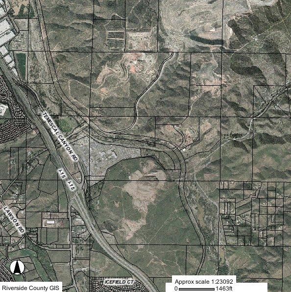
31 OWNER Corona Clay Company ASSESOR'S PARCEL NUMBER(S) , , , , SUPERVISORIAL DISTRICT SIZE OF PROPOSED PARK (acres) TYPE OF PARK CURRENT AMENITIES PENDING ENTITLEMENTS First 300 acres Motorcycles ATV Rock Crawling Motocross Track Motorcycle Trials Trail Riding Improved Camping Unimproved Camping Safety Training Old mine site, current has three test tracks for motorcycles CUP Test track for motorbikes,cup motorcycle test track, SMP00197R1- mining operation CURRENT ZONING M-M, M-R-A, M-R GENERAL PLAN DESIGNATION OS-MIN AGRICULTURAL PRESERVE No ELEVATION CHANGE Primarily in Cell Group "F" and "G" of the MSHCP calling for CONSERVATION CRITERIA conservation on the eastern portions of the site Burrowing Owl, Thread-leaved brodiaea, Davidson's saltscale, Parish's brittlescale, Smooth Tarplant, Round-leaved filaree, Coulter's goldfields, Little Mousetail, Munz's onion, San Diego ambrosia, Slender-Horned Spineflower, Many-stemmed dudleya, Spreading navarretia, California Orcutt grass, San PROTECTED SPECIES Miguel savory, Hammitt's clay-cress, Wright's trichocoronis WATER COURSE Adjacent to Temecula Creek TYPE OF TERRAIN Gently rolling to steep hills in the mined area. ACCESS TO AREA CAMPING AVAILABLE HIGH FIRE AREA FAULTS MT. PALOMAR ORD. 655 BUFFER AREAS CLOSEST RESIDENTIAL AREAS CODE VIOLATIONS ISSUES OF CONCERN Access off Temescal Canyon Road and Dawson Creek Road No Yes within 1/2 mile of unnamed fault for Elsinore Fault Zone Not applicable - 45 miles Buffered to the north and east by the La Sierra Landfill and the Lake Matthews Reserve. There is an industrial area to the west Residential areas are located to the southeast of the site in the Spanish Hills area and over a mile to the west on the west side of I-15. unapproved business, illegal dumping, illegal grading, uses w/o proper permits Current test tracks are operated by the motorcycle industry and they may not want the public/competition to see test vehicles Temescal Canyon
32
33 OPERATIONAL CONCEPTS The type of management and operation of an OHV park will either make it a success or doom it to continual problems. Prior to developing a park, a decision is needed as to how and who will ultimately construct the facility and manage it. There are three primary methods that will generate a built facility. The County could construct the facility itself; could contract for a turn-key development that a contractors builds to County specifications; or the County could have an operator build the facility. Likewise, the County could operate the facility itself; contract with an outside vendor to run a County operation; or have a third party operate the facility. The third party could be a for-profit operator, a non-profit organization, or a governmental entity other than the County. Each of these options leads to a different set of issues that must be evaluated before any OHV park can be opened. Regardless of which of the above management/operational scenarios are followed, the National Off-Highway Vehicle Conservation Council recommends that a program containing four equally important elements is necessary to assure long-term viability of an OHV park: engineering, education, enforcement and evaluation. Engineering The concept of using engineering or facility design to address environmental and social issues is commonly used in recreation management. The primary principle that must be constantly acknowledged is that when visitors come to an OHV park to have fun, they will have fun. If they can have fun within the designated design of the OHV park, they will; if not, they will still have fun, but in ways that may cause management and environmental problems. The ultimate facility must provide an opportunity for people to find a challenge in an appropriate manner. Trails should provide challenges by leaving obstacles in or near the trail or by building trails with higher levels of exposure. While each park may provide multiple opportunities for recreation, no one park will meet all recreational needs. The facilities that are built need to address the entire spectrum of OHV needs, from trails to motocross; hill climbs and rock crawling to sand dunes and camping options. Education Generally, people want to believe that most people want to do what is right. The problem is they may not know what that is. While the easy view may be that doing what is right is a matter of using common sense, experience has shown that the link between common sense and doing what is right is education. A basic premise is that educated riders are responsible riders, and responsible riders keep riding opportunities open and reduce impacts.
34 The value of information is dependent on how usable it is when received. It is important to provide information at the needed time and recognize that although the bulk of use may start at a local level, the facility is open and available to the larger community; the use pattern may evolve as the site becomes a destination for non-local riders. Enforcement Active and reasonable enforcement is critical to successful long-term management of OHV use. Enlightened enforcement methods assume that most people want to do what is right. Education should be stressed over citation. A review of the rules and firmly stating the needed corrective behavior with a warning is often far more effective and positive than a ticket, when an infraction is identified. Positive attitudes create positive programs, and the objective of enforcement is to obtain compliance with the rules. Evaluation Once the park is operational, it is necessary to effectively evaluate the effects of the recreational use on the facilities and the environment. It is equally important to evaluate the success of the programs from the perspective of the user and the effectiveness of the management. The evaluation or monitoring process can easily take on a life of its own and can consume a significant portion of the budget, if allowed to. An effective evaluation process must be as simple as possible. The results of the analysis must be documented and readily available to the agency staff and to the public.
35 RECOMMENDATONS The OHV Commission has completed its tasks as instructed by the Board of Supervisors: the identification of several candidate sites for use as off-highway vehicle parks, the extent and range of use for each candidate sites, and the Commission has provided advice to county staff and decision-makers. The Commission has performed these duties within its original time constraint and recommends that the following additional work be performed: 1. Evaluation of the suggested potential sites, to narrow the candidates to specific site recommendations. 2. Hold public hearings on recommended site(s) to identify potential issues of concerns. 3. Prepare an Environmental Impact Report on the selected site(s). 4. Develop a timeline for implementation of the final recommendations.
36
37
38
39
40
41
42
43
44
45
46
47
48
49
50
51
52
53
54
55
56
57
58
59
60
61
62
63
64
65
66
67
68
69
70
71
72
73
74
75
76
77
78
79
80
81
82
83
84
85
86
87
88
89
90
91
92
93
94
95
96
97
98
99
100
101
102
103
104
105
09 LBL Turkey Bay Off-Highway Vehicle Area Rules & Regulations
 09 LBL Turkey Bay Off-Highway Vehicle Area Rules & Regulations Revised 3-2009 ABOUT TURKEY BAY OHV AREA Turkey Bay Off-Highway Vehicle (OHV) Area is a designated area for OHV riding and camping. Turkey
CHAPTER 1 INTRODUCTION MORENO VALLEY GENERAL PLAN 1. INTRODUCTION. 1.1 What is a General Plan?
 1. INTRODUCTION 1.1 What is a General Plan? A General Plan is a comprehensive long-term strategy for the physical development of a city. It determines how land may be used and the infrastructure and public
RE: Access Fund Comments on Yosemite National Park Wilderness Stewardship Plan, Preliminary Ideas and Concepts
 September 30, 2016 Superintendent Yosemite National Park Attn: Wilderness Stewardship Plan P.O. Box 577 Yosemite, CA 95389 RE: Access Fund Comments on Yosemite National Park Wilderness Stewardship Plan,
MESA COUNTY DEPARTMENT OF PUBLIC WORKS Administration - Building - Engineering Road and Bridge Traffic - Planning - Solid Waste Management
 MESA COUNTY DEPARTMENT OF PUBLIC WORKS Administration - Building - Engineering Road and Bridge Traffic - Planning - Solid Waste Management 200 S. Spruce St. P.O. Box 20,000 Grand Junction, Colorado 81502-5022
Logo Department Name Agency Organization Organization Address Information 5700 North Sabino Canyon Road
 Logo Department Name Agency Organization Organization Address Information United States Forest Coronado National Forest 5700 North Sabino Canyon Road Department of Service Santa Catalina Ranger District
RECREATION. Seven issues were identified that pertain to the effects of travel management on outdoor recreation within portions of the project area.
 RECREATION Seven issues were identified that pertain to the effects of travel management on outdoor recreation within portions of the project area. OPPORTUNITIES FOR SOLITUDE / QUIET TRAILS. One attraction
FINAL TESTIMONY 1 COMMITTEE ON RESOURCES UNITED STATES HOUSE OF REPRESENTATIVES. July 13, 2005 CONCERNING. Motorized Recreational Use of Federal Lands
 FINAL TESTIMONY 1 STATEMENT OF DALE BOSWORTH CHIEF Of the FOREST SERVICE UNITED STATES DEPARTMENT OF AGRICULTURE Before the SUBCOMMITTEE ON FORESTS AND FOREST HEALTH And the SUBCOMMITTEE ON NATIONAL PARKS,
Daisy Dean Trail 628/619 ATV Trail Construction
 Background and Purpose and Need The Daisy Dean ATV Trail Construction Project is located in the Little Belt Mountains, Musselshell Ranger District, Lewis and Clark National Forest approximately 32 miles
Dumont Dunes Special Recreation Management Area (SRMA)
") Dumont Dunes Special Recreation Management Area (SRMA) RMA/RECREATION MANAGEMENT ZONE (RMZ) OBJECTIVE(S) DECISIONS Objective Statement: Designate this area as a Special Recreation Management Area. To manage
Dumont Dunes Special Recreation Management Area (SRMA) RMA/RECREATION MANAGEMENT ZONE (RMZ) OBJECTIVE(S) DECISIONS Objective Statement: Designate this area as a Special Recreation Management Area. To manage
RECREATION ACCESS AND COMMUNITY ENRICHMENT PLAN
 Template for facilitating Siskiyou County, the City of Yreka and the State of Jefferson in a RECREATION ACCESS AND COMMUNITY ENRICHMENT PLAN Access to the Mountains CREATING ACCESS TO PUBLIC AND PRIVATE
Proposed Action. Payette National Forest Over-Snow Grooming in Valley, Adams and Idaho Counties. United States Department of Agriculture
 United States Department of Agriculture Forest Service January 2012 Proposed Action Payette National Forest Over-Snow Grooming in Valley, Adams and Idaho Counties Payette National Forest Valley, Adams
13.1 REGIONAL TOURISM ISSUES AND SUMMARY OF FINDINGS
 13 REGIONAL TOURISM T he County of Mariposa s recreation needs and facilities fall within two categories: regional tourism and local recreation. This Element focuses on regional tourism issues related
Rule Governing the Designation and Establishment of All-Terrain Vehicle Use Trails on State Land
 Rule Governing the Designation and Establishment of All-Terrain Vehicle Use Trails on State Land 1.0 Authority 1.1 This rule is promulgated pursuant to 23 V.S.A. 3506. Section 3506 (b)(4) states that an
The Redondo Mesa study area is located east of the CNF within hilly terrain 9 miles west of Temecula.
 County of Riverside - PSEC Project General Habitat Assessment Appendix A Redondo Mesa Redondo Mesa The Redondo Mesa study area is located east of the CNF within hilly terrain 9 miles west of Temecula.
PURPOSE AND NEED. Introduction
 Public Scoping: Allocation of Recreation Capacity for Commercial Outfitter Guide Services on North Kruzof Island Trails (Kruzof Island Outfitter Guide) PURPOSE AND NEED Introduction The U.S. Department
SDTrucksprings. Indiana Off-roading/4x4 Guide Copyright 2015 We Specialize In:
 SDTrucksprings Indiana Off-roading/4x4 Guide Copyright 2015 We Specialize In: Helper Springs Air Bags Leaf Springs Body Lift Kits Coil Springs Timbren Kits Hellwig Springs Lift Blocks And More! Visit www.sdtrucksprings.com
Buford / New Castle Motorized Trail
 Buford / New Castle Motorized Trail Rifle Ranger District, White River National Forest Garfield County, Colorado Comments Welcome The Rifle Ranger District of the White River National Forest welcomes your
White Mountain National Forest Saco Ranger District
 United States Department of Agriculture Forest Service White Mountain National Forest 33 Kancamagus Highway Conway, NH 03818 Comm: (603) 447-5448 TTY: (603) 447-3121 File Code: 1950 Date: February 26,
Creating a User-Driven Long-Distance OHV Trail Through Partnering
 Joseph Raffaele Outdoor Recreation Planner U.S. Bureau of Land Management Yuma, Arizona Creating a User-Driven Long-Distance OHV Trail Through Partnering BLM is a multiple-use land management agency within
MONTEREY REGIONAL AIRPORT MASTER PLAN TOPICAL QUESTIONS FROM THE PLANNING ADVISORY COMMITTEE AND TOPICAL RESPONSES
 MONTEREY REGIONAL AIRPORT MASTER PLAN TOPICAL QUESTIONS FROM THE PLANNING ADVISORY COMMITTEE AND TOPICAL RESPONSES Recurring topics emerged in some of the comments and questions raised by members of the
Preferred Recreation Recommendations Stemilt-Squilchuck Recreation Plan March 2018
 Preferred Recreation Recommendations Stemilt-Squilchuck Recreation Plan March 2018 Below are the recommended recreation ideas and strategies that package together the various recreation concepts compiled
Theme: Predominately natural/natural appearing; rustic improvements to protect resources. Size*: 2,500 + acres Infrastructure**:
 Recreation Opportunity Spectrum (ROS) Classes The Recreation Opportunity Spectrum (ROS) provides a way to describe the variations in the degree of isolation from the sounds and influences of people, and
The Lake Mathews study area is located approximately 1.5 miles east of Lake Mathews, and approximately 0.2 mile north of the Colorado River Aqueduct.
 County of Riverside - PSEC Project General Habitat Assessment Appendix A Lake Mathews Lake Mathews The Lake Mathews study area is located approximately 1.5 miles east of Lake Mathews, and approximately
Section 61 Recreational Vehicle Park / Campground (Bylaw No. 2012/10)
") Part 7 General Regulations Section 61 Recreational Vehicle Park / Campground (Bylaw No. 2012/10) 61.1 A comprehensive site plan shall be provided to the satisfaction of the Development Authority that shows
Part 7 General Regulations Section 61 Recreational Vehicle Park / Campground (Bylaw No. 2012/10) 61.1 A comprehensive site plan shall be provided to the satisfaction of the Development Authority that shows
Understanding user expectations And planning for long term sustainability 1
 Understanding user expectations And planning for long term sustainability 1 What is a natural surface trail? It can be as simple has a mineral soil, mulched or graveled pathway, or as developed as elevated
Mt. Hood National Forest
 United States Department of Agriculture Forest Service Mt. Hood National Forest Zigzag Ranger District 70220 E. Highway 26 Zigzag, OR 97049 503-622-3191 Fax: 503-622-5622 File Code: 1950-1 Date: June 29,
Vista Field Airport. Master Plan Update. February, Prepared for: Port of Kennewick One Clover Island Kennewick, Washington
 Vista Field Airport February, 2006 Prepared for: Port of Kennewick One Clover Island Kennewick, Washington 99336 Prepared by: J-U-B ENGINEERS, Inc. 2810 W. Clearwater Avenue, Suite 201 Kennewick, Washington
ROAD AND TRAIL PROJECT APPROVAL
 ROAD AND TRAIL PROJECT APPROVAL www.marincountyparks.org Marin County Parks, 3501 Civic Center Dr, Suite 260, San Rafael, CA 94903 DATE: July 12, 2017 PRESERVE: Gary Giacomini Open Space Preserve PROJECT:
Alternative Highest & Best Use Analysis Boutique Hotel
 Alternative Highest & Best Use Analysis In response to numerous comments received from the public, as well as issues raised by the CCC in the Appeal Staff Report Substantial Issue Determination, the following
ORDINANCE NO. JACKSON TOWNSHIP, CAMBRIA COUNTY
 ORDINANCE NO. JACKSON TOWNSHIP, CAMBRIA COUNTY AN ORDINANCE OF THE TOWNSHIP OF JACKSON AMENDING SECTIONS OF THE JACKSON TOWNSHIP ZONING ORDINANCE AS FOLLOWS: PROVIDING NEW DEFINITIONS OF CAMPGROUNDS, CAMPSITE,
Tahoe National Forest Over-Snow Vehicle Use Designation
 Tahoe National Forest Over-Snow Vehicle Use Designation USDA Forest Service Tahoe National Forest February 20, 2015 Introduction The Forest Service, U.S. Department of Agriculture will prepare an Environmental
Chatsworth Branch Library Devonshire Street, Chatsworth, CA Thursday, November 16, :00-8:00 pm
 Chatsworth Branch Library 21052 Devonshire Street, Chatsworth, CA 91311 Thursday, November 16, 2017 6:00-8:00 pm Project Team County of Los Angeles Department of Parks and Recreation Kathline King Chief
Tracy Ridge Shared Use Trails and Plan Amendment Project
 Tracy Ridge Shared Use Trails and Plan Amendment Project Scoping Document Forest Service Allegheny National Forest Bradford Ranger District McKean, County, Pennsylvania In accordance with Federal civil
Non-motorized Trail Plan & Proposal. August 8, 2014
 Town of Star Valley Ranch, Wyoming and the Star Valley Ranch Association in partnership with the USDA Forest Service, Bridger-Teton National Forest, Greys River Ranger District Non-motorized Trail Plan
The San Diego Region s Air Transportation Future
 The San Diego Region s Air Transportation Future June 22, 2006 1 Ryan N. Hall, Airport System Planner II San Diego County Regional Airport Authority Presentation Overview 1. The law 2. The ballot measure
Stevenson Ranch Library The Old Road, Stevenson Ranch, CA Thursday, November 9, :00-8:00 pm
 Stevenson Ranch Library 25950 The Old Road, Stevenson Ranch, CA 91381 Thursday, November 9, 2017 6:00-8:00 pm Project Team County of Los Angeles Department of Parks and Recreation Kathline King Chief of
Section II. Planning & Public Process Planning for the Baker/Carver Regional Trail began in 2010 as a City of Minnetrista initiative.
 Section II Planning & Public Process Planning for the began in 2010 as a City of initiative. city staff began discussions with the Park District on the possibility of a north/south regional trail connection
Bradley Brook Relocation Project. Scoping Notice. Saco Ranger District. United States Department of Agriculture Forest Service
 Bradley Brook Relocation Project United States Department of Agriculture Forest Service Scoping Notice White Mountain National Forest February 2011 For Information Contact: Jenny Burnett White Mountain
Airport Planning Area
 PLANNING AREA POLICIES l AIRPORT Airport Planning Area LOCATION AND CONTEXT The Airport Planning Area ( Airport area ) is a key part of Boise s economy and transportation network; it features a multi-purpose
National Wilderness Steering Committee
 National Wilderness Steering Committee Guidance White Paper Number 1 Issue: Cultural Resources and Wilderness Date: November 30, 2002 Introduction to the Issue Two of the purposes of the National Wilderness
Table of Contents. page 3 Long term Goals Project Scope Project History. 4 User Groups Defined Trail Representative Committee. 5 Trail Users Breakdown
 Launched April 27th, 2010 1 Table of Contents page 3 Long term Goals Project Scope Project History 4 User Groups Defined Trail Representative Committee 5 Trail Users Breakdown 13 Trail Users Desires 16
Longmont to Boulder Regional Trail Jay Road Connection DRAFT FINAL REPORT
 Longmont to Boulder Regional Trail Jay Road Connection DRAFT FINAL REPORT December 2018 Project Summary Boulder County, Colorado, in partnership with the City of Boulder, is evaluating options for multi-use
COASTAL CONSERVANCY. Staff Recommendation September 22, 2011 BAY AREA RIDGE TRAIL: HOOD MOUNTAIN TO HIGHWAY 12
 COASTAL CONSERVANCY Staff Recommendation September 22, 2011 BAY AREA RIDGE TRAIL: HOOD MOUNTAIN TO HIGHWAY 12 File No. 11-039-001 Project Manager: Betsy Wilson RECOMMENDED ACTION: Authorization to disburse
FEASIBILITY CRITERIA
 This chapter describes the methodology and criteria used to evaluate the feasibility of developing trails throughout the study areas. Land availability, habitat sensitivity, roadway crossings and on-street
At the time, the portion of the line through Eagle County remains wholly under the ownership of Union Pacific Railroad (UP).
.") Chapter 5 The Railroad Corridor as a Trail Corridor The intent of this chapter is to identify how the rail corridor, if available for lease or purchase in all or part, could be incorporated into the core
Chapter 5 The Railroad Corridor as a Trail Corridor The intent of this chapter is to identify how the rail corridor, if available for lease or purchase in all or part, could be incorporated into the core
National Park Service Wilderness Action Plan
 National Park Service U.S. Department of the Interior National Park Service Wilderness Action Plan National Wilderness Steering Committee National Park Service "The mountains can be reached in all seasons.
SUMMER VILLAGE OF SILVER SANDS. Municipal Development Plan
 SUMMER VILLAGE OF SILVER SANDS Municipal Development Plan Bylaw 253-2014 Adopted August 22, 2014 Summer Village of Silver Sands Municipal Development Plan Bylaw No. 253-2014 Page 2 1 INTRODUCTION 1.1 SETTING
SDTrucksprings. Arkansas Off-roading/4x4 Guide Copyright 2015 We Specialize In:
 SDTrucksprings Arkansas Off-roading/4x4 Guide Copyright 2015 We Specialize In: Helper Springs Air Bags Leaf Springs Body Lift Kits Coil Springs Timbren Kits Hellwig Springs Lift Blocks And More! Visit
Colorado s forests are slated to lose thousands of miles of roads through the new OHV Route Designation process. DON T LET IT HAPPEN!
 Colorado s forests are slated to lose thousands of miles of roads through the new OHV Route Designation process. DON T LET IT HAPPEN! This packet identifies many roads that you may lose if you don t act.
HIGHWAY 17 WILDLIFE and REGIONAL TRAIL CROSSINGS
 HIGHWAY 17 WILDLIFE and REGIONAL TRAIL CROSSINGS Agenda and Meeting Format 7:00-7:15 Welcome 7:15-8:00 Presentation 8:00-8:30 Open House 8:30 Recap 9:00 Conclusion 2 Meeting Goals: Introduce the project
Executive Summary. MASTER PLAN UPDATE Fort Collins-Loveland Municipal Airport
 Executive Summary MASTER PLAN UPDATE Fort Collins-Loveland Municipal Airport As a general aviation and commercial service airport, Fort Collins- Loveland Municipal Airport serves as an important niche
MANAGEMENT FACTORS TO CONSIDER REGARDING CONCURRENT TRACKED OHV USE ON GROOMED SNOWMOBILE TRAILS
 MANAGEMENT FACTORS TO CONSIDER REGARDING CONCURRENT TRACKED OHV USE ON GROOMED SNOWMOBILE TRAILS By Trails Work Consulting For the American Council of Snowmobile Associations June 2015 MANAGEMENT FACTORS
Project Deliverable 4.1.3d Individual City Report - City of La Verne
 Pomona Valley ITS Project Project Deliverable 4.1.3d Individual City Report - City of La Verne Prepared by: April 19, 2002 099017000.1 Copyright 2002, Kimley-Horn and Associates, Inc TABLE OF CONTENTS
Emily to Blind Lake Trail PROPOSED TRAIL DEVELOPMENT APPLICATION SUMMARY
 Emily to Blind Lake Trail PROPOSED TRAIL DEVELOPMENT APPLICATION SUMMARY Township 137 Range 26 (Fairfield Township) sections 2 & 3 Township 138 Range 26 (City of Emily) sections 27, 34, 35, & 36 Township
Kelly Motorized Trails Project Proposed Action
 Kelly Motorized Trails Project Proposed Action November 28, 2011 The Flagstaff Ranger District of the Coconino National Forest is seeking public input on the proposed Kelly Motorized Trails Project (formerly
Final Recreation Report. Sunflower Allotment Grazing Analysis. July 2015
 Final Recreation Report Sunflower Allotment Grazing Analysis July 2015 Table of Contents Introduction... 3 Affected Environment... 3 Four Peaks Wilderness Area... 3 Dispersed Recreation... 3 Environmental
TABLE COUNTY REGIONAL PARKS AND COMMUNITY PARKS IN THE DESERT REGION
 The purpose of this Section is to identify existing recreation opportunities within the Project area, analyze potential impacts to recreation associated with the development of the proposed Project, and
Continental Divide National Scenic Trail Legislative History and Planning Guidance
 Continental Divide National Scenic Trail Legislative History and Planning Guidance Legislation, Policy, and Direction Regarding National Scenic Trails The National Trails System Act, P.L. 90-543, was passed
FRENCH VALLEY AIRPORT (F70) Sky Canyon Dr. Murrieta, CA. Phone: Riverside FAA FSDO Complaint Line: (951)
 Sky Canyon Dr. Murrieta, CA. Phone: Riverside FAA FSDO Complaint Line: (951)") FRENCH VALLEY AIRPORT (F70) 37600 Sky Canyon Dr. Murrieta, CA Phone: 951-600-7297 Riverside FAA FSDO Complaint Line: (951) 276-6701 Visit the F70 website for additional information regarding the airport
FRENCH VALLEY AIRPORT (F70) 37600 Sky Canyon Dr. Murrieta, CA Phone: 951-600-7297 Riverside FAA FSDO Complaint Line: (951) 276-6701 Visit the F70 website for additional information regarding the airport
RV LOT PROCEDURE. RV1.4 Special circumstances (e.g., hardship, military service) will be addressed on an individual basis.
 will be addressed on an individual basis.") RV1. Scope RV LOT PROCEDURE RV1.1 This procedure has been established to provide a methodical approach for assigning parking space in the RV Lot to Fairfield residents for their recreational vehicles only
RV1. Scope RV LOT PROCEDURE RV1.1 This procedure has been established to provide a methodical approach for assigning parking space in the RV Lot to Fairfield residents for their recreational vehicles only
Parkland County Municipal Development Plan Amendment Acheson Industrial Area Structure Plan
 Parkland County Municipal Development Plan Amendment Acheson Industrial Area Structure Plan New Plan Acheson Industrial Area Structure Plan Amendment Parkland County Municipal Development Plan Board Reference
David Johnson. Tom, Attached please find the final scoping letter and figures for your review. David
 David Johnson From: Sent: To: Cc: Subject: Attachments: David Johnson Tuesday, April 12, 2011 4:33 PM Thomas Malecek Dave Dyer; Jason Marks (jmarks@segroup.com) VWC Scoping Letter
Bloor Street West Rezoning Application for a Temporary Use By-law Final Report
 STAFF REPORT ACTION REQUIRED 3741 3751 Bloor Street West Rezoning Application for a Temporary Use By-law Final Report Date: June 12, 2007 To: From: Wards: Reference Number: Etobicoke York Community Council
TOWN OF WARWICK LOCAL LAW NO. 4 OF 2015 A LOCAL LAW TO AMEND THE ZONING LAW
 Local Law Filing NEW YORK STATE DEPARTMENT OF STATE 162 WASHINGTON AVENUE ALBANY, NY 12231 (Use this form to file a local law with the Secretary of State.) Text of law should be given as amended. Do not
CITY OF PALMDALE LOS ANGELES COUNTY, CALIFORNIA RESOLUTION NO. CC
 CITY OF PALMDALE LOS ANGELES COUNTY, CALIFORNIA RESOLUTION NO. CC 2010-087 A RESOLUTION OF THE CITY COUNCIL OF THE CITY OF PALMDALE, CALIFORNIA, APPROVING SPECIFIC PLAN AMENDMENT 10-01, AMENDING THE PALMDALE
Business Item No XXX. Proposed Action That the Metropolitan Council approve the Coon Creek Regional Trail Master Plan.
 Business Item No. 2015-XXX Metropolitan Parks and Open Space Commission Meeting date: July 7, 2015 For the Community Development Committee meeting of July 20, 2015 For the Metropolitan Council meeting
PROPOSED PARK ALTERNATIVES
 8 Chimne y Rock State Park M a ster Pl an 2011 PROPOSED PARK ALTERNATIVES Introduction Three different park development concepts were prepared and presented to the citizens of North Carolina through a
Westover Metropolitan Airport Master Plan Update
 Westover Metropolitan Airport Master Plan Update June 2008 INTRODUCTION Westover Metropolitan Airport (CEF) comprises the civilian portion of a joint-use facility located in Chicopee, Massachusetts. The
PROPOSED ACTION South 3000 East Salt Lake City, UT United States Department of Agriculture
 United States Department of Agriculture Forest Service Uinta-Wasatch-Cache National Forest Salt Lake Ranger District 6944 South 3000 East Salt Lake City, UT 84121 801-733-2660 File Code: 1950/2300 Date:
Proposal to Redevelop Lower Kananaskis River-Barrier Lake. Bow Valley Provincial Park. Frequently Asked Questions
 Proposal to Redevelop Lower Kananaskis River-Barrier Lake Bow Valley Provincial Park Frequently Asked Questions What is being proposed? What are the details of the proposal? Where is the project area located?
b. Minimum Site Area. Recreational vehicle parks shall be located on a parcel of land not less than 3 acres in area.
 6450 RECREATIONAL VEHICLE PARK REGULATIONS 6450 TITLE AND PURPOSE. The provisions of Section 6450 through 6499, inclusive, shall be known as the Recreational Vehicle Park Regulations. The purpose of these
White Mountain National Forest Saco Ranger District
 United States Department of Agriculture Forest Service White Mountain National Forest Saco Ranger District 33 Kancamagus Highway Conway, NH 03818 Comm: (603) 447-5448 TTY: (603) 447-3121 File Code: 1950
EAST DON TRAIL ENVIRONMENTAL ASSESSMENT. Community Liaison Committee Meeting #3 July 15, :30 to 8:30 pm Flemingdon Park Library
 EAST DON TRAIL ENVIRONMENTAL ASSESSMENT Community Liaison Committee Meeting #3 July 15, 2013 6:30 to 8:30 pm Flemingdon Park Library Agenda 1. Welcome 2. Housekeeping and Updates a) Housekeeping b) CLC
Appendix D Project Newsletters. Tacoma Narrows Airport. Master Plan Update
 Appendix D Project Newsletters Tacoma Narrows Airport Master Plan Update This appendix contains the newsletters distributed throughout the project. These newsletters provided updates and information on
CODE OF CONDUCT. Corporate Compliance 10.9 Effective: 12/17/13 Reviewed: 1/04/17 Revised: 1/04/17
 Corporate Compliance 10.9 Effective: 12/17/13 Reviewed: 1/04/17 Revised: 1/04/17 1. POLICY This policy defines the commitment that PHI Air Medical, L.L.C has to conducting our activities in full compliance
NON-MOTORIZED TRAIL RECREATION IN IDAHO
 Idaho Department of Parks and Recreation 5657 Warm Springs Avenue, Boise, Idaho 83716 Tel 208.334.4199 www.parksandrecreation.idaho.gov NON-MOTORIZED TRAIL RECREATION IN IDAHO 2016 This report contains
City of Durango 5.8 FUNDING TRAILS DEVELOPMENT
 5.8 FUNDING TRAILS DEVELOPMENT The City has been successful in establishing dedicated local funding sources as well as applying for grants to develop the City s trail system, having received nearly $2.4
IAGSA Survey Contract Annex
 Notice to Users This document will be expanded and revised from time to time without notice. Users may obtain the most current version from IAGSA s web site at: www.iagsa.ca The Safety Policy Manual referred
SOUTH INTERCHANGE AREA
 Santaquin City General Plan 1 Location and Characteristics The South Interchange Area of Santaquin is located west of Interstate 15 and south of 500 South (Figure 1). It includes properties already annexed
EXECUTIVE SUMMARY PROGRAM DEVELOPMENT REPORT PURPOSE EXISTING SETTING EXPANDING PARKLAND
 EXECUTIVE SUMMARY PROGRAM DEVELOPMENT REPORT PURPOSE As the culmination of the first phase of the master planning process, this Program Development Report creates the framework to develop the Calero County
Recreation Opportunity Spectrum for River Management v
 Recreation Opportunity Spectrum for Management v. 120803 Introduction The following Recreation Opportunity Spectrum (ROS) characterizations and matrices mirror the presentation in the ROS Primer and Field
Proposed Peninsula Bay Bike Track Development
 Proposed Peninsula Bay Bike Track Development May 2018 BACKGROUND The area of land at the northern extreme of Wanaka's Peninsula Bay development (Lot 923 DP 501325), currently owned by Infinity Investment
BAYFIELD COUNTY FOREST COMPREHENSIVE LAND USE PLAN TABLE OF CONTENTS CHAPTER 700 ACCESS MANAGEMENT ROADS AND TRAILS
 BAYFIELD COUNTY FOREST COMPREHENSIVE LAND USE PLAN TABLE OF CONTENTS CHAPTER 700 ACCESS MANAGEMENT ROADS AND TRAILS 700 Access Management/Roads and Trails 3 700.1 History 3 700.2 Current Status 3 700.3
The Roots of Carrying Capacity
 1 Applying Carrying Capacity Concepts in Wilderness 1872 1964...shall be preserved for the use & enjoyment of the American people...in such manner as will leave them unimpaired for future generations...
Northeast Quadrant Distinctive Features
 NORTHEAST QUADRANT Northeast Quadrant Distinctive Features LAND USE The Northeast Quadrant includes all the area within the planning area that is east of Interstate 5 and to the north of State Route 44.
CHAPTER 1 EXECUTIVE SUMMARY
 CHAPTER 1 EXECUTIVE SUMMARY 1 1 EXECUTIVE SUMMARY INTRODUCTION William R. Fairchild International Airport (CLM) is located approximately three miles west of the city of Port Angeles, Washington. The airport
General Rules for Use of Lands Managed by the. Middle Peninsula Chesapeake Bay Public Access Authority
 General Rules for Use of Lands Managed by the Middle Peninsula Chesapeake Bay Public Access Authority As a visitor to lands managed by the Middle Peninsula Chesapeake Bay Public Access Authority (PAA),
2.0 Physical Characteristics
 _ 2.0 Physical Characteristics 2.1 Existing Land Use for the Project The site is comprised of approximately 114 acres bounded by Highway 101 to the north, the existing town of Los Alamos to the east, State
County of Riverside - PSEC Project General Habitat Assessment Appendix A
 County of Riverside - PSEC Project General Habitat Assessment Appendix A Glen Avon Glen Avon The Glen Avon study area is located north of State Route 60 in the Jurupa Mountains, approximately 1 mile south
April 10, Mark Stiles San Juan Public Lands Center Manager 15 Burnett Court Durango, CO Dear Mark,
 Mark Stiles San Juan Public Lands Center Manager 15 Burnett Court Durango, CO 81301 Dear Mark, We are pleased to offer the following comments on the draft San Juan Public Lands Center management plans
1803 West Hwy 160 Monte Vista, CO (719) TTY (719)
 TTY (719)") USDA Forest Service Rio Grande National Forest http://www.fs.fed.us/r2/riogrande 1803 West Hwy 160 Monte Vista, CO 81144 (719)852-5941 TTY (719)852-6271 USDI Bureau of Land Management San Luis Valley Center
USDA Forest Service Rio Grande National Forest http://www.fs.fed.us/r2/riogrande 1803 West Hwy 160 Monte Vista, CO 81144 (719)852-5941 TTY (719)852-6271 USDI Bureau of Land Management San Luis Valley Center
5.0 OUTDOOR RECREATION OPPORTUNITIES AND MANAGEMENT
 5.0 OUTDOOR RECREATION OPPORTUNITIES AND MANAGEMENT 5.1 Introduction This section describes the range of recreational activities that currently take place in Marble Range and Edge Hills Parks, as well
COASTAL CONSERVANCY. Staff Recommendation December 2, 2004 COYOTE HELLYER COUNTY PARK BAY AREA RIDGE TRAIL
 COASTAL CONSERVANCY Staff Recommendation December 2, 2004 COYOTE HELLYER COUNTY PARK BAY AREA RIDGE TRAIL File No. 04-057 Project Manager: Amy Hutzel RECOMMENDED ACTION: Authorization to disburse up to
Recommendation to Include Specific Safety Requirements in Geophysical Survey Contracts & Proposed Survey Contract Annex
 INTERNATIONAL AIRBORNE GEOPHYSICS SAFETY ASSOCIATION Recommendation to Include Specific Safety Requirements in Geophysical Survey Contracts & Proposed Survey Contract Annex Notice to Users This document
With the first portion of this process complete, we anticipate the general timeline for the remainder of the process to be:
 THE CITY OF FIRE RESCUE E D M O N T O N FIRE RESCUE SERVICES 10351 96 Street Edmonton, Alberta T5H 2H5 April 19, 2013 Dear Rossdale residents: As many of you know, Fire Rescue Services is currently in
DATE: 23 March, 2011 TO: Communities FROM: BlazeSports America. RE: Accessible Trails Checklist 1
 M E M O R A N D U M DATE: 23 March, 2011 TO: Communities FROM: BlazeSports America RE: Accessible Trails Checklist 1 The purpose of the Accessible Trails Checklist (below) is to help the community review
Lecture 08, 22 Sep 2003 Role Playing. Conservation Biology ECOL 406R/506R University of Arizona Fall Kevin Bonine
 Lecture 08, 22 Sep 2003 Role Playing Conservation Biology ECOL 406R/506R University of Arizona Fall 2003 Kevin Bonine 1. Role Playing Exercise 2. Exam Wed -group portion outside - ~40 minutes individual,
F. Forest Recreation Management
 F. Forest Recreation Management F.1) Park and Recreation Management F.1.A. Program Overview. The park and recreation program has been in existence since 1980. With ever increasing outdoor recreation demands
8 CROSS-BOUNDARY AGREEMENT WITH BRAMPTON TRANSIT
 8 CROSS-BOUNDARY AGREEMENT WITH BRAMPTON TRANSIT The Transportation Services Committee recommends the adoption of the recommendations contained in the following report dated May 27, 2010, from the Commissioner
Coronado National Forest Santa Catalina Ranger District
 United States Department of Agriculture Forest Service Coronado National Forest Santa Catalina Ranger District File Code: 1950 Date: October 14, 2015 Dear Interested Party: The Santa Catalina Ranger District