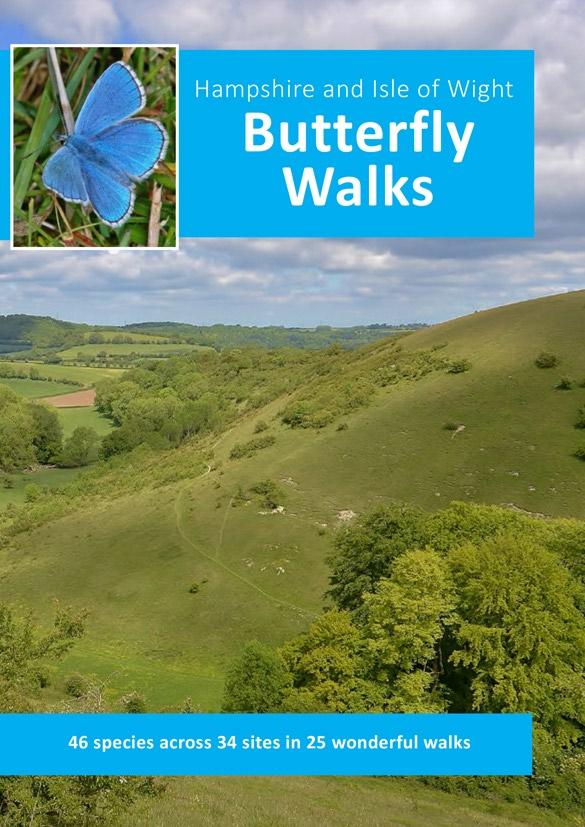
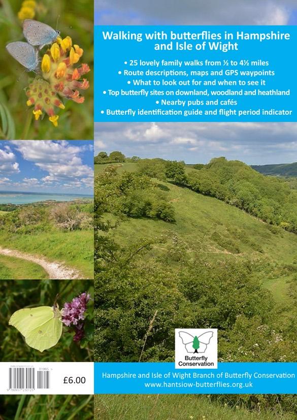
Hampshire and Isle of Wight Butterfly Walks
|
|
|
- Brett Freeman
- 5 years ago
- Views:
Transcription
1

2


3 Hampshire and Isle of Wight Butterfly Walks By Kevin Freeborn and shley Whitlock Contents Preface 3 Walking with butterflies 4 Butterfly Identification Skippers 6 Whites 7 Hairstreaks, Coppers and Blues 8 Metalmarks and ristocrats 10 Fritillaries 11 Browns 12 Walks 1. Magdalen Hill Down Bentley Station Meadow and Lodge Inclosure Yew Hill Silchester Common and Pamber Forest Yateley Common Butter Wood bbotts Wood Inclosure Shipton Bellinger Broughton Down Stockbridge Down Cowley s Copse, Bentley Wood Pitt Down and West Wood Noar Hill Old Winchester Hill NNR Butser Hill NNR and Ramsdean Down Whiteley Pastures Havant Thicket Portsdown Hill Martin Down NNR Pignal and Ramnor Inclosures Hawkhill Inclosure and Beaulieu Heath Walter s Copse and Newtown Meadows Brook, Compton and fton Downs Tennyson Down Bonchurch Down and Wheeler s Bay 62 Butterfly flight periods 64 Check list of sites and butterflies inside back cover 1

4 First published 2016 Hampshire and Isle of Wight Branch Butterfly Conservation, Walks devised by shley Whitlock and Kevin Freeborn Copyright text by Kevin Freeborn, 2016 Photographs shley Whitlock. Except scenes on pp22, 30 and 40 Kevin Freeborn. Back cover Brimstone, pp9 and 10 Chalkhill Blue, 13 Ringlet and Meadow Brown, 29 Blackthorn, 30 Dark Green Fritillary, 38 Cowslips and 49 Broom Dan Powell. Scene p16 Jayne Chapman Maps by Kevin Freeborn, based on Open Street Map Open Street Map contributors Designed by Dan Powell. Illustrations by Rosemary Powell Printed by Better Printing, Southampton. ISBN The Hampshire and Isle of Wight Branch of Butterfly Conservation is grateful to the Bentley Wood Charitable Trust, Forestry Commission England, Hampshire County Council, Hampshire and Isle of Wight Wildlife Trust, National Trust, and Natural England for maintaining the nature reserves visited in this guide and for safeguarding these very special places of wildlife interest. The authors would like to thank Cheryl and Kelvin Richards and Juliet Bloss for checking some of the routes; and to Cheryl, Juliet and Clive Wood for their assistance in proofreading the text. Front cover image: donis Blue; Ramsdean Down from Butser Hill, walk 15 Back cover image: Small Blue; Tennyson Down; Brimstone ll rights reserved. No part of this publication may be reproduced or transmitted in any form or by any means, electronic or mechanical, including photocopying, recording, or any information storage or retrieval system, without prior written permission from the publisher. This publication has been produced with care to ensure accuracy of the routes and associated information. Hampshire and Isle of Wight Branch of Butterfly Conservation cannot accept responsibility for errors, omissions and changes in the details presented. While the butterfly walks described use public rights of way, open access land and permissive paths normally open to the public, the countryside is not static and landowners may temporarily divert paths or close access for a designated period. If you find an inaccuracy in the book, please contact Butterfly Walks via the Branch website. 2

5 Preface Butterfly sightings cannot be entirely guaranteed. Seeing all 46 butterflies known to breed in Hampshire and Isle of Wight is certainly no exception. nd where would the fun be if it were? But armed with this guide and given some favourable weather, and a good pinch of luck, the odds in this captivating pastime of chance should be tipped in your favour. The walks in this guide visit 34 of the best butterfly sites across both counties. Compiled between pril and September 2015, shley and I have walked every route many more than once, and many of the sites are known to us from visits since the early 1980s. We have seen all the species listed for each place and there is no reason why you cannot too. On the whole these are reasonably gentle, family-friendly short walks, so pick a good weather day and enjoy an unhurried time and some splendid scenery amid the chalk downs, sandy heaths, broadleaved woodland and remnant meadows in these special places of butterfly interest across Hampshire and Isle of Wight. One day while compiling the guide, I was wandering in Cowley s Copse (Eastern Clearing), Bentley Wood, in June, wanting to see Small Pearl-bordered Fritillary. Having no luck, I sat on a bench to take a drink and ponder the afternoon s disappointment. fter a while, as I was stowing my flask back in my rucksack, two of them suddenly appeared dancing in the air beside me. So walk slowly and patiently. Stop regularly. Let the butterflies come to you. Stay vigilant. Every now and again allow for a modicum of disappointment and, during the course of the season, this should be more than offset by the rich rewards of some beautiful butterfly moments. Kevin Freeborn, March
6 Walking with Butterflies The walks described in this book follow public rights of way and/or lie across land where public access is usually permitted. Some of the routes present options for shorter circuits or longer walks. They act as an introduction to each site. Once familiar, give full rein to your natural curiosity for further exploration of other paths at each place. Choose fine weather for going on a walk. Generally speaking, butterflies will be more active in sunny and warm conditions. On windy days seek out the more sheltered spots. s spring and summer progress, different species will be on the wing, so check the guide to adult flight periods on page 64; annual variation in adult populations is entirely typical at any site, and you may expect variation from one site to another across the region. If you see a butterfly not on the check list (see inside back cover) please do report your sighting to the Branch at Follow the countryside code (Natural England) Consider the local community and other people enjoying the outdoors Leave gates and property as you find them Leave no trace of your visit and take your litter home with you Keep dogs under effective control Plan ahead and be prepared Follow advice and local signs Clothing and footwear Brambles, nettles, grass cuts and insect bites especially ticks associated with Lyme disease, found in bracken and long grass mean that shorts are not necessarily a wise option, even on the warmest of days. Sensible footwear is always advisable. Optical aids Bringing binoculars has its advantages, and not just for scanning tree tops for the more elusive species such as Purple Emperor, Purple Hairstreak or Brown Hairstreak. Gaining a close-up view can aid the identification or sexing of a butterfly and can permit observation without the need to disturb it through trampling, casting a shadow or the inevitable noise of close proximity. 4

7 Photography Photographing butterflies adds interest and challenge to a walk. Sharing the best images on the Branch website or on social media is a pleasurable and informative après-walk activity. Records If you don t already do it, start recording your butterfly sightings. The best method is to keep a check-list tally on each walk and then enter your observations on Living Record, see Once you have an account on this website you can log all your sightings for anywhere in the UK. Butterfly Conservation s county recorders are able to access this data so that your records can aid the work of the Branch and BC nationally: the more recorders and locations for which sightings are entered, the richer the data available. Try Butterfly Conservation s butterfly recording app, irecord Butterflies, which is easy to use and has a gallery to aid identification. Volunteering Many of the sites visited in this guide are local nature reserves, dependent upon voluntary help to maintain habitats and raise funds to support conservation activities. Do please consider becoming a volunteer to help sustain these beautiful pockets of countryside. See details on the Branch website for opportunities to join work parties at Magdalen Hill Down, Yew Hill or Bentley Station Meadow. Do support other local conservation organisations, too. Membership Membership of Butterfly Conservation s Hampshire and Isle of Wight Branch is a vital means of supporting the work of safeguarding butterflies and their habitats. Through its various events, field trips and work parties, the Branch is working tirelessly to seek new ways to engage existing members and to recruit new ones. Do please spread the word to family, friends and colleagues and encourage them to join the branch by visiting the main Butterfly Conservation website: 5


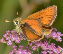
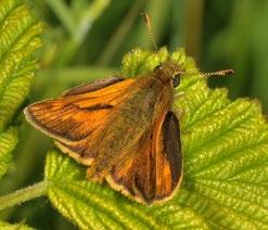
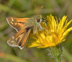
8 Skippers Small Skipper Essex Skipper Silver-spotted Skipper Large Skipper Dingy Skipper Grizzled Skipper 6


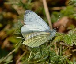
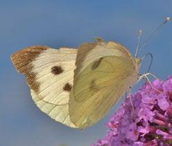

9 Whites Clouded Yellow Brimstone Large White Small White Green-veined White Orange-tip 7
10 Walk 1 Magdalen Hill Down Owned by BC since 1989, the original reserve has been extended through acquisition of adjacent land in 1997 and 2004 to create 100+ acres of magnificent chalk grassland. broad ridge of chalk extending east from Winchester at the western end of the South Downs, Magdalen Hill Down is a surviving piece of traditional sheep-grazed downland that once surrounded Hampshire s county town. The reserve comprises three distinct areas. There s the Original reserve, taken in between waypoints C and F, of steep-sided unimproved grassland; this was choked with scrub when BC bought the site in 1989 and tireless work since, cutting back and managing the hawthorn, has returned the hillside to flower-rich downland. The Extension lies to the east of the Original reserve and is overlooked at waypoint and circumnavigated between and C. This was ploughed and intensively farmed after World War II and its remarkable transformation by BC since 1997, patiently restored with carefully sown native wildflower seed mixes, is a conservation triumph. The carpet of yellow Cowslips is a splendid sight in spring. Magdalen Hill Down North is the third area, lying between the Original reserve and the lresford Road, and, sown like the Extension, is being restored to wonderful flower-filled grassland habitat. In a national context this is a flagship reserve for BC. The Walk Cross lresford Road and head up the track opposite passing the stonemason s yard. Go round the vehicle gate halfway up and at the top pass the reserve noticeboard (right) to reach a junction of tracks in front of a stile () overlooking the Extension part of the site. Before the stile turn left. Walk around the perimeter of the reserve, initially with the cemetery on the left. t the end of the top section bear right with a wire fence (right) and continue to follow the reserve boundary, soon descending to the bottom corner (B). Follow the boundary path as it turns right. Later, climb a stile on the right and follow a field-edge path left, gradually ascending to a line of trees ahead. Here turn right and walk up to the kissing-gate (C). 14

, through which take a detour along the sinuous chalk scrape to arrive at a kissing-gate giving on to a surfaced path.")

11 Go through to the Original reserve. In a few paces turn left, dipping steeply to find a crossing path emerging from the left-hand hedge. Turn right, contouring along the bottom of the down. Cross a stile and continue ahead, the main road screened by a dense hedge to the left. fter a path enters the reserve from the left, the way begins to ascend to ultimately intercept a wire fence. Here turn left to reach a small stockade and a pair of kissing-gates (D). Turn right after the second gate and pass through a third kissing-gate immediately ahead, following a fence on the right. Eventually this leads to another kissing-gate (E), through which take a detour along the sinuous chalk scrape to arrive at a kissing-gate giving on to a surfaced path. Turn right and walk on to a junction with a side path (F), taking it left to pass two Morn Hill Camp information boards. The path curves right to reach a stile on the left. Climb it, turn right and take the grassy path to go over another stile on to the reserve access track. Go down the hill to return to the start. Magdalen Hill Down Site Butterfly Conservation (BC) Parking Parking area on lresford Road, B3404, opposite the Morn Hill Cemetery entrance Public transport Stagecoach services 64/65 between Winchester and lresford stop at Morn Hill Cemetery Distance 2¼ miles (3.7km) Terrain Downland paths, in places steep and uneven OS maps Landranger 185, Explorer OL32 GPS waypoints Start SU () SU (B) SU (C) SU (D) SU (E) SU (F) SU Refreshment Pubs and cafés in Winchester Kidney Vetch larval foodplant of Small Blue shley s picks Green Hairstreak May to Jun Common Blue May to Jun; ug Brown rgus May to Jun; ug to Sep Small Blue May to Jun; ug Chalkhill Blue Jul to ug 15


12 Butterfly Flight Periods Orange denotes main flight period; monthly divisions are simplified into 4-weekly periods. 64
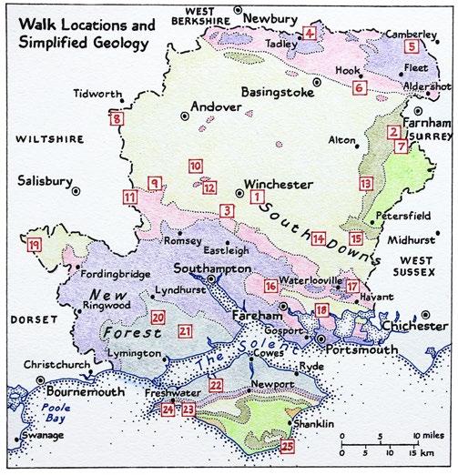
13 Simplified underlying geology of each site Chalk Upper Greensand and Gault London Clay Barton, Bracklesham and Bagshot Beds Fluvio-marine Series Chalk, Upper Greensand and Gault, and Lower Greensand Butterfly species recorded at site shley's picks Butterfly species Hampshire and Isle of Wight BUTTERFLY WLKS: sites and species check list Magdalen Hill Down Bentley Station Meadow and Lodge Inclosure Yew Hill Silchester Common and Pamber Forest Yateley Common Butter Wood bbotts Wood Inclosure Shipton Bellinger Broughton Down Stockbridge Down Common name Small Skipper Essex Skipper Silver-spotted Skipper Large Skipper Dingy Skipper Grizzled Skipper Clouded Yellow Brimstone Large White Small White Green-veined White Orange-tip Green Hairstreak Brown Hairstreak Purple Hairstreak White-letter Hairstreak Small Copper Small Blue Silver-studded Blue Brown rgus Common Blue Chalkhill Blue donis Blue Holly Blue Duke of Burgundy White dmiral Purple Emperor Red dmiral Painted Lady Small Tortoiseshell Peacock Comma Small Pearl-bordered Fritillary Pearl-bordered Fritillary Dark Green Fritillary Silver-washed Fritillary Marsh Fritillary Glanville Fritillary Speckled Wood Wall Brown Marbled White Grayling Gatekeeper Meadow Brown Small Heath Ringlet Cowley's Copse, Bentley Wood Pitt Down and West Wood Noar Hill Old Winchester Hill NNR Butser Hill NNR and Ramsdean Down Whiteley Pastures Havant Thicket Portsdown Hill Martin Down NNR Pignal and Ramnor Inclosures Hawkhill Inclosure and Beaulieu Heath Walter's Copse and Newtown Meadows IOW Brook, Compton and fton Downs IOW Tennyson Down IOW Bonchurch Down and Wheeler's Bay IOW Brown rgus
14
Hampshire Walks Sunday 29 April, meet at 10.30am Petersfield Heath (SU754227) Sunday 6 May, meet at 10.30am Oxenbourne Down (SU717189)
 Sunday 6 May, meet at 10.30am Oxenbourne Down (SU717189)") Hampshire Walks 2018 2018 will herald some new formats to the field trips programme. Some of the summer walks will start promptly at 09:30am as the Purple Emperor can be such a fickle creature, and I find
Hampshire Walks 2018 2018 will herald some new formats to the field trips programme. Some of the summer walks will start promptly at 09:30am as the Purple Emperor can be such a fickle creature, and I find
Silver-washed Fritillaries in the Straits Inclosure in July
 ALICE HOLT FOREST Hampshire from www.discoverbutterflies.com the website for the book Discover Butterflies in Britain D E Newland Silver-washed Fritillaries in the Straits Inclosure in July Alice Holt
from the website for the book Discover Butterflies in Britain D E Newland 2009
 BEACON HILL Hampshire from www.discoverbutterflies.com the website for the book Discover Butterflies in Britain D E Newland 2009 Beacon Hill lies at the western end of the South Downs, southeast of Winchester.
SHEEPLEAS. Visitor Guide and Self-guided Trails
 SHEEPLEAS Visitor Guide and Self-guided Trails Sheepleas The Sheepleas is an interesting mix of woodland, scrub and open grassland, situated on the chalk of the North Downs. This diversity of habitats
landcapes and romance Artists and poets have been inspired by the idyllic scenes of picturesque Kent villages sheltered by rolling, chalk hills.
 landcapes and romance Artists and poets have been inspired by the idyllic scenes of picturesque Kent villages sheltered by rolling, chalk hills. WALK 4 41 41 WALK 4 42 Pond Location: Distance: 5 miles
Butterflies of Lappeenranta - Finnland. Butterflies. of Lappeenranta. Finnland
 Butterflies of Lappeenranta Butterflies of Lappeenranta - Finnland Finnland 1 Profile: Lappeenranta Lappeenranta is a city of about 72 000 inhabitants in Southeast Finland, on the border between the European
Limestone terraces (in the distance) and woodland on hills in the Upper Wharfedale valley
 and woodland on hills in the Upper Wharfedale valley") GRASSINGTON North Yorkshire from www.discoverbutterflies.com the website for the book Discover Butterflies in Britain D E Newland 2009 Limestone terraces (in the distance) and woodland on hills in the
GRASSINGTON North Yorkshire from www.discoverbutterflies.com the website for the book Discover Butterflies in Britain D E Newland 2009 Limestone terraces (in the distance) and woodland on hills in the
BISHOPSTONE CIRCULAR WALK
 BISHOPSTONE CIRCULAR WALK 4½ miles (7¼ km) - allow 2 hours (see maps on final pages) Introduction This walk is within the North Wessex Downs Area of Outstanding Natural Beauty and starts from the small,
MILL HILL West Sussex
 MILL HILL West Sussex from www.discoverbutterflies.com the website for the book Discover Butterflies in Britain D E Newland Shoreham Bank, the south-western slope of Mill Hill, looking north in August
North Meadow National Nature Reserve
 Leaflet produced with the support of Cricklade Town Council. North Meadow National Nature Reserve For further information about North Meadow contact: The Senior Reserve Manager The Ebworth Centre, The
Singleton and the South Downs
 point your feet on a new path Singleton and the South Downs Distance: 13½ km=8½ miles easy walking with a few steeper sections Region: West Sussex Author: Hautboy Refreshments: Singleton, Hill Barn Date
Hindhead, Keffolds Copse and Gibbet Hill
 point your feet on a new path, Keffolds Copse and Gibbet Hill Distance: 6 km=4 miles Region: Surrey Author: Schwebefuss Refreshments: Punch Bowl Café moderate walking Date written: 14-apr-2015 Last update:
Bewl Water & the High Weald
 1 Bewl Water & the High Weald Stonegate station - Stonegate - Wallcrouch - Newbarn - Cousley Wood - Wood's Green - Wadhurst station Length: 9 ½ miles (15.3km) Underfoot: Large portions of this path are
Baggy Point, Croyde, North Devon
 Baggy Point, Croyde, North Devon A walk using the South West Coast Path that is likely to be suitable for people with impaired mobility or with a pushchair, wheelchair, or mobility scooter. The Coast Path
Section 6 WHALE CHINE TO FRESHWATER BAY
 Section 6 WHALE CHINE TO FRESHWATER BAY Introduction The route begins at Whale Chine and follows the Public ROW of the existing coastal footpath to the Lifeboat House at Freshwater Bay. The area is characterised
The Chilterns Conservation Board The Lodge Station Road Chinnor Oxon OX39 4HA
 The Chilterns Conservation Board The Lodge Station Road Chinnor Oxon OX39 4HA Tel: 01844 355500 Fax: 01844 355501 E Mail: office@chilternsaonb.org www.chilternsaonb.org PRESS RELEASE Chilterns Commons
START - UPHILL BEACH. (tidal!) The West Mendip Way is route-marked with these round blue signs
 The West Mendip Way is route-marked with these round blue signs") START - UPHILL BEACH Start Times: 10:30 11:15 12:00 Please allow sufficient time to check in with the marshals Start on the beach at the high water line (tidal!) The West Mendip Way is route-marked with
START - UPHILL BEACH Start Times: 10:30 11:15 12:00 Please allow sufficient time to check in with the marshals Start on the beach at the high water line (tidal!) The West Mendip Way is route-marked with
CRAZY HORSE TRAIL GUIDE
 CRAZY HORSE TRAIL GUIDE Abridged Version: July 2016 This is a short form of our interpretive trail guide for the Crazy Horse Trail. The full version of the guide has a more detailed description of the
Hadleigh Castle and Chalkwell Oaze
 1 Hadleigh Castle and Chalkwell Oaze Benfleet station Hadleigh Park Hadleigh Castle Leigh-on-Sea Chalkwell station A short stroll through the lush woods of Hadleigh Park high above the Thames-side marshes,
Coast Path Survey Stretch 09 Shalfleet Mill to Thorness Bay
 Coast Path Survey Stretch 09 Shalfleet Mill to Thorness Bay Overview Map of stretch Introduction This stretch of Island coast covers several salt marsh creeks backed by grazing land and woodland on the
Aston Rowant Discovery Trail
 The walk was developed by Aston Rowant Parish Council. The Trail is stile-free and fully way-marked. The circular route is 5.3m but with the extension to a pub and hotel 6.2m. Key Main Aston Rowant Discovery
Beautiful Walks from the Blue Ball Inn
 Walk No. 5 RIVER VALLEYS AND MOOR Countisbury, Watersmeet, Hillsford Bridge, Cheriton, Shilstone Hill, Rockford and Chiselcombe. 8.5 MILES APPROX. Walking time four and a half hours approx. OS 1;25,000
Penn Common and Bramshaw Wood
 Trail Activity Type Terrain Author Distance Ascent Location : HAMPTR0025 : Walk : Pub : Towpaths and Cycle Tracks : Anne-Marie Edwards : 5.3 miles / 8.5 kms : 381 feet / 116 metres : SU253173 / SP5 2BZ
Key Information. Self-Guided Walk Corfe Castle to Swanage
 Self-Guided Walk Corfe Castle to Swanage A classic walk from the pretty village of Corfe Castle. Enjoy extensive views whilst walking along the wide ridge to the popular seaside town of Swanage, returning
Newlands Corner Leaflet 08:Newlands Corner Leaflet 5/10/09 11:58 Page 1
 Newlands Corner Leaflet 08:Newlands Corner Leaflet 5/10/09 11:58 age 1 St Martha s is the start of the Downs Link, a 33-mile long distance trail linking the North Downs Way with the South Downs Way at
Notes and Views, Issue 7 - May to August 2016
 23 October 2016 Vince Massimo and Peter Eeles Citation: Massimo, V. and Eeles, P. (2016). Notes and Views, Issue 7 - May to August 2016 [Online]. Available from http://www.dispar.org/reference.php?id=118
Appendices A (Our ambition for nature (A3 plan) and further information)
 and further information)") Appendices A (Our ambition for nature (A3 plan) and further information) Penny Hill Farm Nature Conservation vision Key: Tenancy boundary Meadow restoration & Mowing/meadow F33 Mowing/meadow Progress towards
Appendices A (Our ambition for nature (A3 plan) and further information) Penny Hill Farm Nature Conservation vision Key: Tenancy boundary Meadow restoration & Mowing/meadow F33 Mowing/meadow Progress towards
Weatherman Walking Welshpool Approximate distance: 4 miles Start End
 Approximate distance: 4 miles For this walk we ve included OS grid references should you wish to use them. 4 3 2 1 Start End 5 6 N W E S Reproduced by permission of Ordnance Survey on behalf of HMSO. Crown
Gors Lydan barrows and medieval huts
 Walk Information: Maps: OS Explorer 214 Distance: 5.5 miles / 9 kilometres Duration: 4.5 to 5 hours Difficulty: Easy. Good paths and no steep gradients Start and finish: SO 11977545 Walk summary The walk
Designated Sites. Headlines
 Designated Sites Headlines Over 36% of the Sheffield district is covered by sites with European, national or local designation. These offer valuable habitats to wildlife, with some level of protection,
HARDMOORS 55 RACE ROUTE 2018 HELMSLEY - GUISBOROUGH
 HARDMOORS 55 RACE ROUTE 2018 HELMSLEY - GUISBOROUGH HELMSLEY - CHECKPOINT 1 (WHITE HORSE) 1. Leave RACE START, continue ahead on road (Baxtons Sprunt) At crossroads turn right down Canons Garth eventualy
BURGHCLERE PARISH RIGHTS OF WAY
 BURGHCLERE PARISH RIGHTS OF WAY Full descriptions compiled by Neill & Miggie Bruce All photos Miggie Bruce FP23 on Ridgemoor, looking south, with FP22 crossing by the bush FP1. From C183 Aldern Bridge
CWMGIEDD FROM ABERCRAVE
 Abercrave to Cwmgiedd Walk Page 1 Starting from The Abercrave Inn. Grid Ref: SN 824128 From the Abercrave Inn, an 11.3km (7 miles) walk to the foothills of the Cribarth Mountain, then through forest to
Aeron & Arth walks 4 walks for all the family to enjoy
 Aeron & Arth walks walks for all the family to enjoy Please take note that the maps illustrating these walks are intended as a rough guide only. You should use the most recent version of the relevant Ordnance
Beautiful Walks from the Blue Ball Inn
 Walk No. 2 WINSTONS WALK Countisbury, Wind Hill, Watersmeet, Ash Bridge and Winston s path. 5 Miles approx. Walking time- Two and a half hours approx. (Not including Breaks) OS 1:25,000 Sheet 64/74 Lynton
Morning Copse near Maidstone, Kent acres of Ancient Woodland with a pond, bluebells and mature oak. 26,500 (freehold)
") WOODS 4 SALE Phone: 01248 364 362 www.woods4sale.co.uk UK Woodland & Woods For Sale: Specialising in the Sales of Small Woodlands in England, Scotland and Wales for Recreation, Wildlife Conservation and
WOODS 4 SALE Phone: 01248 364 362 www.woods4sale.co.uk UK Woodland & Woods For Sale: Specialising in the Sales of Small Woodlands in England, Scotland and Wales for Recreation, Wildlife Conservation and
No. 78 Spring
 No. 78 Spring 2015 2 SATURDAY 25 th /SUNDAY 26 th APRIL SPRING AT ALNERS GORSE Saturday 8.00pm: moth trapping evening and camp with a backdrop of Nightingales. Camping facilities are available for anyone
Survey of Littleton Down
 Survey of Littleton Down 05 November 2014 The Team: John and Jenny Barnard 1) Introduction Littleton Down (Hill Number 2911, Section 42, OS 1:50000 Map 197, OS 1:25000 Map 121, Grid Ref. SU941150) is listed
TOWPATH MOWING GUIDELINES
 TOWPATH MOWING GUIDELINES 24 September 2007 CONTENTS Introduction Scope and Status of Guidelines Influences on the Guidelines Health and Safety Biodiversity INTRODUCTION Towpath management is a key issue
Ardingly Lake, Ouse Valley, Borde Hill
 point your feet on a new path Ardingly Lake, Ouse Valley, Borde Hill Distance: 14 km=9 miles or 12½ km=8 miles Region: West Sussex Author: Hautboy Refreshments: Borde Hill Map: Explorer 135 (Ashdown Forest)
Stephens State Park Trails
 TRAILS OF ALLAMUCHY MOUNTAIN & STEPHENS STATE PARKS Allamuchy Mountain and Stephens State Parks contain 28 marked trails providing access to diverse landscapes for walking, hiking, biking, bird-watching,
Ranmore Common and Polesden Lacey
 point your feet on a new path Ranmore Common and Polesden Lacey Distance: 9½ km=6 miles Region: Surrey Author: Fusszweig Refreshments: Polesden Lacey easy walking Date written: 20-dec-2016 Last update:
Butterflies and Moths of Slovakia
 Butterflies and Moths of Slovakia Slovak Karst butterfly heaven in the southeast Rosy Footman often found in our moth traps WHITE CARPATHIANS Westernmost projection of the Carpathian mountains covered
For full details please go to on the South East England page. Priory Wood, nr Basingstoke, Hants
 For full details please go to www.forests.co.uk on the South East England page Priory Wood, nr Basingstoke, Hants About 4 acres woodland - 39,000 freehold Location: East Moor, Old Basing, nr Basingstoke,
North Pennine Birdwalks. Walk 11: Dufton Pike
 North Pennine Birdwalks Walk 11: Dufton Pike The Birdwatchers Code of Conduct Birds are very vulnerable to disturbance, especially during the breeding season. It is all too easy to inadvertently harm a
Butterflies of London Atlas Project
 Butterflies of London Atlas Project 7 th April 2018 Welcome to this London Natural History Society project working with other organisations and individuals in London. Thank you for all the records to date.
Reigate Hill and Gatton Park
 point your feet on a new path Reigate Hill and Gatton Park Distance: 11½ km=7 miles easy-to-moderate walking or 2 walks of 6½ km=4 miles and 5½ km=3½ miles Region: Surrey Author: Schwebefuss Refreshments:
Wicklow Mountains Path Survey
 Wicklow Mountains Path Survey Glenmacnass Tonelagee Start to Finish: O 114 030 to O 085 016 Altitude (lowest highest): 370m 817m Weather: Sunny day, hot Access: Military Road, Glenmacnass Surveyed by:
Chevening and the North Downs
 1 Chevening and the North Downs Dunton Green station - Chipstead - Chevening - Knockholt - Hawley's Corner - Botley Hill - Oxted station Length: 12 ¼ miles (19.7 km) Underfoot: Portions of the walk are
Fetcham Downs and Bocketts Farm A magical teashop walk
 point your feet on a new path Fetcham Downs and Bocketts Farm A magical teashop walk Distance: 3 km=2 miles or 4 km=2½ miles Region: Surrey Author: Fusszweig Refreshments: Bocketts Farm easy walking Date
Lewes Downs (Mount Caburn) NNR. Welcome to the National Nature Reserve
 NNR. Welcome to the National Nature Reserve") Lewes Downs (Mount Caburn) NNR Welcome to the National Nature Reserve Welcome to Mount Caburn Lewes Downs (Mount Caburn) NNR is a chalk hill and valley with south-facing slopes, clothed in flower rich
Lewes Downs (Mount Caburn) NNR Welcome to the National Nature Reserve Welcome to Mount Caburn Lewes Downs (Mount Caburn) NNR is a chalk hill and valley with south-facing slopes, clothed in flower rich
Ivinghoe Beacon and the Grand Union
 1 Ivinghoe Beacon and the Grand Union Cheddington station - Horton Wharf - Ivinghoe - Ivinghoe Beacon - Bridgewater Monument - Aldbury - Tring station Length: 11 ¼ miles (18.3km) Underfoot: The first mile
Unimproved meadow with extensive riverside frontage and a bank of mixed hardwoods with good hard track access in the heart of rural South Wales.
 WOODS 4 SALE Phone: 01248 364 362 www.woods4sale.co.uk UK Woodland & Woods For Sale: Specialising in the Sales of Small Woodlands in England, Scotland and Wales for Recreation, Wildlife Conservation and
1. INTRODUCTION 2. CURRENT STATUS
 LOWLAND HEATHLAND AND LOWLAND DRY ACID GRASSLAND IN OXFORDSHIRE UK Biodiversity Group - Priority Species associated with heathland Nightjar Linnet Dingy mocha moth Grey scalloped bar moth, Other Associated
Leaden Boot Challenge 2016 ROUTE INSTRUCTIONS
 Leaden Boot Challenge 2016 ROUTE INSTRUCTIONS Section 1 Alstonefield to Ilam (CP2) From the village hall car park turn R then L and pass through the village keeping to the R to enter Church Street. Pass
Eastbourne. Alfriston 3¾ 6 3¾ 6. Birling Gap. Exceat
 3.8a Alfriston to Eastbourne (footpath) Map panel 6 (page 64) Distance 10½ miles (17 km) Terrain valley walk initially, first along riverbank path then hillside paths above, including stretch through forest;
Beamers Trail. Walk No.1. 6 miles. (easy with some moderate ascents and descents)
") Beamers Trail Walk No.1 6 miles (easy with some moderate ascents and descents) 1 BEAMERS TRAIL 6 miles (easy with som WALK The Warpers Trail forms part of the long distance Witton Weavers Way. This is
Beamers Trail Walk No.1 6 miles (easy with some moderate ascents and descents) 1 BEAMERS TRAIL 6 miles (easy with som WALK The Warpers Trail forms part of the long distance Witton Weavers Way. This is
A Circular Walk from Chapel Carn Brea
 A Circular Walk from Chapel Carn Brea 4.3 Miles A Walk Visiting Five Historic Ancient Sites This circular walk offers the possibility of several alternatives, depending on the walker s available time and
Yorkshire Dales classification of protected areas into IUCN Management Categories. Mark Fisher, November 2013 Wildland Research Institute
 Yorkshire Dales classification of protected areas into IUCN Management Categories Mark Fisher, November 2013 Wildland Research Institute Ingleborough National Nature Reserve Nesting of protected areas
From the car park go through the wooden gate and walk to a large information board and wooden totem pole ahead of you.
 Trail Dave Price, Geograph (CCL) Twin peaks What are these striking wooded hills here in an otherwise flat landscape? Time: 40-60 mins Distance: 1 ¼ miles Landscape: rural Standing at over 300 feet tall
Leaden Boot Challenge ROUTE INSTRUCTIONS
 Leaden Boot Challenge ROUTE INSTRUCTIONS Section 1 Alstonefield to Ilam From the village hall car park turn R then L and pass through the village keeping to the R to enter Church Street. Pass the Church
Walk 1. Cotswold Water Park. Gateway Centre to Cerney Wick, railway track to Lake 6, Gateway Centre.
 Cotswold Water ark Walk way A Swindon/ Cirencester Thomas and Severn Canal way to Cerney Wick, railway track to Lake, way. Spine Road East Hotel Time: hours (short walk km) Distance: km A level walk along
PRIORITY HABITAT SURVEY 2017 SWALEDALE. Summary. July 2018
 PRIORITY HABITAT SURVEY 2017 SWALEDALE Summary July 2018 Conservation & Monitoring Report No: Lead Author(s): Tony Serjeant & Sue Thurley Incorporating comments from: Gary Smith & Gordon Haycock (16/07/18)
This Passport: Revised October 20, 2017, EAM # Discovering the Trails of Webster, NY
 This Passport: Revised October 20, 2017, EAM #161923 Discovering the Trails of Webster, NY The Town of Webster invites you to explore and experience our diverse outdoor adventures! Here s your opportunity
Brinker Creek Ranch. Colorado - Routt County - Yampa
 Located at the base of the Flattops Range in the Steamboat/Vail corridor, Brinker Creek Ranch consists of 1,451 acres ideally suited for high country grazing and native grass hay production. Traditionally
TREK THE ROCKIES ABOUT THE CHALLENGE TREK THE ROCKIES FOR HIGHLAND HOSPICE CANADA TREK DEMANDING
 TREK THE ROCKIES CANADA TREK DEMANDING ABOUT THE CHALLENGE The Canadian Rockies are justifiably world-famous for their magnificent scenery: the combination of impressive, jagged mountains, bright turquoise
Self-Guided Walk Langdale Pikes. Start & Finish: NT car park (free to members) at Sticklebarn - on the right just beyond the New Dungeon Ghyll hotel.
 at Sticklebarn - on the right just beyond the New Dungeon Ghyll hotel.") Self-Guided Walk Langdale Pikes Key Information These mountains form a collection of spires and cliffs on the north side of Langdale. This walk visits four of the main tops Pavey Ark, Harrison Stickle,
Self-Guided Walk Langdale Pikes Key Information These mountains form a collection of spires and cliffs on the north side of Langdale. This walk visits four of the main tops Pavey Ark, Harrison Stickle,
RURAL LAND RESOURCES Case study area 1- the erosional features of the Dorset Coast.
 Case study area 1- the erosional features of the Dorset Coast. Scene setting;- This area lies on the far south coast of England, between the settlements of Lyme Regis and Bournemouth, in the county of
Sutton and Hollesley Heaths Walk Guide
 Outstanding Landscapes Sutton and Hollesley Heaths Walk Guide Explore the unique and rare landscape of the Sandlings heath and its diversity of wildlife and history. The Suffolk Coast & Heaths Area of
Mersey Valley Timberland Trail
 Route Pack Page 1 Route Summary A long distance linear walk on roads and country paths linking town and countryside to parks, woodlands and other open spaces. Grade Distance Accessibility Allow Start Map
The Mendip Way. Route Directions and Maps Uphill to Wells
 The Mendip Way Route Directions and Maps Uphill to Wells Website: www.mendiphillsaonb.org.uk Email: mendip@mendiphillsaonb.org.uk Facebook & Twitter: @MendipHillsAONB Phone: 01761462338 1 Uphill to Loxton
Ystwyth and Rheidol Bridleway Routes. Route 2:Llanilar Circular
 Ystwyth and Rheidol Bridleway Routes Route 2:Llanilar Circular Route overview and terrain: A long circle using connecting ridges with fine views to link the Rheidol and Ystwyth river valleys. The route
Derwent Valley Line Community Rail Partnership Annual Report Improving local stations and train services
 Derwent Valley Line Community Rail Partnership Annual Report 2015-2016 Improving local stations and train services Read about: Station Awards for Belper, Ambergate and Cromford More children's artwork
Delamere Loop. The. Useful Businesses Equestrian Escapes Tailor-made horse riding holidays in Cheshire. Tel:
 The Loop Accommodation Providers Akesmere Bed & Breakfast OS Grid Ref. SJ589/669 B&B for horse and rider. Chester Road, Little, Tarporley, Cheshire CW6 9ER Tel: 01829 760348 www.akesmerefarm.co.uk Useful
Orchards and oasts a taste of the Garden of England
 49 Orchards and oasts a taste of the Garden of England Open parkland, orchards, oasts and incredible panoramic views over the Weald to the South Downs make this a truly memorable walk. Linton Village 50
The rewards more than make up for the efforts of seeing the country this is a truly unforgettable trek.
 MADAGASCAR TREK ORANGE 2 ABOUT THE CHALLENGE This exciting trek takes us to remote Madagascar, where spectacular scenery and amazing wildlife awaits! From canyons and gorges to bush-covered plains and
Moorland View Princetown, Devon. 4.6 acres stand of high quality, mature conifer with good access for 28,000 (freehold)
") WOODS 4 SALE Phone: 01248 364 362 www.woods4sale.co.uk UK Woodland & Woods For Sale: Specialising in the Sales of Small Woodlands in England, Scotland and Wales for Recreation, Wildlife Conservation and
WOODS 4 SALE Phone: 01248 364 362 www.woods4sale.co.uk UK Woodland & Woods For Sale: Specialising in the Sales of Small Woodlands in England, Scotland and Wales for Recreation, Wildlife Conservation and
Hay Wood, Rowington and Baddesley Clinton - Warwickshire
 Hay Wood, Rowington and Baddesley Clinton - Warwickshire Starts at Lay-by alongside Hay Wood 2 hours 30 minutes 5.5miles 8.8km Leisurely ID: 0.683 Developed by: John Clift Checked by: Andy Page www.ramblersroutes.org
Early Butterflies. Trip report by Dr. Mario Langourov
 Early Butterflies Wednesday 25 th April - Saturday 5 th May 2012 Trip report by Dr. Mario Langourov Tour leader: Dr. Mario Langourov 1 Tour participants: Ms. Linda Jones Ms. Mery Palmer Ms. Margaret Hairby
Pontfadog. Walk A. Walk A
 Walk A A Bird s eye view of the village 2km. (1 1 /2 miles); height gain 45m. (150ft) about 45 minutes. Six minutes walk along the main road towards Glyn Ceiriog reach a signpost to Llwynmawr. Take the
Trail Phasing Plan. Note: Trails in the Clear Creek Canyon area (Segments will be finalized in the future to minimize wildlife impacts
 Note: Trails in the Clear Creek Canyon area (Segments 2 5 and a future JCOS connection) will be finalized in the future to minimize wildlife impacts Trail Phasing Plan P Parking 3 Easy Trail Intermediate
Councillor Briefing on Elvetham Chase
 Councillor Briefing on Elvetham Chase In partnership with the Calthorpe Estate, Wates Developments vision for Elvetham Chase is to provide an outstanding new community for Hart District that will become
CABERFEIDH, AULDEARN, NAIRN, SCOTTISH HIGHLANDS
 CABERFEIDH, AULDEARN, NAIRN, SCOTTISH HIGHLANDS CABERFEIDH AULDEARN, NAIRN An exceptional individually designed house with outstanding views of the Moray Firth, built in 1999 to the very highest standards.
Indonesia Orangutan Conservation (Sumatra)
") Indonesia Orangutan Conservation (Sumatra) Travel in a small group, staying in remote forest camps, as you track orangutans and other fascinating native species on this research project, vital to developing
Indonesia Orangutan Conservation (Sumatra) Travel in a small group, staying in remote forest camps, as you track orangutans and other fascinating native species on this research project, vital to developing
Kingley Vale and the Downland Churches
 point your feet on a new path Kingley Vale and the Downland Churches Distance: 21 km=13 miles or 10½ km=6½ miles Region: West Sussex Author: Hautboy Refreshments: Stoughton, Walderton moderate walking
My Derwent Hill Adventure
 My Derwent Hill Adventure Name Before your Derwent Hill adventure, try and find out the following information My group number is My dormitory is called The activities we plan to do include The activity
Countryside Trails Dunkeld
 R A N G E R S E RV I C E Countryside Trails Dunkeld WELCOME Welcome to this southern end of Atholl Estates. The countryside here is a wonderful blend of lochs, woodland and heather moor. There is a large
Woodland Walk If you enjoyed this walk there are two others available in the same area.
 The Woodland Walk 11-12 kilometres (7-8 miles) 4-5 hours Terrain: some easy hills Can be slippery when wet 5 stiles Unsuitable for a pushchair/wheelchair Uses OS map 197 Parking: Pulborough Station and
GRINDLEFORD GALLOP 2018
 GRINDLEFORD GALLOP 2018 Route Information The Grindleford Gallop follows a fixed 21 mile route through the lanes and paths of Derbyshire. All competitors must follow this route. An OS map of the area with
Walk 1: Highfield, Lob Wood and The River Wharfe
 Walk 1: Highfield, Lob Wood and The River Wharfe Start: The Hen Pen Garden, Main Street, Addingham LS29 0NS, SE 077 498. Alternative Start: Near Bolton Bridge SE 071 525 (see page 6). Full walk: 4.5 miles
Jake arrives at Euston station in London. It is a holiday weekend and it is his first time away from Manchester. Jake is eighteen years old and he
 Annette Keen Jake arrives at Euston station in London. It is a holiday weekend and it is his first time away from Manchester. Jake is eighteen years old and he lives with his family. Now he is in London.
Discover. Ashhurst Domain. Nature s Playground
 Discover Ashhurst Domain Nature s Playground Discover Step back into New Zealand, Aotearoa, of generations long gone. Discover lush natural surrounds echoing with rich birdsong in one of the Manawatu s
1/ Clatterjack 7a * SDS under right side of the roof. Out to lip, left to the arête and up before stepping back right to finish
 14 Crow Crag The potential of Crow Crag has gradually come to light though lines still remain unexplored. Despite the woodland location the excellent rock dries pretty quickly and there are some strong
Lowland Heathland in Nottinghamshire: Progress towards the LBAP
 Lowland Heathland in Nottinghamshire: Progress towards the LBAP Norma Saunders, Chief Executive Officer of The Sherwood Forest Trust Chair of Nottinghamshire Biodiversity Action Group The Seed of an idea
NEPAL LANGTANG TREK ABOUT THE CHALLENGE NEPAL TREK TOUGH
 NEPAL TREK TOUGH ABOUT THE CHALLENGE This magnificent trek, with the ultimate combination of spectacular scenery and fascinating culture, takes us to the magnificent Langtang region of the Himalayas, open
This path goes past an old tree nursery and sawmill. After 800m it crosses over a lane. Follow the bridleway fingerpost into the woods.
 FRENSHAM PONDS 11K CIRCULAR TRAIL 2½ HRS GU10 2DA This magnificent heathland trail starts in woodland and then brings you out onto the open heather of Frensham Common, with no roadwork! The route runs
Distance: 18 km=11 miles or 12½ km=7½ miles or 9 km=5½ miles
 point your feet on a new path The Devil s Dyke Distance: 18 km=11 miles or 12½ km=7½ miles or 9 km=5½ miles Region: West Sussex Author: Hautboy Refreshments: Devil s Dyke, Fulking, Poynings moderate ing
Self-Guided Walk Malham, Gordale and Malham Tarn
 Self-Guided Walk Malham, Gordale and Malham Tarn Combine all the major geological attractions of Malham in this walk and hopefully leave enough time to enjoy the cafes, pubs and shops of the village. Malham
Tranquil Wood Rhewl, near Ruthin, Denbighshire acres of medal-winning hardwoods for 26,500 (freehold)
") WOODS 4 SALE Phone: 01248 364 362 www.woods4sale.co.uk UK Woodland & Woods For Sale: Specialising in the Sales of Small Woodlands in England, Scotland and Wales for Recreation, Wildlife Conservation and
WOODS 4 SALE Phone: 01248 364 362 www.woods4sale.co.uk UK Woodland & Woods For Sale: Specialising in the Sales of Small Woodlands in England, Scotland and Wales for Recreation, Wildlife Conservation and
Sponsored by. statestreet.com
 /STATESTREETISLANDWALK #ISLANDWALKJSY Sponsored by statestreet.com Important Information If you forget everything else PLEASE remember the following.» Remember to check OUT of every checkpoint» If you