Hiking Rocks! Epic Trails in the Glacier Peak Wilderness. TENT! Details Inside! Seattle's Hiking DJ Geology on Trail
|
|
|
- Barrie Porter
- 5 years ago
- Views:
Transcription


1 Epic Trails in the Glacier Peak Wilderness A Publication of Washington Trails Association wta.org Win a New TENT! Details Inside! Hiking Rocks! Seattle's Hiking DJ Geology on Trail Wilderness Stewardship Protecting Your Trail Tech Shooting Macro Photos Jul+Aug 2014


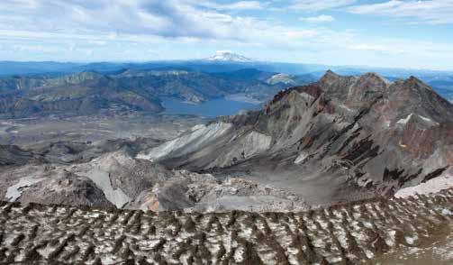
2 Jul+Aug 2014 NW Explorer Hiking Rocks A geologic guide to identifying the glacial and volcanic landscapes on Washington s trails.» p.20 Bob Rivers: Seattle s Hiking DJ How the popular radio host started in broadcasting, and why he chose the Seattle area to settle.» p.26 Welcome Back Wolverines Almost driven to extinction in Washington, these feisty creatures are on the rebound.» p NW Weekend» The Mountain Loop Explore the hiking, camping and area history between Darrington and Granite Falls.» p.38 WIN A NEW TENT! August is hiking month! See how you can win a new tent from NEMO or The North Face, then hit the trails!» p.18 & 33 News+Views Suiattle River Road Reopening this Fall» p.9 Lightning Bill Moves to Leecher Lookout» p.10 Enchanted Valley Chalet May Be Moved» p WTA at Work Trail Work» Road to Recovery on Boulder River Coming together where the work is needed.» p.12 Action for Trails» The Legacy of Trails How to identify different kinds of trails.» p.16 Trail Mix Gear Closet» Protect Your Tech on Trail Items for keeping electronics safe and useful.» p.42 Camera Bag» Marvelous Macro Capturing those up-close wildflower shots.» p.47 Bookshelf» Dirt Work by Christine Byl One woman s story of trail work in Montana.» p.49 Hike It! More Hiking Rocks! Eight trails showcasing Washington's diverse geology.» p.50 Epic Trail: Spider Meadow Buck Creek Loop A view-packed circuit in the Glacier Peak Wilderness.» p.58 Cover Photo» Miners Ridge, Glacier Peak Wilderness Backpacker Mark Cieniawski takes in the rugged expanse of the Glacier Peak Wilderness, including 8,760-foot Fortress Mountain. Photo by Buff Black. 2 Washington Trails Jul+Aug 2014 wta.org

3 Washington's Leading Hiking Resource and the Nation s Largest Volunteer Trail Maintenance Program Washington Trails Association is a volunteer-driven nonprofit membership organization working to preserve, enhance and promote hiking opportunities in Washington state. We engage and mobilize a community of hikers as advocates and stewards for our trails statewide. Through collaborative partnerships and grassroots advocacy, WTA focuses on state and federal issues, including trail funding, hiker safety and wilderness protection. WTA is committed to leaving a rich legacy of trails and wild lands for future generations to enjoy. WTA was founded by Louise B. Marshall ( ). Ira Spring ( ) was its primary supporter. Greg Ball ( ) founded the volunteer trail maintenance program. Their spirit continues today through contributions from thousands of WTA members and volunteers. President VP, Advocacy VP, Board Development VP, Fundraising Chair, Communications & Tech VP, Treasurer Secretary Board of Directors LISA BLACK PERRY BURKHART AMY CSINK DAMIEN MURPHY TITTI RINGSTROM ADAM RYND WENDY WHEELER JACOBS STEPHEN TAN CRAIG MCKIBBEN STEVE PAYNE ROB SHURTLEFF ANDREA BAINES CAROLE BIANQUIS BRUCE BURGER JEFF CHAPMAN JOE GREGG BILL POPE KATE ROGERS MASON WHITE Washington Trails Association 705 Second Avenue, Suite 300, Seattle, WA (206) wta.org Northwest Office Southwest Office General Information Membership Information Volunteer Information Editorial Submissions Advertising Directors At Large (360) (360) wta@wta.org membership@wta.org trail_teams@wta.org editor@wta.org advertising@wta.org Executive Director Development Director Development Manager Finance & Operations Director Information Services Manager Membership Manager Communications Director Advocacy Director Digital Content Manager Washington Trails Editor Outreach Manager Program Director Field Programs Manager Field Programs Manager NW Regional Manager SW Regional Manager Youth Programs Manager WTA Senior Staff KAREN DAUBERT KATE NEVILLE LISA UNSOELD-CHANG MARJORIE KITTLE CHARLIE KAHLE KARA CHIN SUSAN ELDERKIN ANDREA IMLER LOREN DRUMMOND ELI BOSCHETTO KINDRA RAMOS REBECCA LAVIGNE ALAN CARTER MORTIMER TIM VAN BEEK ARLEN BOGAARDS RYAN OJERIO KRISTA DOOLEY Washington Trails Volunteers Copy Editors Contributors Illustrators Proofreader Regional Correspondents JIM CAVIN, REBECCA KETTWIG TAMI ASARS, PAULA MACKAY PAUL RAYMAKER, CRAIG ROMANO REBECCA JENSEN, WHITNEY MAASS MITZI SUGAR NATE & JER BARNES, KELSIE DONLEYCOTT DAWN ERICKSON, DAVID HAGEN LINDSAY LEFFELMAN, BRITTANY MANWILL MIKE MORRISON, KRISTEN SAPOWICZ AARON THEISEN, HOLLY WEILER Connect With WTA: /washingtonhikers /wta _ hikers /wtahikers /WTAhiker /washingtontrails# Washington Trails Vol *, Issue 4 Owner & Publisher WASHINGTON TRAILS ASSOCIATION Washington Trails (ISSN ) is published bimonthly by the Washington Trails Association, 705 2nd Avenue, Suite 300, Seattle, WA Annual membership dues, which include a subscription to Washington Trails magazine, are $40. Single copy price is $4.50. Periodicals postage paid at Seattle, WA, and at additional mailing locations. POSTMASTER: Send address changes to Washington Trails Association, 705 2nd Ave., Suite 300, Seattle, WA *Due to a years-old error in the sequencing of Washington Trails, all 2014 issues will be labeled as Volume 49.1 in order to get back on the correct track with Volume 50 in Washington Trails Jul+Aug 2014 wta.org 3


4 FRONT DESK Karen Daubert A Summer to Celebrate Summer. It s my favorite time to explore new trails and celebrate Washington s great outdoors. The snow has melted in our mountain meadows, the sun is shining and the days are long. It is also the ideal time to welcome new members to Washington Trails Association. I hear it all the time: I have used your website for years and now I am a member! This is joy to my ears because it means more support for our challenged trails. This summer, Washington Trails Association is celebrating trails in an unprecedented way. It all starts on July 1 with the opening of registration for WTA s 11th annual Hike-a-Thon. Last year, Hike-a-Thoners helped raise more than $90,000 for trail projects and maintenance across the state. This year, with your help, we re aiming even higher to help offset the continuing budget shortfalls faced by our state and national land managers and to keep trails open and accessible. And all Hike-a-Thon participants will be eligible to win great prizes in a variety of categories. After you register, you can start planning how to Make Your Miles Count. Look for WTA mixer events near you to meet fellow Hike-a-Thoners and plan a hike together; join a team and choose one of the many mileage or fundraising challenges; or, get ideas on how to challenge yourself and set your own personal hiking goals. Then on August 1, it s ready, set, hike! But that s just for starters. Last year Gov. Jay Inslee officially proclaimed the first Washington Trails Day, and this year it's carrying forward. On August 2 we ll be celebrating the second annual Washington Trails Day, a day where all Washingtonians are encouraged to get outdoors and have fun exploring Washington s diverse and abundant hiking trails. Hike with your family, a friend or a coworker. Take someone hiking who s never hiked before, or try a new trail. This year, WTA is putting an extra celebratory spin on Washington Trails Day. There will be WTA staff hiking on trails across the state. If you re spotted with WTA anywhere on yourself a WTA shirt or hat, a Hike-a-Thon shirt, or the downloadable WTA badge (visit the website below) you just might get a trail treat or WTA prize. And if you snap a photo of yourself high-fiving someone on trail your kids, your friends, your dog or a complete stranger and post it on Instagram, you will be entered into a drawing to win a new tent, courtesy of The North Face! I will be on a trail in the Teanaway on Washington Trails Day. Find me and I may have a reward for you! Then I ll be hiking throughout Hike-a-Thon with the goal of hiking more than 100 miles, raising more than $1,000 dollars and ascending more than 10,000 feet of elevation! So join me this summer in celebrating and supporting Washington s trails. Happy Hiking, > Register for Hike-a-Thon, or sponsor a hiker, at wta.org/hikeathon > Learn about Washington Trails Day festivities at wta.org/watrailsday TOP: WTA volunteers complete a project to increase hiker safety and prevent erosion on the Horseshoe Bend Trail near Mount Baker. This was one of ten WTA work parties statewide celebrating National Trails Day on June 7. MIDDLE: Thanks to day-trip volunteers and WTA youth crews, a new 0.25-mile trail linking the moorage area to Beacon Rock State Park s namesake monolith is now open. BOTTOM: WTA executive director Karen Daubert (center-right) and staff welcomed more than 70 Fireside Members to the annual Fireside Celebration, held this year at Bellevue Brewing Co. Learn more about becoming a WTA Fireside Member at wta.org/fireside. 4 Washington Trails Jul+Aug 2014 wta.org

5 Editor s Choice Tasty New Trail Eats SIGNPOST Eli Boschetto editor@wta.org It s that time of year again: time to start meal planning for my summer hiking trips. This year is going to be an especially challenging one as I not only have to consider the local long weekend trips, but also two 2-week stretches on the Pacific Crest Trail. Thankfully, I ll be able to mail myself several resupply packages so I m not carrying all that food at once. When it comes to long-distance trail menu planning, I like to take the easy way out: quick meals and freeze-dried options. After putting in long days and long miles, I like to add water, sit and eat. Many of my favorite backpacking meal brands including Packit Gourmet and Mountain House have a very tasty selection of lightweight and quick-cooking meals. But spending a month on trail means needing to change up the menu beyond my favorite handful of meal choices. I recently had the opportunity to sample some new backpacking menu selections from Oregon-based Mountain House, and new company Good To-Go, out of Kittery, Maine. Mountain House s big new item is Biscuits and Gravy. Just add hot water, let steep for ten minutes and it's just like Saturday breakfast at my favorite diner down the street. With perfectly-textured gooey crispy biscuit bites smothered in rich sausage gravy. I will be packing lots of Biscuits and Gravy on my summer adventures this year. Also new from Mountain House is a tasty Fire Roasted Vegetable Blend. It works well as a side dish, wrapped in a tortilla or added to pasta. Good To-Go currently offers three dehydrated menu selections: Smoked Three Bean Chili, Herbed Mushroom Risotto and Thai Curry. The Three Bean Chili is really good, with a thick, tomatoey, just-right spicy sauce, while the Mushroom Risotto is rich and creamy. I don't do curry, but I m told the Thai Curry is plenty tasty. And Good To-Go meals are vegetarian and gluten-free. Try expanding your own backcountry menu with one of these new meal options. Get more info and purchase these items at mountainhouse.com and goodto-go.com. Seeking Inspiration All we have to decide is what to do with the time that is given to us. Gandalf the Grey As hikers, and general lovers of the outdoors, we seek inspiration in the photos and tales of fellow hikers. These images and stories motivate us to explore new places, experience new sights and even learn new lessons. Oftentimes, once we've experienced these new things, we're motivated to want to share them with others. This keeps the cycle of seeking, finding and sharing inspiration going. in spi ra tion noun (Merriam-Webster) something that makes someone want to do something or that gives someone an idea about what to do or create a person, place, experience, etc., that makes someone want to do or create something a good idea Here at Washington Trails, we're working on a very special issue to wrap up the year. The theme (as you probably guessed) is seeking and finding inspiration in the outdoors a fitting way to wrap up a year-long celebration of wilderness. To do this, we will be presenting your own stories about what inspires you to seek adventure and rejuvenation, and how you may encourage others to do the same. Seeking and sharing inspiration What inspires you? Did a magazine or guidebook photograph inspire you to lace up your boots and hike a new trail to someplace you've never been before? Did the achievement of another inspire you to challenge yourself to a similar goal, like summiting a high peak or taking your first overnight backpack? How do you inspire others? Do you post Trip Reports detailing the hikes you do, with all the great reasons for getting out and exploring that area? Did you participate in trail work party and felt such a sense of pride and accomplishment that you have encouraged others to do the same? Share your stories and photos at inspiration@wta.org. Inspiration comes in all shapes and sizes. Send us your funny stories, your touching stories, your embarrassing stories; your stories of fantastic experiences and lessons learned on trail. We will present a selection of your stories and photos in the final issue of the year as a way of celebrating the people and places that motivate us to continue seeking our own inspiration on Washington s trails. Washington Trails Jul+Aug 2014 wta.org 5


6 COMMUNITY Trail Talk HIKING TIPS FROM WTA: Hiking Rock or Hiking Rocks? In the spirit of this issue s theme, we asked WTA staff, board and team members which they preferred on trail: rock or rocks. "I like rocking out to pika squeaks." Rebecca Lavigne, Program Director "I rock out on solo hikes by starting off with some of my favorite upbeat tunes. Once I've gotten in the groove I take out my earbuds and am quickly captivated by all the nature sounds around me.." Kristen Sapowicz, Regional Correspondent "Trail rocks! I employ my Go-Go-Gadget granite magnet to find the best climbing and scrambling routes around." Andrew Pringle, OLT Coordinator "I let the birds provide the soundtrack. Rocks are way cooler than rock." Holly Weiler, Eastern Regional Coordinator "When I go trail running, I like to listen to music or podcasts. When I'm hiking, I like to observe my surroundings without technology." Andrea Martin, Youth Programs Coordinator "I don't rock to an auditory beat, but rather rock to the upbeat tempo of my own soaring spirit while out on a high mountain trek." Julie Cassata, Volunteer Coordinator "While on the trail, I roll with no rock, blues or any of that jazz. My ipod contains epic poetry Gilgamesh, Beowulf, The Odyssey and The Aeneid are in heavy rotation." Mason White, Board Member Facebook Question: If you were directing a film about Washington's trails, what songs would you put in the soundtrack? From Jimi Hendrix to Jose González, our Facebook community created one beautiful insane eclectic soundtrack for Washington s trails. We turned a small selection of the ideas into a playlist with mostly Washington roots. u 1. Roll On Columbia - Woody Guthrie u 2. Society - Eddie Vedder u 3. The Quest - Jeff Bridges u 4. Two Little Feet - Greg Brown u 5. The Cascades - Fleet Foxes u 6. Wildflowers - Tom Petty u 7. Learn To Fly - Foo Fighters u 8. Another Beautiful Day in the Pacific Northwest - Big Business u 9. Washington My Home! - Sicko u 10. Turn Off This Song and Go Outside - The Lonely Forest Song suggestions by Linda Jo Hunter, Frank Rigney, Anna Roth, Kara Silverston Harris, Dough Philips and Melanie Cooper, Linda Roe, Kale Tegman, Josh Rubin and Michele McNulty Finnegan. To mix and match your own playlist from 125+ suggestions, visit wta.org/soundtrack. WTA VOLUNTEER PROFILES: Crew Leaders Jon Nishimura volunteered for his first WTA work party on the West Fork Foss Trail in June Like many first timers, he was quiet and a little apprehensive. But just two short years later, he has completed his 250th work party! His favorite work locations include Larrabee State Park and Tiger Mountain. Jon s love of trails and his fellow volunteers is evident on each and every work party. Look in his extremely heavy backpack to find extra clothes for a cold volunteer and popcorn to pop and share at lunch. Jon volunteered to become an assistant crew leader last year and shows no sign of slowing down. Every time I go out, it is a privilege and blessing to work with the amazing volunteers, he says. The camaraderie, teamwork and conversations make each work party special. Volunteering is a way of life for John Clark, who has been a trail maintenance volunteer with WTA since John also gives back as a volunteer Community Emergency Response Team leader in Snohomish County, an appointment that sent him to the Oso Mudslide to do radio operation and artifact recovery. John is committed to making a difference where he s needed, whether doing emergency response or supporting WTA s growing youth program. His favorite youth experience so far has been working with fourth and fifth grade students from Green Gables Elementary, where he taught a group how to safely roll a huge log as a team. By volunteering with these future steward says John, I hope to get them fired up and excited about working outdoors. 6 Washington Trails Jul+Aug 2014 wta.org

7 COMMUNITY In Photos WTA Photo Contributor Wins National Award hotographer Andy Porter, a frequent contributor to Washington Trails, won an Honorable Mention in this year's Wilderness Forever photo contest, sponsored by Nature's Best Photography magazine. His photo of Sahale Arm Camp will be displayed with other winners at an exhibit at the Smithsonian Museum to honor the 50th anniversary of the Wilderness Act. Congratulations, Andy! My connection with wilderness began when I was 16. I spent a month in the Sawtooth Wilderness in Idaho, learning how to backpack, climb and survive. The trip changed my life and encouraged me to continue. Treks along the Pacific Crest Trail and the Andes followed. Then my life changed again and I was off on a different path. For almost 20 years I followed the light, only to wind up in the darkness. And then I felt the wilderness call to me again, beckoning me back into her arms. I had packed my old life in boxes, and uncovering them produced an old hiking guide. I scoured it and found the most exciting-sounding trip in there, recruited a few friends to accompany me, and off we went. I had forgotten what mileage and elevation gain portended, and as we began our trip up to Sahale Camp, it slowly came back to me what sweat and struggle were all about. We finally made it to the camp well after dark and collapsed in our tent. This image was captured the next morning. My life was changed anew; I had found a new purpose. Wilderness had rescued me again. Washington Trails Jul+Aug 2014 wta.org 7


8 HIKING NEWS Across Washington Blue Ribbon Task Force Needs Your Help Trails & Ales Seattle & Chimacum MEET Hikers. TALK Trails. DRINK Beer (and cider). Join WTA at } Fremont Brewing on July 23 } Finnriver Cidery on August 5 OLYMPIA In February, Gov. Jay Inslee formed a Blue Ribbon Task Force on outdoor recreation with the goal of boosting the state s recreation economy. Now that same task force needs to hear from hikers, trail runners and other trail users as they chart the future of recreation in Washington. Share Your Ideas in Person or Online As part of its efforts to engage hikers and other recreationists, the task force is hosting public forums across the state to hear what matters most to people. Upcoming meetings are scheduled for July 8 in Wenatchee and August 19 in Port Angeles. More details can be found at the task force s website. Gov. Jay Inslee with Smokey Bear at Darrington Days, celebrating local art, music and culture, and the preservation of Green Mountain Lookout. RSVP at wta.org/events If you can t make it to a meeting, take part in a virtual town hall at the Engage Outdoor Washington website. Sign up to participate or connect with your Facebook account. Then just answer the rotating questions. New questions are added periodically. Past questions include }} Should the state leave outdoor recreation marketing and tourism to the private sector, or play a specific role? }} What are your ideas for getting outdoor companies interested in Washington state? }} What groups and individuals do you think participate less frequently in outdoor recreation in Washington? Why? Why Outdoor Recreation Matters in Washington Each year, more than two-thirds of Washingtonians recreate outdoors. Add to that the thousands of out-of-state visitors who come each year to enjoy our incredible scenery and what you get is an outdoor recreation economy that directly supports 227,000 Washington jobs and generates $22.5 billion statewide in annual spending. The governor s task force aims to safeguard and grow that economic activity through a healthy, wellmanaged system of trails and other recreation facilities on public lands. Photo by Aida Lee Gordon Thank You for Giving BIG! The Seattle Foundation's fourth annual Give BIG event on May 6 raised more than $75,000 for WTA's work to protect and maintain trails. Of 1,471 participating nonprofits, WTA placed 6th by number of donations and 20th by amount received. In all, the Give BIG event raised $12.8 million for nonprofits working to make our region a better place to live, work and play. Thank you to all who contributed! 8 Washington Trails Jul+Aug 2014 wta.org
 located northwest of Darrington is getting ready to reopen in November.")
9 Suiattle River Road to Reopen in Late Fall MT. BAKER SNOQUALMIE NATIONAL FOREST After 10 years of closures and scores of frustrated motorists, the Suiattle River Rd (FR 26) located northwest of Darrington is getting ready to reopen in November. That s great news for hikers who want to take advantage of the primary gateway to the Glacier Peak Wilderness without leaving their cars at milepost (MP) 11.6 of the 23-mile road, where for several years a gate has cordoned off damage from the floods of 2003 and Extensive summer construction will tackle four major areas of the Suiattle that must be fixed before the forested corridor can be opened to motorists. Repairs include rerouting the road away from the eroded riverbank at multiple places, replacing old culverts, building a new bridge over Downey Creek and reestablishing the Huckleberry Mountain trailhead parking lot. Impacts to Summer Hikers Due to construction efforts and safety concerns, access to the Suiattle River Rd will be impacted at various times during the summer. For more information, check out the project s website at wfl.fhwa.dot.gov/ projects/wa/suiattle. The Department of Transportation is also offering a weekly newsletter of construction updates; a subscription can be requested by ing wfl.suiattleriverroad@dot.gov. Key Mileage Points Along the Road The Suiattle will remain closed to motor vehicles at MP 11.6 until the end of construction. Nonmotorized traffic (hikers, bicyclists, horseback riders) is currently allowed beyond the gate from MP 11.6 to MP At MP 20.8 crews have begun to clear the road. Due to safety concerns, the road beyond MP 20.8 is closed to all public travel on weekdays from 7 am to 5 pm. In June, the temporary footbridge at MP 20.9 (Downey Creek Bridge) was removed to prepare the area for construction of a new motor vehicle bridge. All public travel past the junction with Green Mountain Rd (FR 2680) is discouraged until the new bridge is installed. Rediscovering the Suiattle Hikers have a lot to look forward to once the bridge and the road is open. Seven popular trails will once again be easily accessible, including the Pacific Crest, Suiattle River, Green Mountain, Downey Creek, Huckleberry Mountain, Sulphur Mountain and Sulphur Creek trails. Hikers will also be able to stay at two campgrounds, rent the Suiattle Guard Station cabin and access dispersed camping along the Suiattle River Rd. The schedule to reopen the campgrounds and guard station is still being determined. While hikers will be eager to hit the trails come November, a word of caution: Many of the trails along the Suiattle River Rd have not been maintained since the road closed in Hikers will likely encounter brushy trails and downed trees on their adventures until trail maintenance crews including WTA volunteers can get in and start clearing the trails, which likely won t begin in earnest until Stay up to date on trail and road conditions by following WTA's Signpost blog at wta.org/signpost. Washington Trails Jul+Aug 2014 wta.org 9

10 HIKING NEWS Across Washington Lightning Bill Moves From Goat Peak to Leecher Lookout OKANOGAN WENATCHEE NATIONAL FOREST Those hoping to catch a glimpse of U.S. Forest Service lookout legend Lightning Bill Austin will find him in a new spot this year. After a 19-year tenure at Goat Peak in Mazama, Austin has been reassigned to the Leecher Mountain Lookout southeast of Twisp. The move comes amid a shrinking Forest Service budget and shifting firefighting resources. Austin, who lives in Bridgeport when he s not watching for forest fires, is the only full-time seasonal fire lookout remaining in the Methow Valley Ranger District. But that s not his only claim to fame. During his time at the Goat Peak Lookout, Austin earned a cult following for personally greeting many of the lookout s 2,000 visitors each summer and inviting hikers inside during lightning storms. He especially loved giving tours to children. Over time, he arguably became as much of a tourist attraction as the lookout itself and now stays in touch with his so-called fan club via a popular Facebook page. As of mid-june, Austin has settled into the Leecher Mountain Lookout and is ready for visitors. Connect with him and learn more about his life in the lookout at facebook.com/lightningbill. Olympic National Forest: Which Roads Do You Use? OLYMPIC NATIONAL FOREST With more than 2,000 miles of roads and a dwindling maintenance budget, Olympic National Forest (ONF) has embarked on an effort to identify the minimum road system needed for the forest and forestry officials want your help. ONF is holding multiple open houses around the Olympic Peninsula this summer to ask hikers and other forest visitors which areas and roads they use most, as well as what they do there. The answers will help determine which roads in the forest will stay open and which will get closed or decommissioned. If you can t make it to a meeting, you can still chime in online. Visit ONF s website and participate in their electronic questionnaire, or check out their interactive mapping tool that allows you to highlight roads and special places that are important to you. WTA will be following this process and keeping you up to date as it develops. Get more info at wta.org/onfroads. Attend an Olympic National Forest open house in your community and share what s important to you. r July 17 Port Townsend Port Townsend Community Center r July 30 Quinault Quinault Ranger Station r August 19 Shelton Shelton Civic Center r August 21 Aberdeen Rotary Log Pavilion r August 27 Olympia ONF Supervisor s Office 10 Washington Trails Jul+Aug 2014 wta.org

11 What New Study Reveals About Youth and the Outdoors The Outdoor Foundation released its 2014 Outdoor Recreation Participation Topline Report in May. The report is the only detailed study of its kind tracking American participation trends in outdoor recreation and focuses on youth, young adults and the future of the outdoors. The data came from 19,240 online interviews carried out with a nationwide sample and uncovered some encouraging trends. Major takeaways include these positives: A record million Americans participated in at least one outdoor activity in 2013 that s 49.2% of the population. Collectively, people went on 12.1 billion outdoor outings. Outdoor participation among youth and young adults showed promise, with an annual average of 99 outdoor outings per person. In comparison, that is more than the 77 annual outings participants ages 25 and up took in Young participants were slightly more diverse in 2013 than they were in This was in part due to increased Hispanic participation, which grew from 8% in 2012 to 10% in Young females are now participating in outdoor activities at the same rate as young males. That wasn t the case from 2008 to The most popular activities among young people, in terms of overall participation, continued to be running, biking, fishing, camping and hiking. Adults reported similar favorite pursuits. PARK UPDATEs: Enchanted Valley Chalet Moving? OLYMPIC NATIONAL PARK With the Enchanted Valley Chalet still teetering on the bank of the East Fork Quinault River, park officials have announced a plan to temporarily move the building approximately 50 to 100 feet away from the river. The move is an interim solution to save the chalet, which is listed on the National Register of Historic Places, and to protect the water quality of the East Fork Quinault River an important habitat for a variety of salmon and the endangered bull trout. The park accepted public comments on its proposal in June. WTA supports the park s efforts to protect the river by temporarily moving the chalet. In its letter to Olympic National Park, WTA advocated that costs incurred by relocating the chalet should not deplete the budgets of other park functions, such as trail maintenance and recreation. WTA also asked that impacts on hiker access to the Enchanted Valley be kept to a minimum during the busy summer hiking season. A decision on the temporary move is expected in the coming weeks. To learn more about the chalet, visit wta.org/chalet. Trail running saw a significant increase in popularity, up 13% from Participation in climbing increased 6% and backpacking increased 4% during the same period. While the individual takeaways of the study are encouraging, the overall trend is even more positive: there is a growing demand for on-trail activities and an increasingly active young generation. The Next Step: Channeling that outdoor enthusiasm into a passion for stewardship. Photo by Ben Jensen Join the Fireside Circle Fireside Circle donors are committed to supporting WTA's education, advocacy and trail maintenance programs. Your gift of $500 or more helps ensure a lifetime of outdoor adventure for you and for generations to come. Fireside Circle benefits include: One-year WTA membership Hiking opportunities with WTA board and staff Exclusive summer newsletter Early notice of WTA Volunteer Vacations Renew or join today at wta.org/fireside Washington Trails Jul+Aug 2014 wta.org 11

12 WTA AT WORK Trail Maintenance Originally featured as Return to Oso and a Step Towards Normal on the Zero to Summit blog. Story and photos by WTA volunteer Paul Kriloff. As efforts to clean up continued in Oso a month after the deadly landslide, I found myself part of a different kind of recovery effort just a couple of miles away. A group of ten volunteers from Washington Trails Association and three U.S. Forest Service representatives participated in a week of maintenance on the Boulder River Trail, WTA s first work there since Our crew leader, Lisa, explained that there had been debate about whether it was appropriate to go ahead with the trail maintenance scheduled long before the slide but the Darrington Ranger District asked WTA to continue as planned. District staff wanted to be ready for the return of hikers to the area. The trail is also important to the local community. Boulder River is to Darrington what Mount Si is to Seattle: a trail that gives people immediate access to wilderness in their own backyard. Starting just a few minutes from town, the trail enters old-growth forest in a little over a mile. The area is one of the few lowland valleys in western Washington and the only stretch of forest on Mt. Baker-Snoqualmie National Forest never to have been logged. Motivated by More Than Trails Oso and Darrington are gateways to one of my favorite parts of the Cascades: the Mountain Loop. By mid-spring last year, I had already been in this neck of the woods several times. But this was my first time in the area since the slide occurred. I came back now out of a desire to help out. I was not the only one with that motivation. In talking with other volunteers some of whom had made an even longer trek than my two-and-a-half hour drive from Seattle I found that helping the community around Oso was a big part of why they had chosen this work party and this trail. Another volunteer, Laura, put it simply: It s nice to be able to do something to help. Regular Work, Far From Routine Trails provide a microcosmic example of the forces that caused such massive devastation in Oso. In our desire to be closer to the magnificence of an area like the Stillaguamish Valley, humans forge inroads into wilderness. As soon as we begin these projects, natural forces start dismantling what we create. There is a constant struggle to maintain ground. Rains wash away sections of trail. Wind blows down trees that obscure long stretches of tread. Even humans who help build these ways into wilderness can later jeopardize the quality of them, since hikers tendency to stay downhill causes trails to migrate slowly downward and eventually slough away completely. It takes constant maintenance to combat those forces. It also takes a cheerful army of volunteers. The Darrington Ranger District alone has 350 miles of trail with just five 12 Washington Trails Jul+Aug 2014 wta.org


13 employees responsible for managing and maintaining them: one supervisor, two full-time field staff and two seasonal employees. While regular maintenance happens all the time, the work is far from routine and on this occasion, that was even truer than usual. Countless buckets of earth were moved. Massive trees were sawed in two. It was difficult and potentially dangerous work. This time, though, it was carried out with the knowledge that a couple of miles away, much larger crews were engaged in a titanic effort to clear a highway. The crews in Oso were undertaking far more dangerous jobs as well: finding the final few missing and cleaning up splintered trees, homes and other debris. Perhaps because of this, the work at Boulder River was even more cooperative and productive than usual. Work parties are always lighthearted and collaborative WTA lives out its creed of Be safe. Have fun. Get work done. In a few short hours, a trail that had been all but impassable in places was cleared and restored through its first 2 miles. It was an impressive amount of progress for a single day. A Step Closer to Normal Things are still far from normal in Oso and Darrington. Yards, signs and local landmarks are adorned with yellow ribbons of hope and support. A road sign advertises the tollfree number for FEMA. The local ranger station doubles as a center for federal disaster relief. While no one will forget the disaster that struck here, getting back to normal doing things like going on a hike will be an important part of the recovery process. While it s not as important as rebuilding homes or helping people displaced by the slide to reestablish themselves, efforts like the one on the Boulder River Trail are a step down that path. I was grateful for the chance to help. You can help maintain trails in the Darrington area at one of these summer work parties. u Mount Dickerman July 8 11 u Pinnacle Lake July u Independence Lake Jul & u Pinnacle Lake Aug Visit wta.org/volunteer for more information. Washington Trails Jul+Aug 2014 wta.org 13

14 WTA AT WORK Youth Program By Andrew Pringle A Priceless Experience It doesn t sound particularly fun to lug rocks up a muddy trail while the trees drip on you, says teenager Anika, a peer leader with the Service Board. It sounds kind of awful, actually. It was slippery, muddy, slightly terrifying [but] absolutely satisfying. At the end of it, I was proud of myself and my group for making a tangible difference in the trail we worked on. Despite the rainy work day, Anika s pride was due to a lot of hard work and a mini-grant from WTA s new Outdoor Leadership Training (OLT) program. The funding, meant to support youth groups that need financial assistance for outdoor experiences, has already made a wide range of trips possible, from trail maintenance to hiking to camping. In the process, the program has helped provide outdoor experiences for youth who often have few opportunities to get outdoors all while inspiring the next generation of hikers and conservationists. Tents & Packs Sleeping Bags Rain Gear Hiking Boots Kitchen Gear Sign up for a camping workshop to access WTA s free Gear Lending Library. Building trails is a unique experience that introduces [teens] to interurban trails and suburban green space, says the Service Board mentor Christabel Escarez, as well as their part in creating and maintaining these natural areas. MINI-GRANTS MAKE A DIFFERENCE An educator from Renton Academy, an alternative K-12 school, used a mini-grant to support a dayhike and overnight camping trip. Students completed a Rites of Passage program that in part involved reflecting on becoming an adult. The venue a campsite far away from school proved to be integral for group bonding and personal growth. A youth programs coordinator from the Coalition for Refugees From Burma (CRB) used a mini-grant to help support a trail maintenance work party during a three-day conservation camp. As part of the camp, students built new trails. For most students, it was their first time on trail. I would estimate about 85% of the students had never been hiking in the United States and about 90% had never done trail work before, said CRB Youth Programs Coordinator Siobhan Whalen. Do you know a school or organization that needs support to get youth groups out hiking and camping? Visit wta.org/olt for more information. Visit wta.org/olt We extend our thanks to WTA s Corporate Partners Rainier - $25,000+ Olympic - $10,000-$24,999 Cascade - $2,500-$9,999 Alpine - $1,000-$2,499 Hilleberg Seven Hills Running Shop Cascade Crest 100-mile Endurance Run To find out how your company can support WTA s work for trails, please call us at (206) or lisac@wta.org. 14 Washington Trails Jul+Aug 2014 wta.org


 u Hannegan Pass Mount Baker August 30 31")
 Visit wta.")


15 A WTA weekend work party is a great way to give back to trails this summer. CAMP OUT with WTA and make new friends on one of these special 2-day events: * u Wonderland Trail Mount Rainier July (car camp) u Klickitat Trail Cowlitz Valley July (car camp) u Park Butte Mount Baker August 2 3 (car camp) u Hannegan Pass Mount Baker August (backpack) u Racetrack Trail Indian Heaven August (car camp) Visit wta.org/volunteer Photo by Tushar Sharma. Inset photos by Ginger Sarver and Pauline Cantor. *Not all WTA weekend work parties offer overnight camping. See website Washington for more info. Trails Jul+Aug 2014 wta.org 15
16 WTA AT WORK Action for Trails By Andrea Imler Choosing the Right Path Trails offer us adventures to high peaks, exploration to the wildest corners of Washington and relaxation among countless mountain lakes and meadows. They beckon and lead us into wilderness. But not every trail is safe for us or for the environment. That s why WTA has compiled a guide to the differences between open, abandoned and closed trails and everything in between. After all, knowledge is power. And making smart trail choices will help you stay safe and ensure that these special places remain beautiful for future hikers. Developed Trails Most of the trails you hike are probably considered open and maintained, which means they are sanctioned for use by a land manager and generally receive some level of regular maintenance. While many trails share the maintained category, they don t always look the same. One maintained trail might be elaborately constructed with wooden stairs, gravel and lots of signage, while another trail may be an overgrown path with limited signage and no footbridges. Regardless of how they look, these trails are designed with people and the environment in mind and are the best choice for travel into wilderness. Example: Glacier Basin at Mount Rainier (well maintained); Fisher Lake in the Alpine Lakes Wilderness (less maintained) Verdict: Travel these trails. Social Trails Located mainly at camp areas, social trails are often small, foot-wide paths that have an intended destination. These paths typically direct foot traffic to popular water sources, toilets or firewood and are developed by people s feet. With social trails, it s important to stick to the most apparent ones to help keep the number of trails to a minimum. Too many social trails can heavily impact an area. Example: Trail to Snow Lake toilet in Alpine Lakes Wilderness Verdict: Travel these trails. Boot Paths, Way Trails and Scramble Paths Just like social trails, these trails are formed naturally by years of foot (or hoof) travel. But instead of being constrained to small areas such as campsites, they often involve highcountry travel routes and paths leading to mountain peaks and lakes. These trails lack the planning of open and maintained trails. They often follow the line of least resistance, which means that they go straight up or down a mountain instead of having switchbacks, and thus are more susceptible to tread widening and erosion. Sometimes boot paths become so popular that land managers must take action and incorporate them into the maintained trail system to reduce erosion and other environmental impacts, as well as to increase user safety. Example: Original Mailbox Peak Trail in the Middle Fork Snoqualmie Valley Verdict: Proceed with caution. Unmaintained and Primitive Trails Unmaintained and primitive trails are part of the official trail system but haven t received maintenance in a long time. That doesn t necessarily mean they won t receive maintenance at some point in the future. If additional funding becomes available, maintenance can be restored. Because these trails are unmaintained, hikers should be extra-vigilant and watch for common hazards like blowdowns 16 Washington Trails Jul+Aug 2014 wta.org

17 and unsafe terrain. Example: Notch Pass on the Olympic Peninsula Verdict: Proceed with caution. Abandoned Trails Abandoned trails were once on the maintained trail system but, for one reason or another, have dropped from the official list of system trails. Since the trails are no longer in the trail inventory, they do not receive maintenance and likely won t in the future. Sometimes trails are abandoned because a new and improved trail (and one that meets U.S. Forest Service trail standards) is built in a nearby location. Regardless, hikers should be extra-careful on these trails. Example: Leroy High Route in Glacier Peak Wilderness Verdict: Proceed with caution. Bootleg and User-Built Trails User-built trails are not approved by land managers and have not gone through the proper analyses to ensure they don t negatively impact the environment or wildlife habitat. These trails usually do not meet land manager trail standards and can create safety issues for hikers. They are sometimes located in places that are less than ideal, including fragile habitat. They are not recommended for hikers. Verdict: Avoid these trails. Closed and Decommissioned Trails Sometimes the Forest Service closes and decommissions trails because they have been relocated to better, more sustainable locations. Other times trails are closed and decommissioned because they didn t belong there in the first place. Either way, the Forest Service doesn t want hikers and others traveling on them. Verdict: Avoid these trails. Once you know what to look for, identifying trails can become second nature. But identification is just the first step in enjoying a hike that s safe for you and for the beautiful terrain you re passing through. Help us increase the number of open and maintained trails in Washington by joining us on a trail work party or lobbying for more funding for your favorite trail. The sky is the limit or it ll seem that way when you ve summited a mountain on an incredible trail that you helped make possible. Clues for Identifying Trails Developed Trails }} Usually identified on maps as maintained (solid green line on Green Trails Maps) }} Typically listed in WTA s Hiking Guide or on the land manager s website }} Generally well-marked at the trailhead Social Trails }} Rough paths leading to toilets or water sources Boot Paths, Way Trails & Scramble Paths }} Not located on a map }} Generally not signed }} Not maintained Unmaintained & Primitive Trails }} Usually listed as unmaintained on maps (dashed green line on Green Trails Maps) }} Sometimes signed signs may state unmaintained trail }} Often brushy with downed trees on the trail Abandoned Trails }} Typically overgrown }} Not maintained }} Sometimes signed as abandoned trail or may be unsigned Ä Bootleg & User-Built Trails }} Sometimes signed as closed or not a trail }} Often blocked with rocks, logs and other debris }} Typically not listed on maps Ä Closed & Decommissioned Trails }} Often signed as closed or not a trail }} Blocked with logs or forest debris }} Obscured by newly planted foliage Washington Trails Jul+Aug 2014 wta.org 17

18 Ready for a trail challenge? Hit the trails on Washington Trails Day, during Hike-a-Thon, or any day in August for a chance to WIN a NEMO Galaxi 2 tent! Hike with a young person Photograph a trailhead sign Sponsor a Hike-a-Thoner Hike in the Pasayten Wilderness Hike to a fire lookout Photograph three different wildflowers Write a Trip Report on wta.org Hike to a mountain summit Hike on a trail maintained by WTA Camp in a wilderness area Hike more than 100 miles in August Take a dip in an alpine lake Filter water from a creek, river or lake Join a WTA trail work party Become a WTA Member Hike with a grandparent or elder Hike in Mount Rainier Nat'l Park Photograph a pika or marmot Hike on the Pacific Crest Trail High-five a WTA trail crew member Hike in the Columbia River Gorge Photograph a Leave No Trace campsite Hang a proper bear bag Get sponsored for $100 in Hike-a-Thon FREE! IT'S EASY! 1. Tear out, copy or print this bingo card and take it hiking with you. 2. Complete bingo squares by taking photos of your achievements. 3. Collect as many bingo lines as you can during the game period. 4. Submit your photos to WTA for your chance to win! Visit wta.org/bingo for complete details. Trail Bingo contest runs from 8/1/14 through 9/1/14. All contest entries must be received no later than 9/15/14. One winner will be selected from all eligible entries on or about 10/1/14. For complete game rules and requirements visit wta.org/bingo. The Galaxi 2P Tent prize has been field-tested by the WT gear team, and is provided courtesy of NEMO Equipment. Play Bingo to win a NEMO Galaxi 2P Tent 18 Washington Trails Jul+Aug 2014 wta.org
19 Lace up your boots, join fellow hikers and give back to trails in a benefit for Washington Trails Association. Collect pledges from friends and family Go hiking a little or a lot Log your miles and collect your pledges Win cool prizes! Register at wta.org/hikeathon Washington Trails Jul+Aug 2014 wta.org 19

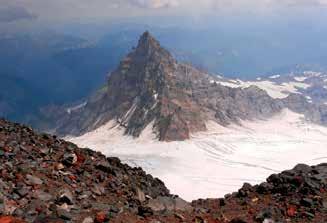
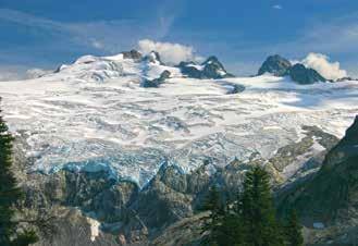
20 At the intersection of three continental plates, the Pacific Northwest was built by fire and sculpted by ice and water. It is a is story written in stone, more than one billion years in the making. The proof is under your hiking boots. Telling the complete story of Washington's geologic history could easily fill this entire magazine or ten magazines. It is an extremely complex tale one that involves colliding land masses, ocean floors rising into mountains, volcanic eruptions, ice age glaciers and catastrophic floods. It involves terms like fluvial deposits, flood basalts and tertiary plutons. But you don't need to hold a degree in geology to identify and understand how some of your favorite landscapes came into being. You just need to know a few common terms and what to look for. It's likely you may even already be familiar with some. The next few pages illustrate some of the more common glacial and volcanic features you're likely to see on many of your favorite hikes, as well as the terms used to identify them. Once you have a better idea of what you're seeing not just a pretty valley or high mountain peak you re bound to appreciate your favorite landscapes even more. PHOTOS, LEFT TO RIGHT, FROM TOP: The rocky spire of Little Tahoma, flanked by Emmons and Ingraham glaciers, Mount Rainier. Stepped cirques and tarns of Venus and Spade lakes, Alpine Lakes Wilderness. The narrow arête of the Knife Edge Traverse, Goat Rocks Wilderness. Glacier-capped Mount Adams, Washington's second-highest dormant volcano. The Goat Lake cirque in the remains of an ancient volcano, Goat Rocks Wilderness. Mount St. Helens crater and still-active lava dome; by Kathy Lashier. The 2-mile-wide, mountain-carving Challenger Glacier, North Cascades; by Andy Porter. Icefall and seracs on the Winthrop Glacier, Mount Rainier; by Robert Nowak. Lava plateau and coulee, Goose Lake; by David Hagen Heavily weathered columnar basalt wall, Potholes Coulee; by David Hagen. The basalt volcanic plug of Beacon Rock, Columbia River Gorge; by Ryan Ojerio. Lake Ingalls tarn, Alpine Lakes Wilderness. Spider Meadow's wide, U-shaped glacial valley, Glacier Peak Wilderness. Photos by Doug Diekema, except where noted. TITLE PHOTO: The striped pattern in the Hiking Rocks title above is actually a rock formation found in Washington. Can you guess what and where it is? Story by Nature Narration by Eli Boschetto Illustrations by Lindsay Holladay 20 Washington Trails Jul+Aug 2014 wta.org


21 Washington Trails Jul+Aug 2014 wta.org 21

 As you hike those valleys and ridges to your favorite lakes and meadows, can you ascertain exactly how the scene before you came to be?")

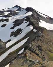
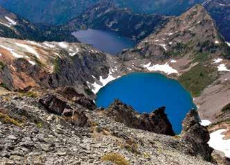
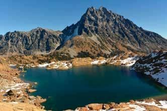
22 GLACIAL GEOLOGY Take just about any hike in the Cascades or Olympics, and you are likely to observe a landscape dramatically shaped by moving ice. Glaciers have been sculpting Washington s mountains since the ice age, and continue to do so. Washington is home to the largest assembly of glaciers albeit most of them retreating in the lower 48 states. (Alaska has the most glaciers in the U.S.) As you hike those valleys and ridges to your favorite lakes and meadows, can you ascertain exactly how the scene before you came to be? The following collection of terms and descriptions can help you identify many of the common glacial formations seen on trails throughout Washington s mountain ranges. By recognizing many of these simple features, you can gain new insight and appreciation for the power of nature and its ability to sculpt a landscape. Cirques French for arena, a cirque is a wide, bowl-shaped hollow often found at the head of a valley or high on a mountain ridge. Cirques are formed by the development of a glacier in a natural depression, where weathering and its own erosional forces carve out the shape. Many valley glaciers originate from cirques. Once the glacier is gone, all that remains is an amphitheater-like opening, often with a lake (tarn) at the bottom, held in by a natural dam (moraine). A cirque may also be referred to as a corrie or cwm. (1) CIRQUE HIKE: On the east side of the North Cascades, Lake Ann is in one of the most accessible and picturesque cirques in Washington. Once filled with a large glacier, the basin now contains a pretty lake surrounded by high, rocky walls. The trail climbs gradually along the northern wall to a high ridge (arête) above the lake. From this vantage, you can imagine the basin below once filled with ice flowing into the lower valley. DISTANCE: 8 miles GAIN: 2,000 feet MAP: Green Trails 49, 50 Moraines A moraine is any accumulation of rock or debris (till) deposited by an advancing or retreating glacier, most often in the form of ridges. Ridges that form parallel to glaciers are lateral moraines, ridges that form between two glaciers in one valley are medial moraines, and ridges that form at the ends of glaciers are terminal moraines. The material deposited into moraines may be the result of the glacier picking up rock as it advances or retreats, or avalanche deposits as the glacier erodes the valley walls. (2) MORAINE HIKE: Emmons Moraine in Mount Rainier s White River Valley displays an exceptional example of a variety of glacial moraines. The ridge the trail ascends is a lateral moraine. Down the valley, just beyond the turquoise-colored lake, is a terminal moraine, marking the extent of Emmons Glacier during the little ice age. The valley plain below is a ground moraine, associated with glacial retreat. (See more about this hike on page 53.) DISTANCE: 3 miles GAIN: 400 feet MAP: Green Trails 269S Tarns A tarn is a lake or pool in a cirque or depression once occupied by a glacier. The water in a tarn is typically rainwater or snowmelt. Many of the alpine lakes throughout Washington s Cascades can be classified as tarns. A major difference between a lake and a tarn is that tarns often fill depressions in bedrock carved out by a glacier, whereas lakes can fill basins or valleys created by other erosional or geologic processes. Lakes often fill sedimentary basins where running water pools and enlarges its area. (3) TARN HIKE: You can see several gorgeous alpine tarns in Olympic National Park s Upper Royal Basin, including the brilliant Imperial Tarn. The high basin at the head of this glacial valley is punctuated by hanging cirques and ringed by sheer, rocky walls (arêtes). The turquoise color of Imperial Tarn (and many other lakes and tarns in Washington) is created by rock flour, the ultra-fine particles of ground-up rock created during glacial erosion. DISTANCE: 15 miles GAIN: 3,250 feet MAP: Green Trails Washington Trails Jul+Aug 2014 wta.org


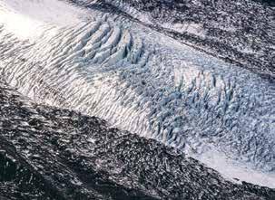
23 The Surface of a Glacier Crevasse A surface crack on a glacier produced by its movement down a mountain slope or bending through a valley. Icefall A series of parallel crevasses created when moving over an escarpment or cliff; often resulting in a field of seracs. Sérac Pinnacles of ice created on a glacier's surface when broken by flowing over an escarpment; often in icefalls. Aretes When two glaciers carve out parallel valleys, the narrow ridge formed between them is called an arête. Arêtes can also form where two cirques occur back-to-back. Once the glaciers are gone, continued erosion and mass-wasting often cause these ridges to become steeper and narrower, commonly referred to as knifeedge ridges. Where a glacier flows down a valley and is split by a ridge into two parallel valleys, that ridge, which will become an arête, is called a cleaver. (4) ARÊTE HIKE: One of the most stunning sections of the Pacific Crest Trail (PCT) in Washington, through the Goat Rocks Wilderness, is actually atop an arête, appropriately named the Knife Edge Traverse. From the flank of Old Snowy, north to Elk Pass, the PCT skirts the narrow ridgetop between the Lake Basin to the west and the McCall Basin to the east. Johnson Peak is the high point of another arête dividing the Lake Basin from the Lily Basin. DISTANCE: 21 miles GAIN: 3,000 feet MAP: Green Trails 303S More Glacial Geology Features Col A low point on a glacially eroded ridge or arête, or between opposing cirques; also referred to as a saddle; often utilized as a mountain pass. (5) Erratic Any size rock transported from its original location and deposited in a distant location by an advancing or retreating glacier. (6) Glacial Trough Formed when a glacier scours and widens a narrow river valley; commonly referred to as a U-shaped valley. (7) Hanging Valley A tributary glacial valley that has not eroded to the same depth as the main glacial valley; often the location of a waterfall. (8) Horn A pointed or pyramidal peak resulting from multidirectional glaciation, often at the head of three or more cirques. (9) Till The unsorted rock material collected by a moving glacier and deposited upon retreat, usually resulting in moraine formation. (10) Washington Trails Jul+Aug 2014 wta.org 23


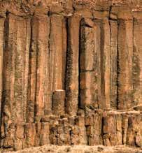
24 VOLCANIC GEOLOGY Before the glaciers, there were the volcanoes. Washington s volcanic nature is directly related to its location where tectonic plates converge, specifically where the Pacific and Juan de Fuca Plates subduct under the North American Plate. At this convergence, deep underground, rock is melted, rises and is occasionally released onto the surface sometimes passively as surface lava flows, sometimes violently as explosive, mountain-building or mountain-destroying volcanoes. Washington is home to five active volcanoes, as well as a variety of other smaller volcanic features. Some of your favorite trails may traverse, climb or circumnavigate these formations. But while you may be able to recognize a volcano or lava flow, knowing how and why it occurred opens up a new awareness of how the Northwest was created literally from the ground up. Calderas Like giant sinkholes, calderas are the depressed areas created following a volcanic event. These usually occur where magma has been expelled, leaving an empty space for surrounding rock to settle in. Calderas can range in size from nominal summit craters on volcanos to large-scale depressions where an entire mountain is destroyed by the eruption most notably in the Northwest, Crater Lake. Massive calderas can even fill entire valleys, as in California s Long Valley Caldera and Wyoming s Yellowstone Caldera. (1) CALDERA HIKE: From Artist Point on Mount Baker a cornucopia of volcanic scenery the Chain Lakes Trail contours the head of Swift Creek Valley, an ancient caldera. Little more than one million years ago, a violent eruption occurred in this location before Mount Baker was even a mountain. When the ash settled, the surrounding landscape collapsed to fill in the area. The depression was later carved out by glaciers, forming the current landscape. DISTANCE: 8 miles GAIN: 1,600 feet MAP: Green Trails 14 Hummocks Often resembling a lumpy, out-of-place jumble of mounds and cones, hummocks are the deposits resulting from landslides and avalanches. Their composition is often a mixture of shattered rock and debris in the case of volcanoes, often layered lava flows that was at one time part of the mountain s flank or summit. The 1980 Mount St. Helens eruption produced one of the largest landslides in modern history. One of the results of this landslide was a large deposit of hummocks in the debris field below. (2) HUMMOCKS HIKE: Get an up-close view of volcanic hummocks on the aptly-named Hummocks Trail on Mount St. Helens. Many of these mounds are chunks of rock blasted off the mountain s summit. Due to the varied mineral nature of the original rock, the crumbly mounds display a range of colors. As the area has recovered from the effects of the eruption, a wetland area has developed in and around the hummocks. DISTANCE: 2.3 miles GAIN: 100 feet MAP: Green Trails 332 Columnar Basalt One of the more curious volcanic rock formations is columnar basalt. Basalt is an extremely dense, fine-grained rock usually high in iron content. As basalt lava begins cooling into rock on or near the earth s surface, the new rock begins contracting and forming cracks or joints at equal distances from the cooling points. The cracks are then spread vertically through the cooling lava, resulting in the columnar shape. Exposed formations of columnar basalt can be quite remarkable. (3) COLUMNAR BASALT HIKE: There are many fine examples of columnar basalt in the Columbia River Gorge, due in large part to the work of rivers and floodwaters carving away surface materials and exposing the underlying rock. A unique example is the Catherine Creek Arch. This heavily weathered columnar basalt wall eroded away in one spot, creating a large natural arch. More interesting basalt formations can be seen at the nearby Coyote Wall. DISTANCE: 2.3 miles GAIN: 370 feet MAP: Green Trails 432S 24 Washington Trails Jul+Aug 2014 wta.org
 A thick, slow-moving lava flow characterized by blocky lava fragments (clinkers) carried along the top.")


25 Types of Lava There are many types of lava and lava rock, largely depending on the mineral composition of the molten magma. These are the three most common forms of lava. A a ( ah-ah ) A thick, slow-moving lava flow characterized by blocky lava fragments (clinkers) carried along the top. Pahoehoe ( pah how-ey-how-ey ) A very fluid-like, silvery lava flow, often with a smooth or ropy surface texture. Pillow A jumbled, billowy lava flow extruded under water, often on the ocean floor at vents and mid-ocean ridges. Lava Tubes When fluid lava (pahoehoe) flows down a volcano, the surface of the flow cools and hardens first, often forming a lava tube inside. This insulated conduit allows the lava within to continue flowing downhill. When the lava has drained out or ceased flowing, an empty tunnel is left behind. Depending on the size and duration of the lava flow, tubes can be single large tunnels or complicated networks of overlapping and intertwining passages. Hawaii s Kazumura Cave is the world s longest lava tube at 40.7 miles. (4) LAVA TUBE HIKE: On the south side of Mount St. Helens, Ape Caves is a 2.25-mile lava tube. Visitors gain entrance via skylights in the middle or upper sections of the tube. Inside, the ceilings are adorned with lavacicles, where droplets of lava cooled and hardened and resemble mini stalagmites. In the upper cave is an 8-foot lavafall, and in the lower cave is the meatball, a large rock suspended between the narrow walls of the tube. DISTANCE: miles GAIN: 300 feet (upper cave) More Volcanic Geology Features Bomb A half-molten lava fragment expelled during a volcanic eruption; often takes a football-like shape as it cools while hurtling through the air. (5) Cinder Cone A steep, unconsolidated hill of gas-bubbly cinders or scoria; often found on the flanks of larger volcanoes. (6) Fumerole A gaseous vent that occurs over a magmatic heat source, usually emanating from fissures; often has a sulfurous rotten egg smell. (7) Lava Bed An accumulation of lava rock, typically extruded non-explosively, from a surface vent or fissure; often associated with shield-type volcanoes. (8) Lava Dome An extremely viscous lava extrusion that expands and grows over a concentrated area instead of flowing down a mountainside. (9) Lava Plug The hardened core of a volcanic vent, revealed when the surrounding rock is eroded away; often mound or spire-like in formation. (10) Washington Trails Jul+Aug 2014 wta.org 25

26 Hiker is not the first thing most people think of when they catch a glimpse of Bob Rivers. After all, he often sports a leather jacket and tops his long silver hair with a pageboy hat. The look is more urban hipster than mountain man. But don t let any of that fool you. Bob is a trekking fanatic, known to seek out quiet places where he can recharge and take in the azure sky from high country. His love for trails started early just like his love for radio. [1] Hooked on Hiking Bob s first experience in the backcountry came courtesy of an Eagle Scout best friend who challenged Bob into climbing to the top of a local Connecticut peak. I still remember that first time he dragged my slow, lazy rear to the top of a mountain, he said. I remember the feeling of elation when I saw the vista at the overlook. I felt like I was on top of the world! From that point on, Bob was hooked. Today when I see people experiencing their aha moments on beautiful panoramas like Rattlesnake Ledge, I relive that feeling, he said. Bob doesn t just enjoy hiking. He also lights up when he talks about sharing the experience with others. On a recent trip, he guided his two radio co-hosts, Spike and Downtown Joe, up Rattlesnake Ledge and was elated to see their joy. They d never been there, he said. They both eschew that kind of climbing and exercise. I was proud of them both. [2] Loving the Radio About the time Bob had his first experience with hiking, the seed for his legendary career was planted. It came in the form of a transistor radio from his grandfather. Young Bob only seven years 26 Washington Trails Jul+Aug 2014 wta.org

27 o Radio Host o Musician o Philanthropist o Hiker Washington Trails correspondent Tami Asars recently sat down with the Seattle radio legend to talk about life as a rock DJ, moving to the Pacific Northwest for the hiking and giving away concert tickets from the Granite Mountain Lookout old was hooked from the moment he turned on the power. Grandpa let me listen to that radio for as long as I wanted, and he had plenty of batteries, which was a big deal because they were costly back then, he said. Bob quickly learned that radio shows offered prizes. The first weekend he owned the radio he was caller number 10 to pay phone trivia, a game show that required the contestant to identify by sound alone the amount of money being dropped into a pay phone. All I heard was a pile of noise, said Bob. But my grandfather was listening in when the coins started to drop. Since I had no idea about money, he whispered the answer in my ear. Bob s shout of 85 cents! was met with a radio jingle announcing he d won. From then on, he was glued to the radio, playing every contest he could. As a teenager, he started a high school radio station and did shifts at WYBC. He continued his radio work in college at Yale University. Today, Bob has been on the air for more than 42 years. [3] Smitten by Seattle Bob s career in radio and his love of hiking grew concurrently. He discovered trails wherever his jobs took him. In the beginning that meant hiking on the East Coast, in the scenic White Mountains, Mount Washington and Franconia Notch. Bob was enamored with the destinations he discovered but disliked the long drives that were necessary to get to his favorite playgrounds. When a job opened up in Seattle and Bob was informed that trails and mountains were close to the city, he couldn t believe his ears. Considering he d never even seen a picture of the place before, he decided on a trip to check out the radio station and see the hiking opportunities firsthand. As luck would have it, the skies were crystal clear (and deceptively dry) that day in April Because all Bob ever talked about was mountains and trails, the station manager helped Washington Trails Jul+Aug 2014 wta.org 27

28 persuade him to take the job by whisking him up in a helicopter and flying him over the Cascades. Bob was smitten. He rushed home to tell his wife, Lisa, about the scenery and recreation he d discovered. They both agreed the foothills around Seattle were the perfect place to raise their family. It wasn t long before they settled in North Bend, where Bob could easily access trails to Rattlesnake Ledge and Mount Si. Twenty-five years later, he still hikes his favorite local peaks several times a week. He likes competing with himself for time, especially on the trail to Rattlesnake Ledge. My fastest time to the second ledge where I enjoy going to get a bit more solitude is about 34 minutes. The day I set that personal record, I made a mistake. I ran down. Word to the wise: If you are of certain age, gravity is not your friend. I was in super-fit shape and thought I was invincible. But my right foot caught something and I went airborne. Time went in slow motion as I flew uncontrolled through the air. It took me a couple weeks to get over the soreness. Since then, I walk down! [4] Giving Back When Bob s not on trail, he s on the radio. The Bob Rivers Show, (weekdays from 6am to 10am Pacific Time on radio station 95.7 KJR-FM) has made its mark by entertaining the Seattle market with amusing guests, lighthearted pop culture discussions, current events and news, sports updates and hilarious song parodies. But it s not all fun and games. Bob is passionate about charity and uses his radio platform to give back to the community. His show hosts regular World Vision radiothons and has already improved the lives of thousands of kids. This year, Bob will be spending the month of August raising money for WTA and trails as a first-time Hike-a-Thoner. Giving back especially to support causes he s passionate about is something that brings Bob a lot of joy. My charity work might actually be the best thing I ve ever done, he said. It s hard to imagine anything being more important. In addition to raising money, Bob loves to volunteer. His stint with the U.S. Forest Service always brings a smile to his face. As a volunteer ranger I worked on the Pacific Crest Trail near Snoqualmie Pass, he said. The experience taught him a lot. I learned about fragile ecosystems and why we need to practice good outdoor ethics. I learned about some of the painstakingly difficult challenges that go into trail maintenance. And I learned that the people who put so much effort into trails really care about the land and about providing us with a quality outdoor experience. We have an amazing network of trails! [5] Hiking for Tickets At times, Bob s passions charity, hiking and radio have been combined for humorous results. With a bashful laugh, he recounts one such instance. It s a little embarrassing, but I feel the perhaps I shouldn t have done this statute of limitations has run out, so I can share it, he said. Several years ago, one of Bob s duties as a volunteer ranger was to resupply the Granite Mountain Lookout with camp necessities. As a reward for schlepping things like heavy propane tanks to the summit, he was offered overnight stays in the grand tower. On one As a volunteer ranger I worked on the Pacific Crest Trail near Snoqualmie Pass. I learned about fragile ecosystems and why we need to practice good outdoor ethics. 28 Washington Trails Jul+Aug 2014 wta.org


29 such occasion, he was over halfway up the peak when he realized he d forgotten a work commitment. The radio station where I worked had tasked me with giving away some Pearl Jam tickets that day. The promotion was called a ticket-blitz and involved going somewhere such as a bar, supermarket or park broadcasting the location, and giving away tickets to the first three people who showed up. This was 1992 and during that time, Pearl Jam was on fire. The concert tickets for their Drop in the Park event were in high demand. Life was busy and I had a lot of things going on, but I was so excited about spending the night in the lookout tower that I set off for the hike without much thought. About halfway up, I remembered that I had the Pearl Jam tickets for the ticket-blitz in my pocket! So when I got to the top, I used my cell phone and called the radio station to broadcast: All right, I ve got your Pearl Jam tickets and I m sitting on top of Granite Mountain. Please do not try this if you are not a hiker, and please do not try this if you will feel disappointed, because only the first three hikers will get a pair of tickets. I will warn you that it will take you several hours to get up here. Good luck. With an uneasy feeling, because he was on duty in his official Forest Service uniform, Bob sat and waited. He hoped the ticketblitz would inspire folks to hike, and sure enough it did. About three hours later some guy came huffing and puffing, Bob said. I congratulated him and gave him the tickets. A couple came next and scooped up a pair. Then I started to worry that I might get flooded with people hoping for tickets and that I d have to turn them away. The story ends well, though, because only three groups came up, and I had a pair of tickets for every one of them. I m pretty sure I was given a talking-to by the powers that be about being on the radio and pulling that shenanigan. [6] Checking off the Bucket List Despite his busy schedule, Bob continues to volunteer with various charities, hike as much as humanly possible and faithfully open the airwaves at the crack of dawn to entertain listeners. In a few months, he ll become a grandfather for the first time. It s a role he can t wait to tackle. Starting when I was five, my grandfather played an important role in my life by inspiring me to follow any dream I had. I look forward to giving my grandkid that same kind of encouragement. And hiking with my grandchild? That would be a great reason for living and a complete thrill! Another thrill for Bob: continuing to check things off his hiking bucket list, which includes Mount Rainier s Wonderland Trail and treks in Costa Rica, the Grand Canyon and Crater Lake. But don t expect him to stop hiking in his own backyard. It s something he feels strongly about. As I continue to enjoy my backyard trails, I look forward to discovering new ones and repeatedly being wowed by Washington state, he said.è Story and photos by Tami Asars Rockin Rivers Top-Ten Hiking Playlist 1. Love, Reign O er Me The Who 2. Give Up the Funk Parliament 3. Father and Son Cat Stevens 4. Roundabout Yes 5. Magazine Heart 6. Spill the Wine Eric Burdon and War 7. Jump into the Fire Harry Nilsson 8. Crimson and Clover Tommy James 9. Dixie Chicken Little Feat 10. Boogie on Reggae Woman Stevie Wonder Washington Trails Jul+Aug 2014 wta.org 29


30 By Paula MacKay August 2012, Glacier Peak Wilderness As my husband, Robert, and I approached our first research site of the day, I immediately noticed that the lure pile a crude teepee of sticks slimed with cow blood and fermented fish had seen some serious action in our absence. What once resembled a Boy Scout bonfire had collapsed into a jumble of branches more akin to an eagle s nest. Probably black bears, I told myself as I sat down to review the images captured by our motion- triggered camera. I didn t want to get my hopes up this soon in the trip. Although it was a treat seeing photos of any animals, we were after something specific: grizzly bears. As part of a collaborative team of field biologists, our goal was to confirm the presence of the seldom- seen animal in Washington s North Cascades ecosystem. We d already spent much of the summer (not to mention the previous three) lugging hefty survey gear up thigh- burning trails, and were admittedly disappointed to have detected no grizzlies so far. Maybe our luck was about to change. While Robert tended to the hair- snagging devices centered around our now- destroyed lure pile, I began scrolling through the pictures. I decided to look at the most recent trigger events first and work backward. Event #4: Yup, just as I suspected: a big ol black bear snuffling around our pile. And the time stamp indicates he was here just this morning! Event #3: Another black bear. Slightly smaller, brown coat. Event #2: Aw, a marten. They re so cute even if they do eat squirrels and pikas for breakfast. Event #1: Whoa, isn t that a...? Illustration by Lindsay Holladay Rob! I exclaimed in a tone that must have conveyed grizzly bear given the height of his eyebrows when he turned my way. I tried to hold back until he could see the photos for himself, but I couldn t stop myself from blurting out, We got a wolverine! 30 Washington Trails Jul+Aug 2014 wta.org


31 Needless to say, we were both very excited in our search for wilderness icons, wolverines were one heck of a consolation prize. On the camera s display screen, we watched the wolverine roll around in the lure pile like a puppy that had just discovered cow patties for the first time. His snowshoe-like paws pointed skyward as he rubbed his back in the woody debris. Suddenly the wolverine stood up and showed us his broad, bearish head and bushy tail, but only for a moment. Then he was spinning around on his rear end again. This frenetic routine continued for a full two minutes before he finally left the stage to resume his life as a respectable wolverine albeit a very smelly one. Little did he know that his antics were caught on camera. Or that he d left us a few stray hairs in the process. Those hairs yielded a lot of information once they were sent to the U.S. Forest Service s Wildlife Genetics Laboratory in Montana for DNA testing. When the results came back, we learned that the wolverine we photographed was previously unknown to biologists a new kid on the block and only the second to be documented west of the Cascade Crest in recent years. (The first was at Sauk Mountain, just north of Rockport, earlier that same summer. DNA and photos showed they were two different animals.) But the news got even better. It turns out that our visitor reflected a surprising trend in Washington s wolverine population. Absent for much of the last century, wolverines are now thought to be reclaiming their former range in the North Cascades. Vilified Weasels Wolverines (Gulo gulo) are the largest and most enigmatic terrestrial members of the mustelid, or weasel, family, a feisty group whose other North American members include badgers, ferrets, fishers, martens, minks, and river and sea otters. Ranging in size from beagles (females max out at around 26 pounds) to border collies (males typically weigh up to 40 pounds), and capable of fending off much bigger predators (even grizzly bears!), wolverines are widely considered a top dog in the toughness department. Although wolverines have long been considered cantankerous loners, biologists have discovered that they do have a sociable side, with two or more wolverines occasionally seen traveling and playing together. However, when it comes to meal time, their reputed nature for being feisty and tenacious is revealed. A wolverine can take down animals as large as a deer or a tired elk. But most of a wolverine s winter diet comes from the frozen food section packaged as carrion buried in snow. In summer, small mammals dominate the menu. Persecuted by Trappers The wolverine s adeptness at sniffing out a good meal didn t sit well with marten trappers who were trying to supply the voracious fur market of the 1800s. Wolverines in the North Cascades weren t significant targets for the fur trade they were too coarse-haired, scarce and difficult to access. But they were heavily persecuted for raiding traps. One regional trapper named Charles Greenwood captured the tension between trappers and wolverines in his 1894 article, The Wolverine at Home. Greenwood spent the winter of working trap lines from a cabin near Lake Chelan. He described with both consternation and admiration how one after another of his traps had been robbed by wolverines (aka gluttons) seven of whom had lost their hides to Greenwood by spring. Although Greenwood and other trappers credited wolverines with shrewdness and courage, neither trait could shield them from the snares and poisons that peppered post-settlement Washington. By the mid-1900s the wolverines were gone. Identifying Wolverines If you look at an animal and you can t for the life of you figure out what the heck it is, says Doug Chadwick, author of The Wolverine Way, it just might be a wolverine! According to Chadwick, the wolverine s shape and unique gait set it apart from other wildlife. If the animal you re looking at is really round, it s a marmot, he says. A distant coyote is going to be trotting with its back on a level plane, versus the up- and- down, bumpety- bump lope of the wolverine. Bear cubs are another potential source of confusion (wolverines are sometimes called skunk- bears), but wolverines have more of a humped back and rolling gait. Broad head with small eyes and small, rounded ears Light-colored band that extends from shoulder to rump Humped back that bobs up and down as it walks Bushy tail Like lynx, wolverines have supersized feet designed to help them float across deep snow. Says Chadwick: In the rare times that you actually see a wolverine just walk, the feet are so big and at the end of such surprisingly long legs that they have to kind of swing them out to the side. They move like some kind of really awkward porcupine probably lower to the ground than you imagined. Huge feet with curved, semi-retractable claws Photo by Steven Gnam Washington Trails Jul+Aug 2014 wta.org 31


32 Wolverines in Washington Between 2000 and 2013, there have been 34 reliable wolverine records in Washington outside the study area boundaries, indicating that wolverines are extending their range beyond the North Cascades. They have been documented in the Glacier Peak, Goat Rocks and Mount Adams areas, and there is even one record far to the east in the Kettle Range. Information provided by Keith Aubry and Cathy Raley, U.S. Forest Service, unpublished data. Range of wolverine study in Washington Additional wolverine records in Washington On the Rebound It wasn t until the 1960s that the state experienced a small surge in wolverine activity. Dr. Keith Aubry, a research wildlife biologist with the Forest Service s Pacific Northwest (PNW) Research Station and a leading expert on mustelids (weasels), attributes this surge to a push from wolverines north of the border. Still, the population didn t really begin to rebound until the mid-1990s. About that time, we started to get a number of verifiable reports of wolverines in the North Cascades, Aubry says. The increase in reliable accounts was sufficiently dramatic that it couldn t simply be attributed to more people being out in the backcountry. In 1997, a young wolverine was struck and killed by a vehicle west of Mount Baker, and in 1998, a remote camera photographed another animal near Hart s Pass. Wolverines appeared to be recolonizing some of the habitat left vacant since the heyday of trapping. In 2005, Aubry, wildlife biologist Cathy Raley, and other colleagues launched the North Cascades Wolverine Study the firstever study of wolverines in the Cascades. Thanks to the 14 tenacious wolverines captured, tagged, and released since Melanie, Rocky, Chewbacca, Xena, Sasha, Eowyn, Mattie, Mallory, Dasher, Logan, Chance, Kendyl, Special K and Hobbes scientists now have a better understanding of where they came from (probably coastal British Columbia), how they make a living in the jagged peaks of the North Cascades (the hard way) and what their future might look like in the warming climate of the Pacific Northwest. Playing Dress Up With Technology John Rohrer, range and wildlife program manager with the Forest Service in the Methow Valley, and Scott Fitkin, district wildlife biologist with the Washington Department of Fish and Wildlife, are no strangers to tracking wolverines. For the last nine winters, they and other members of Aubry s team have monitored these animals in some of the wildest country the Cascades have to offer. The task has been made all the more challenging by the fact that a male wolverine s activity area can encompass more than 1,100 square miles an area about the size of Yosemite National Park. Summer typically isn t favored for wolverine research because baited survey stations are vulnerable to bears. To track their movements, the research crew fits each wolverine with a high-tech collar containing satellite and radio transmitters. But playing dress-up with a grumpy wolverine is easier said than done. First researchers build a box trap out of heavy logs. Next they bait the trap with a dead beaver, wild salmon or a healthy slab of venison. Then they wait to see who shows up for dinner. With modern electronics, Rohrer and Fitkin can listen for the doorbell from the comfort of their own living rooms many miles away a remote transmitter sends them an message as soon as the trap lid closes. Exactly who triggered the lid remains a mystery until crew members snowmobile in to the site. It s not uncommon to find a satiated marten or a short-tempered lynx in need of catnip sitting in the trap. If they re lucky, a wolverine is the guest of honor. Given their preference to eat and run, most wolverines don t appreciate being confined to tight quarters after a meal. If you didn t know better, you d think there was a 500- or 600-pound grizzly bear stuffed into that little box! says Fitkin, who has approached more than his share of wolverines suffering from cabin fever. The wolverine s low-pitched, guttural growl can be so intimidating, in fact, that one rookie team checked traps while still wearing their snowmobile helmets, visors down. Certain wolverines will very predictably bluff-charge the front of the trap, Fitkin adds. You can t help but jump back, even when you know it s coming. Each captive wolverine is sedated, weighed and measured, and given identification tags and a tracking collar. The whole process takes up to 45 minutes, after which the animal is returned to the trap until it has fully recovered and can be sent on its way. Such high-adrenaline captures have yielded huge payoffs. In April 2012, the North Cascades Wolverine Study located the first two reproductive den sites ever documented in the Pacific 32 Washington Trails Jul+Aug 2014 wta.org


 has proposed that wolverines in the lower 48 be listed as threatened under the Endangered Species Act.")


33 Northwest, after Raley zeroed in on where to look for them using telemetry data. Wolverine dens are typically tunneled into snow, which helps keep young kits safe from other predators and frigid weather. One of the dens was still occupied by mother Xena and her kit; the second mother, Mallory, had already vacated her den by the time it was found by the research team. Fighting to Stay Alive Roughly 250 to 300 wolverines remain in the U.S. outside of Alaska, with most of them inhabiting the Northern Rockies, and an estimated 25 to 50 roaming the North Cascades. Because denning wolverines need snow that lasts into late spring and with climate change models predicting reduced snowpack and earlier spring snowmelt in the future the U.S. Fish and Wildlife Service (USFWS) has proposed that wolverines in the lower 48 be listed as threatened under the Endangered Species Act. Like polar bears, wolverines may stand little chance against rising global temperatures. Scientific models indicate that wolverine habitat in the West could shrink by as much as one-third by 2060 and two-thirds by the end of this century if current trends in global warming continue. These projections also suggest that extensive areas of persistent spring snow cover in the North Cascades will provide increasingly important refuge for wolverines as habitat elsewhere disappears. The USFWS is expected to decide on the wolverine s legal status this summer. Meanwhile, Robert and I have been bitten by the wolverine bug, which tends to induce feverish delusions that we can follow these extreme mountaineers into their near-vertical terrain. In 2013, we helped initiate a project (with the PNW Research Station and Seattle s Woodland Park Zoo) to pilot-test a summer monitoring protocol for wolverines in the North Cascades. Chasing a growing population of wolverines through the snow isn t logistically feasible over the long-term even with pros like Rohrer and Fitkin on the job. The crew will be out there again in the summer of 2014, deploying remote cameras and trying to snag hairs from passing wolverines. Who knows? Maybe now that we re looking for wolverines, we ll find a few grizzly bears.è Where to Find Wolverines Washington s wolverines typically reside in snowy alpine areas. In the summer months, hikers should scan open areas in the high country, particularly areas populous with marmots and ground squirrels. Wolverines have also been spotted using the same travel routes hikers do, so be watchful on ridges and passes. If you happen to meet a wolverine on the trail, you have little to fear. Just remain where you are and let the animal pass. Don t lie down and play dead, advises Doug Chadwick. They love dead stuff. Kidding aside, Chadwick says you shouldn t worry about being attacked. There has never been a case of a free- roaming wolverine attacking a human. If you are fortunate enough to see a wolverine in Washington, please contact the North Cascades Wolverine Study at kaubry@fs.fed.us. And don t forget to take photos! If you re interested in volunteering to help document wolverines with motion-triggered cameras, you can contact Alison Huyett at Conservation Northwest: Alison@conservationnw.org or Celebrate HIKING with WTA on August 2 Bring a friend hiking, or hike a trail you've never done before. Show off your WTA on trail and you may get a trail treat from WTA staff. Instagram your hiking high-five for a chance to win a tent from The North Face! Visit WTA online for more information on the second annual Washington Trails Day, and how you can participate in the trail treats and Instagram tent contests. PAULA MACKAY was drawn to the Pacific Northwest from her native New England by big mountains and large carnivores. She and her husband Robert Long have studied carnivores together for more than a decade, and co-edited the book Noninvasive Survey Methods for Carnivores (Island Press, 2008). MacKay is currently earning an MFA in creative nonfiction at Pacific Lutheran University. wta.org/watrailsday One Instagram photo will be selected as the winner of a Talus 3 Tent, courtesy of The North Face. See website for full contest rules, eligibility and dates. Washington Trails Jul+Aug 2014 wta.org 33

34 "LIKE MUSIC AND ART, LOVE OF NATURE IS A COMMON LANGUAGE." 34 Washington Trails Jul+Aug 2014 wta.org
35 Not bad for a front porch view. Being a good steward of wilderness includes following the principles of Leave No Trace and camping in designated camping areas or on durable surfaces in order to leave minimal impact on the environment. Photo by Buff Black. Stewardship As the 10-Year Wilderness Stewardship Challenge nears its end, on the eve of the 50 th anniversary of the Wilderness Act, our wilderness areas are still in need of some work from both the agencies who manage them and the public who uses them. In 2005, Dale Bosworth, then chief of the U.S. Forest Service, issued a challenge: to pass wilderness areas to the next generation in better condition than when they were designated. In addition to reviewing policies affecting fire intervention, invasive plant control and air quality, Bosworth s 10-Year Wilderness Stewardship Challenge aimed to review and rate recreation sites trails, trailheads and campsites. Each wilderness area administered by the Forest Service (approximately one-third of total wilderness areas in the U.S.) was analyzed to determine whether they were sufficiently pristine, and whether future generations would be bequeathed wilderness-quality recreation. The Wilderness Act states that wilderness is to be managed for the enjoyment of the American people in such manner as will leave them unimpaired for future use and enjoyment as wilderness. But as more and more people head into wild areas seeking refuge and recreation, this goal tasks land managers with finding the proper balance between access and preservation in an era of declining budgets and decreasing workforces. This puts even more responsibility on wilderness users to be stewards of these lands by practicing proper wilderness ethics and volunteering to assist in their maintenance and protection. Around the same time as the implementation of the Wilderness Act, the Forest Service introduced Leave No Trace (LNT). This was done as an effort to encourage stewardship among the public and backcountry users in a time when wild areas were being abused and neglected. It introduced an opportunity for the public to take a sense of pride and ownership in the nation s wilderness areas as part of the act s efforts of future preservation. The overarching concept of LNT: Leave it better than you found it, achieved by a simple list of commonsense, low-impact outdoor ethics. (See the full list on page 37.) In addition to practicing LNT and encouraging others to do to the same users can also be good stewards of wilderness by volunteering to aid in its care and preservation. This helps fill the gap in the current management system and ensures that many of our favorite wilderness trails are not loved to death or left to decay. - Jimmy Carter Washington Trails Jul+Aug 2014 wta.org 35


36 Olympic Wilderness Washington s largest wilderness area, the Olympic Wilderness area s nearly 900,000 acres encompass 95% of Olympic National Park and one of the most diverse landscapes in the United States from rugged, remote coastline to the third-largest glacial system in the lower 48 states. The Olympic Wilderness is one of the most popular wilderness destinations in North America, with nearly 40,000 overnight visitors a year, and features what Secretary of the Interior Sally Jewell claims is the world s best hike. All overnight hikes require a wilderness Camping Permit, and several of the most popular destinations require reservations. Goat Rocks Wilderness This has been one of the primary missions of Washington Trails Association for the last 20 years. To help keep access open and trails in working order, WTA has worked with volunteers young and old across the state who treasure our unique and irreplaceable wilderness areas. This work has included trail construction in the Alpine Lakes Wilderness, fire restoration in the Olympic Wilderness and trail rehab in the Salmo Priest Wilderness, as well as care and maintenance tasks in nearly every other wilderness area (in addition to county, state and national parks and national forests) across Washington. You are invited to be a steward of wilderness. Learn and follow LNT principles on your outdoor adventures. Volunteer on a trail maintenance crew and give back to one of your favorite areas. By being a conscientious user and active participant, you can join with others in helping to leave [wilderness] unimpaired for future use and enjoyment. The 100,000-acre Goat Rocks Wilderness derives its name from two extinct volcanoes, the ancestors of Mount Rainier to the north and Mount Adams to the south. Glaciation and erosion have ground down the peaks, scooped out shallow alpine tarns from the parkland-and-meadow landscape, and carved steep drainages. More than 100 miles of trails trace the high country of the Goat Rocks, including more than 30 miles of the Pacific Crest Trail. The high, thin volcanic soil is particularly prone to erosion; travelers must take care not to hasten a process millions of years in the making. AARON THEISEN is a Spokane-based outdoors and travel writer. In addition to being a Washington Trails regional contributor and helming this year s series on the 50th anniversary of the Wilderness Act, he is currently working on the forthcoming trail guide Day Hiking Mount St. Helens for Mountaineers Books. Closer to home, Aaron enjoys exploring the Inland Northwest with his wife and 2-year-old son. 36 Washington Trails Jul+Aug 2014 wta.org


37 Glacier Peak Wilderness Capped by Glacier Peak, the most reclusive of Washington s volcanic brethren, the 566,000-acre Glacier Peak Wilderness sometimes seems to defy visitors. More than a dozen of its peaks cradle active glaciers. Steep, U-shaped valleys, the paths of glaciers past, harbor thick tangles of huckleberry, blueberry and devil s club, which hinder crosscountry travel. Torrential rivers challenge travelers, none more so than the Suiattle River, which in 2003 overran its banks and washed away an access bridge on the Suiattle River Rd. Since then, access has deteriorated, but work is continuing to reopen the road and once again grant access to this unique wilderness area. Alpine Lakes Wilderness The nearly 400,000-acre Alpine Lakes Wilderness straddles the Cascade Crest, stretching from wet west-side cedar groves to arid ponderosa parkland. But it s the more than 700 alpine lakes and tarns that give the wilderness its name and reputation, luring both multiday trekkers and flip-flop-clad families to its trails. This quintessential Cascades wilderness comes at a cost: the Forest Service strictly regulates overnight stays in the Enchantment Lakes, the centerpiece of the wilderness, with a lottery system for permits. Please Practice Leave No Trace > Plan Ahead and Prepare > Travel and Camp on Durable Surfaces > Dispose of Waste Properly > Leave What You Find > Minimize Campfire Impacts > Respect Wildlife > Be Considerate of Other Visitors Wilderness Trails There s no better way to experience and appreciate the diverse wilderness areas in Washington state than to get out and explore them. Try one of these trails, or any of the hundreds of others, and maybe you ll discover a new favorite. SEVEN LAKES BASIN WILDERNESS: Olympic DISTANCE: 19-mile loop ELEVATION GAIN: 4,000 feet ELEVATION PEAK: 5,120 feet MAPS: Green Trails 133S Get your permit reservation in early to hike this trail from wet rainforest to alpine wonderland. GREEN MOUNTAIN WILDERNESS: Glacier Peak DISTANCE: 8-mile round trip ELEVATION GAIN: 3,100 feet ELEVATION PEAK: 6,500 feet MAP: Green Trails 80 Climb steeply through wildflower meadows to the historic and recently-saved fire lookout. COLCHUCK LAKE WILDERNESS: Alpine Lakes DISTANCE: 8.4-mile round trip ELEVATION GAIN: 2,200 feet ELEVATION PEAK: 5,600 feet MAP: Green Trails 209S Apply for a coveted ALW permit to camp at this gorgeous turquoise lake below Asgaard Pass. GOAT LAKE WILDERNESS: Goat Rocks DISTANCE: 12.8-mile loop ELEVATION GAIN: 2,590 feet ELEVATION PEAK: 6,800 feet MAP: Green Trails 303S Dayhike or backpack to this gem in the heart of the Goat Rocks Wilderness no permit required! Photos, from top: Bryan Wilhelm, Kim Brown, Bernice Schick, Doug Diekema Washington Trails Jul+Aug 2014 wta.org 37


38 Darrington Nestled among forested mountain peaks and rich in area history, the Mountain Loop State Scenic Byway offers access to some of the finest recreational opportunities in Washington. The reward for hiking the challenging Walt Bailey Trail besides lakes, meadows, wildflowers, wildlife and berries are wide-open panoramas of both the Cascade Range and Puget Sound. Photo by Jason Neuerburg OPPOSITE, FROM TOP: Pick up treats and reads at Mountain Loop Books & Coffee, courtesy of MLB&C; Pick a camping spot from one of the Loop s many Forest Service campgrounds, courtesy of The Camping View; Take in plenty of big mountain views on the Mount Dickerman Trail, by Ashley Gossens; Enjoy a casual romp to Boardman Lake, by Mike Morrison; Venture into the Black Chief Mine for a peek at Washington s history, by Tim Nyhus. By Lindsay Leffelman 38 Washington Trails Jul+Aug 2014 wta.org


39 ocated within the Mt. Baker Snoqualmie National Forest, the Mountain Loop Highway (MLH) is almost as well known for its historic roots as it is for outdoor activities. Steeped in the mining and logging history, the highway itself largely follows the routes of the old Everett Monte Cristo Railway and Sauk River Truck Trail. In the 1930s, as the mining and logging industries began to fade, the Civilian Conservation Corps (CCC) constructed the modern roadway and many of the U.S. Forest Service sites along the scenic byway. Today, the mountains, forests, meadows, lakes and rivers along the 55-mile MLH attract outdoor enthusiasts of all types to the area. Day 1: Go Camping Start your adventure in the gateway town of Darrington (1), 32 miles east of I-5. This is the last stop for services before reaching Granite Falls. While in town, take care of essential tasks like filling up the gas tank and picking up last-minute groceries, ice and camping supplies at the Darrington IGA. At the Darrington Ranger Station you can inquire with knowledgable staff about trail conditions and purchase trail maps and a Northwest Forest Pass. Before leaving town, stop by Mountain Loop Books and Coffee to pick up some breakfast goodies and maybe some reading material to enjoy by the campfire later. Just 3.5 miles south of Darrington is the Old Sauk River Trail (2), an ideal first stop to warm up your trail legs. Boasting lush, mossy old-growth forest, this mostly-level trail follows the federally-protected Wild and Scenic Sauk River for 3 miles to the southern trailhead and turnaround point. A new 1.2-mile barrierfree loop makes a great option for families traveling with very young children. When finished with your hike, enjoy lunch at the White Chuck Overlook (3). The picnic area, located about 7.5 miles south of the Old Sauk River Trail, features outstanding views of White Chuck Mountain and River, and has interpretive signage detailing the area s railroad and logging history. The next step on your journey is to find your weekend home. An abundance of campgrounds line the Mountain Loop Highway. Both Bedal and Red Bridge Campgrounds (4, 5) are situated along the loop, 8.5 and 25 miles respectively from the White Chuck Overlook, making either an ideal basecamp location. They re both small, with limited amenities, but offer more peace and quiet than some of the larger camps. Bedal Campground has 21 forested sites for tents and small trailers, a boat ramp for nonmotorized watercraft and a large Adirondack picnic shelter along the banks of the North Fork Sauk River. Red Bridge Campground, named for its close proximity to the crimson bridge over the South Fork Stillaguamish River, has 15 tent and small trailer sites, plus a gravel bar that invites riverside exploration. There is no water or electricity at either location, but you will find picnic tables, vault toilets, fire rings and tent pads. For more amenities check out Verlot Campground (6). CAMPING TIP: Campgrounds along the MLH fill up fast. Reserve your site in advance at reserveamerica.com. If all sites are booked, dispersed camping is allowed on national forest land. After setting up camp, and if there is still some daylight left, there is much more to explore along this stretch of the Mountain Loop. From the MLH, travel 1 mile Washington Trails Jul+Aug 2014 wta.org 39
40 up FR 49 (just north of Bedal Campground) to a somewhat steep, half-mile trail that climbs to the base of North Fork Sauk Falls (7). This gushing cascade plunges 45 feet into the river below and creates a breathtaking scene. A few miles east of the falls on FR 49 is the Harold Engles Memorial Grove Trail (8). This half-mile loop meanders through an impressive stand of giant cedars along the North Fork Sauk River. Harold Engles, a Darrington District ranger from 1924 to 1958, fought to prevent the sale of this grove to a timber company. When you ve finished exploring, return to camp and enjoy some s mores and stories around the campfire before turning in. Day 2: Take a Hike The next morning, following breakfast in camp, pack your lunch, top off your water bottles and get ready for a day on the trail. The 10-mile Walt Bailey Trail (9) is a worthwhile way to spend the majority of your day. Built entirely by volunteer effort, this rugged trail, with lots of ups and downs, rocks, roots and mud, meanders through forests and meadows and crosses rocky avalanche chutes and small streams before reaching the Cutthroat Lakes underneath the rocky summit of Bald Mountain. A maze of footpaths connects the lakes and invites exploration. Adventure-seekers can continue on the main trail another mile, scrambling to the summit of 4,851- foot Bald Mountain. Get there by driving south on FR 4030 (near the Red Bridge Campground), then east on FR Those in search of expansive 360-degree views might prefer to spend the day hiking the 8.6-mile Mount Dickerman Trail (10). The large trailhead parking area is on the north side of the MLH at milepost 27. After switchbacking through fire-scarred old growth and successive new growth, the trail alternates between patches of hemlock trees and meadows bursting with berries and wildflowers. Summit views include Glacier Peak, Mount Forgotten, White Chuck Mountain, Sloan Peak and Three Fingers. TRAIL TIP: For a family-friendly hiking option, try the Ashland Lakes Trail (11). This trip can be as short as 3.5 miles or as long as 8.5 miles. The trail is lined with firs, cedars, hemlocks, moss and wildflowers along a stretch of scenic mountain lakes. Before returning to camp for another relaxing evening, check out the Black Chief Mine (12) on the north side of the highway at milepost 18, just west of the Red Bridge Campground. With flashlights in hand, this is a fun way to take a step back in time by stepping into the 100-foot-long mine shaft. Constructed between 1900 and 1927, brothers Alf and Alton Eldred built the mine by hand but never struck it rich as they had hoped. Day 3: Explore More After breaking camp in the morning, don t be in a hurry to rush home. The trail to Boardman Lake (13) makes for a quick yet invigorating 2-mile morning hike. An easy climb under a canopy of cedar and hemlock deposits you on the shore of the lake, ringed by talus slopes and forested groves. There is ample space along the northern shore to spread out, soak in the sun or even take a chilly dip. Get to the trailhead by driving 8 miles west of Red Bridge Campground and follow a series of signed forest roads. Or, spend some more time exploring the area s history. About 4.5 miles west of Red Bridge Campground, the Gold Basin Mill Pond Interpretive Site (14) displays signs describing the history of the mill, with a floating dock that extends into the mill pond. Just 2.5 miles west of the mill pond, the Verlot Public Service Center (15), built by the Civilian Conservation Corps in the 1930s and on the National Register of Historic Places, gives visitors a look at bygone days with a small museum. A tribute to the mining and logging history of the Mountain Loop area is just across the roadway. Once you arrive in Granite Falls, after a few days of picnicking and cooking over the campfire, you re probably ready for a tasty meal and a cold beverage. For authentic Mexican dishes and fresh-made salsa and guacamole, drop in to Playa Bonita (playabonitarestaurant.com) on Stanley Street. Enjoy a hearty platter of beef or chicken fajitas washed down with one of their flavored grande margaritas. Or if comfort food sounds good, head for the Barbecue Bucket and dive into a hearty helping of tender smoked meat and top it off with their classic sides. Tasty! TOUR TIP: If you find yourself in town on a Sunday afternoon, take a tour of the Granite Falls History Museum (gfhistory.org). Experience what life was like a century ago by walking through the Sharp House and study the museum s artifacts to learn about the industrial, educational, and recreational history of the area. With so many recreational opportunities on such a short tract of scenic roadway, you could tour the Mountain Loop Highway over and over again and still not experience all that it has to offer. From developed campgrounds to backcountry sites, from short, kidfriendly paths to long, rough-and-tumble trails, and from singleday outings to multi-day trips, this scenic byway really does have something for every type of adventurer.è For more information on the trails on the Mountain Loop Hwy, visit fs.usda.gov/main/mbs/home. Or download the new Destination Darrington map and guide at destinationdarringtonmap.com. ARLINGTON 530 Darrington GRANITE FALLS 15 6 Verlot Mountain Loop Hwy Mountain Loop Hwy Map Illustration by Whitney Maass 40 Washington Trails Jul+Aug 2014 wta.org Spada Lake

41 Washington Trails Jul+Aug 2014 wta.org 41

 keeping us entertained when rain and snow confine us to our tents.")


42 TRAIL MIX Gear Closet Protect Yo Love it or hate it, we live in a tech-dependent time. Tech surrounds us at home and at work and has found its way out on the trail with us. And while the point of hitting the trail and venturing into the natural world is most often to leave the buzz and distraction of electronic devices behind, many have proven their worth in wilderness settings from allowing us to capture and share the untamed beauty of wilderness in digital photographs, to helping us negotiate wild backcountry environments with the aid of satellite navigation, to giving us a lifeline for assistance in case of emergency, to (we admit) keeping us entertained when rain and snow confine us to our tents. However, high-tech gear and sensitive electronics often don t pair well with the rugged and harsh elements of the outdoors: rain, snow, dirt, mud, water and the cold. That is why, if you re going to take your tech out on trail with you, you need to protect it. For protecting your smartphone from the damp and dirt, the MSR E-Case (left) and BioLogic Dry Bag (right) are two economical, trail-ready soft case options. $20 $40 Just in Case Smartphones are a part of our lives these days, for better or worse. They re contacts and cameras, books and budgets, games and gadgets. Most smartphones are built to withstand being shoved in pockets, tossed in bags and occasionally dropped on the floor. But add sharp rocks, stray branches, running creeks and plenty of dirt and debris to the equation, and your precious personal device becomes much more vulnerable. For protecting your smartphone, there s no shortage of cases on the market, in countless colors and configurations. But for those of you packing your smartphone along on the trail with you, you want a case that is more protective than decorative. Your case of choice should seal out dirt and moisture and be sturdy enough to withstand being dropped both on the trail and in the water. (If you're prone to dropping your smartphone, you should consider a hard case.) You should also employ and many of the better cases now include extra protection for sensitive touchscreens. THE SOFT SIDE If you like keeping your smartphone light, with minimal coverage for trail use, a simple soft case can keep it safe from dirt and moisture. Many options feature waterproof closures and have touch-sensitive windows that allow device operation even when enclosed. The MSR E-Case comes in several sizes to accommodate smartphones and tablets. The watertight closure means you can drop it in a creek (up to 1 meter) and your device will stay safe and dry. We took some of these on some rainy spring hikes and they performed admirably. Another worthy mention is the BioLogic Dry Bag. This ultralight soft phone case employs a unique crimping closure to seal out moisture, while utilizing a weathersealed headphone plug to let you enjoy your music while keeping your device sealed away and safe. It also features an adjustable lanyard for wearing around your neck or over your shoulder. The only downside to soft cases is that photos taken from an enclosed device don't turn out as clear or sharp. THE HARD WAY For the ultimate protection for your iphone or Android device, you ll want a hard-sided case. There are lots of options available, but for the best protection in an outdoors environment, the models offered by OtterBox, Pelican and BioLogic lead the pack. Several of the sturdier options even offer full watertight protection if dropped in a creek or taken out in the rain. The lightweight OtterBox Commuter Series can withstand daily bumps, while the bombproof Preserver Series can go anywhere. The new Pelican Voyager Cases for iphone 5 and Galaxy S devices are low-profile, impact-absorbent and can withstand a bombardment of drops and scratches, from the bus stop to the summit. And whether your trail outing is by boot or bike, your iphone (sorry, Android users) is covered with the BioLogic Hard Case a new favorite of WT's editor. This sleek, fullyenclosed aircraft aluminum case protects from moisture and impacts and can be shoved in a pocket or pack or mounted to bike handlebars. 42 Washington Trails Jul+Aug 2014 wta.org
, Fishpond Westwater Pouch (center) or Kelty Cache Box (right).")


43 ur Trail Tech Protect your smartphone from drops, bumps, scratches and water with an impact-resistant hard case, like the BioLogic Hard Case (left) or Pelican Voyager (right). $50 $100 Keep your tech gear safe and accessible, or stashed in your pack with a Mountainsmith Cyber Case (left), Fishpond Westwater Pouch (center) or Kelty Cache Box (right). $20 $30 Trail Cargo For larger electronics, such as compact cameras, GPS units and device chargers (see next page for a few choice selections of trail chargers), you ll want protection not only from the elements, but also from jostling or being smashed in your pack. There are a variety of options available, from padded sacks to rigid cases. The key is finding one that suits your tech-carrying needs without adding too much weight or bulk to your pack. When choosing a case for your tech, you'll want to factor in accessibility. For a camera or GPS unit, a belt or pack loop or other attachment is nice to keep it easily accessible, so you re not stopping to dig in your pack every time you want to take a photo or check your location. If you re packing a tablet device, solar charger, extra camera batteries or noise-canceling headphones (no judgment), you ll want a container rigid enough to keep your tech safely protected in your pack so it s not getting crushed under your tent, stove and food bag, or damaged if you drop your pack. IN THE BAG For toting along compact cameras, GPS devices or even binoculars to catch a closer glimpse of that mountain goat high on the ridge above you, pick up a soft case that you can attach to your waistbelt or pack. Many small bags and pouches are specially made for electronic items and feature padded interiors, waterrepellent materials and leak-proof zippers or closures. The handy little Fishpond Westwater Pouch is seam-sealed and fully waterproof: its contents are protected with a roll-top and buckle closure. Attached to a waistbelt, it s easy to retrieve items for use. It also features a removable padded interior sleeve if you d rather fill it with trail snacks or personal essentials. Available in two sizes, the Mountainsmith Cyber Case can carry and protect a compact camera or smartphone device. You can fasten it to your pack with the Velcro loop attachment, or wear it around your neck or on your shoulder with the included strap. Made of water-resistant materials, it repels moisture to keep its contents safe and dry in the padded interior. HARD CASE When you don't need immediate access to your tech but want to keep it protected in your pack, a sturdy case will do the job. Most hard cases built for outdoor use are constructed to withstand bumps and repel moisture while keeping their contents secure. The new Kelty Cache Boxes come in three sizes, from small for smartphones and cameras to large for full-size tablet devices. The sturdy, waterrepellent construction maintains its shape under moderate pressure (but don't put it at the bottom of your pack), while the padded interior offers dividers and pockets to let you keep your tech organized. If you need of lightweight armor-plating for your expensive or sensitive tech, carry it in a Pelican Micro Case. Available in several sizes, the 1040 model will accommodate a smartphone, compact camera or GPS unit. The rubber interior liner protects contents from jostling while the polycarbonate casing safeguards against impacts. It even features a pressure-relief valve for use at higher elevations. It's a little heavier, but you'll appreciate the security. Washington Trails Jul+Aug 2014 wta.org 43


44 TRAIL MIX Gear Closet Tech-cessories Even if you're taking precautions to keep your tech safe on trail, there are a few other small items you can use to ensure their ability to withstand the harsh conditions of the outdoors, improve your charger s performance, and perhaps even rescue it from a near-disasterous water incident. Trail Power In addition to keeping your tech protected on trail, you also want to keep it charged otherwise what s the point in lugging it out there with you? There s nothing worse than your camera or GPS or your SteriPen! running out of juice halfway through an epic trip. And while extra batteries should always be a trailpacking essential, many newer, smaller devices including those handy SteriPens, as well as many newer head lamps rely on internal lithium batteries that require charging via a USB plug. Thankfully, options for recharging on the go are becoming commonplace, and many of them are trail-friendly. These can range from micro charging packs good for one or two recharges to larger units that can recharge five or more times. The alternative to battery packs is solar chargers. New high-efficiency solar panels can charge faster with less exposure. And the nice thing about employing reusable battery packs and solar panels is that you re reducing disposable battery waste. Stay charged on trail with a Powerocks Magicstick (front) or Brunton Resync (left) charging packs; or carry unlimited charging potential with a Secur Power Pad 3000 solar panel (right). $40 $130 JUICE UP Depending on your power usage, a small charging device will get you through most long weekends in the wilderness. The Powerocks Magicstick packs two full charges for power around town or on the trail. It s about the size of a roll of Life Savers: you can toss it in any pocket, purse or pack. When it comes to big power needs enough to get you through a week or longer on the PCT the Brunton Resync can supply up to eight device charges, and its size and weight are comparable to most smartphones, meaning that all this extra juice won t weigh you down or take up too much space in your pack. For an unlimited power supply (as long as you have sunny skies) the new, water-repellent Secur Power Pad 3000 (testing well with WT s editor) is a compact solar panel that can easily be attached to the lid of your pack for charging on trail. Just let it charge up as you hike, then plug in your devices in camp. It can fully charge an iphone 5 in less than two hours; shorter times for lowercapacity devices. Repeat as needed.è CLEAN UP It s unavoidable when you re out on the trail, your fingers turn into dirt magnets. Keep your touchscreen smartphone and tablet devices clean and working at their best with Dust-Off Screen Wipes. Just toss the small packet in your pack when you head out and clean your device screen on the go when needed. This is especially beneficial if you're out for several days and are operating your tech with grubby fingers. DRY OUT You're rock-hopping over a creek and plop! Your smartphone or camera jumps out of your pocket and into the water. $@#&! Well, you just might save it with a Bheestie Bag. The special Bheestie bead pack in this bag draws moisture out of electronic devices in a similar way to those little oxygen absorbers in your dehydrated lasagna. Drop your item in the bag, let it work for a bit and it just might save you from heading out to purchase a costly replacement. SPEED CHARGE When taking a charging pack or solar battery out with you, it s always nice to know how much juice you have left. Find out with Power Practical s Practical Meter. Plug the tiny meter into your device and get an instant reading on how much charge you have left. It's also ideal for helping you position your solar panels just right in order to get the optimum charge. Then use the Fast-Charge cables to recharge your tech devices in a fraction of the regular time. 44 Washington Trails Jul+Aug 2014 wta.org


.")


45 In the Bag Sleeping in the backcountry: It s a tricky thing. You re far removed from the comfort of your bed at home, with its pillow-top mattress and warm down comforter. Instead, you re out in the elements, often with just a few thin layers of nylon tent material between you and the wild woods, trying to catch your ZZZs in a constricting sack just a few inches from the cold, hard ground. But it s what we happily accept to escape, for even just a few days. But a good night s sleep is not as elusive as it seems the key is a good sleeping bag. Here are a few new and notable offerings. TRAIL MIX Gear Shop }} Select a sleeping bag for the type of camping or backpacking you plan to do, considering these factors: }} Temperature: Choose a bag with a temp rating that will keep you comfortable in the coldest you plan to be out. }} Weight: For backpacking, lightweight bags with good compressibility (less important for car camping). }} Insulation: Down bags are lighter and more compressible; synthetic bags are better at repelling moisture. }} Roominess: You want a bag that will be comfortable and let you move in the position that you normally sleep. EDITOR'S CHOICE Sierra Designs Backcountry Bed No more cramping and confinement in a tight, zippered bag. Sierra Designs has taken innovation to the next level with the Backcountry Bed. Now the next-best thing to your bed at home, this unique bag design employs a large top opening with an attached comforter-like covering, making it perfect for side and stomach sleepers, as well as those who toss in their sleep. The comforter attachment also allows for better temp regulation as conditions warrant. And they filled it (600- or 800-fill) with DriDown for better loft and excellent water repellency. $300 $400 Score: 4.6/5 Bonus Points: Being awesome! WALKABOUT Selk'bag Patagon This wearable sleeping bag lets you zip yourself up and walk around camp on cold mornings or windy nights. You will feel like an abominable snowman: bulky but warm. The Selk grants full mobility of legs and arms, while hand closures, leg vents, a front zipper and removable booties regulate temperature. It s heavy for a synthetic bag, but doubling as your warmest layer means it could move beyond car camping. $259 SCORE: 3.5/5 Bonus Points: Velcro straps let you roll up the sleeves. FOR THE GIRLS Therm-a-Rest Mira If you put a premium on weight and space, this feather-light and roomy women s down bag may be what you re looking for. A connector band secures the bag to your mat very handy on sloping ground. Most impressive is the bag s ability to let you curl your knees up without sacrificing warmth; plus, a right-sized hood and snag-free zipper are also nice features. At just more than a pound, this ultralight bag makes for a solid 3-season choice. $390 SCORE: 4.5/5 Bonus Points: Perfectly placed exterior stash pocket. SIDE-SLEEPER NEMO Rhythm At last, side sleepers rejoice! The unique Spoon Shape of this Primaloft synthetic bag gives you the freedom to bend and turn without getting twisted up as in narrower bags. It features an extra flap of insulated material around the base of the hood that lets you tuck in around the neck just like with your blanket at home. The weight is good for a 3-season bag; the only drawback (very minor) is its oversized, non-compressible stuff sack. $220 SCORE: 4.1/5 Bonus Points: It s got a pillow pocket! PADDED COMFORT Klymit Inertia O Zone Pad Don't be fooled by its appearance. This innovative sleeping pad packs both comfort and warmth in a ridiculously small and light package (only 12 ounces!). The body-mapped design supports all the important parts even when side sleeping while the space pockets let your bag retain more of its loft and warmth. Plus it has a pillow! $100 SCORE: 4.6/5 Bonus Points: Tiny packed size! Washington Trails Jul+Aug 2014 wta.org 45


46 TRAIL MIX Nature Nook By Tami Asars Northwest forests are teeming with life much of which may go overlooked or unseen. On your next hike, look out for the little things and discover something new on your favorite trails. Mountain Bluebird If you are in the high desert or open-country transition zones and see a flash of blue, it s very possible you are in the company of a mountain bluebird. Both mountain and Western bluebirds find their homes in Washington, but the mountain variety is the most blue in color. To find mountain bluebirds, visit high and dry climates east of the Cascade Crest, then look on perches such as fence posts, pine boughs or high boulders. The small cavity-nesters use woodpecker holes or artificial nesting boxes with small openings to raise their young and keep them safe from predators. Fun fact: The female mountain bluebird focuses her attention more on a perfect nesting location than on the looks, flying abilities or voice of a male partner. If he offers her a safe and desirable place to raise her brood, he s likely to be the mate of her dreams. Coyote The yips, yelps, barks and howls of a coyote pack are the music of the desert but also, at times, the music of the woodlands. Clever and adaptive, the coyote has flourished over most of the United States thanks to its flexibility in eating just about anything from small prey like lizards to larger prey such as deer. Coyotes primarily hunt in pairs and form strong family bonds. In the spring, a female will give birth to between three and seven pups, which are fed, protected and parented by both Mom and Dad. In the wild, a coyote may live up to 14 or more years, provided it behaves itself and doesn t decide to dine on livestock. Fun fact: In the desert, coyotes tend to be light brown, while in the mountains, their fur is much darker. Lewis's Monkeyflower When Lewis and Clark made their western trek, Lewis enjoyed cataloging and collecting hundreds of plants. Among them was a brilliant pink perennial flower that grew along stream banks and wet habitats at higher elevations, which he deemed Lewis s monkeyflower. These showy flowers have five flaring petals that resemble the lips or grin of a monkey, hence the name. While often found close to the ground, Lewis s monkeyflower can reach heights up to 3.5 feet when fully mature. Look for Lewis s monkeyflower in Mount Rainier National Park in early July on the Glacier Basin and Owyhigh Lakes trails. TAMI ASARS is a writer, photographer and career hiker. She has spent her lifetime exploring the trails and backcountry in Washington, from the Olympic Coast to the Okanogan. Tami is the author of Mountaineers Books Hiking the Wonderland Trail, and the new Day Hiking Mount Adams and the Goat Rocks. You can follow the latest with Tami at tamiasars.com. Photos by Tami Asars Looking for flora and fauna on the trail? Check out WTA s Trip Reports, featuring boots-on-the-ground reports from hikers across the state reporting on where they re finding the birds flocking, the beasts roaming and the blooms blossoming. Or, if you'd like to share what you re seeing on trail, post your own trip report. Visit wta.org. 46 Washington Trails Jul+Aug 2014 wta.org


 is basically the distance between the nearest and farthest objects in an image that appear to be sharp, or in focus.")

 will result in a narrower DOF, and a smaller aperture (i.e., a higher f-stop number like f/16) will result in a wider DOF.")


47 MARVELOUS MACRO It s wildflower season again, my favorite time in the mountains, which means it s time to get out into those alpine meadows and photograph my favorite flower landscapes! But when surrounded by distant mountain peaks and close-up wildflowers, it s hard to capture it all in focus. Instead, I narrow my focus and try to capture the more subtle details of just the flowers using macro photography techniques. While the strict definition of macro photography is a bit complicated, the term macro generally refers to extreme close-up shots. This is when a good understanding of depth of field can help. TRAIL MIX On your mark... Camera Bag Get set... By Paul Raymaker Click! Depth of field (DOF) is basically the distance between the nearest and farthest objects in an image that appear to be sharp, or in focus. A wide DOF means that most or all the image is sharp, typically seen in most snapshot photography. In contrast, a narrow DOF means that only a thin sliver of the image is sharp and farther details are usually blurred out. DOF is controlled by a number of factors, including the size of your camera sensor, focal length and the distance to your subject; however, the easiest way to control the DOF is to adjust the aperture of your lens. A larger aperture (i.e. a lower f-stop number like f/1.8) will result in a narrower DOF, and a smaller aperture (i.e., a higher f-stop number like f/16) will result in a wider DOF. If you are looking to get that great close-up shot of your favorite wildflower with the flower isolated against a nice blurry background, you want to get as close to your subject as your camera or lens will allow and use a large aperture to capture that narrow DOF. As you get closer to your subject and increase the size of the aperture, the area in focus will become razor thin, making that columbine, trillium or lupine really pop out of the background of your image Grand Prize winner Mountain Goat, by Kristin Elwell When shooting with a very narrow DOF, it is extremely important to keep your camera steady so you get the right portion of your subject in focus. Moving even slightly from as little as your own breathing or pushing your camera s shutter release can result in your subject suddenly becoming blurry. Using a tripod when shooting macro photography can be extremely helpful. To creatively capture this columbine, Paul zoomed in to the flower as close as his lens would allow. He used the largest available aperture to achieve a very narrow depth of field. The result was a sharp flower capture with a nice bokeh (blurry) background. PAUL RAYMAKER is a geologist who discovered nature photography while spending a summer in the mountains of Colorado. Since then, he hasn t put his camera down. Nature photography is Paul s passion, his goal being to show others the beauty that surrounds us, and encouraging others to care for their environment. Having recently moved from Seattle to St. Louis Park, Minnesota, Paul is still a WTA member and regular contributor to Washington Trails. Washington Trails Association s annual photo contest is coming. That means it s time to get out on your favorite trails and start capturing those beautiful landscapes that make us so proud to live and hike here in the Northwest. Trailscapes Incredible landscapes and the trails that take you through them Hikers in Action Capture the experience with hikers on trails Flora & Fauna Woods, wildflowers and all things four-legged and furry Camp Life Fun picnicking, camping and sitting around the campfire Offbeat Show us the weird, wild and wacky from your outdoor adventures Contest kicks off August 18. Look for more info in the next issue of Washington Trails or online at wta.org/northwestexposure Washington Trails Jul+Aug 2014 wta.org 47


48 TRAIL MIX Camp Kitchen It s classic comfort food at home, dining out and even in camp. And there s just something about chowing down on a hot bowl of saucy mac & cheese in a backcountry camp that makes it taste even better. But don t stop with just the basic. Spice up your camp mac & cheese with some of these tasty additions, courtesy of WTA s online community. Easy Chili Mac u Can of chili By Robert Whitney Camp Mac & Dogs u Chopped hot dogs u Canned corn By Jamie Anderson Crabby Mac u Can crab meat u Old Bay seasoning By Rachel Jade Knudson Spicy Italian Mac u Italian sausage u Chopped onion u Diced mushrooms u Diced bell pepper By Sierra Blakely Tuna Mac Delight u Packet of tuna u Diced green chilies By Chase Lewine Bistro Mac u Crumbled bacon jerky u Bread crumbs By Chip McConkey 48 Washington Trails Jul+Aug 2014 wta.org


49 The Down and Dirty It s an intoxicating thought: trade in an office for a forest, a suit for a hard hat, a computer for a shovel. If you ve ever wondered what it would be like to quit your day job and do trail maintenance for a living, you re not alone. Dirt Work: An Education in the Woods tells the true story of Christine Byl. She forewent graduate school in favor of trail work and has since made a career out of 16 seasons spent building trails. Byl s narrative begins before she ever holds her first Pulaski, back when she s just a new college graduate who s broke and looking for a life change. Moving from Michigan and an intellectual upbringing to Montana and manual labor seems like an improbable solution to her problems and a temporary one at that. After all, it is Byl s intention to do seasonal trail work for just one summer and then head back to the real world. That first season at Glacier National Park isn t easy. Byl is a woman in a male-dominated profession and an outsider in a forest fraternity. But slowly and surely, she masters the art of taking a ribbing, starting a chainsaw and brushing a trail. At the end of the season, Byl is faced with a choice: go to graduate school or continue with seasonal trail work. She chooses trail work. Over the next 16 years, trail maintenance becomes the tapestry around which Byl s life is built. It takes her from Montana to Alaska, from Glacier National Park to the U.S. Forest Service s Cordova Ranger District to Denali National Park. Under the tutelage of eclectic mentors and often-brash personalities, Byl experiences a slow transition from student to teacher, from green-hat to crew leader. TRAIL MIX Bookshelf By Cassandra Overby Trail work is not fetish, hiatus or a meander off a truer path. Through two decades of changes, years of both drudgery and stimulation, trail work has been an unexpected constant, the magnetic pull that swings my inner needle true, the thing that has taught me, in a way, how to live. Byl s transition and her education in the woods are compelling stories on their own, but the book s real magic comes from her incredible talent for waxing poetic about the ordinary things she loves most: the pride of hard and dirty work, the feel of a wheelbarrow handle in a gloved hand, the sing of a saw. Before you know it, Byl s descriptions will leave you aching to quit your day job and head to the woods, to busy your hands with something raw and real: dirt work. Recommendation: 3.5/5 You ll love Beautiful and poetic descriptions Nuanced portrayal of trail culture Real-world look at a trail maintenance career You may not like Challenging narrative structure Byl s negative depiction of hikers A Different Kind of Hiking Guide Most hiking guides are information-rich and picture-poor but not I Heart Oregon (& Washington), a new book by graphic designer and WTA member Lisa Holmes. The book profiles 25 great hikes around the Portland area, ranging from the Oregon Coast to Mount Hood and from Southwest Washington to the Central Cascades along with more than 400 photos and customized maps to boot. The maps are the real selling point of the book. Each was hand-designed by Holmes to showcase topography, marked trails, distance, elevation and trail highlights. Gone are all of the details you don t need for your hike; highlighted is everything you won t want to miss: waterfalls, lookouts and shelters. The wide format of I Heart Oregon (& Washington) makes it cumbersome to actually carry on trail, and it is on the expensive side ($24.95), but if you re looking for a more attractive hiking guide this one is for you. Visit iheartpacificnorthwest.com/my-hikingbook. Washington Trails Jul+Aug 2014 wta.org 49


50 BACKPACK: White Chuck Cinder Cone Glacier Peak At the headwaters of the White Chuck River, within the shadows of Glacier Peak, is one of the finest and most remote cinder cones in the Cascades. Cinder cones are simple volcanoes that develop from particles and congealed lava ejected from a single vent. These volcanoes usually form a circular or oval cone with a bowl-shaped crater. Lassen Volcanic National Park contains a great example. Wizard Island in Crater Lake and Pilot Butte in Bend are also cinder cones. The White Chuck Cinder Cone requires at least a two-day backpack to reach and explore it. The shortest route is via the North Fork Sauk River Trail. Immediately entering the sprawling Glacier Peak Wilderness, this trail ascends along the North Fork Sauk through majestic primeval forest. At 5.8 miles, good campsites can be found near the Mackinaw Shelter. The trail then climbs steeply up exposed slopes. At 9 miles, reach the Pacific Crest Trail (PCT) and head north, traversing high meadows where only the wide-reaching views are more impressive than the dazzling wildflower display. After cresting 6,450-foot Red Pass, descend into a barren high basin where snow often lingers long. Meltwater cascades and alpine breezes break the stillness. At about 11.5 miles, a faint path leads left to a small tarn beneath the nearly 200-foot White Chuck Cinder Cone. Good but exposed camps can be found east of the tarn. The cinder cone can be scrambled from the west. The views of Glacier Peak and the White Chuck basin from up top are breathtaking! Excellent campsites can also be found another mile down the PCT in the parkland Glacier Peak Meadows. 6,500 5,000 3,500 2, mi. 2 mi. 4 mi. 6 mi. 8 mi. 10 mi. 12 mi. WHITE CHUCK CINDER CONE DISTANCE: 24 miles, round trip ELEVATION GAIN: 5,200 feet ELEVATION PEAK: 6,450 feet PERMIT: NW Forest Pass DOGS: Leashed MAP: Green Trails 111: Sloan Peak; 112: Glacier Peak TRAILHEAD DIRECTIONS: From Darrington, drive south 16 miles on the Mountain Loop Highway. Turn left on FR 49 for 6.4 miles to Sloan Creek Trailhead. INFO: Backpacking Washington by Craig Romano LOCAL FLAVOR: Stop at Mountain Loop Books and Coffee in Darrington for good java, conversation and perhaps a book, too. Glacier Peak Wilderness 49 Black Mtn Cinder Cone Red Pass Hike and photos by Craig Romano 50 Washington Trails Jul+Aug 2014 wta.org


51 HIKE: Scott Paul Trail North Cascades Glacial geology and sweeping mountain views compete for your attention on this delightfully diverse loop trail through the Mount Baker National Recreation Area. At the trailhead, disregard the Scott Paul Trail sign and instead take the Park Butte Trail through blueberry-laden Schreibers Meadow. Lupine and marsh marigolds line the trail, eventually giving way to the gravelly, pebbly outwash of Rocky Creek. After crossing the silty waterway, either on a temporary bridge or by carefully fording, climb through mature forest to reach the upper junction with the Scott Paul Trail. This time, follow the sign s directions and stay right. The trail soon breaks out of the forest, skirting the flanks of a glacial moraine formed by the retreat of Mount Baker s Easton Glacier. Once again cross the turbulent Rocky Creek, this time on a suspension bridge. Begin climbing up and over the eastern side of the Metcalf Moraine, taking time to look back down the glacial valley, envisioning the time when Easton Glacier extended this far from Baker s upper reaches. 5,300 4,600 3,900 3,200 2,500 0 mi. 2 mi. 4 mi. 6 mi. 8 mi. The dull gray glacial till is soon replaced by verdant green parklands. The trail crosses streams both large and small, passes through small stands of subalpine hemlock, and twists and turns through pockets of wildflowers as it contours around the base of imposing Mount Baker. The views extend for miles. Glacier Peak, Three Fingers, Whitehorse Mountain and many others line the horizon. After a slow descent, the trail reaches one final, flat meadow offering gorgeous views of both Mount Baker and Mount Shuksan. Metcalf Moraine Mt. Baker Snoqualmie Nat'l Forest SCOTT PAUL TRAIL DISTANCE: 8 miles, round trip ELEVATION GAIN: 2,000 feet ELEVATION PEAK: 5,200 feet PERMIT: NW Forest Pass DOGS: Leashed MAP: Green Trails 45: Hamilton TRAILHEAD DIRECTIONS: From Burlington, drive east on Hwy 20, turning left (north) on Baker Lake Rd. In 12 miles, turn left on FR 12 for 3.5 miles, then right onto FR 13. Reach trailhead in just over 5 miles. INFO: wta.org/go-hiking/hikes/scott-paul-trail COZY CABINS: Ovenell s Heritage Inn in Concrete offers log cabins and guest houses near the shores of the Skagit River. 13 Hike and photos by Lindsay Leffelman Washington Trails Jul+Aug 2014 wta.org 51


52 HIKE: Cave Ridge Snoqualmie Pass Follow this trail up to a ridgeline that offers close-up views of nearby crags and glimpses into the limestone caves that riddle Cave Ridge. Cave Ridge derives its name from the extensive limestone cave system that permeates it one of only three such systems in Washington state. There are a number of named caves in the area, including Cascade, Clark s, Hellhole, Lookout, Newton, Prospector s and Red caves. Of these, the trail only goes past Lookout Cave. Other caves are scattered around the ridge and are not easy to find without guidance. From the Alpental parking area, look for a dirt road heading up the mountain into the brush. Follow this road for about 0.1 mile to the narrow trail, which presses deeper into the slide alder and underbrush. The trail is rough and steep but easy to follow, partially along a streambed that will have plenty of water in the spring and fall. After 0.5 mile of slogging upward, reach the junction with the Snoqualmie Mountain Trail. Keep right, staying on the Guye Peak Trail for 0.3 mile to the saddle between Guye Peak and Cave Ridge. Head left up the well-trodden trail the short distance to the top; the trip to the top will seem like a breeze. At the top you'll come faceto-face with Snoqualmie Mountain. You ll also find Red Mountain, Kendall Peak, Guye Peak and Denny Mountain in the nearly 360-degree view. Admire the iron-stained shoulders of Red Mountain, and pick out the shallow cave on the cliffs of Snoqualmie Mountain. Caution: The caves on Cave Ridge can be extremely dangerous. Do not enter caves without the proper gear and experience. 5,200 4,500 3,800 3,100 2,400 0 mi. 1 mi. 1.7 mi. CAVE RIDGE DISTANCE: 3.4 miles, round trip ELEVATION GAIN: 2,100 feet ELEVATION PEAK: 5,200 feet PERMIT: NW Forest Pass DOGS: Leashed MAP: Green Trails 207: Snoqualmie Pass TRAILHEAD DIRECTIONS: Drive I-90 east to exit 52. Turn left onto Alpental Road for about 2 miles to a large gravel parking lot. The unmarked trailhead is across the road to the left. INFO: wta.org/go-hiking/hikes/commonwealthcave-ridge HIT THE KATWALK: If you finish early and want more, hike the nearby Kendall Katwalk. Guye Peak Red Mtn Alpine Lakes Wilderness Hike and photos by Nate & Jer Barnes 52 Washington Trails Jul+Aug 2014 wta.org


53 HIKE: Emmons Moraine Mount Rainier T his short, family-friendly trail reveals Mount Rainier s largest glacier, its current condition on the mountain, and how ice can affect a landscape. With 25 major glaciers and numerous smaller snowfields, Mount Rainier is home to the largest single-peak glacier system in the lower 48 states. Covering nearly 36 square miles of the mountain s surface, these rivers of moving ice have a tremendous impact on Mount Rainier s weather, ecosystems and appearance. Where there are not glaciers on the mountain, there is evidence that past glaciers that carved the volcano into its present shape. The largest glacier on Mount Rainier is 4.3-square-mile Emmons Glacier. A view of Emmons Glacier and many of the glacial landforms it has produced is easily accessible from the White River Campground. Begin on the newly reconstructed Glacier Basin Trail, paralleling the Inter Fork White River. Near the 1-mile mark, a spur trail breaks left to cross the Inter Fork on a log bridge. The hill you are now on is the Emmons Moraine. Continue up the Moraine Trail for 0.5 mile to a viewpoint. The wide, U-shaped valley below indicates how far Emmons Glacier once reached nearly 40 miles down the mountain, with an ice thickness of up to 1,000 feet. Presently, the lower portion of the glacier is buried under rocky landslide debris, but it is still easy to make out the maze of icy crevasses on the upper portion. 5,000 4,800 4,600 4,400 4,200 0 mi. 1 mi. 1.5 mi. A Closer Look: Experienced hikers can continue up the climbers trail and onto the rocky plain in front of the glacier. Do not attempt to climb on Emmons Glacier without proper experience. Burroughs Mountain Glacier Basin Emmons Moraine White River Inter Fork Mt. Rainier Nat'l Park EMMONS MORAINE DISTANCE: 3 miles, round trip ELEVATION GAIN: 500 feet ELEVATION PEAK: 5,200 feet PERMIT: National park entry fee DOGS: Not permitted MAP: Green Trails 269S: Wonderland Hike and photos by Eli Boschetto TRAILHEAD DIRECTIONS: From Enumclaw, drive SR 410 east for 37 miles. Turn right on Sunrise Park Rd and continue for 5.3 miles, then left to the White River Campground and day-use parking. The trailhead is at the back of the campground. INFO: wta.org/go-hiking/hikes/emmons-glacierview CAMP HERE: White River Campground Washington Trails Jul+Aug 2014 wta.org 53


54 HIKE: Klahhane Ridge Olympic National Park Make a steep ascent through flowerfilled slopes to views of high mountain peaks and pillow lavas that originated on the bottom of the Pacific Ocean. Klahhane Ridge can be accessed from four different directions. The shortest and most direct of these routes is the Switchback Trail which begins on Hurricane Ridge Rd and ascends steeply, gaining 1,500 feet in 1.5 miles. From the trailhead, true to its name, the trail begins climbing via switchbacks through a subalpine, mixed-conifer forest. Enjoy the shade beneath these trees; the trail beyond is out in the open. Make sure to bring plenty of water and sunscreen. In summer, meadows full of colorful wildflowers Indian paintbrush, lupine, phlox, glacier lilies and more line the trail. Wildlife also frequents the area; keep an alert eye for mountain goats, marmots, black bears and deer. From the trail, views extend out across Morse Creek Valley to Hurricane Ridge. After climbing 700 feet, arrive at a junction with the Mount Angeles Trail at 0.6 mile. The trail left leads to Hurricane Ridge, traveling 3.1 miles along Sunrise Ridge. Continue right, ascending to a second trail junction at 5,850- foot Victor Pass. From the pass, the summit of Mount Angeles rises to the west. Note the colorful tilted beds of sedimentary and volcanic rock on the shoulder of the peak. Consider proceeding farther along Klahhane Ridge, following the Lake Angeles Trail to the right. Exercise caution as the narrow trail, which is blasted out of rock in places, travels over exposed cliffs and ledges. A lofty 6,046- foot knoll 1.25 miles farther makes a good turnaround destination. 6,200 5,600 5,000 4,400 3,800 0 mi. 1 mi. 2 mi. 2.5 mi. Photos by Meagan MacKenzie KLAHHANE RIDGE DISTANCE: 5 miles, round trip ELEVATION GAIN: 1,700 feet ELEVATION PEAK: 6,050 feet PERMIT: National park entry fee DOGS: Not permitted MAP: Green Trails 134S: Hurricane Ridge TRAILHEAD DIRECTIONS: From Port Angeles, follow Race St south for 1.2 miles to Hurricane Ridge Rd, past the Olympic Wilderness Information Center. Continue for 14.8 miles to a parking lot for the Switchback Trail on the right side of the road. INFO: wta.org/go-hiking/hikes/klahhane-ridge CAMP HERE: Set up camp at the Heart o' the Hills Campground on the lower Hurricane Ridge Rd. Olympic Nat'l Park Hike by Lindsay Leffelman Hurricane Ridge Rd 54 Washington Trails Jul+Aug 2014 wta.org


55 HIKE: Muddy Fork Lava Bed Mount Adams Explore the evidence of Mount Adams most recent eruption with a gentle hike to the Muddy Fork Lava Bed. Washington s Cascade Range is one long string of volcanoes. This includes 12,276-foot Mount Adams. Adams initially formed about 1 million years ago, but its present eruptive cone is closer to 10,000 to 25,000 years old. Since then, Adams has erupted at least seven times. The most recent eruptions have been along the mountain s lower slopes, in the form of broad lava flows. Lava beds are formed when slowly cooling magma flows across large areas. While the Aiken Lava Bed is Mount Adams best-known flow, the Muddy Fork Lava Bed is the most recent. This basalt bed settled on the volcano s northeastern flank roughly 3,000 years ago. Despite the lava beds rough and desolate terrain, the hike to get there is comfortable. Photos by Tami Asars TRAIL KEY Rivers Summits Viewpoints Wildlife Family Friendly Dog Friendly Camping Available WTA Worked Here From the trailhead, take the Pacific Crest Trail as it slopes down toward Muddy Fork Creek. The gentle descent leads through spacious forest, allowing the sun to stream through the canopy. Approximately 2 miles into your relaxing stroll, you ll get your first up-close view of the lava bed. As the lava cooled, it suddenly stopped and left the 20-foot abrasive and desolate black wall that stands in front of you. The trail continues around the high basalt wall for the next half-mile or so. Continue wandering along the base of the flow, or scramble up to explore its surface. 4,800 4,725 4,650 4,575 4,500 0 mi. 1 mi. 2 mi. 2.5 mi. Dormant Volcano: Recent hot spots and gas emissions on Mount Adams summit show that the volcano is dormant but not extinct. This means that Mount Adams will someday show more signs of its volcanic nature Pacific Crest Trail Potato Hill Rd Mount Adams Wilderness MUDDY FORK LAVA BED DISTANCE: 5 miles, round trip ELEVATION GAIN: 500 feet ELEVATION PEAK: 4,900 feet PERMIT: NW Forest Pass DOGS: Leashed TRAILHEAD DIRECTIONS: From Packwood, head south on FR 21 for 17 miles. Turn left on FR 2160 for 1.8 miles, then right on FR 56 for 1.8 miles. Bear left onto FR 2329 for 5.5 miles, then turn left at FR Continue 2 miles to the trailhead. INFO: wta.org/go-hiking/hikes/muddy-fork-lavabed Lava Beds MAP: Green Trails 334: Blue Lake LOCAL EATS: Go for a post-hike slice at Cruiser s Pizza in Packwood. Muddy Fork Hike by Brittany Manwill Washington Trails Jul+Aug 2014 wta.org 55


 with its almost succulent leaves and bright pink flowers.")
56 HIKE: Headlight Basin Teanaway This moderate hike climbs through interesting rock formations to an alpine basin with a stunning view of Mount Stuart. From the trailhead at the end of the North Fork Teanaway Rd, climb the Esmeralda Basin Trail 0.25 mile to a junction with Ingalls Way and go right. The trail climbs moderately through open forest and meadows for 1.5 miles to the junction with the Longs Pass Trail. From here, the trail curves left through a boulder field and begins the long, mostly open traverse to Ingalls Pass. The green rock here is serpentine, which is quite rare on the continental surface but is the predominant rock of the Teanaway Mountains. Serpentine is formed deep in subduction zones where seawater reacts under low pressure and heat. Serpentine soils are toxic to many plants, so you ll find large serpentine barrens as well as a high concentration of rare plants, endemics that have adapted to the harsh conditions. Look for the Wenatchee Mountain spring-beauty (Claytonia megarhiza, var. nivalis) with its almost succulent leaves and bright pink flowers. As you climb higher toward Ingalls Pass, the views open out to the Esmeralda Peaks and Hawkins Mountain and eventually to Mount Adams and Mount Rainier. The view climaxes when you finally top Ingalls Pass and come face-to-face with Mount Stuart, just across the headwaters of Ingalls Creek. Continue left, traversing a boulder field, then descend to a larch-ringed meadow with a meandering stream. Break out your lunch and soak up the sun here, or continue on another 0.5 mile through small meadows and across glacierscoured slabs to sparkling Lake Ingalls. 6,500 5,900 5,300 4,700 4,100 0 mi. 1 mi. 2 mi. 3 mi. 3.5 mi. HEADLIGHT BASIN DISTANCE: 7 miles, round trip ELEVATION GAIN: 2,600 feet ELEVATION PEAK: 6,500 feet PERMIT: NW Forest Pass DOGS: Not permitted MAP: Green Trails 209: Mount Stuart TRAILHEAD DIRECTIONS: From Cle Elum, drive east on Hwy 970. Turn left on Teanaway Rd and follow North Fork Teanaway signs 13 miles to 29 Pines Campground. Turn right on FR 9737 for 10 miles to the trailhead at the end of the road. INFO: wta.org/go-hiking/hikes/lake-ingalls CAMP HERE: Beverly Campground with numerous sites along the North Fork Teanaway River. Ingalls Pass Wenatchee Nat'l Forest Longs Pass Hike and photos by David Hagen Washington Trails Jul+Aug 2014 wta.org


57 2,700 2,650 2,600 2,550 2,500 0 mi mi 0.5 mi. HIKE: Gardner Cave Colville: Crawford State Park Descend 90 feet beneath the surface on a guided tour of the third-longest limestone cave in Washington. In 1899, homesteader Ed Gardner s horse stumbled into the sinkhole that now marks the entrance to his namesake cave. Legend has it that Gardner used the cave as his base for a bootlegging business, until a streak of bad luck at poker resulted in the loss of his deed to William Crawford, who ultimately signed the property over to Washington State Parks. The geologic history of the cave is far older, of course. About 500 million years ago, the site was ocean floor. The shells of dead sea creatures decomposed into an ooze that would eventually become limestone. The uplift of the Selkirk Mountains caused the limestone sediment to fold and crack. Later, as water seeped and dripped into the cavern through the calcium-rich limestone, an array of deposit formations began growing into unique and interesting cave features. Stalactites, like icicles, cling to the cave roof. Stalagmites build from the cave floor up. Where the two meet, a column is formed. The 7.8-ton Gardner Cave column is the largest in the Pacific Northwest. Human imagination has led to the naming of several other formations: the Frozen Waterfall, Christmas Tree (dated to 90,000 years), Roast Turkey, Lopsided Wedding Cake, Queen s Throne and the Frog. Cave Tours: Tours are offered every Thursday through Monday at 10 am, 12 noon, 2 pm and 4 pm, from May through mid-september. Wear a jacket, as the cave is a constant 41 to 43 degrees. Never touch the cave walls, as this causes irreparable damage to calcite growth. Packrat Nest Christmas Tree Dry Steam Channel Fried Eggs Rimstone Pools Column Queen s Throne Grotto GARDNER CAVE DISTANCE: 0.5 mile ELEVATION GAIN: 200 feet ELEVATION PEAK: 2,700 feet PERMIT: Discover Pass DOGS: Not permitted MAP: State Park map Hike and photos by Holly Weiler TRAILHEAD DIRECTIONS: From Colville, drive SR 20 east for 36 miles. Turn left (north) on SR 31 for 13 miles, then left again on Boundary Rd for 12 miles to Crawford State Park. INFO: parks.wa.gov/492/crawford LOCAL EATS: Fill up at the Western Star Bar & Grill in Metaline. Washington Trails Jul+Aug 2014 wta.org 57


 with a gentle romp up an old, forested mining road. After a few miles the road turns to trail.")

58 Hiking the Spider Meadow Buck Creek Loop ow do you sum up the best of Washington s wilderness scenery in one hike? According to several If you can only do just one... lists, you head for the Glacier Peak Wilderness area s Spider Meadow and Buck Creek loop. This 36-mile circuit on the east side of Glacier Peak visits sprawling wildflower meadows and high-country lakes, crosses three high passes with stellar views of glaciated mountain terrain, and even challenges you with a short, non-technical glacier crossing. Add in an 8-mile side trip and you can visit a historic fire lookout on Miner's Ridge, as well as one of the most picturesque lakes in the state, Image Lake, often perfectly reflecting Glacier Peak. Start at the Phelp s Creek Trailhead (the common, counter-clockwise approach to the loop) with a gentle romp up an old, forested mining road. After a few miles the road turns to trail. Around the 6-mile mark you ll break out into the wide expanse of Spider Meadow, deep-set in the valley below Red Mountain. A popular weekend destination, there are several dispersed campsites to be found around the meadow. Continuing to the head of the valley, begin an earnest climb toward Spider Gap and its resident glacier, which can be traversed with a little determination. From the Gap, descend cross-country (may be icy) to the shore of milky-blue Upper Lyman Lake, below Lyman Glacier and Chiwawa Mountain. Here, pick up the trail again and descend to pretty Lyman Lake, with several campsites. An optional 2-mile side-trip contours the west side of Lyman Lake to Lyman Falls. From the lake, ascend westward over 6,450-foot Cloudy Pass and 6,000-foot Suiattle Pass. Be prepared for views that will blow your Smartwools off. Below the passes, you have the option to side-trip to Miner s Ridge and Image Lake. Since you re here, you should do them; build an extra day into your itinerary. SPIDER GLACIER: Unlike the massive crevasseriddled glaciers on Mount Rainier, the small glacier approaching Spider Gap more resembles a modest snowfield. In late summer conditions, depending on your comfort level, it is possible to traverse the glacier in hiking boots with a little assistance from trekking poles. In early summer, or during cooler seasons, the glacier and the descent on the other side of the Gap may be icy. In this case, crampons and an ice axe (and knowing how to use them) are advised. The back side of the loop takes a short jaunt on the Pacific Crest Trail, then roller-coasters up, down, up through a couple of deep river valleys before the final climb to 5,900-foot Buck Creek Pass, below Flower Dome, Helmet Butte and Liberty Cap. There are campsites near the pass. If you have even more time, there are side trip options to Flower Dome, or to spectacular High Pass. The final stretch is a winding descent along Buck Creek, in the shadow of Buck Mountain. When you finish at the Trinity Trailhead, you will have a 3-mile road walk back to your car. You can spend those miles comparing every other hike you've done to this one. 58 Washington Trails Jul+Aug 2014 wta.org
, Buff Black (R); Lower by Doug Diekema HIKE: SPIDER MEADOW DISTANCE: 13 miles ELEVATION GAIN: 1,100 ft.")


59 BITS & PIECES There are plenty of trail options in this corner of the Glacier Peak Wilderness for short and long adventures. To truly experience the grandeur of the area, plan at least several days. PHOTOS: Opposite by Buff Black; Opposite lower by Doug Diekema; Bits: Andrea Imler (L, C), Buff Black (R); Lower by Doug Diekema HIKE: SPIDER MEADOW DISTANCE: 13 miles ELEVATION GAIN: 1,100 ft. If you only have a single day and want to sample the splendor of this corner of the Glacier Peak Wilderness, then take a dayhike to Spider Meadow. Start at the Phelp s Creek Trailhead and head up the old, forested mining road. The ascent is very gradual. Cross Box and Chipmunk creeks at 1.5 and 1.9 miles, respectively. At 3.5 miles, cross Leroy Creek at a junction where a side trail climbs steeply toward Mount Maude and destinations south and east. Continue up the valley, now on true trail. Views start to open of Phelp s Ridge and Red Mountain. Reach the meadow near 6.5 miles and explore at will. Return by the same route. BACKPACK: HIGH PASS DISTANCE: 26 miles ELEVATION GAIN: 4,500 ft. Channel your inner mountain goat on this steep hike to aptly-named High Pass, and bask in glorious views of Glacier Peak and the surrounding mountainscape. Start up the Buck Creek Trail from the Trinity Trailhead. The route steadily climbs 3,100 feet in 9.6 miles to Buck Creek Pass. Find a site to dump your gear, then proceed through the camping area to pick up the High Pass Trail. Continue climbing another 3 miles and 1,400 feet of elevation, first circling around the west side of Liberty Cap, then contouring high above Triad Lake, to end at the low saddle that is High Pass. Pause, view, breathe. TREK: LOOP w/ IMAGE LAKE DISTANCE: 44 miles ELEVATION GAIN: 8,900 ft. Plan to spend at least five days tackling this wilderness loop, as there will be lots of elevation gain to stretch your legs on. Spend the first day heading up to Spider Meadow. Camp in the valley or on the ridge above. Cross Spider Gap on day two and find a home near the shore of Lyman Lake or a view spot on Cloudy Pass. On day three, start the big descent to Miner's Creek, but turn west on Miner s Ridge and camp beside picturesque Image Lake. Return to the PCT junction on day four and complete the descent to Miner s Creek, then up, then down across Small Creek and back up to camp on Buck Creek Pass. Finish on day five. 7,500 ft. 7,000 ft. 6,500 ft. 6,000 ft. 5,500 ft. 5,000 ft. 4,500 ft. 4,000 ft. 3,500 ft. 3,000 ft. 2,500 ft. 0 mi. 5 mi. 10 mi. 15 mi. 20 mi. 25 mi. 30 mi. 36 mi. Phelp s Creek TH Box Creek Chipmunk Creek Leroy Creek Jct Spider Meadow Spider Glacier Spider Gap Lyman Glacier Lyman Lake Cloudy Pass Suiattle Pass Miner s Ridge/PCT Jct Miner s Creek Image Lake Small Creek Buck Creek Pass/ High Pass Jct High Pass Chiwawa River Trinity TH Spider Meadow-Buck Creek Loop Stats DISTANCE: 36-mile loop + side-trip options HIGHEST POINT: Spider Gap at 7,100 ft. LOWEST POINT: Trinity Trailhead at 2,850 ft. TRIP TIME: 4 to 6 days BEST SEASON: August through October MAPS: Green Trails 112, 113 PERMITS: NW Forest Pass for trailhead parking INFORMATION: okawen/recreation/hiking CLIMATE: Summer days are typically mild to warm, cooling as you gain elevation; overnights can be cold to freezing. Pack layers, and be prepared for sun, rain, snow and fog at any time. WILDLIFE: Watch for the usual mountain-dwellers: deer, mountain goats, marmots, squirrels and pikas. Bears have been known to frequent the Lyman Lake area, so practice proper food storage. GUIDEBOOK: Backpacking Washington by Douglas Lorain provides a detailed description of the Spider Meadow Buck Creek loop trail. Washington Trails Jul+Aug 2014 wta.org 59
Fundraising Training. WTA Board Retreat October 24, Washington Trails Association 1
 Fundraising Training WTA Board Retreat October 24, 2009 Washington Trails Association 1 Charitable Giving in the US Foundations, 13% Corporations, 5% Individuals, 82% Washington Trails Association 2 How
GOLDEN EARS PROVINCIAL PARK
 GOLDEN EARS PROVINCIAL PARK Trail Information as of October 10 th 2015 Do not underestimate the mountainous wilderness of Golden Ears Provincial Park. The combination of rugged terrain and rapidly changing
BACKCOUNTRY TRIPS 2015
 BACKCOUNTRY TRIPS 2015 What s a backcountry trip? WTA s and Backcountry Response Teams () are a great way to give back to the trails that take you into the heart of Washington s gorgeous wilderness. When
Bob Marshall Wilderness Foundation
 About the Bob Marshall Wilderness Complex Considered by many to be the crown jewel of the wilderness preservation system, the Bob Marshall Wilderness Complex located in Northwestern Montana, is the third
Itinerary Overview: What you will be doing Maroon Bells Alpine Backpacking 22 days
 Itinerary Overview: What you will be doing Maroon Bells Alpine Backpacking 22 days 0BCourse Description Welcome, you re in for an experience of a lifetime! Imagine hiking through rolling forests, sharing
Driving Time: 3 hours (allow extra time for stops)
") Scenic Byways loop This journey takes visitors through the eastern edge of Mt. Rainier National Park and along two of Washington s most beloved scenic byways, the Chinook Byway and the White Pass Scenic
Scenic Byways loop This journey takes visitors through the eastern edge of Mt. Rainier National Park and along two of Washington s most beloved scenic byways, the Chinook Byway and the White Pass Scenic
Itinerary Overview. Continental Divide Alpine Backpacking 22 days Ages Course Description
 Itinerary Overview Continental Divide Alpine Backpacking 22 days Ages 16-18 Course Description Welcome, you re in for an experience of a lifetime! Imagine hiking through rolling forests, sharing alpine
Mission. Purpose. Idaho Trails Association promotes the continued enjoyment of Idaho s hiking trails.
 The Idaho Trails Association (ITA) is a non-profit 501(c)3. Mission Idaho Trails Association promotes the continued enjoyment of Idaho s hiking trails. Purpose To facilitate the active enjoyment of Idaho
Non-motorized Trail Plan & Proposal. August 8, 2014
 Town of Star Valley Ranch, Wyoming and the Star Valley Ranch Association in partnership with the USDA Forest Service, Bridger-Teton National Forest, Greys River Ranger District Non-motorized Trail Plan
TRAILS, GOALS, AND FISHING HOLES
 TRAILS, GOALS, AND FISHING HOLES Vol. 4, No. 5 In this Issue: National Trails Day America's Trails Goals - Caring for Trails Eagle Scout Trails Fishing Holes Be Prepared Hike to a lakeside cabin. Climb
American Conservation Experience
 ACE Project Report For Tonto National Forest, Arizona Trail Association and Arizona State Parks Title of Project: 4 Peaks Trail Maintenance Award Contract Number: ASP NM11021 Project Partner: Paul Burghard
Course Description. Oregon Pacific Crest Trail Backpacking for Adults
 Overview This backpacking course is designed to prepare and train you to tackle the Pacific Crest Trail (PCT) and other long distance hiking trails on your own. It is also designed so that if you desire,
The Geological Pacific Northwest. Wednesday February 6, 2012 Pacific Northwest History Mr. Rice
 The Geological Pacific Northwest Wednesday February 6, 2012 Pacific Northwest History Mr. Rice 1 Free Response #2 Please do not simply list the items for this response. Full sentences!!! Minimum of 3-5
Photographing Upper Peninsula Waterfalls
 Photographing Upper Peninsula Waterfalls Tod Poirier Freelance Photographer Photography is one of my passions. The following spread showcases several Upper Peninsula waterfalls. At times a single drop
Course Description. North Cascades Alpine Backpacking for Veterans
 Course Overview Join other Veterans in the North Cascades Range of Washington for the opportunity to connect outside of the military in one of the most remote and beautiful alpine environments in the lower
Itinerary Overview. Sangre de Cristo Alpine Backpacking 22 days Ages Course Description
 Itinerary Overview Sangre de Cristo Alpine Backpacking 22 days Ages 16-18 Course Description Welcome, you re in for an experience of a lifetime! Imagine hiking through rolling forests, sharing alpine meadows
Avalanches and the Mount Whitney Basin
 Avalanches and the Mount Whitney Basin 10 April 2006 by Bob Rockwell Prelude Avalanches are a fact of life in high mountains in winter, and we take courses to find out about them. We learn how to assess
MIDDLE SCHOOL CURRICULUM TR AILING ICE AGE M YST ERI E S ICE AGE TREKKING
 MIDDLE SCHOOL CURRICULUM TR AILING ICE AGE M YST ERI E S ICE AGE TREKKING CONTENTS I. Enduring Knowledge... 3 II. Teacher Background... 3 III. Before Viewing this Video... 5 IV. Viewing Guide... 5 V. Discussion
Little Grand Canyon near Pomona, Illinois
 Little Grand Canyon near Pomona, Illinois Below: View of the trail and the terrain created using the Map My Hike app Below: Summary of the hike created using the Map My Hike app Presented by: Jennifer
Twin Rivers Annual Report 2017
 Twin Rivers Annual Report 2017 Summary of our volunteer efforts for 2017 Volunteer Hours 2249 hours Trail Miles Cleared 37 miles Vehicle Miles Driven 10198 miles Equipment Hours 79 hours Stock Days 193
TREK THE ROCKIES ABOUT THE CHALLENGE TREK THE ROCKIES FOR HIGHLAND HOSPICE CANADA TREK DEMANDING
 TREK THE ROCKIES CANADA TREK DEMANDING ABOUT THE CHALLENGE The Canadian Rockies are justifiably world-famous for their magnificent scenery: the combination of impressive, jagged mountains, bright turquoise
Trip Report: Backpack to East Boulder Lake in California Trinity Alps, July 7-9, 2016
 Trip Report: Backpack to East Boulder Lake in California Trinity Alps, July 7-9, 2016 Trekkers: Richard Hales, Aleece Townsend, Carol Mockridge, Rosalie Rybka, Elisabeth Zinser Day 1: Richard and Aleece
Three Sisters Wilderness Oct. 2009
 Three Sisters Wilderness Oct. 2009 I was in Bend, OR and had the whole day to travel back to Boise so I decided to take a hike to the popular Green Lakes and summit the South Sister in Three Sisters Wilderness.
Itinerary Overview. Maroon Bells Mountaineering 22-days. Course Description
 Itinerary Overview Maroon Bells Mountaineering 22-days Course Description Welcome, you re in for an experience of a lifetime! Imagine hiking through rolling forests, sharing alpine meadows with mountain
Itinerary Overview. Sawatch Range Mountaineering Ages days
 Itinerary Overview Sawatch Range Mountaineering Ages 14-16 22 days Course Description Welcome, you re in for an experience of a lifetime! Imagine hiking through rolling forests, sharing alpine meadows
Bryce & Zion National Parks!
 Explore the Wonders of Bryce & Zion National Parks! October 7-13 & October 14-20, 2018 For One Magical Week * Explore Zion s majestic mountains and red-rock canyons * Wade the Virgin River between towering
Mount Daly a Most Prominent Peak via South Ridge
 Mount Daly a Most Prominent Peak via South Ridge Difficulty: Class 3 Exposure: Exposed in places along the ridge Summit Elevation: 13,305 Elevation Gain: 4100 from trailhead; 1800 from Capitol Lake camp
Trail Information. New Maps in Multiple Formats. In 2017, the Pacific Northwest Trail Association developed an entirely new mapset for
 2017 Trail Information New Maps in Multiple Formats In 2017, the Pacific Northwest Trail Association developed an entirely new mapset for the PNNST. The centerline data was revised to reflect the latest
Rogue Gorge (Mt. Stella) Roadless Area-- T30S R3E (primarily in portions of Sections 23, 26, 33, 34 & 35)
 Roadless Area-- T30S R3E (primarily in portions of Sections 23, 26, 33, 34 & 35)") Rogue Gorge (Mt. Stella) Roadless Area-- T30S R3E (primarily in portions of Sections 23, 26, 33, 34 & 35) Rogue River-Siskiyou National Forest--High Cascades Ranger District Upper, higher elevation trail
Rogue Gorge (Mt. Stella) Roadless Area-- T30S R3E (primarily in portions of Sections 23, 26, 33, 34 & 35) Rogue River-Siskiyou National Forest--High Cascades Ranger District Upper, higher elevation trail
Internship Announcement. Mount Rainier National Park. NPS Academy Internships 6 Positions. Please Respond By April 15, 2019
 NPS Academy Mount Rainier National Park Internship Announcement Mount Rainier National Park NPS Academy Internships 6 Positions Please Respond By April 15, 2019 The Northwest Youth Corps (NYC), in partnership
Itinerary Overview and Travel Information: 15-Day Alaska Alpine Backpacking Course for Adults
 Itinerary Overview and Travel Information: 15-Day Alaska Alpine Backpacking Course for Adults Course Description Welcome, you re in for the experience of a lifetime! Imagine hiking through rolling forests,
Southwest Family Adventure. 7 Days
 Southwest Family Adventure 7 Days Southwest Family Adventure See three amazing National Parks Grand Canyon, Bryce, and Zion on this epic camping trip designed with families in mind. Every day offers magnificent
Photo Credit: Banff Lake Louise Tourism / Paul Zizka Photography MOUNTAIN ADVENTURES
 Photo Credit: Banff Lake Louise Tourism / Paul Zizka Photography MOUNTAIN ADVENTURES MOUNTAIN ADVENTURE PROGRAM Operated by Fairmont Chateau Lake Louise Fairmont Chateau Lake Louise has a long and proud
Kit Carson-Challenger Ridge Trail Project
 Kit Carson-Challenger Ridge Trail Project Project Accomplishments Report-USFS December 15, 2015 Photo courtesy of Justin Peterson 815 South 25 th Street, Suite 101 Colorado Springs, CO 80904 Dedicated
1.4 Understand how moving ice acts as an agent of erosion and deposition. (Chap. 2)
") 1.4 Understand how moving ice acts as an agent of erosion and deposition. (Chap. 2) There are two types of glaciation. Alpine Glaciation Continental Glaciation Distinguish between the terms alpine glaciation
1.4 Understand how moving ice acts as an agent of erosion and deposition. (Chap. 2) There are two types of glaciation. Alpine Glaciation Continental Glaciation Distinguish between the terms alpine glaciation
ARCHIVES MONTH in Washington!
 ARCHIVES MONTH in Washington! We received an invitation in September from The State Archives to participate in Archives Month : 2014 is the 125th anniversary of Washington reaching statehood. It is a momentous
MAKE SUMMER MEANINGFUL
 MAKE SUMMER MEANINGFUL YMCA CAMP SPAULDING 2017 Overnight Camp Guide In Partnership with Child and Family Services of NH WELCOME Since 1921, YMCA Camp Spaulding has helped campers from all type types of
Glacier National Park
 Glacier National Park West Glacier, MO Page 1 Page 3-6 Report Rough Draft Glacier National Park Glacier National Park is located in the northwest corner of Montana and extends into Canada. It is located
Explore Montana s Glacier National Park!
 Explore Montana s Glacier National Park! Sat-Sat, July 13-20 or July 20-27, 2019 1 P a g e Trailbound Trips Explore. Dream. Discover. Discover: * Stunning hikes * Glacier-studded mountain peaks * Wildlife
Mount Rainier National Park November 2006 Flood Damage
 On November 6 and 7, 2006, Mount Rainier National Park received 18 inches of rain in 36 hours. This presentation summarizes the extensive flood damage that occurred throughout the park. Updated November
Hike and Backpack with the Mountaineers!
 Hike and Backpack with the Mountaineers! 2017 Mountaineers Hiking Programs 2017 Mountaineers Hiking Programs Free Hikes and Backpacks Are Available Year-round Every season of the year the Mountaineers
Other Agencies and Organizations
 Daniel Boone National Forest 1700 Bypass Road WInchester, KY 40391 859-745-3100 Location Northern terminus is near Morehead, Kentucky. Southern terminus is located in the Big South Fork NRRA in Tennessee.
Internship Announcement. Mount Rainier National Park. NPS Academy Internships 6 Positions. Please Respond By March 1, 2019
 NPS Academy Mount Rainier National Park Internship Announcement Mount Rainier National Park NPS Academy Internships 6 Positions Please Respond By March 1, 2019 The Northwest Youth Corps (NYC), in partnership
DENVER CMC PHOTOGRAPHY SECTION NEWSLETTER
 PHOTOGRAPHY SECTION DENVER CMC PHOTOGRAPHY SECTION NEWSLETTER Mark Haugen has two Photo Hikes in July see page 2 for details. Thursday, July 11 through Sunday, July 14 Lake Basin Silverton Car Camping
Etna winter expedition 1
 Etna winter expedition Etna, still active volcano. I ve been always tempted to climb it. I found a cheap flight ticket to Catania in February and I told myself why not in the winter! Two adventurous friends
2016 Bike Your Park Day Report. bikeyourparkday.org
 2016 Bike Your Park Day Report Bike Your Park Day The first-ever Bike Your Park Day celebrated the National Park Service s Centennial, Adventure Cycling Association s 40th anniversary, and National Public
Volunteer Project Report for May 14-20, 2017 Yosemite National Park Volunteer Trip. Executive Summary
 120 Village Square #9, Orinda, California 94563 www.conservationvip.org info@conservationvip.org Tel: (925) 228-5946 A Non-Profit 501c3 Tax Exempt Organization Volunteer Project Report for May 14-20, 2017
Download Best Hikes With Dogs Western Washington Epub
 Download Best Hikes With Dogs Western Washington Epub CLICK HERE to download the backpacking trip to "Cathedral Rock" and the hike to "Scatter Lake" from Best Hikes with Dogs Western Washington, 2nd Edition*
Trail Beginning Elevation: 7553 ft The Poison Creek Trailhead is located at the end of National Forest Road 646E (NF-646E).
.") West Mountain Trails Poison Creek Trail #134 Length: 2.9 miles (4.7 km) Difficulty Horseback: A good trail for the first time west mountain rider, some steep sections Hiking: Most Difficult USGS Maps:
West Mountain Trails Poison Creek Trail #134 Length: 2.9 miles (4.7 km) Difficulty Horseback: A good trail for the first time west mountain rider, some steep sections Hiking: Most Difficult USGS Maps:
Alaska Backpacking Journey to Oz
 St. Elias Alpine Guides, LLC Wrangell-St. Elias National Park, Alaska (888) 933-5427 (907) 345-9048 www.steliasguides.com Alaska Backpacking Journey to Oz Traversing some of the most stunning terrain in
Crystal Lake Area Trails
 Lake Area Trails Welcome to the Lake area of the Big Snowy Mountains! This island mountain range in central Montana features peaks reaching to 8,600 feet and long, high ridges from which vistas of the
Seven mountain peaks you must admire in Washington state
 Seven mountain peaks you must admire in Washington state heraldnet.com /life/seven-mountain-peaks-you-must-admire-in-washington-state/ From a distance, the mountains of the Cascade and the Olympic ranges
Drawing Conclusions and Making Inferences
 Drawing Conclusions and Making Inferences G TO THE STUDENT In this book, you will learn how to use the reading strategy called Drawing Conclusions and Making Inferences. With your teacher s help, you will
Stephens State Park Trails
 TRAILS OF ALLAMUCHY MOUNTAIN & STEPHENS STATE PARKS Allamuchy Mountain and Stephens State Parks contain 28 marked trails providing access to diverse landscapes for walking, hiking, biking, bird-watching,
Hiking California's Trinity Alps Wilderness: A Guide To The Area's Greatest Hiking Adventures (Regional Hiking Series) By Dennis Lewon READ ONLINE
 By Dennis Lewon READ ONLINE") Hiking California's Trinity Alps Wilderness: A Guide To The Area's Greatest Hiking Adventures (Regional Hiking Series) By Dennis Lewon READ ONLINE With over 600 miles of trails and 500000 acres of wilderness
Hiking California's Trinity Alps Wilderness: A Guide To The Area's Greatest Hiking Adventures (Regional Hiking Series) By Dennis Lewon READ ONLINE With over 600 miles of trails and 500000 acres of wilderness
Skiing and Snowshoes on Un-groomed Fernan Saddle Terrain
 Skiing and Snowshoes on Un-groomed Fernan Saddle Terrain Three ski or snowshoe routes are available from the Fernan Saddle Parking Lot which either do not cover routes ordinarily groomed for snow machine
Ultimate Recreation Challenge
 The joy of the trail is not the distance covered but in the scenes, adventures, and discoveries along the way. Girl Scout Handbook, 1933 Ultimate Recreation Challenge You re at the peak of your exciting
The Frank Church River of No Return Wilderness
 ALLIANCE FOR WILDERNESS EDUCATION AND STEWARDSHIP PO Box 2667, Bellingham, WA 98227-2667 Tele: 360-927-1804 Fax: 360-527-9679 bradt@wildernessalliance.org www.wildernessalliance.org STEWARDS OF AMERICA
Ribbon Cliff - Ribbon Mesa text and photos by Charlie Hickenbottom
 Ribbon Cliff - Ribbon Mesa text and photos by Charlie Hickenbottom Looking for something a little different than Sage Hills or Saddlerock? Perhaps something a little wilder, a little less traveled? Look
Itinerary Overview. Colorado San Juan Mountaineering 15-days
 Itinerary Overview Colorado San Juan Mountaineering 15-days Course Description Welcome, you re in for an experience of a lifetime! Imagine hiking through rolling forests, sharing alpine meadows with mountain
YMCA Calgary Camp Chief Hector YMCA Summer Camp
 KANANASKIN 12 AND 13Y HECTOR LODGE PROGRAM OPTIONS 12Y Hike 12/13Y Horse 12/13Y Mountain Arts *NEW* 13Y Hike 13Y Canoe Campers in the 12 and 13Y Programs experience a wide variety of camp activities. Through
HIMALAYA MINDFUL LEADER. An opportunity for growth like no other.
 HIMALAYA MINDFUL LEADER An opportunity for growth like no other. FORWARD Hello! Thank you for expressing interest in our very special Mindful Leaders Himalaya retreat. We like to think of the term leadership
Kit Carson-Challenger Ridge Trail Project Annual Performance Report-2014 October 22, 2014
 1 Kit Carson-Challenger Ridge Trail Project Annual Performance Report-2014 October 22, 2014 Willow Lake and Kit Carson Peak 2 SUMMARY The Rocky Mountain Field Institute began Phase 1 of a multi-phase,
About Teen Treks 2. Our Groups 3. A Day in the Life 4. Where We Stay 6. Where Do We Eat 7. Getting to Your Trip 8. Pre-Night 9
 0 Table of Contents About Teen Treks 2 Our Groups 3 A Day in the Life 4 Where We Stay 6 Where Do We Eat 7 Getting to Your Trip 8 Pre-Night 9 Shipping Your Bicycle 10 Frequently Asked Questions 12 1 About
INSPIRING GROWTH DISCOVERING NATURE
 FOR YOUTH DEVELOPMENT FOR HEALTHY LIVING FOR SOCIAL RESPONSIBILITY INSPIRING GROWTH DISCOVERING NATURE 2015 Overnight, Day & Family Camps YMCA CAMP SILVER CREEK YMCA CAMP GREIDER Family YMCA of Marion
The Wilderness Voice
 The Wilderness Voice Newsletter of the Madison Gallatin Chapter Vol 6, No. 3, - Winter 2018 Forest Planning Update Your Voice Is Needed by Sally Cathey, SW Montana field director Soon we will see our first
Cycle OrEgon Hells Canyon/wallowas
 Cycle OrEgon 215 Hells Canyon/wallowas Live to Ride. Ride to Give. We may be born to be wild, but we live to do good things. From mountain bike trails near Baker City to a renovated city park in Cambridge,
Welcome to the 28th Annual Mount Shasta Clarity Breathwork Retreats!
 Welcome to the 28th Annual Mount Shasta Clarity Breathwork Retreats! We're so looking forward to connecting with you all in magnificent Mt. Shasta. This is our 28th consecutive year leading a Breathwork/Rebirthing
Location: Height: Access: Distance: Elevation: Season: Difficulty: Lat/Long: Directions:
 Upper Eagle Falls Upper Eagle Falls (~20 ft.) is a short hike up from the roadside at the Eagle Falls picnic area. It is very difficult to get a parking spot here during the day, so it is recommended to
Excelsior Pass Avalanche Accident January 1, 2008
 Excelsior Pass Avalanche Accident January 1, 2008 Accident Summary Time: 1 January 2008, approximately 13:00 hrs Location: Near Excelsior Pass to east of Church Mt, Northern Washington Cascades WA Activity:
Preferred Recreation Recommendations Stemilt-Squilchuck Recreation Plan March 2018
 Preferred Recreation Recommendations Stemilt-Squilchuck Recreation Plan March 2018 Below are the recommended recreation ideas and strategies that package together the various recreation concepts compiled
October 2013 Volume 8, Issue 7
 Stan Nowak, Editor www.giantsrib.ca October 2013 Volume 8, Issue 7 The Bruce Duncan Memorial Lecture Series This series, proudly sponsored by the Giant s Rib Discovery Centre, is named in honour of the
we re a small team of two with a huge passion for the outdoors.
 we re a small team of two with a huge passion for the outdoors. We both strongly believe that something special happens when today s always-connected, high-stress world takes time to get outside and connect
World. Drive Holidays. Guided Seattle to Denver 16 Days / 15 Nights. Available Summer, Autumn. Day 1 - Seattle Arrival
 Canada & Yellowstone Guided Motorcycle Tour Guided Seattle to Denver 16 Days / 15 Nights Available Summer, Autumn This once in a lifetime journey takes you from the emerald waters of Seattle, through the
TREKKING EXPEDITION 4D CIRCUIT - MOUNTAINS FJORD
 TREKKING EXPEDITION 4D CIRCUIT - MOUNTAINS FJORD This 4 days trekking expedition begins in Resi fjord, and crosses to the Mountains fjord through a pass created by the strong erosion of a gone glacier.
The Mountain Ear. April 2018
 The Mountain Ear April 2018 President s Message Greetings! My standard method of writing these monthly newsletters is to compose all the information that follows, then prepare the President s Message last.
Coast to Crest Trail Corridor Hike
 Coast to Crest Trail Corridor Hike Jim Cunningham, Poway City Council member and Board Chair of the San Dieguito River Park in 2013 has embarked on a project to hike the entire 70-mile San Dieguito River
Glaciers. Clicker Question. Glaciers and Glaciation. How familiar are you with glaciers? West Greenland. Types of Glaciers.
 Chapter 21 Glaciers A glacier is a large, permanent (nonseasonal) mass of ice that is formed on land and moves under the force of gravity. Glaciers may form anywhere that snow accumulation exceeds seasonal
MT KILIMANJARO TREK- LEMOSHO ROUTE
 #Trekking MT KILIMANJARO TREK- LEMOSHO ROUTE 10 Days 9 Nights Overview Take the challenging and less-travelled Lemosho route up to the highest peak in Africa, considered by many to be the most beautiful
ENVIRONMENTAL SYSTEMS LESSONS High School level DRAFT
 ENVIRONMENTAL SYSTEMS LESSONS High School level DRAFT Project: Data Sets and Inquiry in Geoscience Environmental Restoration Studies (NSF GEO- 0808076) Authors: Daniel Zalles, Center for Technology in
LESSON 5 Wilderness Management Case Studies
 LESSON 5 Wilderness Management Case Studies Objectives: Students will: review the key points of the Wilderness Act of 1964. brainstorm solutions for Wilderness management issues. Materials: Í Leave no
Aconcagua Leadership and Guide Training Course
 Aconcagua Leadership and Guide Training Course Cerro Aconcagua is located in the central Andes of Argentina near the border with Chile. At 22,841ft (6,962m), it is one of the seven summits and the only
Teacher s Guide For. Glaciers
 Teacher s Guide For Glaciers For grade 7 - College Program produced by Centre Communications, Inc. for Ambrose Video Publishing, Inc. Executive Producer William V. Ambrose Teacher's Guide by Mark Reeder
Everything I was I carry with me, everything I will be lies waiting on the road ahead. Dispatch from CDT KICK OFF
 Gazette Newsletter for the American Long Distance Hiking Association West Spring 2015, Issue 2 Everything I was I carry with me, everything I will be lies waiting on the road ahead. by Renee "She-ra" Patrick
Trek2Kili P.O. Box 2112 Moshi TZ Whatsapp
 Trek2Kili P.O. Box 2112 Moshi TZ Whatsapp +255 673 360 trek2kili@gmail.com MT. KILIMANJARO MACHAME 7 DAY 6 NIGHT TREK Known as the Whisky Route, this is one of the most scenic and therefore popular routes
Camping Merit Badge Workbook
 Merit Badge Workbook This workbook can help you but you still need to read the merit badge pamphlet. This Workbook can help you organize your thoughts as you prepare to meet with your merit badge counselor.
USDA TRAILS STRATEGY PROGRAM
 USDA TRAILS STRATEGY PROGRAM WRPI Program: English Peak Survey Jorge D. Briceño Southwestern Community College Internship Time Period: June 6, 2016 August 8, 2016 Advisor: Sam Commarto Recreation Officer
Trekking the W Route in Patagonia. 7 Days
 Trekking the W Route in Patagonia 7 Days Trekking the W Route in Patagonia On Patagonia's famous W route, you'll hike deep in the remote wilderness of southern Chile and experience the wondrous landscapes
MAKE SUMMER MEANINGFUL. YMCA CAMP SPAULDING 2018 Overnight Camp Guide
 MAKE SUMMER MEANINGFUL YMCA CAMP SPAULDING 2018 Overnight Camp Guide WELCOME Since 1921, YMCA Camp Spaulding has been a focal point for children and adults to become the person they want to be. The Camp
Did It. naturalists. Young. Moving and melting ice shaped many of Minnesota s land features. 30 Minnesota Conservation Volunteer
 Young naturalists by Mary Hoff Photography by Gary Alan Nelson T he Glacier Did It Moving and melting ice shaped many of Minnesota s land features. Shut your eyes. Imagine that it s a sunny summer day
SIERRA CLUB CALENDARS ARE AVAILABLE GOOD HOLIDAY GIFTS! MEMBERS INVITED TO FILL VACANCIES ON EXECUTIVE COMMITTEE
 The Sequoia SM Sierra Club Tuolumne Group P.O. Box 4440 Sonora, CA 95370 Environmental Voice of Calaveras and Tuolumne Counties Published for members of the Tuolumne Group Sierra Club Vol. 22 No. 5, October
Mt. Kilimanjaro Trek. WanderTours P.O. Box Seattle WA Itinerary dates: January 23 - February 1, 2019 Tour Escort: Beth Whitman
 WanderTours P.O. Box 16102 Seattle WA 98116 Mt. Kilimanjaro Trek Itinerary dates: January 23 - February 1, 2019 Tour Escort: Beth Whitman HIGHLIGHTS The six-day Machame Route to Uhuru Peak, considered
National Scenic Byways Program US Department of Transportation
 1 2 National Scenic Byways Program US Department of Transportation Abstract The Cowlitz-Wahkiakum Council of Governments in partnership with Cowlitz, Skamania and Lewis Counties and the U.S. Forest Service,
BRYCE CANYON COUNTRY Boulder Mountain Scenic backways itinerary
 BRYCE CANYON COUNTRY Boulder Mountain Scenic backways itinerary Boulder Mountain Area The high plateaus of the Aquarius Plateau (Boulder Mountain), are heavily forested and covered in countless winding
1. Waterfall Gully Mt Lofty. 5 Of the Best Hikes in Adelaide
 Adelaide is a beautiful city, and one of the most incredible things about Adelaide is the quality of bushwalking available on the suburban fringe. It is surrounded by the Mt Lofty Ranges, and much of the
Day Hike! Mount Rainier By Ron C. Judd READ ONLINE
 Day Hike! Mount Rainier By Ron C. Judd READ ONLINE One of the United States most beautiful places, Mount Rainier National Park features enough trails to keep even the most devoted hiker busy There are
The success of this club and the events it provides to its members is directly related to the participation by its members
 END OF 2016 nwtra.com North West Trail Riders Association PO Box 571, Pendleton, OR 97801 Email: contact@nwtra.com Club President: Geoff Reiff Vice President: Brandon Robinson Treasurer: Chuck Overstreet
 Hike date Exertion Destination/ Leader(s) Description and Contact info Rating Hike Name 7/8-12/10 S+ Extreme Pleinair Sandy Compton Contact info: 208-290-1281 or sandy@scotchmanpeak.org This hike is nearly
Eco Explorer. Steps. Purpose
 Eco Explorer A n eco explorer is a person who investigates environmental issues and works to make positive changes to the environment. In this badge, you ll be an eco explorer as you take a look at different
1 Glacial Erosion and
 www.ck12.org Chapter 1. Glacial Erosion and Deposition CHAPTER 1 Glacial Erosion and Deposition Lesson Objectives Discuss the different erosional features formed by alpine glaciers. Describe the processes